http://eprints.whiterose.ac.uk/80337/ Version: Submitted Version
Article:
Perkins, J, Reed, M, Akanyang, L et al. (9 more authors) (2013) Making land management more sustainable: experiences implementing a new methodological framework in
Botswana. Land Degradation & Development, 24 (5). 463 - 477. ISSN 1085-3278 https://doi.org/10.1002/ldr.1142
[email protected] https://eprints.whiterose.ac.uk/ Reuse
Unless indicated otherwise, fulltext items are protected by copyright with all rights reserved. The copyright exception in section 29 of the Copyright, Designs and Patents Act 1988 allows the making of a single copy solely for the purpose of non-commercial research or private study within the limits of fair dealing. The publisher or other rights-holder may allow further reproduction and re-use of this version - refer to the White Rose Research Online record for this item. Where records identify the publisher as the copyright holder, users can verify any specific terms of use on the publisher’s website.
Takedown
If you consider content in White Rose Research Online to be in breach of UK law, please notify us by
For Peer Review
!
"
# $ % & ' ( ) * $ + , ' $ - *
!' ( ! # $ - * !
# $ % . ! - * . ' $
/ ' ) * $ !
& .' ( ) * $ + , ' $ - *
.' ( ) * $ + , ' $ - *
# ! ' ( ) * $ + , ' $ - *
. ' ( ) * $ + , ' $ - *
' ( ) * $ + , ' $ - *
' 0( ) * $ + , ' $ - *
. ' ( ) * $ + , ' $ - *
1 & ' ( ) * $ ! '
* ' +( ) * $ ! '
0 & ' & ( ) * $ ! ' $ / .
0 , ! & , !. . ' ! . ' ! ! '
+ ,
For Peer Review
Making land management more sustainable: experience
implementing a new methodological framework in
Botswana
Perkins JS1, Reed MS2*, Akanyang L3, Atlhopheng JR1, Chanda R1, Magole L4, Mphinyane W1, Mulale K1, Sebego RJ1, Fleskens L5, Irvine B6, Kirkby MJ6
1
Department of Environmental Science,University of Botswana, Private Bag 00704, Gaborone, Botswana
2
Aberdeen Centre for Environmental Sustainability, Centre for Planning and Environmental Management and Centre for Sustainable International Development, School of Geosciences, University of Aberdeen, St Mary’s, Aberdeen AB24 3UF, UK
3
Botswana College of Agriculture, Department of Animal Science and Production, Botswana College of Agriculture P/Bag 0027, Gaborone, Botswana.
4
Okavango Research Institute , University of Botswana, Private Bag 285, Maun, Botswana
5
Sustainability Research Institute, School of Earth & Environment, University of Leeds, Leeds, West Yorkshire LS2 9JT, UK
6
School of Geography, University of Leeds, Leeds, West Yorkshire LS2 9JT, UK
*Corresponding author, e-mail: [email protected].
Abstract
It is increasingly recognized that tackling land degradation through more sustainable land management
(SLM) depends on incorporating multiple perspectives using a variety of methods at multiple scales,
including the perspectives of those who manage and/or use the land. This paper reports experience
implementing a previously proposed methodological framework that is designed to facilitate knowledge
sharing between researchers and stakeholders about land degradation severity and extent, and SLM options.
Empirical findings are presented from the Botswana site of the EU-funded Desertification and Remediation
of Land (DESIRE) project. The paper reflects upon the challenges and benefits of the proposed framework,
and identifies a number of benefits, notably related to insights arising from the integration of local and
scientific knowledge, and the ownership of the SLM strategies that emerged from the process. However,
implementing the framework was not without challenges, and levels of poverty and formal education may
limit the implementation of the framework in some developing world contexts. 3
For Peer Review
1 Introduction
Global environmental problems demand interdisciplinary assessment. Although this is
now widely recognised by academics (e.g. Kates et al., 2002; Lélé and Norgaard, 2005)
and policy-makers (UNCBD, 1992; UNCCD, 1994), there is little consensus about how
this can best be achieved. The challenge of marrying results about environmental change
from different disciplines is further compounded by the difficulty of reconciling
potentially conflicting perceptions among and between researchers and different
stakeholders. This article will ask whether we can disentangle the complex arguments
that characterise these complex relationships, to arrive at an assessment of environmental
change that can effectively learn from these diverse forms of knowledge.
This challenge is particularly acute in the assessment of land degradation1. Land degradation is an anthropocentric concept that can only be defined in relation to the
objectives of those who use and manage the land: “land degradation is contextual”
(Warren, 2001:449). For land degradation assessment to be accurate and reliable, it must
therefore incorporate multiple perspectives using a variety of methods at multiple scales,
including the perspectives of those who manage and/or use the land (Reed et al., in
press).
To address this challenge, Reed et al. (2011) present a methodological framework
for land degradation and sustainable land management (SLM) monitoring and assessment
(Figure 1). The framework integrates approaches used by the Desertification Mitigation
and Remediation of Land (DESIRE) project, the World Overview of Conservation
Approaches and Technologies (WOCAT), the Dryland Development Paradigm (DDP),
and the UN Food & Agriculture Organisation’s UNEP/GEF-funded Land Degradation
Assessment in Drylands (LADA) project. It groups methodological steps under four
broad themes:
1
Land degradation: i) is a human-induced phenomenon that cannot be caused by natural processes alone; ii) decreases the capacity of the land system as managed to meet its user demands; and iii) threatens the long-term biological and/or economic resilience and adaptive capacity of the ecosystem. This definition is based on a synthesis of: Holling, 1986; Abel and Blaikie, 1989; UNEP, 1992; Turner & Benjamin, 1993; UNCCD, 1994; Dean et al., 1995; Kasperson et al., 1995; UNEP, 1997; Holling, 2001; and IPCC, 2001. 3
For Peer Review
i) Establishing land degradation and SLM context and sustainability goals;
ii) Identifying, evaluating and selecting SLM strategies;
iii) Selecting land degradation and SLM indicators; and
iv) Applying SLM options and monitoring land degradation and progress
towards SLM goals.
This methodological framework is now being applied and evaluated through the
DESIRE project in 16 of the most degraded drylands of the world, representing a wide
range of land degradation processes and environmental, socio-cultural, economic and
policy contexts. One of these sites is Botswana, which has been described as “one of the
most desertified countries in sub-Saharan Africa” (Barrow, 1991: 191).
This paper for the first time reports experience implementing the
DESIRE/WOCAT/LADA methodological framework proposed by Reed et al. (2011),
using the DESIRE study site in Botswana to critically evaluate its application. Elements
of the framework have been tested elsewhere (e.g. Reed et al., 2007, 2008; Schwilch et
al., 2009, 2011), but this is the first time that all the elements brought together by Reed et
al. (2011) have been applied and evaluated. It starts by exploring the case study context,
including an assessment of key constraints to sustainable land management. It goes on to
describe the SLM strategies selected by local stakeholders for field trials, and the
indicators chosen to monitor progress in their efforts to tackle land degradation. The
paper ends by reflecting upon the practical challenges of applying the framework, in
particular reconciling multiple perceptions of environmental change.
[Figure 1 here]
2 Case study context
The Boteti study site is situated in the Central District of Botswana. Within Boteti, the
focus is on the villages of Mopipi, Mokoboxane (Figure 2) and Rakops (not in Figure 2)
with an estimated combined area of 3,000 sq km. This study site is regarded as a
For Peer Review
‘desertification’ hotspot and was the focus of Botswana's 1993 case study for the
Intergovernmental Convention to Combat Desertification (INCD), and is identified on the
GLASOD map as an area of extreme human induced wind erosion (Government of
Botswana, 1994). The Boteti area has consequently been a foci of efforts to “combat
desertification” and from 2002 was one of the sites for the Indigenous Vegetation Project
(IVP), a five-year Botswana Government-GEF-funded pilot project for
“community-driven rehabilitation of degraded rangelands”2. DESIRE builds on these past and on-going efforts, which are all in line with the recently adopted National Action Programme
to Combat Desertification (Department of Environmental Affairs, 2006).
[Figure 2 here]
The climate is semi-arid and the rains are concentrated in the summer season
(October to April). The average rainfall is about 350 mm/yr and has a variability of about
38%. The rate of evapotranspiration for the area is taken to fall within the Botswana
average of 2000 mm/yr. The drought cycle in the area is estimated at 9-15 years
recurrence interval (Ministry of Agriculture, 1994).
The Boteti River spans two major ecosystems, the Makgadikgadi to the north east
and the Kalahari System to the south-west and has undergone pronounced change over
the last thirty years. Water from rains in the Angolan highlands pass through the
Okavango Delta and reach the lower Boteti in the dry season, providing essential surface
water and access to the surrounding forage (plains grasslands and riparian zones) for wild
ungulates and domestic animals. As part of wildlife seasonal migration, zebra move from
the Pans in the wet season to the Boteti River in the dry. About 80-90% mortality of the
Makgadikgadi zebra population in the 1982-86 resulted from drought, partly exacerbated
by competition with livestock (over 80,000 animals died). Other wildlife (e.g. wildebeest
and hartebeest) and livestock suffered a similar fate.
A major grievance of the communities in the area is that they do not benefit from
wildlife related tourism, but endure crop and livestock losses from wild predators.
2
http://www.indigenousvegetation.net 3
For Peer Review
Consequently, an electrified game-proof fence was erected along the Boteti in 2004 to try
and reduce predation. Seasonally intense grazing by mobile populations of wildebeest
and zebra on the western plains area, including Lake Xau, has today been replaced by
permanent grazing by livestock facilitated by intensified borehole and shallow well
drilling.
The study site is located on tribal land and falls under the responsibility of the
Ngwato Land Board. Tribal land in Botswana is communally owned; hence its use is also
communal except where individuals or groups of people have been granted exclusive
rights to use a particular piece of land. Most livestock are kept at cattle posts, located
away from villages to avoid conflict with other land uses such as crop production. Indeed,
in the 1970s and part of the 1980s, Mopipi was a fishing and “molapo” farming village,
according to the villagers. With the loss of flow along the Boteti River since the late
1980s, the people converted the productive flood recession “molapo” agricultural system
along the fluvisols of the Boteti river to the inherently more risky rain-fed production.
Since then arable agriculture has also expanded into grazing land to the west of Rakops
and north of Mokoboxane slightly reducing land available for livestock and wildlife
grazing.
Provision of water is by drilling boreholes, and farmers do not have exclusive
rights to either water or grazing resources. However, farmers can apply for exclusive
rights, and a block of leasehold farms are located south of Mopipi. These farms were
allocated under the Tribal Grazing Land Policy of (1975) and the revised/new Policy on
Agricultural Development of 1991 whose aim was to primarily reduce grazing pressure
from the communal areas, improve grazing management and increase livestock
production. According to the Botswana Poverty Map, the Boteti District population falls
within the 40-50% headcount poverty level making it the third poorest region after
Ngamiland west and Kgalagadi South Sub-Districts (CSO, 2008). Livelihood sources in
the area include livestock rearing, arable farming, casual employment, government
support, formal employment, and gathering of veld products. Although hunting and
gathering was an important source of protein and food for many households in the recent
past, due to the drastic decline of wildlife populations at the end of the last century,
pastoralism is now by far the most important source of livelihoods in the study area. The
For Peer Review
agropastoral system and practice in Botswana separates crop fields and livestock
completely during cropping season (October-June) and at night for almost the whole year.
Arable farmers who use cow dung to improve soil fertility let the cows graze in the fields
for about six months after harvest. Even these however would still kraal their cattle at
night to be able to get milk and protect them from stock theft and predators. Cow dung
for bio-gas will be mainly collected from watering points and kraals. For these reasons
there is no competition for cow dung.
Fishing, as indicated earlier,ceased to be an important source of livelihood in the
late 1980s when the Boteti River stopped receiving water from the Okavango delta
system. Although the floods have returned to the system today, fishing has been slow to
re-establish. Livelihoods are supplemented by harvesting a variety of rangeland products,
including building poles, thatching grass, firewood, wild fruits and vegetables, medicine
and Mopane worms3. Although these products are used mainly for subsistence, Reed (2005) found that some families derived significant income, for example from the sale of
traditional beer brewed from wild fruits. Reed (2005) found that thatching grass was
increasingly hard to find in the study area and that firewood was a problem for families
without access to transport. It was found in some workshops conducted under the
DESIRE project that all other rangeland products have been commercialized to some
extent.
Until the 1930s, the study area was sparsely populated and Basarwa (San) were
the predominant ethnic group. The Bakalanga, who migrated into the area in the 1930s,
are now the largest ethnic group in the area. Population density is still low (estimated at
about 1 person per square kilometer). However, the population in the study sites grew
significantly during the 1991-2001 decade. The population of Rakops grew from 3122
inhabitants in 1991 to 4555 in 2001. Mopipi village population grew from 2264 to 3066
inhabitants during the same period. Mokoboxane registered the highest growth rate from
614 inhabitants in 1991 to 1290 by 2001. Around 40% of the population of the study area
is under the age of 15. Furthermore the area has a high proportion of adults above the age
of 20 who have never been to school, with significantly more illiterate women than men.
3
The caterpillar of the Mopane Moth, Imbrasia belina.
For Peer Review
For instance, in Mopipi 41% of women compared to 34% of men in this age bracket had
never been to school (Republic of Botswana, 2004).
3 Methods
The following text will describe the methods used to apply the framework described in
Figure 1, structured by each of the steps in the framework.
3.1 Establishing land degradation and SLM context and sustainability goals
Identifying system boundaries, stakeholders and their goals (Figure 1, step 1): A detailed
account of the environmental, socio-economic and policy context in which land
degradation and SLM occur in this area are provided in section 2 (see also Atlhopheng et
al., 2009 on DESIRE website: http://www.desire-his.eu). System boundaries,
stakeholders and their goals were determined through Workshop 1 with land users,
conducted following the WOCAT approach described in Bachman et al. (2007a&b). The
participatory exercises established not only sustainability goals, but also the influence of
various stakeholders and institutions on local land management (cf. Magole et al. 2008).
Describing the socio-cultural, economic, technological, political and environmental
context and identifying key drivers of change (Figure 1, step 2): This was also done
during Workshop 1 through an exercise that elicited from land users land degradation
cause-effect linkages or impact chains (cf. Magole et al., 2008). This information was
supplemented through literature (cf. Atlhopheng et al., 2009 on DESIRE website:
http://www.desire-his.eu) and policy reviews (cf. Chanda et al., 2009a; Atlhopheng, et al.
2009a; Mulale and Chanda, 2009).
Determining current land degradation status, future land degradation risk and existing
SLM measures using existing indicators (Figure 1, step 3): This was done in two ways.
First, participatory methods were used to identify indicators that could measure progress
towards sustainability goals, and that could be used easily by communities themselves.
For Peer Review
This was done through Workshop 1, reflecting on land degradation indicators participants
had observed during a transect walk, which took place prior to the workshop. This built
on previous participatory indicator development by Reed et al., (2008). Second, a more
standardised procedure adopted across the DESIRE project (which had previously been
used to determine land degradation indicators in the Mediterranean region by the
DESERTLINKS project) was used to survey indicators in the most important land use
types in Boteti (agriculture, pasture, woodland/forest, settlement, pan/dam). A structured
indicator questionnaire was completed for each process deemed significant in a land use
type using appropriate weighing indices (cf. Chanda et al., 2009b). The weighing indices
provided the quantitative data for subsequent statistical analysis and determination of
significant degradation indicators in land use types.
3.2 Identifying, evaluating and selecting SLM strategies
Identifying, assessing and prioritising possible SLM options (Figure 1, steps 4 and 5):
Potential SLM options were listed by participants during Workshop 1, and evaluated
using WOCAT standard questionnaires and then during structured small group
discussions about the strengths and weaknesses of each option (cf. Magole et al., 2008).
SLM options deemed appropriate by participants in Workshop 1 were further investigated
by the research team (e.g. cost, current use in Botswana, etc), and then further evaluated
during Workshop 2 using Multi-Criteria Evaluation. After reviewing the top-ranked
remediation options from Workshop 1, participants discussed and agreed on evaluation
criteria and scored each SLM option using ‘facilitator software’ (see Magole et al., 2009).
Trial SLM options at field scale (Figure 1, step 6): Although the most preferred SLM
strategy was community game ranching, on account of affordability the land users settled
for biogas production and use, with local cow dung as the main input to the gas
production process (see section 4 for more details). The plan for implementing SLM
options in Boteti therefore centres on piloting the impact of household biogas use on
household fuelwood consumption and woody biomass conservation. This entails
monitoring the rate of fuel wood consumption by a family utilizing biogas as the primary
For Peer Review
energy source compared to a control family of similar characteristics still dependent on
firewood as the primary energy source. It will also be necessary to establish baseline
information on current (i.e. pre-biogas) household energy options, fuel wood
consumption rates, estimates of current (pre-biomass) standing woody biomass, as well as
estimates of available feedstock (cow dung) for the biogas plant. Current household
energy options were captured through 42 household surveys using a structured
questionnaire, conducted during winter (July to September) of 2009. Fuelwood
consumption rates were estimated from a 2-week monitoring and measurement of
firewood supply and use using a spring scale for a subsample of surveyed families in
Mopipi village. With regard to estimating feedstock for biogas production, two kraals
(cattle-posts) were chosen to estimate dung produced by cattle over-night. Each morning,
farmers usually allow their cattle to go out to graze leaving their calves behind. In the
evening, when they return to the water point they are kraaled – although in good rainfall
seasons many animals do not return to the water point but stay out to graze. With the
consent of two kraal owners ten ‘standard’ fresh dung pats were weighed after night time
kraaling over a period of three days. Assessment of woody biomass was made within a
radius of 12 km from Mopipi using stepwise sampling points at distances of 2, 4, 6, 8, 10
and 12 km from the village. At each sampling point, a cluster of three quadrats of 50m x
10m each were located with the aid of tapes and ranging poles. Coordinates of each
quadrat were recorded. A boundary of 100m between quadrats was allowed. Individual
rooted woody species within the quadrat were identified at species level; their stem
diameters (at ankle height) and woody biomass estimated via the related regression
equations developed by Tietema (1993).
Up-scale/aggregate biophysical and socio-economic effects of SLM from field to regional
and national scales to further prioritise SLM options (Figure 1, step 7): Experimental
work as done in the previous step can give valuable information to evaluate a technology,
but cannot easily be generalized to a larger scale, nor can scenario analyses be made to
answer ‘what-if’ questions. In DESIRE, an integrated environmental modelling approach
was adopted to address these issues (for details see Fleskens et al., 2009). For the case of
biogas, modelling is focussing on the economic and environmental effects of widespread
For Peer Review
adoption of biogas in the Mopipi and Mokoboxane villages. In this paper, a simplified
preliminary economic evaluation is presented. Investment costs for a biogas installation
were estimated by participants in Workshop 2 (above). Potential collection sites for cow
dung were assessed in relation to the demand for dung if all households would switch to
biogas. The collection sites are assumed to be adjacent to boreholes, of which there are
378 in the study area. The price (transport and labour costs) for dung collection was
explicitly taken into account. Moreover, a bi-annual maintenance of the biogas
installation was assumed and estimated to be 5% of the investment costs. The economic
life of the biogas installation was set at 20 years, and the discount rate for cost-benefit
analysis was set at 10%, reflecting the local opportunity cost of capital. Importantly,
biogas releases time (and perhaps financial resources) that would otherwise be spent
collecting firewood. The cost of firewood is in the current analyses a model output, i.e.
the daily average household firewood requirements are priced at break-even point (using
10% rate of internal return).
The biophysical effects will be simulated with the PESERA model (Kirkby et al.,
2008). Biophysical models offer an opportunity to merge physical and social constraints
on the production and availability of wood and grazing biomass. Once established, the
model can be used to explore the spatial interaction between fuel demand, fuel production
(biomass and dung) and land degradation under current and SLM practice. This
modelling approach allows an assessment of the scale at which biogas offers resilience to
the natural system with uncertainty in cattle numbers and rain fed biomass production.
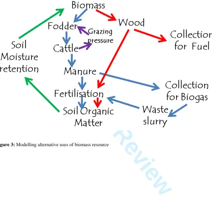
Monitoring and observation of current rates and patterns of biomass removal (fuel and
grazing) provide essential data when considering modelling the bio-mass balance for the
local area or region (Figure 3). Such data, combined with land use, vegetation data and
climate are the primary input into bio-physical models. The biophysical component of the
Pan-European Soil Erosion Assessment (PESERA) model. PESERA is a process-based
model that is designed to estimate long term average erosion rates at 1 km resolution and
has been applied in locations across Africa, Latin America and Asia through the DESIRE
project. The model is built around a partition of precipitation into components for
overland flow (infiltration excess, saturation excess and snowmelt), evapo-transpiration
and changes in soil moisture storage. Transpiration is used to drive a generic plant
For Peer Review
growth model for biomass, constrained as necessary by land use decisions, primarily on a
monthly time step. Leaf fall, with corrections for cropping, grazing etc, also drives a
simple model for soil organic matter. The runoff threshold for infiltration excess
overland flow depends dynamically on vegetation cover, organic matter and soil
properties, varying over the year. The distribution of daily rainfall totals has been fitted
to a Gamma distribution for each month, and drives overland flow and sediment transport
(proportional to the sum of overland flow squared) by summing over this distribution.
Total erosion is driven by erodibility, derived from soil properties, squared overland flow
discharge and gradient; it is assessed at the slope base to estimate total loss from the land,
and delivered to stream channels. The combined biophysical and biomass offer the
potential to consider resource management options under future scenarios and inform
further discussions between the study site researchers and stakeholders.
[Figures 3 & 4 here]
3.3 Selecting land degradation and SLM indicators
Finalise selection of indicators (in collaboration with likely users) to represent relevant
system components for ongoing monitoring by land managers (Figure 1, step 8):
Indicators identified during Workshop 1 (see section step 3, section 3.1) were evaluated
and selected on the basis of their ease of use (i.e. the ability of land managers to measure
them) and capacity to represent land degradation processes or the long-term sustainability
of land management (cf. Magole et al., 2008 and Bachman et al., 2007a&b). This built on
previous work by the team where indicators that had been identified in interviews were
evaluated and shortlisted in workshops using Multi-Criteria Evaluation and further
evaluated using field methods (Reed et al., 2008).
3.4 Promoting the application of SLM options and monitoring land degradation and
progress towards SLM goals 3
For Peer Review
Disseminate strategies and indicators for extension and national and international policy
(Figure 1, step 9): Although literacy levels are relatively high in Botswana (average 81%
according to Central Statistics Office (2004)), Boteti land users have no easy access to
computers and the internet. Consequently, the most appropriate means of disseminating
information to them would be through workshops, translated leaflets, manuals and
posters. Participatory workshops have already proven to be an effective means of local
stakeholder engagement. However, for national policy development and implementation,
web-based dissemination would be possible. SLM options from this project and previous
work (Reed and Dougill, 2010) were integrated, and linked to relevant indicators of land
degradation and SLM in a manual, targeted at land managers and extension workers. In
addition to biogas and game ranching, the manual includes a range of other SLM options
deemed relevant to the study area through previous work (Reed and Dougill, 2010), such
as changing livestock breeds, shifting grazing, managing bushes and various soil
management techniques. These materials and other more detailed results from the project
are also available via the DESIRE project’s “Harmonised Information System”, available
at: http://www.desire-his.eu/.
Apply SLM strategies, monitor degradation and progress towards SLM goals, upscaling
or aggregating to district and national levels (Figure 1, step 10): The results of the biogas
project with respect to the environmental and socio-economic objectives for which it was
adopted will be reviewed with land managers as soon as results become available.
Depending on its impact on woody vegetation conservation and socio-economic welfare,
the strategy could be implemented more broadly within the study village and in areas
within the region and beyond with similar circumstances. Ongoing monitoring using
indicators by land managers is facilitated through the dissemination of manuals linking
indicators to SLM options (see previous step). These manuals are being used as part of
the wider Government of Botswana’s implementation of its UNCCD National Action
Plan, under which it is hoped that these activities can be up-scaled to district and national
scales, and progress towards SLM goals can be monitored nationally.
For Peer Review
Adjust strategies to ensure goals are met (Figure 1, step 11): Finally, it should be noted
that as goals are met and contexts change, it may be necessary to develop or prioritise
new SLM strategies and indicators in future. Consequently, this framework is iterative,
represented by the dashed arrow between steps 11 and 4.
4 Results
4.1 Establishing land degradation and SLM context and sustainability goals
Figure 5 shows land degradation drivers and desertification risk according to structured
indicator questionnaires that were completed for each process deemed significant in each
of the land use types found in the study area (Figure 1, step 3, section 3.1 above). Boteti
stakeholders identified sustainability goals that addressed ecological (environmental)
integrity (as suggested by the objective of reducing the depletion of trees), economic
(livelihood) security (as suggested by the objective of minimizing the impact of drought
on arable production) and social equity (as indicated by the objective of reducing
poverty). These sustainability goals were a response to problems that are well
documented in the literature in this study area. For instance, the Boteti area has had the
highest proportion of permanent destitutes among the 5 sub-regions of the Central
District of Botswana (Central District Council, 2003). However, despite the many studies
that have identified rangeland degradation as a problem in this area (e.g. Ministry of
Agriculture, 1993; Ringrose et al., 1996; Perkins, 2007; Chanda, et al., 2007),
environmental sustainability goals focussed on the arable system and the availability of
water and fuel-wood.
[Table 1 here]
This may reflect a number of potential problems with the research that initially
identified rangeland degradation. In particular, Ringrose et al. (1996) inferred land
degradation from the presence of three indicators: (1) increased wind erosion and dust
For Peer Review
storms; (2) localised permanent damage to vegetation around villages and along the river;
(3) die-back of riverine forest (it is assumed due to lowering of water table or salinisation
due to unsustainable water extraction). It is clear that the riverine system has been
degraded in Boteti, due mainly to the loss of the Boteti flows, with losses in fishing and
flood plain agriculture. However there is less evidence to support the claim that grassland
resources in this area are degraded, and not simply responding to drought. Although
increased wind erosion may be a degradation indicator, it is also an indicator of drought.
Evidence of wind erosion features from remotely sensed data may simply indicate
drought conditions. Ringrose et al. (1996) detected wind erosion features from remote
sensing data collected in 1984, 1989 and 1993. Two of the three years were drought
years.
Permanent changes are evident around settlements, however these changes are
highly localised in extent and do not suppress the productivity of the livestock system.
Reed (2005) found that grass cover was high 2-4 km from villages in Boteti. The
dominant grass species, Cynodon dactylon was classified as “high grazing value” by van
Oudlshoorn’s (1999). In common with Ringrose et al. (1996), community members cited
a range of environmental problems, which they blamed predominantly on drought (Reed,
2005). When probed about the capacity of the land to recover after rain, the majority of
respondents interviewed by Reed (2005) emphasised the resilience of the grassland zone,
noting that rainfall produced sufficient fodder to maintain herds for at least two years. As
such few land users were constrained by their natural capital. However, community
members agreed that the mopane veld zone, which is less important for livestock
production, had experienced a decline in productivity. This was due to increased
dominance of C. mopane in response to grazing, leading to the suppression of grass.
Elsewhere in the mopaneregion of Botswana, the species is highly valued for forage.
However, elsewhere in Botswana it is usually valued in relation to available alternatives,
which tend to comprise less palatable annual grasses (Ringrose, pers. comm.), and it is
inferior to forage in the grassland zone in Boteti.
In conclusion, the riverine system in the study area is clearly degraded due to
declining river water levels and heavy stocking pressure within the riparian woodland.
The absence of flows along the Boteti from the late 1980s until recently has significantly
For Peer Review
constrained livelihood options for the local community, who once relied on fishing and
flood plain agriculture. Localised rangeland degradation is occurring around villages and
in the mopane veld zone. At present levels, this does not appear to threaten the
sustainability of livestock production in Boteti, but there are major concerns over
fuel-wood availability and water shortages. These concerns are reflected in the identification
and selection of SLM options that emerged from the two workshops.
4.2 Identifying, evaluating and selecting SLM strategies
Altogether, land users identified 13 SLM strategies during Workshop 1, out of which they
prioritized 4, viz: biogas as an alternative energy source, community wildlife (game)
farming, irrigation and dam-building (water harvesting). The DESIRE team investigated
three of these (biogas, water harvesting and game ranching) and another technology not
mentioned by the land users (solar power via solar cooker). In order to help them make
informed decisions about the technologies, the findings of the investigations were shared
with land users during Workshop 2. The latter four technologies were evaluated as
outlined under section 3.2 above. As Figures 6-8 below indicate, the technologies with
the highest beneficial environmental (ecological), economic and socio-cultural impacts
according to land users were community game ranching and biogas (cf. Magole et al,
2009). Figure 6 shows that there was considerable disagreement over the ecological
benefits of game ranching (indicated by the length of the horizontal line) compared to
biogas. Figures 7 and 8 show that there was considerable agreement however, over the
economic and socio-cultural benefits of game ranching, and that these benefits were
considered greater for game ranching than for other technologies.
The land users’ prioritization of game ranching was based on a number of social
and environmental considerations. Game ranching was perceived to have the potential to
bring economic returns for poverty alleviation (Table 1) and also to be a more viable
alternative to livestock farming which causes overgrazing. They reasoned that wildlife
species are better adapted to the semi-arid environment which they utilize more optimally
as grazers and browsers. On the other hand, biogas production and use was expected to
For Peer Review
reduce the need to collect firewood which is the main source of energy in the study area.
The stakeholders reasoned that by using biogas one can save time, use less labour and
save trees. Although it was marginally less popular than game ranching, the land users
ultimately settled for the biogas production strategy because the initial set-up costs were
lower, and hence could be implemented within the funding and time available within the
DESIRE project.
[Figure 6-8 here]
4.3 Selecting land degradation and SLM indicators
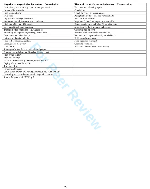
During Workshop 1, land users identified a wide array of indicators of both land
degradation and SLM (Table 2). Participants considered the positive indicators as
depicting past environmental conditions, confirming findings from earlier studies that the
people of Boteti perceive a long-term deterioration in their environment which, as
observed earlier, they readily link to climate desiccation and failure of Boteti floods (cf.
Chanda, 1996; Penning de Vries, 2007; Chanda and Darkoh, 2007).
[Table 2 here]
4.4 Applying SLM options and monitoring land degradation and progress towards SLM
goals
Monitoring of environmental and socio-economic impacts of adopting biogas as an
alternative domestic energy source is ongoing. However, the following baseline data has
been generated using the methods described under section 3.2 above:
There is indeed a very high dependency on firewood as a source of energy for
cooking (100% - Mopipi; 98.4% Mokoboxane), space heating (77% - Mopipi; 96% -
Mokoboxane), warming bath water (98.7% - Mopipi; 98.4% - Mokoboxane) and
various family events or ceremonies (78.5% - Mopipi; 83% - Mokoboxane);
For Peer Review
There has been mounting scarcity of firewood within more accessible areas (86% of
Mopipi and 90% of Mokoboxane respondents). This is supported by the increasing
use of donkey cart and motor vehicles in firewood collection, especially in the larger
village – Mopipi (88.9% of respondents);
On average, families use 10kg of firewood per day;
Most firewood is collected from communal land predominantly (not solely) lying in
the easterly direction;
There is enough cattle dung in the Mopipi area to support domestic biogas
production on a sustainable basis without compromising it use as organic fertiliser in
arable agriculture. The total dung output per animal per night was estimated at 5.4 kg
wet weight; and
Biomass of both live and dead fuel wood increases linearly with distance from the
village. Biomass of live trees (25 989 kg per ha average) was far greater than that of
dead wood (919 kg per ha average), suggesting depletion of the latter stock as people
currently depend on dead, rather than live, wood for energy. Colophospermum
mopane (the most preferred firewood species) contributed the most biomass of live
tree species and, expectedly, the least biomass to dead tree species – underscoring its
popularity as a firewood resource.
These results portray a situation of a decreasing stock of dead tree biomass for firewood
within collection zones. Thus the land users’ choice of biogas production as an
alternative energy source could be viewed as a proactive move intended to pre-empt
cutting of the now more accessible live trees for firewood.
Regional assessment of introducing biomass was elaborated based on the above
indicators. Figure 9 shows the location of boreholes as potential dung collection sites. To
simplify the analysis, we classified boreholes based on distance into 5 classes: less than 1
km (1.6%); 1-2km (0.5%); 2-5 km (4.0%); 5-11 km (18.8%); 11-20 km (41.5%); and
more than 20 km (33.6%). Importantly, dung collection from these sites is assumed to be
undertaken on foot (in the case of the first class), by cart (next two classes), or by van
(the remaining classes).
For Peer Review
The results from scenarios of introducing biogas are shown in Table 3. If we
assume a uniform distribution of cattle over boreholes (potential collection sites), all
dung required for operating biogas installations for the 872 households inhabiting
Mopipi and Mokoboxane will be collected from within a range of 11 km from the
villages; note that in this scenario (A) the six boreholes at less than a kilometre from the
villages are disregarded as dung collection on foot is uneconomical. Biogas is financially
attractive if firewood collection is about twice as costly as collecting dung. In view of
less attractive rangelands close to the villages, it is more likely that cattle is kept away
from the village.
If we assume all cattle is held beyond 11 km (scenario B), dung collection costs
for operating all biogas installations will rise by about 24%. The cost of firewood
collection at which biogas becomes a viable investment rises by about 12% relative to
Scenario A. Similarly, if cattle is kept at more than 20 km (Scenario C), dung collection
costs almost double (+81%) but firewood opportunity costs would need to rise 40% in
order to make the investment viable. Neither of Scenarios A-C is likely to be correct;
however these analyses show that cattle herding dynamics (e.g. in response to drought)
do not have to form an obstacle to adopting biogas.
Scenario D addresses what happens if the biogas installations do not perform (or
are not managed) efficiently and can only fulfil 75% of energy demand, with the
remaining 25% continuing to be provided by firewood. This obviously renders the
investment in biogas less attractive (i.e. a higher firewood opportunity cost is needed).
Importantly, the assessment method employed requires the share of firewood energy
substituted by biogas to be larger than 50% - any share lower than that means the
technology will never be viable from an individual decision-making perspective.
Scenario E addresses the fact that firewood collection costs may not yet be as high
as to push people to other alternatives, but may be on a rising trend. If we assume an
annual increase of 10%, reflecting both increased scarcity (and thus time) and distance
(transport and time) of firewood collection, adoption of biogas can anticipate these future
changes and be viable even if the current cost of firewood collection is lower than dung
collection costs.
For Peer Review
Scenario F represents Scenario A but assuming cattle dung from collection areas
close to the village would not involve opportunity costs of labour. This drops the cost of
dung collection and the minimum required opportunity cost of firewood collection to
67% and 60% of Scenario A respectively. In fact, taking the perspective of a pioneering
adopter of biogas who would exclusively collect dung from a nearby collection area
(from his/her own kraal for instance), the tipping point for opportunity cost of firewood
collection would go down further to P6.98 (36%).
Finally, scenario G reflects the extremely high cost and tipping point when dung
collection needs to be done on foot – taking into account labour opportunity costs.
Although this situation may be highly theoretical (a biogas adopter who is not in a
position to source dung using more economical means of transport would probably not
invest in the installation in the first place), it does show that there is considerable scope
for some entrepreneurs to create a local dung market and organize supply of dung to
biogas installations, or to develop a biogas market. The latter does however require
additional investment for pressure filling equipment and suitable cylinders to transport
biogas.
[Table 3 here]
5 Discussion
This paper builds upon a number of previous studies conducted in this area, and through
the integration of local and scientific knowledge, has provided a number of novel insights
that contrast with these previous studies. Most notably, the present study challenges the
nature and causes of land degradation identified previously, and hence suggests quite
different options for tackling land degradation in the study area. The study started by
identifying types and causes of land degradation with local communities, rather than
inferring this via natural science assessments of land degradation indicators. In contrast to
previous research based primarily on remote sensing (e.g. Ministry of Agriculture, 1993;
Ringrose et al., 1996), and studies by Reed et al. (2007, 2008) which focussed on
rangeland degradation, participants in this study emphasised problems associated with
For Peer Review
poverty, and degradation processes related to the depletion of fuel wood and water
shortages. In contrast to previous studies, which had a strong environmental and
rangeland focus, the present study considered land degradation and SLM in the broadest
possible context. In this way, although localised rangeland degradation issues were
identified (with associated indicators) they were not given undue importance, and other
issues were prioritised, leading to the selection of SLM options for trial that were
focussed on tackling poverty and fuel wood shortages.
In particular, the scenario analyses demonstrate considerable scope for biogas
production. The currently felt scarcity of firewood seems to indicate that the resource is
being overexploited. With 10 kg of firewood needed for each household each day, and
using the average of 919 kg/ha of dead wood biomass observed, annually at least an area
the size of 3460 ha is needed to satisfy the demand. This involves a 3.3 km search radius
from the villages. However, the current level of availability of firewood is already much
lower than average close to the village, and the harvesting of all dead wood is unlikely to
be sustainable. Therefore, it seems safe to assume the real search radius for firewood is
already much larger. Unlike dung, which is collected from kraals, firewood needs to be
collected from highly disperse areas, so that time and transport requirements are likely
much higher than for dung.
Simulations with the biophysical PESERA model will provide valuable insight in
the environmental effects of both firewood and dung collection dynamics. However,
ultimately an important social aspect is involved. As firewood is collected by women and
girls, perhaps at a perceived opportunity cost of zero, whether biogas will be taken up
depends on community recognition of the importance of freeing them of an onerous task.
Even when this is recognized, investment in biogas is expensive and beyond the
individual capacity to sustain; institutional arrangements are therefore needed, which may
be most effective if embedded in national level policy. Apart from financial viability and
environmental benefits, the rationale for supporting biogas development can be
considerably broadened, including potential industry development when scaling up,
energy saving, energy security, and health benefits by reducing smoke-related respiratory
diseases.
For Peer Review
The use of Multi-Criteria Evaluation makes the reasons why participants selected
particular SLM options transparent, and it is interesting to note that despite considerable
disagreement over the ecological benefits of game ranching, it was prioritised by
participants primarily for socio-cultural and economic reasons. Again, this emphasises
the need to consider the socio-cultural and economic aspects of land degradation and
sustainable land management alongside environmental dimensions. The contrast between
the results of this research and previous research in the area may therefore reflect a
difference in the relative priority that researchers and local stakeholders give to these
different dimensions of sustainability.
This further emphasises the need for methodological approaches such as those
proposed by Reed et al. (2011) and used in this research, which can integrate local and
scientific knowledge of land degradation and SLM. Rather than pitching local knowledge
(as collected in this research) against scientific knowledge (as per previous publications
in this study area), this research combines local and scientific knowledge of land
degradation problems and SLM options. Scientific knowledge contributed to the
understanding of these issues via land degradation indicators that were developed by
researchers and evaluating and applying SLM options (such as biogas) suggested by
researchers. Local knowledge then ensured that relevant SLM options were considered,
based on a local appreciation of land degradation problems (which differed to the
perceptions of most researchers), and only those that could best meet local needs and
priorities were implemented.
Although for some these different priorities may represent a conflict of interests
between researchers and local stakeholders, the participatory approach facilitated a close
working relationship between the research team and local communities, which translated
into strong local ownership of the adopted SLM strategies. The adopted SLM strategies
addressed an environmental problem with a strong link to priority livelihood issues.
Thus, environmental conservation has a concrete rather than theoretical or abstract
meaning to the lives of the land users. There was a very high land user appreciation of
what they referred to as the “DESIRE project process” of solving land use and
management problems. Land users unequivocally observed that DESIRE made them
realize that they possessed the ability to analyze their socio-economic circumstances and
For Peer Review
ultimately identify expert validated strategies to address locally genuine livelihood and
environmental problems. They further applauded the process for promoting cooperation
among various stakeholders and for affording them the opportunity to learn about the
various remediation strategies from DESIRE experts (see online supplementary
material). However, the Boteti experience also exposed a number of challenges to the
operationalization of the approach, which may be relevant to other developing country
contexts:
i) The high illiteracy rate among land users constrained progress with some of the
more technical exercises in the WOCAT process (e.g. impact chain analysis and
scoring of the strategies);
ii) High poverty levels among land users meant some remediation strategies were
beyond most people’s reach, requiring capital outlays (e.g. biogas production),
which delayed the piloting of agreed strategies. Indeed, it is on this account that
the most preferred (and arguably the most effective) remediation strategy
(community-based game ranching) could not be adopted for piloting. The
approach assumes that there will be a number of SLM options that are not already
being used by land users, that will not require significant capital investment or be
associated with significant opportunity costs, and this assumption may not be
valid in some of the poorest communities of the world
iii) WOCAT workshop 2 requires access to electricity to run the ‘facilitator
software’. While this was not a problem in the Boteti case, it would surely be an
obstacle in more remote areas with no or unreliable power supply
6. Conclusion
The dynamic, context-specific and value-laden nature of land degradation makes it hard
to address mechanistically. There can be no simple, universal system for assessing land
degradation or identifying relevant SLM options to prevent or tackle the problems it
causes. Instead, land degradation assessment must recognise a multiplicity of
perspectives, and cannot be judged in isolation from those who face its consequences
For Peer Review
(Warren, 2002; Reed et al., 2011) propose a methodological framework for land
degradation and SLM monitoring and assessment (Figure 1) that attempts to marry
information about environmental change from different research disciplines and
stakeholders. This paper shows how this framework has been applied in the Boteti
District of Botswana, one of the study sites for the DESIRE project.
The paper illustrates methods that may be used to operationalise Reed et al.’s
(2011) methodological framework, which could be applied in a variety of contexts
internationally. It identifies a number of benefits associated with the proposed
framework, notably related to insights arising from the integration of local and scientific
knowledge, and the ownership of the SLM strategies that emerged from the process.
However, implementing the framework was not without challenges. In some developing
country situations, the operationalization of the methodology might be restrained by
various challenges related to general underdevelopment or, as Penning de Vries (2007)
puts it, “capability” problems. As the framework is applied in different contexts through
the DESIRE project and elsewhere internationally (e.g. Ravera et al., in press), it will be
possible to learn more about how researchers and stakeholders can work more effectively
together to monitor and respond to land degradation.
Acknowledgements
This research was funded under EU Framework 6 Desertification Mitigation & Remediation of Land – a
Global Approach for Local Solutions (DESIRE) project contract no. 037046. It was conducted under
Government of Botswana research permit EWT3/3/8 XXXIX (21).and was supported by the University of
Botswana. Mark Reed is also funded by a British Academy Research Development Award. Special thanks
to the communities of Rakops, Mopipi and Mokoboxane.
References
Abel NOJ, Blaikie PM 1989. Land degradation, stocking rates and conservation policies in the communal
rangelands of Botswana and Zimbabwe. Land Degradation & Rehabilitation 1:101-123.
Atlhopheng JR, Chanda R, Mphinyane W, Sebego RJ 2009. Study site description, site 13 – Boteti.
DESIRE research project report. http://www.desire-project.eu 3
For Peer Review
Bachman F, Schwilch G, Gabathuler E, Liniger H 2007a. Guidelines for WB3 Part I: stakeholder workshop
1. Identification of existing and potential prevention and mitigation strategies. Centre for Development
and Environment (CDE), University of Bern, Switzerland. Report Number 6 of Manuals and Training
Guides. In collaboration with DESIRE Project.
Barrow CJ 1991. Land Degradation: Development and Breakdown of Terrestrial Environments.
Cambridge University Press, Cambridge.Central District Council 2003. Central District Development
Plan 6: 2003-2009. Central District Development Committee, Ministry of Local Government, Republic
of Botswana.
Central Statistics Office 2004. Botswana Literacy Survey 2003.
http://www.cso.gov.bw/html/liter_survey.htm
Chanda R 1996. Human perceptions of environmental degradation in a part of the Kalahari ecosystem.
Geojournal39: 65-71.
Chanda R, Darkoh MBK 2007. Feasibility of community-based rangeland management in Boteti,
Botswana: the role of tradition and policy. Component 2 Report for the UB-IVP-CAR collaborative
research project.
Chanda R, Atlhopheng JR, Magole L, Mphinyane W, Mulale K, Perkins JS, Sebego RJ 2009a. Drivers and
policy context of land degradation in the Boteti area, Botswana. DESIRE research report
Chanda R, Atlhopheng JR, Magole L, Mphinyane W, Mulale K, Perkins JS, Sebego RJ 2009b. Land
degradation indicators in Boteti – a triangulated approach. DESIRE research report
CSO (Central Statistics Office) 2008. Botswana Census-Based Poverty Map: District and Sub-district level
Results. Ministry of Finance and Development, Gaborone, Botswana.
Dean WRJ, Hoffman MT, Meadows ME, Milton SJ 1995. Desertification in the semiarid Karoo, South
Africa - review and reassessment Journal of Arid Environments 30: 247-264.
Department of Environmental Affairs 2006. Botswana National Action Programme to Combat
Desertification. Gaborone, Botswana.
de Vries Penning, L 2007. Combating desertification: bridging the gap – compatibility analysis of
Botswana’s national strategy to combat desertification with local land user’s perceptions and action
strategies. Dissertation paper; DESIRE, Wageningen University, Wageningen.
Fleskens L, Irvine B, Kirkby MK, Nainggolan D, Reed MS, Termansen M 2009. A model that integrates
the main bio-physical and socio-economic processes interacting within an agro-ecosystem. DESIRE
Report 63 D5.1.1 Aug09.Government of Botswana 1994. Desertification and possible solutions in the
Mid-Boteti River area: a Btswana case study for the Inter-governmental Convention to Combat
Desertification (INCD). Final Report, Volume 1 - The desertification process and its impacts. Ministry
of Agriculture, Gaborone, Botswana.
Holling CS 1986. The resilience of terrestrial ecosystems, local surprise and global change. In Sustainable
development of the biosphere, Clark WC, Mtmn RE (eds), Cambridge University Press, Cambridge;
292-317. 3
For Peer Review
Holling CS 2001. Understanding the Complexity of Economic, Ecological, and Social Systems. Ecosystems
4: 390-405.
IPCC (International Panel of Climate Change) 2001. Climate Change 2001: Impacts, Adaptation, and
Vulnerability, Cambridge University Press, Cambridge.
Kasperson J, Kasperson R, Turner B 1995. Regions at Risk. United Nations University Press.
http://www.unu.edu/unupress/unupbooks/uu14re/uu14re00.htm
Kates RW, Clark WC, Corell R, Hall JM, Jaeger CC, Lowe I, McCarthy JJ, Schnellnhuber HJ, Bolin B,
Huntley B, Jäger J, Jodha NS, Kasperson RE, Mabogunje A, Matson P, Mooney H, Moore B,
O’Riordan T, Svedin U 2001. Sustainability Science. Science292: 641-642.
Kirkby MJ, Irvine BJ, Jones RJA, Govers G, the PESERA team 2008. The PESERA coarse scale erosion
model for Europe: I – Model rationale and implementation. European Journal of Soil Science59:
1293-1306.
Lele SR, NorgaardRB2005. Practicing interdisciplinarity. BioScience 55: 967–975.
Magole L, Atlhopheng JR, Chanda R 2008. Stakeholder workshop 1: Land degradation and desertification
– existing and potential prevention and conservation strategies. Boteti First DESIRE WOCAT
workshop report.
Magole, L, Atlhopheng, JR and Chanda, R 2009. Stakeholder workshop 2: Selection and decision on
technologies / approaches to be implemented. Boteti First DESIRE WOCAT workshop report.
Ministry of Agriculture 1994. Desertification and possible solutions in the mid-Boteti River area: a
Botswana case study for the intergovernmental convention to combat desertification (INCD). Final
report: Volume 1 – the desertification process and its impacts. A Consultancy report prepared by a team
from the Department of Environmental Science, University of Botswana, April 1994 (164 pages).
Mulale, K, Chanda, R 2009. Drivers of desertification in the Boteti area of Botswana: law and policy.
DESIRE research report.
Perkins JS 2007. Ecological impact evaluation of current rangeland management regimes in Botswana,
with special reference to the eastern Kalahari. Component 1 Report for the UB-IVP-CAR collaborative
research project.
Reed MS 2005. Participatory Rangeland Monitoring and Management in the Kalahari, Botswana. PhD
Thesis, School of Earth & Environment, University of Leeds.
Reed MS, Dougill AJ, Taylor MJ 2007. Integrating local and scientific knowledge for adaptation to land
degradation: Kalahari rangeland management options. Land Degradation & Development18: 249-268.
Reed MS, Dougill AJ, Baker T 2008. Participatory indicator development: what can ecologists and local
communities learn from each other? Ecological Applications18: 1253–1269.
Reed MS, Dougill AJ 2010. Linking Degradation Assessment to Sustainable Land Management: a decision
support system for Kalahari pastoralists. Journal of Arid Environments74: 149–155.
Reed MS, Buenemann, M, Atlhopheng J, Akhtar-Schuster M, Bachmann F, Bastin G, Bigas H, Chanda R,
Dougill AJ, Essahli W, Evely AC, Fleskens L, Geeson N, Glass JH, Hessel R, Holden J, Ioris A, Kruger 3
For Peer Review
B, Liniger HP, Mphinyane W, Nainggolan D, Perkins J, Raymond CM, Ritsema CJ, Schwilch G,
Sebego R, Seely M, Stringer LC, Thomas R, Twomlow S, Verzandvoort S 2011. Cross-scale
monitoring and assessment of land degradation and sustainable land management: a methodological
framework for knowledge management. Land Degradation & Development.
Reed MS, Fazey I, Stringer LC, Raymond CM, Akhtar-Schuster M, Begni G, Bigas H, Brehm S, Briggs J,
Bryce R, Buckmaster S, Chanda R, Davies J, Diez E, Essahli W, Evely A, Geeson N, Hartmann I,
Holden J, Hubacek K, Ioris I, Kruger B, Laureano P, Phillipson J, Prell C, Quinn CH, Reeves AD, Seely
M, Thomas R, van der Werff Ten Bosch MJ, Vergunst P, Wagner L (in press) Knowledge management
for land degradation monitoring and assessment: an analysis of contemporary thinking. Land
Degradation & Development.
Republic of Botswana (2004) Summary statistics on small areas - Volume VII. 2001 Population and
Housing Census. Central Statistics Office, Government Printer, Gaborone, Botswana.
Ringrose S, Chanda R, Nkambwe M, Sefe F 1996. Environmental change in the mid-boteti area of
North-central Botswana: biophysical processes and human perceptions. Environmental Management20:
397-410
Schwilch G, Liniger HP, Bachmann F 2007b. Guidelines for WB3 Part II: Assessment of Conservation
Strategies. Assessment and documentation of existing and potential prevention and mitigation
strategies. Centre for Development and Environment (CDE), University of Bern, Switzerland. Report
Number 7 of Manuals and Training Guides. In collaboration with DESIRE Project.
Schwilch G, Bachmann F, Liniger H 2008. Guidelines for WB 3 Part III: stakeholder workshop 2. Selection
and decision on prevention and mitigation strategies to be implemented. Centre for Development and
Environment (CDE), University of Bern, Switzerland. Report Number 17 of Manuals and Training
Guides.Schwilch, G., Bachmann, F., Liniger H.P. 2009. Appraising and selecting conservation
measures to mitigate desertification and land degradation based on stakeholder participation and global
best practices. Land Degradation & Development 20: 308-326.
Schwilch G., Bestelmeyer B, Bunning S., Critchley W., Herrick J., Kellner K., Liniger H.P., Nachtergaele
F., Ritsema C.J., Schuster B., Tabo R., van Lynden G., Winslow M. 2011. Experiences in Monitoring
and Assessment of Sustainable Land Management. Land Degradation & Development (in press).
Doi10.1002/ldr.1040
Tietema T 1993. Biomass determination of fuelwood trees and bushes of Botswana, Southern Africa,
Forest Ecology and Management 60: 257-269.
Turpie JK, Crowe TM 1994. Patterns of distribution, diversity and endemism of larger African mammals
South African Journal of Zoology29: 19-32 .
Turner BL II, Bejamin P, 1993. Fragile lands and their management. In Agriculture, environment and
health: Towards sustainable development into 21st century, Ruttan VW (ed). University of Minnesota
Press, Minneapolis.
UNCBD 1992. United Nations convention on biological diversity. UNCBD Secretariat: Montreal. 3
For Peer Review
UNCCD (1994) United Nations Convention to Combat Desertification in Those Countries Experiencing
Serious Drought and/or Desertification Particularly in Africa: Text with Annexes, UNEP, Nairobi.
Warren A. 2002. Land degradation is contextual. Land Degradation and Development 13: 449–459.
Werger MJA, Coetzee BJ 1978. The Sudano-Zambezian Region. In Biogeography and ecology of southern
Africa, Werger MJA (ed). Junk, The Hague; 301–46.
White F 1983. The vegetation of Africa, a descriptive memoir to accompany the UNESCO/AETFAT/UNSO
Vegetation Map of Africa (3 Plates, Northwestern Africa, Northeastern Africa, and Southern Africa,
1:5,000,000), UNESCO, Paris. 3
For Peer Review
Table 1: Boteti land users’ objectives for sustainable land management (source: Workshop 1)
Objective Appropriate technology
Adequate approaches Responsible stakeholders To address the issue of
shortage of water
Building dams - Submit application for land.
- Submit application for financial assistance.
- Land Board - Farmers
- Agricultural extension workers
- Financial assistance agencies
To reduce the impact of drought on harvests
Irrigation farming - Submit application for land.
-Produce a management plan.
- Submit application for financial assistance -Produce a training plan for farmers.
- Village leaders (Village Development Committee). - Land Board
- Agricultural extension workers and soil specialists - Arable farmers
To reduce depletion of trees
Use bio-gas as energy for cooking
-Submit application for land.
- Submit application for financial assistance -Produce a training plan for implementers and or users.
- Village leaders (Village Development Committee). - Land Board
- Local community - Rural Industry Innovation Centre (RIIC)
To reduce poverty Divert to wildlife ranching
- Submit application for land.
-Produce a management plan.
- Submit application for financial assistance -Produce a training plan on wildlife ranching.
-Department of Wildlife and national parks (DWNP) and wildlife ranching experts - Village leaders (Village Development Committee). - Land Board
- Local community
Source: Magole et al. (2008), p.10.
For Peer Review
Table 2: Land user identified indicators
Negative or degradation indicators – Degradation The positive attributes or indicators – Conservation
Lack of vegetation, no regeneration and germination The river starts flowing again Uncontrollable winds Good rains
High temperatures Good harvests (high crop yields) Wild fires Acceptable levels of soil and water salinity Depletion of underground water Soil fertility increases
No dew (due to dry atmospheric conditions) Improved (raised) underground water table High mortality rate of livestock Dams, ponds, pans and lakes fill up with water. Low weight and weak livestock More food for both animals and people Trees and other vegetation (e.g. weeds) die Good vegetation cover
Browning (as opposed to greening) of the land Animals recover and start to reproduce Pans, dams and lakes dry up Increased and improved quality of wild fruits Extinction of certain plants Wild animals re-appear
Poor soil conditions, crusting Food becomes abundant Some grasses disappear Greening of the land
Low yields Birds and other wildlife begin to sing Shortage of water for both animals and people
Some of the soils become disturbed (loose, poor) High water salinity
High soil salinity
Wildlife disappears e.g. animals, butterflies, etc Drying of the river (Boteti R.)
Too much dust Poverty and hunger
Cattle tracks expose soil leading to erosion and sand mounds Increasing and spreading of certain vegetation species Source: Magole et al. (2008), p.7
For Peer Review
Table 3. Financial performance of biogas expressed in firewood collection opportunity costs under various scenarios.
Daily household dung collection costs
Daily household firewood collection opportunity costs
Pula %a Pula %a
Cattle distribution
Scenario A: Cattle uniformly distributeda 6.84 100 13.82 100
Scenario B: Cattle herds from 11 km 8.51 124 15.46 112
Scenario C: Cattle herds beyond 20km 12.37 181 19.35 140
Efficiency and socio-economic dynamics
Scenario D: Biogass covers 75% of demand 11.09 162 18.06 131
Scenario E: Firewood price rise trend 10% 6.84 100 6.45-18.47 47-134
Scenario F: No cost dung collection <1km 4.59 67 11.58 60
Scenario G: On foot dung collection only 95.93 1402 102.92 745
a
Scenario A is used as baseline; percentages are relative to this scenario.