Effect of Time Interval Variations on Network RTK in a High Multipath Environment 1
University of Southern Queensland
Faculty of Engineering & Surveying
Effect of Time Interval Variations on
Network RTK in a High Multipath
Environment
James McDonnell – 0061011923
Dissertation
Course: ENG4111 & ENG4112 – Research Project
Bachelor Spatial Science Honours (Surveying)
Effect of Time Interval Variations on Network RTK in a High Multipath Environment 2
Abstract
The research aim for this project was to investigate the effect of time interval
variations on Network RTK in a high multipath environment. Meaning does the time in between observing each point at the end of a line using Network RTK GNSS effect the accuracy of the calculated distance between the two points. And how is the relationship of time and accuracy affected when introduced to a high multipath environment. Finally, how can these determined accuracies for horizontal distance measurement be applied to survey regulation accuracy for cadastral surveys of 10mm + 50ppm stated in the CSR.
The analysis looked at two different datasets. First a dataset captured over a 12-hour period free from the effects of multipath. And secondly a dataset captured over a 12-hour period with the effect of multipath present. The analysis calculations used the Zero Distance Method and utilized two different time intervals firstly a 30-minute window and second a 5-minute window.
Effect of Time Interval Variations on Network RTK in a High Multipath Environment 3
Disclaimer
University of Southern Queensland
Faculty of Health, Engineering and Sciences
ENG4111 & ENG4112 Research Project
Limitations of Use
The Council of the University of Southern Queensland, its Faculty of Health,
Engineering and Sciences, and the staff of the University of Southern Queensland, do not accept any responsibility for the truth, accuracy or completeness of material contained within or associated with this dissertation.
Persons using all or any part of this material do so at their own risk, and not at the risk of the Council of the University of Southern Queensland, its Faculty of Health, Engineering and Sciences or the staff of the University of Southern Queensland.
Effect of Time Interval Variations on Network RTK in a High Multipath Environment 4
Certification
I certify that the ideas, designs and experimental work, results, analyses
and conclusions set out in this dissertation are entirely my own effort,
except where otherwise indicated and acknowledged.
I further certify that the work is original and has not been previously
submitted for assessment in any other course or institution, except
where specifically stated.
Name:
James Peter McDonnell
Student Number:
0061011923
………..
(Signature)
………
Effect of Time Interval Variations on Network RTK in a High Multipath Environment 5
Acknowledgements
This research project was carried out under the supervision of Associate Professor Peter Gibbings. With Professor Gibbings guidance, knowledge and assistance my understanding of a research topic that at times was difficult to understand throughout my research project year at the University of Southern Queensland is greatly
appreciated.
Appreciation is also due for the staff at C.R Kennedy Brisbane for their technical support and use of their Leica RTK GNSS equipment.
Effect of Time Interval Variations on Network RTK in a High Multipath Environment 6
Table of Contents
Abstract ... 2
Disclaimer ... 3
Certification ... 4
Acknowledgements ... 5
List of Figures ... 8
Chapter 1 – Introduction ... 9
1.2 Problem Statement ... 10
1.3 Research Aim... 13
1.4 Research Justification & Motivation ... 13
1.5 Research Method ... 13
1.6 Summary ... 14
Chapter 2 – Literature Review ... 15
2.1 Introduction ... 15
2.2 Network RTK GNSS ... 15
2.3 Multipath ... 19
2.4 Survey Standards & Guidelines ... 22
2.5 (Bein 2015) Research Project Review ... 23
2.6 Conclusion ... 24
Chapter 3 – Method ... 26
3.1 Introduction ... 26
3.2 Site Selection ... 26
3.3 Equipment Details ... 29
3.4 Data Collection Process ... 30
3.5 Data Analysis Process ... 33
3.6 Conclusion ... 36
Chapter 4 – Data Validation & Analysis ... 37
4.1 Introduction ... 37
4.2 Multipath Free Data Validation ... 37
4.3 Multipath Present Data Validation ... 40
4.4 Zero Distance Method 30 Minute Window ... 43
4.5 Zero Distance Method 5 Minute Window ... 46
4.6 Conclusion ... 48
Effect of Time Interval Variations on Network RTK in a High Multipath Environment 7
5.1 Introduction ... 49
5.2 Time Windows ... 49
5.3 Results Applied to CSR ... 50
5.4 Implications ... 52
5.5 Conclusion ... 53
Chapter 6 – Conclusion ... 54
6.1 Introduction ... 54
6.2 Meeting the Aims and Objectives ... 54
6.3 Further Research ... 55
6.4 Conclusion ... 56
References ... 58
Appendix A – Project Specification ... 60
Appendix B – Further Data Validation ... 61
Appendix C – Tabulated 1-Minute Subsets ... 63
Multipath Free 1-Minute Subsets ... 63
Effect of Time Interval Variations on Network RTK in a High Multipath Environment 8
List of Figures
Figure 1: RTK GNSS Diagram 17
Figure 2: Network RTK Diagram 18
Figure 3: SmartNet Aus SEQ Coverage Diagram 20
Figure 4: Multipath Diagram 22
Figure 5: Aluminium Multipath Disc 23
Figure 6: Selected Site (Acreage Property) 28
Figure 7: Receiver Setup – Multipath Free Environment 29
Figure 8: SmartNet Aus CORS Locality 29
Figure 9: RTK GNSS Equipment Setup 31
Figure 10: Multipath Instruments in Place 33
Figure 11: Multipath Instruments in Place 34
Figure 12: Example Raw Export from Data Recorder using Custom Output 35
Figure 13: Multipath Free – Easting Delta’s 39
Figure 14: Multipath Free – Northing Delta’s 40
Effect of Time Interval Variations on Network RTK in a High Multipath Environment 9
Chapter 1 – Introduction
Real-Time Kinematic (RTK) Global Navigation Satellite Systems (GNSS) has been a tool used by surveyors for over 20 years. Since its inception the technology and applied uses have changed dramatically over time. In recent years the introduction of more satellites to the GNSS constellations and a more reliable and increased
availability of Continuously Operating Reference Stations (CORS) in Australia has made RTK GNSS a tool surveyors choose to use more often over traditional survey methods. Most populated areas in Australia are now serviced by a Global System for Mobile Communication (GSM) and coverage by CORS Networks for survey grade RTK GNSS solutions has made GNSS based surveying even more appealing. For a surveyor to simply turn on their GNSS receiver connect to a CORS Network via a GSM connection and begin taking measurements and achieve the required accuracy improves field efficiencies and removes technical problems when a RTK Base needs to be established on site. With this RTK surveying system becoming a common tool for surveyors undertaking many tasks such as Engineering and Construction
Surveying, residential allotment staking and measuring distances in some Cadastral Surveying applications greater understanding is needed of the environmental errors that can adhere to this ease of use measuring system.
RTK GNSS is a complex system with numerous variables that can affect the
Effect of Time Interval Variations on Network RTK in a High Multipath Environment 10
The current Queensland Cadastral Survey Requirements (CSR) states that when taking RTK GNSS observations a minimum of 30 minutes should elapse before re-observing the same point for the purpose of deriving a distance (Spatial Policy of Department of Natural Resources and Mines 2015). With this requirement being a blanket requirement over all RTK GNSS surveying systems e.g. Single Base, Single Base via CORS and Network RTK via CORS it is not taking into account error reductions when using a Network RTK system. Greater understanding of the nature of Network RTK systems by the surveyor is needed to clearly identify the error budget for observations when Multipath is present and when is not and how this error budget evolves when lapse in time between observations also known as temporal change is introduced. With this type of analysis using temporal change as the variable, the survey requirements mentioned above will determine if necessary when using a Network RTK system. Of course the CSR is in place for real world survey conditions meaning a true laboratory style scientific test where all other variables are removed cannot be used as a comparative analysis of the CSR purpose.
With numerous research already conducted into the world of RTK GNSS Surveying and Cadastral Surveying involving RTK GNSS in Australia, a gap has been identified in the literature review below where further research is needed on how Network RTK surveying systems fits into that world and if it can be treated differently to the other more traditional RTK systems. The main questions that do arise are that is it affected by temporal change and multipath in the same way as other RTK systems and do the survey requirements established for RTK GNSS surveying really apply to the Network RTK Surveying System.
1.2 Problem Statement
Effect of Time Interval Variations on Network RTK in a High Multipath Environment 11
type conditions to analyse the variable of time on RTK GNSS observations. With (Bein 2015) conclusions restricted to these laboratory, non real-world conditions, further research is needed to extend this research to include real-world site-specific errors.
Multipath is one of the major potential site specific errors associated with RTK GNSS observations and detection of this observational error is difficult without redundant observations. Relying on temporal change to detect the error if the Multipath source is still present at the time of the second occupation is where the problem has
developed. Using a Network RTK GNSS system to capture the Multipath affected observations removes some potential environmental and systematic errors by
introducing redundancy into the calculated correction solution. Therefore, more onus is put back onto the GNSS receiver being used where the observation is taking place.
Effect of Time Interval Variations on Network RTK in a High Multipath Environment 12
For the application of data analysis when Multipath is present each epoch needs to be considered in its entirety when averaging the observations. Therefore averaging and analysing the single epochs collected post capture rather than relying on the data collector to find its own best fit and manipulating the raw data in the process will affect the results of the analysis. Even though this is not what would happen when conducting a real RTK GNSS survey it will better map the effect of multipath for this research.
It is widely known that to detect if an observation has been affected by the site specific error of Multipath additional observations must be taken after a certain time period so that the constellation of the satellites has changed creating a redundancy in the observation system because not all errors can be detected at the time of first observation which is why the variable of time is introduced.
With Network RTK becoming the common type of RTK system used by surveyors over single base setup it only makes sense to apply the multipath research to the Network RTK system. Therefore, the key problem being addressed in this research is as follows. Does time interval variations effect Network RTK observations in a high multipath environment?
The broad objectives from the research when trying to address the problem statement are as follows.
• Are there any affects to Network RTK GNSS observations when analysed against temporal change?
• Are there any affects to Network RTK GNSS observations when analysed against temporal change when Multipath is introduced?
• How will the well-documented expected accuracies differ when Multipath is introduced?
Effect of Time Interval Variations on Network RTK in a High Multipath Environment 13
1.3 Research Aim
To investigate the effect time interval variations have on Network RTK in a high multipath environment.
1.4 Research Justification & Motivation
There is a gap in research surrounding Network RTK GNSS and Multipath analysis. With Network RTK GNSS being one of the latest technological advances in the GNSS surveying industry and having a high adoption rate due to low upfront costs and improved efficiencies any further research surrounding this technology would be of great interest to the surveying community. With Multipath being the most common error occurring when conducting GNSS surveying tasks, any further research to analyse and map its occurrence when using Network RTK GNSS would give a better understanding of the random type of error to the surveying community.
My own motivation for this research beyond being a mandatory requirement for me to successfully complete my Bachelor Degree in Spatial Science Honours first came about after being in the audience of an undergraduate research project presentation at the University of Southern Queensland in September 2015. Their research on the “Effect of Time Interval Variations on RTK Derived Distances” and their suggestions of further research interested myself to explore this topic of time variations when conductions RTK GNSS surveys which has evolved to my research topic of this dissertation.
1.5 Research Method
To address both the aim and objectives of the research project the methodology of the data capture and analysis must take into account a few GNSS surveying factors such as satellite constellation orbits as well as a well-considered out data
management plan. The following is a broad outline of how the research will be
undertaken, a more in depth description of the methodology can be found in Chapter 3.
Effect of Time Interval Variations on Network RTK in a High Multipath Environment 14
• Conduct 12 hours of observations with Multipath present setup over same mark used in Multipath-free observations.
• Export observed data as a text format that includes X, Y, Z, Time, Number of Satellites, Horizontal Accuracy and Dilution of Precision and which can be imported into Microsoft Excel for data analysis.
• Using the data set with no Multipath a mean of all those observations will determine the true position of the observed point.
• Split data up into 60 second observations and average each set into one dataset which aligns with minimum survey standards.
• Compare and analyse individual datasets against each other at varied time intervals.
1.6 Summary
Chapter 1 gave a brief outline of the background information for this research topic thus setting the reader up for a better understanding of the problem statement of this research. It gave background information on Network RTK, multipath and survey regulations. And touched on where this research follows on from previous research in the subject area of time interval variations when observing and calculating
distances using RTK GNSS. From that the research aim was established, and the justification and motivation was outlined. Following that a brief outline of the methodology was described.
Effect of Time Interval Variations on Network RTK in a High Multipath Environment 15
Chapter 2 – Literature Review
2.1 Introduction
The following literature review and analysis is necessary to gain a broader
understanding of the research topic, fulfilling the research objectives and identifies the current gap of knowledge surrounding Network RTK and Multipath. The literature will review the principles of Network RTK GNSS and outline a brief history. The principles and occurrence of Multipath in relation to RTK GNSS systems will be explored. The survey standards and guidelines will be discussed to give a further insight and how they relate to this research project. And finally a review of previous research project from 2015 will be conducted to discuss his findings and how his research was conducted. It also must be noted that after completing the literature review it has been determined that numerous studies have been completed surround the accuracy and precision of RTK GNSS but little equivalent research can be found in relation to Multipath and its effects of Network RTK GNSS therefore reducing the literature review into the exact research topic and identifying the gap of recorded knowledge.
2.2 Network RTK GNSS
The principle of Real-Time Kinematic (RTK) Global Navigation Satellite System (GNSS) is very similar to conventional GNSS. A conventional GNSS calculates the position of the receiver purely from the signals received from the satellites. The receiver receives as many satellite signals it can from the available satellite constellation above and calculates its position using algorithms pre-set in the receiver. This method has an accuracy of approximately 10m (Kaplan & Hegarty 2006) and is widely used around the world for navigation. The reason the receiver can only calculate a positional accuracy to only 10m is due to the errors in the satellite signals which are created from satellite clock errors and the signal traveling through the atmosphere which can distort the signal.
Effect of Time Interval Variations on Network RTK in a High Multipath Environment 16
affected by errors created from the atmosphere thus a correction from this error must be included in the receiver’s algorithms. The method of using the phase observable signal and calculating the error and transferring that correction to the receiver is known as Real-Time Kinematic (RTK). The correction is calculated from a single base receiver or multiple base stations know as a network correction. The base receiver is stationary and is usually setup over a known geodetic coordinated point. The base receiver receives the satellite signals just like the rover but because the true position of the base receiver is known the signal correction can be calculated. This calculated correction must now be transferred to the mobile receiver also known as a rover in real time for its accuracy to improve. The two most common ways for the correction to be transferred to the rover is by radio link or via the internet.
However, the accuracy does begin to fade once the rover is further than 20km away from the base station, this is one major limitation of using a single base for
[image:16.595.110.484.423.634.2]corrections rather than a network solution. Figure 1 below demonstrates the basic system of RTK GNSS.
Figure 1: RTK GNSS Diagram
Effect of Time Interval Variations on Network RTK in a High Multipath Environment 17
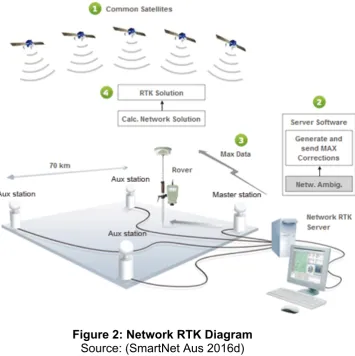
Network RTK is similar in many ways to Single Base RTK however the correction solution is calculated from multiple Continuously Operating Reference Stations (CORS) creating redundancy in the correction solution. A CORS system is comprised of four major elements including the reference stations themselves, a data processing centre, data communication system and the user connected to the system via the communication system (Wang & Hu 2013). When a rover is
connected to a CORS system usually via an internet connection to the networks computer server which manages all of the CORS in its service. The server receives real time data from all the reference stations and calculates the best correction solution depending on where the rover is located to the nearby reference stations. Figure 2 below is a diagram of how all the Reference Stations, Server, Satellites and Rover all interact in a Network RTK system.
[image:17.595.135.491.364.721.2]
Figure 2: Network RTK Diagram
Effect of Time Interval Variations on Network RTK in a High Multipath Environment 18
Depending on the rover being used there are different options of how the Network RTK solution is received and used in the position calculation. The main two are i-MAX and Virtual Reference Station (VRS). The main difference between the two is that i-MAX uses a real reference station and therefor has a traceable baseline and VRS uses a virtual point (SmartNet Aus 2016c). Both of these methods are
compatible with the RTCM (Radio Technical Commission for Maritime Services) format and is usually transported via NTRIP (Networked Transport of RTCM via Internet Protocol) (Garrido et al. 2011).
The main advantages of using a Network RTK solution are not only because it is cost effective and efficient it also creates a more reliable observation in the field. By using the network solution, it provides a more consistent result and reduces distance dependant errors (SmartNet Aus 2016b). It improves rover coverage, greater
reliability, more homogenous accuracy and faster times to fix ambiguities (Garrido et al. 2011)
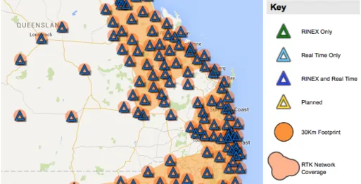
In Australia there are numerous CORS Networks offering Network RTK solutions for GNSS receiver, either being run by government or private entities. Some notable government run CORS Networks are CORSnet-NSW, AuScope Geospatial and Vicmap Position – GPSnet which its dense network spans the entire state of Victoria (Gowans 2010). The major private offerings are Checkpoint, Trimble VRS and SmartNet Aus which now has a presence in most populated areas in Australia. SmartNet Aus have been able to cover a majority of these areas which are
Effect of Time Interval Variations on Network RTK in a High Multipath Environment 19
Figure 3: SmartNet Aus SEQ Coverage Map
Source: (SmartNet Aus 2016a)
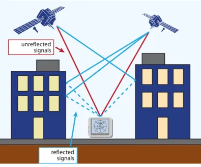
2.3 Multipath
Effect of Time Interval Variations on Network RTK in a High Multipath Environment 20
type of Multipath if scattered enough can make the signal unreadable by the antenna and therefor the rover is unable to calculate a position.
Multipath is one of the major errors involved with RTK GNSS and it is difficult to control, predict, detect and remove. Therefore, a surveyors best practice is
avoidance of high multipath environments and make redundant observations to help detect if Multipath is present. In newer receivers the algorithms and hardware have become more advanced to try to avoid and remove Multipath affected signals in real time. However, these features are not fool proof and are only there to help minimize the occurrence. It should also be noted that Multipath can not only affect the rover in RTK GNSS but it can also affect the base receiver used to calculate signal
corrections if placed in the wrong environment, meaning if the base has been
Effect of Time Interval Variations on Network RTK in a High Multipath Environment 21
[image:21.595.88.484.72.400.2]
Figure 4: Multipath Diagram
Source: (Spectracom 2015)
As mentioned earlier GNSS manufactures are continually improving their software and algorithms to detect and remove multipath affected signals from the calculated position. As well has hardware improvements such as choke rings and base plates attached to the antenna to potentially stop the affected signals reaching the antenna. However, for surveying purposes when a constant accuracy is required for all
observations the best mitigation technique is avoidance. Meaning being aware of your immediate environment, materials such as glass and metallic materials are highly reflective (Yi, Li & Gu 2012) and should always be avoided.
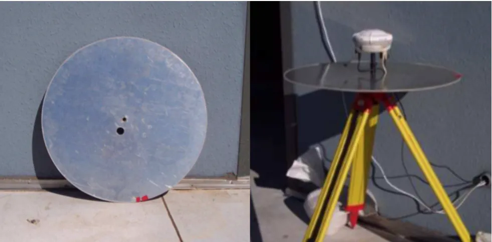
Effect of Time Interval Variations on Network RTK in a High Multipath Environment 22
[image:22.595.52.543.216.458.2]aluminium disc which is mounted beneath the GNSS receiver. Both (McCabe 2002) and (Mylne 2007a) concluded in their research that the multipath instrument did affect the GNSS receivers performance thus creating the desired effect. Figure 5 below shows (Mylne 2007a) aluminium disc detached and attached to the GNSS receiver during his research.
Figure 5: Aluminium Multipath Disc
Source:(Mylne 2007b)
2.4 Survey Standards & Guidelines
Surveying standards and regulations in Australia differ from state to state however all suggested surveying practices and guidelines to maintain accurate GNSS
observations are based from the Intergovernmental Committee on Surveying and Mapping (ICSM) Special Publication 1 (SP1). In relation to RTK GNSS and Network RTK GNSS observational techniques, SP1 outlines minimum practice when
establishing survey control. The recommend observation time for a single survey control point is an average of recorded positions for at least 1 minute after the rover has successfully initialised (Intergovernmental Committee on Surveying and
Effect of Time Interval Variations on Network RTK in a High Multipath Environment 23
least twice with at least 30 minutes between the two observations. The time window of 30 minutes is necessary noted in the Cadastral Survey Requirements (CSR) for detecting outliers if the mark is subject to multipath and / or obstructions to allow sufficient change in the satellite constellations (Spatial Policy of Department of
Natural Resources and Mines 2015). The Queensland Surveyors regulatory body the Surveyors Board of Queensland (SBQ) also mirror these observational techniques in their guidelines for Cadastral Surveys when a lack of understanding was identified in the profession (Gibbings 2012).
2.5 (Bein 2015) Research Project Review
(Bein 2015) completed a research dissertation last year as part of his completion of Bachelor of Spatial Science Degree at the University of Southern Queensland in 2015. His research was on the effect of time interval variations on RTK derived distances. His method of data capture is similar to the method used in the research project however Bein used an environment free of multipath and conducted the data capture in what is described in his dissertation as laboratory conditions and does not reflect the real world surveying environment. His observations were taken using a single base RTK GNSS for over a 24-hour period recording an epoch every second.
His data analysis was extensive and analysed numerous time windows and related his findings back to other previous research. Bein also used the method used in this research project to validate the captured data by determining the true absolute position of the recorded point by calculating and average of all the epochs over the 12-hour period. His analysis of each epoch compared to the calculated mean showed a random results with no noticeable trend or pattern present (Bein 2015).
Effect of Time Interval Variations on Network RTK in a High Multipath Environment 24
two different positions thus creating greater possibility for error to be introduced. The methods works under the assumption that in the absence of any measurement error the calculation of a distance between two records observed at the same location should produce a calculated value of zero (Gibbings & Zahl 2014a). This type of distance accuracy analysis will be used in the research project as well.
(Bein 2015) analysis found that using a shorter time window in between measuring both ends of a line proved to of higher accuracy. Thus his key finding was that a practitioner can observe either points of a line, in quick succession using the 1-minute observation time, for which a cadastral distance is to be derived when using RTK and comply with the CSR by not re-observing within the 30-minute window (Bein 2015).
However, it is noted in the research that further extensive research is still required before a definitive outcome can be concluded. There were also certain limitations noted in the research that may affect this research to be considered by governmental agencies when reviewing RTK GNSS standards and guidelines. Such as
observations were taken in laboratory conditions with no setup errors which cannot reflect the real world, observations were taken in an environment free of multipath and no observations were taken using a Network RTK system. With this research focusing on a high multipath environment it is expected that the results will differ in some ways.
2.6 Conclusion
Effect of Time Interval Variations on Network RTK in a High Multipath Environment 25
mitigate site specific errors when conducting RTK GNSS surveys. And finally a review of (Bein 2015) research where his research looked at these surveying practices outlined by the regulatory bodies.
The review has given an understanding to the reader how the RTK GNSS system works and why site specific errors such as multipath can greatly affect the desired accuracy of GNSS surveys. While there has been research aligning temporal change and GNSS measurements most recent (Bein 2015) there has been little aligning the effects of multipath with temporal change rather past research has always been of mitigation and detection. (Bein 2015) also noted this in his research and put it
Effect of Time Interval Variations on Network RTK in a High Multipath Environment 26
Chapter 3 – Method
3.1 Introduction
The literature review in Chapter 2 explored Network RTK and Multipath principles, surveying standards and guidelines and a review of (Bein 2015) research. This chapter will include a detailed description of the method of the data capture location, equipment utilised and the process of the data collection and analysis. This chapter will not only detail the methodology but why those steps were taken to give a better understanding of what is to be achieved from the research.
3.2 Site Selection
The location of the data capture must always be considered when using GNSS. For this research the receiver must be in a position with a wide unrestricted sky view and clear of any obstacles that could potentially create Multipath. It is important that the chosen environment is suitable for a multipath free data capture. This captured data set will be used to calculate a true position of the observed point, be used in
checking if multipath is in fact present in the Multipath present observations, analyse any patterns and of course compare against the multipath data set.
The site chosen is a residential acreage property with a large cleared area near the southern property boundary as shown in Figure 6. This large vacant area is a perfect location to conduct the data capture because being a secure site there is no
interference from members of the community interfering with the data capture
Effect of Time Interval Variations on Network RTK in a High Multipath Environment 27
Figure 6: Selected Site (Acreage Property)
Source: (Nearmap 2015)
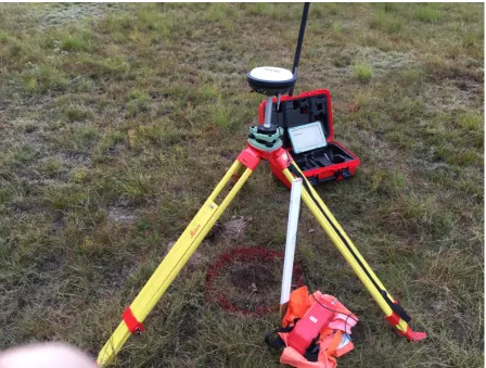
The site is located in the suburb of Sheldon which is on Brisbane’s south side along Mt Cotton Road. As shown in Figure 7, the receiver is positioned with an unrestricted sky view and with almost no objects or structures in its immediate vicinity. The
Effect of Time Interval Variations on Network RTK in a High Multipath Environment 28
Figure 7: Receiver Setup – Multipath Free Environment
Figure 8: SmartNet Aus CORS Locality
[image:28.595.84.516.422.721.2]Effect of Time Interval Variations on Network RTK in a High Multipath Environment 29
3.3 Equipment Details
The GNSS setup for the data capture is as follows:
GNSS Receiver
Model: Leica Viva GS16 GNSS Smart Receiver
Signal tracking: GPS (L1, L2, L2cC), Glonass (L1, L2), BeiDou (B1, B2), Galileo, QZSS and SBAS. Number channels 555.
Connections: Cable (USB & RS2320 and Bluetooth (V2.0) Power: External 12v Battery
Data Links: 3.75g GSM Antenna & Radio Modem Network RTK: VRS, FKP, iMAX, MAC (RTCM SC 104)
Data Recorder:
Model: Leica CS35 Tuff Tablet Software: Leica Captivate V2.0 Internal Storage: 128GB
Connections: Cable (USB & RS2320) & Bluetooth (V2.0)
Network RTK Service:
Network: Smart Net Aus
Connection Method: GSM Antenna Internet Connection Solution Method: iMAX
Effect of Time Interval Variations on Network RTK in a High Multipath Environment 30
Figure 9: RTK GNSS Equipment Setup
3.4 Data Collection Process
No Multipath Present Collection
Effect of Time Interval Variations on Network RTK in a High Multipath Environment 31
Multipath Present Collection
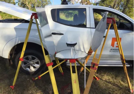
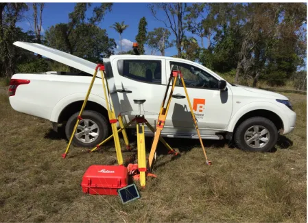
The same collection method is repeated from the no multipath present collection for the multipath present collection however the removable multipath instruments will be setup around the receiver to create a multipath environment.
Removable Multipath Instruments
The original intention was to just use the one reflective material similar to what McCabe and Mylne had used in their research however after some initial testing to create a multipath environment it was determined that this one reflective disc would not be enough to create the desired environment. After further testing using
Effect of Time Interval Variations on Network RTK in a High Multipath Environment 32
[image:32.595.73.524.155.470.2]
Effect of Time Interval Variations on Network RTK in a High Multipath Environment 33
Figure 11: Multipath Instruments in Place
3.5 Data Analysis Process
Once all the data is captured from both of the scenarios totalling 86,400 epochs it is then exported from the data controller in a useable format for Microsoft Excel.
Data Format
The data format used to be imported into Microsoft Excel is a Comma-Separated Values (CSV) file. With the following data columns:
• X • Y • Z • Time
• Number of Satellites • Horizontal Accuracy
Effect of Time Interval Variations on Network RTK in a High Multipath Environment 34
[image:34.595.73.523.430.648.2]This custom output specific to this research has been created using Leica Geo Office software. The software enables the user to create a custom output template for Leica data recorders meaning only the relevant information is handled and analysed for the research which is important due to the large size of the captured data. Figure 12 shows an extract of the captured data in its raw form using the export template. The data exported had an arbitrary coordinate system applied to make the data more useable during the analysis. The arbitrary system used is a planar grid system which was calculated by using the quick grid function on Leica’s Captivate software on board the data recorder. The X, Y, Z coordinates (X = 100.2… Y = 500.7… Z = 10.5…) were chosen because they will have smaller and more unique values compared to a MGA system. The planar system was chosen over MGA because ground distances need to be calculated in the analysis stage so they can be compared to previous research and survey requirements and guidelines.
Effect of Time Interval Variations on Network RTK in a High Multipath Environment 35
Data Processing Strategy
Firstly, the entire no multipath present data set will be used to calculate true position of the observed point by mathematical mean. This calculated mean will be used as the control or baseline for the data validation and analysis.
For both data sets the individual Epochs will be grouped into 1 minute intervals and the mean will be calculated for each 1-minute subset. The 1-minute interval has been chosen as this is the minimum time recommended in the SP1 document when establishing survey control and also used in (Bein 2015) research. Thus creating 720 values for both the multipath free and multipath present data sets, 1,440 in total.
Both data sets can then be compared against the true value position. The X and Y values for each minute subset will have the difference (delta) calculated and
graphed. This will show the error budget for each scenario, indicate if multipath has in fact been created and what differences if make to the point positions.
Once the data has been validated and determined that multipath is in fact present in the multipath present captured data. The zero distance method for calculating distances will be used with two different time lapse windows. The zero distance method calculates a distance between two points. The true distance will equal to zero as both observations used were recorded at the exact same position. This is the same method used in (Bein 2015) and (Gibbings & Zahl 2014a) research. With the true distance value of zero known a comparison against this value can be made and the analysis against the different time lapse windows can be made.
The first time lapse window chosen to analyse is a 30-minute window as this aligns with survey guidelines. The windowing strategy is as follows:
• Starting at minute 1 subset and calculating distance between minute subset 31. • Next calculating a distance between minute subset 2 and 32.
Effect of Time Interval Variations on Network RTK in a High Multipath Environment 36
• And follow that same pattern until all possible distances that can be calculated from the available 720 are complete.
• Use this window lapse strategy for both the multipath free and multipath present data sets.
• The calculated distance can then be graphed any analysed.
This same time lapse strategy will be used for the smaller time window of 5 minutes as well. A shorter time window was chosen because if results find no noticeable difference or if results are improved compared against the 30-minute time lapse it will help put further weight behind (Bein 2015) research which found that that there is a noticeable difference when analysing calculated distances over shorter time lapse windows.
3.6 Conclusion
Chapter 3 detailed the site selection, equipment used, the capture methodology. As well as including the data validation and analysis steps of the research to best answer the project aim.
Effect of Time Interval Variations on Network RTK in a High Multipath Environment 37
Chapter 4 – Data Validation & Analysis
4.1 Introduction
The first aim of chapter 4 is to validate both the multipath free and the multipath present datasets by analysing against the true calculated positional value of the receiver in the field capture. Once the multipath free data has been validated to prove that it has no effects of multipath and fits in with the expected accuracies in can therefore be used in further analysis. This is also the case for the multipath present dataset, once it has been validated to prove that in fact the dataset has been affected by a multipath environment for the entire 12-hour period it too can be used for further analysis.
Then the data can be analysed using the Zero Distance Method for the four different scenarios. 30-minute time lapse with and without multipath and 5-minute lapse with and without multipath. The calculated distances and analysis will then be graphed and accuracies calculated for the results to be discussed in chapter 5.
4.2 Multipath Free Data Validation
From the 12-hour multipath free data capture period which totalled to 43,200
individual records. The data needed to be first validated to make sure it came within expected RTK GNSS accuracies and could confidently confirm that the data was free of multipath interference for the entire 12-hour period. For this validation process a true point value of the observed point location needed to be determined to
calculate point positional accuracies against.
The true value was determined by calculating the mathematical mean of all the multipath free records. The calculated true position value is stated below.
True Positional Value:
Effect of Time Interval Variations on Network RTK in a High Multipath Environment 38
[image:38.595.76.531.279.524.2]The multipath free dataset was then grouped into 1-minute subsets totalling 720 averaged records that would be easier to manage during the validation and analysis processes. Note that a full tabulated list of all 720 records for the multipath free dataset can be found in Appendix C attached to this document. These subsets would then be compared against the true value calculating the difference (delta) for both the Easting and Northing values. Figure 13 and 14 below graph the delta values of the multipath free 1-minute subsets against the true value in both horizontal axis.
Figure 13: Multipath Free – Easting Delta’s
-0.1 -0.08 -0.06 -0.04 -0.02 0 0.02 0.04 0.06 0.08 0.1
Di
st
an
ce
-Me
te
rs
Time - Minutes
Effect of Time Interval Variations on Network RTK in a High Multipath Environment 39
Figure 14: Multipath Free – Northing Delta’s
The graphs above show no distinctive outliers or noticeable trends. All the values fit within +- 20mm, which is generally the expected accuracy of horizontal values using RTK GNSS. The 95% Confidence Interval of each dataset can also be compared against the manufactures horizontal accuracy specification of +- 8mm. From the descriptive statistics below (Table 1 and 2) and the graphs above (Figure 13 and 14) it can be stated that the multipath free data conforms to expected accuracies and has no indication of multipath interference for the entire 12-hour period.
-0.100 -0.080 -0.060 -0.040 -0.020 0.000 0.020 0.040 0.060 0.080 0.100
Di
st
an
ce
-Me
te
rs
Time - Minutes
Effect of Time Interval Variations on Network RTK in a High Multipath Environment 40
4.3 Multipath Present Data Validation
From the 12-hour multipath present data capture period which also totalled to 43,200 individual records. This dataset also needed to be validated to confirm that a
[image:40.595.67.529.80.515.2]multipath environment had in fact been created and was maintained for the entire 12-hour period. The same validation process conducted for the multipath free dataset would be used for the multipath present dataset. Grouping the data into 1-minute subsets totalling 720 records and calculating the difference (delta) from the True Positional Value used in the multipath free validation. Note that a full tabulated
Table 1 - Descriptive Statistics – Easting Multipath Free
Mean 100.20982
Standard Error 0.000158145
Median 100.2096917
Mode 100.2084
Standard Deviation 0.004243485
Sample Variance 1.80072E-05
Range 0.026633333
Minimum 100.1974333
Maximum 100.2240667
Sum 72151.0704
Count 720
[image:40.595.72.524.83.296.2]95% C.I 0.00831723
Table 2 – Descriptive Statistics – Northing Multipath Free
Mean 500.6959072
Standard Error 0.000171941
Median 500.6965583
Mode 500.6985667
Standard Deviation 0.004613648
Sample Variance 2.12857E-05
Range 0.0289
Minimum 500.67925
Maximum 500.70815
Sum 360501.0532
Count 720
Effect of Time Interval Variations on Network RTK in a High Multipath Environment 41
[image:41.595.70.527.297.540.2]list of all 720 records for the multipath present dataset can be found in Appendix C attached to this document. Figure 15 and 16 below graph the delta values of the multipath present 1-minute subsets against the true value in bot horizontal axis. Note that the vertical scale of the graphs has been chosen to best represent the detail of the data, however some large outlier values cannot be determined from these graphs. These large values will be discussed further in the following chapter.
Figure 15: Multipath Present – Easting Delta’s
-0.100 -0.080 -0.060 -0.040 -0.020 0.000 0.020 0.040 0.060 0.080 0.100
Di
st
an
ce
-Me
te
rs
Time - Minutes
Effect of Time Interval Variations on Network RTK in a High Multipath Environment 42
Figure 16: Multipath Present – Northing Delta’s
Comparing the multipath free graphs (Figure 13 and 14) against the multipath present graphs (Figure 15 and 16) there is a definite difference between the two datasets. The multipath present deltas have increased and the average accuracy is +- 40mm with some large outliers throughout the 12-hour period. By looking at the 95% Confidence Interval values below (Table 3 and 4) the values have increased over 10 times the multipath free values. With these noticeable differences it can be stated that an effective multipath environment has been created for the entire 12-hour period.
-0.100 -0.080 -0.060 -0.040 -0.020 0.000 0.020 0.040 0.060 0.080 0.100
Di
st
an
ce
-Me
te
rs
Time - Minutes
Effect of Time Interval Variations on Network RTK in a High Multipath Environment 43
Table 3 – Descriptive Statistics – Easting Multipath Present
Mean 100.2014618
Standard Error 0.001512532
Median 100.2024333
Mode 100.1614667
Standard Deviation 0.040585493
Sample Variance 0.001647182
Range 0.441933333
Minimum 100.0257333
Maximum 100.4676667
Sum 72145.05252
Count 720
[image:43.595.72.523.320.537.2]95% C.I 0.079547566
Table 4 – Descriptive Statistics – Northing Multipath Present
Mean 500.6959501
Standard Error 0.002511722
Median 500.6927583
Mode 500.6959167
Standard Deviation 0.06739658
Sample Variance 0.004542299
Range 0.942583333
Minimum 500.3207167
Maximum 501.2633
Sum 360501.0841
Count 720
95% C.I 0.132097297
4.4 Zero Distance Method 30 Minute Window
With both datasets validated the data analysis can take place using the Zero Distance Method. Note further data validation analysis for both datasets can be found in Appendix B attached to this document. The Zero Distance Method
Effect of Time Interval Variations on Network RTK in a High Multipath Environment 44
The first time lapse window applied to the two datasets will be 30 minutes. Figure 17 and Table 5 will show the calculated horizontal distances graphed and the
descriptive statistics tabulated respectively for the multipath free dataset. Figure 18 and Table 6 will show the calculated horizontal distances graphed and the
[image:44.595.72.525.234.481.2]descriptive statistics tabulated respectively for the multipath present dataset.
Figure 17: Multipath Free – 30-Minute Window – Horizontal Distance
Table 5 – Descriptive Statistics – 30 Min Window – Multipath Free - Horizontal Distance
Mean 0.007488303
Standard Error 0.000172356
Median 0.006588173
Standard Deviation 0.004527413
Sample Variance 2.04975E-05
Range 0.023600992
Minimum 0.000405518
Maximum 0.02400651
Sum 5.166929343
Count 690
95% C.I 0.011092162
0.000 0.020 0.040 0.060 0.080 0.100 0.120 0.140
Di
st
an
ce
-Me
te
rs
Time - Minutes
[image:44.595.74.522.552.769.2]Effect of Time Interval Variations on Network RTK in a High Multipath Environment 45
[image:45.595.65.527.102.349.2]
Figure 18: Multipath Present – 30-Minute Window – Horizontal Distance
Table 6 – Descriptive Statistics – 30 Min Window – Multipath Present - Horizontal Distance
Mean 0.053436945
Standard Error 0.004050006
Median 0.019372696
Standard Deviation 0.106384954
Sample Variance 0.011317758
Range 0.681463198
Minimum 0.001463728
Maximum 0.682926927
Sum 36.87149226
Count 690
95% C.I 0.260643138
0.000 0.020 0.040 0.060 0.080 0.100 0.120 0.140
Di
st
an
ce
-Me
te
rs
Time - Minutes
[image:45.595.67.522.459.664.2]Effect of Time Interval Variations on Network RTK in a High Multipath Environment 46
4.5 Zero Distance Method 5 Minute Window
The same Zero Distance Analysis Method used for the 30-minute window is applied to the 5-minute time lapse window. Figure 19 and Table 7 will show the calculated horizontal distances graphed and the descriptive statistics tabulated respectively for the multipath free dataset. Figure 20 and Table 8 will show the calculated horizontal distances graphed and the descriptive statistics tabulated respectively for the
[image:46.595.70.526.393.677.2]multipath present dataset.
Figure 19: Multipath Free – 5-Minute Window – Horizontal Distance
0.000 0.020 0.040 0.060 0.080 0.100 0.120 0.140
Di
st
an
ce
-Me
te
rs
Time - Minutes
Effect of Time Interval Variations on Network RTK in a High Multipath Environment 47
Table 7 – Descriptive Statistics – 5 Min Window – Multipath Free - Horizontal Distance
Mean 0.004942123
Standard Error 0.000105459
Median 0.004469185
Standard Deviation 0.002819912
Sample Variance 7.9519E-06
Range 0.018333069
Minimum 3.33333E-05
Maximum 0.018366402
Sum 3.533618094
Count 715
95% C.I 0.006908783
Figure 20: Multipath Present – 5-Minute Window – Horizontal Distance
0.000 0.020 0.040 0.060 0.080 0.100 0.120 0.140
Di
st
an
ce
-Me
te
rs
Time - Minutes
[image:47.595.66.529.305.600.2]Effect of Time Interval Variations on Network RTK in a High Multipath Environment 48
Table 8 – Descriptive Statistics – 5 Min Window – Multipath Present - Horizontal Distance
Mean 0.028199635
Standard Error 0.002922187
Median 0.008273687
Standard Deviation 0.078137773
Sample Variance 0.006105512
Range 0.5884597
Minimum 0.000271314
Maximum 0.588731014
Sum 20.16273871
Count 715
95% C.I 0.191437543
4.6 Conclusion
Effect of Time Interval Variations on Network RTK in a High Multipath Environment 49
Chapter 5 – Results & Discussions
5.1 Introduction
Chapter 5 directly follows on from the data validation and analysis in chapter 4. It will discuss in more detail how the time windows performed against each scenario. It will also discuss these findings in relation to the real world uses of calculating distances for the professional practitioner. By analysing the calculated accuracies against the survey standards for line measurement in the CSR. And finally the key findings will be discussed in regards to the implications this research may have on the surveying community and further research surrounding this subject.
5.2 Time Windows
With the data now validated and the zero distance calculations complete, the results of the Zero Distance Method can now be reviewed. The aim of the research was to consider Time Interval Variations in a high multipath environment. However, having the multipath free dataset as well the analysis can also be compared against
previous research.
The multipath free dataset can be directly compared against (Bein 2015) research. He too conducted analysis with observation time at 1-minute. With time lapse
windows of 5-minute and 30-minute also aligning with this research. A comparison of this research and (Bein 2015) of 95% Confidence Interval values is stated below.
1-Minute Observation Time with 30-Minute Window (Multipath Free)
95% C.I = 0.0111m 95% C.I (Bein 2015) = 0.0069m
1-Minute Observation Time with 5-Minute Window (Multipath Free)
95% C.I = 0.0069m 95% C.I (Bein 2015) = 0.0057m
Effect of Time Interval Variations on Network RTK in a High Multipath Environment 50
method. It must be noted that (Bein 2015) data capture was considered to be
laboratory conditions there for higher accuracy results would be expected compared to this research.
When applying this analysis to the multipath present dataset it too follows the same trend of the smaller time window producing higher accuracy which can be seen stated below. Meaning that even in a multipath environment the accuracy trend surrounding time windows is maintained.
1-Minute Observation Time with 30-Minute Window (Multipath Present)
95% C.I = 0.2606m
1-Minute Observation Time with 5-Minute Window (Multipath Present)
95% C.I = 0.1914m
5.3 Results Applied to CSR
Having gained this further knowledge on how both multipath free and multipath present datasets behave when calculating a distance using Network RTK. This can now be applied to use for surveyors. Just like (Bein 2015) and (Gibbings & Zahl 2014a) did in their research the accuracies determined above can be applied to the required accuracy stated in the CSR (Spatial Policy of Department of Natural
Resources and Mines 2015) of +- 10mm + 50ppm for measuring a distance for use in a cadastral survey. Meaning determining which distances can be adequately measured by Network RTK in the four different scenarios.
Effect of Time Interval Variations on Network RTK in a High Multipath Environment 51
while the 30-minute time lapse method would be suitable for distances over 30 meters. These results are similar to what (Bein 2015) found in his research however would not be considered as realistic measurement method for these short distance. Considering (Gibbings & Zahl 2014a) research which gave a detailed investigation into this question, the key finding was to consider distances over 378 meters
[image:51.595.73.526.240.495.2]adequate to be measured by RTK GNSS which is a more realistic value when RTK GNSS is consider as a whole full of potential environmental and systematic errors.
Figure 21: Distance Error Against CSR – Multipath Free Only
When the multipath present scenarios are introduced to this analysis the magnitude of the effects of multipath can be truly seen. In Figure 22 below which is set out similar to Figure 21 with the green line representing the function of +- 10mm +
50ppm. The results indicate that measurements using the 5-minute time lapse would be adequate for distance over 3.6km in a multipath environment. While
measurements using the 30-minute time lapse would be adequate for distances over 5km in a multipath environment.
0 0.005 0.01 0.015 0.02 0.025 0.03 0.035 0.04
0 50 100 150 200 250 300 350 400 450 500
ME
TE
RS
METERS
Distance Error Against CSR - Multipath Free Only
Effect of Time Interval Variations on Network RTK in a High Multipath Environment 52
Figure 22: Distance Error Against CSR – All Scenarios
5.4 Implications
This research follows on from previous research by (Bein 2015) and (Gibbings & Zahl 2014a) to gain greater knowledge surrounding using RTK GNSS in cadastral surveys. From this research there are no major implications in which will immediately affect the tried and tested procedures and guidelines already in place for when conducting cadastral surveys using RTK GNSS.
This research has just added to the knowledge base to which further improvements to procedures and guidelines can be made in the future after further research has been completed. This research has added further knowledge to the behaviour of Network RTK which aligns with (Bein 2015) research. And begins to add a starting point for further research of calculated distances in a multipath environment.
With the key findings in this research and past research indicating that measuring both ends of a line in quick succession using 1-minute observation time and will comply with the CSR. Proves possibilities for procedural and efficiencies
improvements for the survey practitioner. Of course it must be remembered that if using this procedure for calculating distances, sufficient checks and re-observation
0 0.05 0.1 0.15 0.2 0.25 0.3 0.35
0 500 1000 1500 2000 2500 3000 3500 4000 4500 5000 5500 6000
ME
TE
RS
METERS
Distance Error Against CSR - All Scenarios
Effect of Time Interval Variations on Network RTK in a High Multipath Environment 53
must be conducted to eliminate any outliers which has been well researched and documented.
5.5 Conclusion
Chapter 5 looked in depth into the results of the effects of time interval variations in both the multipath free and multipath present datasets. Focusing on the 95% Confidence Interval values which is commonly used as an indicator for accuracy. With the findings aligning with previous research even in the multipath environment it just adds further to the subject knowledge base.
The application of the calculated accuracies against the CSR requirements was an interesting point. If a practitioner is considering using RTK GNSS to calculate a distance in a multipath environment for cadastral purposes the line lengths
Effect of Time Interval Variations on Network RTK in a High Multipath Environment 54
Chapter 6 – Conclusion
6.1 Introduction
This research paper investigated the effects of time interval variations on Network RTK in a high multipath environment. The research successfully utilised a Network RTK solution in both a multipath free and a multipath present environment created by removable instruments. This artificial multipath environment proved to be a success and results in both scenarios aligned with previous research.
6.2 Meeting the Aims and Objectives
The research aim for this project was to investigate the effect time interval variations have on Network RTK in a high multipath environment. Which has been successfully achieved. The broad objectives derived from the problem statement have been addressed below.
Are there any affects to Network RTK GNSS observations when analysed against temporal change?
Yes, temporal change did affect the accuracy when using Network RTK to calculate a distance. Shorter time windows have found to be more accurate which align with previous research.
Are there any affects to Network RTK GNSS observations when analysed against temporal change when Multipath is introduced?
Effect of Time Interval Variations on Network RTK in a High Multipath Environment 55
How will the well-documented expected accuracies differ when Multipath is introduced?
The expected accuracies of RTK GNSS is well documented and aligns with the data captured in the multipath free environment. Showing no noticeable trends or
patterns, the random values fit within the expected error budget. With the multipath present data this too had no noticeable trends or patterns to the dataset but of course with a much larger error budget. However, one thing that could be noted is that the multipath environment created, did manage to create some very large errors over a meter in position in some instances. These large errors were created even though the received had maintained initialisation.
Will the analysis align with current recommended RTK GNSS Survey methods?
The research did differ from recommended RTK GNSS survey methods in a way. The research found that observing both ends of a line in quick succession proved to be more accurate than using observations with a 30-minte lapse in time as
recommended in the CSR. With sufficient checks this alternate method could be used to calculate distance in both a multipath free and multipath present
environment. Which just shows that it is up to the professional judgement,
experience and instrumentation knowledge of the surveyor when using RTK GNSS. One cannot only rely on the standards and guidelines when conducting a RTK GNSS survey especially in a multipath environment.
6.3 Further Research
The intention of this research was to add to the findings by (Bein 2015) and (Gibbings & Zahl 2014a). The variations in this research follow on from the limitations in the past research. With still so many limitations surrounding this research topic there is still a large need for further research which are listed below.
• Using a different Network RTK service in Australia or Internationally.
Effect of Time Interval Variations on Network RTK in a High Multipath Environment 56
• Conduct research using different satellite constellations especially with new GNSS services planned for the near future.
• Conduct research using different brand and model RTK GNSS instruments. • Conduct research in high multipath environment using a single base RTK
system.
• Conduct the same research but apply different time interval variations to the analysis.
With the knowledge base growing in this research topic there is a greater need for the research to continue. This further research must be undertaken to be considered and accepted in the RTK GNSS community and therefore make it a valid technique for the professional practitioner in the future.
6.4 Conclusion
The aim of this research was to investigate the effect of time interval variations on Network RTK in a high multipath environment which has been successfully achieved at the completion of this research. Whilst there is still need for further research in the subject of achieving accurate and efficient calculated distances using RTK GNSS there are some key findings that have come from this research which are stated below.
• Results achieved from Network RTK in a multipath free environment aligned with previous research using a single base RTK system. That is using observation times of 1-minute higher accuracy is achieved using a smaller time lapse window of 5-minutes to observe both ends of a line to calculate a distance rather than increasing the time window to 30-minutes.
Effect of Time Interval Variations on Network RTK in a High Multipath Environment 57
dramatically increase to meet standard measurement accuracies when in a multipath environment.
From these findings an alternative practice for calculating distances using RTK has been reaffirmed again which differs from survey regulations and guidelines but does meet the CSR measurement standard of 10mm + 50ppm. Meaning being a
professional practitioner using RTK GNSS instrumentation one cannot solely rely on the standards and guidelines when conducting a RTK GNSS survey especially in a multipath environment. The understanding of the RTK GNSS system coming from experience, professional judgement and instrumentation knowledge is what will help achieve the most accurate results than any guidelines especially in a multipath environment.
Effect of Time Interval Variations on Network RTK in a High Multipath Environment 58
References
Bein, V 2015, 'Effect of Time Interval Variations on RTK Derived Distances ', University of Southern Queensland.
Bilich, A & Larson, KM 2007, 'Mapping the GPS multipath environment using the signal-to-noise ratio (SNR)', Radio Science, vol. 42, no. 6, viewed 1/05/16.
Garrido, MS, Giménez, E, de Lacy, MC & Gil, AJ 2011, 'Surveying at the limits of local RTK networks: Test results from the perspective of high accuracy users',
International Journal of Applied Earth Observation and Geoinformation, vol. 13, no. 2, pp. 256-64.
Gibbings, P, RTK GNSS for Cadastral Surveys Guidline 2012, Surveyors Board of Queensland.
Gibbings, P & Zahl, M 2014a, 'When to consider RTK GNSS for a Cadastral Survey',
Spatial Science Queensland, Winter (July).
Gibbings, P & Zahl, M 2014b, 'Using RTK GNSS to Measure Cadastral Distances',
Spatial Science Queensland, Winter (July).
Gowans, N 2010, 'Network CORS: Who Wants It? ', UNSW.
Groves, PD 2013, RTK GNSS Diagram, Artech House,
<https://books.google.com.au/books?id=t94fAgAAQBAJ&lpg=PR5&ots=ByuiWXe7j&dq= GNSS&lr&pg=PR11 - v=onepage&q&f=false>.
Intergovernmental Committee on Surveying and Mapping, Guideline for Control Surveys by GNSS SP1 V2.1, 2014, Intergovernmental Committee on Surveying and Mapping, Commonwealth of Australia.
Kaplan, ED & Hegarty, CJ 2006, Understanding GPS: Principles and Applications, 2nd, Artech House, viewed 20/04/2016,
<https://books.google.com.au/books?hl=en&lr=&id=-sPXPuOW7ggC&oi=fnd&pg=PR7&dq=rtk+gps+principles&ots=2s5xxwULoG&sig=OWn We00Rn7mjkm57ZM-EpFOPo6c - v=onepage&q=rtk%20gps%20principles&f=false>.
Leica Geo Systems 2015, Leica GS14/GS16 User Manual.
Effect of Time Interval Variations on Network RTK in a High Multipath Environment 59
Leica Geo Systems 2016b, Leica CS20 & CS35 Data sheet.
Leica Geo Systems 2016c, Leica Viva GS16 Data sheet.
McCabe, R 2002, 'Performance Testing of the Trimble Zephyr Geodetic GPS Antenna', University of Southern Queensland.
Mylne, G 2007a, 'The Effectiveness of a Multiple-Frequency Global Navigation Satellite System (GNSS) on Multipath Mitigation', University of Southern
Queensland, USQ ePrints.
Mylne, G 2007b, Aluminium Multipath Disc, USQ ePrints.
SmartNet Aus 2016a, SEQ Coverage Map, SmartNet Aus, <http://smartnetaus.com/home/index.php?q=map>.
SmartNet Aus 2016b, How do I Evaluate a Network RTK Method?, SmartNet Aus, viewed 20/04/2015, <http://smartnetaus.com/home/index.php?q=node/34>.
SmartNet Aus 2016c, i-MAX and Virtual Reference Station, SmartNet Aus, viewed 20/04/2016, <http://smartnetaus.com/home/index.php?q=node/37>.
SmartNet Aus 2016d, Four basic parts of the relationship between the server and the rover in Network RTK, SmartNet Aus.
Spatial Policy of Department of Natural Resources and Mines, Cadastral Survey Requirements 2015, Version 7.1, 2015,
<<https://www.dnrm.qld.gov.au/__data/assets/pdf_file/0013/105601/cadastral-survey-requirements.pdf>.>.
Spectracom 2015, Multipath signals in urban environment, Spectracom, <http://manuals.spectracom.com/GSG/Content/GSG/Topics/Conc/Multipath.htm>.
Wang, L & Hu, W-s 2013, 'Study and Application in Road Survey on CORS Technique', Procedia - Social and Behavioral Sciences, vol. 96, pp. 1707-11.
Yi, T-H, Li, H-N & Gu, M 2012, 'Effect of different construction materials on
propagation of GPS monitoring signals', Measurement, vol. 45, no. 5, pp. 1126-39.
Effect of Time Interval Variations on Network RTK in a High Multipath Environment 60
Appendix A – Project Specification
For: James McDonnell
Title: Effect of Time Interval Variations on Network RTK in a High Multipath
Environment.
Major: Surveying
Supervisor: Peter Gibbings
Enrolment: ENG4111 – EXT S1, 2016
ENG4112 – EXT S2, 2016
Project Aim: To investigate the effect time interval variations have on Network RTK in a high multipath environment when in real world survey conditions.
Programme: Issue C, 15th March 2016
1. Research related background literature into RTK GNSS focusing on CORS / Network RTK, Multipath and why the survey requirements determined a time lapse between observations as best practice. Review V.Bein Research Project from last year from where this current research has evolved from and conduct similar data capture but with Network RTK and Multipath introduced which is suggest in his further research notes to answer our similar project aim.
2. Using Network RTK GNSS system, capture data in a real world environment with multipath present and not present. Conduct 12 hours of observation in each of the 2 scenarios to account for satellite constellation orbits. The use of a removable instrument to create multipath will help improve the comparable accuracy against the non-multipath observations as well as be sure that multipath is taking place.
3. Once the data has been collected it will be exported in a format of X, Y, Z Time, Number of Satellites, horizontal accuracy and Dilution of Precision and be imported into Microsoft excel for data analysis. Using the data set with no multipath a mean of all those measurements will determine the true position of the observed point. The data will then be spilt up into 60 second observations and averaged which is the minimum observation time recommended in the QLD CSR when using GNSS. These averaged observations will then be compared to each other at varied time intervals and differences calculated.