Precise Point Positioning: Is the Era of Differential GNSS Positioning
Drawing to an End?
Chris RIZOS, Volker JANSSEN, Craig ROBERTS and Thomas GRINTER, Australia
Key words: IGS, GNSS, PPP, CORS, RTK.
SUMMARY
Precise Point Positioning: Is the Era of Differential GNSS Positioning
Drawing to an End?
Chris RIZOS, Volker JANSSEN, Craig ROBERTS and Thomas GRINTER, Australia
1. INTRODUCTION
Precise Point Positioning (PPP) is a positioning method that employs widely and readily available Global Navigation Satellite System (GNSS) orbit and clock correction products, e.g. obtained via the International GNSS Service (IGS – http://igs.org), to perform point positioning using a single GNSS receiver.
PPP methods differ from differential GNSS (DGNSS) positioning methods in that differential techniques require access to the observations of one or more reference stations with known coordinates (Grinter and Roberts, 2011). This suggests that the PPP technique has an advantage over differential methods in that only a single receiver is necessary (at the user’s position), removing the need for the user to establish their own local reference station or to have access to observations from one (or more) reference station(s) operated by others. Consequently, the spatial operating range limit of differential techniques is overcome, as well as the need for simultaneous observations at both user and reference receivers. The “operating limit” for DGNSS varies from about 10 km in the case of the centimetre-level accuracy, carrier phase (CPH) based positioning techniques that use a single reference station, to perhaps several tens of kilometres in the case of network-based CPH techniques, to several hundreds of kilometres for metre-level accuracy, pseudo-range (PR) based positioning techniques (Rizos, 2010). (In this paper the focus will be on CPH-based GNSS positioning techniques.) Furthermore, PPP obviates the need for the user to obtain the reference station(s) observation data either in real-time or post-mission. Hence, overall, there is a reduction in labour and equipment costs, as well as simplified operational logistics (Gao, 2006).
PPP also provides a positioning solution in a dynamic, global reference frame such as the International Terrestrial Reference Frame (ITRF, see Altamimi et al., 2011), negating any local distortions associated with differential positioning techniques when local coordinates are used at the Continuously Operating Reference Station (CORS). However, it is important to fully understand the implications of transforming between a global and a national or local datum. This issue will not be dealt with in this paper, and the reader is referred to discussion in, for example, Haasdyk and Janssen (2011, 2012).
case of DGNSS techniques), reducing the time for resolving integer ambiguities (as required for centimetre-accurate solutions) is much harder to achieve.
Furthermore, because differencing techniques are not used in PPP algorithms, no relative ionospheric measurement delays can be assumed to cancel (or at least be significantly mitigated), and consequently dual-frequency receivers (capable of generating the 1st order ionosphere-free linear combination) are required for decimetre-level accuracy positioning (although this is also the case for differential techniques when the inter-receiver distance typically exceeds a few tens of kilometres).
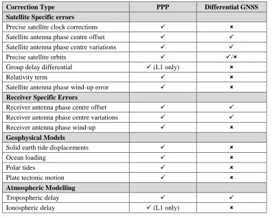
[image:3.595.102.498.362.680.2]PPP also requires a number of corrections to be applied to account for centimetre-level variations in undifferenced PR and CPH observation biases. In addition, phase wind-up corrections, satellite antenna phase centre corrections, solid earth tide corrections and ocean loading corrections are all necessary for accurate PPP solutions, but not considered for standard DGNSS techniques (i.e. short/medium-length static baselines, kinematic and Real-Time Kinematic (RTK) techniques) (Rizos, 2010). Table 1 lists the correction biases or errors to be modelled or otherwise accounted for in the case of PPP compared to differential positioning techniques.
Table 1: Biases and errors that need to be applied or accounted for in typical PPP and differential GNSS positioning techniques.
Correction Type PPP Differential GNSS
Satellite Specific errors
Precise satellite clock corrections
Satellite antenna phase centre offset
Satellite antenna phase centre variations
Precise satellite orbits /
Group delay differential (L1 only)
Relativity term
Satellite antenna phase wind-up error
Receiver Specific Errors
Receiver antenna phase centre offset
Receiver antenna phase centre variations
Receiver antenna phase wind-up
Geophysical Models
Solid earth tide displacements
Ocean loading
Polar tides
Plate tectonic motion
Atmospheric Modelling
Tropospheric delay
This paper gives a brief history of the development of PPP and reviews the advances made in PPP over the last two decades, with an emphasis on the past few years. The paper introduces post-processed online services, planned real-time PPP implementations as well as current commercial services, advances in integer ambiguity resolution for PPP, and the emergence of so-called “network-based” PPP techniques. The evolution of the IGS and commercial service providers in the context of supporting post-processed and real-time PPP techniques, now and in the future, will be briefly discussed. The paper also speculates on the evolving role(s) of CORS networks in the context of future PPP.
2. BRIEF HISTORY OF PPP
Whilst the evolution of PPP dates back to Anderle (1976), it was not until the late 1990s that this technique was seriously studied. Over the last two decades, dual-frequency PPP has been extensively researched, and several PPP software packages have been developed. It has been demonstrated that centimetre-level point positioning is achievable in post-processed, static receiver mode, and potentially also for kinematic applications (e.g. Zumberge et al., 1997; Gao and Kongzhe, 2004; Choy, 2009).
Recently, increased attention has focused on accessing accurate satellite orbits that have been computed with low latency and are available with frequent updates, or even orbits that have been “predicted” – such as the IGS ultra rapid orbits, cf. Table 2 – with the aim of supporting real-time or “near” real-time kinematic PPP applications. Discussions within IGS have been concerned with the provision of a time service to support an increasing demand in real-time products such as orbits, satellite clocks, and atmospheric parameters. The IGS Real Time Working Group (RTWG) was established to address issues relevant to the development of IGS real-time infrastructure and products. It has been running a pilot project for the past two years (http://www.rtigs.net), which has been such a success that the IGS may launch a real-time service in mid-2012 (Rizos, pers. comm.).
While post-processed PPP has many applications in geodesy – such as determination of the coordinates of receivers for the densification of the ITRF datum, or of static receivers in the context of earthquake studies (for determining pre-, co- and post-seismic motion), and the estimation of tropospheric delay – its use as an alternative positioning technique to DGNSS for surveying and mapping applications has been limited. This fact can be attributed to several reasons. Firstly, with the advent of cost-effective, centimetre-level accuracy, RTK-GNSS positioning provided by an increasing number of CORS networks around the world, there has been little need for PPP, a technique that does not (directly) use CORS services. Secondly, the availability of data products (i.e. orbits and satellite clock information) could, until recently, only support decimetre-level accuracy PPP via post-processed solutions. Thirdly, the RTCM message and data product standards to support PPP positioning are comparatively immature. Fourthly, no commercial off-the-shelf GNSS receivers have been marketed capable of generating positioning solutions using the PPP algorithm in real-time.
CORS coverage is not justified due to low population density or economic reasons (such as in developing countries). Will PPP be anything more than a niche high-accuracy GNSS technique? Advances have been made in PPP, especially in the past few years, which address the abovementioned limitations of PPP, and have the potential to increase the applicability of PPP techniques.
3. PPP SERVICES
3.1 Post-Processed PPP
At present, post-processed PPP (PP-PPP) offers the most comparable accuracies to DGNSS positioning techniques. Free PPP post-processing services such as Auto-GIPSY (http://apps.gdgps.net/) and CSRS-PPP ( http://www.geod.nrcan.gc.ca/products-produits/ppp_e.php) provide converged float solutions at the centimetre-level, thereby allowing PPP to offer a viable alternative to post-processed DGNSS solutions. Users upload their observed RINEX data files to such online services, and the coordinate solution for the (static or kinematic) GNSS receiver’s position is computed automatically. Note, however, that long observation session times (several hours) are required to obtain “comparable accuracies”, and therefore the applications are typically restricted to the establishment of geodetic control using GNSS technology. This is in contrast to “high-productivity” GNSS techniques which are used to determine the coordinates of points (or a user receiver’s trajectory) with centimetre accuracy, with just a few seconds or minutes of measurement epoch data (Rizos, 2010).
Ebner and Featherstone (2008) investigated a geodetic network solution across a 550 km by 440 km area in Western Australia composed of 46 points with 5-day GNSS receiver occupations. It was found that CSRS-PPP solutions were generally not significantly different from using the Bernese software (processing data in differential-network GNSS mode) solution used as ground truth. Whilst it was acknowledged that PPP was inherently less accurate than network-processed GNSS due to the inability to fix CPH integer ambiguities, this was balanced against the advantages of PPP. As PPP requires only a single dual-frequency GNSS receiver, this significantly reduced the equipment and personnel needed, as well as the pre-planning and logistics involved in a conventional network-based static GNSS geodetic survey. Furthermore, the processing time and skills needed to process conventional GNSS baselines is greater, compared to PP-PPP which involves sending the observed data files to a third party for coordinate determination. It was concluded that PPP yields a “slightly lower accuracy” but is a more cost-effective alternative to establishing geodetic control, particularly applicable in remote areas or developing countries. The authors also noted that at least two continuous days of observations were required to achieve reliable results, in this case interpreted as a PPP coordinate solution within 20 mm of the Bernese solution.
in Ellipsoidal Height), static applications using observation spans of 4 hours. The risk of outliers was minimised by utilising a longer observation window, while no further improvement was apparent between the 12-hour and 24-hour solutions within the specifications set for the study.
There are a number of PPP software packages that are capable of post-processing GPS (and in some cases GLONASS) data files. Most of these are software written by individuals at universities or research organisations. A well-known open source package is RTKLIB (http://gpspp.sakura.ne.jp/rtklib/rtklib.htm). As far as the authors are aware, there is no PP-PPP software offered by the mainstream GNSS instrument manufacturers. In addition, it must be emphasised that it is the availability of accurate satellite orbit and clock information from organisations such as the IGS (cf. Table 2) that makes PP-PPP viable at all.
3.2 Real-Time PPP
Operating in real-time is far more challenging than in post-processed mode. The critical issues are availability of measurement (and other) data, in real-time, over a wireless communications link, in a standard format that would allow GNSS receivers to operate reliably with minimum constraints and with comparative ease.
In the case of DGNSS techniques, the data that must be transmitted to user receivers is essentially the “raw” PR and CPH measurements from one or more reference receivers. Typically these are provided by a CORS network or user-operated reference receivers, either by a direct wireless link from the nearest reference receiver to the user, or via a link to a central network command centre (that itself monitors a network of reference receivers on a continuous, epoch-by-epoch basis). The broadcasts to users are by any physical means, such as short-range VHF/UHF, WiFi, mobile telephony or satellite communications link, and the data message format is in an industry standard such as RTCM (http://www.rtcm.org). There is no need for the transmission of ancillary data, such as precise satellite orbit or clock information, as the broadcast navigation message (modulated on the GNSS satellite L-band transmissions) contains system information accurate enough to support centimetre-level relative positioning. There are a number of implementations of high-accuracy DGNSS techniques such as RTK-GNSS and “network-based” RTK-GNSS (or NRTK-GNSS) (e.g. Rizos, 2010).
significant impost, both in terms of the provision of real-time satellite system data, and the wireless communications to access such data products. (It must be acknowledged that precise satellite orbit and clock information need not be computed “locally”, as such a process requires a relatively sparse ground reference station infrastructure and the data analysis capability can be centralised at a few computational facilities with the relevant expertise.)
The IGS RTWG has been investigating the issues associated with real-time CORS infrastructure and data products, and has been running a pilot project for the past two years (http://www.rtigs.net). The IGS plans to launch a Real-Time Service (IGS-RTS) in mid-2012. However, there are a number of issues that must be addressed in RT-PPP were it to be based on IGS products, not the least of which is (a) the mode of distribution of the real-time orbit and clock products, and (b) the format for such messages. To encourage user uptake of RT-PPP, the provision of IGS-RTS products on its own is not a sufficient condition (though it is an essential condition unless there is a commercial alternative to IGS-RTS products). Instrument manufacturers must implement RT-PPP algorithms inside GNSS receivers. This is generally presaged by the development of appropriate RTCM standards for the broadcast of precise orbit and clock information.
In an interesting development, recently a new, commercial real-time positioning product known as “Trimble RTX” has been released in the United States, bridging the “gap” between RT-PPP and NRTK-GNSS (Chen et al., 2011). A global CORS network (similar to the IGS’s) allows for the computation of precise satellite orbit and clock corrections, while a regional CORS network is used to determine local atmospheric corrections. It is claimed that this technique is capable of providing real-time positioning at the 4-centimetre level horizontally (95%), with initialisation times of less than one minute, delivering the necessary orbit and clock information via an L-band satellite downlink from a geostationary satellite. However, this is a proprietary system using non-industry standard message formats, and hence only Trimble brand user receivers (with special antennas able to track the necessary satellite communications link) can use such a RT-PPP service. Note, however, such a “network-based” RT-PPP technique may boost the popularity of PPP because it addresses several of the drawbacks of conventional PPP, although it must use some CORS infrastructure in order to do so.
4. DEVELOPMENTS IN PPP TECHNIQUES
Reference will only be made to those developments that improve the PPP technique so as to challenge the utility of DGNSS techniques for high-accuracy, high-productivity positioning (including in kinematic mode) applications.
4.1 From GPS to GNSS
(predicted)” (URP) product, the others only support PP-PPP. Note that although the predicted orbits are accurate enough for decimetre-level PPP (by assuming that the URP products have been downloaded hours in advance and are available for use by the receiver/computer at the instant measurements are made, i.e. in “real-time”), the predictability of the satellite clock corrections is relatively poor. A RT-PPP service would require an order of magnitude improvement in satellite clock estimates by effectively shortening the time between measurements being made by the PPP service provider’s CORSs, transferred to an analysis centre where the clock parameters are estimated, and then disseminated to RT-PPP users. This, of course, is the basis of the planned IGS-RTS as well as commercial alternatives such as Trimble’s RTX (Chen et al., 2011).
Table 2: Precise GPS satellite orbits and clock corrections provided by IGS
(http://igs.org/components/prods.html).
Despite the full constellation of GPS satellites, the number of visible satellites may be insufficient in areas such as urban canyons and mountainous regions. Even in open areas, poor satellite geometry may degrade the positional accuracy of PPP (as is the case of differential techniques). The ability to utilise extra satellites available in the GLONASS constellation enhances the capabilities of PPP and its possible applications (e.g. Cai and Gao, 2007; Azab et al., 2011). Currently four IGS analysis centres routinely provide GLONASS precise orbit products. The independent GLONASS orbits are of 10-15 cm level accuracy, and orbits from the four organisations are combined to generate the IGS final GLONASS orbits. Only two data analysis centres, IAC and ESA/ESOC, provide GLONASS clock data, accurate at the 1.5 ns level.
The use of GLONASS in kinematic PPP can further enhance the potential applications available to PPP. Currently the two IGS analysis centres offering GLONASS clock corrections provide satellite clock correction values with 5-minute intervals. Since this temporal density is not sufficient for most kinematic PPP applications, interpolation of the satellite clock corrections is necessary. Hesselbarth and Wanninger (2008) interpolated the GPS/GLONASS clock corrections produced by ESA/ESOC to 1-second corrections and analysed several PPP processing algorithms with kinematic GNSS observations. It was found that adding GLONASS satellites reduces PPP convergence times by about a factor of two. At intervals less than 30 seconds, no improvement in convergence times was evident.
Product Parameter Accuracy Latency
Ultra Rapid (predicted) Orbit 10 cm Real Time
Clock ~ 5 ns
Ultra Rapid (estimated)
Orbit < 5 cm
3 hrs
Clock ~ 0.2 ns
Rapid (estimated)
Orbit < 5 cm
17 hrs
Clock 0.1 ns
Final (estimated)
Orbit < 5 cm
The Galileo and Beidou constellations are currently being deployed. The IGS has launched a new initiative, the “Multi-GNSS Experiment” or M-GEX (see Call for Participation at ftp://igs.org/pub/resource/pubs/IGS M-GEX VF.pdf), seeking to establish a global tracking network of multi-GNSS capable tracking receivers and to encourage the analysis of the M-GEX data in order for the IGS analysis centres to gain valuable experience in computing satellite orbits and satellite clock products. M-GEX is a global project, commenced on 1st February 2012 and running to the end of August 2012 (at least in its first phase), that incorporates the regional multi-GNSS initiative of the Japanese Aerospace Exploration Agency (JAXA), seeking to promote the use of GNSS (including the JAXA Quasi-Zenith Satellite – the first of Japan’s GNSS augmentation satellites, see http://www.satnavi.jaxa.jp/e/news/qz-1109222_e.html). However, it is still too early to confidently predict the full benefits of multiple GNSS constellations – where over 100 satellites broadcast up to four times that number of signals on which PR and CPH measurements can be made.
4.2 PPP and Ambiguity Resolution
Conventional PPP involves the use of float solutions which require long observation times (>20 minutes) to converge to centimetre accuracy. Whilst this is a relatively short observation time for static positioning, it restricts the use of PPP for real-time and so-called “high-productivity” positioning applications. The fixing of integer ambiguities is usually only applied to double-differencing, as all unknown non-integer biases are eliminated or significantly mitigated in the measurement differencing process. Although the fixing of integer ambiguities is a particularly difficult challenge in undifferenced measurements, several methods have been developed to address this (e.g. Ge et al., 2008; Laurichesse et al., 2009; Collins et al., 2010; Geng et al., 2010; Laurichesse, 2011). In all cases, a CORS
network is utilised to aid fixed integer ambiguity resolution. This, in turn, reduces the time it
takes to achieve centimetre-level positioning accuracy, in principle allowing RT-PPP operations. However, the ability to constrain and correctly predict the ionospheric delay remains a key factor in enabling integer ambiguity resolution for PPP (Collins and Bisnath, 2011). It is therefore unlikely that a PPP solution using a global or wide-area CORS network will ever become as effective as short/medium-baseline RTK-GNSS or NRTK-GNSS techniques, due to the difficulty in providing sufficiently precise ionospheric corrections.
widespread availability of triple-frequency GNSS signals by the end of the decade will significantly speed up ambiguity resolution for both PPP and DGNSS techniques.
4.3 Single-Frequency PPP
Although the prospect of triple-frequency PPP is tantalising, such a capability is many years away from being a reality. On the other hand, dual-frequency PPP has already demonstrated the capability of providing accurate position solutions at the sub-decimetre level for kinematic positioning and sub-centimetre level for static positioning. However, since the majority of the mass-market GNSS users (navigation and GIS) operate single-frequency GPS receivers, PPP using a single-frequency GPS receiver has the potential to open up PPP to a broader range of applications. The large errors in single-frequency PPP, after the application of precise GPS orbit and clock products, are mainly due to ionospheric effects which cannot be mitigated effectively using single-frequency measurements (Chen and Gao, 2005).
Using the Klobuchar model, based on the ionospheric coefficients broadcast from the GPS satellites, is the simplest way to mitigate the ionospheric delay on measurements in single-frequency PPP. However, only about 50-60% of the total ionospheric effects are mitigated (Klobuchar, 1996). IGS has generated products with information on the Total Electron Content (TEC) of the ionosphere on a global scale since 1998 (http://igs.org/projects/iono/index.html). These Global Ionospheric Maps can provide better results than the Klobuchar model (Ovstedal, 2002), although the resolution is generally not sufficient to model ionospheric delay at a regional (let alone local) scale. Choy et al. (2009) investigated the achievable single-frequency PPP positioning accuracy using different types of receivers, in both post-processing and “simulated” real-time modes. It was found that single-frequency PP-PPP with a geodetic-quality GPS receiver is capable of achieving accuracies of 0.1 m horizontally and 0.4 m vertically (RMS, 1 sigma). In comparison, a medium-cost (GIS-grade) GPS receiver delivered 0.3 m horizontally and 0.7 m vertically, while a low-cost (hand-held) GPS receiver achieved 1.7 m horizontally and 3.3 m vertically. In RT-PPP mode, the achievable accuracies were considerably worse. Such performance is unlikely to challenge high-accuracy DGNSS techniques.
5. THE EVOLVING ROLE OF CORS NETWORKS
This paper sought to speculate on the evolving role(s) of CORS networks in the context of future PPP, and whether DGNSS techniques will be replaced by PPP techniques. We must again analyse the crucial advantage(s) that PPP proponents claim over DGNSS techniques
and consider the obstacles that must be overcome for PPP to be used for accuracy,
high-productivity position determination for all market scenarios in which current DGNSS techniques such as RTK-GNSS, NRTK-GNSS and wide-area DGNSS are applied. (It is
conceded that there will always be a role for PP-PPP in geodesy, however these applications
The authors contend that the availability of triple-frequency GNSS measurements may improve the speed with which ambiguity resolution can be achieved in PPP, because it is the relatively poor “time to first fix” that is currently the most significant shortcoming of PPP. But is the availability of multi-frequency PR and CPH measurements a sufficient condition to elevate PPP to a level of popularity that seriously challenges differential GNSS techniques? It is difficult to give an answer to that question. On the one hand ambiguity resolution for PPP will indeed be sped up, however it must also be emphasised that multi-frequency signal availability (and the resulting PR and CPH measurements) will benefit DGNSS techniques as well. One advantage of next generation multi-frequency measurements will be the relaxing of the inter-receiver – i.e. user to reference receiver(s) – distance constraint for high-accuracy, high-productivity DGNSS. This is currently of the order of several-to-many tens of kilometres in the case of NRTK-GNSS (or its equivalent, post-processed network-based DGNSS), and several simulation studies have reported that the density of CORS networks can be reduced such that reference receivers every few hundreds of kilometres would be sufficient (e.g. Feng et al., 2007). However, given the significant increase in the number of CORSs established over the last few years, the reduction in cost of upgrading CORS infrastructure (from GPS-only receivers to multi-GNSS receivers) compared to their initial deployment, the predicted “thinning” of CORS networks in the multi-frequency GNSS era, and the many other advantages of CORSs themselves (e.g. monitoring of ground or structural deformation and estimation of atmospheric parameters), the requirement for CORS infrastructure to support DGNSS may not be the significant disadvantage, or constraint, that it once was.
It has to be emphasised that the requirement for almost-ubiquitous wireless communications so that all users wishing to operate in real-time have access to broadcast RTCM correction messages is a critical requirement not only for real-time GNSS, but also for RT-PPP. However, satellite communications (SatComs) via the GNSS receiver “front-end”, as in the case of wide-area DGNSS such as Space-Based Augmentation Systems (SBASs) – e.g. the Wide Area Augmentation System (WAAS) in North America and the European Geostationary Navigation Overlay Service (EGNOS) (Prasad and Ruggieri, 2005) – is an attractive proposition.
Commercial implementations of RT-PPP, apart from Trimble’s RTX, will require access to data products such as those to be generated by the IGS-RTS from mid-2012. The CORS network infrastructure is already deployed, and under M-GEX will be upgraded to have multi-GNSS tracking capability. The analysis and real-time data product dissemination systems have been developed and are undergoing testing, and appear to be robust through the use of redundant analysis centres and broadcasters. Furthermore, industry data message standards are currently being finalised (Rizos, pers. comm.). All of these developments give confidence to GNSS receiver manufacturers that RT-PPP could be easily implemented at the in-receiver algorithm level, and that users could take advantage of RT-PPP if they have access to the real-time data product streams.
and to deliver “several” centimetre-level of positioning accuracy with a “few” minutes of initialisation (ambiguity resolution or ambiguity filter convergence – it is not clear from the published literature which is the case). What distinguishes this service from any that could be implemented via IGS-RTS products is that the necessary data stream (orbit, satellite clock and atmospheric delay parameters) comes via a SatCom downlink, obviating the need for a separate wireless communications link.
Trimble’s RTX is therefore in many respects very similar to SBAS implementations of wide-area DGNSS, except that it uses the CPH measurements to assure sub-decimetre-level (and potentially several-centimetre-level after “initialisation”) positioning accuracy, as all PPP techniques do. Hence this implementation addresses the requirement of ubiquitous wireless communications for users. However, CORS receiver spacing of 120 km (or so) seems to be a retrograde step vis-à-vis “pure” PPP, which has claimed there is no requirement for local/regional CORSs, except the few dozen global receivers needed to enable the computation of real-time orbit and satellite clock correction information.
Such a “network-based” PPP technique was demonstrated by Japanese investigators (Saito et al., 2011). They used the LEX signal transmitted by the Quasi-Zenith Satellite (http://qzss.jaxa.jp/index_e.html) to broadcast both the IGS-derived orbit and satellite clock data (i.e. based on the current URP product, not the IGS-RTS which is not yet operational) and atmospheric parameter information used to mitigate the tropospheric and ionospheric delay error on PR and CPH measurements. The latter were computed using those GEONET CORS receivers surrounding the test receiver. Few centimetre-level accuracy was achieved, in real-time, and used to control a driverless tractor. However, note that Japan’s CORS receiver spacing is on average about 30 km (http://www.gsi.go.jp/ENGLISH/page_e30030.html).
6. CONCLUDING REMARKS
PPP’s main advantage over DGNSS positioning techniques is the ability to provide an accurate position within a global reference frame, anywhere in the world with a single GNSS user receiver. Post-processed products and services from organisations such as the IGS and Natural Resources Canada have enabled PPP to offer a viable alternative to post-processed differential solutions, while maintaining the advantages of PPP, for geodetic users. The ability to utilise additional satellite constellations, such as GLONASS, Galileo and Beidou, will further enhance the capability of PPP. However, the fact that the reference frame of PPP results is not the datum of a nation or region does raise its own management issues (see, e.g., Haasdyk and Janssen, 2012, for some discussion on this matter).
due to the difficulty in providing sufficiently accurate ionospheric corrections. A regional CORS network with an inter-receiver spacing of the order of a “few” hundred kilometres (and preferably much less), however, has the potential to significantly improve the modelling of the spatial variability of the ionosphere’s TEC.
High-performance (i.e. high-accuracy and high-productivity) RT-PPP has been demonstrated, both in a commercial sense (Trimble’s RTX) and by researchers (QZS testing). However, CORS network densities similar to those for RTK/NRTK-GNSS techniques are required. While the provision of real-time IGS products and the finalisation of industry-agreed data formats will give a significant boost to RT-PPP, the challenge of transmitting such data to user receivers remains. Furthermore, it is debateable that RT-PPP will ever challenge RTK/NRTK-GNSS techniques on the grounds that it requires less or no CORS
infrastructure. The results so far suggest that the reduction in CORS infrastructure is not
significant if “network-based” PPP techniques are used. Paradoxically, CORS networks will play a large role in providing the corrections required to achieve RT-PPP results with centimetre-level accuracy. Because the need for CORS networks will not disappear, the authors contend that while PPP will be a useful addition to the GNSS “toolkit”, DGNSS-based techniques and services will still be a popular user option for many years to come because the justification for the establishment of CORS has not been weakened by recent developments in PPP.
REFERENCES
Altamimi Z, Collilieux X, Métivier L (2011) ITRF2008: An improved solution of the international terrestrial reference frame, Journal of Geodesy, 85(8), 457-473.
Anderle RJ (1976) Point positioning concept using precise ephemeris, Proc. Int. Geodetic
Symp.on Satellite Doppler Positioning, Las Cruces, New Mexico, 12-14 October, 47-75.
Azab M, El-Rabbany A, Shoukry MN, Khalil R (2011) Precise Point Positioning using combined GPS/GLONASS measurements, Proc. FIG Working Week 2011, Marrakech, Morocco, 18-22 May, 8pp.
Cai C, Gao Y (2007) Precise Point Positioning using combined GPS and GLONASS observations, Journal of Global Positioning Systems, 6(1), 13-22.
Chen K, Gao Y (2005) Real-time Precise Point Positioning using single frequency data, Proc.
ION GNSS 2005, Long Beach, California, 13-16 September, 1514-1523.
Chen X, Allison T, Cao W, Ferguson K, Grünig S, Gomez V, Kipka A, Köhler J, Landau H, Leandro R, Lu G, Stolz R, Talbot N (2011) Trimble RTX, an innovative new approach for Network RTK, Proc. ION GNSS 2011, Portland, Oregon, 19-23 September, 2214-2219.
Choy SL (2009) An investigation into the accuracy of single frequency PPP, Ph.D. Thesis, School of Mathematical and Geospatial Sciences, RMIT University, Melbourne, Australia.
Collins P, Bisnath S (2011) Issues in ambiguity resolution for Precise Point Positioning, Proc.
ION GNSS 2011, Portland, Oregon, 19-23 September, 679-687.
Collins P, Bisnath S, Lahaye F, Héroux P (2010) Undifferenced GPS ambiguity resolution using the decoupled clock model and ambiguity datum fixing, Navigation, 57(2), 123-135.
Ebner R, Featherstone WE (2008) How well can online GPS PPP post-processing services be used to establish geodetic survey control networks? Journal of Applied Geodesy, 2(3), 149-157.
Feng Y, Rizos C, Higgins M (2007) Multiple carrier ambiguity resolution methods and performance benefits for regional RTK and PPP GNSS positioning services, Proc. ION
GNSS 2007, Fort Worth, Texas, 25-28 September, 668-678.
Gao Y (2006) Precise Point Positioning and its challenges, Inside GNSS, 1(8), 16-18.
Gao Y, Kongzhe C (2004) Performance analysis of Precise Point Positioning using real-time orbit and clock products, Journal of Global Positioning Systems, 3(1-2), 95-100.
Ge M, Gendt G, Rothacher M, Shi C, Liu J (2008) Resolution of GPS carrier-phase ambiguities in Precise Point Positioning (PPP) with daily observations, Journal of Geodesy, 82(7), 389-399.
Geng J, Meng X, Dodson AH, Teferle FN (2010) Integer ambiguity resolution in Precise Point Positioning: Method comparison, Journal of Geodesy, 84(9), 569-581.
Grinter T, Janssen V (2012) Post-processed Precise Point Positioning: A viable alternative?
Proc. APAS2012, Wollongong, Australia, 19-21 March, 83-92 (e.g. accessible from
http://www.lpi.nsw.gov.au/surveying/corsnet-nsw/education_and_research).
Grinter T, Roberts C (2011) Precise Point Positioning: Where are we now? Proc. IGNSS2011, Sydney, Australia, 15-17 November, 15pp. (e.g. accessible from http://www.ignss.org/Conferences/PastPapers/tabid/64/Default.aspx).
Haasdyk J, Janssen V (2011) The many paths to a common ground: A comparison of transformations between GDA94 and ITRF, Proc. IGNSS2011, Sydney, Australia, 15-17
November, 16pp. (e.g. accessible from
http://www.ignss.org/Conferences/PastPapers/tabid/64/Default.aspx).
Haasdyk J, Janssen V (2012) Choosing the best path: Global to national coordinate transformations, Coordinates, 8(2), 10-16.
Henkel P, Günther C (2008) Precise Point Positioning with multiple Galileo frequencies,
Proc. IEEE/ION PLANS, Monterey, California, 5-8 May, 592-599.
Hesselbarth A, Wanninger L (2008) Short-term stability of GNSS satellite clocks and its effects on Precise Point Positioning, Proc. ION GNSS 2008, Savannah, Georgia, 16-19 September, 1855-1863.
Klobuchar JA (1996) Ionospheric effects on GPS, in Parkinson BW, Spilker JJ (Eds) Global
Positioning System: Theory and Applications Volume I, Progress in Astronautics and
Aeronautics, 163, American Institute of Aeronautics and Astronautics, Washington, 485-515.
Laurichesse D (2011) The CNES real-time PPP with undifferenced integer ambiguity resolution demonstrator, Proc. ION GNSS 2011, Portland, Oregon, 19-23 September, 654-662.
Laurichesse D, Mercier F, Berthias JP, Broca P, Cerri L (2009) Integer ambiguity resolution on undifferenced GPS phase measurements and its application to PPP and satellite precise orbit determination, Navigation, 56(2), 135-149.
Ovstedal O (2002) Absolute positioning with single frequency GPS receivers, GPS Solutions, 5(4), 33-44.
Prasad R, Ruggieri M (2005) Applied Satellite Navigation: Using GPS, Galileo, and
Augmentation Systems, Artech House Mobile Communications Series, ISBN
1-58053-814-2, 290pp.
Rizos C (2010) Making sense of the GNSS techniques, Chap 11 in Bossler J, Campbell JB, McMaster R, Rizos C (Eds) Manual of Geospatial Science and Technology, 2nd edition, Taylor & Francis, ISBN 978-1-4200-8733-8, 173-190.
Saito M, Sato Y, Miya M, Shima M, Omura Y, Takiguchi J, Asari K (2011) Centimeter-class augmentation system utilizing Quasi-Zenith Satellite, Proc. ION GNSS 2011, Portland, Oregon, 19-23 September, 1243-1253.
Zumberge JF, Heflin MB, Jefferson DC, Watkins MM, Webb FH (1997) Precise Point Positioning for the efficient and robust analysis of GPS data from large networks, Journal
of Geophysical Research, 102(3), 5005-5017.
BIOGRAPHICAL NOTES
Chris Rizos is the Head of the School of Surveying & Spatial Information Systems at the University of New South Wales (UNSW) in Sydney, Australia. Chris has been researching the technology and high-precision applications of GPS since 1985, and has authored/co-authored over 500 journal and conference papers. Chris established the Satellite Navigation and Positioning Lab at UNSW in the early 1990s, today Australia’s premier academic GPS and wireless positioning R&D group. He is a Fellow of the Australian Institute of Navigation, a Fellow of the U.S. Institute of Navigation, a Fellow of the International Association of Geodesy (IAG), and is the current President of the IAG. He is a member of the International GNSS Service (IGS) Governing Board and Co-Chair of Multi-GNSS Asia.
University of Tasmania between 2004 and 2009. Volker’s research interests are in the fields of geodesy and geodynamics, with an emphasis on GPS/GNSS studies and CORS networks.
Craig Roberts is a Senior Lecturer in Surveying/GPS/Geodesy at UNSW, Sydney, Australia. He holds a Bachelor of Surveying from the University of South Australia and a PhD in GPS for volcano monitoring from UNSW. He has worked as a private surveyor in Adelaide, a Geodetic Engineer at UNAVCO, USA involved with GPS for geodynamic studies in Nepal, Ethiopia, Argentina and Indonesia, a Geodetic Engineer at the GeoForschungsZentrum, Germany and lectured at RMIT University, Melbourne. His current research interests involve leveraging CORS infrastructure for practical application to surveying and spatial information capture.
Thomas Grinter is a Technical Surveyor in the Survey Infrastructure and Geodesy branch at NSW Land and Property Information in Bathurst, Australia. He graduated with a Bachelor of Surveying (Honours) from the University of Newcastle in 2008 where he was awarded the University Medal for his outstanding performance. He is currently a Research Masters student at UNSW.
CONTACTS
Prof Chris Rizos
School of Surveying and Spatial Information Systems The University of New South Wales
Sydney NSW 2052 AUSTRALIA
Tel. +61-2-9385 4205 Fax +61-2-9313 7493 Email: [email protected]
Web site: http://www.ssis.unsw.edu.au/
Dr Volker Janssen
Survey Infrastructure and Geodesy NSW Land and Property Information 346 Panorama Avenue
Bathurst NSW 2795 AUSTRALIA
Tel. +61-2-6332 8426 Fax +61-2-6332 8479
Email: [email protected] Web site: http://www.lpi.nsw.gov.au/
Dr Craig Roberts
School of Surveying and Spatial Information Systems The University of New South Wales
AUSTRALIA
Tel. +61-2-9385 4464 Fax +61-2-9313 7493
Email: [email protected]
Web site: http://www.ssis.unsw.edu.au/
Mr Thomas Grinter
Survey Infrastructure and Geodesy NSW Land and Property Information 346 Panorama Avenue
Bathurst NSW 2795 AUSTRALIA
Tel. +61-2-6332 8211 Fax +61-2-6332 8479