A Regional Collaborative Network to Improve Spatial
Information Sharing in Australia
Dev Raj Paudyal1, Kevin McDougall2, & Armando Apan3
Faculty of Engineering and Surveying Australian Centre for Sustainable Catchments
University of Southern Queensland, Queensland 4350, Australia Email: [email protected]; [email protected]; [email protected]
Abstract
Good outcomes in Natural Resource Management (NRM) rely largely upon effective mechanism to access and share spatial information. The largest body of spatial information is located within state government organisations and the current spatial information access and sharing mechanisms are managed by these agencies. Though various initiatives have been initiated by governments for building Spatial Data Infrastructure (SDI), the access and use of spatial information for NRM sector is problematic. Regional NRM groups are also collecting a significant amount of spatial information and state agencies are also interested in gaining access to this spatial data/information. There is an urgent need to bridge between the state approach and regional activities in an innovative way.
The aim of this paper is to explore the theoretical background for collaborative networks and examine the applicability of the regional collaborative network concept to improve spatial information sharing for informed decision making in NRM sector. Five spatial information sharing components are explored and based on those components, a comparison of the existing spatial information sharing approach and collaborative network approach has been presented. An overview of regional NRM bodies and information sharing in Australia has been discussed. A case study approach has been selected to apply the collaborative network approach for current NRM portal development. A comparative study of data hub projects in Queensland has been completed. This paper concludes that regional collaborative networks can facilitate the improvement of spatial information sharing and spatial data infrastructure development.
Keywords: Collaborative Networks, Spatial Information Sharing, Spatial Data Infrastructure, Natural Resource Management, Data Hub
1. INRODUCTION
of spatial information and state agencies are also interested in gaining access to this spatial data/information. The current flow of spatial information exchange is primarily one-way and based on known ‘published’ information (Queensland Regional NRM Groups Collective 2009). Significant amounts of ‘grey’ data (unpublished or uncatalogued) exist inside departments, and could be very useful for the NRM decision making process. In some cases, even people inside the department do not know what spatial information exits within their department. The current sharing of spatial information occurs through a data sharing agreement or ad hoc process. Much of the sharing is being done though personal contact rather than formal organisational processes.
In Australia, many initiatives have commenced for natural resource information access and sharing at different levels, with spatial information being just one of the components of natural resource information. At the national level, ANRII (Australian Natural Resource Information Infrastructure) was initiated to facilitate the access and sharing of natural resource information. Likewise, many NRM information portals and data hub projects have commenced at state and regional levels. The concept of spatial data infrastructure is already well established, however its effectiveness for the management of spatial information which cross administrative boundaries has been limited (Paudyal et al. 2009). Natural resource information does not understand the artificial jurisdictional boundaries that exist across natural catchments and landscapes. Therefore there is an urgent need to bridge the different initiatives for sharing of natural resource information in the national interest. The notion of “network” is nowadays a central issue in many fields including social sciences, communications, computer science, information science, physics, and even biology and ecosystems (Barabasi 2003; Dorogovtsev & Mendes 2003) . Among the various types of networks, of special relevance are collaborative networks. The collaborative network (CN) concept is a recognised concept for the collaboration and partnership across various domains (Camarinha-Matos & Afsarmanesh 2005). It is well-rooted in the industry sector, however, it is less well recognised or utilised in spatial data infrastructure (SDI) design and development. This concept has been identified as having potential for spatial information sharing between NRM groups/catchment management authorities and various government agencies.
The aim of this study is to explore the theoretical basis for collaborative networks and examine it’s applicability to sharing of spatial information between regional NRM groups/catchment authorities and government organisations. The concept will be evaluated through a case study approach in Australia.
2. COLLABORATIVE NETWORKS AND SPATIAL INFORMATION SHARING: A THEORETICAL PERSPECTIVE
operate through links between individuals and shared interests. They are informal arrangements with indistinct boundaries and fluid memberships. Networks and partnerships exist alongside each other. Sometimes a network is formalised and becomes a partnership. Often informal networks continue to operate in parallel with partnerships (McCabe et al. 1997). Networking involves basically communication and information exchange for mutual benefit. In networking, a group of entities share information about their experience with the use of a specific tool.
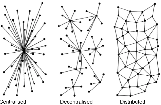
[image:3.595.146.478.320.537.2]In collaborative networks, the term ‘network’ is often used to describe many forms of inter-organisational relationships. The collaborating partners are linked together by a variety of relationship (Nohria & Eccles 1992)) and characterised by a high sense of mutual interest, active participation, and open communications (Faulkner 1995). A network can be simply an executive’s personal network of professional contacts or could describe virtual corporations consisting of many organisations (Warnest 2005). Baran (1964) categorised three basic forms of networks as centralised, decentralised (hub-and-spoke) and distributed networks as shown in Figure 1
Figure 1: Network Types (Baran 1964)
Centralised Decentralised Distributed
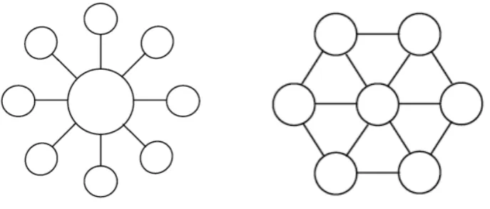
(Child & Faulkner 1998) categorised basic forms of networks into two forms as the dominated and equi-partner networks as shown in Figure 2a and 2b. A dominated network is formed by a single parent organisation and a number of discrete smaller satellite organisations with related business processes.Equi-partner networks are less formalised relationships between relatively equal organisations and are not controlled by a single dominant organisation.
A collaborative network is a network consisting of a variety of entities (e.g. organisations, people, and machines) that are largely autonomous, geographically distributed, and heterogeneous in terms of their operating environment, culture, social capital and goals, but that collaborate to better achieve common or compactable goals, and whose interactions are supported by computer networks (Camarinha-Matos et al. 2008). A review of organisational and collaboration literature suggests many and varied schools of thought about collaborative networks. Child and Faulkner (1998) studied cooperative strategies as part of collaboration and summarised four important theories as economic theory, game theory, strategic management theory and organisation theory to study theoretical perspective of collaboration. Lawrence et al. (2002, p. 5) identified the effect of collaboration in the context of networks referring to a form of institutional entrepreneurship. Camarinha-Matos & Afsarmanesh (2005) did extensive studies particularly focussing on collaborative networks and categorised the theoretical perspective of collaborative networks into structural, componential, functional, and behavioural dimensions.
[image:4.595.120.464.71.218.2]Figure 3: Collaborative Network Theory
Institutional/Organisational
Theory Network Theory
Collaborative Network Theory
Collaboration Literature
Dutton (2008) categorised collaborative networks into three types as sharing, contributing and co-creating. This paper is focussed on the sharing type of collaborative network and examined its usefulness for spatial information sharing.
3. DRIVERS AND MOTIVATIONS FOR COLLABORATIVE NETWORKED ORGANISATIONS (CNOs)
The drivers of CNOs can be broadly categorised under two headings: external drivers and internal drivers. External drivers include the environmental concerns, security concerns, economic pressure, changing demographics and social structures, cultural knowledge and value, information communication technology (ICT) and technological advancement and social media. Internal drivers include community needs, government policy, capacity issues inside government agencies, and inclusion (Camarinha-Matos & Afsarmanesh 2004)
The advent of spatial technology and web services enables more inclusive and open models of spatial services where grass-root citizens and community groups with no prior experience in spatial technologies can participate (Paudyal et al. 2009). More recently, the application and diffusion of the internet and information communication technology (ICT) has greatly expanded the opportunities for distributed working and the sharing of information and expertise. The use of social media for improving location enabled information sharing between emergency management agencies and the affected community is a very successful example of a collaborative network project. Confidence in collaborative networking has been growing. For instance, ‘Web 2.0’ applications have generated a wide range of proposals for employing ‘user-generated content’ and greater collaboration in a number of sectors, from social networking to corporate communication and information exchange. There is great scope for collaborative networking for spatial information sharing and SDI development.
4.1 Regional Collaborative Network
[image:6.595.114.504.289.472.2]Various regional collaborative networks already exit and lessons from their development and operation can be gleaned. This study is particularly focused on exploring the utilisation of regional collaborative networks to improve spatial information sharing for informed decision making in NRM sector. The word ‘regional’ has different meanings in different geographical regions. In Europe, Africa and some parts of Asia, regional means across international boundaries and includes groups of countries. However, in Australia, regional means the grouping between state and local authorities and includes some overlapping jurisdictional responsibilities (Masser & McDougall 2008). Figure 4 demonstrates the jurisdiction of regional services in Australia.
Figure 4 : Relation between inter-state services and regional services
Adapted from Masser & McDougall
(2008)
In Australia, regional NRM groups are responsible for integrated management of natural resources in their region (Robins & Dovers 2007). They are responsible for the delivery of natural resource management (NRM) programs and outcomes across catchments and other naturally defined geographical areas. The main functions of regional NRM groups include:
• Facilitating delivery of both environmental and economic benefits;
• Mobilising collaboration and partnerships between various stakeholders to
achieve significant NRM outcomes;
• Integrating state and national policies into local level action; • Facilitating integration of local and technical knowledge;
• Building capacity that has resulted in wide-spread, sustained changes in
land management practices; and
• Coordinating and contextualising action at regional and cross-regional
levels (Regional Chairs Collective Group 2009)
capacity of land mangers, value of commodities) (National Land and Water Resources Audit 2007). Much of the information is held and managed by government agencies; increasingly data is also being collected by community-based regional NRM groups and private sector. Regional NRM groups and other resource managers (e.g. agriculture industry, environmental groups and individual landholders) require quick and easy access to government, regional and local information to make informed decisions.
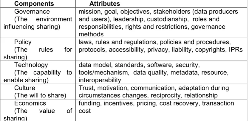
4.2 Spatial Information Sharing Components
[image:7.595.84.502.453.656.2]Australian Government Information Management Office (2009) has proposed some nine conditions for information sharing. They include provision of leadership, demonstrate value, act collaboratively, establish clear governance, establish custodianship guidelines, build for interoperability, use standards-based information, promote information re-use and ensure privacy and security. Pinto & Onsurd (1995) argued the factors to facilitate spatial information sharing between two or more GIS-using organisations are superordinate goals, bureaucratisation rules and procedures, incentives, accessibility, quality of relationships and resource scarcity. They demonstrated how these antecedent variables influenced the efficiency, effectiveness and enhanced decision making ability of organisation. This approach is based on organisational theory. The Office of the Director of National Intelligence (2008) has proposed a range of issues for information sharing that span governance, policy, technology, culture, and economic facets. Based on these three literatures five areas and their attributes are identified for spatial information sharing through collaborative networks. Table 1 describes these five key areas and their main attributes for spatial information sharing to improve NRM planning and decision making process.
Table 1: Spatial information sharing components
Components Attributes
Governance
(The environment influencing sharing)
mission, goal, objectives, stakeholders (data producers and users), leadership, custodianship, roles and responsibilities, rights and restrictions, governance methods
Policy
(The rules for sharing)
laws, rules and regulations, policies and procedures, protocols, accessibility, privacy, liability, copyrights, IPRs
Technology
(The capability to enable sharing)
data model, standards, software, security,
tools/mechanism, data quality, metadata, resource, interoperability
Culture
(The will to share)
Trust, motivation, communication, adaptation during circumstances changes, reciprocity, relationship Economics
(The value of sharing)
funding, incentives, pricing, cost recovery, transaction cost
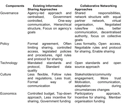
4.3 Comparison between existing information sharing approaches and collaborative networking approaches
[image:8.595.89.494.195.548.2]The existing information sharing approaches between NRM groups and government agencies is limiting across a range of dimensions. The following table compares the main differences between existing information sharing approaches and collaborative networking approaches.
Table 2: A comparison of existing information sharing approaches and collaborative networking approaches
Components Existing Information Sharing Approaches
Collaborative Networking Approaches
Governance Agency-led approach and centralised, Government controlled, One-way communication, Hierarchical structure, Focus on agency’s goals
Shared responsibilities, network structure with equal partner network, virtual organisation, Negotiated rules/few rules, better communication, decentralised authority, focus on collective goals
Policy Formal agreement, Often limiting sharing, controlled access, legislated policies and procedures, rigid rules and protocol for sharing
Less formality, Open access, Negotiable rules and protocol for sharing, Enable sharing
Technology Mandated standards and protocol, Standard data quality
Open standards and open source approach
Culture Less flexible, Follow rules and regulations, Less trust,
Formal way of
communication
Stakeholders/community engagement, More trust Motivation, communication,
adaptation during
circumstances changes Economics Controlled budget, Top-down
approach, Less incentive for sharing, Government funding
Participatory approach, Incentive for sharing, Member organisation funding
This comparison provides the basis for the development of a conceptual framework that can utilise the concept of collaborative networks for understanding data sharing for NRM groups.
5. OVERVIEW OF REGIONAL NRM BODIES AND INFORMATION SHARING IN AUSTRAIN CONTEXT
In total, there are 56 Regional NRM bodies and Catchment Management Authorities (CMAs) who work around Australia for natural resource management as seen in Figure 5.
Data Source: ERIN, DEWHA- NRM Regions (2009)
[image:9.595.112.483.77.388.2]The catchment management authorities/ Regional NRM bodies in Australia vary both in geographical coverage and terminology across the states. They are called Catchment Management Authorities in New South Wales and Victoria, Catchment Councils in Western Australia, Natural Resources Management Boards in South Australia, Regional NRM Groups in Queensland and Regional Committees in Tasmania. However, the common terminology of regional NRM bodies has been used in this paper. Table 3 provides a summary of current regional NRM bodies and arrangements in the Australian States.
Table 3: Regional NRM bodies and local authorities in Australian Jurisdiction
State Regional
NRM Bodies
Local Authorities
Main Collaborating State Government Organisation
NSW 13 152 Department of Natural Resources
(DNR)
VIC 10 79 Department of Sustainability and
Environment (DSE)
WA l 6 137 Department of Agriculture and Food
(DAF)
SA 8 73 Department of Water, Land and
Biodiversity Conversion (DWLBC)
QLD 14 74 Department of Environment and
Resource Management (DERM)
TAS 3 29 Department of Primary Industries
There are many initiatives for development of an Australia-wide information infrastructure to better support natural resource management policy, planning and decision-making. Recent environmental challenges has encouraged a national approach to meet the challenges of immediate and emerging whole-of-Australia and international issues such as the current water crisis, climate change and environment degradation. A road map of Australian Natural Resource Information Infrastructure (ANRII) has been developed to facilitate access and integration of NRM information to support decision making for sustainable natural resource management. The main components of the ANRII roadmap include partnerships, people, governance, information, standards, agreements and technology. The guiding principles include importance, accessibility, availability, standardisation, reciprocity, responsibility and priority (National Land and Water Resources Audit 2007). Likewise, at the State level a whole-of-State approach has been used to integrate local NRM activities and contribute whole-of-Australia approach for natural resource management activities.
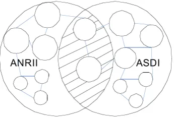
[image:10.595.223.396.436.553.2]There are many successful initiatives in natural resource management sectors and both top-down as well as bottom-up approaches exist. The Landcare movement is a collaborative network approach for improved natural resource management which works at grass-root level of community groups which work together to improve the natural resource outcomes of a local area. These local networks could be strengthened through regional collaborative networks. Figure 6 demonstrates the relationship between Australian Natural Resource Information Infrastructure (ANRII) and Australian Spatial Data Infrastructure (ASDI). The spatial component is common in both infrastructures.
Figure 6: Relationship between ANRII and ASDI
ANRII ASDI
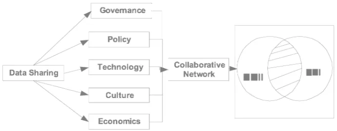
With this background and understanding of the role of the collaborative network approach, we try to develop a conceptual framework how spatial information sharing could be facilitated through the collaborative network approach and the possible role for SDI development (Figure 7). All five information sharing components are important to facilitate spatial information sharing between regional NRM groups and government agencies.
Figure 7: Role of Collaborating Network for SDI
6. CASE STUDIES
To evaluate the collaborative network principle for sharing spatial information between Regional NRM Groups/ CMAs and government agencies, a case study investigation was been undertaken to understand the value of the concept and its approach within the NRM context. The case studies consisted of a descriptive analysis of regional data hub initiatives within the state of Queensland, Australia. The purpose of these cases is to examine the collaborative network approach for NRM spatial information sharing between government agencies and NRM groups.
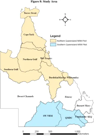
The selection of case-study areas was based on the availability and accessibility of NRM documents. The data collection method primarily consisted of the review of project documents and other available literature. The Queensland NRM Data Hub study was commenced in December 2007 and completed in May 2008. The objective of the study was to evaluate the business needs for data sharing (a two way process of knowledge exchange including data collection, data management and the availability of stakeholder data) between regional natural resource management groups, government agencies and industry stakeholders and to construct a business case for a project to improve data sharing (Queensland Regional NRM Groups Collective 2009). The main stakeholders of the data hub are Queensland regional NRM groups; Queensland Government NRM agencies (including system owners, information technology (IT) professionals, data providers and data users); the Local Government Association of Queensland (LGAQ); and industry groups. The study identified six NRM librarians and recommended for two pilots in northern and southern Queensland (Jones & Norman 2008).
Committee and the Department of Environment and Resources Management's (DERM) Catchment Programs. Queensland Murray-Darling Committee is the coordinator and DERM is the state agency involved in this project.
[image:12.595.154.473.155.616.2]The NRM groups concerned are shown in Figure 8.
Figure 8: Study Area
Data Source: ERIN, DEWHA- NRM Regions (2009)
The main objective of these pilot projects was to assist the further development of regional collaborative networks to improve NRM knowledge and information exchange (Sinclair & Kenyon 2009). It sought to identify ways to improve the sharing, availability, access, quality and quantity of data, information and knowledge required to service these needs and responsibilities.
Governance
Terrain NRM facilitated the Northern Queensland pilot project with the State agency the Department of Environment and Resource Management (DERM). This pilot project was a collaboration between Terrain NRM and six natural resource management regions of Torres Strait, Cape York, Northern Gulf, Southern Gulf, Wet Tropics and Northern Dry Tropics. The project team consisted of staff from a range of parties Including NRM groups and government. A project officer was employed in a knowledge broker’s role.
The Southern Queensland pilot project collaborated with the Queensland Regional NRM Groups Collective, South West NRM Ltd, Condamine Alliance, Queensland Murray-Darling Committee and the Department of Environment and Resource Management. Queensland Murray-Darling Committee is the coordinator of Southern Data Hub Project and state agency was Department of Environment and Resource Management (DERM).
The project is managed by the Qld Regional NRM Groups Collective (RGC) and four part time knowledge coordinators. Knowledge coordinators are working to develop an agreed state framework for the future management of regional NRM knowledge in Queensland.
Policy
The proposed NRM librarians initiative is aligned to the Australian Government’s “Caring for our Country” program national investment priority of “community skills, knowledge and engagement”. It is aligned via, improved managing and sharing information, increased availability and effective access to data, and knowledge systems stored within agencies.
In the Northern Queensland Pilot Project, it was planned to focus on a few key asset areas of the community based NRM agenda i.e. weeds, water and biodiversity. However, stakeholder consultation process advised the broader approach was more desirable. An agreement was made between stakeholders to work together for this project across a broader policy agenda. In the Southern Queensland Pilot Project, water is the theme selected for the pilot project.
The development of an independent state-wide steering committee that coordinates and communicates across existing networks and working groups is desirable to ensure NRM information is better integrated and delivered.
Technology
activities to improve information access and retrieval including the development of spatial databases, compilation and analysis of spatial data, establishment of communication networks, human resource development and infrastructure development.
Culture
The pilot found that there was a lack of a positive culture towards the appropriate storage, archiving and dissemination of spatial information. The data sharing culture was more through personal contacts rather than organisational procedure. People are willing to share data/information when asked, but don’t promote the fact that they have information available.
Economics
The projects were funded by Queensland Department of Environment and Resource Management (DERM), the Queensland Regional NRM Groups Collective and other collaborating organisations. The expectation from stakeholders is that all government funded data should be free and freely useable. Future natural resource management and related projects need to adopt better records of metadata as part of funding requirements.
7. DISCUSSION
The main aim of regional NRM bodies is to improve natural resource management at the regional scale. The spatial information management is a small but important part of their operations. However, in the data hub project, regional NRM bodies are focused on the collective goal of NRM information sharing. The state government organisations who holds most of the spatial information necessary for natural resource management is also involved in this project, however the role is primarily as a facilitator. This project is also driven by strong communities’ willingness to engage and their information needs. It has also been proposed to extend connectivity to state and national spatial portals. People are willing to share data/information when asked; therefore stakeholders can be motivated to share data through a data hub project.
From our case study, we tried to summarise the characteristics of data hub project based on the proposed five information sharing components. Table 4 summarise the main characteristic of data hub project.
Table 4: Characteristics of data hub project in Queensland
Components Characteristics
Governance Focus on collective goals, Shared responsibilities, Network structure with equal partner network for project management, State government facilitator, community ownership
Policy Aligned with the Australian Government’s “Caring for our Country” program , Open access to project partner, Negotiable rules and protocol for sharing
Technology Different capacity of managing geospatial technology, both open and proprietary software used, dedicated section or personnel for managing spatial information, limited use of technology
Economics State government and member organisation funding, No incentive for sharing
The main purpose of data hub project was to improve the NRM information sharing between regional NRM bodies and government agencies. From table 4, the characteristics of data hub concept satisfies closely with collaborative network concept. Therefore, this concept can be utilised to improve the data sharing between state regional NRM bodies and state government agencies.
There is good coordination between regional NRM groups and state government agency. The proposed data hub projects appear to be a good starting point to promote regional collaborative network in Queensland. As we discussed, the regional collaborative network can contribute to State and National collaborative networks. Therefore, a regional scale/approach may be more appropriate to manage natural resource information and develop natural resource information infrastructure. It also facilitates the bridging between local spatial data infrastructure and state spatial data infrastructure. We can see both top-down as well as bottom-up approach to improve access, use and sharing of natural resource information. The current spatial information sharing mechanism is mostly led by organisations with defined needs and mostly through the personal contact rather than organisational process. The data hub project itself is not a novel idea for sharing natural resource information. Many IT solutions have been already developed to solve the data sharing problem, however, the efficiency and effectiveness of that technical solution may be short term as well as limited. For the sustainability, stakeholder’s consultation and inclusion is very important. Trust and transparency play a role to motivate NRM agencies to share data.
8.
CONCLUDING REMARKS
A collaborative network is a hybrid of organisational and technological components and backed with organisational theory, network theory and collaboration literatures. Collaborative network is a recognised concept for the collaboration and partnership across various domains, well-rooted in the industry sector, however less well recognised or utilised in spatial information sharing and management. Many natural resource management processes, tools and products have been established with databases, web portals, libraries, search engines, publications etc. however they have not been well published or widely utilised. The ad hoc mechanism and approaches for their use need further improvement and development. The collaborative network potentially is an effective mechanism for spatial information sharing between regional NRM groups and state government agencies. The concept has been identified as having potential for spatial information sharing between NRM bodies/catchment management authorities and various levels of government agencies.
REFERENCES
AGIMO (2009).
National Government Information Sharing Strategy
, Australian
Government Information Management Office.
Rushton (Eds).
Sharing Geographic Information,
Urban Policy Research,
Rutgers, New Brunswick, New Jersey. pp. 22-43.
Barabasi, A.-L. (2003).
Linked.
Plume, New York.
Baran, P. (1964). On Distributed Communications: Introduction to Distributed
Communications Networks.
originally published in IEEE Transactions on
Communications Systems CS–12, 1964, now available online through RAND
Corp website at RM3420
(
Calkins, H.W. and R. Weatherbe. (1995). "Taxonomy of Spatial Data Sharing" in HJ
Onsurd and G Rushton (Eds).
Sharing Geographic Information,
Urban Policy
Research, Rutgers, New Brunswick, New Jersey. pp. 65-75.
Camarinha-Matos, L.M. and H. Afsarmanesh. (2004). "Collaborative Networked
Organisations: A research agenda for emerging business models" in Kluwer
Academic Publishers, New York, Boston, Dordrecht, London, Moscow. pp.
26-40.
Camarinha-Matos, L.M. and H. Afsarmanesh. (2005). Collaborative networks: a new
scientific discipline.
Journal of Intelligent Manufacturing, Springer
Science+Business Media, Inc. Manufactured in The Netherlands
16(1): 439–
52.
Camarinha-Matos, L.M., H. Afsarmanesh and M. Ollus. (2008). "ECOLEAD and
CNO Base Concepts" in LM Camarinha-Matos, H Afsarmanesh and M Ollus
(Eds).
Methods and Tools for Collaborative Networked Organizations,
Springer Science+Business Media, New York. pp. 1-32.
Child, J. and D. Faulkner. (1998).
Strategies of Cooperation: Managing Alliances,
Networks, and Joint Ventures.
Oxford University Press Inc, New York.
Dorogovtsev, S.N. and J.F.F. Mendes. (2003).
Evolution of Networks: From
Biological Nets to the Internet and WWW.
Oxford University Press, Oxford.
Dutton, W.H. (2008). The Wisdom of Collaborative Network Organizations:
Capturing the Value of Networked Individuals.
Prometheus
26(3): 211 — 30.
Faulkner, D. (1995).
International Strategic Alliances: Co-operating to Compete.
McGraw-Hill, London.
Kevany, M.J. (1995). "A Proposed Structure for Observing Data Sharing" in HJ
Onsurd and G Rushton (Eds).
Sharing Geographic Information,
Urban Policy
Research, Rutgers, New Brunswick, New Jersey. pp. 76-100.
Lawrence, T., C. Hardy and N. Phillips. (2002). Institutional Effects of
Interorganizational Collaboration, The Case of Mère et Enfant (Palestine).
Academy of Management Journal
45(1): 281-90.
Masser, I. (2005).
GIS Worlds, Creating Spatial Data Infrastructures.
ESRI Press,
Redlands,California.
Masser, I. and K. McDougall. (2008). Regional SDIs in Australia. May 19-20.
McCabe, A., V. Lowndes and C. Skelcher. (1997).
Partnerships and networks: An
evaluation and development manual.
Joseph Rountree Foundation,
Layerthorpe, England.
McDougall, K. (2006).
A Local-State Government Spatial Data Sharing Partnership
Model to Facilitate SDI Development
. University of Melbourne.
Meredith, P.H. (1995). "Distributed GIS: if its time is Now, Why is it resisted?" in HJ
Onsurd and G Rushton (Eds).
Sharing Geographic Information,
Urban Policy
Research, Rutgers, New Brunswick, New Jersey. pp. 7-21.
National Land and Water Resources Audit (2007).
Developing a vision and roadmap
for an Australian Natural Resourses Information Infrastructure (ANRII)
.
NLWRA (2006 ).
Status of Natural Resource Information Infrastructures in Australia
A joint report by the Audit and ANZLIC, National Land & Water Resources
Audit.
Nohria, N. and R.G. Eccles. (1992). "Face-to-face: Making network organizations
work" in N N. and RG Eccles (Eds).
Networks and organizations: Structure,
form, and action,
Harvard Business School Press, Boston, MA. pp.
Office of the Director of National Intelligence (2008).
Information Sharing Strategy
,
Director of National Intelligence, Washington DC, USA.
Omran, E.-S.E. (2007).
Spatial Data Sharing: From Theory to Practice
. Wageningen
University, The Netherlands.
Onsurd, H.J. and G. Rushton. (1995). "Sharing Geographic Information" in Urban
Policy Research, Rutgers, New Brunswick, New Jersey. pp.
Paudyal, D.R., K. McDougall and A.A. Apan. (2009). "Building SDI Bridges for
Catchment Management" in Bv Loenen, J Besemer and J Zevenbergen (Eds).
Nederlandse Commissie voor Geodesie Netherlands Geodetic Commission,
Delft. pp. 265-79.
Pinto, J.K. and H.J. Onsurd. (1995). "Sharing Geographic Information across
Organisational Boundaries: A Research Framework" in HJ Onsurd and G
Rushton (Eds).
Sharing Geographic Information,
Urban Policy Research,
Rutgers, New Brunswick, New Jersey. pp. 44-64.
Queensland Regional NRM Groups Collective (2009).
NRM Data and Knowledge
Hub Pilot Project (Data Hub) Phase 1- Findings and Recommendations
,
Queensland Regional NRM Groups Collective, Queensland, Australia.
Regional Chairs Collective Group (2009).
Review of the Value of WA Regional NRM
Groups in Delivering NRM
, Western Australia.
Reid, J.S., C. Higgins, D. Medyckyj-Scott and A. Robson. (2004). Spatial Data
Infrastructures and Digital Libraries: Paths to Convergence.
D-Lib Magazine
10(5).
Robins, L. and S. Dovers. (2007). NRM Regions in Australia: the ‘Haves’ and the
‘Have Nots’.
Geographical Research
45(3): 273–90.
Sinclair, R. and K. Kenyon (2009).
Qld NRM Data and Knowledge Hub Pilot Project
Northern Pilot Report (Phase 1)
, Queensland, Australia.
Warnest, M. (2005).
A collaboration model for national spatial data infrastructure in
federated countries
. University of Melbourne.
Williamson, I.P., A. Rajabifard and M.-E.F. Feeney. (2003).
Developing spatial data
infrastructures : from concept to reality.
Taylor & Francis, New York.
Wilson, P. and D. Johnson (2007).
Developing a vision and roadmap for an