Through the looking glass: game worlds as
representations and views from elsewhere
truna aka j.turner
The Australasian CRC for Interaction Design Pty Ltd. QUT (Brisbane)
Australia
[email protected]
Nicola J Bidwell
James Cook University Discipline of IT (Cairns)Australia
[email protected]
ABSTRACT
This paper describes the rationale and subsequent development stages of a work in progress: a graffiti toolkit for rich spatial 3D environments and an actual world mnemonic collection enterprise using mobile technologies. The driving concept for the design of the toolkit is enabling participants to tell their own stories within the virtually represented landscapes of rich 3D spatial worlds, minimising the autocracy of software conditioning and recognising that such stories belong within a place, context. It is inspired by work which explores the possibilities of visualisation engines to transmit intangible culture. The use of graffiti as a means to give voice to those outside the official writing and recording of culture dates back to antiquity. As a practice, making marks on objects and the world holds the undercurrent of claiming the intangible or otherwise unreachable, a memory or voice which has no other platform. This project is informed by the social context of meaning and intangible culture and the manner in which interface design conditions the nature of stories. It takes the reader on a walk which connects the design of spatial worlds with the representation of landscapes through painting and maps in order to find ways to exploit “views from elsewhere” and enable connections between a lived sense of place with the navigable representations constructed within the screen.
Categories and Subject Descriptors
J.5 [Arts and Humanities], I.3.7 Three-Dimensional Graphics and Realism, I.6.8 Types of Simulation, K.4.2 Social Issues
General Terms
Design, Human Factors, Theory
Keywords
Computer Games, Representation, Spatial Practices, Intangible Culture. Maps
1.
RE-PRESENTED WORLDS
If culture, in the context of interactive media, becomes something we “do,” it’s the interface that defines how we do it and how the “doing” feels. -- David Rokeby (1998)
There are as many genres of games as there are of books and films. But for the purpose of this project they all do the same fabulous and important thing in some shape or form. They all provide a world within which to play. From the small contained frame of Tetris, to the rich vastness of Bethesda’s Oblivion virtual world; the physical arena of Nintendo’s Wii Sports and the extraordinary lens of alternate reality games written in the real
world. When making a game, the designer imagines a world as a stage for play, a site for the magic circle (Huizinga, 1938). Within this world the designer will then take players on a journey, whether it involves heroic acts or the unravelling of a complex plot, fragging monsters, perhaps defending a planet, perhaps creating a civilisation. Unique to the medium is the spatial nature of the representation (Stockburger, 2006) and the manner in which the illusion of space behind the screen bleeds along the z-axis into the physical world; promoting what Merleau-Ponty (2002) would regard as virtual modes of embodiment.
The represented worlds of interest in this particular discussion are those which intend to simulate a navigable landscape from a first or third person perspective which calls upon our lived experience of the real world, those worlds which communicate their underpinning spatial narrative via simulation, re-presentation of items we know and understand from the actual world: trees which can be used for cover or covering, buildings which can be entered. This representation of landscape might be imagined worlds, games such as the classic Myst series, the Elder Scrolls Series; the multiplayer second earths of World of Warcraft and Second Life all exploit this kind of representation where imagined landscapes are designed to resonate with the real, seen through they eyes of the player as avatar, Poole’s robot with tunnel vision. Some worlds even explore attempts at simulation of the actual, for example the virtual replicas that now abound in Second Life. Some of these representations are too close to an original, for example the recent furore between the Church of England and Sony over the design of the cathedral in Resistance: Fall of Man a future FPS set in Manchester, which offered a fairly believable rendition of the actual Cathedral, and the case of the replication of Uluru on a Telecommunications Company Second Life island which contravened the spirit of the ownership rights of the Anangu, the Indigenous communities who hold the land as traditional owners. These two recent cases are interesting for the focus of the discussions here in that they illuminate the manner in which representation is not innocent but attached to a real world cultural context of meaning. They are, as Lucy Suchman (2003) says: “views from somewhere”, more importantly, they are views constructed by somebody (or somebodies) who bring their own construction of meaning and cultural lens to the work.
screen, framed by the materiality of the medium and its attendant design parameters. The worlds discussed here are explorable representation, contained and mediated. They remain behind windows to use Bolter and Gromala’s terminology. Bolter and Gromala (2003) are voluble in their call to recognize the designer as choreographer of experience, differentiating between those interfaces which need to be ‘transparent’ to enact a task and those which should enable ‘reflection’ in order to understand ourselves as context bound enactors. The issues discussed here belong to an area of interaction design where the transparent can be seen to interdigitate with the reflective. Here the artifact or object of interaction is designed as a reality space, a context in and of itself – it is both a window and a mirror or a reflection of the cultural context of its construction. These issues are brought to the fore as those of us working within the field of game design explore the possibilities of rich immersive worlds beyond the game: worlds that can communicate the experience of the other rather than continuously reaffirming play as task universe. The particular case study used as a focus is a project which uses a game engine to produce a simulation of a site in the actual world in order to represent Australian Indigenous cultural heritage and support its transmission both within and without the Indigenous communities. In a represented space such as this which demands understanding of a non western culture, it is critical to unpack the cultural expectations of the world as object of interaction and find a way to enable, not merely a view from somewhere but views from elsewhere.
The following is therefore a designer’s or maybe choreographer’s discussion and subsequent project description which explore ways to exploit rich 3D graphic game worlds as experiential spaces. The goals of the research, design and development are resonant with Johan Huizinga’s ‘task of cultural history’ (1924) where the endeavour is the transmission of the lived human experience, the sense of being alive in a particular time, place or situation. “The historian,” says Huizinga, “tries to re-experience what was once experienced by men like ourselves .... The true study of history involves our imagination and conjures up conceptions, pictures, visions.” Huizinga’s historian expects to find clues to this experience, written or left behind in the actual world which inspires such imagination; the challenge described here is finding a way for others to leave their own clues and markers to their lived experience within the virtual representation.
2.
RE-EXPERIENCING
We are tempted by the gorgeous potential of rich 3D visual game worlds and the delight of developing physics engines in such worlds which give us vivid landscapes to explore, landscapes replete with a variety of flora and fauna where liquid pools might sparkle in the light or vistas of hills might be obscured by rain. Or even “destroyed beauties” where the grim litter of a future war is disturbingly juxtaposed with soft renaissance skies which might have Kenneth Clarke reconsidering his statement that light is the language of love in represented worlds. We are also acutely aware of the way in which such constructed representations are complicit with the legacies of design habits which enabled them (truna, 2006) and the manner in which such worlds tend to enable the telling of their own culturally located stories, not those of the players (see: truna, Browning & Bidwell. 2007), such stories are not precisely limited to the shoot/run/kill that the theorist with a narratological bent laments, many do engage emotional reaction or moral dilemma. But the majority of our richly detailed graphic
worlds, constructed as they are by highly skilled teams under pressure of commercial viability, do indeed conform to the spatial practice of monolithic Hollywood culture and the satisfying archetypes of the hero’s journey. They are very good at views from somewhere and not very good at views from elsewhere – those small stories of human experience and memories which constitute places – sites that have memories attached to them that echo with human stories and meaning.
Place is not the same as space, as Yi-Fu Tuan observes: Place is about memories, familiarity, it is something you are attached to and belong within. The distinction between space and place can be understood as an aspect of intangible culture – the ‘stories’ that this work refers to. So, for example, when we walk around the vicinity of one of our homes, the location is changed, personalised and made intimate by virtue of our offspring’s graffiti scrawled on most of the local pavements. The walk to the shops tells us family stories.
Designed spatial virtual worlds offer representations of space which are seemingly ideal sites for the re-presentation of the physical actuality, as the case study presented in this work demonstrates. Such rich 3D worlds also tempt with the potential for re-presentation of the intangible, the stories of culture. They appear to answer Huizinga’s call to present histories as experiences which provide the feel of living the life of the other, of being in that place at that time. Some game worlds do attempt to ‘flesh out’ their cities and villages with a sense of lived place. Oblivion’s non player (NPC) denizens seem to have actual lives at times and Molyneux claims that the forthcoming Fable 2 will allow the player to own a dog, settle down and have a family and explore the results of time actually lived within the world. Other game worlds offer a nodding acquaintance with the physical reality of the landscapes of the real world: footprints that fade in a few steps, rain which creates puddles but does not soak the clothes or make the going harder, but generally, virtual representations of the world do not yet provide re-experience fully (truna, Browning & Bidwell, 2007) even in the form of representation.
2.1
Beyond Game Worlds
Thus the study and the project presented in this paper set out to explore ways in which this medium has the potential to become a simulation of place rather than mere space and it recognizes that places have their becoming through familiarity and the attachment of small stories and events to objects within the space, histories of our affect on the world. The forthcoming Crytek’s Crysis promises rather extraordinary depth of detail in its island world: ground foliage that the player can lose a weapon in; trees and buildings that can be affected by game-play, allowing the player to see where they have already been. All this lends a depth to the representation. Although the depth of reality enabled by the CryENGINE2, the engine underpinning Crysis, has inspired Avatar-Reality to purchase in order to construct a richly detailed social world1, accurate simulation alone does not appear to give
the world a role or turn it into a ‘place’ which can call on cultural understandings (Dourish 2006) as the exemplar study included here shows. Indeed, as previous discussions on the potential of rich spatial worlds to forefront landscape as protagonist argue, software and its interface actually demonstrate a tendency to coerce to a particular role, always presenting a view from
1 Avatar-Reality Press Release March 2007, Available:
somewhere, never nowhere and hence always conflated with the designer’s conceptualization of the task and the nature of the digital as arena, transient play space ensure that we remain but tourists (Oliver 2001) leaving no lasting pathways or persistent traces and taking only snapshots home. The virtual representations are empty of meaning beyond game-play, they do not speak to our memories distanced as they are behind the screen and untouched by our passing. Such game worlds represent digital versions of Michael de Certeau’s spatial stories (1984) where there is an evident interaction between the experience of the actors and their movement through the world. Jenkins (2004) describes such stories as being “held together by broadly defined goals and conflicts and pushed forward by the character’s movement across the map”. This description of spatial stories heralds the design issue discussed here beautifully: as soon as we view the world as a map, an unknown territory, we are enacting the cultural legacies of colonization and, like Rodenberry’s Captain Kirk seeking out strange new worlds, we carry our own cultural perspectives and beliefs along with us, we are the heroes and heroines of these excursions, enjoying the pleasures and pains of our puppets and avatars as we play the roles enabled by the world design. Such navigations illuminate the permeable nature of the screen; they embody cultural meanings (Flynn 2003) and mediate between the inner worlds of the conceived, the world as it is imagined and the outer of lived experience (Lefebvre 1991). Like other representations, paintings and maps, they become instances of perception. And ‘map’ becomes problematised as an aspect of the representation.
How this problematic is constructed and the manner in which we can perhaps deal with the goal of re-experience in virtual worlds by understanding their spatial qualities as representations is illuminated by the following case study.
3.
A VIEW FROM SOMEWHERE (ELSE)
The recent Australasian CRC for Interaction Design (ACID) Digital Songlines project translates the schema of a non-western culture to construct a natural environment as a cultural heritage activity. Through participatory relationships with Australian indigenous communities, the project fore-fronts the community land indicative of its primacy as a protagonist in cultural transmission (Munn, 1996). It aims to convey an indigenous Australian point of view by visualizing landscape as an entity (Rose, 1996) and protagonist in the experience. Critically, the stories told by the indigenous communities actually belong to the landscape; they are the feeling and nuance of the landscape itself as the community interrelates with it. Ironically, this most apparently concrete inscription medium is also the most contentious and fought over. Incidents such as the previously mentioned Second Life reproduction of Uluru and the subsequent virtual fencing of this representation2 (!) along with the reactions
of the island users throw a harsh light on the culture clash.
2 See The Register (2007) Telstra in Second Life ‘Ayers Rock’
Kerfuffle, available:
[image:3.612.319.558.71.195.2]http://www.theregister.co.uk/2007/05/25/uluru_kerfuffle/
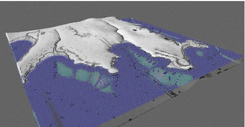
Fig. 1 A DSE terrain under construction in the game engine
The Digital Songlines Environment (DSE) uses a commercial middle-ware game engine to visualise the cultural landscape of individual indigenous Australian communities by placing cultural artifacts and stories within a virtual topographic reconstruction of the appropriate traditional lands. The design prioritises the cultural context of the communities through topologically accurate representation (Fig. 1). This endeavour intends to support a sense of being there, living that life. It aims to support an experience from which deeply cultural meanings of the environment as somewhere, a particular place, can emerge rather than remain terra incognita, offering the potential to recognise heterogeneity in such a cultural group and represent the actual traditional homelands in appropriate natural worlds. Thus, each iteration of the Songlines environment is developed closely with the traditional owners of the area reconstructed.
This multiple iteration approach is a critical recognition of the tendency to dichotomise Indigenous Knowledge systems (Nakata, 2002) against those of the Canonical western tradition, seeking in preference to represent the difference between tribal groups via place, via country as character. Such an emphasis on exact place via topographical representation also intensifies issues discussed here and inspires the design response described further on. The DSE iterations, made in a visualization engine, present a structure that is not easily transformable (Freire, 1972) by the memory holders who communicate their experience to the design team of programmers, level editors and animators.
The basic simulation is constructed carefully and as accurately as possible using Digital Elevation Models (DEM), topographic surface represented via Cartesian coordinates. The map is then given texture and mood by using photographic data taken from life. This ‘canvas’ is then populated with flora, again constructed from photographic data. Trees, bushes, grasses are all placed in the map according to communicated memories of the area and known ecology. Effectively, life is given to the landscape via simulation and embedding as much visual and audio detail as possible. The simulation strives for the ‘Ultra Real’ in order to speak to experience and create that sense of ‘living that life’.
However, the endeavour to construct a view from elsewhere and present that re-experience, to communicate this same nuance to those who are not party to the culture, raises some interesting issues, particularly that of cultural expectation and lens, Bolter and Gromala’s ‘mirror’. Thus the stories of the participant communities are mediated first by the design team who need to implement in a manner in which the engine can cope, and then by other players who look for their own stories when presented with a representation of an actual location. It is notable that a player in one iteration of the DSE which reconstructs the traditional lands of the Cadigal, the area of Sydney Harbour, wandered the virtual terrain trying to reconstruct the locations of current city landmarks in the pre colonial landscape.
3.1
"For now we see through a glass, darkly."
Memories and the small stories of lived experience are not easily abstracted into software design, with its methodological legacy of rationalism in elevating the mind over the body (Coyne, 1995). Key to this discussion is the manner in which the digital world is both a representation and a navigable environment, a window and a mirror. Representations of landscapes have evident parameters in that they are not the actual landscapes, they are surrogates, material objects with their own material properties (Casey, 2002). Representation within the navigable, interactive worlds of game engines mean that we can attempt a sense of the isomorphic but the relationship of the interactant to the representation is coerced by the material tendencies of the medium and the design habits of transparency.
Thus the Indigenous cultural heritage world described also uses devices offered by the game engine according to established game world conventions to support navigating the terrain. For example, ‘Heads Up Displays’ (HUDs) which are typically used in games to show inventories, health and location etc. This temptingly convenient extrinsic view detaches the world from the visitor. Moreover, it informs the visitor to Songlines that they are still a player in a game, a tourist who beyond the magic circle of the game will remain unaffected and who can affect the world only in the way designed. HUDs as interfaces are another layer between the explorer and the world; much like using a map or a GPS in the physical world this spatial abstraction exerts a particular interpretation of moving in the space and accordingly, maintains a particular perspective or view. Flynn attends to this western emblematic spatiality, for example the way linear perspective in Euclidean space emerged for a visualization to be “looked at” rather than actively engaged with via the legacy of enlightenment. Indeed, perspective means “seeing through” (Panofsky, 1991) rather than the concept of the view from elsewhere which implies “seeing with”.
Topological data in Songlines is generated from GPS co-ordinates. This extrinsic view of the world is tainted by historical antecedents in naval exploration and by contemporary socio-political power structures implicitly parceling and objectifying the world according to the perspective lens of Western culture (Black, 1997). Some liberties have been taken with this data to create a sense of actual world. For example, the edges of the world have been elevated along its boundaries, hiding the visibility of the edge of the digital map and creating a frame for the representation, thus emphasizing its material nature as a represented object (Casey, 2002). Further this data is then rendered in linear perspective, where the world’s geometry is inherently at the mercy of the player’s position in the world. The
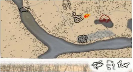
[image:4.612.324.553.148.272.2]game-world map currently used to construct the environment is also the result of legacies of rationalism and Cartesianism and associations with a history where maps are the weapons of colonialism, anticipating empire (Harley, 1998). A map option is again an aspect of standard game world strategies, be it a map that is exposed by the navigational activity of the player or a readily available overview of the whole world.
Fig. 2 DSE map – detail showing camp and options to view fauna locations
The player map in Songlines makes a brave effort at conforming with the aspects of the country important to the community. For example, the Yumba (camp) is marked as are kangaroo tracks through the bush but also spots where local creatures can be found and important bush tucker locations like a sugar bee nest. However, Australian indigenous maps are not the cartography exploited by the game engine, rather symbols such as concentric circles are used together to form a design, a pattern or Songline. These symbols describe rather than measure the landscape, showing special features with important mythological relevance to the subject matter depicted, they also tell stories instead of depicting sites and objects (Isaacs & Morrison, 1984). Such maps are mirrors, not the windows, measuring objects, of the western map, although all maps can be understood as mirrors of culture (Thrower, 1972).
4.
REPRESENTING PLACE
Layered on the Renaissance realism (Walther, 2005) of the simulation and interdigitated with topographic desires are modernist techniques to enable the interactant to explore the world as object of interaction. From one perspective Songlines may resist or subvert some of these implicit containments. For example, Songlines’ use of these spatial tactics may empower indigenous cultures with respect to contested places; just as Nietschmann says: More indigenous territory has been claimed by maps than by guns. This assertion has its corollary: more indigenous territory can be reclaimed and defended by maps than by gun” (1995). However, from another perspective access to a western-mode map undermines these spatial tactics and the depth of the experience as a view from elsewhere. Rather, like most of our modern maps, it confirms the particular somewhere of the viewpoint. It raises a challenge to the choreographers to find a way to enable direct implementation of the other’s viewpoint.
4.1
Landscape paintings, maps & virtual
topographies
No representation of landscape is isomorphic to the original, even if constructed to the exact scale with attempts at multi-sensory mechanisms; for example replicating wind and smell. Any physical world landscape is larger than the sum of its parts
·
..
,
(Casey, 2002) and objectifying a landscape dismantles its encompassing nature. Even a satellite image is flattened and removed into a framing site. Thus, in order to represent landscape, the designer or representer is faced with a choice of which aspect to represent within the frame of representation and medium of its surface. Choices on which aspect of landscape to represent are cultural; predicated by the emphasis of the society of the representation maker. The accuracy of physical representation and isomorphism of the landscape does not flesh out ‘character’ or sense of history. This resonates with the historical evolution of pre-digital landscape representation. This developed from being accessible only to those who share the context, (e.g. the medieval landscapes of symbols, see Clark 1949) through phases dominated by attempts to site the viewer in the shoes of the artist in the location by accurate topographical presentation, and then the more nuanced, evocative stages where the feel of the place depicted is seen as important.
Fig 3. Art work by Vincent Serico showing Indigenous map symbols (permission ACID art gallery)
A representation must always be a stand in – as Casey puts it: representations stand for. Such semiological entities subsequently include their own materiality, their own physical presence in the world. As material objects, representations become interesting; they are also objects of interaction. When discussing paintings, Casey observes that the materiality of the representation includes such situated aspects as the place of the exhibition of the representation, the site of its viewing. He also notices that any representation offers a surface and a medium of construction. Finally, such representations are framed in some way – paintings and pictures might be inside an actual frame, a codex presentation is framed by the materiality of the page, a computer based presentation is framed by the screen, no matter how large. Framed by the screen, a navigable world conforms to these constituents of representation and interestingly, the screen surface does often reflect as we look through its frame.
The materiality of the medium and the illusion of navigable space along with the interactional and navigation devices further site digital worlds as topographic representations, they are specific forms of representation: spatial visualisations that seek to interpolate between the users experience of the real world and the conceived understandings of space.
Harley describes spatial visualizations – maps - as mediators between the inner (mind) world and the outer world of the physically sited body, “helping make sense of the universe” (Harley, 1988). Map-like texts are ancient and widespread, preceding written language. They are also powerful cultural archives, serving “as memory banks for spatial data and as mnemonics for societies without printing”. They can be
understood as representation of Lefebvre’s perceived space in one of their functions: the representation of the visible, the practical – this river runs here. But a map also encompasses lived experience and spatial practice in the world. Even the most modern of maps will often refer to remains of the previous – old forts, roman roads and the like.
The history of our modern map concept has its roots in the portolan charts of the early European sailors who noted names of their way stages along a line which roughly corresponded to the shape of the coast they sailed along, and the cadastral maps of the Roman conquerors of Europe which show boundaries and land ownership. They present quite definitive views form somewhere. Models of space underpinning the representations constructed by contemporary western society to depict natural landscape are not neutral (Tuan, 1977; Harley, 1988). Consider how the prime meridian used today in GPS is the historical product of an infrastructure of global exploration and control with a perspective of the world based in the epistemic context of the enlightenment. Contrast this with Amazonian Indians view where along with longitude there is ”latitude, altitude, historical context, sacred sites, and spiritual or mythological sites, where invisible creatures mark watersheds and areas of high biodiversity as off-limits to exploitation” (Plotkin, 2006) or Tuan’s description of an Aivilik woman’s map where the world is defined by the location of trading posts (Tuan, 1977) or indeed a personal favourite, the stick charts from the Marshall Islands (Harvey, 1980) made of shells tied to fan like constructions of sticks. These are inconceivable as maps until the viewer understands that the primary directive is to understand the direction of currents relevant to an outrigger canoe traveling between the islands.
We have a tendency to append the term ‘accurate’ to maps which simulate our emphasis and understanding of the spatial world which surrounds us, without unpacking what the particular ‘accurate’ might be. Even the most modern map is an untruth of sorts. Large scale maps are forced onto a flat plane and the particular view is omnipresent, an attempt to encompass and, once again, represent the encompassing world as a representation. Maps of smaller areas employ a variety of symbols to represent sites and features, for example we interpret tiny icons of trees as forest, and we do not demand correlation between each icon and an individual tree. Further to this is the tradition copyright protection device of imaginary lanes, the London A-Z includes tiny inconsequential alterations which act as evident disclosure if the maps are copied. In spite of this we see maps which do show views from elsewhere as artistic, perhaps quaint. For example, the early medieval T-O maps which show the known world from a theocratic perspective, placing Jerusalem at the centre of the world, or the fabulous maps of Cosmas Indicopleustes who depicted the world according to information in the bible. We can only assume, but Cosmas, whose name means ‘Indian Sailor’ also probably used early portolan charts in his journeys and in spite of representing the world in a box, a holy ark, was probably quite aware of the horizon and the curvature of the earth which is extremely visible at sea.
design response under development here: the Situationists were also renowned for using graffiti as a tool for social change.
5.
"SMASH THE MIRROR
3"
While physics engines and representational capabilities get richer and more real, our virtual worlds still remain behind the screen, they remain representations, no matter how isomorphic. One way out of this is to set about destroying the frame and replacing the surface of the screen with other interfaces, like the extraordinary claustrophobia enabled by Genevieve Staines’ Forth Lytton4
installation which represented images of the old fort to the viewer inside a small box which had to be crawled into. However, such installation approaches – like Casey’s painted landscapes; tend to include very specific sites of exhibition and are thus party to another very specific world view and process.
The challenge here is to enable the construction of a view from elsewhere within the constraints of the materiality of the medium. In addition, we seek a way of scaffolding such construction without the process of technology – of creating teams to make their own game engine based worlds – which is a valuable goal but which has the potential to disenfranchise many of the memory holders, the owners of small stories, from the process. Projects such as DSE depend on a form of consultative participation (Adnan et al., 1992) particularly from the elders of the community. This is a situation where the cultural stakeholders are consulted by external world producers. In this form, the world production team members are external agents for the most part who define design problems and solutions and attempt to modify them in the light of participants response. For example, the cultural experiential world described previously involved the knowledge holder in the construction of the content of the world, language and asset descriptions. She was also a major instigator of the placing of many in-world assets but the nature of the world building process meant that these assets were actually constructed by others and adjusted to the constraints of their model of world – environment building. Furthermore, such consultations are subject to interpretation. The following project descriptions offer a means by which some of this interpretation may be minimised, calling on a very ancient way of making a mark on the world.
5.1
Graffiti: marking place in the world
Here we are inspired by another ancient approach to leaving individual voice on the face of the physical world: the practice of graffiti. Graffiti, like map making also dates back to ancient times. It is often thought that many of the earliest surviving graffiti – in essence, scratchings on the walls, might actually represent spatial understandings (Smith, 1987) but such scratchings are problematic to define as, significantly, the context of their making is long lost. The earliest graffiti as voice is found on the walls of Pompeii. Fresh graffiti is often a problem but the longer it lasts the more valued it becomes, witness the Viking graffiti left on the walls of burial mounds in the Orkney Islands and the now carefully preserved walls of a renovated Brisbane power station. Anyone who has ever visited a rainforest in South East Queensland will know that we like to leave some kind of mark on
3 Tommy: a rock opera (1969). Written by Pete Townshend 4 See Genevieve Staines, Gallery of Modern Art, QLD and:
http://www.qag.qld.gov.au/education/youth_programs/starter_s pace/Genevieve_Staines
the world – the bubble gum graffiti on trees in countless forest parks. This is something we have a tendency to do in the real and that the metaphor might be a useful way to approach the design of meaningful virtual landscape which even though they exist behind the screen, can be claimed in the same way that our offspring has claimed the footpaths near our house. At the time it was vandalism, now, several years down the track; it is a rather delightful sign of place in Tuan’s terminology.
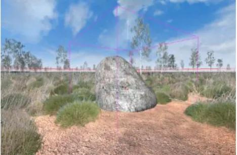
[image:6.612.321.555.159.312.2]Fig 4. Prototype drawable object within a game world We are in the process of “play-testing” the first prototype of our, loosely named “Graffiti Engine”, a project which integrates the perspective presented here with our research into corporeal and affective engagement and wayfinding in physical places (Bidwell & Browning, 2006; Bidwell & Axup, 2005; Bidwell & Graham, 2005). The engine enables participants to make their own markers in a digital representation of landscape and connect these with their own items or stories in a way that emphasizes the materiality of the real within the representation. For example, they can use representations of sharp stones to carve and organic dyes to paint trees and boulders and sticks to scratch sketches in the sand. Our design adds onto any existing world (constructed within a specific games engine at this stage) without requiring technical expertise in installation. Ironically, we have modified the game-engine’s default gun to create an invisible tool that when the user is proximal to a “drawable” object leaves a persistent trail of markings. A strong desire here is to lend pseudo substance to the represented objects within the world so that any current available pointer device might be exploited but that the result of the marking will maintain the coherence of the representation. The story-teller, perhaps someone like the aforementioned Gunggari Elder or a senior lady in a changing rural township, is able to draw on the world, now map. They can navigate the virtual and can select from a wide range of terrain features such as boulders, trees, sand on which to draw by transferring a graphic overlay, or decal, onto the appropriate terrain surface and fading the decal to transparent (see: Bidwell et al. 2007). Further to this, a direct extension of making the ground itself, the sand textures, a material surface is that the player can erode pathways across the digital environment and actually leave trails to the markers.
well as the small stories of us all. Such intangible knowledge should remain intimate to its holders, the Graffiti engine endeavours to allow them to say: “Here, in this place.” and to then make further connection with other media items that they might deem important, exploiting a naturalistic interaction device in the same way that such ‘scratchings’ have given voice to those outside official histories since ancient times.
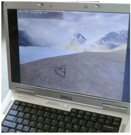
Fig 5. Marks left in the sand using the prototype engine
5.2
Memory in Places
The second thread of this endeavour to enable access and control over the representation exploits the use of mobile technologies; GPS enabled devices which can be used in-situ, in the country of representation. In an exploration of ways to “smash the mirror” and enable the views from elsewhere, this side of the project enables memory holders and story tellers to upload items they collect themselves (e.g. photographs, audio, video), using mobile phones, in their traditional lands into a topographical simulation; and, then to associate these items with their own hand-drawn markings in the simulation. Increased participation in Geographic Information Systems (GIS) enables diverse communities to interact with economic forces and governing authorities by describing the places in which they reside. In an increasing range of initiatives formerly marginalized people use Global Positioning Systems (GPS), data on the Internet, GIS, aerial photographs, satellite or remotely sensed imagery to promote their issues and concerns. As with the Graffiti Engine this thread arose from the collaboration of perspectives (see: Bidwell et al., 2007).
The device is not intended to replace high resolution capture for the purposes of 3D modeling, rather it exploits a variety of current commercially available mobile devices in order to create a participant interface that a group of schoolchildren could exploit on a walking the country trip with an elder, thus emphasizing the connection of the landscape to the walkers without the visible coercion or need to record everything in the formal mode. Basically such a device would add a generative element to the representation, it would enable the client communities to go and collect their own stories directly, rather than depending on translation by a design team. This has obvious potential for translation into more formal data-base software. It also has
potential for implementation into the simulated environment generated in the game-engine; enabling a reasonably seamless pipeline between the actual place as perceived by participants, the memory holders, and the virtual re-enactment of the place within the representation.
6.
REFLECTIONS & DIRECTIONS
Claiming place and voice is a problematic venture, even in virtual representations of the world. Witness the recent discussions and reaction to the making of a known place (his school) as a game mod for Counter Strike by an American high school student. However, claiming place is a vital critical venture, it is a powerful activity as evidenced by the ongoing practice of participatory GIS, which enables, not just production of a map, but ownership of the map and views from elsewhere. Game worlds have the potential to “be more about emotion and more about the emotion of where you are and what you are doing.” (Molyneux, 2005) As the team from Escape from Woomera put it:
"The videogame is the most rapidly evolving, exciting, subversive and feared cultural medium in the world today. It's akin to graffiti on the cultural landscape."
7.
ACKNOWLEDGMENTS
We thank CyberDreaming and The Indigenous Communities Project for The Digital Songlines Project supported by ACID (the Australasian CRC for Interaction Design) along with the indigenous communities who contributed to the DSE iterations, particularly members of the Gunggari. We thank Michael Shay for his programming and problem-solving in creating the Graffiti Engine prototype. We also thank Jason Holdsworth and Colin Lemmon in Cairns Discipline of IT at JCU involved in the project and Daryl Poyner of Redbackgames.com who has enabled us to use his gameworld for further testing. This work was partially supported by a Teaching & Learning Grant at JCU.
8.
REFERENCES
[1] Abel, E. and Buckley, B. (1977) The Handwriting on the Wall: Toward a Sociology and Psychology of Graffiti. Westport, Connecticut: Greenwood Press
[2] Bidwell, NJ & Axup, J (2005) The Territory is the Map: Exploring the Use of Landmarks in Situ to Inform Mobile Guide Design Proc. Xth Int. Conf. on Human-Computer Interaction (INTERACT05) IFIP & Springer-Verlag: Lecture Notes in Computer Science
[3] Bidwell, NJ & Graham C (2005) Daisy-Chaining & Berry-Picking: Trajectory Oriented Design for Mobile Guides in the Wild MobileHCI05 International Workshop on Mobile Guides
[4] Bidwell, NJ & Browning D (2006) Making There: Methods to Uncover Egocentric Experience in a Dialogic of Natural Places Proc. OzChi06, Sydney Australia (2006)
[5] Bidwell, N, truna aka j.turner, Holdsworth, J. Lemmon, C. & M. Shay (2007) Heritage & Habitus: Designing to Support Situated, Living Knowledge, Mobile HCI 2007, Singapore [6] Black, J. (1997) Maps and Politics, Reaktion Books Ltd.,
London
[8] Casey, E. S. (1993). Getting Back Into Place: Toward a Renewed Understanding of the Place-world. Indiana University Press.
[9] Casey, E. S. (2002). Representing Place: Landscape Painting and Maps. University of Minnesota Press. [10]Clark, K. (1949). Landscape into Art. J. Murray London [11]Coyne, R. (1995). Designing Information Technology in the
Postmodern Age: From Method to Metaphor. MIT Press. [12]de Certeau, M. (1984). The Practice of Everyday Life. Trans
Steven Rendall, University of California Press Berkeley, CA. [13]Dourish, P. (2006). Re-space-ing Place:" Place" and" Space"
Ten Years on. Proceedings of the 2006 20th anniversary conference on Computer supported cooperative work, 299-308.
[14]Flynn, B. (2006). Imaging Gameplay--the Design and Construction of Spatial Worlds. Paper presented at the Imaginary Worlds Symposium, UTS, Sydney.
[15]Freire, P (1972) Pedagogy of the oppressed, Penguin Books [16]Harley, J. B. (1988). Maps, Knowledge, and Power. The
Iconography of Landscape, 277-312.
[17]Harvey, P.D.A. (1980) The History of Topographical Maps: Symbols, Pictures and Surveys, Thames & Hudson, London [18]Huizinga, J. (1924). The Task of Cultural History in Men and
Ideas: Essays on History, the Middle Ages, the Renaissance. Harper Torchbooks.
[19]Huizinga, J. (1938). Homo Ludens: A Study of the Play-Element in Culture, Boston, MA: Beacon Press, 1971 [20]Isaacs, J., & Morrison, R. (1984). Australia's Living
Heritage: Arts of the Dreaming. JB Books.
[21]Jenkins, H. (2004) Game Design as Narrative Architecture, in Noah Wardrip-Fruin and Pat Harrigan (eds.) First Person: New Media as Story, Performance, Game, Cambridge: MIT Press
[22]Lefebvre, H, (1991) The Production of Space, Blackwell, Oxford
[23]Merleau-Ponty, M. (2002) Phenomenology of Perception. Routledge
[24]Molyneux, P. (2005). Postcard from GDC. Game
Developer’s Conference, Gamasutra Retrieved 22 Feb, 2007, from
http://www.gamasutra.com/gdc2005/features/20050309/post card-kane2.htm Molyneux actually uses the expression: hyper-hyper real in his talk but it has subsequently been discussed as ‘Ultra Real’
[25]Manovich, L. (2001) The Language of New Media, MIT Press, Cambridge Mass, USA
[26]Munn, N, (1996) Excluded Spaces: The Figure in the Australian Aboriginal Landscape, Critical Inquiry 22 446-465.
[27]Nakata, M. (2002). Indigenous Knowledge and the Cultural Interface: Underlying Issues At the Intersection of
Knowledge and Information Systems. IFLA Journal, 28(5-6), 218-221
[28]Nietschmann, B. (1995). Defending the Miskito Reefs With Maps and Gps: Mapping With Sail, Scuba, and Satellite. Cultural Survival Quarterly, 18(4), 34-37.
[29]Oliver, J. H. (2001) Polygon Destinies: the Production of Place in the Digital Role-playing Game. Proceedings of the First Conference on Computational Semiotics for Games and New Media (COSIGN) 2001, 67-73.
[30]Panofsky, E. (1991) Perspective as Symbolic Form. trans C. S Wood, Zone Books.
[31]Plotkin, M. (2006). Cited in Butler, R. 2006, Amazon Conservation Team Puts Indians on Google Earth to Save the Amazon. Mongabay News, Nov 14, 2006, Available: http://news.mongabay.com/2006/1114-google_earth-act.html [32]Rose, D. B. (1996). Nourishing Terrains: Australian
Aboriginal Views of Landscape and Wilderness. Australian Heritage Commission.
[33]Smith, C.D. (1987) Prehistoric Maps and the History of Cartography, in Harley, J.B. & D. Woodward (eds) The History of Cartography, Volume I, University of Chicago Press, Chicago & London.
[34]Stockburger, A. (2006). The Rendered Arena: Modalities of Space in Video and Computer Games. Unpublished PhD, University of the Arts, London.
http://www.stockburger.co.uk/research/abstract.html [35]Suchman, L (2003) Located Accountabilities in Technology
Production, published by the Centre for Science Studies, Lancaster University, Lancaster at
http://www.comp.lancs.ac.uk/sociology/papers/Suchman-Located-Accountabilities.pdf
[36]Thrower, N.J.W. (1972) Maps and Man, Prentice-Hall, New Jersey.
[37]truna aka j.turner (2006) Destination Space: Experiential Spatiality and Stories. In Proc. Joint International Conference on CyberGames & Interactive Entertainment 2006, Perth, Australia.
[38]truna aka j.turner, Browning D & Bidwell NJ (2007) Wanderer Beyond Gameworlds. In Proc. of Digital Arts & Culture DAC2007, Perth, Australia
[39]Tuan, Y. F. (1977). Space and Place: the Perspective of Experience. University of Minnesota Press.
[40]Walther, B.K. (2005). Space in New Media Conception--with Continual Reference to Computer Games and Game Graphics. Paper presented at the 8th World Multiconference on Systemics, Cybernetics, and Informatics, Orlando, Florida.
9.
WORKS
[1] Crysis (2007) Crytek
[2] Fable 2, (2008), Lionhead Studios [3] Myst, (1993), Cyan Inc
[4] Resistance: Fall of Man (2006), Insomniac Games [5] Second Life, (2003), Linden Labs