Further Hydrogeological Investigations of
the Mill Creek - Kansas Creek Area,
Northern Tasmania
Abstract
Surface exploration has revealed three additional karstic streamsinks on the lower slopes of Western Bluff All appear genetically related to Croesus Cave, but today discharge their base flow to the more recently evolved Tailender Cave Spring. This is despite the fact that one streamsink lies only 100 m from Croesus Cave. Drainage from Blue Lake, a sinkhole pond, has been traced into Rat Hole Cave, and the connection from that cave to Tailender has been confirmed. Aquaduct Swallet probably drains directly to Tailender, 345 m lower and 3.6 km distant. A major extension has also been discovered in Rubbish Heap Cave, source of the stream that discharges from Lynds Cave, but from which drainage connections to Croesus under high discharge conditions have previously been hypothesised. These data compound the evidence for the existence of a major integrated karst drainage system and a high probability of inter flow between some of the components under high discharge conditions. The highest level of protective management is warranted for this very important complex.
Introduction
Ordovician limestone that crops out between the Mersey River and the lower slopes of Western Bluff (about 1400 m altitude) at the western end of the Mole Creek karst area has long been known to contain three major outflow stream caves (Figure 1). Tailender Cave (305 m altitude) lies at the upstream boundary of the limestone in the Mersey
K. Kiernan!, R. Eberhard! and C.H.C. Shannon2
! Forestry Commission, Tasmania 2Northern Caverneers Inc., Launceston, Tasmania
Valley and has been explored for more than 0.5 km. It appears to be the former outlet for a spring that now discharges directly into the bed of the Mersey River outside the cave, but the cave itself now serves as an overflow conduit. Just under 1 km down the Mersey Valley lies Croesus Cave (305 m altitude) in which 2 km of passages have been mapped, many of which are of large size and spectacularly decorated with speleothems, notably flowstones (Photo 1). This cave discharges about 10 m above river level and is the largest of the three outflow caves, despite the fact that under normal flow conditions it contains by far the smallest stream. Lynds Cave (290 m altitude) lies a further 650 m down the Mersey Valley, and presently contains the largest underground stream. It is also a spacious cave and has been explored for more than 1 km.
This paper reports new investigations of karst in the area: water-tracing experiments in the Tailender Cave - Croesus Cave area; investigation of the water chemistry and related aspects of Croesus Cave; and the exploration and mapping of a major new extension in Rubbish Heap Cave, source of the stream that flows through Lynds Cave.
surrounding landscape and patterns of past climatic change. Some of the caves contain evidence of multiple phases of sedimentation and re-elaboration, probably over hundreds of thousands of years, that are related to phases of relative instability and stability in the surrounding landscape during late Cainozoic glacial and interglacial climatic stages (Jennings 1967; Kiernan 1984, 1990a; Spate and Holland 1990). Radiometric dating and stable isotope analysis of stalagmite samples from Lynds Cave have also produced a sensitive record of temperature change over the period 12 600-2 800 years BP (Goede and Hitchman 1983). More recently Goede and Vogel (1991) have analysed variations in trace element composition in another dated stalagmite from this cave and have shown that trace elements can also provide important information about environmental change. These records are of intrinsic interest and of relevance to current concerns regarding possible warming of the planet by the Greenhouse Effect. Study of
more recent cave sediments is providing information relevant to a better
understanding of natural hazards in karst areas, such as the sudden formation of cover collapse sinkholes (Kiernan 1989b, 1990b; Kiernan et al. 1993). Rimstone pools in Croesus Cave have been single'd out as outstanding examples of this type of speleothem (Jennings 1971, 1985). More recently discovered clastic speleothems in Rat Hole Cave are of national significance (Kiernan 1989a) while the whole area has recently figured prominently in an international text on karst hydrology (Kiernan 1992). The caves are also an important recreational venue, their possible potential for development for tourism having long been recognised.
Protection of these various values demands an adequate understanding of the cave catchments since caves are continuously interactive with water and many of the natural processes within them need the
Photo 1. Speleothems in Croesus Cave. (Photo: Andrew Briggs)
T.s AS Q
Trimmer C.
Execution Poi~~ 41 °35'
[image:2.825.476.751.33.263.2]o
Figure 1. Relationships between karst phenomena and base flow underground drainage routes demonstrated by water-tracing experiments, The present land tenure in the area is superimposed:
CR = Croeslis Cave State Reserve; SF = State forest; WHA = World Heritage Area; MR
=
Marakoopa Cave State Reserve; PL=
private land.maintenance of natural stream and seepage flow regimes and water chemistry. Determining drainage routes in karst areas is not straightforward since underground streams commonly ignore the dictates of the surface topography, sometimes sinking underground into inaccessible cave systems to rise again in another valley altogether. Hence, valleys conspicuous on air photographs and maps often give a totally misleading impression of the drainage. Catchment disturbance, vandalism in the caves, the impact of careless visitors
underground, the theft of stalactites and other speleothems, and public safety, are among the issues that demand management responses (Kiernan 1984, 1989c; Spate and Holland 1990).
Land tenure and conservation status
In 1972, the Croesus Cave State Reserve was proclaimed over the outflow entrances of Croesus Cave and Lynds Cave. However, it
Croesus and Tailender Caves was
recommended for inclusion in the WHA in a report by the Department of Parks, Wildlife and Heritage, Tasmania (Dixon 1990). The total area was recommended for protection in the report of the Balanced Panel of Experts compiled during the Forests and Forest Industry Strategy process (Podger et al. 1990) and has the status of Deferred Forest under the Public Lands (Administration and Forests) Act 1991.
Despite the presence of a gate on the outflow entrance to Croesus Cave where the
Department of Parks, Wildlife and Heritage had for many years sought to administer an access permit system, two other unmanaged entrances on State forest continued to allow access. Gates were placed across these entrances by the Department of Parks, Wildlife and Heritage, with assistance from the Forestry Commission, Tasmania, in 1990. A map of Croesus Cave was prepared for the Forestry Commission, Tasmania, by P. Jackson that year as part of the Tasmanian Karst Atlas project which is being funded by the Tasmanian Forest Research Council. The Forestry Commission, Tasmania, also commissioned a major management study of Croesus Cave (Spate and Holland 1990). Some minor in-cave management works were undertaken in Croesus Cave, in 1992-93. This involved some cleaning of muddied speleothems, litter removal and the marking of desirable access routes to reduce
inadvertent damage being caused by visitors.
Study of cave sedim~nts undertaken in collaboration with the Australian Nuclear Science and Technology Organisation at Lucas Heights, New South Wales, has recently added to earlier circumstantial evidence that past logging activity has led to water chemistry and sediment flux changes injurious to some of the caves and natural values of the karst system generally (Kiernan et al. 1993). This evidence of adverse impacts in the caves from activities on the surface has highlighted the need for improved understanding of drainage relationships in the area.
Tasforests 1("1
Underground drainage
This study focusses on an area bounded in the north by the catchment of Kansas Creek, to the south by the catchment of Mill Creek, to the east by Western Bluff and to the west by the Mersey River. A further pronounced valley, formed by Vanishing Creek, descends from Western Bluff between Kansas Creek and Mill Creek. All the water that flows into this area sinks into the limestone, with the exception of Mill Creek which, at about 380 m altitude, flows onto older non-carbonate rocks that underlie the limestone. This geological boundary cuts off any underground drainage down the lower Mill Creek Valley. It
probably deflects towards Tailender Cave any seepage that has occurred into the limestone further upstream along the Mill Creek Valley.
The most conspicuous surface karst feature in the area is a large compound, enclosed depression or uvala of about 0.8 km2, closed below about 395 m altitude. This uvala is broadly V-shaped and comprises two principal axes and numerous smaller sinkholes. The northern axis continues the westward orientation of the Kansas Creek Valley downstream of the point at which that stream sinks into the limestone via Rubbish Heap Cave. This axis terminates 850 m beyond Rubbish Heap Cave in a sinkhole that contains two further cave entrances, April Fools and Top Hole, that give access into the upstream end of Croesus Cave. The southern axis of the uvala is a narrow corridor 100 m wide that extends 1100 m north-westward from just above the point at which Mill Creek flows off the limestone. It originates as a fossil stream channel formed on the northern margin of an alluvial fan deposited by Mill Creek, while downstream it also converges on the upstream area of Croesus Cave.
The relationship between Croesus Cave, the axes of the uvala and the valleys that descend from Western Bluff suggest that all these streams have at various times contributed water to Croesus Cave. This is consistent with the presence of fossil sediments in Croesus Cave that indicate it has previously
contained a large and vigorous stream, and with the very large dimensions of the main stream passage in that cave. However, the present day drainage patterns in the area are far more complicated than the surface topography suggests.
Previous studies (Kiernan 1984, 1989c, 1992) have shown that Vanishing Creek, which sinks at about 530 m altitude, travels via Rat Hole Cave to the Tailender Spring. The stream that discharges from Lynds Cave has been shown to originate from Kansas Creek, which sinks into Rubbish Heap Cave (400 m altitude) at high stage, or into the creek bed several hundred metres upstream, and up to 20 m higher than the cave when the stage is lower. Rubbish Heap Cave is generally blocked by clastic debris about 50 m inside its entrance, precluding exploration of the passages that extend towards Lynds Cave. Despite a relatively modest gradient of only about 46 m/km over the linear distance of 2.4 km between Rubbish Heap Cave and Lynds Cave, the tracer flow-through time under high stage conditions when the drainage connection was proven implied a staggering water velocity of more than 2000 m/hr, much faster than any of the rates recorded in the contemporary international texts on karst hydrology by Jennings (1985) and Ford and Williams (1989). This
suggested the existence of a major, large and open, cave passage in the hitherto unexplored part of this system.
Given the absence of any major surface stream to account for the stream now present in Croesus Cave, it has been assumed to originate from percolation water and gradual release from groundwater storage in glacial, colluvial and alluvial sediments that locally mantle the limestone. The entrance to Rat Hole Cave is located in the central part of the southern axis of the uvala. In recent years, the discovery of several hundred metres of previously unknown passage of impressive dimensions has facilitated access to an underground stream passage and water-tracing experiments utilising this cave. It was derisively named by its original explorers for its constricted and
tortuous upper level passages that were the only part of the cave known for several decades. The discovery that the Rat Hole stream drained to Tailender was unexpected, given that Rat Hole lies in the uvala only a few hundred metres distant from April Fools and Top Hole. The main pa'ssage of Tailender Cave carries water only under high flow conditions. An older, upper level passage contains large dolerite boulders in a matrix of silt and clay. The active stream flows through a conduit a few metres below the level of the main passage and has been entered but not fully explored by cave diving (P. Cover, pers. comm.). Both Croesus and Lynds Caves are characterised by large suites of fossil clastic sediments, often embedded in speleothem carbonate that has been subjected to considerable paragenetic passage modification since its deposition. The Tailender system appears to be progressively pirating water that previously flowed to Croesus Cave (Kiernan 1984, 1990c).
Implicit in the genetic relationship between the caves that these facts imply is the possibility of older, higher level flow-path interconnections between the present baseflow conduits being reactivated under conditions of high stream discharge when the capacity of the presently evolving channels is exceeded. This is a consideration of major management significance since it means the various caves cannot be managed as if isolated from one another and a more holistic approach to catchment management is demanded.
Further investigations
flows to the Mersey River at the extreme southern margin of the limestone outcrop. Due to the limited likelihood of human access being gained into cave entrances in these two localities because of probable partial blockage by slope deposits, those areas had not previously' been the subject of serious scrutiny by recreational cavers, despite their fundamental importance for management of the popular caves downslope. The previous dearth of exploratory effort was also influenced by the fact that the Middlesex geological map sheet did not indicate the boundary of the limestone accurately, a point not detected until photogeological mapping was undertaken by C.H.C. Shannon some years ago.
Two previously unrecorded major streamsinks were located during the investigations by Northern Caverneers Inc. Blue Lake is a sinkhole pond 50 m in diameter a few hundred metres south of Vanishing Creek. No negotiable cave entrance was found there. Small sinkholes are also present 200 m to the north-east, together with another very small streamsink. Aquaduct Swallet lies at about 650 m altitude in a valley tributary to the putative main branch of Mill Creek, the latter proving to carry a very much lesser flow than the swallet. The cave was named for the remains of an old timber aquaduct that had been established to channel water across the sinkhole in which the cave is located and into the main Mill Creek Valley a short distance away to provide a supply to a sawmill that formerly operated near Rat Hole Cave. Planned further exploration and mapping was frustrated by fallen trees which blocked the cave entrance. Nevertheless, the discovery of Aquaduct Swallet was of major significance since it confirmed rumours of a cave close to Mill Creek and it represented the first major streamsink to be found between Vanishing Creek and the southern boundary of the limestone outcrop. Its presence also implied that the limestone extended further south than was indicated on published geological mapping for the area. Aquaduct Swallet also lay at a higher altitude than any other streamsink in the Mole Creek karst, about 345 m above any potential
outflow and hence possibly being one of the deepest cave systems in Australia.
In January 1993, a party of Sydney cavers from the Australian Speleological Federation discovered, and partially explored and mapped, a major extension to Rubbish Heap Cave. This cave is normally blocked by the clastic and organic debris which gives the cave its name. The debris includes sawn timbers that are suggestive of past logging activity having contributed to this blockage. The party managed to excavate a way past the choke and explored a major passage, surveying as they went but turning back after 0.5 km due to a shortage of time. At the point from which they retreated, they were in a large chamber, with no indication of the passage closing down. Unfortunately, remobilisation by the stream of the debris in the entrance chamber twice sealed the extension again before exploration and mapping could be completed. Shortly afterwards, a party from Northern
Caverneers Inc. located a deep natural shaft on the flank of the hill a short distance upstream of Rubbish Heap Cave, presumably descending into the conduit system
associated with the watersinks in the bed of Kansas Creek upstream from the cave. These developments were of particular significance since they confirmed the presence of a negotiable cave passage in this area if access could be gained through the debris choke.
Water-tracing experiments
In order to clarify some of the drainage relationships, three water-tracing experiments were undertaken: one using fluorescein as a tracing agent in the area of upstream Croesus Cave when stream discharges were at a moderately high level in November 1992; and two others using rhodamine WT from Aquaduct Swallet and fluorescein from Blue Lake (with assistance from members of Northern Caverneers Inc.) during Easter 1993. Stream discharges were low at the time, with no water flowing in the accessible part of Tailender Cave.
The first test investigated the destination of a small stream that sinks within 100 m of the known upstream end of Croesus Cave. At 20:30 hrs on 23 November 1992,500 g of fluorescein was injected into the stream just upstream of its sinking point. Despite periodic inspections of Lynds Cave, Croesus Cave and the Tailender Spring over the next two days, no visual evidence of fluorescein was obtained. However, an activated charcoal detector obtained from Tailender Spring on the morning of 25 November 1992 produced an elutant that fluoresced strongly in natural light. The elutant from detectors retrieved from Croesus Cave failed to reveal any sign of fluorescein under either natural or ultraviolet light. From this result it was concluded that despite the close proximity of April Fools and Top Hole, which lie in the same closed depression as the tested streamsink, the tested stream instead flows 1 km to Tailender Cave under the discharge conditions that prevailed at the time.
In the second experiment, 750 g of fluorescein was injected into a re-entrant into which water flow was visible on the margin of Blue Lake at 17:45 hrs, 9 April 1993. Monitoring was by periodic water sampling and charcoal detectors at the outflows from Tailender Spring, Croesus Cave and Lynds Cave, and in Rat Hole Cave. Pre-test samples were also obtained as controls for the fluorometric analyses. The creek in Rat Hole Cave became strongly coloured by fluorescein at some time between 20:00 hrs, 9 April 1993, and 23:30 hrs, 10 April 1993. The Tailender Spring became coloured by fluorescein after 17:15 hrs, 12 April 1993, and before (but probably not long before) 08:15 hrs, 13 April 1993. It remained strongly coloured until after 09:00 hrs, 14 April 1993. Hence this
experiment demonstrated that the Blue Lake stream joined Vanishing Creek upstream of Rat Hole, and it confirmed the drainage connection between Rat Hole Cave and Tailender Spring previously reported (Kiernan 1984).
In the third experiment, one litre of rhodamine WT was injected into Aquaduct
Swallet at 16:30 hrs on 9 April 1993. No visual observations of rhodamine WT were made at any site, possibly due to masking by fluorescein. Fluorometric analyses of water samples retrieved from Tailender Spring at 08:15 hrs, 13 April 1993, indicated the possibility of some tracer being present while strongly positive results were obtained from samples obtained from the spring at 08:00 hrs, 14 April 1993, and on 17 April 1993. A sample from a sump pool at the upstream end of Tailender Cave itself on 18 April 1993 also proved strongly positive. Charcoal detectors retrieved from Tailender Spring on 14 April 1993 and 20 April 1993 also tested strongly positive. These results demonstrated that Aquaduct Swallet formed part of the catchment of Tailender Spring and confirmed that the stream conduit that today feeds the Tailender Spring remains connected to Tailender by older passage systems.
Table 1. Discharge estimates for streams, 9-12 April 1983 (by velocity head method).
Stream Date Time (Ii tres / sec) Discharge
Aquaduct Swallet 9 April 1993 16:30 hrs 9.4
Blue Lake stream 9 April 1993 17:45 hrs 4.7
Vanishing Creek 12 April 1993 14:30 hrs 1.6
Mill Creek (old mill site) 9 April 1993 18:30 hrs 1.6
Rat Hole stream 10 April 1993 11:30 hrs 7.1
Tailender Spring 10 April 1993 13:30 hrs 18.9
Croesus stream (outflow) 11 April 1993 09:50 hrs 2.4 Lynds stream (outflow) 11 April 1993 09:20 hrs 56.6
at the time the test was conducted (Table 1) suggests those two streamsinks alone are virtually sufficient to account for the Rat Hole stream. Allowance must also be made for other minor contributions that are probably also made to the Rat Hole stream by seepage waters and presumably also the tiny flow that goes underground near the entrance of Horries Hole. If any water from Aquaduct Swallet does reach Rat Hole Cave, it can only be a very minor anabranch of the Aquaduct Swallet stream rather than its total discharge.
The results of this water tracing indicate that Vanishing Creek and the Blue Lake stream utilise essentially the same systems of cave passages to reach Tailender Spring rather than travelling via separate conduits. However, they imply that most of, if not all, the Aquaduct Swallet water travels to Tailender via a separate system from that which contains Vanishing Creek and the Blue Lake stream. Whether the stream that sinks near April Fools travels independently to Tailender or joins the Rat Hole stream can only be speculated upon at this stage. Given that it sinks in the same closed depression as that in which Rat Hole is situated, its confluence with the Rat Hole stream might seem probable. However, geographical proximity and surface geomorphology can be misleading as shown by the fact that in this area reliance upon them would lead to the erroneous assumption that both the un-named streamsink and the Rat Hole stream ought to be flowing to Croesus rather than Tailender.
Flow-through times determined during these experiments are presented in Table 2, together with the mean velocities indicated. For comparative purposes, the data derived from the tests performed in 1984, when discharge of the stream was greater, are also presented. It should be noted that the mean gradient figures are inevitably misleading since many of the stream systems probably descend steeply close to their streamsinks, with the remainder of the conduit being at a gradient very much lower than the mean. For example, Top Hole comprises a shaft system that descends essentially vertically for more than 40 m, and the mean gradient of the Croesus Cave streamway over the remaining 1.1 km linear distance to the cave outflow is probably no more than 30 m/km, and considerably less if the meandering of the stream passage is taken into account. The nature of the conduits plays a major role in conditioning flow-through times and water velocities, deep pools in particular serving to slow the flow. Despite the very steep gradient of the northern anabranch of Kansas Creek between Devils Pot and the Marakoopa Cave outflow, the flow-through time and implied velocity were slow compared to those in the lesser gradient conduits between Rubbish Heap Cave and Lynds Cave, albeit at higher discharge.
Discussion and conclusions
These hydrological studies and cave explorations have provided important new
f"",
2.F/o~'h"ogh
1"'= <md minim om,~_ ~Ioci,", ind"~'"
by~'~-"'dng
, _ - , (I
Distance Gradient
Segment (km) (m/km)
I
Un-named swallet trace 1992 swallet - Tailender
Aquaduct trace 1993 Aquaduct - ?Rat Hole?
Aquaduct - Tailender
Blue Lake trace 1993 Blue Lake - Rat Hole
Blue Lake - Tailender
Vanishing Creek trace 1984 Vanishing Ck. - Rat Hole Vanishing - Tailender
1.2 2.2 3.6 1.7 3.4 1.6 3.2 54.2 127.3 95.8 150.0 94.1 156.3 98.4
Kansas Creek (southern anabranch) trace 1984 Rubbish Heap C - Lynds 2.4 45.8
Kansas Creek (northern anabranch) trace 1990 Devils Pot - Marakoopa 0.7 200.0
insights into the karst hydrogeology of the area between Kansas Creek and Mill Creek, and proven the existence of a complex system of groundwater divides beneath the uvala when low discharge conditions apply. In broad terms, the results reinforce the evidence for genetic inter-relationships between the three drainage systems that today focus on Tailender Cave, Croesus Cave and Lynds Cave, and the critical importance of the Rat Hole system if the complexity and evolution of the system is to be fully understood. The limestone in this area is folded along axes that trend broadly NW-SE, and previous studies had shown this to be the predominant direction of underground drainage as subsurface conduits were developed along the strike of the limestone beds. The drainage in this direction is contrary to what might be predicted from the topography of the land surface, three underground breaches of surface drainage
Discharge moderate-high low low low low moderate moderate high moderately high Time (hr:min) < 35:30 > 31:00 <46:30 > 85:30 < 89:30 > 2:15 < 29:45
> 71:30 < 84:30
>3:45 >4:30
Velocity (m/hr)
> 31
< 71 >47 <42 >40
<756
> 57 <46 >40
<427 <711 < 27:30 > 116
1:10 2181
5:00 140
divides being involved. Glacial meltwaters, as well as local runoff, may have contributed to the genesis of cave passages in this area. The sequential development of the three outflows has been attributed to progressive incision by the cave streams as downcutting by the Mersey River has lowered the base level to which the systems drain, and more direct and efficient flow routes evolved in response (Kiernan 1990c). The results presented in this paper are consistent with this hypothesis. In particular, the position of the subsurface drainage divide between the Tailender and Croesus systems now
[image:5.826.80.372.58.168.2]Rat Hole C
Mill Ck
-
---
-Rubbish Heap C.
I
a km
Tatana Blue L. Magra Hidden C.
Harries H.
---"'
Harries Hole
a
a km
Tatana Magra
Aqueduct S.
km
800
600
400
E
800
600
400
E
=1
400
E
800
600
400
[image:6.828.399.794.61.445.2]E
Figure 2. Developed topographic profiles indicating the relative altitudes of components of the karst drainage systems. The extent of negotiable caves discovered and physically explored to date is represented schematically, together with the potential extent of hitherto unexplored caves implied by water-tracing results.
I
I
Table 3. Altitudinal differences and linear distances between cave entrances within subsystems of the Croesus Area karst hydrogeological system.
Altitude Altitude Distance Altitude Gradient
Cave entrance (m) Cave entrance (m) (km) diff. (m) (m/km)
From: To:
Aquaduct Swallet stream
Aquaduct 650 Tailender 305 3.6 345 95.S
Aquaduct 650 Rat Hole 370 2.2 2S0 127.3
Tatana Magra
Tatana Magra 630 Tailender 305 3.6 335 93.1
Tatana Magra 630 Rat Hole 370 3.6 270 75.0
Blue Lake stream
Blue Lake 625 Tailender 305 3.4 320 94.1
Blue Lake 625 Rat Hole 370 1.7 255 150.0
Rat Hole 370 Tailender 305 1.6 65 40.6
Vanishing Creek
Vanishing Creek 620 Tailender 305 3.2 315 9S.4
Vanishing Creek 620 Rat Hole 370 1.6 250 156.3
Hidden Cave 600 Rat Hole 370 1.5 230 153.0
Hidden Cave 600 Tailender 305 3.1 295 95.2
Horries Hole 500 Rat Hole 370 1.0 130 130.0
Horries Hole 500 Tailender 305 2.6 195 75.0
Rat Hole 370 un-named sink 370 0.65 0 0
un-named sink 370 Tailender 305 1.2 65 54.2
un-named sink 370 April Fools 3S0 0.2 10 50.0
Croesus
April/Top 3S0 Croesus 305 1.25 75 60.0
Kansas Creek (southern anabranch)
Rubbish Heap Cave 400 Lynds Cave 290 2.4 110 45.S
Kansas leaks 420 Lynds 290 2.5 130 52.0
Rubbish Heap Cave 400 Bull sink 4S0 0.3 SO 266.7
Bull sink 4S0 Lynds 290 1.9 190 100.0
Rubbish Heap Cave 400 April Fools 3S0 1.25 20 16.0
Kansas Creek (northern anabranch)
Devils Pot 600 Marakoopa 460 0.7 140 200.0
The results reported here also highlight the underground cave passage involved fact that even though this area is already generally far exceeds the simple linear known to contain some of the most celebrated distance between a streamsink and caves in Australia, considerable potential resurgence. For instance, the longest cave remains for further caves to be explored. The presently known in Australia, Exit Cave, demonstrated link between Aquaduct Swallet comprises some 20 km of passages developed and Tailender Cave spans a linear distance of over a linear distance of only 2.3 km between 3.6 km which makes it the longest proven the outflow and its most distant tributary underground drainage link in the Mole Creek streamsink. The potential for the exploration area (Figure 2, Table 3). The length of of very long integrated caves through the
o
[image:7.824.442.743.25.269.2] [image:7.824.66.362.33.259.2] [image:7.824.70.343.320.550.2]kilometre
Figure 3. Stream catchments and flow routes suggested by surface contours and assumption of drainage through the lowest saddle where depressions interrupt the thalweg of a valley. Compare with Figures 4 and 5. The upslope margin of the limestone outcrop (Og) is indicated by the hatched line but is commonly obscured on the ground by non-carbonate slope deposits.
146°16'
o
kilometre BASEFLOW CATCHMENTS
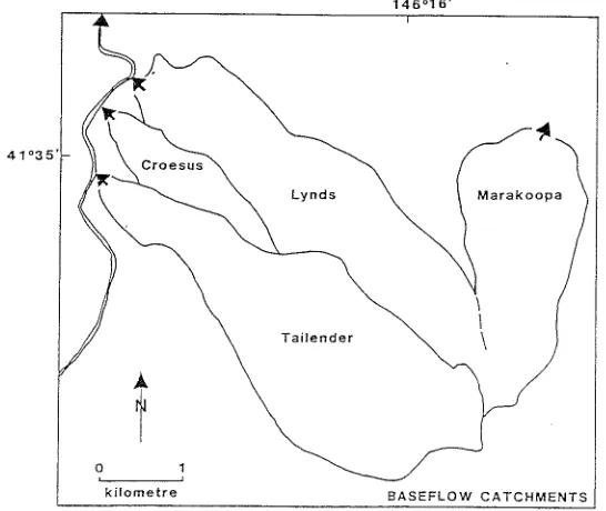
Figure 4. Baseflow catchments for the cave systems as interpreted from water-tracing experzments, geologzcal structure and topographic factors. Compare with Figures 3 and 5.
1
I
146°16'
Croesus \
\
\
t
o
kilometre
Figure 5. Catchment of Croesus Cave under very high discharge conditions. Some water from this area will also discharge via Mill Creek, Tailender Cave, Lynds Cave and Marakoopa Creek due to flow bifurcations under these conditions. The extent of the catchments exclusive to these latter streams when discharge is very high is also indicated.
linking of those parts of the complex
presently known is highlighted by the genetic relationships now known to exist, including the close proximity to Croesus Cave of caves now shown to contribute their present baseflow to Tailender, and other evidence discussed later for interflow between various caves under very wet conditions. The Aquaduct Swallet - Tailender Cave system also spans a greater altitudinal range (345 m) than any other karst system in northern Tasmania (Table 3). The four deepest caves presently known in Australia are 373, 371, 354 and 323 m deep; hence, this area theoretically has the potential to reveal a cave of nationally significant depth.
Given the great nature conservation
significance of the caves in this area, the very highest level of protective management is warranted. Long experience gained from around the world has made axiomatic among karst managers the absolute necessity to manage the surface catchments of any karst
cave as part of the cave itself if natural values of the caves are to be safeguarded. That the surface topography cannot be used to determine the extent to which
Accurate determination of underground drainage routes under high discharge conditions can be difficult due to access being precluded by flooded passages. Indeed, while collecting a detector from the Rat Hole stream during earlier research in this area in 1984, one of us was forced to 'roof-sniff back out through the main upper level passage after a pool on its floor, into which no water can be seen flowing, unexpectedly filled to within 3-4 cm of the ceiling during an absence of less than 15 minutes. The more recent work reported here has elaborated upon likely interflow processes and highlights the extent to which the adverse effects of disturbances in one area are likely to be transmitted to other areas during the types of high magnitude meteorological events that are the focus of most erosion and sedimentation in any landscape, even though some of those
~xtended catchments may not be recognised If water traCing is done only under drier conditions. However, detailed evidence of high discharge routes underground may often be derived more safely from geomorphological considerations or progressive, painstaking cave exploration over time under drier conditions than by water-tracing experiments under pressure during floods. In open stream passages, flood pulses move as kinematic waves that travel faster than the water itself, while flood pulses through water-filled conduits move as an almost instantaneous pressure wave that travels at the speed of sound (Ford and Williams 1989): at such times there are better places for a geomorphologist or caver to be.
Interflow, possibly overland, between Kansas Creek and upstream Croesus Cave had already been invoked to explain occasional flooding of the latter cave, which in one instance has been of sufficient magnitude to tear out the gate on its outflow entrance (Kiernan 1984). Were it not for the
intervention of Rubbish Heap Cave, Kansas Creek would flow to the lowest part of the uvala axis adjacent to April Fools, the present surface divide between the streamsink and uvala being no more than 5 m high. Given the location of the subsurface divide between
the Tailender and Croesus systems
demonstrated in the present study, the nature of the cave passages and the constraining topography at that point, interflow between these two systems under very high discharge conditions now seems inevitable. A report from a local resident of the main road having been cut in August 1970 by flooding of the depression between Rat Hole and upstream Croesus (Rod How, pers. comm., 22 April 1990) provides one instance in which such interflow must have occurred. Whether this might have involved bifurcation of Mill Creek around either side of an alluvial fan in its middle reaches also warrants consideration, since the local catchment may otherwise have been too small to generate a surface flow of this magnitude. The valley in which Rat Hole occurs originates as a fossil surface channel that extends from the apex of the alluvial fan and down its northern flank. Further evidence of overland flow into upstream Croesus Cave is provided by a 1.8 m thick bed of rounded gravels in a sandy matrix that occurs on the wall of a sinkhole adjacent to the April Fools entrance to Croesus Cave. A cave entrance in that sinkhole can be penetrated by humans for only a short distance but could easily accommodate a substantial flow of water. ApproXimately beneath this point in Croesus Cave lie ascending cave passages that are apparently clean-washed and associated with one of at least three upstream tributaries of the Croesus stream. Hence, at very high stage, much of the catchments of Kansas Creek Tailender Creek and Mill Creek probabl; contributes water to Croesus Cave (Figure 5).
The speleothems in Croesus Cave are extremely sensitive to water flow and water chemistry conditions. There has been mechanical damage to some of the rims tones by bedload gravels transported in recent decades by the stream that previously deposited finer chemical sediments instead. There has also been an evident change in the chemistry of the stream water from
conditions that facilitated construction of the rims tones to more aggressive water that is now dissolving the rimstones away (Spate and Holland 1990). Both imply significant
changes in the regime and chemistry of the stream in recent decades. Logging and roading are the only major disturbances that have occurred in the catchment. Thus, it would be extremely unwise to risk compounding these changes. In delicately poised karst systems, the potential exists for natural system thresholds to be crossed thereby triggering an evolution towards the establishment of a new equilibrium that may run its course long after the original
disturbance has ceased to play any direct part. Comparative isotopic studies of recent cave sediments have also added to the evidence for deleterious effects underground due to surface disturbance since the early 1950s (Kiernan et al. 1993). The streamflow regimes and water chemistry are the product not just of
conditions on the limestone outcrop itself, but also in the upper catchment on the slopes of Western Bluff. High magnitude-low frequency events such as major floods are major determinants of the geomorphological character of an area and often the major agents that effect geomorphic change. Hence, it is at the time that the very high discharge extended catchment of Croesus Cave is likely to become operative that the greatest risk is posed to this remarkable complex of caves. Of additional concern is the fact that this is also the time when the upper catchments are at greatest risk of landslide activity, already a recognised geomorphic hazard confronting forest management on the Great Western Tiers, and when resultant sedimentation problems are likely to arise in the streams that flow into the caves.
References
These conclusions beg the question of future land tenure and management of the area. This area is the only part of the Mole Creek karst that remains forested from the cave
catchments on the slopes of the Great Western Tiers to the system outflows on the Mersey River. The area became Deferred Forest because of a perceived need to obtain more information about the appropriate boundaries for protection, rather than any doubt regarding its nature conservation significance. While the area remains Deferred Forest it is potentially vulnerable to limestone quarrying at any time, to logging at some time in the future, and to other forms of activity injurious to its karst values. Most of the caves remain devoid of any form of protective management. The new investigations reported here all confirm the importance of the area for nature
conservation and its susceptibility to damage, and demonstrate the need to include the total catchment in the gazetted boundaries. The area should now be formally reserved.
Acknowledgements
We are grateful to Northern Caverneers Inc. for their exploratory efforts and to other members of the Australian Speleological Federation whose efforts resulted in the partial exploration and mapping of the extension in Rubbish Heap Cave, This paper stems from the Tasmanian Karst Atlas project funded by the Tasmanian Forest Research Council. Mick Brown and Albert Goede provided helpful comments on a draft of the manuscript.
Dixon, G. (1990). The Appropriate Boundaries of a World Heritage Area in Western Tasmania. Department of
Parks, Wildlife and Heritage, Hobart.
Ford, D.e. and Williams, P. (1989). Karst Geomorphology and Hydrology. London, Unwin Hyman.
Goede, A. and Hitchman, M.A. (1983). Late Quaternary climatic change: Evidence from a Tasmanian speleothem. In: Late Cainozoic Palaeoclimates of the Southern Hemisphere (ed. J.e. Vogel), pp. 221-232.
Balkema, Rotterdam.
Goede, A. and Vogel, J.e. (1991). Trace element variations and dating of a late Pleistocene Tasmanian speleothem. Palaeogeography, Palaeoclimatology, Palaeoecology 88: 121-13l.
Jennings, IN. (1967). Some karst areas of Australia. In: Landform Studies from Australia and New Guinea
(eds J.N. Jennings and J.A. Mabbutt), pp. 256-292. ANU Press, Canberra, and Cambridge University Press, Cambridge.
Jennings, J.N. (1971). Karst. AND Press, Canberra.
Jennings, J.N. (1985). Karst Geomorphology. Blackwell, Oxford.
Kiernan, K (1984). Land-use in karst areas: forestry operations and the Mole Creek caves. Unpublished report to National Parks and Wildlife Service, Tasmania, and Forestry Commission, Tasmania. Kiernan, K (1989a). Issues in cave and karst management. Australian Parks and Recreation 25(4): 28-32.
Kiernan, K (1989b). Sinkhole hazards in Tasmania. In: Engineering and Environmental Impacts of Sinkholes and Karst (ed. B.F. Beck), pp. 123--128. Balkema, Rotterdam.
Kiernan, K (1989c). Karst, Caves and Management at Mole Creek, Tasmania. Occasional Paper 22, Department
of Parks, Wildlife and Heritage, Hobart.
Kiernan, K (1990a). The extent of late Cainozoic glaciation in the Central Highlands of Tasmania, Australia. Arctic and Alpine Research 22: 341-354.
Kiernan, K (1990b). Soil and water degradation in carbonate rock terranes. Australian Journal of Soil and Water Conservation 3(4): 26-33.
Kiernan, K (1990c). Underground drainage at Mole Creek, Tasmania. Australian Geographical Studies 28(2):
224-239.
Kiernan, K (1992). Karst hydrogeology in Tasmania. In: Hydrogeology of Selected Karst Regions (eds W. Bach,
JS. Herman and H. Paloc), pp. 377-392. Verlag Heinz Heise, Hannover, FRC.
Kiernan, K, Eberhard, R.D. and Campbell, B. (1993). Land Management, water quality and sedimentation in subsurface karst conduits. Helictite 31(1): 3--12.
Northern Caveneers Inc. (1990). An inventory of the karst phenomena of the Mill Creek area. Unpublished report to Forestry Commission, Tasmania. (Includes an addendum, 19 February 1991.)
Podger, F.D., Bayly-Stark, L Brown, M.J., Delahunt, A, Kiernan, K., Kirkpatrick, J.B., Law, C.M., Ranson, D. and Richardson, AM. (1990). Report of the Panel of Experts of the Conservation Technical Working Group. Forests and Forest Industry Council, Hobart.