Proceedings of the Integrated Ocean Drilling Program, Volume 303/306
Background and objectives
Integrated Ocean Drilling Program Site U1313 constitutes a reoc-cupation of Deep Sea Drilling Project (DSDP) Site 607 located at the base of the upper western flank of the Mid-Atlantic Ridge in a
water depth of 3426 m, ~240 mi northwest of the Azores (Fig. F1).
Seismic air gun profiles indicate a prevalent sediment cover of
500–900 m above the acoustic basement in this region (Fig. F2).
Two holes were drilled at this site during Leg 94 (June–August 1983) using the variable-length hydraulic piston coring system and the extended core barrel system (Ruddiman, Kidd, Thomas, et al., 1987). Hole 607 penetrated to a total depth of 284.4 m and Hole 607A to a total depth of 311.3 m. The sediments recovered at Site 607 consist predominantly of calcareous biogenic oozes with variable amounts of fine-grained terrigenous material. The sedimentary sequence can be divided into two major lithologic
units (Fig. F3). Unit I, from 0 to ~116 meters below seafloor (mbsf)
(late Pliocene–Pleistocene), is characterized by cyclically interlay-ered intervals of dark sediment rich in fine-grained terrigenous material (silty clay foraminiferal-nannofossil ooze) and lighter colored sediment with relatively small amounts of terrigenous compounds (mainly foraminiferal-nannofossil ooze). Unit II, be-low ~116 mbsf (late Miocene–early late Pliocene), is composed of pale gray to white foraminiferal-nannofossil ooze and nannofossil ooze. Based on magneto- and biostratigraphy, the mean sedimen-tation rate at Site 607 is ~5 cm/k.y. for the Pliocene–Pleistocene time interval (Baldauf et al., 1987).
The rationale for reoccupying this site is essentially the same as
that for Site U1308 (recoring of Site 609; see the “Site U1308”
chapter). Together, Sites 607 and 609 constitute benchmark sites for the long-term (millions of years) as well as short-term surface and deep ocean climate records from the subpolar North Atlantic. Site 607, situated under the influence of North Atlantic Deep
Wa-ter (NADW) (Fig. F4), has been very important for generating
benthic δ18O, δ13C, and CaCO
3 records for the Pleistocene
(Ruddi-man et al., 1989) and late Pliocene (Ruddi(Ruddi-man et al., 1986; Raymo
et al., 1989, 2004) (Fig. F3) and for interpreting these records in
Site U1313
1Expedition 306 Scientists
2Chapter contents
Background and objectives . . . 1
Operations. . . 2
Lithostratigraphy. . . 3
Biostratigraphy . . . 6
Paleomagnetism . . . 13
Stratigraphic correlation . . . 14
Geochemistry . . . 15
Physical properties . . . 18
Downhole measurements . . . 19
References . . . 20
Figures . . . 24
Tables. . . 74
1Expedition 306 Scientists, 2006. Site U1313. In
Proc. IODP | Volume 303/306 2 shipboard capability for construction of composite
sections and pass-through magnetometers for con-tinuous measurement of magnetic parameters. Pale-omagnetic data from this site indicate that the mag-netic properties are optimal for recording the geomagnetic field. The present condition of existing DSDP cores collected in 1983 does not permit the high-resolution studies proposed here.
At the site of Core VM 30-97, located close to Site 607, Heinrich events are marked by a distinctive de-trital carbonate signature, providing a means of cor-relation to other Expedition 303 and 306 sites. Based on census counts of planktonic foraminifers, sea-sur-face temperature (SST) warmed markedly during the Heinrich events and during the Last Glacial Maxi-mum (LGM; 18 and 20 ka) in distinct contrast to the climate records from the subpolar North Atlantic (Bond et al., 1999b). This complex SST pattern, with respect to the subpolar North Atlantic, has now been traced from the early Holocene to Heinrich event 5 at ~46 ka. Recent coupled ocean-atmosphere models suggest that during full shutdowns of NADW pro-duction, likely during Heinrich events, complex pat-terns of SST may appear globally (Schiller et al., 1997) with antiphased warm anomalies appearing south of Newfoundland (Manabe and Stouffer, 1999). Reconstruction of SSTs in the North Atlantic indicates that the Polar Front was situated between ~42° and 46°N during glacial times, extending in an east–west direction and resulting in a steep south– north SST gradient (CLIMAP, 1976; Pflaumann et al.,
2003) (Fig. F5A). Alkenone SST estimates determined
in sediment cores from areas south of and within the Polar Front resulted in very different values for dif-ferent glacials (Fig. F5B) (Calvo et al., 2001), indicat-ing different climatic conditions (e.g., the location of the Polar Front) in these glacial periods.
Site U1313 (especially in combination with similar records from other Expedition 303 and 306 sites) will document the evolution of the complex surface tem-perature phasing over time, addressing questions such as whether the patterns are a peculiarity of the last glaciation, whether they were present in the 41 k.y. world, and whether they appeared at the onset of northern hemisphere glaciation. Antiphased pat-terns of ocean surface temperatures are documented in Core VM 30-97 for the 10–40 ka interval (Bond et al., 1999a). Redrilling Site 607 will provide a long-term record of this apparent antiphase pattern, which is now beginning to emerge in the western North Atlantic. By placing the surface temperature signals into a chronological framework based on a combination of oxygen isotopic stratigraphy, detrital carbonate-bearing Heinrich events, and geomagnetic paleointensity, we expect to obtain an optimal
re-construction of the phasing of the temperature records and their relationship to ice sheet instability and changes in deepwater circulation.
Operations
We departed the Azores Islands for Site U1313 (pro-posed Site IRD3A) at 0645 h on Saturday, 26 March 2005, after spending 8 days in the lee of the islands during severe weather conditions. The 277 nmi tran-sit to Site U1313 began with sea-state conditions still somewhat marginal but expected to continuously improve over time. The transit was completed at an average speed of 8.9 kt, and we arrived at Site U1313
at 1425 h on Easter Sunday, 27 March. See Table T1
for a summary of coring at Site U1313.
Hole U1313A
Hole U1313A was spudded at 0005 h on 28 March 2005, establishing a rig floor–corrected seafloor depth of 3423.3 meters below rig floor (mbrf). Core 1H recovered 5.2 m of sediment, indicating a sea-floor depth of 3412.3 meters below sea level. The ad-vanced piston coring (APC) system, utilizing non-magnetic core barrels, continued through Core 31H. Alloy steel barrels were utilized for Cores 32H and 33H, and drillover of stuck APC barrels was required for these last two cores. Tensor core orientation was used for all cores beginning with Core 3H from a depth of 14.7 mbsf. All core barrels fully stroked ex-cept for the last one, Core 33H. The cored interval for this hole was 308.6 m, and 319.64 m of sediment was recovered (recovery = 103.6%). The drill string was pulled clear of the seafloor at 1300 h on 29 March, concluding operations in Hole U1313A.
Hole U1313B
hole. Nonmagnetic core barrels were used in the re-covery of all 32 cores. The cored interval for this hole was 300.4 m, and 306.54 m of sediment was recov-ered (recovery = 102.0%).
After completing coring operations, Hole U1313B was prepared for logging. A wiper trip was conducted from total depth to 74.9 mbrf and back to total depth without difficulty. No fill, drag, or overpull was detected. The hole was swept with one final 30 bbl mud sweep, and the lockable float valve (LFV) go-devil was pumped down to lock open the LFV for the wireline logging tools. The hole was displaced with 140 bbl of sepiolite mud, and the drill pipe was retracted to 80.7 mbsf. The triple combination (triple combo) tool string was deployed (including the Gen-eral Purpose Inclinometer Tool and Multi-Sensor Spectral Gamma Ray Tool [MGT]) to within 2.0 m of the bottom of the hole. We successfully logged 220 m of the open hole and then the interval within the pipe to the seafloor. The scheduled deployment of the Formation MicroScanner (FMS)-sonic tool string was cancelled because the Lamont-Doherty Earth Observatory (LDEO) Logging Staff Scientist felt that the resistivity signal was too weak to make the de-ployment worthwhile. After recovery of the wireline tools, new software for the Schlumberger wireline heave-compensated logging winch was briefly tested. The software was tested for ~45 min under a variety of conditions, and the results appeared to be “very promising.” The Schlumberger logging sheaves were rigged down, and the drill string was pulled clear of the seafloor at 1310 h on 31 March, ending Hole U1313B.
Hole U1313C
The drillship was offset 25 m due east (90°) of Hole U1313B. The bit was positioned at a depth of 3417.0 mbrf, 2.0 m shallower than for Hole U1313A. Hole U1313C was spudded at 1440 h on 31 March 2005. Core 1H recovered 2.71 m and established a rig floor–corrected seafloor depth of 3423.8 mbrf. APC coring with nonmagnetic core barrels continued through Core 30H, and alloy steel barrels were used for the last two cores (31H and 32H). Tensor core ori-entation was used for all cores beginning with Core 4H from a depth of 21.7 mbsf. Drillover was required for recovery of Cores 29H through 32H. All core bar-rels fully stroked except for the last three (Cores 30H
Hole U1313D
The drillship was offset 25 m due south (180°) of Hole U1313C. The bit was positioned at a depth of 3423.0 mbrf, or 4.0 m deeper than for Hole U1313A. Hole U1313D was spudded at 2255 h on 1 April 2005. Core 1H was fully recovered (9.80 m); there-fore, the seafloor depth of 3423.0 mbrf was consid-ered suspect. A valid seafloor depth was not critical for this hole because good seafloor measurements had already been obtained on the three previous holes and the emphasis was to maximize recovery in Core 1H. APC coring continued without incident in Hole U1313D through Core 16H to a total depth of 152.0 mbsf. Tensor core orientation was used for all cores, beginning with Core 3H from a depth of 19.0 mbsf. All core barrels fully stroked, and no drillover was required. Nonmagnetic core barrels were used for recovery of all 16 cores. The cored interval for this hole was 152.0 m, and 159.27 m of sediment was recovered (recovery = 104.8%).
The drill string was pulled clear of the seafloor at 1310 h on 2 April, and during the pipe trip position-ing, beacon SN 2199 was recovered at 1430 h. After we recovered and stored the drill string, the ship was secured for transit, all thrusters and hydrophones were pulled, and at 2030 h, the ship was switched from dynamic positioning to cruise mode and got under way for alternate Site U1314 (proposed Site GAR1B).
Lithostratigraphy
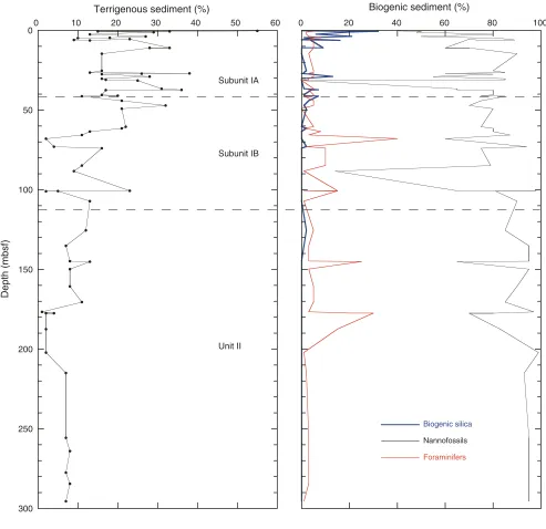
At Site U1313, a 308 m sequence of pelagic sediment was recovered in four holes. The major sediment is composed of nannofossil ooze with varying amounts of foraminifers and clay- to silt-sized terrigenous ma-terial. Major lithologies range from silty clay nanno-fossil ooze to nannonanno-fossil ooze, with minor foramin-ifer nannofossil ooze, silty clay nannofossil ooze with diatoms, and nannofossil silty clay. Smear slides indicate that noncalcareous sediment contains bio-genic silica, quartz, and clay and generally makes up
5%–40% of the sedimentary sequence (Fig. F6).
Sedi-ments recovered are generally undisturbed.
Lithologic units for the Site U1313 sedimentary se-quence are defined on the basis of data obtained from smear slide examination, visual observation of
sediment color, percent carbonate (see Fig. F27 in
Proc. IODP | Volume 303/306 4 each hole. It consists of upper Pliocene–uppermost
Miocene nannofossil ooze. Unit I can be further di-vided into subunits on the basis of changes in the percentage of and variability in clay and nannofossil
content. Figure F7 shows a summary of the
litho-logic units at Site U1313.
Description of units
Unit I
Intervals: Sections 306-U1313A-1H-1, 0 cm, through 13H-2, 66 cm; 306-U1312B-1H-1, 0 cm, through 13H-1, 88 cm; U1313C-1H-1, 0 cm, through 13H-4, 30 cm; and 306-U1312D-1H-1, 0 cm, through 12H-6, 114 cm Depths: Hole U1313A: 0–111.86 mbsf, Hole U1313B: 0–111.28 mbsf, Hole U1313C: 0– 112.00 mbsf, and Hole U1313D: 0–113.14 mbsf
Age:Holocene–late Pliocene
This unit represents deposition during the Ho-locene–late Pliocene. Dominant lithologies are silty clay nannofossil ooze, nannofossil ooze with clay, and nannofossil ooze, which are gray (5Y 6/1), light gray (5Y 7/1), and white (5Y 8/1 and N9). The unit is defined by centimeter- to decimeter-scale variability in detrital clay and biogenic carbonate with de-creased variability downcore. Lithologic variability occurs visually in the form of distinct cyclic color changes at centimeter to decimeter scale. This is re-flected by large-amplitude shifts in carbonate
con-tent (Fig. F27), as well as large variability in gamma
ray attenuation (GRA) density and magnetic
suscep-tibility and intensity measurements (Figs. F18, F32,
F35). Occasional millimeter- to centimeter-scale
dif-fuse bands of green and gray (5G 7/2 and N4–N5) are distributed throughout the unit. Boundaries between intervals are often gradational and bioturbated. In general, bioturbation/mottling is rare to moderate, and burrows up to 2–3 cm in size are mainly located across contacts between contrasting colors. Drop-stones frequently occur throughout Unit I (see be-low).
Subunit IA
Intervals: Sections 306-U1313A-1H-1, 0 cm, through 5H-5, 130 cm; 306-U1312B-1H-1, 0 cm, through 5H-4, 48 cm; U1313C-1H-1, 0 cm, through 6H-U1313C-1H-1, 38 cm; and 306-U1312D-1H-1, 0 cm, to 5H-2, 20 cm
Depths: Hole U1313A: 0–41.00 mbsf, Hole
U1313B: 0–39.38 mbsf, Hole U1313C: 0– 41.08 mbsf, and Hole U1313D: 0–39.7 mbsf
Age:Holocene–early Pleistocene
This subunit is characterized by the largest-scale am-plitude fluctuations in detrital clay and biogenic car-bonate in Unit I. This is reflected by distinct color
changes and shifts in both L* (Fig. F7), carbonate
(Fig. F27), GRA density (Fig. F35), and magnetic
sus-ceptibility (Fig. F32). The uppermost ~65 cm of the
succession is yellowish brown (10Y 5/4) and consists of nannofossil silty clay. This interval represents the Holocene, and the color is related to sediment oxida-tion due to circulaoxida-tion of oxygen-rich seawater. The remainder of the subunit consists of nannofossil silty clay, silty clay nannofossil ooze, nannofossil ooze with clay, nannofossil ooze, and subordinate inter-vals of silty clay nannofossil ooze with diatoms and nannofossil ooze with diatoms and clay. Color varies from white (N9 and 5Y 8/1) to light gray (5Y 7/1) and gray (5Y 6/1) with subordinate light olive-gray (5Y 7/2) and olive-gray (5Y 6/2). Color changes are usually gradational and bioturbated and reflect varia-tion in carbonate versus clay content. In general, bioturbation is rare to moderate. Typical abundance of biogenic and terrigenous components, as esti-mated from smear slides, are nannofossils (30%– 90%), clay (0%–35%), detrital calcite (0%–30%), de-trital quartz (0%–20%), diatoms (1%–10%), foramin-ifers (0%–10%), sponge spicules (trace to 10%), and radiolarians (trace to rare). Percent carbonate also displays the strong amplitude variability demon-strated by nannofossil ooze and detrital clay content (30 wt%) (Fig. F27).
Figure F8 shows an X-ray diffractogram with peaks
identified for minerals present in the carbonate-free fraction of Sample 306-U1313A-4H-2, 147–148 cm (27.17 mbsf). Relative intensity of peak heights from baseline indicates that the sample is dominated by detrital quartz. Other significant peaks are attributed to feldspar and clay minerals. Although no oriented glass slides were prepared from the clay size (<4 µm) fraction, the presence of clay minerals can be dis-cerned as significant from a number of prominent
peaks between 0° and 40°2θ. A broad peak from 4° to
8°2θ and a sharp peak at 20°2θ are characteristic of
biotite mica and vermiculite and muscovite mica,
re-spectively. A relatively strong peak at 12°2θ
corre-sponds to the 001 h-k-l plane for kaolinite. The pres-ence of biogenic silica is recognized from an
amorphous hump between 20° and 30°2θ.
Subunit IB
Depths: Hole U1313A: 41.00–111.86 mbsf, Hole U1313B: 39.38–111.28 mbsf, Hole U1313C: 41.08–112.00 mbsf, and Hole U1313D: 39.7– 113.14mbsf
Age:early Pleistocene–late Pliocene
This subunit consists of nannofossil ooze, nannofos-sil ooze with clay, and nannofos-silty clay nannofosnannofos-sil ooze. Overall, percent biogenic carbonate is higher in Sub-unit IB, whereas detrital clay content is lower. Both are defined by decreased variability. This is reflected
in reduced amplitude fluctuations of L* (Fig. F7),
per-cent carbonate (Fig. F27), magnetic susceptibility
(Fig. F32), magnetic intensity (Fig. F18), and GRA
density (Fig. F35). Colors vary from white (N9 and
5Y 8/1) to light gray (5Y 7/1) and gray (5Y 6/1), re-flecting decimeter-scale variation in clay and genic carbonate content. Typical abundance of bio-genic and terrigenous components, as estimated from smear slides, are nannofossils (60%–98%), clay (0%–20%), foraminifers (2%–10%), detrital calcite (1%–5%), detrital quartz (1%–5%), diatoms (trace), and radiolarians (trace).
Unit II
Intervals: Sections 306-U1313A-13H-2, 66 cm, through 33H-CC, 22 cm; U1312B-13H-1, 88 cm, through 32-CC, 9 cm; 306-U1313C-13H-4, 30 cm, through 32H-CC, 12 cm; and 306-U1313D-12H-6, 114 cm, through 16H-CC, 14 cm
Depths: Hole U1313A: 111.86–308.64 mbsf, Hole
U1313B: 111.28–300.67 mbsf, Hole U1313C: 112.00–293.45 mbsf, and Hole U1313D: 113.14–152.34 mbsf
Age: late Pliocene–latest Miocene
Unit II consists of nannofossil ooze of late Pliocene– latest Miocene age. The change from Unit I to Unit II is gradational over ~40 m. It is defined by a change toward higher values and a reduction in variability
of L* (Fig. F7) and is coincident with a downcore
re-duction of percentage detrital clay and an increase in percentage biogenic carbonate, as well as decreased
variability in both (see “Site U1313 smear slides” in
“Core descriptions”). The transition is coincident with a consistent change in central tendency in per-cent carbonate, magnetic intensity, and resistivity. Decimeter-scale color banding is no longer apparent, and consistently high carbonate content is reflected in coloration, which varies only in shades of white (5Y 8/1 and N9). Occasional millimeter- to
centime-In Unit II, bioturbation is rare to moderate when ob-served. Lack of color contrast in this uniform lithol-ogy makes it difficult to estimate the degree of bio-turbation, which may be totally bioturbated or homogenized. However, micronodules of pyrite are often present and likely located near burrows, and they may produce black streaks on the cut surface of the cores as a result of the core splitting process. Py-rite is also sporadically present in the form of burrow casts and nodules. Pyrite origin is probably related to local reducing conditions associated with organic matter complexes.
Foraminifer “event” beds
A number of millimeter- to centimeter-scale fora-minifer nannofossil ooze beds occur in both units.
Figure F9 demonstrates that the majority of these
beds can be correlated with variable thickness across all four holes. These beds typically have a sharp, oc-casionally erosive, pyrite-rich base and, most com-monly, gradational upper contacts. A number show normal grading. The most noteworthy of such layers is a decimeter-scale thick bed at 100.62–100.91 mbsf in Hole U1313A, 101.49–101.73 mbsf in Hole U1313C, and 103–103.29 mbsf in Hole U1313D (Fig.
F10; Table T2). An equivalent layer was not observed
in Hole U1313B and is shown to have been lost in a core break. The layer displays normal grading with a scour at the base and has been interpreted as a turbi-dite. It is not certain if all of these beds are the result of deposition by turbidity currents, although they probably represent reworked material.
Ash beds
A prominent ash layer was identified at 32.97–33.02 mbsf in Hole U1313A, 32.62–32.34 mbsf in Hole U1313B, 32.68 mbsf in Hole U1313C, and 32.85–
32.86 mbsf in Hole U1313D (see Figs. F9,F11). It is
associated with a large positive magnetic
susceptibil-ity anomaly (see “Physical properties”). Smear
Proc. IODP | Volume 303/306 6 grains are interpreted as ice-rafted debris (IRD).
Cor-relations can be made between regular intervals of IRD in meters below seafloor across all four holes in Unit I. Preliminary analysis of these dropstones shows that they typically range in size from 2 to 10 mm but can be as large as 30 mm, especially in sedi-ments of Subunit IA. Only two gravel-sized grains were found in Unit II. A millimeter-scale carbonate clast at 157.27 mbsf in Hole U1313A (Section 306-U1313A-18H-1, 7 cm) has been attributed to core flow-in and is not in situ. A 30 mm clast of basic ig-neous origin occurs at 176.32 mbsf in Hole U1313A (Section 306-U1313A-20H-1, 12 cm). Given its loca-tion at the top of Core 306-U1313A-20H, it also may not be in situ. Two of the most prominent events of
increased IRD input are shown in Figures F12 and
F13. Subangular to subrounded carbonate
gravel-sized grains occur in a decimeter-scale interval of silty clay nannofossil ooze at 57.60–58 mbsf in Hole U1313A (interval 306-U1313A-7H-4, 20–60 cm), 57.50–57.90 mbsf in Hole U1313B (interval 306-U1313B-7H-3, 110–150 cm), 58.65–59.15 mbsf in Hole U1313C (interval 306-U1313C-7H-6, 95–145
cm) (Fig. F12), and 57.54–57.90 mbsf in Hole
U1313D (interval 306-U1313D-7H-1, 54–90 cm). In
Figure F13, a mixture of carbonate and mafic
igne-ous gravel-sized grains occur in a matrix of decime-ter-scale silty clay nannofossil ooze at 88.23–88.48 mbsf in Hole U1313A (interval 306-U1313A-10H-5, 103–128 cm) and 87.60–87.80 mbsf (interval 306-U1313D-10H-4, 120–140 cm) and 88.83–89.08 mbsf (10H-3, 33–58 cm) in Hole U1313D.
Discussion
The preliminary age model for Site U1313 indicates that lithologic changes described above may be re-lated to northern hemisphere climate instability, with the main lithologic division between Unit I and II recording the onset of major northern hemisphere glaciation during the late Pliocene.
Unit II is characterized by uniformity in composition and color with high biogenic carbonate content. It is interpreted to record stable open-water pelagic sedi-mentation during the latest Miocene and late Pliocene. According to biostratigraphic and paleo-magnetic results, the base of Unit I is placed at 2.6– 2.7 Ma. Unit I, which is characterized by an in-creased but variable detrital clay content as reflected in decimeter-scale color banding, therefore, may record the evolution of northern hemisphere glacia-tion from this time (Raymo, 1992). An increase in the percentage and variability of the sediment detri-tal component may be explained by an expansion of northern hemisphere continental ice sheets and sub-sequent increased ice-rafting and eolian deposition
connected to enhanced regional/hemispheric wind speeds. The onset of full glacial–interglacial condi-tions at this time is also reflected in accelerated North Atlantic bottom water cooling at 2.8 Ma as de-termined from Mg/Ca ratios in fossil ostracodes from Site 607 (Dwyer et al., 1995). A distinctive increase in the occurrence of dropstones found in this unit may be important in identifying IRD events, further high-lighting that northern hemisphere ice sheet instabil-ity forms an important part of the sediment’s paleo-climate record during the Holocene–late Pliocene. Further evidence for glacial–interglacial climate con-trolled changes in detrital input comes from a strong correlation of the lightness record with the global benthic oxygen isotope stack for the last 3.4 m.y.
(Lisiecki and Raymo, 2005) (Fig. F24).
This preliminary correlation makes it possible to place the timing of the transition from Subunit IB to IA at 0.9 Ma within the “Mid-Pleistocene Revolu-tion,” which marks the transition from the 41 to 100 k.y. world (Imbrie et al., 1993). This also is reflected in more distinct maxima and minima in biogenic carbonate and detrital clay components and is mir-rored by a distinct change in percent carbonate vari-ance.
Biostratigraphy
Core catcher samples from Holes U1313A through U1313D contain rich assemblages of calcareous nan-nofossils and planktonic foraminifers that are well to moderately well preserved. A succession of calcare-ous nannofossil and planktonic foraminifer events provide a reliable biostratigraphic framework that, in the upper part, is supported by the siliceous plank-ton biostratigraphic zones for much of the cored in-tervals (Table T4).
According to the age of biostratigraphic events rec-ognized in this study, Site U1313 provided a sedi-mentary sequence encompassing the latest Miocene–
Holocene (Figs. F14,F15, F16,F17). The oldest
sedi-ments are tentatively dated at 6.0 Ma based on the last occurrence (LO) of the calcareous nannofossil
Amaurolithus amplificus in Samples
306-U1313A-32H-CC and 306-U1313C-306-U1313A-32H-CC and the possible first abundant occurrence (FaO) of the planktonic
foraminifer Globorotalia margaritae in Sample
of large individuals seem to indicate the foraminifers have been transported and deposited in the deepest part of the basin where this site is located. The co-occurrence of frequent fragments of large, heavily calcified benthic foraminifers with mostly unbroken planktonic foraminifers of similar size indicates de-position in a current-influenced environment. The relatively high proportion of fragments of benthic shells also indicates transport from an area of inten-sive carbonate dissolution.
Comparison of age-depth plots from Holes U1313A through U1313D show very similar, consistent sedi-mentation rates of 4.1–4.5 cm/k.y. throughout the
Pliocene and Pleistocene (Figs. F14, F15, F16, F17).
Although the stratigraphic framework for the late Miocene is less constrained, sedimentation rates in the late Miocene appear to be much higher (13–14 cm/k.y.).
Calcareous nannofossils
We examined all core catcher samples from Holes U1313A through U1313D for calcareous nannofos-sils. Additional samples were taken from Cores 306-U1313A-3H and 6H, as well as 306-U1313B-2H through 12H to refine the biostratigraphy. All sam-ples yielded abundant to very abundant nannofossil assemblages. Preservation was generally good to moderately good throughout the Pliocene and Pleis-tocene sediments. Upper Miocene calcareous nanno-fossils were moderately to moderately well pre-served, with some discoasters exhibiting significant overgrowth. Gephyrocapsids, small
reticu-lofenestrids, and Pseudoemiliania species dominate
Pleistocene assemblages, whereas Pliocene and Mio-cene assemblages are dominated by reticu-lofenestrids of all sizes. Very rare reworked nannofos-sils occur in all holes, especially within the Pleistocene and upper Pliocene sediments.
The sections recovered at Site U1313 yielded Pleis-tocene, Pliocene, and upper Miocene assemblages
(Tables T5, T6, T7, T8, T9). Higher sedimentation
rates than those at Site U1312 allowed us to identify the 12 Pleistocene nannofossil datums defined by Sato et al. (1999) in most holes at Site U1313. Most core catchers yielded a new datum, so we took sub-samples from many of the Pleistocene cores in Hole U1313B to further resolve the biostratigraphy. The
LO of Helicosphaera inversa (0.16 Ma) occurs in
Sam-ples 306-U1313A-1H-CC, 306-U1313C-1H-CC, and
marks the base of Martini’s (1971) Zone NN21, is present in Samples U1313A-3H-2, top, U1313B-2H-CC, U1313C-2H-CC, and 306-U1313D-1H-CC. This event was problematic because
E. huxleyi is difficult to recognize under the light
mi-croscope. In Hole U1313D, Zone NN20, which spans
the time interval between the LO of Pseudoemiliania
lacunosa and the FO of E. huxleyi, occurs in Sample
306-U1313D-2H-CC. This zone was not identified in any other holes at this site, due in part to the
diffi-culty of determining the presence or absence of E.
huxleyi.
The LO of P. lacunosa (0.41 Ma), which defines the
top of Zone NN19, is found in Samples 306-U1313C-3H-CC and 306-U1313D-306-U1313C-3H-CC. Subsamples taken
from Holes U1313A and U1313B yielded the LO of P.
lacunosa in Samples U1313A-3H-2, top, and
306-U1313B-3H-3, 84–87 cm. The FO of H. inversa (0.51
Ma) is present in Samples 306-U1312A-3H-2, top, 306-U1312B-3H-3, 84–87 cm, 306-U1313C-2H-CC,
and 306-U1313D-2H-CC. The absence of H. inversa
in conjunction with the FO of P. lacunosa in Samples
306-U1313C-3H-CC and 306-U1313D-3H-CC indi-cates the uppermost part of Zone NN19 (between 0.41 and 0.51 Ma) occurs somewhere within Core 3H
in those holes. The LO of Reticulofenestra asanoi also
occurs in Samples 306-U1313A-3H-CC, U1313B-4H-3, 102–105 cm, U1313C-4H-CC, and
306-U1313D-4H-CC. Additionally, the FO of
Gephyro-capsa parallela (0.95 Ma) occurs in Samples
U1313A-4H-CC, U1313B-5H-4, 18–20 cm, 306-U1313C-5H-CC, and 306-U1313D-4H-CC. The FO of
R. asanoi (1.16 Ma) occurs in Samples
306-U1313A-5H-CC, 306-U1313B-306-U1313A-5H-CC, 306-U1313C-306-U1313A-5H-CC, and 306-U1313A-5H-CC.
The LO of large Gephyrocapsa spp. (1.21 Ma) occurs
in Samples 306-U1313A-6H-6, 57 cm, 306-U1313B-6H-CC, and 306-U1313C-6H-CC. This species, which ranges from 1.21 to 1.45 Ma, was not found in any of the core catchers from Hole U1313D, and so its entire range must fall within one of the cores in that
hole. The LO of Helicosphaera sellii (1.27 Ma) was
dif-ficult to pick with certainty as very rare reworked oc-currences are found within the upper Pleistocene sections of Holes U1313A, U1313B, and U1313C. We placed the event in Samples 306-U1313A-7H-CC, 306-U1313B-7H-4, 60–63 cm, and 306-U1313C-7H-CC. This event appears slightly higher in Hole U1313D (Sample 306-U1313D-6H-CC). The FO of
Proc. IODP | Volume 303/306 8 approximate the Pliocene/Pleistocene boundary.
These events occur in Samples 306-U1313A-8H-CC, 306-U1313B-9H-1, 83–90 cm, 306-U1313C-9H-CC,
and 306-U1313D-8H-CC. A rare occurrence of G.
oce-anica co-occurs with Discoaster brouweri in Sample
306-U1313A-10H-CC. This pattern of very rare
Ge-phyrocapsa spp. (>4 µm) occurrences below the
Pliocene/Pleistocene boundary is consistent with re-sults from Site U1312 and reports of similar occur-rences from Blake Ridge, northwest Atlantic (Okada,
2000). Thus, the FOs of G. oceanica and G.
caribbean-ica are placed at the base of consistent occurrences of
the species, and it is this horizon we use to approxi-mate the boundary.
Pleistocene sediments at Site U1313 contain very rare reworked material throughout much of the in-terval. Reticulofenestra pseudoumbilicus and, to a lesser
extent, Sphenolithus abies are the most frequent
re-worked species, although only one or two specimens are typically found in any sample. Some discoasters also occur sporadically throughout this section. Since we only looked at one or two samples per core, the reworked material in those samples made pick-ing the LOs of some of the Pliocene events difficult, as discussed below.
Five Pliocene events dated by Sato et al. (1999), one by Shackleton et al. (1995), and one by Backman and Raffi (1997) occur within the sedimentary section at
Site U1313. The LO of D. brouweri (1.97 Ma), which
marks the top of Zone NN18, occurs in Samples 306-U1313A-10H-CC, 306-U1313B-9H-CC, 306-U1313C-10H-CC, and 306-U1313D-9H-CC. Very rare
re-worked occurrences of D. brouweri are found in Holes
U1313A and U1313B, making it difficult to accu-rately identify this extinction event in these holes.
Discoaster pentaradiatus also occurs sporadically
above its LO in several holes. The LO of D.
pentaradi-atus (2.38 Ma), which marks the top of Zone NN17,
is located in Samples U1313A-11H-CC, 306-U1313B-12H-1, 80–87 cm (along with single
re-worked specimens of Discoaster surculus and
Dis-coaster tamalis), U1313C-12H-CC, and
306-U1313D-11H-CC. The LO of D. surculus (2.54 Ma),
which marks the top of Zone NN16, occurs in Sam-ples 306-U1313A-12H-CC, 306-U1313B-12H-CC, 306-U1313C-12H-CC, and 306-U1313D-12H-CC. In Hole U1313C, this event is placed at the same
hori-zon as the LO of D. pentaradiatus. These events may
be separated within Core 306-U1313C-12H, or the
occurrence of D. surculus in the core catcher sample
may be reworked. The LO of D. tamalis (2.74 Ma)
oc-curs in Samples 306-U1313A-13H-CC, 306-U1313B-13H-CC, 306-U1313C-12H-CC, and 306-U1313D-13H-CC. The occurrence of this species higher in Hole U1313C may also be attributed to reworking, as
very rare reworked occurrences are found in samples from all holes except Hole U1313A.
Most core catcher samples from the lowermost Pleis-tocene and uppermost Pliocene contain very rare re-worked discoasters. Often these specimens are frag-mented, whereas the in situ material is well preserved. Some of the additional samples from Hole U1313B did not contain reworked material; therefore examination of more closely-spaced samples should result in more precise placement of discoaster LOs within the upper Pliocene.
The intervals from Samples 306-U1313A-13H-CC through 17H-CC, 306-U1313B-13H-CC through 17H-CC, 306-U1313C-12H-CC through 18H-CC, and 306-U1313D-13H-CC through total depth are
characterized by the occurrence of D. tamalis and
very rare reworked occurrences of R. pseudoumbilicus
(>7 µm) in nearly every sample, indicating an age be-tween 2.74 and 3.85 Ma. The persistent nature of
re-worked R. pseudoumbilicus made it very difficult to
identify the true LO of this species, which occurs at 3.85 Ma and marks the top of Zone NN15. We placed this event at the top of consistent co-occurrences of
R. pseudoumbilicus and S. abies, which occurs in
Sam-ples 306-U1313A-17H-CC, 306-U1313B-17H-CC, and 306-U1313C-18H-CC.
Two datums from the lower Pliocene are identified at Site U1313, although both are somewhat
problem-atic. The LO of Amaurolithus primus, which
approxi-mates the top of Zone NN14, is dated at 4.56 Ma in the eastern equatorial Pacific by Shackleton et al. (1995). This event, which is equivalent to the LO of
the genus Amaurolithus, occurs very consistently
within the holes at this site and is located in Samples 306-U1313A-18H-CC, 306-U1313B-18H-CC, and 306-U1313C-19H-CC. The planktonic foraminifer datums from equivalent horizons yield a younger
age of 3.81 Ma (Table T10). There are two
possibili-ties: the amauroliths are consistently reworked above their true LO at this site or the age of the LO of
Amaurolithus in the northwest Atlantic is younger
than that documented in the eastern equatorial Pa-cific. As a result, we cannot rely on this event for bio-stratigraphy at this site.
Ceratolith species are generally rare but consistent at
Site U1313. Several questionable occurrences of
Cera-tolithus acutus occur in Holes U1313A and U1313B;
however, these occurrences are not persistent
enough to use the LO of C. acutus, which occurs at
5.046 Ma, as a datum. The FO of Ceratolithus rugosus,
which is considered an overgrown form of the
spe-cies Ceratolithus cristatus (Bergen, 1984; Young,
1998), can be identified at this site. Backman and
Raffi (1997) date the FO of C. rugosus to 5.089 Ma.
occurs in Samples U1313A-23H-CC, 306-U1313B-21H-CC, and 306-U1313C-22H-CC.
Two nannofossil events dated by Backman and Raffi (1997) are identified from the upper Miocene
sedi-ments at Site U1313. The LO of Discoaster
quinquera-mus (5.537 Ma), which we use to approximate the
Miocene/Pliocene boundary (5.332 Ma), is difficult to identify at this site. Discoasters within the lower-most Pliocene and upperlower-most Miocene sediments are generally overgrown, making it difficult to
iden-tify the LO of D. quinqueramus. We placed the event
at the top of definitive specimens of D.
quinquera-mus; however, the true LO could be higher. This
event, which marks the top of Subzone NN11D, oc-curs in Samples 306-U1313A-25H-CC,
306-U1313B-25H-CC, and 306-U1313C-25H-CC. The LO of A.
amplificus (5.999 Ma), which marks the top of
Sub-zone NN11C, comes in very consistently near the bottom of Holes U1313A and U1313C in Samples 306-U1313A-32H-CC and 306-U1313C-32H-CC. Sev-eral occurrences of this species in Samples 306-U1313B-26H-CC and 306-U1313B-27H-CC were ini-tially interpreted as the LO of this species in Hole U1313B. The consistent occurrences at the base of Holes U1313A and U1313C and the absence of the species below Core 306-U1313B-27H in Hole
U1313B have led us to reinterpret the A. amplificus
occurrences uphole in Hole U1313B as reworked
(Fig. F15; Table T6). Thus, the base of Hole U1313B
may be just above the true LO of A. amplificus.
Planktonic foraminifers
We studied the planktonic foraminifer assemblages in all core catchers from Holes U1313A through
U1313D (Tables T11, T12, T13, T14). In addition,
the washout from the top of Cores 306-U1313B-1H and 306-U1313C-1H, for which only the >150 µm fraction is available, was examined. All samples were washed with tap water. Planktonic foraminifers dom-inate the sand fraction in all core catchers and are mainly moderately to well preserved. The foramini-fer assemblage in the core catcher samples consists of 11 to 20 different species. Subtropical to tropical spe-cies are present in nearly every sample. Some core catcher samples are from glacial or stadial periods, as they contain small amounts of IRD.
The interhole variability in the occurrence of the
stratigraphic events is highlighted in Table T10. All
age model–relevant events are also placed into the context of the other microfossil group
biostrati-lar species only reaches higher abundances in the Pleistocene under full glacial conditions. Conse-quently, its abundance in the core catcher samples depends on the time interval recovered in the core catcher, and only in Sample 306-U1313A-8H-CC does it seem to occur in the correct stratigraphic
po-sition (Table T10). Encrusted N. pachyderma
(sinis-tral) appears for the first time in Samples 306-U1313B-8H-CC and 306-U1313C-8H-CC only in rare abundances.
An incursion of large-sized (>250 µm), heavily
en-crusted Neogloboquadrina atlantica (dextral) is
ob-served in the lower Pleistocene. The onset of this in-cursion occurs in Samples U1313A-9H-CC, U1313B-9H-CC, U1313C-9H-CC, and 306-U1313D-9H-CC and coincides with the bottom of the Olduvai polarity chron (1.95 Ma). The incursion is present until Samples U1313A-7H-CC, U1313B-7H-CC, U1313C-7H-CC, and 306-U1313D-6H-CC. Using a preliminary age model for Site U1313, these core catcher samples are dated
be-tween 1.52 and 1.4 Ma (see “Stratigraphic
correla-tion”). The youngest LO reported for this species is 1.84 Ma at ODP Site 644 (Spiegler and Jansen, 1989), but the great resemblance between the specimens found at Site U1313 and those used by Berggren (1972) to define the species clearly identifies them as
N. atlantica. The incursion of this subpolar species is
contemporaneous with an increase in IRD
deposi-tion (see “Lithostratigraphy”) and therefore clearly
indicates the advance of cold northern source waters as far south as Site U1313 in the early Pleistocene.
The FO of Globorotalia truncatulinoides occurs one or
two cores above the FO of Globorotalia inflata in all
four holes. This suggests that these FOs most likely correlate with the more abundant occurrences of this species observed at 1.92 Ma in DSDP Site 607 by Spencer-Cervato and Thierstein (1997), and not with the very first trace occurrences dated at 2.14 Ma by
the same authors. The FO of G. inflata, dated at 2.09
Ma in the North Atlantic and Mediterranean (Weaver and Clement, 1987), occurs in Samples U1313A-10H-CC, U1313B-10H-CC, 306-U1313C-9H-CC, and 306-U1313B-10H-CC.
As with the FO of G. inflata, the LO of Globorotalia
puncticulata also occurs at the same level in Holes
Proc. IODP | Volume 303/306 10 ple, but in Holes U1313B and U1313D two of these
events coincide in Samples 306-U1313B-12H-CC and 306-U1313D-12H-CC. The scatter in the
biostrati-graphic events is easily explained because G.
mioce-nica, whose abundance is rare, lived in tropical
wa-ters and N. atlantica (sinistral) in temperate to polar
waters. From time to time, N. atlantica invaded the
mid-latitude waters of the North Atlantic and Medi-terranean and changed its coiling direction several times from the late Miocene to the Pleistocene. The
LO of N. atlantica (sinistral) occurs in Samples
U1313B-12H-CC, U1313C-12H-CC, and 306-U1313D-11H-CC. This event was dated in the North Atlantic at 2.4 Ma (Weaver and Clement, 1987) and probably coincides with the disappearance of the species in the Mediterranean (Lourens et al., 1996).
An interval with relatively abundant Globorotalia
hir-suta is found in all holes from approximately
Sam-ples 15H-CC to 18H-CC. These specimens were pre-viously identified by Weaver and Clement (1987) as
Globorotalia cf. crassula. The highly convex dorsal
side, however, led us to relate these forms to G.
hir-suta, which evolved from G. margaritae in the late
Pliocene (Kennett and Srinivasan, 1983). These forms become a significant component of the
assem-blages after the extinction of G. margaritae and
disap-pear at ~3.1–3.2 Ma (Weaver and Clement, 1987). Af-ter its temporal disappearance, this species is not present again until the late Pleistocene and Ho-locene. Its disappearance is approximately
coeta-neous with the LO of Sphaeroidinellopsis seminulina
(3.19 Ma) (Weaver and Clement, 1987; Lourens et
al., 1996). The LO of S. seminulina occurs in Samples
306-U1313A-15H-CC, 306-U1313B-15H-CC, and 306-U1313C-15H-CC, but is not observed in Hole U1313D.
Similar to records from the Mediterranean Sea, a
well-defined gap in the presence of G. puncticulata
(Lourens et al., 1996) is observed in all holes at Site U1313. In the Mediterranean, this gap occurs be-tween 3.31 and 3.57 Ma (Lourens et al., 1996). In
Holes U1313A and U1313C, the reappearance of G.
puncticulata occurs in the same core catcher samples
as the LO of S. seminulina or the disappearance of G.
hirsuta (Samples U1313A-15H-CC and
306-U1313C-15H-CC).
The next biostratigraphic marker horizons are the
LO and the last common occurrence of G. margaritae,
which take place in consecutive core catcher samples in the three deeper holes, (i.e., Samples 306-U1313A-18H-CC and 19H-CC, 306-U1313B-306-U1313A-18H-CC and 19H-CC, and 306-U1313C-19H-CC and 20H-CC). This event, reported by Weaver and Clement (1987) to be diachronous between the high and low lati-tudes, is dated to 3.98 Ma in the Mediterranean
(Lourens et al., 1996). As Site U1313 is at a similar latitude, we use the Mediterranean age for this marker event.
The previous event is directly preceded by the FOs of
G. puncticulata and Globorotalia crassaformis, which
occur together in Samples 306-U1313A-20H-CC, 306-U1313B-20H-CC, and 306-U1313C-21H-CC
(Ta-ble T10). This event can be traced throughout the
North Atlantic and Mediterranean. It is calibrated to the astronomical timescale and dated to 4.52 Ma (Lourens et al., 1996).
The oldest definitive age marker at Site U1313 is the
LO of Globigerina nepenthes during the Sidufjall
mag-netic subchron, which lasted from 4.89 to 4.8 Ma. This event occurs in Samples 306-U1313A-22H-CC, 306-U1313B-22H-CC, and 306-U1313C-23H -CC. For the lower parts of the three deeper holes, no stra-tigraphic event could be placed with great certainty. The next biostratigraphic event would be the FaO of
G. margaritae at ~6.0 Ma near the top of the C3A.1n
Chron (F.J. Sierro, unpubl. data). At Site U1313,
how-ever, G. margaritae is relatively common in most
samples analyzed from the lowermost cores, with only Sample 306-U1313A-33H-CC containing rare specimens of this species. Based on these data, the
FaO of G. margaritae can tentatively be placed in
Sample 306-U1313A-33H-CC. Beginning at 6.3 Ma,
N. pachyderma, which is preferentially sinistral in the
late Miocene, underwent a series of changes in the coiling direction to become dominantly dextral dur-ing the Pliocene (Hilgen and Krijgsman, 1999; Sierro et al., 2001; Hodell et al., 2001). Analysis of coiling direction of this species indicates that from Samples U1313A-33H-CC through 26H-CC, U1313B-33H-CC through 26H-CC, and
306-U1313C-32H-CC through 27H-CC, N. pachyderma
underwent some fluctuations in coiling direction, which are typical for the latest part of the Messinian. Even though the lowermost samples of Holes U1313A and U1313B contain abundant numbers of
N. pachyderma (sinistral), the remaining occurrences
of G. margaritae and the scarcity of specimens of the
Globorotalia miotumida group indicate that the oldest
sediments recovered at Site U1313 are younger than 6.3 Ma and somewhere closer to 6.0 Ma.
Further-more, the G. miotumida group, including Globorotalia
conomiozea, was dominant in the North Atlantic and
Mediterranean between 7.2 and 6.3 Ma (Sierro et al., 1993); however, only a few specimens of this group are observed in the bottommost samples of this site.
Benthic foraminifers
through-out the Neogene sequence, except in Sample 306-U1313A-28H-CC, which contains very rare, poorly
preserved specimens (Table T15). Four assemblages
are determined for this site.
Assemblage I (
Epistominella exigua
-
Uvigerina
proboscidea
)
This assemblage occurs between Samples 306-U1313A-1H-CC and 3H-CC and is characterized by
the highest abundance of E. exigua and U. proboscidea
and common occurrences of Globocassidulina
subglo-bosa.
Assemblage II (
Oridorsalis umbonatus
)
This assemblage occurs between Samples 306-U1313A-3H-CC and 11H-CC and is characterized by
the abundant occurrence of O. umbonatus.
Assemblage III (
Globocassidulina subglobosa
)
This assemblage is found from Samples 306-U1313A-12H-CC through 15H-CC, and also from 20H-CC through 23H-CC. It is represented by the highest
abundances of G. subglobosa.
Assemblage IV (
Nuttallides umboniferus
)
This assemblage is represented by abundant
occur-rences of N. umboniferus and is recognized in
Sam-ples 306-U1313A-16H-CC through 18H-CC and be-low Core 24H.
Studies of benthic foraminifers in the modern Atlan-tic Ocean have shown that foraminiferal biofacies are well correlated with individual water masses (e.g., Murray, 1991). Murray (1991) identified spe-cific foraminiferal biofacies associated with NADW
and AABW. Whereas G. subglobosa and O. umbonatus
are present beneath NADW, N. umboniferus prefers
deeper water depths under the influence of AABW.
In addition, G. subglobosa, Melonis barleeanus, and
Uvigerina peregrina are dependent on food availability
(Murray, 1991) and E. exigua is an opportunistic
spe-cies linked to seasonal deposition of phytodetritus on the seafloor (Thomas et al., 1995). Thus, their high abundances may indicate an increased flux of organic matter, even if only seasonally.
Benthic foraminifer assemblages from Hole U1313A suggest sediments above Sample 306-U1313A-3H-CC
(0.41–0.85 Ma) (Table T4) were probably deposited
under the influence of NADW. The relatively high
to 2.74 Ma and also from 4.56(?) to 5.089 Ma. Prior
to 2.38 Ma, the high abundance of G. subglobosa
re-veals either high organic carbon flux to the seafloor or sluggish deepwater circulation (Thomas et al., 1995). Although increased organic carbon is not
pre-served in the sediments (see “Geochemistry”),
sea-sonally high phytodetritus fluxes could have caused
the blooms of G. subglobosa, especially because E.
ex-igua is also present in minor numbers. Between 3.85
and 4.56(?) Ma and before 5.089 Ma, N. umboniferus
dominates the fauna in most core catchers, suggest-ing the influence of AABW at Site U1313 and thereby shoaling of the NADW/AABW interface, at least during the intervals recovered in the core catcher samples.
The only benthic foraminifer biostratigraphic event
recognized at Site U1313 is the LO of Stilostomella
lepidula, which occurs in Sample
306-U1313A-5H-CC. Most species of Stilostomella disappeared
be-tween 1.0 and 0.6 Ma (Hayward, 2001). Thus, the age indicated by the benthic foraminifers coincides with the nannofossil results.
Diatoms
Diatoms were investigated in smear slides from 113 core catcher samples from Holes U1313A through
U1313D (Tables T16, T17, T18, T19). In addition,
Core 306-U1313C-32H was investigated at 10 cm res-olution in an attempt to constrain the age of the bot-tom of the hole. Diabot-toms are generally present within the Pliocene–Pleistocene intervals (from 0 to 40–70 m); however, they are usually only abundant in the uppermost two core catchers and occur only occasionally as traces below 50–60 m. Silicoflagel-lates are generally present with the diatoms. Place-ment of defined datums (Baldauf, 1987) was there-fore difficult due to the generally low abundance of diatoms.
The base of the Fragilariopsis doliolus Zone, defined
by the LO of Fragilariopsis reinholdii (0.48–0.45 Ma),
occurs in Samples 306-U1313A-4H-CC, 306-U1313B-4H-CC, and 306-U1313D-4H-CC. In Hole U1313C, this event occurs in Sample 306-U1313C-5H-CC, but this is the only occurrence of that species in Hole
U1313C. The LO of Proboscia curvirostris is observed
in Samples 306-U1313A-2H-CC, 306-U1313B-2H-CC, and 306-U1313D-2H-306-U1313B-2H-CC, supporting an age of at least 0.3 Ma for those sediments.
co-occur-Proc. IODP | Volume 303/306 12
stratigraphically above the FO of F. doliolus. These
events are reversed in Hole U1313C, which is likely an artifact of very low concentrations of diatoms in the sediment, making them more susceptible to in-fluence by contamination. The same reversal is
present in Hole U1313D, where the FO of F. doliolus
occurs in Sample 306-U1313D-3H-CC and the LO of
F. reinholdii occurs in Sample 306-U1313D-4H-CC.
Again, this is more likely a function of low diatom abundances than any disturbance in the cores.
Section 306-U1313C-32H-2 includes Thalassiosira
convexa in several samples, suggesting a maximum
age of 6 Ma for the upper part of this core (Baldauf,
1987). However, as the abundances of T. convexa are
very low and the surrounding samples contain no di-atoms, the occurrences are not suitable for biostrati-graphic use. Unfortunately, it was not possible to
es-tablish a diatom-based biostratigraphy below the F.
reinholdii Zone because of the low abundances of
dia-toms.
The diatom flora is diverse in all holes, especially within the upper 4–5 core catchers. A total of 74 cat-egories were applied at this site, including 45 diatom species, several generic groups, identification of frag-mented specimens, and several types of silicoflagel-lates. The assemblage is dominated by warm-water
flora (Baldauf, 1987), including Coscinodiscus
noduli-fer, Thalassiora oestrupii group, Alveus marinus,
Thalassionema nitzschioides group, F. doliolus, F.
rein-holdii, and F. fossilis. Chaetoceros resting spores are
of-ten present, indicating high productivity.
The upper core catchers of all holes contain plentiful
Thalassiothrix fragments, as well as Actinocyclus
cur-vatulus, indicating influence from Arctic and
subarc-tic waters (Andersen et al., 2004). Neodenticula
semi-nae in Samples 306-U1313A-1H-CC through 4H-CC,
U1313B-1H-CC through 4H-CC, and 306-U1313C-1H-CC through 4H-CC, as well as partly
dis-solved specimens of Triceratium and Trochosira in
Sample 306-U1313C-1H-CC, suggest transport of di-atoms from colder waters in the upper Pleistocene
sections of Site U1313 (Koç et al., 1999; Schrader and
Fenner, 1976).
Radiolarians
We examined radiolarians in all core catcher samples
from Site U1313 (Tables T20,T21,T22,T23).
In Hole U1313A, 5 of 33 core catcher samples (306-U1313A-10H-CC, 14H-CC, 15H-CC, 16H-CC, and
19H-CC) include no radiolarians (Table T20).
Radi-olarians are abundant and well preserved in Samples 306-U1313A-1H-CC through 5H-CC and are com-mon and moderately preserved in Samples 306-U1313A-9H-CC, 12H-CC, 25H-CC, 26H-CC, 30H-CC, and 33H-CC.
Some age-diagnostic species used in the mid-latitude North Atlantic by Haslett (1994, 2004) and Ciesielski and Bjørklund (1995) were encountered in this hole.
The FO of Pterocorys hertwigii is dated to 0.75–0.87
Ma (Haslett, 1994; 2004) and is observed in Samples 306-U1313A-1H-CC and 2H-CC. However, Sample 306-U1313A-2H-CC, which contains the oldest oc-currence of this species in Hole U1313A, is younger
than 0.25 Ma based on the FO of the nannofossil E.
huxleyi. Its absence below 306-U1313A-2H-CC
indi-cates the occurrence of P. hertwigii depends on
ocean-ographic conditions because the distribution of this species in surface sediments is restricted to low lati-tudes (Caulet and Nigrini, 1988). Thus, the FO
da-tum of P. hertwigii in the North Atlantic is considered
unreliable.
The FO of Cycladophora davisiana is dated to 2.6 Ma
(Haslett, 1994, 2004; Ciesielski and Bjørklund, 1995), and this datum was compatible with other microfos-sil data at Site U1312. In Hole U1313A, however, the
FO of C. davisiana occurs in Sample
306-U1313A-25H-CC, where the age is dated to 5.5 Ma by the LO
of the nannofossil D. quinqueramus.
The LO of Stichocorys peregrina is dated to 2.65–2.8
Ma (Haslett, 1994, 2004). This species is found only in Samples 306-U1313A-25H-CC, 26H-CC, 30H-CC, and 33H-CC, where radiolarians are common and moderately preserved. The uppermost occurrence of this species in Sample 306-U1313A-25H-CC is dated
to 5.5 Ma (LO of D. quinqueramus) in this hole. This
discrepancy in the age of the LO of S. peregrina may
result from one of two reasons. First, the preserva-tion is poor and its occurrence might be hampered
by dissolution. Second, as S. peregrina is a tropical/
subtropical species, its absence might be due to eco-logical conditions in this area. Therefore, we regard
the LO of S. peregrina in our samples as not reliable
biostratigraphically.
In Hole U1313B, abundant to common radiolarians, with good to moderate preservation, are present in Samples 306-U1313B-3H-CC through 7H-CC, ex-cept in 6H-CC, which contains few, poorly preserved
radiolarians (Table T21). Radiolarians are also
com-mon but poorly preserved in Sample 306-U1313B-32H-CC. All other core catcher samples yield only traces of opal with overall poor to moderate preser-vation. Two samples (306-U1313B-20H-CC and 21H-CC) are barren of radiolarians.
The FO of C. davisiana occurs in Sample
306-U1313B-29H-CC. This sample is dated to at least 5.5
Ma by the LO of D. quinqueramus. The C. davisiana
datum again occurs much earlier than the expected 2.6 Ma in this hole but is synchronous with the event in Hole U1313A. In Samples
preservation does not allow for a firm determination of its LO (2.65–2.8 Ma).
Moderate to well preserved radiolarians are abun-dant to common in the uppermost four cores of Hole
U1313C (Table T22). Common radiolarians are also
present in Samples 306-U1313C-6H-CC, 9H-CC, 27H-CC, and 31H-CC. The preservation is good in the first two samples and moderate in the latter two. The remaining core catcher samples contain only traces of radiolarians and the preservation is gener-ally poor to moderate.
The first occurrence of C. davisiana occurs in Sample
306-U1313C-27H-CC (5.5–6.0 Ma). This is
synchro-nous with its FO in Holes U1313A and U1313B. S.
peregrina occurs in Samples 306-U1313C-26H-CC,
27H-CC, 30H-CC, and 31H-CC, but poor preserva-tion does not allow us to determine its LO, dated at 2.65–2.8 Ma (Haslett, 1994).
Abundant, well-preserved radiolarians are observed in the uppermost four cores of Hole U1313D, except for Sample 306-U1313D-1H-CC, where radiolarians
are rare and poorly preserved (Table T23). Poorly
pre-served radiolarians generally occur as traces or are rare in the remainder of Hole U1313D (Samples 306-U1313D-5H-CC through 16H-CC); however, in Sam-ple 306-U1313D-8H-CC, radiolarians are abundant and moderately preserved.
C. davisiana occurs in the following six samples:
306-U1313D-2H-CC, 3H-CC, 4H-CC, 8H-CC, 10H-CC, and 11H-CC. The lowermost sample is assigned an age of 2.38 Ma based on nannofossil and planktonic foraminifer events from this hole.
Low radiolarian abundance and the generally poor state of preservation at this site precludes recogni-tion of any biostratigraphic marker species used in the low-latitude radiolarian biostratigraphic scheme. Offset cores drilled in the four holes indicate that within short distances there are great differences in opal content. We expect to recover opal-rich inter-vals containing well-preserved, rich radiolarian fau-nas between core catchers, similar to DSDP Site 609, where Haslett (1994) established a radiolarian bio-stratigraphy. Even though opal preservation was a problem and many marker species were missing, he was still able to recognize several low-latitude key marker species.
Interestingly, C. davisiana shows some peculiar
oc-currences. This species has an inconsistent
distribu-an age of 2.6 Ma. We have found C. davisiana in 14
core catcher samples below its anticipated FO at Site U1313. As reported by Motoyama (1997),
morpho-typic individuals of C. davisiana have been found
back to 4.2 Ma at DSDP Site 192 in the North Pacific.
The occurrence of C. davisiana at 2.6 Ma (Motoyama,
1997) represents its first common and continuous
stratigraphic distribution. If our recording of C.
davi-siana in the deeper parts of the sections is real and
not a result of downhole reworking, we conclude that its oldest occurrence is in Sample
306-U1313B-29H-CC, or at ~6 Ma (LO of A. amplificus). Even if
Motoyama (1997) convincingly demonstrated that
C. davisiana evolved from Cycladophora sakaii, our
findings imply C. davisiana occurs ~2 m.y. earlier in
the North Atlantic than the North Pacific. This dis-crepancy will be addressed during our shore-based studies.
Paleomagnetism
Archive halves of all cores recovered at Site U1313 were measured on the three-axis cryogenic magne-tometer at 5 cm intervals. The natural remanent magnetization (NRM) was measured before (NRM step) and after stepwise alternating-field (AF) demag-netization in peak fields of up to 20 mT. Cores 306-U1313A-1H through 15H and 306-U1313B-1H were AF demagnetized at peak fields of 10 and 20 mT. All the other cores were AF demagnetized at a peak field of 20 mT to increase core flow through the labora-tory.
Downcore variations in magnetic intensity in Holes
U1313A through U1313D are shown in Figure F18.
Data associated with intervals identified as physi-cally disturbed were removed. NRM intensities after
20 mT AF demagnetization are in the range of 10–3 to
10–4 A/m above 150 mbsf and drop by an order of
magnitude (in the range of 10–5 A/m) in the lower
part of the section. Inclination and declination data (after 20 mT AF demagnetization) are shown in
Fig-ure F19. Declination values have been corrected
us-ing Tensor tool data, which were available startus-ing with Cores U1313A-3H, U1313B-3H, 306-U1313C-4H, and 306-U1313D-3H. The Tensor tool was not used in Cores 306-U1313B-31H and 32H. All four holes display similar directional changes to ~250 mbsf.
Proc. IODP | Volume 303/306 14 may remain in some intervals as the distributions are
slightly offset toward more positive values.
The magnetostratigraphy was constructed based on the succession of polarity reversals recorded at Site
U1313 (Fig. F20). The Brunhes/Matuyama reversal
occurs at 34.2 ± 0.4 mbsf in Hole U1313A, 34.1 ± 0.4 mbsf in Hole U1313B, 34.1 ± 0.4 mbsf in Hole U1313C, and 33.8 ± 0.1 mbsf in Hole U1313D. A de-tailed list of the occurrence depths of the polarity transitions identified at Site U1313 and their possi-ble correlation to the geomagnetic polarity timescale
(Cande and Kent, 1995) is provided in Table T24.
Overall, the Jaramillo and Olduvai Subchrons are well recorded in these sediments, along with shorter geomagnetic events such as Cobb Mountain and Re-union. In the region below 150 mbsf (~167 meters composite depth [mcd]), the inclination signal is noisier due to lower NRM intensity values. It is, how-ever, possible to observe alternating intervals of nor-mal and reversed polarities, which are consistent from one hole to the other. The resulting magneto-stratigraphy can be correlated to the geomagnetic polarity timescale with good confidence to ~220 mbsf (~246 mcd) and is consistent with
biostratigra-phy (see “Biostratigraphy”).
In the underlying sediment, however, the link to the biostratigraphy-based age model is not straightfor-ward. The polarity within this interval is assumed to be reversed between 222.3 and 239.2 mbsf in Hole U1313A then normal between 239.2 and 249.7 mbsf (262.4 and 277.1 mcd). The magnetostratigraphy is uncertain below this depth, as it varies from one hole to the other. In particular, it is difficult to assess whether the polarity is normal or reversed at the bot-tom of the section. A possible explanation for the observed discrepancies is that alloy steel core barrels, which might induce a stronger drill string overprint, were used instead of the nonmagnetic core barrels in Cores 306-U1313A-32H and 33H and 306-U1313C-31H and 32H. If we assume that the sediment recov-ered in Hole U1313B carries the most reliable signal, then the polarity below ~250 mbsf (~277 mcd) is re-versed.
Given the noise level of the data, there are two possi-ble ties to the global geomagnetic timescale, which
are illustrated in Figure F20. A first possibility is to
identify the normal polarity interval between 239.2 and 249.7 mbsf as Chron C3An (including both Sub-chrons C3An.1n and C3An.2n), whereas the second possibility is to identify it as Subchron C3An.1n only. In the first case, the base of this normal polar-ity interval would be dated at 6.56 Ma, whereas in the second case it would be dated at 6.137 Ma (Fig.
F20). The second case provides an age model that is
more consistent with the one based on
biostratigra-phy but requires a large increase in sedimentation rates at ~250 mbsf (~277 mcd), as the next polarity reversal is not present in the section.
Stratigraphic correlation
The four holes cored at Site U1313 provided ample sediment for constructing one complete spliced stra-tigraphic section and a second nearly complete sec-tion. The first spliced section was built from Holes U1313B and U1313C, and the second from Holes U1313A and U1313D. Because Hole U1313D only extends down to 159.3 mbsf, this second splice con-tains core recovery gaps between the cores from Hole U1313A from ~174 to 334 mcd. Correlation between holes is very poor below 250 mcd, and so the com-pleteness of both spliced sections is uncertain in that interval. Correlation between holes was excellent in lithologic Unit I (0–168.5 mcd) because of the cyclic alternations in the lithology, which is largely
con-trolled by variations in the amount of clay (Figs. F21,
F22, F23). The alternations produce variations in
nearly all physical properties measured. In particular, the lightness (L*) from color reflectance measure-ments mimic variations in the global benthic oxygen isotope stack of Lisiecki and Raymo (2005), indicat-ing that the darker, more clay rich sediments are as-sociated with glacials and the lighter, more carbon-ate rich sediments are associcarbon-ated with interglacials. The correlation is even more striking than what was observed for Site U1312.
Between-hole correlation is difficult in lithologic Unit II (168.5–334 mcd) because the sediments are fairly homogeneous calcareous nannofossil ooze. Cy-clic variations are evident in some of the physical properties in this unit, but the amplitude of these variations are very small and the wavelength short (less than a few meters). For example, the cyclic al-ternations are associated with L* variations of >20% in Unit I, whereas the variations are only ~5% or less for most of Unit II. For Unit II, these coherent L* variations are also somewhat obscured by spikes as-sociated with dark iron sulfide patches and streaks that are common along the split-core surface.
MSCL measurements and adjustments to
coring operations
measurements on only the uppermost 16–19 cores for each hole.
Initial correlation based on these data was used to monitor the coring breaks and ensure that they did not coincide for any two holes. During coring, Hole U1313B was only offset vertically such that each core would be ~2 m deeper than that from Hole U1313A. This offset was mostly successful at filling the coring gaps from Hole U1313A, but by a very narrow mar-gin. Based on our correlation of the MSCL data, the intended 2 m offset was only ~1.5 m at the top of Hole U1313B and became narrower with depth. A decision was made to increase the offset after Core 306-U1313B-20H by drilling ahead 2 m. This was the only adjustment made to coring based on correla-tion.
Meters composite depth scale
and spliced stratigraphic sections
The final mcd scale (Table T25) and two spliced
stra-tigraphic sections (Tables T26,T27) were constructed
after GRA density, natural gamma radiation (NGR), magnetic susceptibility, magnetic intensity and incli-nation, and color reflectance data became available. As is typical of mcd scales, the Site U1313 mcd scale is expanded by ~10%–12% relative to the mbsf scale. Prior to uploading the data into Splicer for correla-tion, we removed those intervals that contained
cor-ing disturbance or voids (Table T28). Each of these
cleaned data sets contains distinct variations useful for correlation.
In lithologic Unit I, we relied mainly on the many distinctive L* and magnetic susceptibility variations as well as geomagnetic polarity reversals recorded in
the paleomagnetic inclination (Table T24).
Correla-tion was straightforward, the mcd scale is well re-solved, and both spliced sections are complete over this entire interval (Figs. F21,F22,F23).
Because correlation was more difficult in Unit II, we used whichever data set had distinctive correlative features, as no one data set was sufficient. In this in-terval, the inclination data and three turbidite beds
(Table T2) provided the most useful, albeit rather
coarse, features for correlation. Below Chronozone 3n.4n (Thvera) at ~250 mcd, virtually no feature can be confidently correlated. Thus, below 250 mcd, the composite depth scale and the spliced sections are little more than best guesses.
(Fig. F24), sharp color changes as characterized by L*
variations were tied with glacial and interglacial ter-minations (benthic isotope maxima). These tie
points are given in Table T29. Back to 3.4 Ma every
isotope stage listed by Lisiecki and Raymo (2005) could be identified in the color record and tuning was straightforward. The resulting timescale (Fig. F24C, F24E) is in excellent agreement with stage boundaries and events found in
magnetostratigra-phy (Fig. F24B). Based on the age model and mcd
depths, the sedimentation rate at Site U1313 for the last 3.4 m.y. averages 4.8 cm/k.y. and varies between
3 and 7.5 cm/k.y. (Fig. F24D,F24F). Higher
sedimen-tation rates were found for glacial intervals.
Geochemistry
Inorganic geochemistry
Interstitial water chemistry
A total of eight interstitial water samples were ex-tracted from 5 cm whole-round sediment sections from Hole U1313A with a resolution of one sample per core for the first six cores and thereafter one sam-ple per core for Cores 306-U1313A-9H and 12H, cov-ering a depth of 106.2 mbsf. Interstitial water sam-ples were processed for routine shipboard
geochemical analyses (see “Geochemistry” in the
“Site U1312–U1315 methods” chapter). The concen-trations of dissolved elements from Hole U1313A are
given in Table T30, and their downhole profiles are
illustrated in Figure F25. In comparison to Hole
U1312A, none of the sediments used for interstitial water sampling in the upper section of Hole U1313A were physically disturbed or influenced by flow-in
(see “Stratigraphic correlation;” Table T28). A
no-ticeable change in the parameters of most pore water profiles is observed below 77.6 mbsf depth.
Chlorinity, salinity, alkalinity, and pH
Chloride (Cl–) concentrations in Hole U1313A
in-crease from 568 mM at 3 mbsf to ~572 mM at 77.6 mbsf, except for a low value of 559 mM at 30.2 mbsf. Below 77.6 mbsf, chlorinity decreases to a depth of 106.2 mbsf, where a value of ~554 mM is measured (Fig. F25A).