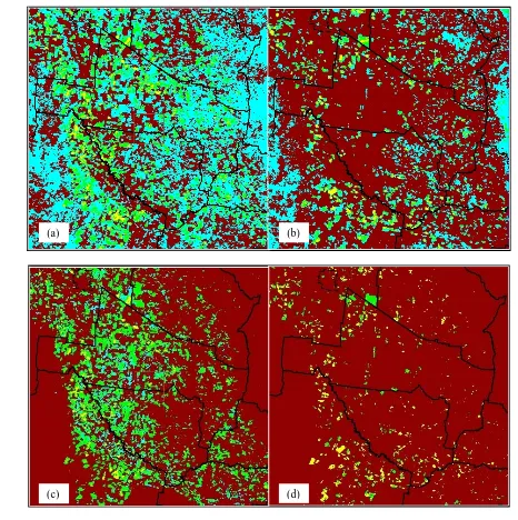
Estimating crop area using seasonal time series of Enhanced Vegetation Index from MODIS satellite imagery
Full text
Figure
Related documents
It might be therefore argued that the gap on the apprenticeship market increased because the German firms are less willing to incur net apprenticeship costs (an indication for
The desired dosage can be set to a constant for the duration of a simulation (5 gallons of dispersant per acre is a typical dosage) or ROC will attempt to achieve the dosage
The Partnership to Strengthen the Executive MBA Program (EMBA) at Alexandria University was initiated to help strengthen this EMBA program and create a mechanism within the Faculty
Minimise waste generation and maximise reuse and recycling Prevent all environment incidents Maximise opportunitites for business and community Minimise carbon
Similarly, CYP450 inducers, such as rifampin, carbamazepine, and phenytoin, may induce the metabolism of oxycodone and, therefore, may cause increased clearance of the drug
CHLB members develop collaborative strategic plans and action plans relevant to the Boards focus of work using community health needs assessment data.. CHLB members
Estimate (21) , obtained from our model, considering only non- Fickian diffusion with memory in time and space, is a typical estimate for wave-type equations and not similar to
We can see in Figure 1 the error measured using E 1 and E 2 metric of the two subsets of pairs computed using dimensionality reduction methods, a random set of pairs and the
