This is a repository copy of
When is a terrace not a terrace? The importance of
understanding landscape evolution in studies of terraced agriculture
.
White Rose Research Online URL for this paper:
http://eprints.whiterose.ac.uk/112206/
Version: Accepted Version
Article:
Ferro Vazquez, Maria De La Cruz, Lang, Carol orcid.org/0000-0002-0437-5585, Kaal,
Joeri et al. (1 more author) (2017) When is a terrace not a terrace? The importance of
understanding landscape evolution in studies of terraced agriculture. Journal of
Environmental Management. pp. 500-513. ISSN 0301-4797
https://doi.org/10.1016/j.jenvman.2017.01.036
eprints@whiterose.ac.uk https://eprints.whiterose.ac.uk/ Reuse
This article is distributed under the terms of the Creative Commons Attribution-NonCommercial-NoDerivs (CC BY-NC-ND) licence. This licence only allows you to download this work and share it with others as long as you credit the authors, but you can’t change the article in any way or use it commercially. More
information and the full terms of the licence here: https://creativecommons.org/licenses/
Takedown
If you consider content in White Rose Research Online to be in breach of UK law, please notify us by
When is a terrace not a terrace? The
importance of understanding landscape
evolution in studies of terraced agriculture
*C. Ferro-Vázquez1; C. Lang1; J. Kaal2, 3 and D. Stump1 *Corresponding author: cruz.ferrovazquez@york.ac.uk
1
Department of Archaeology, University of York. King’s Manor, York, YO1 7EP UK
2
Institute for Heritage Sciences (Incipit), Spanish National Research Council (CSIC), Avenida de Vigo s/n, 15780 Santiago de Compostela, Spain.
3
Departamento de Edafoloxía e Química Agrícola, Fac. Bioloxía, Universidade de Santiago de Compostela, Campus Sur, 15782 Santiago de Compostela, Spain.
http://dx.doi.org/10.1016/j.jenvman.2017.01.036
Abstract
Before the invention of modern, large-scale engineering projects, terrace systems were rarely built in single phases of construction, but instead developed gradually, and could even be said to have evolved. Understanding this process of landscape change is therefore important in order to fully appreciate how terrace systems were built and functioned, and is also pivotal to understanding how the communities that farmed these systems responded to changes; whether these are changes to the landscape brought about by the farming practices themselves, or changes to social, economic or climatic conditions. Combining archaeological stratigraphy, soil micromorphology and geochemistry, this paper presents a case-study from the historic and extensive terraced landscape at Konso, southwest Ethiopia, and demonstrates – in one important river valley at least – that the original topsoil and much of the subsoil was lost prior to the construction of hillside terraces. Moreover, the study shows that alluvial sediment traps that were built adjacent to rivers relied on widespread hillside soil erosion for their construction, and strongly suggests that these irrigated riverside fields were formerly a higher economic priority than the hillside terraces themselves; a possibility that was not recognised by numerous observational studies of farming in this landscape. Research that takes into account how terrace systems change through time can thus provide important details of whether the function of the system has changed, and can help assess how the legacies of former practices impact current or future cultivation.
1
Introduction
In common parlance the term ‘agricultural terrace’ is well understood, and it is well understood too
that terraces can produce a range of benefits including limiting surface water run-off and reveting soils, thereby reducing soil erosion; increasing topsoil depth and water infiltration and retention, thereby increasing yields; improving drainage or redirecting excess water flows, thereby mitigating erosion, conserving water and protecting dry-adapted plants; as well as increasing soil temperatures, thereby promoting seed germinating. However, it should be clear even from this very short summary that no single terrace can perform all of these functions: a terrace could not be designed to both improve water retention and improve drainage, for example. This is not simply a question of engineering semantics (i.e. that the catch-all term ‘agricultural terrace’ encompasses a range of structures that are built in different ways to solve different problems) because a particular type of terrace such as the common cut and fill levelled bench terrace could be managed to perform different functions even within the same hillside: exposed to increased soil temperature in one location, while shaded and irrigated in another. Cost-benefit analyses reporting positive results for the construction of terraces in a given time and location (e.g. Bizoza and De Graaff, 2012; Tesfaye et al., 2016) must therefore be taken in context, and produce conclusions that cannot, of course, be readily transposed to a different time and place.
This point, though in some ways a statement of the obvious, is illustrated in the current paper by reference to archaeological and pedological research at the impressive terraced landscape in Konso, southwest Ethiopia; a landscape that was listed as a UNESCO World Heritage Site in 2011, includes some 40 historic walled towns surrounded by an estimated 200km2 of dry-stone agricultural terracing (Kimura, 2006), and which is thought on the basis of genealogical evidence to have included terracing and perhaps supplementary irrigation approximately 500 years ago (Amborn, 1989). Whether or not this date is a true reflection of when terracing was first employed at Konso has yet to be confirmed archaeologically, but it is clear from early 20th-century accounts (e.g. Harrison, 1901) that the area was extensively terraced at this time, and it is thus reasonable to assume that the practice of building terraces began more than a century earlier. Attempts to date the terraces directly are underway, but regardless of the exact date of inception it would be a mistake to assume that the whole of the 200km2 of terraces were built simultaneously, and mere conjecture to conclude that the function of the terraces has remained constant: terraces constructed to produce high value tradable crops might have later been converted to grow staples for domestic consumption, for example. A long-term perspective can provide these answers (Hayashida, 2005), employing archaeobotanical methods to examine what crops were grown and consumed (the results of which for the current case-study are forthcoming), and employing archaeological stratigraphy combined with studies of soil formation to define the function of particular terraces and the consequences of their construction. This is because archaeological excavation is designed to discern the order in which sediments are deposited and the sequence in
which structures are built, meaning that excavation is able to effectively ‘reverse engineer’ features
such as agricultural terraces. This is important because doing so helps discern which of the priorities listed above a particular terrace was designed to fulfil, and can help assess how effective a particular terrace system was at achieving these.
1954; Straube, 1967), with the agricultural system itself subsequently studied by geographers (Watson, 2009) and by agronomists and others interested in the developmental lessons that might be learnt from studies of so-called ‘indigenous knowledge’ (e.g. Abate, 1992; Beshah, 2003; Demeulenaere, 2002; Förch, 2003; Tadesse, 2010). This offers clear advantages, because the social, cultural and managerial aspects of the operation of the agricultural system that would be hard or impossible to see archaeologically are well understood, at least for the late 20th and early 21st centuries. By examining historic terraces directly it is possible to extend this understanding back into the deeper past, but direct examination of structures and the soils within terraces that continue to be farmed can also be used to test the conclusions drawn by these observational studies. As the results outlined below illustrate, this ability can generate insights that both complement and extend those derived from other research techniques.
Importantly, this ability to examine the function, efficacy, construction sequence and environmental consequences of terrace systems strongly suggests that previous observational studies did not fully appreciate some elements of the Konso landscape by assuming that terraces were designed to conserve the original topsoil from erosion, and by underestimating the value of a particular type of
agricultural ‘terrace’ (more properly described as a sediment trap or check dam) that are mentioned only briefly in previous published accounts (Amborn, 1989, citing Kuls, 1958; and Straube, 1967) or which were described as only existing in the far northwest of the landscape (Beshah, 2003). The argument here, therefore, is that assessments of the efficacy, sustainability or resilience of a system of environmental management are substantially strengthened by an understanding of its history; a point of direct relevance to Konso given that a report by the United Nations Food and Agriculture
Organisation described the terrace system as offering important “lessons from the past” (FAO, 1990), and given that agricultural practices in Konso have been the subject of research by the British-based NGO FARM-Africa (see Hallpike, 2008 citing FARM-Africa 1993a and 1993b) which produced recommendations for large-scale irrigation projects in the area (Camacho, unpublished report), aspects of which were subsequently implemented. The research reported here helps place such interventions in their historical context, and serves to emphasize that there are many reasons why a community might choose to build or abandon agricultural terraces.
2
Study area. Topography and overview of previous
research
The densest concentration of agricultural terracing in the Konso highlands centre on approximately
5°18’30” North / 37°23’30 East, with the entirety of the terraced landscape located within the Konso
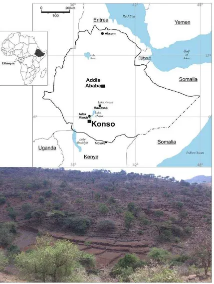
Figure 1. Above: location of Konso in relation to the administrative centre for the region (Hawassa). Below: hillside terraces (background) and yela sediment traps (foreground) in the Sahayto area, located in the northeast of the Konso highlands.
Highlands of this type are highly economically significant in Ethiopia, since nearly half of the
country's total area and approximately 95% of the country’s cultivated land lies above 1500m asl (Krüger et al., 1996). This area is also the most populous, with estimates from the 1990s indicating that nearly 90% of the population lived above 1500m asl (Krüger et al., 1996) while approximately
[image:5.595.76.505.68.638.2]sub-humid agro-ecological zone between 1500 and 2300m asl classified in Ethiopia as Woina Dega (Tadesse, 2010). With temperatures varying from 15 to 33°C these areas are potentially highly productive agriculturally, but are also highly susceptible to soil erosion; a problem considered to be a major threat to agricultural development and food security in highland Ethiopia (ITPS, 2015; Lemenih et al., 2005; Tadesse, 2001). Vertic and argic soils are frequent in stable topographical positions, but the steep topography and the high erodibility of edaphic materials have a major effect on the distribution of fertile soils, with shallow and stoney soils frequently found on hill slopes, thereby creating challenges in maintaining soil fertility.
The construction of terraces is of course a potentially highly effective way of mitigating these risks, and this has prompted - in Ethiopia as elsewhere - an interest in local systems of agricultural terracing that might act as models for erosion mitigation and/or agricultural intensification to maintain soil fertility and achieve higher crop yields (e.g. Bruins et al., 1986; Hogg, 1988; Reij et al., 1996). Given an estimate by the Ethiopian Environmental Protection Authority (EPA) that 80% of the cultivable land in Konso is terraced (EPA, 2004) it is unsurprising that the area has been a focus of interest by
proponents of ‘indigenous’ soil and water conservation (e.g. Adams and Anderson, 1988; FAO, 1990 see also; Grove and Sutton, 1989; Watson, 2009). This having been said, much of the work at Konso
that can broadly be categorized under the heading of ‘indigenous knowledge’ research has explored
aspects of environmental and agricultural management other than terracing, including the maintenance of forests as sacred groves, fire breaks and as retreats during military raids (Demeulenaere, 2002); studies into the use of wild foods, particularly in times of drought (Addis et al.; Guinand and Lemessa, 2001); an examination of the value of the so-called cabbage tree (Moringa stenopetala), the leaves of which form an important part of the local diet (Jahn, 1991); as well as more general studies of the agricultural system as a whole (Forch, 2003); and an interview-based project that aimed to study how Konso farmers perceived both local and introduced soil and water conservation techniques (Beshah, 2003).
Importantly, these more recent works can also be contextualized by reference to earlier studies, including the work of six anthropological expeditions to the area carried out between 1934 and 1974 (e.g. Amborn and Straube, 2009 ; Jensen, 1936; 1960; Nowack, 1954; Straube, 1967), not all of which are published, but photographs, sketches, field notes and various versions of an unpublished Konso manuscript are held by the Frobenius Institute library. From this published and archival data it is clear that terraces have periodically been abandoned during the 20th century, and when compared with later sources provide significant data on how this agricultural system has changed through time. These changes include reductions in the level of stock held in Konso, changes in crops grown, and declines in the length and frequency of fallow periods. However, the records also show apparent continuity, for example repeated references to the best maintained and most intensively cultivated terraces being in the northeast of the Konso highlands, though even here there were evidently periodic short-term depopulations, such as the apparent large reduction of the population of villages by up to 75% in the early to mid-1950s attributed locally to droughts. It is argued here, therefore, that interdisciplinary research that compares historical data with modern observations are better able to assess the operation and future sustainability of terrace systems; a point returned to below.
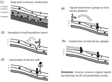
landscape is comprised predominately by bench terraces(e.g. Förch, 2003; WOCAT, 2010); a reasonable conclusion given that some sources describe terrace construction as starting with the
excavation of a ‘foundation trench’ (Beshah, 2003 uses the term "basement") into which the lower courses of a dry-stone wall are inserted, which is then followed by the dragging of soil from upslope to create a broadly level cultivation platform, with subsequent terraces being built progressively up the slope (cf Amborn, 1989; e.g. Beshah, 2003). Although this does indeed broadly describe one method of building a bench terrace (Figure 2), aspects of this account seemed questionable, particularly the function of the wall foundation cut. It is therefore worth attempting to confirm or
refute this characterisation, especially given that Beshah’s informants merely described this process,
[image:7.595.88.457.263.532.2]and noted that although old terraces are still maintained, no members of the community have participated in the building of new terraces.
Figure 2: Schematic representation of the process of hillside terrace construction as described to Beshah (2003). Compare this schematic to that based on excavation, Figure 4.
3
Methods
Prior to excavation, the geology and geomorphology of the catchment were surveyed, with these surveys including examinations of examples of terrace profiles exposed by gullies, as well as sediment trap profiles exposed within the sides of the river bank. These surveys noted land use, vegetation, parent material, erosion features, depth of sediment profile, macromorphological signals of horizonation and polycyclism (i.e. more than one cycle of soil formation within a soil profile) and the possibility of stratigraphic sequencing. From the results of the survey five locations considered representative of the different geomorphological positions and stratigraphic sequences were selected for excavation, with excavation comprising either the cutting back of faces of existing exposures to remove any potentially disturbed or contaminated deposits, or the excavation of trenches close to these exposures to enable the safe examination of undisturbed terrace walls and associated deposits.
The resulting profiles were all at least two meters wide, are referred to here as ‘sections’, and the
deposits within them assigned arbitrary numbers starting at 100 to distinguish these from investigations undertaken by a pilot study in 2010. Details of two of these sections are presented here as the most illustrative and informative, and comprise one examining a terrace in slope positions
(Section 118), located at 5°19’44.3”N/37°27’22”E, and a second investigating a riverside sediment
trap (Section 102) located at 5°19’33.1”N/37°27’24.4”E.
Studies of agricultural fields are generally controlled by comparison to uncultivated contexts. However, no representative non-terraced or uncultivated test plots were available, as in the study area
essentially all land was either currently cultivated or had been in the past. Soils in two ‘sacred forests’
located on hilltops nearby were surveyed as a means to understand uncultivated pedogenesis and stratigraphy. However, these soil sequences are not suitable as control locations for this study, given that their geomorphological positions were not equivalent and they were not within the same catchment of our study area. The environmental conditions and the processes undergone by these soils were therefore probably different, and they are considered inadequate as a background setting. The presence of some relict pedogenetic features of the original dynamics below terraced layers in the surveyed slope soil profiles has nevertheless allowed this shortcoming to be partially addressed. Stratigraphic methodology, soil sampling and laboratory methods are described in detail in the online supplementary material (SM1).
4
Results
4.1
Stratigraphy and soil descriptions
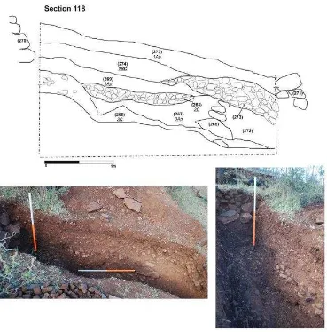
two parts of the same deposit that has been truncated by the excavation of a foundation trench for the construction of wall (266).
Figure 3: Scale drawings and photographs of hillside terrace deposits within Section 118. Photographic scales all 1m.
These observations have two significant ramifications. First, that wall (266) was built directly on to either exposed bedrock or exposed relic saprolite, meaning that the original topsoil and subsoil had been eroded away prior to the construction of this terrace wall. Second, the lack of a subsoil layer between saprolite (265) and the physically overlying terrace soils (267) and (272) demonstrates that these palaeosols have not developed in situ within the terrace, and instead have been deposited. Taken together this suggests at least two broad phases of erosion and deposition took place, with the first phase removing the topsoil and subsoil to expose the saprolite or bedrock, while a subsequent later phase incorporated material into the terrace formed by wall (266).
[image:9.595.80.449.121.495.2]deposition of the layer that also forms the modern topsoil (275) which stratigraphically postdates palaeosol (274) and physically buries stoney layer (273), thereby creating a relatively stone-free cultivation layer. Although on the basis of stratigraphic data the upslope terrace wall (270) could have been built immediately after the deposition of former cultivation layer (269) it is equally possible that this wall sits within a trench cut that post-dates current topsoil (275); an interpretation that would fit with observations from other excavation sections, and which could be regarded as receiving support from the descriptions of terrace construction recorded by Amborn (1989) and Beshah (2003 105).
Section 118 thus shows the construction of three and probably four terraces: first the terrace associated with wall (266), then that represented by stoney layer (268) and the subsequent palaeosol (269), followed by the terrace bounded on its downslope side by riser wall (271), and finally by the construction of wall (270). In terms of pedegenic classification the deposits thus form a 1Ap, 1BC, 2Ap, 2C, 3Ap, 3C, R sequence. This is perhaps clearest if illustrated, and a simplified schematic of this sequence is presented in Figure 4.
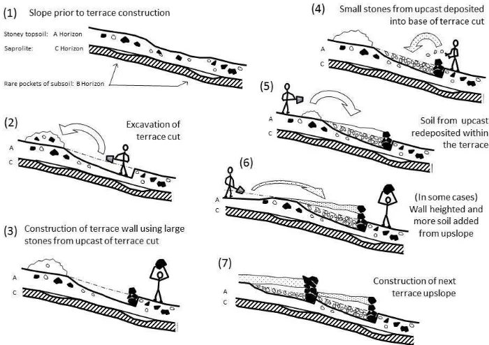
Figure 4. Sequence of hillside terrace construction as revealed by stratigraphy and soil descriptions, demonstrating loss of original topsoil and most subsoil prior to terrace construction, and suggesting that terracing was undertaken partially to reduce the number of stones in the upper rooting zone. Compare this sequence to that described during interviews shown in Figure 2.
[image:10.595.121.471.312.559.2]then subsequently buried by later deposits of fine material, which are themselves contained by inclined walls. The only process that accounts for these observations is if each wall is built incrementally by no more than three courses at a time, since this would seem to be the maximum number of courses that could be supported by the gravels placed behind and beneath the inclined drystone courses; these deposits of gravel typically extending for no more than 60mm behind the wall. Fine sediments entrained within running water are then captured behind the wall, permitting more drystone courses to be added and subsequent alluvial sediments to be captured. Once this manner of sediment accumulation had been identified, questions regarding this construction method were asked of local informants, who noted that this technique was now rarely used but that a field of this type is
known as a ‘yela’.
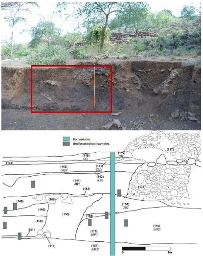
Figure 5: Photograph and scaled drawing of east-facing Section 102. The blue rectangle indicates the position of the soil sampling column, and the grey boxes mark the undisturbed samples collected for micromorphological analyses. Numbers in brackets indicate the depositional events as described in the field. Note that the drawing shows oblique segments of the drystone walls (137), (138) and (117) and the packing deposit behind wall (100)/(117): (153). The drawing does not show true cross-sections of these walls, therefore. The seasonal river at this location flows from north to south. Photographic scale 2m
[image:12.595.91.506.69.592.2]4.2
Soil micromorphology
The basic coarse rock and mineral components identified in the thin sections (mainly basalt, feldspar and calcite) were consistent with the geological survey, macromorphological observations and the pXRF analysis. A summary of the main micromorphological features can be found in the online supplementary material information (SM3). Micromorphological differences within the Section 102 can best be expressed by the differences in the fine material (b-fabric), the presence of charcoal, the coloration and presence of the redoximorphic nodules, and the overall microstructure.
In general terms, Section 102 displayed subangular blocky peds separated by inter-pedal channels with intra-pedal chambers and vughs (SM3). Granular peds identified in several samples are thought to be artefacts of sampling and slide manufacture due to high levels of gravel causing poorly aggregated soils. Modern root material was observed in the upper deposits and identified due to the level of birefringence (Babel, 1975 454). At the bottom of the section (116) there is evidence of increased clay content, with the formation of both subangular and angular blocky peds, the latter
separated by accommodated planes. Deposit (116) also contains unmistakable ‘onion skin’ formations
around small fragments of sub-rounded, highly weathered basalt indicative of in situ weathering. Calcite inclusions (SM4: Figure 1A) were exhibited together with calcite coatings both on and within the degraded basalt (fine clay) of (116), however crystalline calcite coatings and inclusions were only observed in two deposits: (154) the final layer in the same yela field as (116), and in (150), an early deposit in the layer built immediately downstream of the yela containing (116) and (154). This suggests slower evaporation had taken place in deposits (150) and (154) and may relate to differences in temperature, thus effecting evaporation rates (Durand et al., 2010 116).
These were also identified in (154), (150) and (144) where fragmentation had occurred. According to Nettleton and Sleeman (1985) churning processes associated with vertic soils can cause the fragmentation of coatings.
4.3
Soil Geochemistry
The depth variations of the main physico-chemical soil properties and elemental composition recorded from the soil column at Section 102 are depicted in online supplementary materials (SM4: Figure 2). The proportion of gravel (grain size > 2 mm) in the column ranged from 9.3% (SM4: Figure 2A) in the deeper part of the soil - (157) and (116) - to 50.3% at 105 cm, coinciding with the (155) stone and gravel layer above layer (116). High gravel contents are also observed at 35 cm [47.6%, corresponding to deposit (143)] and at the soil surface (48.1%).
The soil within the Section 102 sample column is generally alkaline (SM4: Figure 2B), pHw ranging
from 7.9 at the soil surface to 8.7 at 105-110 cm. Below 110 cm, pHw decreased again to 8.1-8.2,
probably related to higher carbonate contents. The calcium carbonate is probably provided by irrigation water and had precipitated secondarily in the soil, producing Ca enrichments with respect to Sr and Al (Ca/Sr and Ca/Al molar ratios (SM4: Figure 3A and B), at 35-40 and 110-125 cm, were the carbonate content is larger probably as a result of a more prolonged irrigation and/or evapotranspiration. The total C content suggests also a higher abundance of calcium carbonate in this part of the soil. Carbon concentration ranges between 7.0 and 23.5 g kg-1 being the bottom part of the soil [110-200 cm, corresponding with (116) and (157)] deposition events as seen in SM4: Figure 2C) more C rich (19.7±3.4 g kg-1) than the upper soil layers (9.0±1.9 g kg-1). Total N is generally low, decreasing with depth from topsoil (1.0-1.3 g kg-1 in the upper 20 cm) to 70 cm (where the N contents are below the detection limit) and then progressively increases with depth (SM4: Figure 2D). The C and N content are correlated (r2=0.70) in samples from topsoil to 105 cm depth [(155) deposit], but not in the bottom part (110-200 cm), where C is proportionally higher. Despite this evident CaCO3
accumulation, crusts were not observed in the Section 102 soil. This could be due to the elimination of incipient carbonate crusts by cultivation or because of upward movement of the rooting depth as a consequence of deliberate annual sediment inputs. Other yela soils surveyed in this area, however, displayed cemented carbonate crusts, their formation perhaps suggesting abandonment periods, as discussed below.
The depth variation in the Ti/Zr ratio (SM4: Figure 3E) reflects that the parent material source(s) has changed through time, from a highly uniform composition within the deeper soil layers [(116) and (157)], to a more variable curve from 105 cm towards soil surface. This is in agreement with the changes in gravel content in the soil, and therefore probably reflects a higher proportion of basaltic unweathered materials in these upper soil layers. The K/Rb molar ratios (SM4: Figure 3F) depict a similar depth variation curve (r2=0.67).
conditions are re-established, Mn would precipitate as Mn oxides within the soil, because the drainage conditions are unfavourable to leaching. In agreement with this, the Fe content is strongly correlated (r2=0.84) to Mn concentrations in the upper part of the soil (0-110 cm) while not in the bottom part, indicating that Fe and Mn post-depositional dynamics are decoupled in (116) and (157) layers, likely as a result of different hydrological conditions.
4.4
Composition of the soil organic matter
The sum of the products that are most likely derived from pyrogenic organic matter (such as charcoal) in the Section 102 soil column; i.e. benzene, benzonitriles and naphthalenes (Kaal et al., 2009) show a marked increase around 110 cm depth, from 18.2 ± 7.0 % to 38.7 ± 7.5 % (SM4: Figure 4A). This coincides with a major decline in the relative proportions of products of degraded OM and OM of microbial origin (furaldehyde, phenols and N-containing products excluding benzonitriles; (furaldehyde, phenols and N-containing products excluding benzonitriles, as indicated by Buurman et al., 2007) from 26.2 ± 3.2 % to 16.7 ± 2.2 % (SM4: Figure 4B). Hence, the pyrolysis fingerprint allows identification of two different sections within the soil profile: a bottom layer where pyrogenic OM is relatively abundant and a top layer where OM composition is mostly controlled by microbial reworking. This boundary coincides more or less with the increase in C content at 110 cm depth, suggesting that the relatively high C content recorded in the (116) and (157) depositional events of Section 102 is related to the relatively recalcitrant nature of pyrogenic OM, or Black C (Goldberg, 1985; Schmidt and Noack, 2000). Indeed, the amount of pyrogenic OM is correlated to the C content (r2=0.71) in the samples below 110 cm. Furthermore, pyrogenic OM is known to be a very strong
black pigment in comparison with other forms of soil OM, which is consistent with the Munsell colour data. Products of relatively intact plant-derived OM such as the guaiacols from lignin, indole from vegetable proteins or pyrans and anhydrosugars from polysaccharides (Abelenda-Suárez et al., 2011; Buurman et al., 2007) were scarce or absent, and concentrated in the top 40 cm of the profile (1.0 ± 0.2 % compared to 0.4 ± 0.3 % below that depth) which is indicative of a strong impact of OM degradation (SM4: Figure 4C).
5
Origin and evolution of the system: from valleys to
slopes
of artificial offtakes (dotatta) and channels (kaba) ensured that flow rates leading to yelas were kept low, and produced an efficient granulometric selection, allowing for sedimentation of only fine materials as identified by grain size analysis. The sedimentary material recorded in the earliest yela layers was thus composed mostly of clay and pyrogenic OM, lacking coarse fragments of transported geological materials.
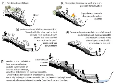
As a result of extensive and/or repeated fires within the catchment it seems that the former vegetation was comprehensively removed, perhaps being today exemplified by the small areas of ‘sacred forest’ that still exist on hilltops. Removal of vegetation would have brought increased erosion and its associated risks (Figure 6), exacerbated by the lithology of the soils parent materials: weathering of basalts under fluctuating hydrological regimes and relatively warm temperatures producing high amounts of smectitic clay (Eggleton et al., 1987; Nyssen et al., 2000; Vingiani et al., 2004) which may provoke swelling and shrinking pressures and make slopes unstable. This would have contributed to destabilization of the slopes, increasing gully erosion and the risk of landslides (Frankl et al., 2012; Heshmati et al., 2013; Kerr, 1972). The (155) stone and gravel layer at 105 cm depth in Section 102 evidences a higher energy erosive event that contributed coarse material to the surface of the yela, in a process consistent with the dynamics of a deforested landscape, and likely would have caused damage to fields and crops (Figure 6). Other studies in East Africa have stressed the widespread incidence of land degradation processes due to human activities, particularly deforestation. These comprised soil erosion (Billi and Dramis, 2003), chemical soil degradation (FAO and ITPS, 2015; Lemenih et al., 2005) and the destabilization of the water budget (Legesse et al., 2003). In the north western Ethiopian highlands Zeleke and Hurni (2001) reported a serious trend of land degradation resulting from the expansion of cultivation on steep slopes at the expense of natural forests, and Bewket and Stroosnijder (2003) noted the problem of downstream sedimentation caused by upstream degradation resulting from land use/cover changes, that could create extensive flooding and damage on important agricultural lands when not properly managed.
It should be stressed that the existence of yelas is acknowledged in the existing literature, but it is noteworthy that they are devoted very little attention in the published accounts. Amborn (1989), for
example, mentions fields in Konso “consisting of thick alluvium which is highly valued”, and cites
Kuls (1958) and Straube (1967) to conclude that “the alluvial deposition of minerals has a manuring
effect”; an idea not specifically tested for in the geochemistry reported here, but one worthy of
consideration in future studies examining the productivity and sustainability of the yela fields in particular, and of the Konso agronomy as a whole. Moreover, it seems clear that previous work did not consider how these yela fields came to exist, with Amborn (1989) noting that in these irrigable
riverside plots the “ground is carefully levelled”; a statement that is both accurate but susceptible to
[image:17.595.76.477.295.591.2]misinterpretation: the fields are not laboriously levelled after the alluvium has been deposited, but are level as a consequence of the careful control of water and the sediments entrained within it. Beshah (2003), in contrast, does mention “flood harvesting” and note that alluvium is deliberately captured in some fields, but the existence of these sediment traps is only noted in the far northwest of the Konso landscape.
Figure 6: Schematic representation of the landscape development sequence in the Sahayto area, northeast Konso.
strategies can be found in other East African systems (see, e.g. Bruins et al., 1986; Reij et al., 1996; and Stump, 2006), and in archaeological and currently farmed sites worldwide, as shown e.g. in Ashkenazi et al. (2012) et al. for the Negev Desert; and Norton et al. (1998) and Sandor et al. (2007) for North American arid zones. An extensive review can be found in Barrow (2014).
In the upper part of the Section 102 yela sequence, above the stoney layer (155), the geochemical and micromorphological signal is quite different: pyrogenic OM is scarcer, and the amount of gravel increases progressively towards the soil surface. There is also evidence of a change in the sedimentary parent material, with a higher proportion of fresh basalt fragments. It seems that the hydrological regime of the yela had changed, displaying a Fe-oxides red coloration compared to the black coloration below, and exhibiting a decrease in C and Mn oxides. The increased amount, larger size and angular shape of the gravel in this part of the soil would indicate that the material would not solely have derived from the river, since the irrigation method prevents the transport of coarse rock fragments from the river into the yela, as commented above. Rather, by this period the yelas were also receiving material from the slopes due to runoff. Nonetheless, the lack of rock fragments bigger than 2-3 cm would point to an already controlled water runoff flow: the capture of predominately fine material in the yela indicates that the risk of direct inputs from the adjacent hillsides had been mitigated by this time, i.e. after the period in which hillside terraces were being constructed.
At 35 cm depth in Section 102 - depositional event (143) - a new stone layer indicates a further high energy erosive process, perhaps related to a deterioration of the terraces upslope, and could suggest a temporary abandonment of this agricultural land. This is in agreement with the polycyclic soil sequence of Section 118, in which clear morphological and stratigraphic evidence for the continued construction of new terraces above earlier examples were observed. In addition, the depth variation of the Ca content respecting to Sr and Al (Ca/Sr and Ca/Al molar ratios) in the Section 102 column sample showed higher values at 35-40 cm and 105-130 cm depth, coinciding with both stone layers and immediately underneath them, suggesting more prolonged or intense evapotranspiration periods. This might be in agreement with the conditions prompted by a temporary abandonment. However, if this abandonment did occur it cannot have spanned a prolonged period, as otherwise the absence of tilling and the concomitant slow recovery of vegetation would have led to the formation of cemented carbonate crusts (García-Ruiz and Lana-Renault, 2011; Lasanta et al., 2000) that are absent in the Section 102 soil. Hardened carbonate crusts were observed in other abandoned yelas during the visual survey and these were also identified in subsurface positions in currently farmed yelas.
6
Implications for land management
has constituted an agronomic resource, the system having initially relied on soil erosion to be productive, and the community having apparently only begun the process of protecting the hillsides in order to protect the productive alluvial fields that were the legacy of that first phase of erosion.
It is thus noteworthy that modern studies and assessments have up to now focussed solely on the hillside terraces, which were assumed to be the key agronomic resource of the system, while yela fields, which have been demonstrated in this work to have been an essential resource in the past, have been mostly overlooked. That is because previous studies did not always recognise that the ‘terraces’ next to rivers and adjacent to streams in hillside valleys were distinct from the hillside terraces that surround them. It is stressed here, however, that this oversight is understandable, and indeed the only reason that the current project recognised the former – and possibly current – importance of the yelas was because it had the stated aim of understanding how the terrace system was originally designed to function, and because to do this it sought to understand how the system changed through time.
Future research into the productively and sustainability of the Konso system should thus certainly approach the yelas as a distinct field type and help design future management plans accordingly. It is conceivable, for example, that it may actually be beneficial to tolerate a certain amount of hillside soil loss in order to maximise their productivity; a position that would stand in marked contrast to projects designed to limit soil erosion through reforestation (e.g. Bishaw, 2001; Jagger and Pender, 2000; see also EPA, 2012; Watson, 2009; Yiman, 2011) or via the construction or maintenance of terracing or bunds (e.g. Liniger et al., 2011;WOCAT, 2010).
Fundamentally, this in essence also means recognizing that no one type of terracing is suited to all landscapes, and that all resource use strategies – including terrace systems - change through time. There are many ways that this could be illustrated through reference to the data presented here, but one way of doing so would be to note the apparent evidence of periodic abandonments – perhaps perceived locally as no more than extended fallows – within the sedimentary record of the investigated yelas. At present it is far too early to regard these as evidence of a failure to adequately maintain terraces, and although previous studies have regarded the level of terrace maintenance at Konso as a proxy for the health and sustainability of the system (Jones, 2009), it is equally possible that periodically prioritizing other areas of the landscape was – and perhaps remains – an informed decision by local farmers.
To return to the thus far rhetorical question that heads this paper: when is a terrace not a terrace? We can now respond with the answer: when it is a sediment trap. But we can also reformulate this question to one that is more relevant to the estimated 200 km2 of hillside terraces: when is an erosion prevention terrace not simply an erosion prevention terrace? When it is not designed to prevent the
loss of the original topsoil, but is instead designed to ‘manufacture’ new soils, in this case by
capturing eroding colluvium, and by removing the frequent stones within this material to produce a relatively stone-free and more easily tilled terrace soil. To have done this over such an extensive area over an as yet unknown period is undoubtedly a remarkable achievement, but this is not the same as saying that the Konso landscape is self-evidently a paradigm of ‘indigenous’ soil and water conservation. More importantly, it is not in itself evidence that the system will continue to be highly productive or highly sustainable in the future.
This and other aspects of Konso history have still to be studied, and includes research that must be led by experts in modern agronomy and environmental management. Nonetheless, the evidence presented here has demonstrated that knowledge of past processes is important in understanding the mechanisms
7
Acknowledgements
We are grateful to the farmers who allowed us to work in their land. Thanks are also due to the Ethiopian Authority for Research and Conservation of the Cultural Heritage (ARCCH), which awarded the research permits to undertake the field research (Archaeological Research Permit, Ref. No. D8/R-4-1/001), with particular thanks to the ARCCH representatives: Degsew Zerihun, Gesimo Gesese and Muluneh Tefera for their invaluable contribution to the fieldwork.
The work reported upon here was funded by two European Union research grants: the ‘Archaeology
of Agricultural Resilience in Eastern Africa’ project (AAREA) funded by the European Research
Council under the European Union’s Framework Seventh Framework Programme
(FP/200702013/ERC Grant Agreement No. ERC-StG-2012-337128-AAREA) Starter Grant Scheme awarded to Stump; and the ‘Resistance and Resilience of Ancient Agricultural Soils’ project (tRRACES) funded by the People Programme (Marie Curie Actions) of the European Union's Horizon 2020 Programme (tRRACES-H2020-MSCA-IF-2014-657355) awarded to Ferro-Vázquez (Fellow) and Stump (PI). Archival research at the Frobenius Institute, Frankfurt was funded by the Wenner-Gren Foundation (Grant number 8281). Geochemical analytical work has been partially funded by the Grupos de Potencial de Crecimiento program of the Xunta de Galicia (Grant number GPC2014-009).
8
References
Abate, T., 1992. Resource Use in Konso. Sociology Ethnology Bulletin 1, 22-25.
Abelenda-Suárez, M., Buurman, P., Camps Arbestain, M., Kaal, J., Martinez Cortizas, A., Gartzia Bengoetxea, N., Macías, F., 2011. Comparing NaOH extractable organic matter of acid forest soils that differ in their pedogenic trends: a pyrolysis GC/MS study. Eur. J. SoilSci. 62, 834-848.
Adams, W.M., Anderson, D.M., 1988. Irrigation before development: indigenous and induced change in agricultural water management in East Africa. African Affairs 87, 519-535.
Addis, G., Asfaw, Z., Woldu, Z., 2013. The role of wild and semi-wild edible plants to household food sovereignty in Hamar and Konso communities, South Ethiopia. Ethnobotany Research and Applications 11, 251-271.
Amborn, H., 1989. Agricultural intensification in the Burji-Konso cluster of south-western Ethiopia. Azania: Archaeological Research in Africa 24, 71-83.
Amborn, H., Straube, H., 2009.Flexibel aus tradition Burji in Äthiopien und Kenia: unter Verwendung der Aufzeichnungen von Helmut Straube(with explanation of some cultural items in English). Otto Harrassowitz Verlag.
Ashkenazi, E., Avni, Y., Avni, G., 2012. A comprehensive characterization of ancient desert agricultural systems in the Negev Highlands of Israel. J. Arid. Environ. 86, 55-64.
Babel, U., 1975. Micromorphology of soil organic matter. In: Gieseking, J.M. (Ed.), Soil Components: organic components. Springer-Verlag.
Barrow, C.J., 2014. Alternative irrigation: the promise of runoff agriculture. Routledge.
Beshah, T., 2003. Understanding farmers: Explaining soil water conservation in Knoso, Wolaita and Wollo, Ethiopia. Wageningen University and Research Center.
Billi, P., Dramis, F., 2003. Geomorphological investigation on gully erosion in the Rift Valley and the northern highlands of Ethiopia. Catena 50, 353-368.
Bishaw, B. 2001. Deforestation and Land Degradation on the Ethiopian Highlands: A Strategy for Physical Recovery.
Bizoza, A., De Graaff, J., 2012. Financial cost–benefit analysis of bench terraces in Rwanda. Land. Degrad. Dev. 23, 103-115.
Bruins, H.J., Evenari, M., Nessler, U., 1986. Rainwater-harvesting agriculture for food production in arid zones: the challenge of the African famine. Appl. Geogr. 6, 13-32.
Buurman, P., Peterse, F., Almendros Martin, G., 2007. Soil organic matter chemistry in allophanic soils: A pyrolysis GC/MS study of a Costa Rican andosol catena. Eur. J. Soil Sci.58, 1330-1347.
Camacho, R.F., 2000, unpublished report. Spate Irrigation in Konso: Review of methods for improvement of spate irrigation. FARM - Africa.
Dalrymple, J.B., Jim, C.Y., 1984. Experimental study of soil microfabrics induced by isotropic stresses of wetting and drying. Geoderma 34, 43-68.
Demeulenaere, E., 2002. Woods, social organisation in Konso. J. Eur. Stud. 35, 81-111.
Durand, N., Monger, C.H., Canti, M.G., 2010. Calcium carbonate features. In: Stoops, G., Marcelino, V., Mees, F. (Eds.), Interpretation of Micromprhological Features of Soils and Regoliths. Elsevier.
Eggleton, R.A., Foudoulis, C., Varkevisser, D., 1987. Weathering of basalt: changes in rock chemistry and mineralogy. Clay Clay Miner. 35, 161-169.
EPA, 2004. Environmental Protection Authority. The 3rd national report on the implementation of the UNCCD/NAP in Ethiopia, Addis Ababa, pp. 25–30.
EPA, 2012. National Report of Ethiopia, the United Nations Conference on Sustainable Development (Rio+20), Federal Democratic Republic of Ethiopia.
FAO and ITPS, 2015. Global status, processes and trends in soil erosion, Status of the World’s Soil Resources
(SWSR) - Main Report. Food and Agriculture Organization of the United Nations and Intergovernmental Technical Panel on Soils. Rome.
FAO, 1990. The conservation and rehabilitation of African lands: an international scheme. ARC/90/4, Food and Agriculture Organization of the United Nations, Rome.
FARM-Africa 1993a. Report of diagnostic survey of Gersale village in Duraite peasants association in Konso Wereda. Simon Adebo. Addis Ababa.
FARM-Africa 1993b. Report of diagnostic survey of Gaho peasants association in Konso Wereda. Simon Adebo. Addis Ababa.
Förch, W., 2003. Case Study: the agricultural system of the Konso in south-western Ethiopia. https://www.uni-siegen.de/zew/publikationen/volume0103/1-wiebke-konso-pubs.pdf (accessed 03/06/2016).
Frankl, A., Poesen, J., Deckers, J., Haile, M., Nyssen, J., 2012. Gully head retreat rates in the semi-arid highlands of Northern Ethiopia. Geomorphology 173, 185-195.
García-Ruiz, J.M., Lana-Renault, N., 2011. Hydrological and erosive consequences of farmland abandonment in Europe, with special reference to the Mediterranean region–a review. Agr. Ecosyst. Environ. 140, 317-338. Goldberg, E., 1985. Black carbon in the environment. John Wiley and Sons.
Grove, A., Sutton, J., 1989. Agricultural terracing south of the Sahara. Azania: Archaeological Research in Africa 24, 113-122.
Hallpike, C.R., 2008. The Konso of Ethiopia: a study of the values of an east cushitic people,rev. ed. AuthorHouse, Central Milton Keynes.
Harrison, L., 1901. A journey from Zeila to Lake Rudolf. Geogr. J.18, 258-275.
Hayashida, F.M., 2005. Archaeology, ecological history, and conservation. Annu. Rev. Anthropol. 34, 43-65. Heshmati, M., Majid, N.M., Jusop, S., Gheitury, M., Abdu, A., 2013. Effects of soil and rock mineralogy on soil erosion features in the Merek watershed, Iran.Journal of Geographic Information System 5, 248-257.
Hogg, R., 1988. Water harvesting and agricultural production in semi arid Kenya. Dev. Change 19, 69-87. Hylander, L.D., Meili, M., Oliveira, L.J., e Silva, E.D.C., Guimarães, J.R., Araujo, D.M., Neves, R.P., Stachiw, R., Barros, A.J., Silva, G.D., 2000. Relationship of mercury with aluminum, iron and manganese oxy-hydroxides in sediments from the Alto Pantanal, Brazil. Sci. Total Environ. 260, 97-107.
Jagger, P., Pender, J. 2000. The role of trees for sustainable management of less-favored lands: the case of eucalyptus in Ethiopia. In: DIVISION., E. A. P. T. (ed.). International Food Policy Research Institute.
Jahn, S.A.A. (1991). The traditional domestication of a multipurpose tree Moringa stenopetala (Bak. f.) Cuf. in the Ethiopian Rift Valley. Ambio, 244-247.
Jensen, A.E., 1936. Im lande des Gada:Wanderungen zwischen Volkstriimmern Siidabessiniens. Strecker und Schröder.
Jensen, A.E., 1960. Feld-Terrassen und megalithen.Paideuma 7,258-273.
Jones, S., 2009. Analysing and mapping the condition of terrace slopes in Konso based on LIDAR-derived DEMs and aerial photography. Trinity Hall, University of Cambridge.
Kaal, J., Cortizas, A.M., Nierop, K.G., 2009. Characterisation of aged charcoal using a coil probe pyrolysis-GC/MS method optimised for black carbon. J. Anal. Appl. Pyrol. 85, 408-416.
Kabata-Pendias, A., 2010. Trace elements in soils and plants. 4th Edition. CRC press.
Kerr, P.F., 1972. The influence of clay minerals on surficial earth movements. DTIC Document.Columbia Univ. New York Dept.of Geology.
Kimura, B., 2006. Spatial distribution of historical Konso settlements, Proceedings of the XVth International Conference of Ethiopian Studies, Hamburg, July 20-25, 2003. Otto Harrassowitz Verlag.
Kovda, I., Mermut, A.R., 2010. Vertic features. In: Stoops, G., Marcelino, V., Mees, F. (Eds.), Interpretation of micromorphological features of soils and regoliths. Elsevier.
Krüger, H., Fantaw, B., Michael, Y., Kajela, K., Riej, C., Scoones, I., Toulmin, C., 1996. Creating an inventory of indigenous soil and water conservation measures in Ethiopia. In: Reij, C., Scoones, I., Toulmin, C. (Eds.),Sustaining the soil: indigenous soil and water conservation in Africa.Routledge. 170-180.
Kuls, W., 1958. Beiträge zur culturgeographie der südäthiopischen Seenregion. W. Kramer.
Lasanta, T., Garcıa-Ruiz, J., Pérez-Rontomé, C., Sancho-Marcén, C., 2000. Runoff and sediment yield in a semi-arid environment: the effect of land management after farmland abandonment. Catena 38, 265-278. Lee, H., French, C., Macphail, R., 2014. Microscopic examination of ancient and modern irrigated paddy soils in South Korea, with special reference to the formation of silty clay concentration features. Geoarchaeology 29, 326-348.
Legesse, D., Vallet-Coulomb, C., Gasse, F., 2003. Hydrological response of a catchment to climate and land use changes in Tropical Africa: case study South Central Ethiopia. J. Hydrol. 275, 67-85.
Lindbo, D.L., Stolts, M.H., Vepraskas, M.L., 2010. Redoximorphic features. In: Stoops, G., Marcelino, V., Mees, F. (Eds.), Interpretation of micromorphological features of soils and regoliths. Elsevier.
Liniger, H.P., Mekdaschi Studer, R., Hauert, C., Gurtner,M. 2011. Sustainable Land Management in Practice – Guidelines and Best Practices for Sub-Saharan Africa. TerrAfrica, World Overview of Conservation Approaches and Technologies (WOCAT) and Food and Agriculture Organization of the United Nations (FAO). Macphail, R.I., Goldberg, P., 2010. Archeological material. In: Stoops, G., Marcelino, V., Mees, F. (Eds.),Interpretation of micromorphological features of soils and regoliths. Elsevier.
Messeret, L., 1990. A study of the technological, social, socio-economic and environmental constraints affecting the performance of Ethiopian agriculture: with special reference to drought anf famine crises in Konso, Gesellschaft fur Wirtschafts- und Regionalsoziologie e.V. Justus-Liebig University.
Minker, G., 1986. Burji-Konso-Gidole-Dullay. Materialien zur demographie, landwirtschaft und siedlungsstruktur eines suedaethiopischen kulturareals.
Nettleton, W., Sleeman, J., 1985. Micromorphology of vertisols. In: Douglas,L.A., and Thompson, M.L., eds., Soil Micromorphology and Soil Classification. SoilScience Society of America, Special Publication 15, 165– 196.
Norton, J.B., Pawluk, R.R., Sandor, J.A., 1998. Observation and experience linking science and indigenous knowledge at Zuni, New Mexico. J. Arid. Environ. 39, 331-340.
Nowack, E., 1954. Land und volk der Konso. Bonner Geographischer Abhandlingen Heft 14, Bonn.
Nyssen, J., Poesen, J., Haile, M., Moeyersons, J., Deckers, J., 2000. Tillage erosion on slopes with soil conservation structures in the Ethiopian highlands. Soil Till.Res.57, 115-127.
Reij, C., Scoones, I., Toulmin, C., 1996. Sustaining the soil: indigenous soil and water conservation in Africa. Routledge.
Sandor, J.A., Norton, J.B., Homburg, J.A., Muenchrath, D.A., White, C.S., Williams, S.E., Havener, C.I., Stahl, P.D., 2007. Biogeochemical studies of a Native American runoff agroecosystem. Geoarchaeology 22, 359-386. Schmidt, M.W., Noack, A.G., 2000. Black carbon in soils and sediments: analysis, distribution, implications, and current challenges. Global Biogeochem. Cy. 14, 777-793.
Soper, R., 1996. The Nyanga terrace complex of eastern Zimbabwe: new investigations. Azania: Archaeological Research in Africa 31, 1-35.
Soper, R., 2002. Nyanga: Ancient fields, settlements and agricultural history in Zimbabwe. BIEA Memoir Series, 16. British Institute in Eastern Africa.
Stoops, G., Eswaran, H., 1985. Morphological characteristics of wet soils.In: Wetland soils: characterization, classification, and utilization: proceedings of a workshop held 26 March to 5 April 1984, Manila. International Rice Research Institute.
Straube, H., 1967. Der agrarische intensivierungskomplex in Nordost-Afrika. Paideuma 198-222..
Stump, D., 2006. The development and expansion of the field and irrigation systems at Engaruka, Tanzania. Azania: Archaeological Research in Africa 41, 69-94.
Tadesse, G., 2001. Land degradation: A challenge to Ethiopia. Environ. Manage. 27, 815-824.
Tadesse, M., 2010. Living with adversity and vulnerability. Ph.D. Thesis, University of Agricultural Science, Sweden.
Tesfaye, A., Brouwer, R., van der Zaag, P., Negatu, W., 2016. Assessing the costs and benefits of improved land management practices in three watershed areas in Ethiopia. International Soil and Water Conservation Research 4, 20-29.
Watson, E.E., 2009. Living terraces in Ethiopia: Konso landscape, culture and development. James Currey. Widgren, M., Maggs, T., Plikk, A., Risberg, J., Schoeman, M.H., Westerberg, L.-O., 2016. Precolonial agricultural terracing in Bokoni, South Africa: Typology and an exploratory excavation. Journal of African Archaeology 14, 33-53
WOCAT, 2010. WOCAT database on SLM (sustainable land management) technologies and SLM approaches.https://www.wocat.net/en/knowledge-base/slm-approaches/database.html(accessed on 06/06/2016) Yiman, A., 2011. A History of Konso Woreda from 1941-1991. University of Addis Ababa.