International Journal of Innovative Technology and Exploring Engineering (IJITEE) ISSN: 2278-3075, Volume-9 Issue-2, December 2019
Abstract: Crop identification (CI) utilizing hyperspectral pictures/images (HSI) collected from satellite is one of the effective research area considering various agriculture related applications. Wide range of research activity is carried out and modelled in the area of crop recognition (CR) for building efficient model. Correlation filter (CF) is considered to be one of an effective method and are been applied by existing methodologies for identifying similar signal features. Nonetheless, very limited is work is carried out using CF for crop classification using hyperspectral data. Further, effective method is required that bring good tradeoffs between memory and computational overhead. The crop classification model can be improved by combining machine learning (ML) technique with CF. HSI is composed of hundreds of channels with large data dimension that gives entire information of imaging. Thus, using classification model is very useful for real-time application uses. However, the accuracy of classification task is affected as HSI is composed of high number of redundant and correlated feature sets. Along with, induce computational overhead with less benefits using redundant features. Thus, effective band selection, texture analysis, and classification method is required for accurately classifying multiple crops. This paper analyses various existing techniques for identification and classification of crops using satellite imagery detection method. Then, identify the research issues, challenges, and problems of existing model for building efficient techniques for identification and classification of crops using satellite image. Experiment are conducted on standard hyperspectral data. The result attained shows proposed model attain superior classification accuracy when compared with existing hyperspectral image classification model.
Keywords: Artificial intelligence, compressive sensing, classification, hyperspectral image, object detection.
I. INTRODUCTION
A
griculture responds delicately with respect with global environmental condition change [1]. This is because by year 2050 the population is expected to touch 9.6 billion [2]. Along with, the worldwide food demand is expanding, and in this way, the accessibility of exact, convenient, and timely data about agricultural on a neighborhood and also on worldwide [3], is fundamental [4] for guaranteeing that a increasing population can be served. So as to address the issues of unpredictability of the food market or meeting country food security, Hyperspectral imaging technique give a wide scope of prospects to measure these difficulties [3],Revised Manuscript Received on December 05, 2019. * Correspondence Author
M.C. Girish Babu*, Department of computer Science & Engineering, Mandya and affiliated to Visvesvaraya Technological University, Belagavi, Karnataka, India. Email: [email protected].
Dr. M.C. Padma. Department of computer Science & Engineering,
Mandya and affiliated to Visvesvaraya Technological University, Belagavi, Karnataka, India. Email: [email protected]
[5]. Remote sensing refers to an art and science of gathering useful information about earth’s surface from a distance [1]. Remote sensing (RS) application play an important part for mapping land usage and land cover feature sets classification that principally incorporates agricultural crops, agricultural yields, and waterbodies etc. [2].
Various viewpoints and problems in farming and agriculture related economy are being addressed utilizing RS. The RS has been applied for agricultural related activities such as for biomass, yield forecasting, crop monitoring, seasonal crop growth development, etc. Exact land spread evaluations structure the reason for such examinations in farming sectors [7], and are predominantly significant for managing water resource [8]. Further, it is also very useful in identifying sustainable land usage management, monitoring shot-term yield forecasting, identifying right type of crop before the season ends, and identifying land for yieldable location for certain type of crops [13]. Along with, present conditions and degree of land spread are required as a reason for environmental change forecasting. In general, the data about agricultural suitable land spread is just accessible only at the higher level (i.e., at administrator levels), while complete data on spatial dissemination is missing or not open to the overall agrarian population for reasons of information privacy/protection guidelines.
The growth of cloud technology has led to growth of increasing collection of hyperspectral BigData. However, these hyperspectral data are not made public. Nonetheless, in recent year’s huge amount of HS data was made public. In the period of 2013–2016, a few synthetic aperture radar (SAR) satellites are being launched. These satellite has a very good spatial resolution of 10 − 30 𝑚. In specific, Landsat-8 was launched by National Aeronautics and Space Administration and Unite Sates Geological Survey, 𝑆𝑒𝑛𝑡𝑖𝑛𝑒𝑙 − 1𝐴/𝐵 and
𝑆𝑒𝑛𝑡𝑖𝑛𝑒𝑙 − 2𝐴 by the European Copernicus (EC) program.
These datasets are openly accessible on operational premise. This opens phenomenal open doors for a wide scope of research activity and service deployment in the agriculture and environment areas exploiting high spatial and temporal datasets and advances in the multi-sources information fusion methodologies. Crop feature set mapping and land usage mapping is on of very essential data sources when managing ecological and agricultural related task monitoring. Multi temporal multisource HSI is generally needed so as to catch explicit yield development stages and in this way aid in distinguishing diverse crop types. For instance, using multispectral (MS) optical image just probably won't be sufficient to distinguish summer crops in an intricate, dynamic and heterogeneous
condition.
A Efficient Solution for Classification of Crops
using Hyper Spectral Satellite Images
For this, SAR-determined data includes an additional information that permits separation of specific harvest types. However, these images are corrupted by a strong noise and this noise degrades the overall quality of the image. Analysis of backscattering microwave image is very complicated in SAR. The essential benefit of using HSI is that it consist of complete spectrum collected at each point, the administrator prerequisites no prior information on the feature and post processing permits all accessible data from the dataset to be analyzed.
Accuracy and credibility of crop monitoring systems, which are developed using classical image processing is challenged by illumination changes, occlusions, geometrical transformations, special resolution and camouflaging. However, the problem of crop identification, tracking, and monitoring of crops through challenging conditions can be addressed efficiently by hyperspectral imaging technologies with higher accuracy. Hyperspectral imaging has a capability for enhancing and revolutionize the techniques used for addressing diverse signal processing (SP) tasks by utilizing high resolution (HR) spectral bands (SB). For assuring better precision of classification performance, compressive sensing (CS), dimensionality reduction (DR), and machine learning technique is attractive and useful. Further, it aid in reducing computational and storage overhead. This work conduct extensive analysis of various existing method of satellite image classification technique and identify the research problem for building efficient techniques for identification and classification of crops using satellite imagery detection method.
In summary, we make the following main research contributions in this paper: This work conduct deep rooted analysis of various satellite image classification method using feature reduction, compressive sensing, machine learning and deep learning based method. Further,
presented a possible research future direction and methodology for building crop detection, identification, and classification approach using satellite image.
This paper represents about different types of technique of identification and classification of crop using satellite imagery, state-of-the-art methodologies for identification and classification of crop using satellite imagery and its challenges. The rest of the paper is structured as follows: In section II, carried extensive analysis of various state-of-art identification and classification of crop using satellite imagery. In section III, the research open issues, challenges, and problems is discussed. In section IV, the proposed methodology for overcoming research challenges and problem in identification and classification of crop using satellite imagery is presented. The result and discussion is described in section V. The conclusion and future work is described in last section.
II. LITERATURESURVEY
This section presents the analysis of various technique for identification and classification of crop using satellite imagery method [26], [27].
A. Crop identification and classification
In [24], the author shows that it is mandatory for the autonomous robotics in the agro-department to give the real
time feedback, however due to diversity of the array objects and missing landscape uniformity, the given objective looks complex. Moreover the recent study has shown that the two implementations of the given MEC(Multiple Expert Color) feature-ELM (Extreme Learning Machine) also known as MEC-ELM, it is a cascading methodology which is implemented along with the SAT(Summed Area Table) for the rapid FE(Feature Extraction) as well as classification of the object. MEC-ELM is said to be the color ELM along with the partial connected hidden layer and this is achieved through taking the three distinctive color band as the input. Moreover the color implementation have used along with the SAT which enables the MEC-ELM to identify and rapidly classify the objects with the fair value of precision and recall in weed detection.
In [25] a methodologies were proposed for efficient croplands mapping as it is said to be the important condition in case of sustainable agriculture and for periodically monitoring corps. Increase in temporal and spatial resolution of satellite image available globally, similar as the sentinel-2 and this generates the novel possibilities for creating the absolute datasets on the given crop types in the data format of vector. Moreover, various existing solution is dedicated to the mapping based on the HRR (High Resolution Remote) sensing data, which is mainly focused on the time series data. This research work evaluates the TWD(Time weighted Dynamic) time warping which uses the sentinel-2 time series and it performs the object based and pixel based classifications on the various types of crop in the three different areas which is USA, Italy and Romania. Moreover these classification technique were compared with the various RF (Random Forest) [29] for the object based and pixel based analysis units.
In paper [28] it is observed that automatic agriculture mapping using the satellite derived remotely data, it remains one of the biggest challenge in the Africa due to the fragmental and heterogeneous, limited access and complex crop cycles. However, continent-wide and consistent routine cropland mapping does not exist. It is observed that several studies have focused on the certain part of the continent. Moreover in here these limitations have been addressed through the ACM(Automated cropland mapping) algorithm , this is capable of capturing the knowledge on the cropland available in Africa and this is achieved through the different scenario :a) local knowledge is captured during the field visits b) VHR(Very High Resolution) imagery c) training samples of the ground.
Moreover, various author have focused on the correlation filter, as it possesses challenges to identify the target type. In [31] introduced MAC (Maximum Average Correlation) height, it improvises the distortion tolerance, correlation peaks and provides the better yield sharp and above that, the computation is very much simple. In [5] tries to optimize the MAC-height filter to detect the noise target whereas [6] improvises the FA(False Alarm) capabilities of the MAC-height filter, similarly [20] reviewed and proposed a MACH filter named as extended MACH and [27] compared the various MACH filter. In recent [26] reviewed the MACH filter for reorganizing the
object that are captured
International Journal of Innovative Technology and Exploring Engineering (IJITEE) ISSN: 2278-3075, Volume-9 Issue-2, December 2019
performance evaluation of his methodology shows that while classification correlation filtering process gives the better result and [23] observed that the log-polar TW-MACH filter (Transformation based wave) for the target recognition.
B. Compressive sensing for crop identification and classification
In past few years, the compressive sensing for remote sensing in signal has been in focus, however it is not necessary that signal recovery might have certain application such as target detection and cover classification, in [19] presented a classification method, which was completely on the morphological profiles. Here a novel feature was proposed which can provide the good classification outcome through spectral compressive measurement of the given hyperspectral images. The approach was different from others as it was completely based on the mathematical morphology and this selects the measurement of random sampling as the representative image. In [11] presented a method, which shows the utilization of the HSI (Hyperspectral Images) and focuses on the key problems in the application of CS (Compressed Sensing)-theory to the reconstruction and His image. Moreover, depending on the characteristics of spectral mixing, a compressed sensing, and linear mixing model is developed by taking advantage of linear mixing model. Here HSI are parted into two distinctive part i.e. abundance matrix and endmember matrix, however instead of direct reconstruction the whole hyperspectral data as the traditional reconstruction algorithm, the approach proposes the spectral un-mixing for the reconstruction. Moreover, in the process of sampling, HIS are sampled both spectrally as well as spatially and for the reconstruction process joint optimization is developed for the abundance estimation and endmember extraction as the problem and it is solved through the iterative approach in order to reconstruct the hyperspectral data.
C. Hyperspectral image crop identification and classification
In this section of the research, a survey is conducted on the HIS classification through the various method such as Machine learning, Extreme Machine Learning, Ensemble Machine Learning, Neural Network, SVM(Support Vector Machine), linear regression. In paper [9] an active learning approach were proposed for the HSI classification using the Powell selective variance and Q-N multinomial LR (logistic regression). Here the approach had dual steps , first step deals with the fast approach for the MLR classification, here logistic regression are achieved using the QN algorithm, second steps deals with choosing the most suitable unlabeled samples. Moreover, SVM are applied to choose the most informative unlabeled samples, which is based on the PDD (Posterior density distribution). In [10] ML library for the spark were used which realizes the SVM and ANN algorithm which conducts the HSI classification while analyzing the oilseed siliques in different level waterlogging stress on given programming platform, similarly [15] discusses how imaging technique are developed for crop monitoring. Later the Image applications are focused in case of both plant i.e. glasshouse or field based plants and these methods are divided inti the diseased and healthy plant classification considering various scenario such as disease severity, stress
detection and the classification accuracy. The main focus of particular research review is to discuss the HSI usage and its utilization for finding the additional information regarding the plant health and its ability to predict the onset disease, technique were summarized for detecting the abiotic and biotic stress in the plant is discussed and also accuracy is discussed . In [16] Detection of weed and its classification are considered as the measure steps taken for controlling the particular weed. This approach minimizes the cost and the impact of using the avoidable herbicides in human health and crops. It is observed that there exist a spectral similarity between the crops and weeds are high, hence patch based classification are considered for the later.
Later, HOG and CNN are evaluated by comparing. As the remote sensing technologies grows, everyday specific advancement is observed, and huge number of sensors are available that can give the various bands with various spatial resolution. This paper also investigates the different variation on the weed identification. [17] Proposes the algorithm for choosing the feature that has the highest preference separatibility through using the RF method that can differentiate the categories, which are easily distinguishable and choose the feature from the complexed categories through WEA (Weight Entropy Algorithm). This particular framework is made up of five different part and they are 1) RSS (Random Sample Selection) 2) Probabilistic RF classification depending on the given number of votes. 3) SSC (Semi-Supervised Classification), SSC is improvised version of supervision classification of RF based on WEA. 4) Precision Evaluation 5) Comparative analysis with the SVM and traditional MD (Minimum Distance) classification. In [18] the author showed that cold damage is considered as one of the disaster, which causes the irreversible damage, and significant loss is one of the disaster, which causes the major loss, and the damage is irreversible in the crop production. Moreover, to avoid the loss of yield and high throughput is used for choosing the crop types with resistance. Moreover, non-destructive SI (Spectral Image) analysis is one of the effective way, which is widely used for phenotyping, and it reflects the biochemical characteristics, structural, physiological, plant growth and its outcome, this paper uses the CNN model for extracting the spectral features in the IR for estimating the cold damage. In paper [30] MNF (Minimum Noise Fraction) is used for the Feature Extraction of HIS, moreover the original bands is divided into several sub-groups depending on the correlation matrix. Here MNF is used individually on the particular sub-group of data later BD(Bhattacharya Distance) were used for measuring the band for FE, later the extracted feature is classified by using the particular classifier such as SVM and KNN. In [21] used the GE (Graph embedding) algorithm for the feature extraction of HSI; however, this method is used for constructing the similarity graph with the radius ball or K-nearest neighbors. Moreover choosing of neighbor size is quite difficult for selecting the real time scenario. In order to solve the problem SPA (Sparsity Preserving Analysis) is proposed which is unsupervised method, this method si based on the graph embedding and sparse representation. Sparse coefficient of the given data is
the graph is constructed with those sparse coefficient. Sparse Coefficient reveals the sparse properties; later this graph structure is preserved to achieve the TM (Transformation Matrix). A new classifier method is used SNC is developed with the help of sparse representation technique, sparse coefficient were used for computing the similarity weights for each classes and by using the weights level information is achieved. In [22] the author observed that HIS is the HDD (High Dimensional Data) along with the huge number of redundant data and this directly affects the accuracy. Moreover, FE is one of the effective and easy method to discard the redundancy, most of the FE technique considers the only single structure information for HSI, and hence to get rid of this problem MSME (Multi Structured Manifold) embedding is proposed for the classifier. Later the sparse hypergraph and sparse graph is constructed, these graphs are used for representing the various HIS structure. Feature learning technique is developed along with the structure for obtaining the OP (Optimal Projection) Matrix. MSME takes the advantage of structure to explore the structure and this in terms improvises the selective power of feature (POF) for the classification. In next section, we discuss several challenges, open issues and problems for developing the efficient technique for the identification as well as classification through the satellite image. The review of existing object detection and classification method methodology and outcome attained is shown in Table 1.
Table- I: Review of existing object detection and classification method using hyperspectral image
Authors Methodology Result and
limitation Crop/Object detection
Sandrove et al., [24].
The color implementation utilized alongside SAT aided in detecting, identifying and classifying object sets in very less time. However, these model are efficient considering low resolution imagery. For addressing, a color level co-occurrence matrix (CLCM) method for object detection is modelled.
The model attained good object detection precision. However, the model is not tested under different lighting conditions
using different
illumination equalization techniques.
Belgiua et al., [25].
This method estimates effect of using time-weighted dynamic
time warping (TWDTW)
methodologies performs when used with object and pixel based classification method of various yield feature classes. The performance outcome of their classification model is compared with outcome of Random Forest (RF) based classification model.
The model attain good accuracy with minimal computation overhead. However,
TWDTW attained
lesser accuracies when compared with condition that are likely to be where the mapped crops exist in a highly intra-class variation over year considering time series doesn’t overlap
with the
phrenological pattern of the crop sets. Compressive sensing for crop classification
Xiong et
al., [28].
Presented an automated
cropland mapping algorithm (ACMA). The model extract
feature information of
croplands using high
resoulution imagery, ground based training and from local information collected through ground surveys.
The model reduced root mean square
error. However,
mixed pixel and presence of noise in hyperspectral data is not addressed.
Yanlong Presented a classification The model yield good
Gao et al., [19].
methodology of land and target detection using morphological profiles.
classification outcomes utilizing spectral compressive
measurements of
hyperspectral images. However, the quality of reconstructed signal using CPPCA is not efficient [29]. Crop classification using machine learning and deep learning model Li Wang
et al.,
[29].
A compressive sensing
reconstruction method using
spectral unmixing of
hyperspectral image is presented. The model takes benefit of linear mixing (LM) models, the HSI is segmented into abundance matrix (AM) and endmember matrix (EMM).
The model attain good reconstruction quality. However,
induce higher
computational
complexity than
existing model.
Wei Yang et al., [18].
The model utilized convolutional neural network (CNN) technique for extracting spectral feature sets
within range of
visible-near-infrared for
estimating crop (i.e., corn) damage due to extreme cold weather.
The correlation
coefficient (CC) among cold damage detection outcomes of chemical and CNN
based model is
evaluated. The result
outcome shows
spectral analysis
based on CNN
modeling offer a way of identifying cold
damage in corn
sprouts. However, the
model did not
considered spectral dimension and crop texture analyzation.
Thus affecting
classification accuracy. Yuhang
Gan et
al., [22].
Presented an unsupervised feature set extraction methodology namely multi-structure manifold embedding (MSME) for satellite image organization. The model uses sparse representation for obtaining the coefficient sparseness of satellite image. Second, the model builds a sparse hypergraph (SHG) and sparse graph (SG) with the sparse coefficients. Lastly, builds a feature learning (FL) model using graphs for achieving decent feature extraction matrix.
MSME method attain better outcome when
compared with
existing models considering Salinas and PaviaU datasets.
However, MSME
doesn't utilize any labelled data of hyperspectral data. Thus, for improving the discriminating power of embedding feature, the future
model should
consider on applying the label information
to develop a
supervised method. Rasti et
al., [14].
The model address the HSI noise reduction. Further, discuss about the outcome attained by this
methods using it as a
preprocessing phased for
improving HSI classification.
The model showed
the impact of
denoising in
classification process considering different classification algorithm such as ELM, RF, SVM etc. However, the model did not discussed about the feature
reduction and
International Journal of Innovative Technology and Exploring Engineering (IJITEE) ISSN: 2278-3075, Volume-9 Issue-2, December 2019
III. OPENISSUES,PROBLEMS,ANDCHALLENGES The open issues and future research challenges of hyperspectral based crop classification is discussed in this section.
A. Dimensionality problem
Normally in the image, which is sensed remotely, it is found that a mixed pixels are available. Moreover high dimensionality in hyperspectral data is one of the common problem in the remote sensing, few method have tried to tackle it such as dimensionality reduction, FOS(Fusion of spatial) information, T &M (Task and Multitask) Learning, Supplementation of the given training data along with the synthetic examples. Despite of several research there is a huge gape, which needs to be explore about the hyperspectral data nature, and there are two important question about the hyperspectral data, which are virtual dimensionality and intrinsic dimensionality. Normally it is observed that hyperspectral bands oversamples the reflectance spectra in the various wavelengths also the hyperspectral data does exist in the given smaller subspace i.e. within the HDS(Higher Dimensional space). Moreover, the minimum dimension required to hold the relevant information in any given image is firmly known as the intrinsic dimensionality, hence a technique has to be developed which can easily extract the lower dimensional representation of the data such that it can be applicable for the various application.
B. Robustness and reliability of models
One of the major challenge of the hyperspectral data is developing a model by considering the various factor such as sensor technology, band sampling intervals, spectral resolution, spatial resolution, platform, site, image acquisition season and time. Moreover, these factors play an eminent role, even a little bit of alteration in any one of the factor any create huge variability in particular spectra. Researcher have mainly focused on the developing a model that can work for the particular image, these models are trained on the given labeled pixel and the ground truth data are collected over the site and later it is evaluated on the enduring unlabeled pixels, hence the main aim should be model an efficient design that is robust against various conditions and also should be universal in nature.
C. Lack of standardized datasets and experiments Dataset plays a major role for the evaluation and in research; it is found that there is lack of the benchmark datasets as well as experiments for the analysis of hyperspectral, moreover without following the standard procedure for evaluation in the real time scenarios, the researchers may fail to adopt right technique for the particular problem. Various researcher have developed used the various datasets by varying the experimental conditions, hence it becomes highly improbable for the real time scenario and also it becomes very difficult to compare the two technique to perform the comparative analysis. Many times, it also becomes difficult to again reproduce the study due to the unavailability of implementation method, some of the publicly available hyperspectral data; however, they are mainly for the land cover classification. Several researcher have been working on un-mixing, target detection and
parameter estimation and they used the private assets or simulated data in order to validate their technique and few datasets are available such as in [12]. Recently designed dataset of land cover classification contains the images, which is comparatively small from the real data, and these dataset lacks from the diversity and variability, these were captured from the same sensor and this puts a question whether the method can be evaluated in ideal and efficient manner. Moreover, above scenario and discussed issue suggests that a novel publicly dataset needs to design and it should be consider as primary concern.
D. Mixed pixel
Generally in every remotely sensed image, it is observed that a significant amount of noise and mixed pixel (MP) sets [14] is present. A MP is a set of pixel sets that depicts a region occupied similar to other crop type (i.e., ground truth (GT)) and the size of MP relies upon type of land used for classification. In the study area considered for our research work, the proportion of mixed pixels is considerably high due to the cultivation of more than one type of crops in the irrigated area. The performance of image classification decreases when the mixed pixels are present in an image. Existing classification techniques have not addressed the scenario of images having more number of mixed pixels in the irrigated area. It is observed from the existing works that images having mixed pixels as well as non-linearity lead to misclassification of images. This drawback motivated to consider images of remote sensing for crop identification and classification at the regional level. With this background, the proposed work aims to develop low computational complexity classification techniques using correlation filter, band selection and compressive sensing to discriminate crop with other crops from satellite imagery dataset.
IV. POSSIBLEFUTURERESEARCHDIRECTIONIN
OVERCOMINGRESEARCHPROBLEMIN
BUILDINGEFFIFIENTAGGRICUTURECROP
DETECTIONANDCLASSIFICATIONUSING HYPERSPECTRALIMAGE
This section describes the possible future research direction for overcoming the research problem (to address the limitations/drawbacks of the existing methods). High resolution spectral image object (Crop and others) classification has been predominantly considered across wide range of fields such as urban planning, forestry, agriculture, target tracking etc. High resolution spectral image can describe the texture features of ground information in precise manner, but at the same time induces new challenges to object detection, such as image information leakage, image storage space, and texture similarity etc. Object identification (OI) utilizing HIS is an efficient method for wide range of applications usage. Extensive research is carried out in recent times for OI for building effective methods. CF is one of the efficient method that is extensively analyzed by state-of-art model for classifying identical signal feature sets.
However, effective method is required for addressing the tradeoffs problems of memory overhead and computation overhead. The classification performance can be enhanced by using classification method with CF. Further, a HSI is composed of hundreds of channel with large dimension data that offers complete information of a sensed area. Thus, by applying classification model using ML and deep learning techniques aid in improving performance. The HSI is composed of high amount of redundant and correlated feature sets that impact the accuracy of classification model. Along with, the redundant feature induce high computation overhead with minimal aid in classification precision performance outcomes.
The work considered Band Selection Algorithm considered using metric-band similarities. Post that, for feature analysis of HSI, MBF (Monogenetic Binary Feature) has been considered. In classification stage, feature-mapping operation aid in offering useful feature sets data. This process aid in using the neural network using kernel function for optimizing the generalization capability. Nonetheless, another way of multiclass (MC) classification model are adopted using neural network with kernel optimization considering which the model utilizes the multi-output (MO) node sets rather than using single-output (SO) node. Further, compressive sensing can be utilized to minimize number of measurements (sampling points) required to efficiently reconstruct the original information that extract high correlation among spatial and the spectral domain. Then these signal morphological template can be utilized for classification purpose using machine learning method for building low computational complexity classification model.
V. RESULTANDDISCUSSION
This section carry out performance evaluation of proposed hyperspectral image classification model over existing hyperspectral image classification model. For evaluating model. For experiment analysis the data is collected from AVIRIS sensor [11]. The Indian Pines dataset that composed of 224 spectral reflectance bands with wavelength range of
0.4– 2.5*10−6 meters is used for experiment analysis. The
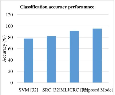
dataset is composed of class variable from various scene such as agriculture covering two-third, and forest and other vegetation covers the rest. The dataset is composed of 16 classes such as Alfalfa, Corn notill, Corn mintill, Corn, Grass pasture, Grass trees, Grass pasture moved, Hay windrowed, Oats, Soybean notill, Soybean mintill, Soybean clean, wheat, woods, Buildings Grass Trees Drives, Stone Steel Towers which is used for experiment analysis. The Indian pine image captured using AVIRIS sensor and its ground truth value is shown in Fig. 1, and Fig. 2, respectively. The dataset is composed of 10249 samples out of which only 10% of data is used for training the classification model. The calcification accuracy attained by proposed hyperspectral image classification performance over existing image classification [32] is shown in Table II and is graphically shown in Fig. 3. From figure and Table II, it can be seen the SVM based model [32] attain a classification accuracy of 77.83%, SRC based model [32] attain a classification accuracy of 82.19%, MLJCRC based model [32] attain a classification accuracy of 91.63%, and the proposed model attain an accuracy of
[image:6.595.313.523.95.271.2]95.44%. From overall result attained it can be seen the proposed model attain much better accuracy when compared with other state-of-art classification algorithm.
[image:6.595.320.530.300.476.2]Fig. 1. The Indian Pines image captured using AVIRIS sensor.
Fig. 2. The ground truth value of Indian Pines dataset.
Fig. 3. Graphical representation of classification accuracy performance attained by proposed model over existing hyperspectral image classification model.
0 20 40 60 80 100 120
SVM [32] SRC [32]MLJCRC [32]Proposed Model
A
cc
u
rac
y
(
%)
[image:6.595.304.545.509.707.2]International Journal of Innovative Technology and Exploring Engineering (IJITEE) ISSN: 2278-3075, Volume-9 Issue-2, December 2019
Table- II: Classification accuracy performance achieved by proposed model over existing hyperspectral
image classification model.
Classification model Accuracy (%) SVM based hyperspectral image
classification [32]
77.83
SRC based hyperspectral image classification [32]
82.19
MLJCRC based hyperspectral image classification [32]
91.63
Proposed hyperspectral image classification model
95.44
VI. CONCLUSION
This work carried out analysis of various state-of-art satellite image classification method. From analysis it is noted crop identification and classification using satellite images is challenging. Various methodologies using correlation filter, compressive, and machine learning technique has been used for identification and classification of crop using satellite images. However, each model has its own advantages and disadvantage. Further, carrying out comparative analysis among different approaches it is challenging due poor standardization of model. Further, the model should be designed to bring tradeoff among classification accuracy and computational complexity. Along with, the future model should consider classifying crops under dynamic or mixed pixel environment. For overcoming the research problem identified, this paper presented an efficient methodology that overcome the research problems. Experiment are conducted on standard dataset. The existing MLJCRC obtain an accuracy of 91.63% which is much higher than other existing model. The proposed model attain much superior accuracy of 95.44% when compared with MLJCRC. Thus, proposed model is much efficient when compared with existing hyperspectral image classification. Future work, this work aimed at refining the proposed model and evaluate the model considering different standard dataset and carryout comparative analysis over existing state-of-art crop identification and classification model using satellite image.
REFERENCES
1. Rosenzweig, C.; Elliott, J.; Deryng, D.; Ruane, A.C.; Müller, C.; Arneth, A.; Boote, K.J.; Folberth, C.; Glotter, M.; Khabarov, N.; et al. Assessing agricultural risks of climate change in the 21st century in a global gridded crop model intercomparison. Proc. Natl. Acad. Sci. USA 2014, 111, 3268–3273.
2. Gerland, P.; Raftery, A.E.; Ševˇcíková, H.; Li, N.; Gu, D.; Spoorenberg, T.; Alkema, L.; Fosdick, B.K.; Chunn, J.; Lalic, N.; et al. World population stabilization unlikely this century. Science 2014, 346, 234–237.
3. Whitcraft, A.K.; Becker-Reshef, I.; Justice, C.O. A framework for defining spatially explicit earth observation requirements for a global agricultural monitoring initiative (GEOGLAM). Remote Sens. 2015, 7, 1461–1481.
4. Fuhrer, J.; Gregory, P.J. Climate Change Impact and Adaptation in Agricultural Systems; CABI: Wallingford, CT, USA, 2014; ISBN 9781780642895.
5. Mahalanobis, A., Vijaya Kumar, B. V. K., & Sims, S. R. F. Distance-classifier correlation filters for multiclass target recognition. Applied Optics, 35(17), 3127-3133, 2013.
6. Kumar, B. V., Mahalanobis, A., & Juday, R. D. Correlation pattern recognition (Vol. 27). Cambridge: Cambridge University Press, 2015.
7. Palchowdhuri, Y.; Valcarce-Diñeiro, R.; King, P.; Sanabria-Soto, M. Classification of multi-temporal spectral indices for crop type mapping: A case study in Coalville, UK. J. Agric. Sci. 2018, 156, 24–36.
8. Azar, R.; Villa, P.; Stroppiana, D.; Crema, A.; Boschetti, M.; Brivio, P.A. Assessing in-season crop classification performance using satellite data: A test case in Northern Italy. Eur. J. Remote Sens. 2016, 49, 361–380.
9. Tan, Kun & Wang, Xue & Zhu, Jishuai & Hu, Jun & Li, Jun. (2018). A novel active learning approach for the classification of hyperspectral imagery using quasi-Newton multinomial logistic regression. International Journal of Remote Sensing. 39. 3029-3054. 10.1080/01431161.2018.1433893.
10. Lowe, Amy, Nicola Harrison and Andrew P. French. “Hyperspectral image analysis techniques for the detection and classification of the early onset of plant disease and stress.” Plant Methods (2017). 11. L. Wang, Y. Feng, Y. Gao, Z. Wang and M. He, "Compressed Sensing
Reconstruction of Hyperspectral Images Based on Spectral Unmixing," in IEEE Journal of Selected Topics in Applied Earth Observations and Remote Sensing, vol. 11, no. 4, pp. 1266-1284, April 2018.
12. A.C. Braun, U.Weidner, and S. Hinz. Classification in high-dimensional feature spaces – assessment using SVM, IVM and RVM with focus on simulated EnMAP data. IEEE Journal of Selected Topics in Applied Earth Observations and Remote Sensing, 5(2):436{443, April 2012.
13. Tattaris, M.; Reynolds, M.P.; Chapman, S.C. A Direct Comparison of Remote Sensing Approaches for High-Throughput Phenotyping in Plant Breeding. Front. Plant Sci. 2016, 7, 1131.
14. Rasti, Behnood & Scheunders, Paul & Ghamisi, Pedram & Licciardi, Giorgio & Chanussot, Jocelyn. (2018). Noise Reduction in Hyperspectral Imagery: Overview and Application. Remote Sensing. 10. 482. 10.3390/rs10030482.
15. J. Xia et al., "Hyperspectral Identification and Classification of Oilseed Rape Waterlogging Stress Levels Using Parallel Computing," in IEEE Access, vol. 6, pp. 57663-57675, 2018.
16. A. Farooq, J. Hu and X. Jia, "Analysis of Spectral Bands and Spatial Resolutions for Weed Classification Via Deep Convolutional Neural Network," in IEEE Geoscience and Remote Sensing Letters, vol. 16, no. 2, pp. 183-187, Feb. 2019.
17. Sun, Mengmeng & Chunyang, Wang & Wang, Shuangting & Zhao, Zongze & Li, Xiao. (2018). A New Semisupervised-Entropy Framework of Hyperspectral Image Classification Based on Random Forest. Advances in Multimedia. 2018. 1-27. 10.1155/2018/3521720. 18. W. Yang, C. Yang, Z. Hao, C. Xie and M. Li, "Diagnosis of Plant Cold
Damage Based on Hyperspectral Imaging and Convolutional Neural Network," in IEEE Access, vol. 7, pp. 118239-118248, 2019. 19. Y. Gao and Y. Feng, "Classification of spectral compressive
hyperspectral images using morphological profiles," 2017 Asia-Pacific Signal and Information Processing Association Annual Summit and Conference (APSIPA ASC), Kuala Lumpur, 2017, pp. 1712-1718. 20. Mahalanobis, A., Carlson, D. W., & Kumar, B. V. Evaluation of
MACH and DCCF correlation filters for SAR ATR using the MSTAR public database. In Aerospace/Defense Sensing and Controls (pp. 460-468). International Society for Optics and Photonics, 2014. 21. Luo, Fulin & Huang, Hong & Liu, Jiamin & Ma, Zezhong. (2017).
Fusion of Graph Embedding and Sparse Representation for Feature Extraction and Classification of Hyperspectral Imagery. Photogrammetric Engineering & Remote Sensing. 83. 37-46. 10.14358/PERS.83.1.37.
22. Y. Gan, F. Luo, J. Liu, B. Lei, T. Zhang and K. Liu, "Feature Extraction Based Multi-Structure Manifold Embedding for Hyperspectral Remote Sensing Image Classification," in IEEE Access, vol. 5, pp. 25069-25080, 2017.
23. Han, D., Li, X., Mohapatra, R. N., Michalak, M., Nashed, Z., & Muise, R. (2008, May).Refining Algorithms in Correlation Filter Design for
Target Detection.In Image and Signal Processing,
2008.CISP'08.Congress on (Vol. 1, pp. 231-238).IEEE.
24. Sadgrove, Edmund & Falzon, Gregory & Miron, David & Lamb, David. (2018). Real-time object detection in agricultural/remote environments using the multiple-expert colour feature extreme learning machine (MEC-ELM). Computers in Industry. 98. 183-191. 10.1016/j.compind.2018.03.014.
26. Dinc, S., &Bal, A. A statistical approach for multiclass target detection.Procedia Computer Science, 6, 225-230, 2016.
27. Chanda, B., & Majumder, D. D.Digital image processing and analysis. PHI Learning Pvt. Ltd., 2016
28. Xiong, Jun & Thenkabail, Prasad & Gumma, Murali & Teluguntla, Pardhasaradhi & Poehnelt, Justin & Congalton, Russell & Yadav, Kamini & Thau, David. (2017). Automated cropland mapping of continental Africa using Google Earth Engine cloud computing. ISPRS Journal of Photogrammetry and Remote Sensing. 126. 225-244. 10.1016/j.isprsjprs.2017.01.019.
29. Teluguntla, Pardhasaradhi & Thenkabail, Prasad & Oliphant, Adam & Xiong, Jun & Gumma, Murali & Congalton, Russell & Yadav, Kamini & Huete, Alfredo. (2018). A 30-m Landsat-derived Cropland Extent Product of Australia and China using Random Forest Machine Learning Algorithm on Google Earth Engine Cloud Computing Platform. ISPRS Journal of Photogrammetry and Remote Sensing. 144. 325-340. 10.1016/j.isprsjprs.2018.07.017.
30. Guan, Lixin, Weixin Xie and Jihong Pei. “Segmented minimum noise fraction transformation for efficient feature extraction of hyperspectral images.” Pattern Recognition 48 (2015): 3216-3226.
31. Mahalanobis, A., Kumar, B. V., & Sims, S. R. F. Distance classifier correlation filters for distortion tolerance, discrimination, and clutter rejection. In SPIE's 1993 International Symposium on Optics, Imaging, and Instrumentation (pp. 325-335). International Society for Optics and Photonics, 2013.
32. J. Yang and J. Qian, "Hyperspectral Image Classification via Multiscale Joint Collaborative Representation With Locally Adaptive Dictionary," in IEEE Geoscience and Remote Sensing Letters, vol. 15, no. 1, pp. 112-116, Jan. 2018.
AUTHORSPROFILE
Girish Babu M C received the B.E degree in Computer
Science & Engineering in 2004, M.Tech in 2009 from Visvesvaraya Technological University. He is research scholar in the field of Image processing at Visvesvaraya Technological University India.
Dr. Padma M C i received the B.E degree in Computer