White Rose Research Online URL for this paper: http://eprints.whiterose.ac.uk/5008/
Monograph:
Karikari, I.B., Stillwell, J. and Carver, S. (2002) GIS Application to Support Land Administration Services in Ghana: Institutional Factors and Software Developments. Working Paper. School of Geography , University of Leeds.
School of Geography Working Paper 02/02
[email protected] https://eprints.whiterose.ac.uk/
Reuse
Unless indicated otherwise, fulltext items are protected by copyright with all rights reserved. The copyright exception in section 29 of the Copyright, Designs and Patents Act 1988 allows the making of a single copy solely for the purpose of non-commercial research or private study within the limits of fair dealing. The publisher or other rights-holder may allow further reproduction and re-use of this version - refer to the White Rose Research Online record for this item. Where records identify the publisher as the copyright holder, users can verify any specific terms of use on the publisher’s website.
Takedown
If you consider content in White Rose Research Online to be in breach of UK law, please notify us by
WORKING PAPER 02/02
GIS Application to Support Land
Administration Services in Ghana:
Institutional Factors and
Software Developments
Isaac Bonsu Karikari,
John Stillwell
and Steve Carver
School of Geography
University Of Leeds
LS2 9JT
ABSTRACT
In June 1999, the Ghanaian Government launched a new land policy document that
sought to address some fundamental problems associated with land administration and
management in the country. The document identified the weak land administration
system as a particular problem and recommended the introduction of computer-aided
information systems in the ‘lands sector’. In 2001, the Government made further
proposals to prepare and implement a Land Administration Programme (LAP) to
provide a better platform for evolving an efficient land administration that would
translate the ‘National Land Policy’ into action. Thus, an up-to-date land information
system (LIS), supporting efficient management of land records, is to be constructed,
which provides a context for the research reported in this paper.
We document two aspects of our research on the adoption of GIS by the Lands
Commission Secretariat (LCS) which form part of a pilot project in GIS diffusion.
Part one of the paper mainly outlines the empirical results arising from fieldwork
undertaken during 2001 to determine the information and GIS requirements of the
LCS in relation to their routine administrative processes and to identify the critical
factors that are required to ensure that any new GIS applications are successfully
embraced. Part two explains the prototype software system developed using ArcView
3.2 and Access that provides the LCS with a means to automate some of the routine
administrative tasks that they are required to fulfil. The software has been modified
and upgraded following an initial evaluation by LCS employees also conducted as
part of the fieldwork in Accra.
Keywords
Land administration; diffusion of geographic information systems; Ghana; Accra
TABLE OF CONTENTS
Page
CONTENTS
ABSTRACT ii
LIST OF TABLES iv
LIST OF FIGURES iv
LIST OF BOXES v
LIST OF PLATES v
1 Introduction 1
2 GIS Diffusion 2
3 Land Administration in Ghana 4
3.1 Land Ownership 4
3.2 The Lands Commission Secretariat 6
3.3 Progress Towards GIS Adoption and Land Policy 7
4 GIS Implementation in the Accra LCS 10
4.1 Strategies and Methodologies for Data Collection 11
4.2 Questionnaire Surveys 12
4.3 Questionnaire Responses: Institutional Issues 14
4.4 Questionnaire Responses: Application Issues 17
5 Results from the Critical Success Factor (CSF) Methodology 20
5.1 Applying the Methodology 20
5.2 Critical Success Factors Identified 35
5.3 General Observations and Problems Encountered 37
5.4 Major Findings and Discussion 39
5.5 Implications for GIS Implementation in the Accra LCS 46
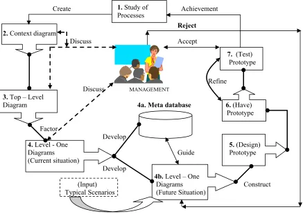
6 The LANDAMIN Prototype Software 49
6.3 The Architecture of the LANDAMIN Prototype Software 71
6.4 ArcView 3.2 User Interfaces 72
6.5 The Linked ArcView and Microsoft Access Interfaces 74
6.6 The Microsoft Access Interfaces 78
7 Respondents Reaction to Initial Prototype Software 80
8 Conclusions 83
References 86
Appendix 1: Scoring ‘Factors’ 89
Appendix 2: Questionnaires for Key Decision Makers /Technical Staff (Part 1) 90
Appendix 3: Questionnaires for Key Decision Makers /Technical Staff (Part 2) 96
Appendix 4: The Prototype Users Evaluation Form 103
Appendix 5: Initial Features of the Prototype Software for Testing in the Accra LCS
(September 2001) – ArcView 3.2 Interface 110
Appendix 6: Summary of Individual Respondent’s Views on Software Applications
(September 2001) – ArcView 3.2 Interface 111
LIST OF TABLES
1. Use of selected software packages by respondents (September 2001) 17
2. ‘Factors’ emerging out of brainstorming sessions and their initial scores 25
3. Reviewed ‘Factors’ and their prioritisation by respondents 31
4. Sample data set in ArcView 3.2 71
5. Sample data set in Microsoft Access 72
6. Overview schema of the menu structure in ArcView 3.2 (Project window) 73
LIST OF FIGURES
1. The Critical Success Factor (CSF) pilot study 22
2. Juxtaposing ‘Activities’ and ‘Factors’ (The CSF matrix before validation) 27
3. The data flow analysis (DFA) and prototype design pilot study 51
4. The data flow diagram - ‘Context’ 53
5. The data flow diagram – ‘Top Level (The Searches process) 55
7. The data flow diagram – Level One (Future Situation) 64
8. Detailed architecture of the LCS prototype software (LANDADMIN) 69
9. Site plans selection via themes 74
10.Site plans selection via input of plot number 74
11.Linking ArcView to Microsoft Access 75
12.Microsoft Access – meta data structure 77
13.Lessees general information on Achimota Residential Area 78
14.Attribute information as part of search report 79
15.Link to the Internet from Access to the Ghana home page 80
LIST OF BOXES
1. Storage is a problem in the Accra LCS
2. Why the CSF was chosen 23
3. Data dictionary for ‘Processes’ (Searches) 58
4. Data dictionary for ‘Flows’ (Searches) 59
5. Data dictionary for ‘Stores’ (Searches) 60
LIST OF PLATES
1. Registers (showing how information is presently stored ) 7
2. Participants to the fieldwork exercise (August – September 2001) 10
3. Plotting at the Greater Accra Region Records Office (GARRO) 13
4. Brainstorming session during fieldwork (September 2001) 19
5. Validation session (September 2001) 21
6. Review with top management 32
7. Legacy left by GERMP 33
8. Sorting at the Search Office (September 2001) 54
9. Legacy left by GERMP (equipment heavily underutilised) 67
GIS Application to Support Land Administration Services in Ghana:
Institutional Factors and Software Developments
PART ONE
1 Introduction
In Ghana, as elsewhere in the world, land is a unique resource of fixed location,
incapable of expansion in supply (except in cases where, marginal increases have
been made through reclamation). The necessity for efficient and effective
management of this limited resource is of paramount importance. Both land
administration and management involve land registration and it has been recognised
that improvements to land registration systems and the establishment of land
information systems (LIS) or geographic information systems (GIS) are important
catalysts for development in less developed countries. This position is recognised by
the Global Strategy for Shelter for the Year 2000 (UNCHS, 1990) that recommends
the establishment of efficient land registration and GIS as a priority area of national
policy action for all countries.
In this paper, we are concerned with the diffusion of GIS into organisations in a less
developed country. Our attention is focused on both institutional factors and technical
developments, recognising that the transfer of innovations (diffusion) is a difficult and
complex process, only likely to succeed if it becomes a part of the daily lives of the
organisation(s) involved. Carter (1989) defines GIS as an “institutional entity reflecting an organisational structure that integrates technology with a database, expertise and continuing financial support over time”. This view is shared by Chan and Williamson (1999) who suggest the elements of this perception should include
data, information technology, standards, people with GIS expertise and the
organisational setting. The research in this paper adopts Carter’s definition as being
relevant to the land sector in general and to the Accra Lands Commission Secretariat
(LCS) in particular. The paper assumes ‘land administration’ to be the process
whereby land, and information about land, may be effectively managed. Land
administration therefore includes identifying those people who have interest in real
estate and information about those interests such as the nature and duration of rights
improvements, ownership and value. The term land administration is restricted here to
ownership means and land taxation and does not include the wider issues involved in
optimising the use of land as a resource (UNCHS, 1990). This distinguishes ‘land
administration’ from ‘land management’ which is the process of managing the use
and development of land resources in a sustainable way.
The paper highlights some of the characteristics of Ghana’s lands sector from the
perspective of the Accra Lands Commission Secretariat (LCS), the agency
responsible for the administration of public lands in Accra (Section 3). Thereafter, we
report the results of using a suite of methodologies to identify the information
requirements of the Lands Commission Secretariat (LCS) for GIS use (Section 4) and
the factors that are deemed to be critical in successful implementation (Section 5).
Section 6 outlines the technical development of a customised administrative support
system called ‘LandAdmin’ that has been designed to automate several of the routine land administrative tasks that the LCS is required to undertake on a routine basis. The
prototype software, which has a number of selected features, has been demonstrated
in the LCS as part of the strategy of gaining acceptability prior to adoption. We report
on the initial evaluation of the prototype by LCS employees (Section 7) and show
how modifications and extensions have been incorporated. However, before the
results of the fieldwork relating to the institutional context and the prototype software
are discussed in detail, we provide a broader perspective by reviewing the extant
literature on GIS diffusion.
2 GIS Diffusion
Like the definition of the term GIS itself, the word diffusion has various meanings. Zeltman et al. (1973) define it as the process of communicating a novelty to and among the population of potential users who might choose to adopt or reject it.
Onsrud and Pinto (1991) helps to provide an understanding of the factors and
processes underpinning adoption, implementation and utilisation of geographic
information technologies. These indicate that innovation, communication, adoption
over time and the social system are the four main elements in the diffusion process;
and that innovation is an idea, practice or object perceived as new by an individual,
group or organisation. For technological innovation to diffuse faster, it must a have a
low degree of complexity, a high degree of ‘trialability’ before commitment, a high
degree of visibility to other potential adopters, a high degree of compatibility with
existing values, past experiences and needs of potential adopters, and finally have
relative advantage over the methods it supplants (Rogers, 1983)
Eason (1988) has indicated that the sequence of stages – what he terms the traditional
data process approach – in implementing GIS in organisations represents a ‘linear
view of diffusion’. These stages include project selection, a feasibility study through
trials (prototyping) and implementation. Campbell and Masser (1995) acknowledge
that this may define implementation narrowly as users have not been fully involved.
Eason (1988) had accepted this, criticising the attempt to merely involve users as they
have not really been practically involved, “especially as there is limited time that is often available for users to assimilate and contribute to the complex and highly technical documentation with which they are confronted” (Campbell and Masser, 1995). There is, therefore, a need to gain organisational and user acceptance of the technology, placing emphasis on participative approaches to implementation
characterised by user-centred design values. According to Eason, such a philosophy
starts with the supposition that it is the organisational rather than technological issues
that are most likely to endanger the effective implementation of computer-based
systems. He accepts that such a philosophy does not deny the technological
component of such systems, even though, placing too much emphasis on this element
may be counter-productive. Campbell and Masser (1995) insist that user involvement
must not be restricted to symbolic consultations. Users ought to be given enough time
and skill “that they have real ownership of the project”.
Zwart (1990) notes that whilst computerisation may be necessary, most countries are
well advised to carry out a review of their current information practices. They need to
and data quality procedures. These activities do not rely on investments in high cost
technology, but mainly require an investment in people as individuals and in
organisations. “The time to decide as to whether to use computer-based schemes is when these organisations and management reforms are in place. They need not, and in most cases should not, go hand in hand as the common wisdom seems to suggest. In the meanwhile, by reforming your existing Land Information Management system before introducing the computer, you will have taken the major step to secure their success. You will also have minimised the risks and gained most of the benefits”
(Zwart, 1990). Keen (1981) has noted some interesting reactions by users to the implementation of computer-based systems. He notes that these include exploiting the
system designers’ lack of knowledge about the organisational environment and
therefore ensuring that the project ultimately does not succeed; undermining key
individuals in the project so that their trustworthiness is lost; and lying low so as to
avoid direct confrontation and thereby not fully playing a part in the project!
Finally, it is apparent that much of the reported research on GIS diffusion in the
developing world has either been ‘anecdotally based’ (research not conducted under
controlled conditions) or focused on retrospective single case studies of successful
implementations. There is little evidence to show the use of empirical methods in a
more organised study of GIS/LIS diffusion in developing countries. Much could be
learned from prospective studies as new classes of users learn about the possible
application of the new geotechnology tools to their fields. Thus, we conclude that in
evaluating the transfer of geographic information innovations, it is essential to take
into consideration the full process of adoption (Onsrud and Pinto, 1991).
3 Land Administration in Ghana
3.1 Land Ownership
Land administration in Ghana is complicated because of the existing land ownership
arrangements. In broad terms, the country has a land ownership system in which
customary tenures are distinguished from state land. Customary tenures comprise ‘absolute interests’ held by two main types of the land-owning community and may
occur through discovery of land or through conquest/war. The lands that are held by
these land-owning communities are termed ‘stool/skin’ and ‘family’ lands. The head
lands in trust for the subjects of the stool in accordance with customary law and
usage. The stool or skin symbolises the authority of heads of these traditional states
who are vested with managerial functions of the lands under their control. Members
of these two land owning groups who are subjects of stool/skin or family lands also
have ‘usufructuary rights’ - rights to use or dispose of use-rights over land, including the right to occupy, till or otherwise enjoy any ‘unappropriated’ portion of the stool or
skin land. There are also ‘private lands’ that emerge out of such transactions.
The second main type of land in Ghana is state or public land. Under Act 123, the
Administration of Lands Act, 1962, the Government was able to vest stool/skin lands
in the President by ‘executive instrument’ in what comes about as ‘split ownership’.
In this case, the Ghanaian Government manages the land and collects rent on behalf
of the customary landowner who retains the beneficiary or equitable rights in the land
rents emanating therefrom. On the other hand, through the exercise of the powers of
eminent domain (compulsory acquisition of land), the Government could also acquire
land, subject to the payment of compensation. This is provided under the 1992
Constitution through its enabling Act, Act 125 – the State Lands Act, 1962.
It has been the case in Ghana that obstacles arising out of inappropriate land tenure in
some areas, and poor land utilisation procedures in the country as a whole have
prevented investment in both agriculture and industry. This is one of the reasons why
there is a growing need for a better land administration and management throughout
the country. Other problems include that of land encroachments and multiple sales of
land that have led to environmental problems, disputes, conflicts and endless
litigation. Encroachments on public lands appear to engage the serious attention of
government. These encroachments sometimes involve building on lands without
regard to planning schemes prepared by government for such areas. In the Greater
Accra Region alone, almost all sites earmarked for various activities have been taken
over by the “encroachers”. The site for the Council for Scientific and Industrial
Research (CSIR) to serve as a scientific instrumentation centre at Otinshie-Accra has
been affected by encroachment, forcing government to release a vast portion of the
land back to the owners. The status of these owners, like many others, cannot be
readily ascertained due to conflicting claims that have to be eventually settled in the
Sports Complex at Achimota, the site for Police Depot and College at Ofankor. The
residential and industrial sites at Ofankor and the site for Ambassadorial Enclave at
East Legon have all also been heavily affected.
‘There are indeterminate boundaries resulting directly from lack of reliable
maps/plans and the use of unapproved, old or inaccurate maps’. This has led to land
conflicts and litigation between stools, skins and other land owning groups. The
government has not utilised large tracts of land acquired compulsorily neither has
compensation been paid for most of the acquired lands. Landowners have been left
‘landless’ having been denied their source of livelihood.
The lack of adequate functional and co-ordinated geographic information systems and
networks as well as of transparent guidelines have been identified as one of the
problems to be tackled. This requires that the land agencies ‘maintain up to date
scientific data, maps and plans; geographic database and information systems’.
3.2 The Lands Commission Secretariat
The Lands Commission is a public institution set up under the Lands Commission Act
of 1994 (Act 483) in accordance with Article 258 of the 1992 Constitution of Ghana.
It is mainly charged with the responsibility of managing public lands and any lands vested in the President of the Republic. It has a Secretariat, the Lands Commission Secretariat (LCS) that carries out its functions. It is both a provider and user of
geographic information. The current information system for the LCS comprises a
complex set of requirements with the primary purpose of using geographic
information related to creating and maintaining an inventory of land data. The LCS is
expected to respond to a government mandate to manage public land in the most
effective and efficient manner possible and to advise the Government on land use
change and capability. This involves identifying land problems, determining strategies
for land reform, monitoring land use change on public land, developing alternative
plans and finding solutions to a myriad of land problems, including encroachments on
public land.
The LCS uses various themes that may include land use on land parcels as geographic
scales (mostly 1:2,500 for urban areas) and other tabular listings mostly in hardcopy.
The large volume of land data requires an equally large amount of space for data
storage (Plate 1). Generally, the manual system can be said to be a ‘clerical support
system’. Computers are mainly used for word processing. Even though the Accra LCS
has begun to build its databases using Microsoft Access, the automation process
occurs at the very end. For instance, the rent collection branch still uses the manual
approach in the collection of rents and only sends information to the ‘computer room’
for input into Access. The input of rent data in the computer that occurs at the end of
the manual rent collection process is not bringing optimal results. The application to
be developed in this research will be a fully automated administrative support system.
This characteristic adds to uncertainty in specifying information requirements.
Plate 1: Storage is a problem in the Accra LCS (September 2001)
3.3 Progress Towards GIS Adoption and Land Policy
Literature is available on various themes relating to land in Ghana, ranging from
discussions on institutional and legal issues associated with land delivery to surveys
(Ollennu, 1962; Acquaye and Associates, 1989; Brobby, 1991; 1992; Kasanga, 1990;
Kasanga et al., 1996; Larbi, 1995; 1996; CDD, 2000; Somevi, 2001). Almost all of these studies with the exception of CDD (2000) and Somevi (2001) have failed to
recommend the need to use computers or capture, analyse and disseminate
land-related information using GIS capabilities. However, there are some discussions
(Mills et al, 1997; http://glacier.gg.rhbnc.ac.uk/kumasi/Inception/inception.html;
GERMP, 1999) of projects with GIS components such as KUMINFO and GERMP
that were initiated by the international donor community and that related to the wider
issues involved in optimising the use of land as a resource in Ghana.
‘KUMINFO’, for instance, is the GIS component of the Ghana’s Natural Resource
Management Project aimed at addressing critical issues on environmental conditions
confronting inhabitants of peri-urban Kumasi in Ghana. It is based on a pre-project
prototype, ‘PUDSI’ an acronym for Peri-Urban Demonstrator for Spatial Integration
with programmed interfaces that is based on ArcView 3.2 and allows the display,
querying and analysing of spatial and non-spatial data for Kumasi. It also allows easy
access to research topics. The system runs in Kumasi within the Institute of
Renewable Natural Resources (IRNR), a constituent unit within the University of
Science and Technology (UST), Kumasi with parallel systems at the Natural
Resources Institute, University of Greenwich and the Royal Holloway College,
University of London. Reports indicate that the ‘lack of clearly pre-defined user-needs
and requirements, and the lack of available data for Kumasi limited the development
of PUDSI’.
In 1991, the Government approved the Ghana Environmental Resource Management
Project (GERMP) that aimed to implement the National Environmental Action Plan
(NEAP) under the co-ordinating role of the Environmental Protection Agency (EPA).
The Lands Commission, together with the Land Administration Research Centre
(LARC) of the University of Science and Technology (UST) Kumasi, were
responsible for the land ownership aspects under the Land and Water Management
Component of the project, under which the LCS inherited some GIS equipment that is
still available for use. Thus, although the KUMINFO and GERMP projects have not
focused on the lands sector directly, agencies such as the LCS have been involved
because of the land ownership and mapping issues that have arisen in these projects.
remained very slow in Ghana’s lands sector agencies. This can be attributed to
inherent difficulties with the technology itself and with problems of data conversion
that confront organisations in this sector. Even though the Survey Department under
GERMP used computers to perform land survey computations, the implementation of
GIS has proved difficult. The awareness of the potential of this technology appears to
be growing yet the technical, economic and institutional problems are yet to be
addressed in practice.
In 1999, the Government of Ghana initiated a ‘Land Policy Document’ aimed, among
other things, at establishing and developing a land information system (LIS) and
networks between related agencies. It was noted that the basis for better management
of information, and for considerable improvement of information within the lands
sector might be brought about by evaluating and appraising existing tasks, discarding
unnecessary procedures and developing a better use of resources (UNCHS, 1990).
One of the main objectives has been to lessen duplication in the storage of
information and to restore registers physically damaged through handling (Plate 2)
with electronic versions. In 2001, the Government made proposals to prepare and
implement a Land Administration Programme (LAP) to provide a better stage for
evolving an effective and efficient land administration that would translate, within a
holistic environment, the National Land Policy into action. The proposed project is
consistent with the World Bank’s Country Assistance Strategy of March 2000 for
Ghana.
Thus, whilst there have been attempts to apply GIS in Ghana, several of which have
had implications for the lands sector, there has been no attempt to address the specific
issue of using GIS to support the administration of land in the country. One of the
dangers in this context is that GIS technologies may be adopted without critical
analysis and without consideration of the socio-economic and institutional
background of the land agencies concerned and without the need to involve the
indigenous experts from the very outset. It is our view that whilst some financial and
technical support for successful GIS diffusion in the lands sector is required,
governments in countries such as Ghana must now claim and expect to receive more
control over project design and execution. In most cases (as seen with the GERMP
technology transfer is concerned, the end of most projects has brought to the fore such
stark realities. It appears noticeable that, after the expatriate experts involved in
technological transfers have left, no-one remains with the commitment to continue
where the experts left off and equipment is left without the required maintenance. It
would therefore be more sensible to establish a national prerequisite to develop
indigenous expertise. We concur with the view that if GIS is to be introduced, it must
be “developed, modified and controlled by indigenous people who understand the social, economic and political context of the situation as well as the technical capabilities of GIS” (Taylor, 1991).
Plate 2: Registers (showing how information is presently stored in the Accra LCS)
4 GIS Implementation in the Accra LCS
The situation in Ghana outlined in the previous section provides the context for
undertaking a pilot study of the institutional environment within which GIS is to be
implemented in the lands sector. In this section of the paper, we report on the
fieldwork carried out at the LCS during the summer of 2001 with the objective of
determining the factors deemed most critical for achieving successful adoption of
institutional processes of GIS adoption and use even though technical issues relating to the development of the software system are also essential. One of the primary
objectives has been to identify the range of factors relevant to GIS diffusion in the
Accra LCS through empirical study. The ethnic background of Isaac Bonsu Karikari
as a Ghanaian who has been involved in land administration for well over twelve
years, at which period he headed three of Ghana’s ten regions as Regional Lands
Officer, the last being the Greater Accra Regional office of the LCS, was particularly
necessary in gaining the support of the organisation and the willingness of the
workforce to collaborate in the pilot project.
4.1 Strategies and Methodologies for Data Collection
It was necessary to develop a strategy for data collection and analysis in order to
achieve the objectives of:
• understanding the organisational issues confronting the LCS that might
impact on GIS adoption ;
• determining the factors that are critical for the successful implementation of GIS; and
• identifying the functional needs of the LCS in relation to GIS
In order to achieve the first of these objectives and establish the organisational
context, we adopted the approach of asking (through questionnaires) a selection of senior managers and technical staff to give independent opinions about the various
characteristics of the LCS, the results of which are presented in Section 4.3. Similarly,
questionnaires were used to obtain information from respondents to fulfil the third
objective and to establish the (functional) needs of the LCS with respect to GIS
(Section 4.4). Brainstorming sessions were carried out and the critical success factor (CSF) methodology was used to achieve the second objective of prioritising those
factors deemed by respondents to be the key factors for successful GIS
implementation. We report on the results of the application in section 5. In section 6,
we present a prototype application of GIS to support various administrative services.
A methodology known as data flow analysis (DFA) was used to identify the software
requirements and the results of the DFA are also reported in this section.
Respondents’ reactions to the prototype software were obtained by using an
4.2 Questionnaire Surveys
The questionnaire for eliciting organisational requirements was designed to determine the characteristics of the Accra LCS and covered issues such as wage
levels, inter-personal and individual behaviour, conflicts, management style, authority
definition and hierarchy et cetera. Overall eighteen questions were posed. Appendix 2 details the structure and results obtained from the questionnaire. With the application
level questionnaires, the aim was to determine the application requirements such as
users competence with selected and widely used software such as Word and GIS tools
such as ArcView, training needs, storage space, data needs etceteras. Twenty-three such questions were asked. Appendix 3 details the structure and results obtained at
this level.
These questionnaires were administered to two types of respondents, namely 15
respondents at the middle or line management level and five respondents at the top
management or policy level. The evaluation of responses to questionnaires by top
management was delayed until initial requirements from the middle level had been
obtained1. It is these initial requirements that are evaluated to determine the characteristics of the LCS. Both open and closed questions were used in combination
for eliciting staff responses. The use of open questions safeguards against interview
prejudices that would have been achieved if only closed questions were used. To
minimise errors of interpretation, the responses to open questions were condensed in
the questionnaire (Flynn and Warhurst, 1994).
Nine males and six females (of the middle level) fully participated in the fieldwork
exercise. The mean number of years’ experience for the middle level management is 9
per person, with values ranging from 2 to 29 years’ experience on the job. The job
titles of the respondents included: Senior Lands Officer (1); Lands Officer (2);
Assistant Lands Officer (7); Principal Inspector of Lands (3); Assistant Chief
Technical Officer (1); and Senior Technical Officer (1). The respondents are an
appropriate representation of the LCS workforce and include all types of staff who
will be involved in GIS implementation (Plate 3).
1
Plate 3: Participants to the fieldwork exercise (August/September 2001)
The questionnaires were administered after respondents had gone through a
brainstorming session on the CSF methodology lasting three hours. The brainstorming
sessions introduced the respondents to the research and the interview process and to
prepare them for what lay ahead. The purpose of asking individual respondents to
complete these questionnaires was to identify the elements that the respondents think
will ensure success in GIS implementation, based on their personal judgements. The
approach of administering open and closed questions outside the brainstorming
sessions therefore helped among others, in the detection of problems experienced by
the individual staff member.
With regard to top management, the same questionnaires were administered albeit in
interview sessions lasting up to an hour or more per interviewee. Their responses are
compared with those of middle level management in order to determine problem areas
that may arise in terms of GIS project implementation. It must be noted that the
context for the questionnaires is that of an early requirement determination stage in
the development and innovation process and they are therefore exploratory in nature.
4.3 Questionnaire Responses: Institutional Issues
Creating Awareness (Questions 1 – 3) The initial part of the questionnaire on
organisational issues was so designed as to create awareness among staff members in
positions to influence the attainment of the project’s objectives. Before the general
characteristics of the Accra LCS was determined, and as part of an attempt to create awareness on GIS implementation, therefore, the fifteen respondents were asked three questions that required their acceptance of the goal set by the Commission in GIS use.
They were also made aware of the crucial role GIS could play in the LCS whilst an
attempt was made to let them come to terms to the fact that the introduction of a
full-fledged GIS project may warrant a different way of doing things.It was necessary for
this to be done by staff members since there was the need for ensuring continuing
active support and interest. There was also the need to ensure internal consensus as
early as possible so that the machinery to maintain the GIS project could be
established.All respondents agreed with goal of “introducing a GIS that will support land management applications leading within five years to increased revenue base, efficiency and timely processes and high customer confidence in the Accra LCS work processes”2.
Nature of the LCS (Questions 8 – 14, 17 and 18): Other questions were designed to
determine the organisational set up of the LCS and other institutional problems or
bottlenecks such as personal behaviour and their impact on the image of the Lands
Commission. Of the 15 respondents, 10 (67%) thought the LCS was overstaffed; three
(20%) disagreed. The ten who agreed were of the opinion that excess workers in the
LCS have led to underemployment and minimal workloads. However, almost all
respondents (14 respondents representing 93%) agreed that wage levels were low and
that levels must relate to productivity. Twelve (80%) of the respondents saw conflicts
existing between the Estates Section of the Commission and the Legal Section with
10 (67%) citing a conflict situation existing between the Estates section and the
Accounts section. When asked further to determine where the conflict emanated from,
five respondents (33%) attributed it to leadership style and roles only, whilst three
(20%) related it to work processes (only) and three respondents to policy issues
(only). It would appear that improved pay and incentives and greater opportunities for
2
promotion have a strong part to play in the bid to introduce a full-fledged GIS into the
Accra LCS. The study also points to the fact that the LCS is badly in need of some
streamlining of its structures and processes or even some overhaul. The GIS project
has to take into account the potential impact of these factors, anticipate these
problems and modify the implementation path accordingly.
Management style (Questions 15): Management style appears to have been
detrimental over the years, as there have been few consultations between the
implementation of different programmes. Changes in user personnel (as happened in
20003) may create unstable user patterns (Davies, 1983). On management style, nine
respondents (60%) thought that leadership style for the last 10 years had been
autocratic whilst two respondents (13%) thought it had been paternalistic. Only one
thought it had been consultative; three did not respond. Whilst respondents attributed
this to lack of managerial talent, most felt that political interference was also to blame.
Discontinuity of management as a result of frequent changes for political reasons is
deemed highly disruptive. The GIS project characterised by a positive commitment on
the part of management and politicians will be crucial for its success in the Accra
LCS.
Authority definition/hierarchy and degree of decentralisation of operations
(Questions 15 and 16): Eleven respondents (73%) saw authority definition and
hierarchy as unclear. Only three (20%) insisted that it was clear; and one did not
respond. Our investigations reveal that a Deputy Executive Secretary has never been
appointed even though this was a Constitutional requirement. If the Executive
Secretary was indisposed, who acts? We concluded that the LCS would have to be
strengthened at different hierarchical levels and in various aspects relating to
management, planning and policy formulation. A GIS project with a clear and
well-defined institutional environment coupled with the right managerial arrangements and
attitudes will greatly enhanced prospects for success. This point brought to the fore an
3
investigation into the degree of decentralisation now existing. Fourteen respondents
(93%) believe that the Accra LCS must have a role distinct from the Head Office as
envisaged by the Lands Commission Act, Act 483. The lack of this clear role
re-enforced the respondents’ earlier view that the definitions of authority and hierarchy
in the LCS were unclear.
Political interference in the work of the LCS (Questions 4 - 7): Our investigations
also revealed thatthere is the lack of stability in the structure of the organisation due
to Government’s interventions, particularly in the appointment and removal of ‘top
brass’ in the LCS. The perceived political pressure on the LCS from the Ministry of
Lands and Forestry was therefore investigated. Three (20%) respondents deemed such
interference as positive, four (27%) saw it as negative with six (40%) being uncertain.
However, 11 respondents (73%) were emphatic in agreeing to the proposition that the
LCS must receive autonomy and be insulated from government control, whose role
must be catalytic only. Nine respondents (60%) agreed that all directions from
Government must be rooted through the National Lands Commission with three
(20%) disagreeing; two were unsure. A general conclusion may be drawn, as has
already been indicated, that the GIS project in the LCS will require strong and
sustained Government support if the project’s objectives are to be achieved. This is a
complex matter that ought to be handled and monitored carefully by the GIS project
manager. Government support in the allocation of human and financial resources or
through the workings of the administrative and political apparatus will be critical to
the Accra LCS GIS project’s success.
As the empirical study shows, with management control changing, uncertainty is high
and therefore this factor ‘adds’ to the level of uncertainty when introducing GIS.
Because uncertainties are generally high, this suggests the need for the LCS to begin
with a small pilot project preceded by a selected features prototype software that is
deliberately experimental in nature and that needs to be monitored closely for
eventual adoption. The next part of this paper will examine questionnaires
administered at the application level before discussions on the use of the CSF
methodology which seeks to establish which prioritised factors and their associated
activities are critical for GIS diffusion and implementation in the Accra LCS are
4.4 Questionnaire Responses: Application Issues
In terms of the technical process of land administration, there is an initial need to
studycritically the needs of the agencies involved in land administration, management
and planning. This will help to bridge the gaps in conceptual understanding between
the potential GIS users (staff in the LCS and other land agencies) and the GIS
developer. The design of information systems in this researchdepends not only onthe
development of concepts of performance (organisational issues) and but also the
functional needs (application issues) for these land agencies. This part of the paper
reports the results obtained from the questionnaire on application issues.
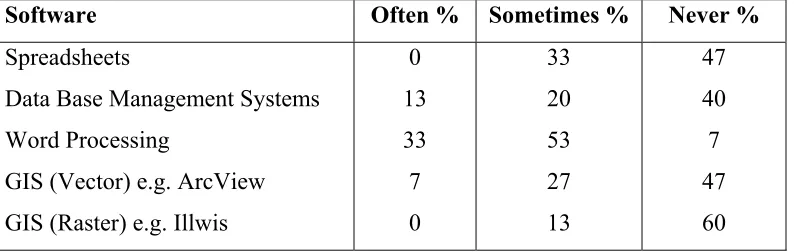
Training needs (Questions 1 - 7): Seven questions were asked of the 15 respondents
in order to determine the level of user experience with computers generally and with
the application proposed. Only four (27%) respondents used computers often, with
eight (53%) admitting using computers ‘sometimes’ (Table 1). Two have never used
computers before; one did not respond. No one had consistently used spreadsheets
before with five (53%) having sometimes used this software. Seven (47%) had never
used any spreadsheet before. It must be noted that 13 of the 15 respondents were
[image:23.595.93.490.507.633.2]university graduates.
Table 1: Use of selected software packages in the Accra LCS by selected respondents
(September 2001)
Software Often % Sometimes % Never %
Spreadsheets
Data Base Management Systems
Word Processing
GIS (Vector) e.g. ArcView
GIS (Raster) e.g. Illwis
0
13
33
7
0
33
20
53
27
13
47
40
7
47
60
Only seven percent of all respondents had heard about Knowledge Base Systems
these, only 4 (27%) had received some training in GIS4. To solicit commitment, all
the respondents admitted that upon the introduction of a full fledged GIS, training was
critical and that they were prepared to undergo training. Thirteen (87%) agreed to the
proposition that training must be tailored to suit the LCS needs and that all employees
must be computer literate. Two disagreed, citing reasons that not all staff members are
trainable. These characteristics suggest the need to build the LCS institutional
capacity. It is to be noted that none of the six women respondents had any training in
GIS and therefore development of organisational capacity must be designed to
involve women from the very beginning. This point is significant since it is proven
(even though not documented) that women are more likely to remain at work after
training. Other serious limitations solicited include no clear-cut training for staff and
some difficulty in information retrieval.
Work processes (Questions 8 - 15): When asked which work processes they wanted computerised most, the ‘searches’ procedure was awarded the highest total aggregated
score of 120 followed by rent assessment and collection (104) and plotting(s) – the
penultimate stage in the registration of deeds or leases (88)5 (Plate 4). The study
concluded that most activities are not programmed and procedures will have to be
streamlined and improved. For GIS implementation, it may require some
re-engineering in all aspects of the Commission’s work processes. This will require a
careful diagnosis in order to establish an overall strategy for change. Implementing
this agreed upon strategy will require a selective approach. Initially, a few more
critical problem areas would have to be tackled, as a comprehensive reform may be
seen as too ambitious and unworkable. It will therefore mean that issues that seriously
constrain the performance of the LCS and that are within the capacity to change
would have to be given priority. Public support for such a reform ought to be
solicited.
4
During the validation session, it came out clearly that only one had been actually trained in GIS and therefore fully understood the principles underlying GIS. The other three had received instructions on how to use ArcView 3.2
5
Respondents were asked to give scales ranging from 1 to 9 to the type of work, scale 9 being the most important. These were then totalled to arrive at the level of
Information needs (Questions 18 -17): All respondents agreed to the proposition that
information/data the LCS provides or uses must be seen as a corporate resource; 27%
suggested that this information should be subsidised with 20% advocating for its free
use; and 53% felt that it should be at market value. This has some implications for
GIS as corporate usage and pricing of information at market value would ensure that
duplication is removed and adequate financial resources are obtained to ensure
sustainability. It must be noted that for the LCS, the issue is not principally the
accuracy of information but that of automation to help speed up processing capacity.
This will place an enormous challenge to management as it seeks to redefine the
information system.
Plate 4: Plotting at the Greater Accra Regional Records Office (September 2001)
Data needs (Questions 20 - 23): On quality of maps, 20% were of the opinion that this was poor; 60% thought it was fair, with only 7% insisting it was good. None
thought the quality of data was poor. Thirty three percent thought the LCS data was of fair quality with 60% saying it was of good quality. When the question was put to
80-100%, 33% said it was 60-79% reliable, 27% (49-59% reliable) with only 7%
thinking it lay within the 20-39% range. On data reliability, none saw it as poor, with 20% considering it as of fair quality. Seventy three percent thought one could rely on
the data since reliability was good. In any case to be able to accurately determine the
reliability and quality of data, an inventory ought to have been conducted. The
research that was exploratory did not have the objective of doing this. What is certain
is that the LCS has devoted less attention to the problems of gathering and storing
basic data and of monitoring progress toward good record management objectives.
The use of GIS has the potential of providing land administrators with current
analysis of relevant data and moving forward to achieving optimum results.
Organisational needs (Questions 18 - 19): Eighty seven percent of the 15
respondents were of the opinion that GIS must be a unit/department within the LCS
‘so that there can be some permanent staff in the unit to see to the day to day updating
of spatial and attribute data’.
Based on these initial assessments, the study came to a conclusion that there is very
high uncertainty as to necessary and desirable requirements at the application level.
There was also a high uncertainty as to users’ ability to specify the correct
requirements and a fairly high uncertainty as to the ability of any analyst to convince
users to accept a new information system that may drastically change the usual way of
doing things. This suggests a discovery methodology in which requirements are
identified ‘iteratively’ as the application system evolves. The prototyping method is
therefore recommended as the primary methodology at the application level. We will
now discuss issues related to the factors necessary for GIS successful implementation
in the Accra secretariat.
5 Results from the Critical Success Factor (CSF) Methodology
5.1 Applying the Methodology
It has been noted elsewhere that the brainstorming method that is actually an asking strategy was used with the CSF method in obtaining ‘factors’ and associated ‘activities’ necessary for successful GIS implementation. Brainstorming sessions
comprising the fifteen respondents selected by the LCS management involved intense
brainstorming method was used in eliciting a variety of suggestions through an open
flow of ideas within the selected group of ‘experts’ (the respondents) and gave good
results (Wasmund, 1993). The discussions covered a wide range of factors and issues
necessary to meet the LCS goals such as maintenance, education and training and
leadership style. The research reported here therefore, develops a list of ‘factors’ with
their associated support ‘activities’ in order to provide a more broad understanding of
the drivers of GIS implementation success in the Accra LCS. The aim was not only to
gain a deeper understanding at the organisational level as to what factors are
important, but which ones will be given priority by the users themselves.
Brainstorming sessions (Plate 5) enabled the extension of the boundaries of the
problem space of participants and elicited non-conventional solutions (Davies, 1982).
Two such sessions were organised, the last being purposely for review and validation.
The sessions lasted approximately three hours per session.
Plate 5: Brainstorming sessions during fieldwork (August/September 2001)
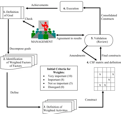
In Figure 1, the main components of the Critical Success Factor (CSF) method are
whilst single-ended ones indicate processes that are consulted by other processes. The
processes are followed rigidly (from definition of goals to execution) and show the
various criteria to be used. The CSF analysis is a method for eliciting significant
decisions on issues or on factors that are used in deriving requirements. The CSF
method basically allowed the creation of a project out of a problem definition. We decomposed the goal the LCS has set for GIS development into a comprehensive list
of sub-goals called ‘factors’. From this a list of ‘activities’ whose purpose is to obtain
these ‘factors’ and eventually accomplish the specified goal is ascertained. The
‘activities’ are executed in a project context leading eventually to the solution of the
original problem (Wasmund, 1993). This process will become clearer as we proceed.
[image:28.595.94.498.370.751.2]Box 1 explains why this methodology was chosen.
Figure 1: The Critical Success Factor (CSF) pilot study: study of performance needs
(modified from Wasmund, 1993)
Achievements
6. Execution 1. Definition
of Goal Consolidated
Check Constructs
Agreement to results 5. Validation
MANAGEMENT (Review)
Decompose goals
Amendments Final constructs
2. Identification
of Weighted Factors 4. CSF matrix and definition of Factors
x x
x
x x
Define
Construct
3. Definition of
Weighted Activities Initial Criteria for
Weights: • Very important (10)
• Important (8)
• Not so important (5)
In the next part of this paper, the six steps in the CSF methodology will be explained
and this is followed by an overview of the prioritised critical factors deemed
necessary by respondents for successful GIS implementation. This is then followed by
general observations made and the problems encountered in the entire exercise. Major
findings and discussions are presented and respondent characteristics are analysed to
determine the overall implication for GIS use.
Box 1: Why the CSF was used
The CSF methodology was chosen over the other methods such as the Business
System Planning (BSP) developed by IBM Corporation because:
• it required relatively little effort to arrive at critical factors for ensuring the LCS
systems’ success;
• it was a means to recognise and eliminate redundant activities in order to focus resources on crucial areas of concern to the Accra LCS; and
• the selected respondents were involved as it is a method of eliciting requirements
by asking them to define the factors that are crucial to success in performing their functions or in making decisions (Davies, 1982).
5.1.1 Step One: Definition of the LCS Goal
As previously noted, the goal of the LCS (as adapted from the mission statement of
the Lands Commission) to establish a full-fledged GIS implementation was included
as part of the discussions in the brainstorming sessions to help create awareness. The
rationale of the goal for GIS development is to build a system that delivers quickly
and is error-free as much as possible and that generates the expected revenue with
respect to land administration and management. It is worth mentioning here that we
tried to make the goal as exact as possible since succeeding steps depend heavily on
it. The purpose, scope and time frame have been included and are made as specific as
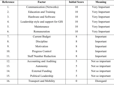
5.1.2 Step Two: Identification of Weighted Factors
The respondents are asked to identify ‘factors’ that will ensure the success of GIS
implementation through intense discussions and consensus building. The analyst(s)
had some factors that had been predefined for adoption6 even though respondents
were told to freely modify, discard or add to such factors as they pleased. They were
not only to identify but also prioritise such factors by initially awarding scores into
four main criteria, namely a score of 10 (Very Important); a score of 8 (Important); 5
(Not So Important); and 0 (Disregard). The requirement was to identify those factors
that are significant by system of ordering and deriving a set of ‘activities’ that might
support these ‘ordered factors’. The initial ordered or weighted factors identified by
respondents are shown in Table 2. The reference number has no significance except to
uniquely reference a factor whilst the order of factors is in alphabetical order within
each group. The meaning of every factor was given to enable the respondents to fully
understand each factor (Appendix 1). This initial selection and scoring process
allowed the relationship between the ‘factors’ and the respondents’ perception of GIS
success in the LCS to be analysed.
Respondents initially disregarded ‘transportation and mobility’ citing the fact that (for
administrative reasons) it was a general requirement and had nothing to do with the
use of GIS per se. These initial designations will change, as would be seen shortly,
after validation. It is important to state that we are, particularly, interested in the
critical ‘factors’ for GIS implementation. We will therefore intentionally delay
discussions on ‘factors’ until ‘activities’ to support them are first defined to help us
understand fully the methodology. Once the factors are chosen, their associated
activities can easily be identified and linked to them.
5.1.3 Step Three: Definition of Required Weighted Activities for the Accra LCS
In contrast to the first step of defining ‘factors’, the next step of defining activities
expresses the work to be performed that would satisfy one or several factors. Again,
most of these activities had been pre-defined by the researcher(s). However, there was
6
an additional activity that was added by the group since it appeared that the
‘Accounting and auditing’ factor had no related activity. The agreed upon ‘activity’ –
‘Have a proper accounting and cash control system’ is added in Italics (Figure 2).
The ‘activities’ as defined and discussed by the group is now presented as follows:
• Have supporting equipment. Equipment support, it was noted, is essential if one is to proceed in an efficient way. Of particular mention is efficient uninterrupted
power supplies (UPS) or generators to forestall stoppage of work due to frequent
power cuts that normally occur in the Accra LCS.
• Have maintenance of equipment schedule. Maintaining equipment was considered a strong prerequisite. It must be noted that the need to ensure adequate funds
extends to the operational phase of a GIS project as well. There should never be
an under-estimation of recurrent cost obligations, so that facilities would not
undergo rapid deterioration for want of adequate operating and maintenance
[image:31.595.100.499.446.745.2]funds.
Table 2: Factors emerging out of brainstorming sessions and their initial attendant
scores
Reference Factor Initial Score Meaning
1. 2. 3. 4. 5. 6. Communication (Networks)
Education and Training
Hardware and Software
Leadership style and support for GIS
Maintenance Remuneration 10 10 10 10 10 10 Very Important Very Important Very Important Very Important Very Important Very Important 7. 8. 9. 10. 11. Current Budget Discipline Motivation Progress Control
Staff Number Reduction
8 8 8 8 8 Important Important Important Important Important 12. 13. 14. 15.
Accounting and Auditing
Autonomy External Funding Political Leadership 5 5 5 5
Not so important
Not so important
Not so important
Not so important
• Establish a curriculum for training. Training was to be planned from the very outset and must be properly executed. The group acknowledged that it was wrong
for training programmes to be added at the very last moment. This requires that
the LCS must make provision for adequate resources for training and for skilled
trainees to be recruited. Female staff members have to be encouraged, as they are
more likely to stay after training. The closer the training is to the workplace the
better and therefore on-the-job training must be embraced where feasible
• Ensure motivation and commitment. It was agreed that realisation of the overall goal is a long-term process. Continued interest in and active support by individual
staff members who are in a position to ensure the attainment of the project’s
objectives must always be solicited. This, the group agreed, can be done through
provision of incentives and award schemes as ‘accelerators’. Incentives would be
needed to change human behaviour. Incentives should be linked to measurable
results attained by staff within set time frames.
• Relate remuneration to production targets. Related to the ‘motivation and commitment’ activity is that of linking remuneration to the level of production.
This would depend, to a large extent, on the autonomy status that the LCS is now
seeking. The group suggested that increases in pay must relate to performance and
not merely ‘to fight inflation’.
• Define and apply standards. Standards are required for land administration purposes in order to track and record land ownership details and for verification of
land data. Standardisation of input documentation is necessary to speed up
processing times and improve efficiency. It is also to ensure a smooth running of
the computer operations.
• Establish an upgrading programme on software. Existing systems would have to be upgraded continuously. This suggests that a timetable for changing usable parts
and systems must be drawn and followed.
• Make a reserve fund to recoup capital. There was a general consensus that it would be wise to set aside funds from the annual budget as a reserve fund to
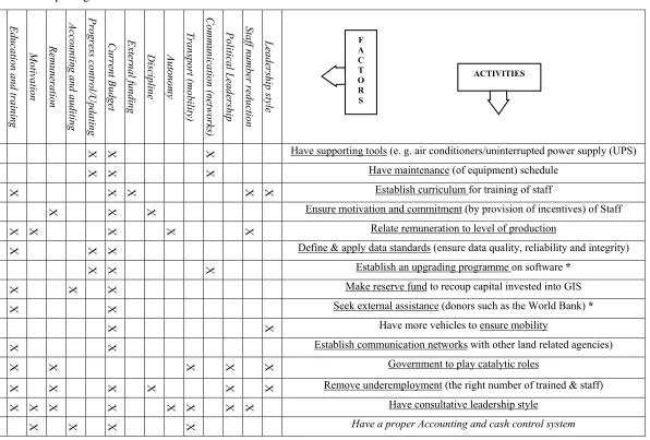
Figure 2: Juxtaposing activities and ‘factors’: the CSF matrix before validation H ar d w a re an d s of tw ar e Mai nt enanc e E d uc at io n a n d t rai ni n g Mo tiv a tion R em une ra tio n A cc o unt in g a n d au di ting P rogr es s c o nt ro l/U pdat ing Cur re nt B udge t E xt er nal f u ndi ng D is ci p lin e A u tono m y T ran sp o rt (m ob ili ty ) Co m m un ic a tion (n et wor ks ) P o lit ic a l L ead er sh ip St af f n u m be r r educ tio n L eade rs h ip s ty le
X X X X X Have supporting tools (e. g. air conditioners/uninterrupted power supply (UPS)
X X X X Have maintenance (of equipment) schedule
X X X X X Establish curriculum for training of staff
X X X Ensure motivation and commitment (by provision of incentives) of Staff
X X X X X Relate remuneration to level of production
X X X X Define & apply data standards (ensure data quality, reliability and integrity)
X X X X X Establish an upgrading programme on software *
X X X Make reserve fund to recoup capital invested into GIS
X X Seek external assistance (donors such as the World Bank) *
X X X Have more vehicles to ensure mobility
X X X X Establish communication networks with other land related agencies)
X X X X X Government to play catalytic roles
X X X X X X Remove underemployment (the right number of trained & staff)
X X X X X X X X Have consultative leadership style
X X X X X X Have a proper Accounting and cash control system
• Seek external assistance. Initially, this activity was identified as comprising two components namely: seeking external funds for initial GIS take off and the use of
foreign consultants. The group dropped the former since equipment through the
GERMP was already in place. The issue of foreign consultants was also dropped
since respondents were of the view that there was in-house capacity to meet the
demands of the project even though refresher courses were a necessity for such
experts. The use of local consultants was an accepted alternative to the group, one
of which had already been contracted.
• Have more vehicles to ensure mobility. The Estates section of the Commission is to be strengthened with the allocation of vehicles specifically for checking
unofficial changes of use and for upgrading addresses of lessees to facilitate rent
collection.
• Establish communication networks. It is important that the Local Area Network (LAN) already installed is made optimally operational to enable corporate-wide
storage and retrieval of information for internal use by all sections. The LCS was
(in consultation with other agencies) to have on the drawing board the possibility
of linking to agencies such as the Survey Department, the Administrator of Stool
Lands and the Land Valuation Board that are in close proximity to it and that need
to be networked as well.
• Remove underemployment. The LCS is expected to undertake a programme of removing excess staff by a phased-out policy of voluntary retirement of
non-essential staff. Staff members who cannot be trained, it was agreed, must be
retired with due compensation.
• Government to play catalytic roles. This activity relates to perceived Government interference in the work of the LCS by the Ministry of Lands and Forestry. The
issue of the mode of appointment of the Executive Secretary particularly came
under intense discussions. The group deems the rapid rotation of personnel in top
posts to be highly detrimental and noted that the practice if not stopped, could
affect the project’s goals in the long run.
• Have consultative leadership style. It was agreed that, managerial problems are often the root cause of GIS implementation delays and cost overruns. Good
managers are a major determinant to project success and consultation at every
• Have a proper accounting and cash control system. As noted, this activity was added after discussions. This was to ensure transparency in the accounts of the
GIS project during and after computerisation. There is the need to have a general
outline or financial plan to ensure availability of funds and for checking possible
dissipation of funds.
5.1.4 Step Four: The CSF Matrix and Definition of Factors
Apart from the fact that the CSF methodology allows the recognition of unsupported
factors for which no activities have so far been defined or vice versa, it allows the
juxtaposition of weighted factors and activities and the subsequent removal of all
redundant activities. (These redundant activities have asterisks associated with them
in Figure 2).
The relation of ‘activities’ to ‘factors’ is that of one-to-many relationship. One
‘activity’ can support one or more ‘factors’. When the weighted ‘factors’ and
‘activities’ were juxtaposed and the respondents were asked in the brainstorming
session to mark the ties between them there was confusion! For while initially
‘Current budget’ was seen as ‘important’ it came to supersede all factors as it had fourteen activities (93% of all activities) supporting it and therefore was actually the
most important factor. This was followed by ‘Education and Training’ with eight activities (53%) supporting it. This called for a more careful analysis. The group
acknowledged that they had been rash with the scoring process from the very
beginning. The goal of the LCS had to be re-examined. Analysing the goal, we found
that the LCS is concerned with land information administration and management and
with revenue generation for Government. It was therefore necessary, among other
things, to establish a land information infrastructure devoid of errors, that delivers
quickly and that will also link with other land agencies with the view of ensuring
increased revenue base for the LCS.
Table 3 shows the new criteria indicating the frequencies and associated percentages
that implicitly also show the respondents’ preferences and perception of GIS success
in the LCS. Comparison of Tables 2 and 3 shows an interesting phenomenon. The