NAME Science and Implementation Plan
NAME Science Working Group
NAME Science and Implementation Plan
COVER
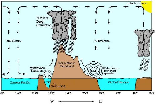
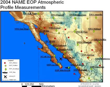
Schematic illustrating the multi-tiered approach of the North American Monsoon Experiment (NAME). The schematic also shows mean (July-September 1979-1995) 925-hPa vector wind and merged satellite estimates and raingauge observations of precipitation (shading) in millimeters. Circulation data are taken from the NCEP/ NCAR Reanalysis archive.
NAME Science Working Group (as of September 2003):
Jorge Amador, UCR Hugo Berbery, UMD
Miguel Cortéz, SMN/Mexico Art Douglas, Creighton University Michael Douglas, NSSL/NOAA
Dave Gochis, NCAR/RAP Wayne Higgins, CPC/NOAA Richard Johnson, CSU Dennis Lettenmaier, UWash Rene Lobato, IMTA/Mexico Robert Maddox, UAZ Kingtse Mo, CPC/NOAA Francisco Ocampo, CICESE Erik Pytlak, NWS Tucson WFO Andrea Ray, CDC/NOAA Jae Schemm, CPC/NOAA Siegfried Schubert, NASA/GSFC David Stensrud, NSSL/NOAA Chidong Zhang, RSMAS
Table of Contents
Page
Preface 4
Summary 5
Part 1: NAME AND ITS SCIENTIFIC OBJECTIVES 6
1.1 Rationale 6 1.2 Objectives 7 1.3 Anticipated Benefits and Milestones 10 1.4 Endorsements 10 1.5 NOAA ISIP and CPPA Programs 11 1.6 GAPP and NAME 11 1.7 Other Linkages 11 Part 2: SCIENTIFIC BASIS FOR NAME 12
2.1 North American Warm Season Precipitation Regime 12
2.2 Role of Oceanic Forcing of Continental Climate Anomalies 13
2.3 Role of Land Surface-Atmosphere Interactions 14
2.4 Role of Low-Level Jets 15
2.5 Links to Applications, Assessment, and Human Dimensions Research 17
Part 3: THE NAME PROGRAM 18
3.1 Nature of the Research 18
3.2 Multi-Scale Framework 19
3.2.1 Core Monsoon Region 20
3.2.2 Regional-Scale 23
3.2.3 Continental-Scale 26
3.3 NAME Modeling and Data Assimilation 29
3.4 Timeline 37
3.5 Project Structure 38
Part 4: NAME 2004 ENHANCED OBSERVATION PERIOD 41
4.1 Background 41
4.2 Status 41
4.3 Region of Focus 42
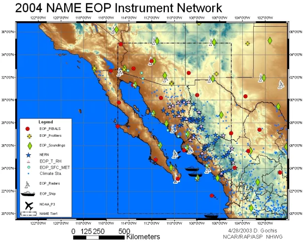
4.4 Instrument Platforms 42
4.4.1 Surface Meteorology 44
4.4.2 Radar 48
4.4.3 Atmospheric Soundings and Profiling 51
4.4.4 Aircraft 56
4.4.5 Oceanographic 56
4.5 IOP Protocols 57
Table of Contents
(cont.) Page4.7 Forecast Operations Center 61
4.8 Field Operations and Procedures 64 4.9 The NAME Field Catalog 65 4.10 NAME Data Management and Policy 65 4.11 International Partnerships 65 4.12 NAME "Teachers in the Field" 69 4.13 NAME K-12 Education Component 69 APPENDIX A: THE NORTH AMERICAN MONSOON SYSTEM 70
A.1 Life Cycle 70
A.2 Continental-Scale Precipitation Pattern 72
A.3 Interannual Variability 75
A.4 Decadal Variability 77
A.5 Intraseasonal Variability 78
References 83
Preface
Previous research has demonstrated potential for the prediction of warm season
precipitation over North America. Recent advances in the monitoring and modeling of ENSO-precipitation relationships and in the diagnosis and understanding of the role of coupled ocean-atmosphere-land surface interactions in the continental hydrologic cycle have promoted the idea that there is a deterministic element in the year-to-year variability of precipitation, particularly during the cold season. To date, however, the climate community has not been very successful in extending our understanding of these broad precipitation relationships to improved operational prediction of warm season precipitation - this despite new research that has demonstrated
potential predictability of warm season precipitation over North America. This is due in part to constraints imposed by our observational database, which is limited in spatial extent and
temporal resolution, and which is often not available in real time for use as initial and boundary conditions in climate prediction. These problems are of particular concern over Latin America, where observations are more limited than over the United States.
In this document we develop these concepts more fully, in particular by outlining the science issues associated with gaps in our understanding of the North American Monsoon System (NAMS). Plans for field work that would target those gaps, and result in the improved understanding necessary to advance warm season precipitation prediction are presented. The document emphasizes the interactive combination of ocean-forced atmospheric circulation anomalies and land-atmosphere feedbacks that make climate diagnostics and prediction
especially challenging in the NAMS domain. A multi-scale (tiered) approach to the field work is proposed, in which each tier has a specific research focus aimed at determining the sources and limits of warm season precipitation predictability on seasonal-to-interannual timescales. These efforts will benefit from strong links with several CLIVAR-led and GEWEX-led programs whose observations will place these process studies in a broader spatial and temporal context.
This document was compiled by the NAME Science Working Group (SWG), whose members are listed on page 1. This version includes recent progress on the NAME 2004
Summary
The North American Monsoon Experiment (NAME) is an internationally coordinated, joint CLIVAR-GEWEX process study aimed at determining the sources and limits of
predictability of warm season precipitation over North America, with emphasis on time scales ranging from seasonal-to-interannual. It focuses on observing and understanding the key components of the North American monsoon system and their variability within the context of the evolving land surface-atmosphere-ocean annual cycle. It seeks improved understanding of the key physical processes that must be parameterized for improved simulation with dynamical models. NAME employs a multi-scale (tiered) approach with focused monitoring, diagnostic and modeling activities in the core monsoon region, on the regional-scale and on the continental-scale. NAME is part of the CLIVAR/VAMOS program, US CLIVAR Pan American research, and the GEWEX America Prediction Project (GAPP).
The scientific objectives of NAME are to promote a better understanding and more realistic simulation of:
• warm season convective processes in complex terrain (Tier 1); • intraseasonal variability of the monsoon (Tier 2);
• the response of the warm season atmospheric circulation and precipitation patterns to
slowly varying, potentially predictable oceanic and continental surface boundary conditions (Tier 3);
• the evolution of the North American monsoon system and its variability.
To accomplish these objectives, planning has proceeded with the intent of developing:
• empirical and modeling studies plus data set development and enhanced monitoring
activities that carry on some elements of the existing PACS program and the US CLIVAR/GEWEX Warm Season Precipitation Initiative (2000-2004);
• the NAME 2004 field campaign, including build-up, field, analysis and modeling phases; • empirical and modeling studies in the joint NOAA CPPA program (2004+).
In addition to significant improvements in short-term climate prediction, NAME will lead to joint international experience with Mexican and Central American scientists in the
exploitation of in situ and satellite data, advancements in high-resolution climate models, advancements in the development of the climate observing system, and the production of consistent climate data sets over the Americas.
1. NAME AND ITS SCIENTIFIC OBJECTIVES
1.1 Rationale
State-of-the-art climate models do not accurately represent the spatial distribution and temporal variability of warm season precipitation over North America. There are many
processes and feedbacks operating within the atmosphere, at the surface, and below the surface that are not represented in the models. These deficiencies are the motivation for the North American Monsoon Experiment (NAME), an internationally coordinated effort to determine the sources and limits of predictability of warm season precipitation over North America, with emphasis on time scales ranging from seasonal-to-interannual. This goal is motivated by recent advances in our understanding of ENSO-precipitation relationships and of the role of the land surface memory component in the continental hydrologic cycle which, when viewed collectively, suggest a deterministic element in the year-to-year variability of summertime precipitation over North America.
A fundamental and necessary first step towards improving warm season precipitation prediction is the clear documentation of the major elements of the warm season precipitation regime and their variability within the context of the evolving land surface-atmosphere-ocean annual cycle. Monsoon circulation systems, which develop over low-latitude continental regions in response to seasonal changes in the thermal contrast between the continent and adjacent oceanic regions, are a major component of continental warm season precipitation regimes. The North American warm season is characterized by such a monsoon system [hereafter referred to as the North American Monsoon System or NAMS]. The NAMS provides a useful framework for describing and diagnosing warm-season climate controls and the nature and causes of year-to-year variability. A number of studies during the past decade have revealed many of the major elements of the NAMS, including its context within the annual cycle and some aspects of its variability. Its broadscale features and variability are described together with a literature review in Appendix A.
NAME will exploit available and enhanced observations and synthesize these into a complete depiction of the NAMS. A range of models will be used to assess our capability to simulate the evolution of the warm season precipitation regime, its variability and feedbacks. These studies will enhance our physical understanding and identify deficiencies in our
observational and modeling capabilities. While there has been considerable progress in recent years, clearly we do not yet have the capability to produce accurate precipitation forecasts during the warm season (particularly on intraseasonal-to-seasonal time scales). This leads to a number of general questions that must be addressed in order to move forward:
• How is the evolution of the warm season (May-October) atmospheric circulation and
precipitation regimes over North America related to the seasonal evolution of oceanic and continental boundary conditions?
boundary conditions, the atmospheric circulation and the warm season precipitation patterns?
• What are the significant features of and interrelationships between the
anomaly-sustaining atmospheric circulation and the boundary conditions that characterize large-scale long-lasting continental precipitation (and temperature) anomaly regimes?
• What are the dynamical linkages between the NAMS domain and the larger-scale
climate system across North America and nearby oceans on seasonal-to-interannual time scales?
In each of these questions the term “boundary conditions” refers to both the land surface and the oceans. Thus, a question that encompasses each of the above questions is:
• What are the relative roles of remote boundary forcing (particularly tropical Pacific
SST), local and regional sea and land surface forcing (e.g. Gulf of California SST and soil moisture) and internal atmospheric dynamics in the seasonal-to-interannual variability of warm season precipitation over North America?
In light of such critical questions, the time has come to introduce a comprehensive program that measures the suite of coupled atmospheric, land surface and oceanic parameters that collectively characterize the warm season precipitation regime and its variability. There are several additional factors indicating that this is an appropriate time for NAME: (1) Several global operational centers (e.g. NCEP and ECMWF) are able to provide consistent large-scale forcing as well as local analyses to support such an effort; (2) the NCEP Regional Reanalysis project and the Land Data Assimilation System (LDAS) products are available; and (3) there is a synergy with several other programs, ongoing and planned, including VAMOS/MESA, PACS, GAPP and CEOP.
1.2 Objectives
It is clear that we do not have the basic understanding of the NAMS required for skillful seasonal-to-interannual predictions of warm season precipitation. NAME is planned to address this lack of understanding. The scientific objectives of NAME are to promote a better
understanding and more realistic simulation of:
• warm season convective processes in complex terrain (Tier 1); • intraseasonal variability of the monsoon (Tier 2);
• the response of the warm season atmospheric circulation and precipitation patterns to
slowly varying, potentially predictable oceanic and continental surface boundary conditions (Tier 3);
In addition to these scientific objectives, NAME researchers will interact with applications, assessment, and human dimensions researchers on the potential use of NAME science by end users.
Achieving these objectives will require improved empirical and modeling studies of the monsoon system and its variability, sustained observations of the atmosphere, ocean and land and enhanced observations over portions of the core monsoon region, combination of the
observations and numerical models through data assimilation, and high-resolution coupled model runs with various combinations of the relevant boundary forcing parameters.
An implementation plan is presented here that includes high intensity process studies to be concentrated within one month, investigations of processes that span the monsoon season or an annual cycle (~4 to 18 months), and monitoring to be sustained for two (or more) years. Specific activities for an enhanced observing period during the summer of 2004 is presented to illustrate that the scientific objectives of NAME can be met. NAME process studies will constitute a multi-scale approach in space and time (Fig. 1). The enhanced observations during the summer of 2004 are focused in the core monsoon region and on the regional-scale, and to a lesser extent on the continental-scale.
1.3 Anticipated Benefits and Milestones
The NAME Program will deliver the following:
• Observing system design for monitoring and predicting the North American monsoon system;
• More comprehensive understanding of North American summer climate variability and predictability;
• Strengthened multinational scientific collaboration across Pan America;
• Measurably improved climate models that predict North American monsoon variability months to seasons in advance.
Some milestones that will be used to track progress in operational summer prediction include:
• Benchmark and assess current global and regional model simulations of the North
American monsoon (2004);
• Evaluate the impact of additional data from the NAME 2004 field campaign
on operational analyses and forecasts (2006);
• Simulate the initiation of regular deep convection (i.e. monsoon onset) to within a week
of its observed initiation (2006);
• Simulate the diurnal cycle of observed precipitation to within 20% on a monthly
averaged basis (2007);
• Reproduce the magnitude of the observed afternoon peak of latent and sensible heat
fluxes to within 20% on a monthly averaged basis (2008)
1.4 Endorsements
NAME is the North American implementation of the WCRP CLIVAR/VAMOS program (the South American implementation is Monsoon Experiment South America or MESA).
1.5 NOAA ISIP and CPPA Programs
Recently the NOAA PACS and GAPP programs merged to form the Climate Prediction Program for the Americas (CPPA). CPPA is the research component of the new NOAA
Intraseasonal-to-Interannual Prediction (ISIP) program. NAME objectives are closely linked with those of CPPA and hence NAME is the first field campaign to be supported by CPPA. The CPPA interest in NAME is to improve intraseasonal to interannual climate forecasts for the warm season. CPPA will continue to support warm season precipitation diagnostic and
modeling studies through NAME after 2004. More information about these programs is found in a Powerpoint presentation on the NAME WWW page at the URL:
http://www.joss.ucar.edu/name/science_planning/SWG5/BROWSE/Session1/Huang2.htm
1.6 GAPP and NAME
The North American Monsoon Experiment (NAME) provides one of the principal operational foci for the implementation of the GEWEX Americas Prediction Project (GAPP) research on warm season precipitation. NAME has a major emphasis on the role of the land surface and the role of the Great Plains and Gulf of California low-level jets. NAME integrates GAPP interests with studies of the role of oceanic forcing of continental climate anomalies, since ocean memory components evolve slowly and are to some degree predictable in their own right, and warm season correlations between SST and continental precipitation are at least marginal. Specific aspects of NAME’s contribution to GAPP are discussed in the GAPP Science and Implementation Plan.
NAME research on warm season precipitation will contribute to the North American component of the Coordinated Enhanced Observing Period (CEOP). CEOP and NAME are coherent in terms of timing (2004 is the CEOP second annual cycle period). A key issue for CEOP is an international commitment and cooperation on data collection and exchange. NAME has very strong international collaboration between the US and Mexico, and between both GEWEX and CLIVAR. Other anticipated benefits of a strong NAME-CEOP linkage include joint international experience in the exploitation of new in situ and satellite data; the production of consistent data sets that can act as test beds for the validation of numerical model products and remote sensing data; advancements in coupled model development over land and ocean areas; and advancements in the development of the climate observing system.
1.7 Other Linkages
In addition to linkages discussed in sections 1.4-1.6, NAME will maintain strong ties to:
• Other monsoon-related projects, such as the international CLIVAR VAMOS Monsoon
the Asian monsoon systems. These ties will be facilitated greatly through joint research efforts supported by the CPPA program;
• The U.S. and International CLIVAR programs, which are conducting considerable warm
season precipitation research over the oceans (e.g. EPIC, VOCALS), complementing GAPP's emphasis on continental precipitation;
• NASA's Global Precipitation Monitoring Project to strengthen long-term precipitation
monitoring activities;
• The NOAA RISA programs, which will help NAME ascertain promising targets for
enhanced precipitation monitoring, prediction, and information dissemination;
• NRCS and USGS, for more extensive land surface data sets; and
• The DOE ARM program for high-quality data on cloud and radiation variability that
would enhance NAME research on warm season precipitation.
2. SCIENTIFIC BASIS FOR NAME
2.1 North American Warm Season Precipitation Regime
Over southwestern North America there is a continental-scale monsoon-like circulation regime that is associated with the summertime precipitation climatology of the region. While some aspects of the seasonally varying climate over the southwest U.S., Mexico and Central America have been well described (see Appendix A for a literature review), others have not. Large-scale patterns of drought and streamflow anomalies have been empirically linked to potentially predictable Pacific SST anomalies on interannual to decadal time scales. Links between the summer monsoon in southwestern North America and summertime precipitation in the Great Plains of the United States may have predictive value at the seasonal time scale.
The structure of the low-level circulations that supply moisture from the tropics along the Gulf of California and from the Gulf of Mexico, the precipitation patterns and associated
divergent circulations, and the moisture and energy budgets over the core North American monsoon region remain largely unvalidated and incompletely understood. Dynamical understanding of the seasonal march of rainfall and its variability over Mexico and Central America is incomplete. The meteorological observation and analysis system for this region must be improved to describe and understand relationships among low-frequency anomalies of the warm season precipitation regime and the nature and frequency of significant weather events such as hurricanes and floods.
number and / or intensity of these events over a month or season can vary substantially from year to year. Part of this time-averaged variability appears to be a response to subtle variations in the distribution of tropical SSTs, but the mid-latitude response to tropical ocean anomalies is
regionally and seasonally dependent. Large seasonal-to-interannual variations in the advective moisture supply from the oceans to the North American continent help to govern the warm season precipitation regime.
There is also persuasive evidence that potentially predictable anomalies of soil moisture, snow cover and vegetation may play an important role in the seasonal variability of North American warm season precipitation patterns. Because these land surface anomalies are themselves largely determined by fluctuations of precipitation, it has been suggested that there are important feedbacks between the atmosphere and land surface that can be either positive (in which case climate anomalies are self-sustaining) or negative (self-suppressing). Diagnosis of these feedback pathways will require significant advances in the quality of observations and modeling of the NAMS domain.
2.2 Role of Oceanic Forcing of Continental Climate Anomalies
The land and ocean surface memory components of the climate system evolve more slowly than the individual precipitation-producing circulation systems and are to some degree predictable in their own right (see Appendix A). Prospects for improved prediction on seasonal-to-interannual time scales hinge on the inherent predictability of the system, and our ability to quantify the initial states and forecast the evolution of the surface forcing variables (i.e. SST, vegetation and soil moisture).
The influence of tropical SST anomalies on North American climate is statistically most obvious during the cold season, but warm season correlations between SST and continental-scale precipitation are at least marginal. The climate system exhibits some simplicity in the form of a few phenomena that are the building blocks to progress in climate forecasting. The El Niño/ Southern Oscillation (ENSO) phenomenon is the major source and best understood of these. Climate research has identified several additional oceanic and atmospheric phenomena that establish global climate patterns, including the Pacific Decadal Oscillation (PDO), and the Madden-Julian Oscillation (MJO). The PDO, like ENSO, can cause systematic changes in the large-scale circulation patterns that lead to regional changes in the number and intensity of storms. The MJO, when it is active, dramatically increases the intraseasonal variability in the tropics and subtropics. The relative influences of these modes of variability on the warm season precipitation regime over North America are not well understood.
important changes in the winter correlation patterns between U.S. rainfall and ENSO. Much of our empirical knowledge of ENSO rainfall effects over the U.S. have been obtained during the recent period of North Atlantic cooling (roughly 1969-1994). However, very little is known about how this low-frequency SST variability interacts with the interannual fluctuations of the North American Monsoon.
The role of the Intra-Americas Sea (IAS) region (from roughly 55°W to the Americas, and roughly 5°N to 30°N, i.e., the Caribbean Sea, Gulf of Mexico, Straits of Florida, and adjacent waters of the North Atlantic) in modulating warm season precipitation prediction over North America is uncertain. Of interest to NAME is the possibility for strong interactions between the IAS, the eastern Pacific warm pool region and southwestern North America. In addition, improved warm season precipitation prediction over the U.S. Great Plains may be contingent on a better understanding of the hydrologic cycle of the IAS region. Though the hydrologic cycle of the IAS has not received much attention to date, some of its oceanic and atmospheric components are beginning to come into focus.
2.3 Role of Land Surface-Atmosphere Interactions
The relative importance of the land and ocean influences on North American
precipitation changes with the seasons. The influence of the land surface is strongest during the warm season, when the continents are warmer than the surrounding oceans and surface
evaporation is large and varies greatly as a function of terrain and vegetative cover. It should be noted that the influence of SST anomalies on cold season precipitation can indirectly affect warm season rainfall, since they play a role in determining the initial springtime soil moisture
conditions and vegetative cover, which in turn can feed back upon the climate during the warm months through their influence on surface air temperature and evaporation.
The land surface has many memory mechanisms beyond soil moisture, especially over the western US. Snow extends surface moisture memory across winter and spring. Vegetation in semi-arid regions is a seasonally evolving, interannually variable atmospheric boundary condition that affects momentum transfer, radiation, heat and moisture fluxes.
It is important to recognize that, depending on the variable and the time of the year, the evolution of particular surface forcing variables may not be slow. For example, in western Mexico the vegetation type and fractional vegetation coverage changes dramatically in just a few weeks during the onset of the summer monsoon. Observations from the Oklahoma Mesonet indicate that soil moisture can change dramatically with one heavy rainfall event.
As indicated above, the surface hydrology of western North America plays a fundamental but inadequately understood role in the warm season precipitation regime. The complex terrain and semi-arid conditions of this region stand in stark contrast to the Mississippi Valley which was the focus of the GEWEX Continental-scale International Project (GCIP). For example, in Southwest North America lush natural vegetation exists primarily in narrow strips along the banks of rivers in the middle of arid deserts. A proper characterization of large-scale
evapotranspiration must somehow resolve these one-dimensional ribbons of vegetation, which can be much narrower than the typical footprint of an AVHRR-based vegetation scene.
Consideration of such questions will make the surface hydrological component of NAME dramatically different than was the case for GCIP, making NAME an excellent complement to GCIP and focus for GAPP.
Soil moisture also varies much differently in the arid NAMS domain compared with the more mesic GCIP region. Soil type and vegetation cover depend strongly on the surface elevation and slope aspect, both of which are tremendously variable over short distances in regions of complex terrain. Runoff is highly channelized. The short duration of most warm season precipitation episodes, combined with intense solar radiation, make for intense but short-lived episodes of surface evaporation following rainstorms. For all of these reasons, the surface hydrology component of NAME will provide a severe test of land surface models and will facilitate the continued progress on these models accomplished in GCIP. More complete and detailed analysis of surface hydrology and soil moisture will be a fundamental component of NAME research.
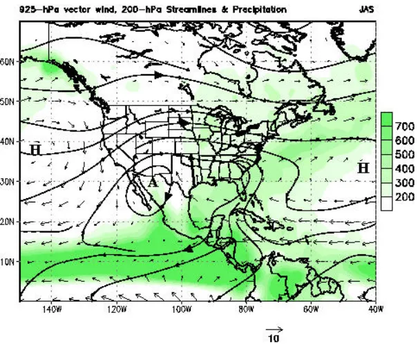
2.4 Role of Low-Level Jets
The Great Plains low-level jet (GPLLJ) plays a critical role in the summer precipitation and hydrology of the central US while the Gulf of California low-level jet (GCLLJ) contributes to the summer precipitation and hydrology in the southwestern U.S. and Mexico (Fig. 2). Developing a better understanding of both of these jets is of critical importance to NAME.
understood and modeled. For example, nocturnal dynamic and thermodynamic factors may be mutually reinforcing, thus contributing to the strength of the moisture convergence into the Mississippi River Basin during the night and early morning.
The GCLLJ is inextricably linked to Tropical Easterly Waves (TEWs) and Gulf of California moisture surge events that play a critical role in the intraseasonal variability of the monsoon along the west coast of Mexico and in the southwest U.S. Most of the moisture in the lower troposphere (below 850-hPa) over the southwestern U.S. (west of the continental divide) arrives with the GCLLJ, while most of the moisture at higher levels arrives from over the Gulf of Mexico. Difficulties in explaining the observed precipitation distribution and its timing, have been due, in part, to the fact that Baja California and the Gulf of California have not been properly resolved in models and reanalyses in the past.
2.5 Links to Applications, Assessment, and Human Dimensions Research
There is an active community of researchers in the NAME region who are undertaking studies on the applications of climate and weather information in the American Southwest, on the sensitivity and vulnerability of people in the region to climate variability, and on the
usability of forecasts in the region. An assessment of the impacts, information needs, and issues for policymaking has been made for the U.S. However, the North American Monsoon crosses national boundaries, so any effort to understand its impacts and interactions with society must extend beyond the U.S. southwest. Several institutions focus on these issues in the multinational monsoon region, including the Climate Assessment Project for the Southwest (CLIMAS), based at the University of Arizona, the Western Regional Climate Center, and the international
Cooperative Research Networks (CRN) funded by the InterAmericas Institute (IAI).
There is an opportunity for NAME to link to this community and interact to improve the potential of NAME research to address societal needs. This interaction between NAME and applications, assessment, and human dimensions research can contribute to improvements in the flow of climate information from producers to users, and produce experimental products and information specific to identified needs of users in the region.
These research and applications efforts have identified a number of sectors and user groups for whom information is important on summer precipitation and temperature, and the monsoon in particular. These include reservoir managers, fire managers, dryland farmers, ranchers, small agricultural producers, and urban water users. Water scarcity related to climate variability is also important to the rural poor of the region. Surveys conducted with stakeholders in the region provide valuable information about the needs of certain users for information, and including specific lead times, and variations in information needs across the year.
researchers and applications researchers can contribute to development of climate services for the region, building on NAME research.
Several institutions in the region have a focus on regional studies related to climate variability, and are involved in routine or pilot activities to disseminate climate information to users and evaluate its influence and usability. Since inception in February 1998, CLIMAS has focused on integrating regionally relevant climate and hydrologic research with analysis of stakeholder sensitivities and vulnerabilities to climate and its impacts. CLIMAS has begun to develop a formal mechanism to provide climate services specifically tailored for users in the desert Southwest. Three other institutions have experience with applications studies in the monsoon region: the Desert Research Institute has a long history of arid lands studies; the Western Regional Climate Center has extensive experience with user services; and the NOAA Climate Diagnostics Center has been interacting with users via climate briefings to targeted user communities. In addition, the NOAA Office of Global Programs Economics and Human
Dimensions Program has funded a number of studies in the region. In the multinational context of the monsoon, the IAI has funded several collaborative research projects in Mexico and Central America focusing on the impacts of climate variability on disaster risks in the region. These projects, as well as others of the IAI and the International Research Institute for Climate Prediction, could provide opportunities for international collaboration on applications of monsoon information.
3.0 THE NAME PROGRAM
A brief discussion of the general nature of NAME research is followed by a more in depth discussion of NAME research questions and activities.
3.1 Nature of the Research
The NAME objectives will be addressed by a symbiotic mix of diagnostic, modeling and prediction studies together with enhanced observations. This research activity will necessarily be diverse because it seeks to answer scientific questions relating to several different coupled processes and phenomena. However, there is a substantial similarity in the methods that will be used to achieve these objectives.
As part of its overall effort, the NAME will contribute to the development of improved land surface and hydrologic models as well as improved land-atmosphere coupled models. Ultimately, there is a need to evaluate the ability of coupled models to describe and predict climate and hydrologic variables at regional scales. In general, such tests will require multi-member ensemble experiments with high resolution, coupled models using well-specified
observations of atmospheric forcing as model boundary conditions. In regions where the surface forcing of the atmosphere varies on spatial scales of less than a few hundred kilometers, the current resolution of GCMs is inadequate to resolve the detailed variability required for application to water resource problems on the catchment scale. On the other hand, higher resolution regional mesoscale models (RMMs) cannot reflect the full planetary forcing, but can more accurately represent the effects of regional gradients associated with features such as coastlines, orography, land use, soil and vegetation type.
In some cases NAME studies will be “event oriented”, i.e. studies “indexed” to the life cycles of specific events. As a consequence, the spatial domain of these studies will necessarily range from mesoscale to continental-scale. Some studies will require a full latitude perspective over the North American sector, from the ITCZ to at least the middle latitude storm track. These studies will be carried out in tandem with land surface model experiments and land data
assimilation experiments, and will benefit from multi-year regional reanalyses and retrospective soil moisture analyses.
NAME will develop a variety of basic data sets and data products, which will be distributed primarily from the established data distribution centers (e.g.UCAR/JOSS, NCDC, CDC) and via the data management activities of US CLIVAR Pan American research,
CLIVAR/VAMOS and GAPP. Where augmentation is required, it will be accomplished by an expansion of the data management activities of these programs.
3.2 Multi-Scale Framework
A multi-scale (tiered) approach to the analysis, diagnostic and model development activities of NAME is recommended (Fig. 1). NAME will include focused activities in the core monsoon region, on the regional-scale and on the continental-scale, which for convenience are referred to as Tier 1, Tier 2, and Tier 3 respectively. Each tier has a specific research focus aimed at improving warm season precipitation prediction, and activities related to each tier will proceed concurrently. The core monsoon region will include reference networks (e.g. wind profiler / radar and raingauge networks), which are well instrumented regions of small to
In the following, focused research questions for each tier are stated and used to illustrate the nature of the research activity that will be undertaken.
3.2.1 Core Monsoon Region
A primary objective of Tier 1 activities is to resolve the wind, temperature, and moisture fields at fine spatial and temporal scales around the Gulf of California, sufficient to develop stable monthly means during the summer. There is also an emphasis on the synoptic-scale (and regional scale) signal associated with Gulf of California surge events. The principal scientific questions are:
• How are low-level circulations along the Gulf of California / west slopes of the
Sierra Madre Occidental related to the diurnal cycle of moisture and convection?
• What is the relationship between moisture transport and rainfall variability
(e.g. forcing of surge events; onset of monsoon details)?
• What is the typical life cycle of diurnal convective rainfall? Where along the
western slope of the Sierra Madre Occidental is convective development preferred?
• What are the dominant sources of precipitable moisture for monsoon precipitation
over southwestern North America?
• What are the fluxes of energy and water from the land surface to the atmosphere
across the core monsoon region, and how do these fluxes evolve in time during the warm season?
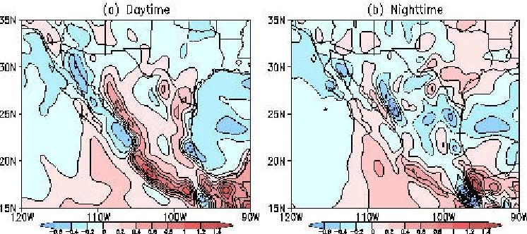
None of the earlier field campaigns in southwestern North America (e.g. SWAMP 90, EMVER 93) have emphasized the large-scale coupling of the low-level circulations along the Gulf of California to those along the western slopes of the SMO. To anyone who has monitored this region on a daily basis during the warm season, it is clear that this coupling is intimately related to the diurnal cycle of moisture and convection along the western slopes of the SMO and along the Gulf of California. Because the amplitude of the diurnal cycle is regime dependent, it is important to understand the nature of the relationship between the diurnal cycle and the
seasonally varying atmospheric circulation and precipitation patterns. The core monsoon region is uniquely suited for studies of the role of the diurnal cycle because it is a region where the amplitude of the diurnal cycle far exceeds the amplitude of the annual cycle.
North America during the warm season (e.g. the southeastern United States). Although indirect estimates of many of the low-level circulation features are provided by satellite remote sensing techniques (e.g. cloud-track winds and the diurnal cycle of cloud cover), these analyses have deficiencies and require calibration. Better documentation of the horizontal and vertical structure of these circulation features and their relationships to convection is critical.
Diagnostic and modeling studies are required to describe and understand the structure of the low-level circulations that supply moisture from the tropics along the Gulf of California, the precipitation patterns and associated divergent circulations, and the moisture and energy budgets over the core North American monsoon region. Available in situ and satellite remote sensing data can be used to help guide these analyses. However, improved data are needed to describe the moisture fluxes over the region with sufficient spatial and vertical resolution to clearly distinguish between different models (meso-Eta, MM5, NCEP reanalyses, etc). This needs to be done over a larger portion of the Gulf of California than has been done in previous field
campaigns. There are also large differences between reanalysis moisture fluxes and observed (radiosonde-based) fluxes in the 1000-850 hPa layer in the core monsoon region. For example, the reanalyses would suggest that moisture influx from the tropical pacific is very important in the rains over NW Mexico while observations suggest that this influx is less important.
The meteorological observation and analysis system for the core monsoon region must be enhanced in order to resolve the low-level circulations, the diurnal cycle and the coupling with the earth’s surface. Regional mesoscale models and assimilation systems (such as the Eta Model Data Assimilation System (EDAS)) can be used to guide enhanced monitoring activities.
Enhancements to the radiosonde and pilot balloon networks over Mexico, the wind profiler / radar network in the core monsoon region, transects of recording raingauges from the Gulf of California to the SMO, automatic meteorological stations (wind, surface air temperature, dewpoint, sea-level pressure, and precipitation), instrumentation (e.g. radiometers) to calculate surface energy budgets and fluxes, and research aircraft operations are recommended during the NAME field campaign (see Part 4 for a scientific justification and details).
High resolution models and analyses are required to examine the separation between water vapor east of the continental divide, which clearly originates from the Gulf of Mexico / Caribbean Sea, and moisture over the Sonoran Desert that appears to originate from the Gulf of California. Additional studies using high-resolution mesoscale models and analyses are needed to describe and understand linkages between the sea breeze / land breeze phenomenon and the intense afternoon and evening precipitation along the west slopes of the SMO and the morning precipitation near the coastline and over the Gulf of California. Modeling studies of the diurnal cycle of convection are also required, in particular, to determine the effects of model resolution and changes in physical parameterizations on precipitation in the core monsoon region.
April 1995 from the NCEP Eta model. Currently, there are ~1200 Eta MOLTS, each of which includes an extensive array of upper air and surface parameters (many of which are not available on the regular Eta grid). Within the framework of the GEWEX Combined Enhanced Observing Period (CEOP), NAME has proposed a few additional MOLTS sites to coincide with the upper air sounding sites in the NAME domain over Mexico and in the Intra-Americas Sea region. We note that many of the upper air sounding sites within the NAME domain are already MOLTS sites, but there are ~25 sites that are not (including the proposed PIBAL sites and the PACS Sonet sites). These data will be used for model validation studies, and for closing regional water budgets (i.e., over the Intra-Americas Sea, Gulf of Mexico or Mexico).
Observations strongly suggest that mean moisture fluxes over the northern Gulf of California (e.g. Puerto Penasco) are larger than over the Central Gulf, near Empalme. This feature is not resolved by current analyses. While it is a relatively small-scale feature in terms of climate considerations, nevertheless it would be a good test of the quality of a data assimilation scheme to reproduce it. It is unclear, however, whether these transports are due to higher winds at Puerto Penasco or a deeper moist layer (which the CEDO radiosonde data from EMVER and other field observations do not suggest). Enhancements to the in situ sounding network around the northern Gulf of California region are needed to answer this question.
An important goal of the NAME field phase is to gather sufficient observations to determine the importance of vegetation-atmosphere feedbacks in moving the precipitation maximum towards the Gulf of California throughout the summer. The pattern of monsoon precipitation evolves from the high peaks of the SMO (June) to the foothills (July) and finally to the coastal areas and southern Baja California (August and September). It is unclear whether this is a response to land-sea thermal contrast (the land cools from June to Sept while the ocean warms) or a response to changes in vegetation. Micro-meteorological measurements and accurate measurements of the land-sea diurnal circulations will be needed to address these question.
Diagnostic studies and coupled model runs, with various combinations of the relevant boundary forcing parameters, are required to determine the relative contributions of Gulf of California SSTs, soil moisture and vegetation to warm season precipitation variability in the core monsoon region. Studies with stand alone hydrological models, using observed and model-calculated forcing, are also required to investigate the influence of topography-dependent precipitation on the hydrological response of watersheds. Multi-member ensemble experiments with high-resolution regional coupled models are also needed for areas with marked topography to calculate topography-dependent precipitation probability distribution functions (PDFs) for validation against observed PDFs.
state evolves throughout the monsoon season. NAME recommends that these towers be co-located with radiosonde stations as part of the enhanced radiosonde network. The surface flux data obtained from the towers would provide important ground truth for more spatially extensive satellite estimates. This is an important step in understanding the coupled land-atmosphere system.
Much of the NAMS domain is characterized by a heterogeneous, highly variable terrain and vegetation. For example, there are many densely vegetated ribbons along rivers (~1 km wide in some places) that may account for a substantial fraction of the evapotranspiration of the region. Characterizing the surface fluxes here is challenging, but critical for understanding and simulating the hydrologic cycle in southwestern North America.
Considering the sparse observing network and the high spatial variability of the land surface across the NAMS domain, the only feasible way to derive comprehensive estimates of land surface characteristics is via satellite estimates. An important goal for NAME will be to motivate improvements in satellite-based characterization of soils and vegetation and associated estimates of sensible and latent heat fluxes. Many operational satellite data products are limited in spatial resolution, a critical problem for NAME. New satellite instruments, such as ASTER on EOS-AM1, promise spatial resolution of 10s of meters. Such resolution will be important for characterization of important hydrological parameters in areas of sharp gradients, e.g. river valleys and mountainous regions.
3.2.2 Regional-Scale
Tier 2 focuses on regional-scale features over southwestern North America and the warm pool region to the southwest of Mexico. The goal of activities in this region is an improved description and understanding of the major factors contributing to intraseasonal variability of the monsoon. The principal scientific questions are:
• How important are interactions between Tropical Easterly Waves and Gulf of
California moisture surges in the prediction of monsoon precipitation?
• What is the nature of the relationship between the MJO, tropical cyclone activity and
monsoon precipitation?
• What portion of the skill of summer precipitation forecasts, in addition to that already
harvested from ENSO, will arise from an ability to forecast MJO activity over a season?
• What is the physical setting for the bimodal distribution (i.e. wet-dry-wet) in warm
It is possible to identify many phenomenological factors that produce variability within a monsoon season on time scales of a few days to a few weeks (e.g. synoptic-scale disturbances, monsoon troughs, mid-latitude effects and quasi-periodic oscillations). NAME will focus on Tropical Easterly Waves (TEWs), Gulf of California moisture surges and their interactions, since these disturbances appear to have a significant influence on monsoon rainfall over a season. A primary focus for NAME will be on the extent to which these influences are predictable.
The role of the MJO in modulating the monsoon, as well as linkages between the MJO, tropical cyclones and monsoon precipitation will be investigated. NAME will also examine the physical mechanisms contributing to interannual variability in active (break) monsoons and the pronounced double peak structure in precipitation over Mexico and Central America.
An important goal of the NAME field phase is to gather sufficient data to determine the importance of gulf surges in transporting moisture up the Gulf. In particular, do they really enhance rainfall in the mean, or do they just rearrange the distribution of rainfall? What larger-scale circulations generate the surges, and through what processes? How are these relevant to climate-scale issues? In addition, diagnostic studies are needed to examine the structure of the TEWs and Gulf of California surge events, their frequency of occurrence, their linkages, and the temporal evolution of the associated moisture transport. Other important issues include the fraction of TEWs that produce Gulf surges, the physical mechanisms responsible for this linkage, and the role of boundary forcing.
Another aspect of the linkages between TEWs and Gulf of California moisture surges that has not been explored systematically is the extent to which they might influence the interannual variability (i.e. onset and intensity) of the monsoon, especially over northwestern Mexico and the southwestern U.S. High resolution mesoscale models and coupled ocean-atmosphere-land models that accurately simulate these disturbances are also needed. In order to be useful, the models must reproduce the common weather characterisitics of these disturbances (e.g. in the case of the moisture surge events this includes a rise in dewpoint temperature, a decrease in the diurnal temperature range, a windshift with an increased southerly wind component, and increased cloudiness and precipitation) which can be validated against in situ and satellite remote sensing data.
The intraseasonal variability of monsoon precipitation over North and Central America is also related to the eastward progression of intraseasonal oscillations (such as the MJO) around the global tropics. Of tremendous practical significance is the fact that there is a coherent relationship between the phase of the MJO and the points of origin of tropical cyclones in the western Pacific, eastern Pacific and Atlantic basins, suggesting that the MJO modulates this activity. The precise nature of this relationship remains elusive. NAME studies will address the following questions:
• How does the phase of the MJO relate to the frequency and intensity of hurricanes
• What fraction of the summer rainfall over the Americas is due to tropical storms and
hurricanes?
• Does interannual-to-interdecadal variability of the MJO contribute to tropical
cyclone frequency and intensity?
Coastally trapped disturbances that originate from the TEW forcing may provide a conduit between the tropical east Pacific and the mid latitudes through episodic gulf surges. This provides a natural link between EPIC and NAME. Also, since the phase of the MJO seems important in forcing the pre-surge lows in the southern Gulf of California, there is a global and intraseasonal scale aspect to this problem. Thus, there is a natural connection between the NAMS and ENSO, since the latter effects the MJO.
While ENSO-related impacts on the NAMS are reasonably well documented, MJO-related impacts on the NAMS as well as the relative influences of the MJO and ENSO are not well understood. Thus, it is also important to determine the relationships between the MJO, ENSO, and monsoon precipitation. This includes investigations of the regional dependence of ENSO-related and MJO-related impacts on summer rainfall, in particular to determine under what circumstances these impacts are in the same (opposite) sense. Statistical relationships between temporal indices of these modes and the frequency of various kinds of significant weather events (e.g. floods, droughts, heat waves) should be examined to obtain detailed information on the climatic signatures of these modes. This includes studies of the role of Pacific tropical storms, which can contribute a major fraction of annual rainfall to inland areas of Mexico and the southwestern U.S. (in a manner analogous to the Bengal and Arabian cyclones in the Indian monsoon).
Because the relative influences of the MJO and ENSO on the warm season precipitation regime over North America are not well understood, NAME includes a series of empirical
predictability studies aimed at determining the fraction of the systematic (i.e. predictable) portion of warm season precipitation variability that arises from knowledge of MJO activity over a season (i.e. both seasonal prediction of aggregate MJO activity and prediction of individual MJO episodes). Results from empirical studies will be used to evaluate the ability of models to simulate intraseasonal aspects of the monsoon circulations and the associated precipitation patterns. By necessity, attention must also be placed on the ability of these models to capture the MJO and its associated impacts.
opportunity to understand and improve the simulation of relationships between SST, surface wind stress, precipitation and cloudiness over the eastern Pacific region.
It is likely that the predictability of monsoon precipitation on intraseasonal time scales is related to the occurrence and evolution of low latitude disturbances (e.g. TEWs, tropical
cyclones and the MJO) in the region between the equator and 20°N. In order to properly resolve these features, models must extend to the deep tropics (near the equator) and westward to at least Hawaii. Since 1998 NCEP has archived output from the operational 32-km Eta model on a grid that extends to the equator and westward to Hawaii, though this output has not been available to projects such as GCIP, which relied on the mainline 40-km Eta output grid (known as GRID 212) . NAME recognizes that populating an Eta archive with output from the full domain increases the archive volume. However, building such an archive at full resolution on the output grid (known as GRID 221) will not only serve the scientific objectives of NAME, but will also have broad appeal for many GAPP and VAMOS projects.
3.2.3 Continental-Scale
Tier 3 focuses on aspects of the continental-scale monsoon and its variability. Here the goal is an improved description and understanding of spatial / temporal linkages between warm season precipitation, circulation parameters and the dominant boundary forcing parameters. NAME views the continental-scale Tier as an important framework for collaboration amongst the CLIVAR and GEWEX communities on problems involving the fully coupled ocean-atmosphere-land system. Among the questions that will be addressed by NAME are the following:
• How is the evolution of the warm season precipitation regime over North America
related to the seasonal evolution of the boundary conditions?
• What are the interrelationships between year-to-year variations in the boundary
conditions (both land surface and adjacent sea surface), the atmospheric circulation and the continental hydrologic regime?
• What are the links, if any, between the strength of the summer monsoon in
southwestern North America and summertime precipitation over the central United States?
• Can numerical models reproduce the observed summer precipitation in average
years and years with ENSO/PDO influence?
• How much of the seasonal predictability of large-scale warm season precipitation
• What are the relationships between extreme weather events (e.g. floods, droughts,
heat waves, hurricanes), climate variability and long-term trends?
Diagnostic studies that enhance our dynamical understanding of the seasonal march of the monsoon and its variability over Mexico and Central America are critical. An important requirement of the NAME field phase is to gather sufficient data to describe the life cycle of the monsoon (i.e. onset, maintenance and demise), which has never been well described in the past. The regional onset and demise phases are relatively rapid, and can probably be described by the basic sounding network with suitable enhancements (see section 4.4).
Prediction of the detailed distribution of continental precipitation is a challenging task since it requires the skillful modeling of the subtle interplay between land surface and oceanic influences such as the complicating influences of terrain and coastal geometry. While resolution of global models continues to increase with enhancements in computational capability, there is also a need for higher resolution mesoscale models and multi-year assimilated data sets to address the issues above. Previous efforts of CLIVAR (e.g. PACS) and GEWEX (e.g. GCIP) provide a strong foundation for these studies and offer tremendous opportunities for coordination and collaboration. Sufficient observational data are needed to clearly distinguish between the models. This is a primary motivation for the NAME 2004 Enhanced Observing Period (Part 4).
Additional analyses of existing in situ data and satellite remote sensing data sets are required to investigate statistical relationships with boundary forcing parameters (e.g. SST, soil moisture and vegetation cover) and to examine the interannual variability of such relationships. This includes studies that elucidate how the relative importance of the land and ocean influences on North American precipitation change with the seasons. Statistical studies are also needed to search for predictability between observed boundary forcing anomalies and subsequent
circulation and precipitation anomalies.
Assuming that the studies described above are successful, season-long integrations using coupled models are also required to investigate whether such models can successfully simulate the evolution of the boundary conditions as well as the associated warm season climate and hydrologic response at seasonal time scales. This includes average years, and years with significant ENSO/PDO episodes. This also includes investigations of the lagged response, e.g. of the influence of boundary forcing during the preceding winter and spring on the onset and intensity of the subsequent summer monsoon.
Southwestern North America is characterized by complex terrain and correspondingly sharp gradients in vegetation, and warm season precipitation in this region results principally from deep convective thunderstorms. These features of the warm season precipitation regime motivate the need for improved high-resolution modeling. For assessments of predictability, it will be important to ascertain the extent to which the large-scale anomalies that are the
customary focus of seasonal predictive efforts are expressed on the smaller scales of importance for land surface hydrology. Skillful downscaling of climate anomalies will be a necessary component of useful seasonal forecasts in this region.
The seasonal forecasting community is beginning to recognize that other effects besides ENSO, i.e. other leading patterns of climate variability (MJO, PDO, AO) and long term trends, impact a season’s climate and weather and need to be accounted for. It is increasingly clear that a better understanding of the linkages between weather and climate is needed since many
decision making processes are directly tied to weather “events”. It is the yet largely unexplained relationships between extreme weather events, climate variability, and long-term trends that are likely to have the most direct impacts on society. A better understanding of these relationships will only come from additional diagnostic studies and numerical experimentation that determine how the leading patterns of climate variability regulate the numbers of daily weather extremes,
how changes in daily weather extremes are related to long-term trends, and how climate variability is related to long-term trends. Such studies will serve to focus attention on the physical phenomena that climate variability and climate change models must be able to simulate in order to be deemed credible for use in weather and climate forecasts and assessments. For NAME these studies should emphasize extreme weather events during the warm season (e.g. hurricanes, floods, droughts), though extreme weather events during the cold season are also of interest.
models for forecast lead times beyond about a week, when climate forcing impacts begin to dominate over the initialization used in weather forecasting.
3.3 NAME Modeling and Data Assimilation
This subsection presents a strategic overview of NAME modeling, data assimilation and predictability activities. A strategy is outlined for accelerating progress on the fundamental modeling issues pertaining to NAME science goals. The strategy takes advantage of NAME enhanced observations, and should simultaneously provide model-based guidance to the evolving multi-tiered NAME observing program.
The overarching goal of NAME is to improve seasonal-to-interannual predictions of warm season precipitation over North America. Central to achieving this goal are improved observations, and improvements in the ability of models to simulate the various components and time scales comprising the weather and climate of the North American Monsoon System.
The NAME region represents a unique challenge for climate modeling and data assimilation. It is a region marked by complex terrain and characterized by a wide range of phenomena including, a strong diurnal cycle and associated land-sea breezes, low level moisture surges, low level jets, tropical easterly waves, intense monsoonal circulations, intraseasonal variability, and continental-scale variations that link the different components of the monsoon. In fact, the NAMS exhibits large-scale coherence in the form of several known phenomena that have an important impact on intraseasonal to decadal time scales. Hence there are building blocks to serve as the foundation for climate forecasting. The El Niño/ Southern Oscillation (ENSO) phenomenon is the best understood of these phenomena, but previous research on the NAMS has also identified several others, including the Madden-Julian Oscillation (MJO), and the Pacific Decadal Oscillation (PDO). The relative influences of these phenomena on the warm season precipitation regime over North America are not well understood. Conversely, the large scale convective maximum associated with the monsoon affects circulation elsewhere, as shown by the relationship between the strength of deep convection and the amplitude and location of the summer subtropical High to the west. Similarly, intraseasonal and interannual fluctuations of monsoon rainfall in the Tier-1 region fluctuate out-of-phase with summer rainfall across the central United States; at present the mechanisms for this feature remain unclear.
Prospects for improved prediction on seasonal-to-interannual time scales hinge on the inherent predictability of the system, and our ability to quantify the initial states and forecast the evolution of the surface forcing variables (e.g. SST and soil moisture). In addition to
The NAME modeling strategy outlined below recognizes three distinct, but related, roles that observations play in model development and assessment. These are (1) to guide model development by providing constraints on model simulations at the process level (e.g. convection, land/atmosphere and ocean/atmosphere interactions); (2) to help assess the veracity of model simulations of the various key NAMS phenomena (e.g. low level jets, land/sea breezes, tropical storms), and the linkages to regional and larger-scale climate variability; and (3) to provide initial and boundary conditions, and verification data for model predictions.
The following subsections briefly discuss the multi-scale model development strategy, the role of data assimilation in addressing the larger-scale NAMS modeling issues, and the role of global models in addressing the global-scale linkages and the NAMS prediction problem. All of these activities will be coordinated by the NAME Modeling-Observations Team as described below.
Modeling-Observations Team
To accelerate progress on achieving NAME's objectives, NAME has organized a modeling-observations team that is charged with:
• Providing guidance on needs and priorities for NAME 2004 field observations; • Identifying the path to improved warm season precipitation prediction;
• Identifying additional process studies necessary to reduce uncertainties in coupled
models.
The NAME team conducted a North American Monsoon Assessment Project “NAMAP” involving 6 global and regional modeling groups. Interested users can access the NAMAP simulations via the NAMAP Data Mangement Page at UCAR/JOSS:
http://www.joss.ucar.edu/name/namap/index.html
Results are summarized in an Atlas (Gutzler et al. 2004) that is available on the NAME web page at the URL:
http://www.cpc.ncep.noaa.gov/research_papers/ncep_cpc_atlas/11/index.html
Results serve as a benchmark and guide for NAME 2004 enhanced observations. It is
anticipated that a NAMAP2 follow on activity will focus on simulations of the summer of 2004 after the NAME 2004 EOP.
predictability and forecast skill activities. The "White Paper" discusses in considerable detail the strategy that NAME will pursue to make progress towards NAME's guiding goal (improved warm season precipitation forecasts on intraseasonal-to-interannual time scales). While a few important aspects of the "White Paper" are summarized below, it is strongly recommended that the reader refer to the current version of the paper, which is available on the NAME webpage at the URL:
http://www.joss.ucar.edu/name/science_planning/name_modeling.doc
Multi-scale Model Development
NAME multi-scale model development activities presume that deficiencies in how we model “local” processes that modulate deep convection are the leading factors limiting precipitation forecast skill in both global and regional models during the warm season. In order to achieve the desired improvements, NAME will focus on
• moist convection in the presence of complex terrain and land/sea contrasts;
• land/atmosphere interactions in the presence of complex terrain and land/sea contrasts; • ocean/atmosphere interactions in coastal regions with complex terrain.
The detailed strategy that is used to tackle the three process-level issues listed above is presented in the NAME modeling and data assimilation "White Paper". Improvements on these “process-level” issues will require both fundamental improvements to the physical
parameterizations, and improvements to how we model the interactions between the local
processes and regional and larger scale variability in regional and global models. In short, model development efforts must take on a multi-scale approach. As such, we require information about the NAMS and related variability that extends across all Tiers (1,2,3) and beyond to include global scales.
NAME development efforts are envisaged to be both “bottom–up” (i.e. process-level modeling that is scaled-up to address parameterization issues in regional and global models) and “top-down”(i.e. regional and global models are scaled-down to address issues of resolution and the breakdown of assumptions that are the underpinnings of the physical parameterizations).
Some important issues for global modeling efforts are summarized in a Powerpoint presentation on the NAME WWW page at the URL:
http://www.joss.ucar.edu/name/science_planning/SWG5/BROWSE/Session5/schubert.htm Some important issues for regional modeling are summarized in a Powerpoint presentation on the NAME WWW page at the URL:
Some mesoscale modeling applications designed to improve predictions in the Gulf of California are summarized in a Powerpoint presentation on the NAME WWW page at the URL: http://www.joss.ucar.edu/name/science_planning/SWG5/BROWSE/Session5/farfan.htm
A key focus of the NAME modeling effort will be on improving the representation of the diurnal cycle. The diurnal cycle is important to the NAME region for the following reasons:
• There are strong diurnal signals in many key variables such as precipitation and
convection, low-level winds, moisture transport, and surface temperature, etc.;
• Many physical processes crucial to the NAMS operate on the diurnal timescale, such as
sea/land breezes, and land-atmosphere interactions through surface evaporation, vertical transport of water vapor by deep convection, etc.;
• The diurnal cycle is modulated by processes on local scales (surface conditions), regional
scales (coastal land-sea contrast), and the large scale (the circulation), and thus is a universal problem for all three NAME tiers;
• The presence of complex terrain further complicates the mechanisms for the diurnal
cycle. Current models have difficulty simulating the diurnal cycle so it is an important problem for multi-scale modeling.
As we move beyond Tier 1, we need to consider the large regional differences within the broader-scale NAM region including differences in terrain, land surface conditions, and the basic climatology. In particular, efforts should be geared to understanding and improved modeling of the differences between the representation of organized convection in the coastal terrain of NAME, its representation over the Great Plains in the presence of a strong low-level jet, and its representation over the relatively wet land surface conditions of the eastern United States. Here too the diurnal cycle will likely play a central role, especially in terms of its interaction with topography, the land surface, and with the large-scale flow. Addressing and verifying such large-scale interactions and regional differences will require that the NAME Tier 1 observations are put in the context of other in situ and remote observations. This is best accomplished through data assimilation.
Climate Process and modeling Team
NAME is currently organizing a Climate Process and modeling Team (CPT) whose phenomenological focus is the diurnal cycle of convection in complex terrain; the team is currently identifying one or two key physical processes that are deficient in global and regional models (e.g. orographic forcing of deep convection). Efforts are being made to make sure that these activities are consistent with CPPA objectives and with the emerging NOAA ISIP program (see section 1.5).
http://www.joss.ucar.edu/name/science_planning/SWG5/BROWSE/Session1/Ji.htm
Multi-tier Synthesis and Data Assimilation
The observations obtained from the NAME 2004 field campaign should provide valuable new insights into the mechanisms and phenomena of the monsoon in the Tier 1 region and, will help to improve the representation of key physical processes in models. Nevertheless, in order to pursue a true multi-scale modeling strategy, we require information about the monsoon that extends well beyond the Tier 1 region. Data assimilation enhances the value and extends the impact of the Tier 1 observations to allow NAME to address issues of model quality and monsoon variability on scales that extend across the greater NAM region. In addition, data assimilation can provide an important framework for quantifying the impact of observations, and for assessing and understanding model deficiencies.
The basic goal is the creation of the best possible research quality assimilated data sets for studying the NAM region and its interactions with the large-scale environment. It is expected that this effort will rely primarily on regional data assimilation systems with some limited work done with global systems. The former have the potential to provide high resolution, and spatially and temporally more complete (compared with the Tier 1 observations alone), estimates of the various NAMS phenomena such as Gulf surges, low level jets, and tropical easterly waves, while the latter provide information (at a somewhat lower resolution) about linkages between the greater NAMS and global-scale climate variability and the role of remote boundary forcing. Additionally, we anticipate that off-line land data assimilation systems, as well as, simplified 1-dimensional land/atmosphere and ocean/atmosphere data assimilation systems will provide invaluable “controlled” environments for addressing issues of land-atmosphere and ocean-atmosphere interactions and model errors.
Current and proposed global and regional reanalysis activities will be critical in this process. Regional data assimilation (e.g. the NCEP Regional Reanalysis and the real-time R-CDAS) will be critical for improved understanding of key components of the NAMS (e.g. surges, jets). Global data assimilation will be critical for linkages to the large scale and the roles of remote boundary forcing.
The specific NAME objectives are:
• To better understand and simulate the various components of the NAM and their interactions;
• To quantify the impact of the NAME observations;
• To identify model errors and attribute them to the underlying model deficiencies;