Procedia - Social and Behavioral Sciences 227 ( 2016 ) 402 – 409
1877-0428 © 2016 The Authors. Published by Elsevier Ltd. This is an open access article under the CC BY-NC-ND license (http://creativecommons.org/licenses/by-nc-nd/4.0/).
Peer-review under responsibility of the organizing committee of CITIES 2015 doi: 10.1016/j.sbspro.2016.06.092
ScienceDirect
CITIES 2015 International Conference, Intelligent Planning Towards Smart Cities, CITIES 2015,
3-4 November 2015, Surabaya, Indonesia
A conceptual framework of volcanic evacuation simulation of
Merapi using agent-based model and GIS
Jumadi
a,b*, Steve Carver
a, and Duncan Quincey
aa
School of Geography, University of Leeds, Leeds, LS2 9JT, UK
b
Fakultas Geografi, Universitas Muhammadiyah Surakarta, Jl. A. Yani Tromol Pos 1, Surakarta, Indonesia
Abstract
In volcanic crises, the ability of population to evacuate has important role to reduce the risk. Based on two experiences of crisis management of Merapi 2006 and 2010, it was reported that there are problems in this aspect that caused confusion of population during the crises which resulted in fatalities. Therefore, we propose a methodology to develop a simulation model to analyze population risk that can be used to highlight the probabilities of emerged problem during the evacuation. The methodology of this research will be highly relied on the GIS-ABM simulation. The simulation was developed from the relation of the volcano, surrounding population and stakeholder within the environmental system. Those elements are represented as agents with their attributes, roles, behaviour and properties. As an example of the application, we developed a simulation case study using Anylogic.
© 2016 The Authors. Published by Elsevier Ltd.
Peer-review under responsibility of the organizing committee of CITIES 2015.
Keywords: Volcanic risk management; evacuation modelling; agent-based modelling; GIS, Merapi.
*
Corresponding author. Tel.: +447778340027.
E-mail address: [email protected] or [email protected]
© 2016 The Authors. Published by Elsevier Ltd. This is an open access article under the CC BY-NC-ND license (http://creativecommons.org/licenses/by-nc-nd/4.0/).
1. Introduction
The physical condition of Merapi environment that is suitable for farming and tourism attract people to stay in this area though it is prone to the volcanic disaster that result in problems when the eruption occur. It is identified that there are more than 50,000 people keep to live in the dangerous zone of Merapi although they experienced with several eruptions (Mei et al., 2013). Moreover, many people refuse the relocation policy although the volcanic eruption has damaged their settlements at 2010 (Ayuningtyas & Lele, 2013; Nuzulia & Sudibyakto, 2014).
During volcanic crises, the ability of population to evacuate has important role to reduce the risk, but problems are identified in this aspect. The expectation is that the populations at risk aware to make decision to evacuate themselves or to be evacuated during the crisis (Mei, Lavigne, Picquout, & Grancher, 2011). However, based on two experiences of crisis management of Merapi 2006 and 2010 (POSKO SET BAKORNAS PBP, 2006; Mei et al., 2013), populations confusion during the crises was still to be constraints on the evacuation processes which resulted in fatalities.
Evaluation of the evacuation plan based on the population behavior is necessary considering such previous problem to convince that it can be operated properly. As the goal of the plan is to save human lives from the volcanic impact, the effectiveness of the plan is measured from the ability to achieve the goal. However, currently, there is no enough method to measure this effectiveness until the plan is examined in the real disaster. As a consequence, it will be high speculation if in reality the plan is failed. In the critical time, it is potential to result fatalities.
Based on the explanation, it is important to develop simulations of the evacuation in the computer-based environment to identify the possible problems of the plan in various scenarios. This article is purposed to provide the conceptual framework of the development of simulation of volcanic evacuation using Agent-based Modeling and Geographic Information System (ABM-GIS). One of the advantages of using ABM for simulating real systems is that the real world can be experimented in-silico world without risks (van Dam, Nikolic, & Lukszo, 2012). To provide further explanation the rest of this article will provide the overview of related research, the conceptual framework followed by the application example using Anylogic and the conclusion.
2. Overview of Related Studies
As the most interesting volcano in Indonesia, Merapi has been explored in many researches from various point of views as well as the method/approach used. This research is ranged from physical aspect to social/human aspect. Physically, there are various studies that has been successfully explained the characteristic of hazard namely field study and hi-resolution imagery analysis (Charbonnier et al., 2013), field study and laboratory analysis (Damby et al., 2013), field study (de Bélizal et al., 2013), SAR (Bignami et al., 2013). Meanwhile, the existing research on social aspect are focusing on population responses, characteristics, perception or vulnerability (Christia, 2012; Donovan, 2010; Mei and Lavigne, 2012, Donovan, Suryanto, & Utami, 2012, Dove, 2008; Lavigne et al., 2008; Utami, 2008), influencing factor of evacuation decision (Sagala & Okada, 2009), evacuation management (Mei et al., 2013; Mei & Lavigne, 2013).
Based on many existing publications, there is no research that is focusing on evacuation modeling in Merapi, but there are plenty in the other geographic settings for various type of hazards. These studies can be categorized as macroscopic to microscopic models (Hamacher & Tjandra, 2001). Macroscopic models are mainly based on optimization approaches which does not consider the variability of the population in their decisions for selecting routes and destination (Hamacher & Tjandra, 2001). This model was applied for model development of evacuation GIS from flood (L. Yang, Liu, Yang, & Yu, 2015), volcanic eruption (Marrero, García, Llinares, Rodríguez-Losada, & Ortiz, 2010; Marrero et al., 2013), earthquake (Ye, Wang, Huang, Xu, & Chen, 2011). Meanwhile, microscopic models are based on simulation which is emphasized the individual parameters as well as the interactions between evacuees during evacuation operation (Hamacher & Tjandra, 2001). The example of this model is demonstrated using ABM for various hazard namely fire (Tan, Hu, & Lin, 2015), generic hazard (Nagarajan, 2014), tsunami (Mas, Suppasri, Imamura, & Koshimura, 2012), hurricane (Handford & Rogers, 2012), also using GIS for Generic hazard purpose (B. Yang, Ren, & Wu, 2012).
specifically studied because volcanic hazard has different hazard characteristics. The time onset, for example, volcanic eruption is commonly started with some physical precursor whereas the other like earthquake is happened suddenly. The microscopic model are needed since there are high variability and uncertainties of the behaviors of people during an emergency situation (Mas et al., 2012).
To develop this non-linear model need appropriate approach. Nowadays, the agent-based model (ABM) is considered to be an adequate model to simulate such system (Malleson, See, Evans, & Heppenstall, 2014; Srbljinoviü & Škunca, 2003). ABM can be used to simulate the interaction between agents that it can be formed from social, economical or ecological factors (Šalamon, 2011). In the case of volcanic evacuation, the agents is not only the people at risk and their environment but also people/agencies who have roles in the evacuation planning such as communication (Birowo, 2010), mobilization (Mei et al., 2013), and transportation (Mei et al., 2013). Some NGO also has been involved in communicating the risk and mobilizing people (Birowo, 2010), we call it stakeholders.
On the other hand, spatial aspect of disaster needs to be considered in the model. Therefore, integration of GIS and ABM (Brown, Riolo, Robinson, North, & Rand, 2005) are considered to be appropriate. Although this idea is not a novel approach, its research growing has been slow developed (Gilbert, 2008). In this context, GIS provides framework of managing and visualizing spatial data of hazard extent, the population at risk as agents and their dynamic, whereas ABM provides better simulation social process of communication between the agents in disaster responses, their characteristics, and their behavior.
3. The Volcanic Evacuation Simulation Framework
3.1. Relation and Interaction of Agents
This framework will provide overview of the agent composition, their properties, roles and interaction that construct the volcanic hazard system. The description is provided from general of the relation to the detail of the modelling abstraction.
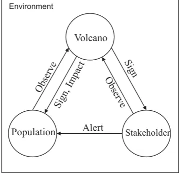
[image:3.544.183.364.446.620.2]In general, the simulation is developed from the relation of the volcano and the surrounding population (Fig. 1). The existing of volcano can be advantageous for this population as well as can be a time bomb because of its activities. When the volcano become active, populations can observe the likelihood but can be difficult to make decisions due to their limitation of knowledge. Therefore, stakeholders, the authorities (government) in this case have significant role to observe and analyse the activities. Proper warnings should be issued by the authorities to alert population when the eruption likely happen. Populations who spatially located in the susceptible areas can be high risk from the impact at that time, so that evacuation should be conducted.
Fig. 1. The Relation of Volcano and Population in Disaster Context. Volcano
Population Stakeholder
Observe
Sign, Impact
Observe Sign
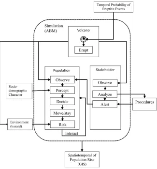
Fig. 2. Conceptual Framework of ABM Simulation.
In the ABM simulation, those three elements represented as agents which interact with the environment. Each agent has certain behavior and mechanism when interacting with the others as well as the environment (Figure 2). In this case, the mechanism is figured as statechart which describe the changing from one to another condition. The environment is represented in spatial data, with agent laid on this with specific geographic location.
Geographically, the location of the volcano as center of hazardous material will take important role in the result. The center of volcano (crater) can be interpreted from the topographic map or satellite imagery. Meanwhile, putting population with specific location which is can be high number individually is challenging. In this simulation, GIS analysis was conducted to prepare the center of the population distribution probability. The result of mean center (center of gravity) analysis (Levine, 1996) of settlement is used to distribute the population of each population unit. The randomness of the distribution of population within specific population unit with the center is generated in AnyLogic using triangular probability distribution (Borshchev, 2013).
3.2. Spatiotemporal Dynamic Setting
As the volcanic activities are dynamic in terms of the magnitude (VEI) and time-based activities, the risk of the area within the hazard zone (See BNPB, 2011) can be dynamic over time. Therefore, the relation of this should be defined well in the model (Table 1 and 2). This matrix can be used to categorize every condition that occur in the simulation as the interaction of various scenarios of VEI, days of crisis length and the extent of the hazard.
Volcano
Stakeholder Temporal Probability of
Eruptive Events
Erupt Simulation
(ABM)
Percept
Decide
Move/stay Observe
Risk
Alert
Interact
Procedures
Socio-demographic Character
Environment (hazard)
Spatiotemporal of Population Risk
(GIS)
Analyze Observe
Table 1. Matrix Relation of Risk Level with Hazard Zone and Time-based Volcanic Activities. Activity (time-based)
Zone
Low Medium High
Low Low Low Low
Medium Low Medium Medium
High Low Medium High
Table 2. Matrix Relation of Risk Level with Volcanic Explosivity Index (VEI) and Hazard Zone. VEI
Zone
1 2 3 4
High High High High High
Medium Medium Medium High High
Low Low Low Low Low
4. The Application Example
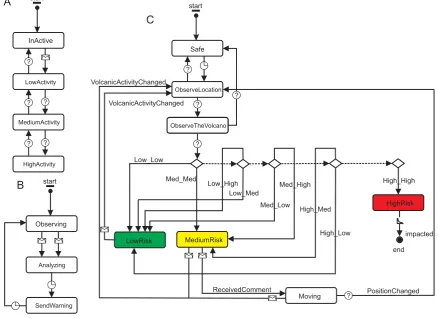
[image:5.544.54.493.315.634.2]Based on the conceptual framework that described previously, agents, properties, rules was created in AnyLogic. The following figure describe the statechart of each agent whereas Fig. 3A is the stakeholder, Figure 3B is the volcano, and Figure 3C is the population. In this statechart, the individual perception has not implemented yet and will be developed in the future work.
Fig. 3. Agents Statechart.
?
?
?
?
?
start
end Safe
ObserveLocation
ObserveTheVolcano
LowRisk MediumRisk
HighRisk
Moving
impacted
PositionChanged ReceivedComment
VolcanicActivityChanged
VolcanicActivityChanged
Low_Low
Med_Med
Low_High Low_Med
Med_Low Med_High
High_Med
High_Low
High_High
C
start
Observing
Analyzing
SendWarning
B
start
InActive
LowActivity
MediumActivity
A
?
HighActivity
? ?
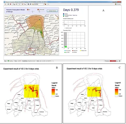
The result of the simulation (Fig. 4A) can be run from AnyLogic portal i.e. http://www.runthemodel.com/models/k-RgpNLa1oojYE1To31FJa. The limitation of this online version is that the route detail from OSM PBF file cannot be employed like offline version. Therefore, the result may different with the reported result. Some experimentation examples from this model have produced for various scenarios of VEI. The possibly impacted population and the position can be saved as spatial data. Therefore, it can be analyzed. These result examples are provided in the Figure 4B - C. In this results, the population locations were analyzed using point density in ArcGIS to provide risk hotspot.
[image:6.544.62.498.151.579.2]See: http://www.runthemodel.com/models/k-RgpNLa1oojYE1To31FJa/
Fig. 4. Application Example of Volcanic Evacuation Model using AnyLogic. A
4. Conclusions
Population risk toward volcanic disaster has spatiotemporal aspect as results of the relation of several agents that can be modeled. Spatially, the risk extent as well as the magnitude can dynamically change over time. Therefore, we recommend that using simulation environment can provide a better understanding of the risk. However, the developed simulation in this article still need to be improved due to several limitation: (1) the variability of population behavior have not involved in this initial simulation development, it will be investigated in the fieldwork, (2) all actors which are involved in disaster management should be considered, (3) the temporal characteristic of volcanic activity during crisis need to be investigated from historical records.
Acknowledgements
The author would like to acknowledge Indonesian Ministry of Research and Higher Education for funding.
References
Ayuningtyas, D., & Gabriel, L. (2013). Respon Masyarakat Terhadap Kebijakan Relokasi Pada Kawasan Rawan Bencana (KRB) (Studi Kasus: Relokasi Desa Glagaharjo). Universitas Gadjah Mada. Retrieved from http://etd.ugm.ac.id/index.php?mod=penelitian_detail&sub=PenelitianDetail&act=view&typ=html&buku_id=66995&obyek_id=4
Bignami, C., Ruch, J., Chini, M., Neri, M., Buongiorno, M. F., Hidayati, S., … Surono. (2013). Pyroclastic density current volume estimation after the 2010 Merapi volcano eruption using X-band SAR. Journal of Volcanology and Geothermal Research, 261, 236–243. http://doi.org/10.1016/j.jvolgeores.2013.03.023
Birowo, M. A. (2010). The use of community radio in managing natural disaster in Indonesia. Bulletin of the American Society for Information Science and Technology, 36(5), 18–21. http://doi.org/10.1002/bult.2010.1720360506
BNPB. (2011). peta kawasan rawan bencana merapi - Google Search. Retrieved 9 October 2015, from http://geospasial.bnpb.go.id/wp-content/uploads/2011/05/2011-04-29_KRB_Area_Terdampak_Langsung_Merapi.pdf
Borshchev, A. (2013). The Big Book of Simulation Modeling: Multimethod Modeling with AnyLogic 6. AnyLogic North America.
Brown, D. G., Riolo, R., Robinson, D. T., North, M., & Rand, W. (2005). Spatial process and data models: Toward integration of agent-based models and GIS. Journal of Geographical Systems, 7(1), 25–47. http://doi.org/10.1007/s10109-005-0148-5
Charbonnier, S., Germa, A., Connor, C., Connor, L., Dixon, T., Komorowski, J.-C., … Preece, K. (2013). The 2010 Pyroclastic Density Currents of Merapi Volcano, Central Java, Indonesia. In EGU General Assembly Conference Abstracts (Vol. 15, p. 6629). Retrieved from http://adsabs.harvard.edu/abs/2013EGUGA..15.6629C
Christia, M. (2012). Experiences of people affected Merapi eruption in 2010: A qualitative study conducted in Krinjing village Indonesia. Retrieved from https://www.duo.uio.no/handle/10852/30048
Church, R. L., & Sexton, R. M. (2002). Modeling Small Area Evacuation: Can Existing Transportation Infrastructure Impede Public Safety? Cova, T. J., & Church, R. L. (1997). Modelling community evacuation vulnerability using GIS. International Journal of Geographical
Information Science, 11(8), 763–784. http://doi.org/10.1080/136588197242077
Damby, D. E., Horwell, C. J., Baxter, P. J., Delmelle, P., Donaldson, K., Dunster, C., … others. (2013). The respiratory health hazard of tephra from the 2010 Centennial eruption of Merapi with implications for occupational mining of deposits. Journal of Volcanology and Geothermal Research, 261, 376–387.
de Bélizal, E., Lavigne, F., Hadmoko, D. S., Degeai, J.-P., Dipayana, G. A., Mutaqin, B. W., … others. (2013). Rain-triggered lahars following the 2010 eruption of Merapi volcano, Indonesia: A major risk. Journal of Volcanology and Geothermal Research, 261, 330–347.
Donovan, K. H. M. (2010). Cultural responses to volcanic hazards on Mt Merapi, Indonesia. University of Plymouth. Retrieved from http://core.kmi.open.ac.uk/download/pdf/10808180.pdf
Donovan, K., Suryanto, A., & Utami, P. (2012). Mapping cultural vulnerability in volcanic regions: The practical application of social volcanology at Mt Merapi, Indonesia. Environmental Hazards, 11(4), 303–323.
Dove, M. R. (2008). Perception of volcanic eruption as agent of change on Merapi volcano, Central Java. Journal of Volcanology and Geothermal Research, 172(3–4), 329–337. http://doi.org/10.1016/j.jvolgeores.2007.12.037
Gilbert, G. N. (2008). Agent-Based Models. SAGE.
Hamacher, H. W., & Tjandra, S. A. (2001). Mathematical modelling of evacuation problems: A state of art. Fraunhofer-Institut für Techno-und Wirtschaftsmathematik, Fraunhofer (ITWM). Retrieved from http://kluedo.ub.uni-kl.de/files/1477/bericht24.pdf
Handford, D., & Rogers, A. (2012). An agent-based social forces model for driver evacuation behaviours. Progress in Artificial Intelligence, 1(2), 173–181. http://doi.org/10.1007/s13748-012-0015-9
Levine, N. (1996). Spatial Statistics and GIS: Software Tools to Quantify Spatial Patterns. Journal of the American Planning Association, 62(3), 381–391. http://doi.org/10.1080/01944369608975702
Malleson, N., See, L., Evans, A., & Heppenstall, A. (2014). Optimising an Agent-Based Model to Explore the Behaviour of Simulated Burglars. In V. Dabbaghian & V. K. Mago (Eds.), Theories and Simulations of Complex Social Systems (Vol. 52, pp. 179–204). Berlin, Heidelberg: Springer Berlin Heidelberg. Retrieved from http://link.springer.com/10.1007/978-3-642-39149-1_12
Marrero, J. M., García, A., Llinares, A., la Cruz-Reyna, S. D., Ramos, S., & Ortiz, R. (2013). Virtual tools for volcanic crisis management, and evacuation decision support: applications to El Chichón volcano (Chiapas, México). Natural Hazards, 68(2), 955–980. http://doi.org/10.1007/s11069-013-0672-4
Marrero, J. M., García, A., Llinares, A., Rodríguez-Losada, J. A., & Ortiz, R. (2010). The Variable Scale Evacuation Model (VSEM): a new tool for simulating massive evacuation processes during volcanic crises. Nat. Hazards Earth Syst. Sci., 10(4), 747–760. http://doi.org/10.5194/nhess-10-747-2010
Mas, E., Suppasri, A., Imamura, F., & Koshimura, S. (2012). Agent-based simulation of the 2011 great east japan earthquake/tsunami evacuation: An integrated model of tsunami inundation and evacuation. Journal of Natural Disaster Science, 34(1), 41–57.
Mei, E. T. W., & Lavigne, F. (2012). Influence of the institutional and socio-economic context for responding to disasters: case study of the 1994 and 2006 eruptions of the Merapi Volcano, Indonesia. Geological Society, London, Special Publications, 361(1), 171–186. http://doi.org/10.1144/SP361.14
Mei, E. T. W., & Lavigne, F. (2013). Mass evacuation of the 2010 Merapi eruption. International Journal of Emergency Management, 9(4), 298– 311. http://doi.org/10.1504/IJEM.2013.059871
Mei, E. T. W., Lavigne, F., Picquout, A., de Bélizal, E., Brunstein, D., Grancher, D., … Vidal, C. (2013). Lessons learned from the 2010 evacuations at Merapi volcano. Journal of Volcanology and Geothermal Research, 261, 348–365. http://doi.org/10.1016/j.jvolgeores.2013.03.010
Mei, E. T. W., Lavigne, F., Picquout, A., & Grancher, D. (2011). Crisis Management During the 2010 Eruption of Merapi Volcano. In Regional Geographic Conference–International Geographical Union, Santiago, Chile (pp. 15–19). Retrieved from http://www.acreditacion.fisa.cl/ugi/archivo_presentacion/201109050300_20112211wvgz7h_archivo_presentacion.pdf
Nagarajan, M. (2014). An operational research-based integrated approach for mass evacuation planning of a city. Aston University. Retrieved from http://eprints.aston.ac.uk/22198/
Nuzulia, Y., & Sudibyakto, S. (2014). kajian penolakan relokasi oleh warga terdampak erupsi merapi tahun 2010 (studi kasus di dusun kalitengah lor, DIYdan dusun Sambungrejo JawaTengah). Universitas Gadjah Mada. Retrieved from http://etd.ugm.ac.id/index.php?mod=penelitian_detail&sub=PenelitianDetail&act=view&typ=html&buku_id=66452&is_local=1
Pidd, M., de Silva, F. N., & Eglese, R. W. (1996). A simulation model for emergency evacuation. European Journal of Operational Research, 90(3), 413–419. http://doi.org/10.1016/0377-2217(95)00112-3
Posko Set Bakornas PBP. (2006). Penanganan Gunung Merapi: Laporan Posko, 16 Juni 2006. Set. BAKORNAS PBP. Retrieved from http://118.97.53.73/userfiles/file/buletin/Buletin%20Merapi16.pdf
Sagala, S., & Okada, N. (2009). F-2 Statistical analysis of correlation between hazard-related factors and households’ evacuation decisions in Mt. Merapi. Proceedings of the Annual Conference of the Institute of Social Safety Science, (24), 61–64.
Šalamon, T. (2011). Design of Agent-Based Models. Tomáš Bruckner.
Silva, F. N. de, & Eglese, R. W. (2000). Integrating Simulation Modelling and GIS: Spatial Decision Support Systems for Evacuation Planning. The Journal of the Operational Research Society, 51(4), 423–430. http://doi.org/10.2307/254169
Srbljinoviü, A., & Škunca, O. (2003). An Introduction to Agent Based Modelling and Simulation of Social Processes. Interdisciplinary Description of Complex Systems, 1(1-2), 1–8.
Tan, L., Hu, M., & Lin, H. (2015). Agent-based simulation of building evacuation: Combining human behavior with predictable spatial accessibility in a fire emergency. Information Sciences, 295, 53–66. http://doi.org/10.1016/j.ins.2014.09.029
Uno, K., & Kashiyama, K. (2008). Development of simulation system for the disaster evacuation based on multi-agent model using GIS. Tsinghua Science & Technology, 13, 348–353.
Utami, P. (2008). Measuring Social Vulnerability in Volcanic Hazards: The Case Study of Merapi Volcano, Indonesia, Earth Sciences. MSc thesis, University of Bristol, Bristol.
van Dam, K. H., Nikolic, I., & Lukszo, Z. (2012). Agent-based modelling of socio-technical systems (Vol. 9). Springer Science & Business Media. Retrieved from https://books.google.co.uk/books?hl=en&lr=&id=rpLBkl-1_7QC&oi=fnd&pg=PR3&dq=agent-based+modelling+of+socio-technical+system&ots=mQs-SxYWi2&sig=g0gUcHqWAkRDWvKwE8iqVSqkxj0
Yang, B., Ren, B., & Wu, Y. (2012). The Research of Multi-Resolution Modeling and Simulation of the Emergency Evacuation. Procedia Engineering, 29, 3110–3116. http://doi.org/10.1016/j.proeng.2012.01.450
Yang, L., Liu, Q., Yang, S.-H., & Yu, D. (2015). Evacuation Planning with Flood Inundation as Inputs. Retrieved from http://iscram2015.uia.no/wp-content/uploads/2015/05/3-c.pdf