University of Southern Queensland
Faculty of Engineering and Surveying
Simulation of GPS Car Navigation Systems
in Evaluating the Impact of Poor Quality
Road Data
A dissertation submitted by
Benjamin Tart
in fulfilment of the requirements of
Courses ENG4111 and ENG4112 Research Project
towards the degree of
Bachelor of Spatial Science (Surveying)
Submitted: October, 2008
Abstract
This dissertation was formulated to research the impacts that road network data errors and their associated navigation errors have on driver safety. Simulation of GPS NMEA data allows navigation testing of roads that were identified to have poor quality road network data. The navigation errors were found by comparing the navigation paths with reality and the severity of these errors were tested by replaying this data to a group of drivers.
The results indicate that poor quality road network data can cause problems with respect to driver safety. These problems are more pronounced on busy major roads, especially freeways and urban highways. All roads tested in this project were chosen due to their various locations and the variety in the overall nature of the roads, ranging from a country road to a busy freeway.
Several problems were identified that may attribute to the cause of navigation errors. They range from software functions in the satellite navigation system to the prolonged period of updating road network data by different levels of government and mapping companies. An innovative set of solutions has been formulated, which include the automatic mapping of erroneous roads and the regular updating of road network data. This can be facilitated through better practices by governments and mapping companies, plus voluntary updating of maps by civilians.
University of Southern Queensland
Faculty of Engineering and Surveying
ENG4111 & ENG4112
Research Project
Limitations of Use
The Council of the University of Southern Queensland, its Faculty of Engineering and Surveying, and the staff of the University of Southern Queensland, do not accept any responsibility for the truth, accuracy, or
completeness of material contained within or associated with this dissertation. Persons using all or any part of this material do so at their own risk, and not at the risk of the Council of the University of Southern Queensland, its Faculty of Engineering and Surveying or the staff of the University of Southern
Queensland.
This dissertation reports an educational exercise and has no purpose or validity beyond this exercise. The sole purpose of the course pair entitled “Research Project” is to contribute to the overall education within the student’s chosen degree program. This document, the associated hardware, software, drawings, and other material set out in the associated appendices should not be used for any other purpose: if they are so used, it is entirely at the risk of the user.
Certification
I certify that the ideas, designs, and experimental work, results, analyses and conclusions set out in this dissertation are entirely my own effort, except where otherwise indicated and acknowledged.
I further certify that the work is original and has not been previously submitted for assessment in any other course or institution, except where specifically stated.
Benjamin Jeffrey Tart
Student Number: 0050025049
Signature
Acknowledgements
This research was carried out under the principal supervision of
Associate Professor Kevin McDougall and Mr. Peter Gibbings. I would like to thank both Kevin and Peter for their assistance in all stages of this project and for their patience and encouragement they provided to me throughout the duration of this project.
Appreciation is also due to Dr. Andrew Maxwell, of the Faculty of Engineering and Surveying. His assistance in the development of the simulator was the key to its prompt development. Appreciation is due to the volunteers who put aside their time to participate in the driver
surveys. Their contributions were necessary to gain the results achieved in this project.
I would like to acknowledge and thank my employer, Ardill Payne & Partners in Ballina, for their support and assistance for the entire duration of this project. Their assistance with allowing me leave from work plus compiling the final thesis is very much appreciated.
Table of Contents
Abstract... 3
Certification ... 5
Acknowledgements ... 6
Table of Contents ... 7
List of Figures ... 9
List of Tables ... 9
Chapter 1 - Introduction ... 10
1.1 Statement of the Problem ... 11
1.2 Project Aim ... 12
1.3 Key Research Objectives ... 12
1.4 Justification of Research ... 13
1.5 Structure of Dissertation ... 13
1.6 Limitations of this project ... 14
Chapter 2 - Literature Review... 16
2.1 Introduction ... 17
2.2 Desired Outcomes of Literature Review... 17
2.3 GPS Vehicle Navigation Systems ... 18
2.3.1 Technical Capabilities ... 18
2.3.2 Uses ... 19
2.4 Navigation Data ... 20
2.4.1 Sources of Navigation Data ... 20
2.4.2 Quality Issues ... 23
2.4.3 Map and Data Providers in Australia ... 24
2.5 GPS Simulation ... 25
2.5.1 Raw GPS Data... 26
2.5.2 NMEA Data ... 27
2.5.3 Communications ... 29
2.6 Risk Assessments ... 30
2.7 Conclusion ... 31
Chapter 3 - Project Method... 32
3.1 Introduction ... 33
3.2 Overview of Project Method ... 34
3.2.1 Project Background... 34
3.2.2 Develop a GPS Simulator ... 34
3.2.3 Identify GPS Test Sites... 35
3.2.4 Test the Simulator in a Range of Areas... 36
3.2.5 Evaluate the Outcomes... 36
3.2.6 Recommend Future Development... 36
3.3 Initial Satellite Navigation System Testing ... 37
3.4 Development of GPS Simulator... 38
3.5 Collection of NMEA Data ... 40
3.6 Simulator Setup for NMEA Data Transfer ... 43
3.7 Monitor Satellite Navigation System for Navigation Errors on Missing Roads... 45
3.7.1 Missing Roads- Pacific Highway, Brunswick Heads, NSW ... 45
3.7.2 Missing Roads- Elevation & Aspects on Lennox, Lennox Head, NSW ... 46
3.7.3 Missing Roads- Hogbin Drive, Coffs Harbour, NSW ... 46
3.8 Monitor Satellite Navigation System for Navigation Errors on Excessive Data Roads .. ... 47
3.8.1 Excessive Data Roads- Acacia Street, Killarney, QLD... 47
3.8.2 Excessive Data Roads- First Avenue, Lismore, NSW ... 49
3.8.3 Excessive Data Roads- Loveday Road, Cooby Dam, QLD... 50
3.9 Survey of Drivers ... 51
3.10 Risk Assessment ... 52
3.11 Formulation of Further Recommendations... 53
Chapter 4 - Results ... 54
4.1 Introduction ... 55
4.2 Satellite Navigation System Testing ... 55
4.3 Suitability of GPS Simulator ... 58
4.4 Navigation Error Results... 59
4.4.1 Navigation Error Results- Pacific Highway, Brunswick Heads, NSW... 59
4.4.2 Navigation Error Results- Elevation & Aspects on Lennox, NSW ... 60
4.4.3 Navigation Error Results- Hogbin Drive, Coffs Harbour, NSW... 62
4.4.4 Navigation Error Results- Acacia Street, Killarney, QLD... 63
4.4.5 Navigation Error Results- First Avenue, Lismore, NSW ... 64
4.4.6 Navigation Error Results- Loveday Road, Cooby Dam, QLD... 65
4.5 Driver Reaction Results ... 66
4.5.1 Driver Reaction Results- Pacific Highway, Brunswick Heads, NSW ... 67
4.5.2 Driver Reaction Results- Elevation & Aspects on Lennox, NSW ... 69
4.5.3 Driver Reaction Results- Hogbin Drive, Coffs Harbour, NSW ... 70
4.5.4 Driver Reaction Results- Acacia Street, Killarney, QLD ... 73
4.5.5 Driver Reaction Results- First Avenue, Lismore, NSW ... 75
4.5.6 Driver Reaction Results- Loveday Road, Cooby Dam, QLD ... 76
4.6 Conclusion ... 78
Chapter 5 - Discussion & Recommendations... 79
5.1 Introduction ... 80
5.2 Risk Assessments ... 80
5.2.1 Risk Assessment for Pacific Highway, Brunswick Heads, NSW ... 81
5.2.2 Risk Assessment for Elevation & Aspects on Lennox, NSW... 82
5.2.3 Risk Assessment for Hogbin Drive, Coffs Harbour, NSW ... 83
5.2.4 Risk Assessment for Acacia Street, Killarney, QLD ... 84
5.2.5 Risk Assessment for First Avenue, Lismore, NSW ... 85
5.2.6 Risk Assessment for Loveday Road, Cooby Dam, QLD ... 86
5.3 Discussion & Comparisons... 86
5.4 Recommendations & Solutions ... 89
5.4.1 Less Snapping Offset Distance ... 89
5.4.2 Public Mapping Databases ... 90
5.4.3 Additional Changes to Snapping Function ... 91
5.4.4 Use of Online Facilities for Error Reporting ... 94
5.4.5 Alternative Route Calculation ... 94
5.4.6 Communication between Governments and Mapping Companies ... 95
5.4.7 Automated Mapping... 96
5.4.8 Confirmation of Accuracy of Data from Governments ... 97
5.5 Conclusion ... 98
Chapter 6 - Conclusion ... 100
6.1 Introduction ... 101
6.2 Review of Research Objectives... 101
6.3 Project Conclusion... 103
6.4 Future Research ... 104
6.5 Potential Future Uses of the Simulator... 105
6.6 Closure ... 106
List of References ... 107
Appendix A... 112
Appendix B ... 114
List of Figures
Figure 2.1- Risk Assessment Combining Likelihood and Impact 31
Figure 3.1- Project Method 34
Figure 3.2 – Ruler Function in Google Earth 38
Figure 3.3 – GPS Simulator 39
Figure 3.4 – ASUS A696 PDA Satellite Navigation System 40
Figure 3.5 – Cursor on Road in Google Earth with Coordinates Displayed at Bottom of Screen
42
Figure 3.6 – Bluetooth COM Ports 43
Figure 3.7 – COM Port Options in GPS-NMEA Monitor 44
Figure 3.8 – Play/Pause Buttons in GPS-NMEA Monitor 44
Figure 3.9 – Pacific Highway, Brunswick Heads 45
Figure 3.10 – Acacia Street, Killarney 48
Figure 3.11 – North-west Entrance to Acacia Street, Killarney 48
Figure 3.12 – First Avenue, Lismore 49
Figure 3.13- Entrance to First Avenue, Lismore 50
Figure 3.14 – Loveday Road through Cooby Dam 51
Figure 3.15- Loveday Road through Boat Ramp Sign 51
Figure 4.1 – Location of State Survey Marks Used for Testing 57
Figure 4.2 – Elevation and Aspects on Lennox (Roads Driven in Yellow) 61
Figure 4.3 – Hogbin Drive, Coffs Harbour (Roads Driven in Yellow) 62
Figure 4.4- Jumping/Snapping Results 68
Figure 4.5- Reaction when Driver Realises Roundabout Does Not Exist 68
Figure 4.6- Reaction when Driver Enters Area with No Navigation 69
Figure 4.7- Reaction to Second Loss of Navigation 70
Figure 4.8- Northern Section of Hogbin Drive (in Yellow) 71
Figure 4.9- Driver Reaction to No Navigation (Hogbin Drive) 72
Figure 4.10- Driver Reaction to Approaching Creek (Hogbin Drive) 72
Figure 4.11- Driver Response to No Right-turn Road (Acacia Street) 74
Figure 4.12- Driver Response to Restricted Right-hand Turn (First Avenue) 76
Figure 4.13- Driver Response to Dam on Road (Loveday Road) 77
Figure 5.1- Risk Assessment Calculation for Pacific Highway, Brunswick Heads, NSW 81
Figure 5.2- Risk Assessment Calculation for Elevation & Aspects on Lennox, NSW 82
Figure 5.3- Risk Assessment Calculation for Hogbin Drive, Coffs Harbour, NSW 83
Figure 5.4- Risk Assessment Calculation for Acacia Street, Killarney, QLD 84
Figure 5.5- Risk Assessment Calculation for First Avenue, Lismore, NSW 85
Figure 5.6- Risk Assessment Calculation for Loveday Road, Cooby Dam, QLD 86
Figure 5.7- Relative Geographic Location of All Examples 88
Figure 5.8 – Road Network of Linked Roads 92
Figure 5.9 – Watsonia Avenue & Brodie Drive both parallel to Hogbin Drive (Yellow Line) 93
List of Tables
Table 4.1 – Results of Point Accuracy 56 Table 4.2- Human Injuries Consequences 67 Table 4.3- Driver Evaluation for Pacific Highway, Brunswick Heads, NSW 69 Table 4.4- Driver Evaluation for Elevation & Aspects on Lennox, NSW 70 Table 4.5- Driver Evaluation for Hogbin Drive, Coffs Harbour, NSW 73 Table 4.6- Driver Evaluation for Acacia Street, Killarney, QLD 75 Table 4.7- Driver Evaluation for First Avenue, Lismore, NSW 76 Table 4.8- Driver Evaluations for Loveday Road, Cooby Dam, QLD 77
Chapter 1
1.1 Statement of the Problem
Modern GPS satellite navigation systems can experience navigation problems whilst using the uploaded on-board maps. These problems are mainly associated with missing data from the on-board maps or navigation along roads that are missing in the real-world.
Over the past decade GPS satellite navigation systems have grown in popularity and their ability to reliably navigate drivers to a desired destination. Schekutiev (2006) suggested that an effective satellite navigation system would depend on the user’s measuring-navigating equipment being of good quality. Successful navigation also depends on the accuracy of maps that are loaded into the individual systems, which can vary in positional quality. New roads are continually being created so the updating of new road data is critical in successful navigation. Montenbruck & Holt (2002) stated that in an S/A (Selective Availability) free environment, the modelled GPS time typically agrees with true GPS time to within 30 metres. Therefore, accuracy of GPS data from satellites is considered to be quite dependable.
Various companies supply electronic maps for satellite navigation systems. There are a range of methods employed in collecting road network data. When new roads are constructed, the different
companies that provide this road network data must keep their maps up-to-date by collecting and then adding the new data to their
databases. The lack of data can lead to the suspension of any
navigation even if the on-board GPS is still providing position data. This is relevant also to areas where too much data exists. Road data can be stored in their databases but the roads are non-existent or unusable in the real world.
modern communication methods. The simulation of GPS data has been successful in different ways. Brown, Gerein and Taylor (2000) used a GPS simulator that simulated various factors in the operation of the overall Global Navigation Satellite System (GNSS), including
trajectory of the receiver(s), the signal power and environmental effects. Our goal is to get a system that is relatively easy to run and to use modern technologies in the development of a simulator.
1.2 Project Aim
The aim of this project is to develop a GPS simulator and assess the impact of poor quality road network data in car satellite navigation systems.
1.3 Key Research Objectives
The purposes of this project are to complete the following key research objectives; these specifications are agreed and signed in Appendix A:
1) Review GPS car satellite navigation systems, the suppliers of road network data to satellite navigation systems available in Australia and the sources of this data.
2) Investigate the data formats that can be used in simulation of GPS signals (both pre-processed and post-processed) and the use of this data in specific stages of simulation.
3) Assess the quality of different road network data sources and compare the data in different geographic areas.
4) Simulate GPS signals through computer-based simulators to achieve a navigation path to a specific destination.
6) If time permits, Investigate advanced simulation to achieve a similar road path to driver’s expectation.
1.4 Justification of Research
Most persons who own a Satellite Navigation System (sat-nav) would most likely be able to tell of some problems they have encountered with the operation of the system. Problems encountered with using a satellite navigation system includes incorrect navigation due to
excessive data in the maps or the ceasing of navigation due to a lack of map data. The confusion due to the specified route chosen by the system and its justification is also a regular problem but is not a specification in this thesis.
Because satellite navigation systems are available from many different retail stores around the world, continued sales pressures may override the maintenance of good quality data contained in a system. There are concerns about driver safety; therefore these issues need to be
resolved whilst maintaining their popularity amongst the general public.
This thesis is will set out to achieve some answers to some specific problems that pertain to Satellite Navigation Systems and their problems associated with location information. Their effects on the safety of road-users will be evaluated and recommendations on further research and development will be given.
1.5 Structure of Dissertation
This dissertation has six chapters, with each chapter written in the order of the research conducted and completed. These chapters will cover different stages from the introduction and the literature review through to the research work, results, recommendations and the conclusion.
at issues ranging from GPS car navigations systems to
communications and simulation techniques and risk assessment methods.
The project method will be discussed after the literature review. This chapter will detail the proposed methods of conducting all testing, research, analysis and presentation of results. This section will outline the development of the final GPS simulator and how it will be used in the simulation experiments. A discussion of the intended roads to be used in the experiments will also be presented.
The results chapter will present the errors found in our testing and the driver survey results. These errors will be extracted through the
analysis of the differences between the roads in the satellite navigation system (and the navigation) and the roads in the real-world. Results concerning a survey of these errors with drivers and the resultant risk assessments will be presented in this chapter.
A chapter dedicated to a discussion and recommendations for the improvements required to the functioning of car navigation systems will follow the results chapter. Each example used in this project will be discussed and the potential impacts on driver safety will be analysed. Recommendations will be made in response to specific problems incurred in the operation of the satellite navigation system.
This dissertation will conclude in chapter six (6), which will be a
response to the issues put forward in chapter one (1). It will outline the achievements made with respect to the project aim and the research objectives.
1.6 Limitations of this project
The development of the simulator is a major aim of this project. But in the early stage of the project it is a visionary concept and if its
development is deemed unsuccessful then it would prove to be a major limitation. Although the concepts for the development of this simulator are envisioned, each individual step towards attaining simulation must take place before the development is completed.
The GPS satellite navigation system to be used in this project will have a specific type of on-board maps and navigation program. The
characteristics of this program will determine the reactions displayed on the satellite navigation system, in response to low quality road network data. The success of the communications, either through Bluetooth or cable will depend on the initial testing. If Bluetooth is deemed to be unsuccessful during our testing stage, we will need to resort to using a cable connection, such as USB. If this occurs then data transmission and the speed of this transmission will be restricted by the type of cable and how fast the computer can process data using that cable.
Chapter 2
2.1 Introduction
This chapter seeks to provide an update of the literature that exists today that pertains to this project, including issues like GPS simulation, collection of road network data, Bluetooth technologies and risk
assessments. It will give some perspective in what is known from past research and then use this knowledge to assist with the research proposed in this dissertation. This chapter will explain what is known with respect to GPS simulation, collection of road network data and car navigation systems.
The aim of this chapter is to explain the outcomes of a literature review conducted that will give background information regarding this project.
To achieve the aim for this chapter, research will be conducted using journal databases that are accessible through the University of Southern Queensland. Reviews of the relevant journals will be made and a collection of these journals will combine to form the final
literature review.
2.2 Desired Outcomes of Literature Review
This project is seeking to evaluate the overall dependency of available maps that are supplied to GPS satellite navigation systems. Therefore we are not evaluating the accuracy of GPS satellite data, but the data provided in electronic map form. The companies that supply this data can update their databases as often as they see fit. Australia and its population are spread out over a large area and the updating of road navigation data on a national scale can prove difficult.
This review will look at the basics of GPS and the current status of satellite navigation systems, the methods used to obtain road
understand the types of data that are used in the overall process of the GPS and every aspect that goes into the single unified operation of a satellite navigation receiver. From this, a better understanding of the errors and their potential for navigation problems will be achieved.
2.3 GPS Vehicle Navigation Systems
GPS or the Global Positioning System was developed by the United States Department of Defence. It was the first constellation of satellites put into orbit around the Earth for the purpose of accurately locating a position on the Earth. Gibbings (2005) explains the ease of using GPS-it is accessible 24 hours a day, seven days per week, anywhere on earth and in all weather. Today new GPS handheld receivers have the capability of communicating with more than one navigation system. GLONASS (GLObal NAvigation Satellite System) is the Russian equivalent of the United States-owned Global Positioning System. It contains fewer satellites than its American equivalent but can provide equal standard of positional accuracy. A basic GPS receiver requires communication with a minimum of four (4) satellites to get a single position fix anywhere on Earth. It is possible to derive your position with only three (3) satellites, but a fourth satellite signal will ensure a check of your determined position.
In the past the GPS system was subject to deliberate degradation of the signal, thus had an effect on the accuracy. This was intentional by the United States Department of Defence for security purposes. This degradation was called Selective Availability (S/A) but was shut down on 1st May 2000. Ochieng & Sauer (2002) suggest that GPS satellite navigation could address problems like traffic congestion levels, risk of accidents and time wastage during journeys. Issues concerning safety could suggest one reason why S/A was turned off.
2.3.1 Technical Capabilities
point A to point B, functions can be set in order for the system to calculate the shortest distance in the road network between both points. If the driver follows this path but chooses to divert from the chosen path then the system is able to recalculate a new shortest route. Options exist for the avoidance of specific points in the network like tolls booths or busy highways.
As satellite navigation systems advance in capabilities, new
possibilities are always realised by the visionaries. Mossberg (2008) suggested that in-car navigation devices could become smarter
through direct communication with the Internet and report on the speed of traffic further along a road in real-time. He reports that a new system is available with the capacity to perform such functions. It depends also on the number of similar units that exist along the road at the same time.
Safety issues associated with operating these devices whilst driving are being addressed continuously. Quain (2007) reported that newer devices have voice receiver microphones built into them so that a driver can “bark out” the address of their destination. This can avoid the distraction of typing the address in while driving (thus increasing
safety). Other new features like 3-D views of complex intersections are available in specific systems. These views are only available at this stage for major intersections in the United States.
2.3.2 Uses
Other miscellaneous options are included in many satellite navigation systems available today. Garmin (2008) offer systems with speak commands and wireless connections to the Internet for information on weather, traffic, fuel prices and news. Navman (2007) offer systems with cameras built-in and TomTom (2008) has speed alert functions.
2.4 Navigation Data
The sole purpose for the existence of roads is to facilitate the transportation of people and objects as quickly as possible from a starting location to a destination. However, there must be information available that informs travellers of the localities along a specific road and distances to and between them. In the past this information would be available through the purchase of paper maps of major towns in the region (depending on the scale of the maps). Today there is a large e-map industry with the availability of electronic e-maps free over the internet plus options available to purchase electronic maps for use in hand-held computers and satellite navigation systems. These
electronic maps are today beginning to take over from their
predecessors, the paper maps. There are many other possibilities with using electronic maps- including navigation (with its linkage to GPS), electronic mobility and the ability to update maps without purchasing an entire module (or paper atlas).
2.4.1 Sources of Navigation Data
Basically there are five methods of collecting road network data.
Traditional Surveying Methods
GPS Data Capture
Extraction through Remote Sensing
Extraction from Aerial Photographs
Video Recordings of Roads
The traditional methods of recording location data of roads were surveying methods where bearings and distances would define the locations of road reserves. These dimensions were presented on survey Plans that would become registered under the relevant state Register. As of today surveyors are continually responsible for these types of duties. Roads are typically surveyed today for the purposes of land access. But survey data of roads are not always reliable in terms of an existent road in the real world. Roads legally exist in Australia whether a satisfactory road surface exists within it or not. But if there is no existing road surface like bitumen or concrete then successful navigation, using this type of data, can prove ineffective.
GPS data capture is the most effective, accurate and fastest method of recording road network data today. It is the easiest method of
extracting road data as it can be as simple as fixing a GPS receiver onto a car and driving the routes while regularly recording location data. However, there is metadata to consider, such as width of roads, the names of the roads and the class of road (collector, arterial or local access roads). There are road network data providers in Australia that collect and update their databases using this method.
Extraction from remote sensing is a means of collecting data of the Earth’s surface using satellites and high altitude aircraft. Data can be changed around to be interpreted differently or for a certain purpose. The extraction of road network data would be achieved by the
using the sample to identify all the common areas in an image. Lacoste, Descombes & Zerubia (2003) found that this method of generating road network data has some potential, describing it as ‘encouraging’. Nevertheless, there are problems with noise, especially with trees covering roads. This can lead to incomplete data which would require further data detection using other methods. This method of collecting road navigation data is not reliable enough for use on a large scale. Goeman et al. (2005) suggests that remote sensing methods could be a tool for checking the accuracy of existing road network data. However, the technology available is always improving. Improvements in the imagery obtained using technology in the future will give opportunities of utilising remotely sensed data to extract road network data in a large scale.
Extraction of road network data from aerial photographs occurred for purposes other than for GPS satellite navigation. This data would be produced for basic map production, where accuracy was not important. In the past this location data was collected through digitizing of the images. With the advent of GIS these images are being used in electronic formats and data is extracted using algorithms set by the user and this data is produced faster and more accurately than
digitizing. Gervin & Ragan (1993) conducted tests on the production of road and house data from aerial photography. The ability to view images in different bands (including infrared) and in false colours can greatly assist in their search for a single ‘customised’ object search in a single image.
Recording videos of roads is an option that is open for those needing to extract road data on a small scale. Normally this type of information is recorded as such for more than only mapping purposes. Harris et al. (1992) used the video data of roads recorded in Doncaster
in a road network whilst recording the video of the road. Other methods of this type of data collection, such as aerial video data capture used by Pless & Jurgens (2004), use ‘geo-referenced’ video data that
capture the distribution of relative movements between frames (spatio-temporal). Each pixel in each image is given a score based on a given function. The score determines the likelihood that this pixel represents an image of a road.
2.4.2 Quality Issues
Successful navigation of a driver along a given road requires some knowledge of the positions of their starting and finishing points, plus the road/s between these two points. Quality issues are defined as data that is included or missing from maps which can obstruct the process of satellite navigation. Two basic possibilities can occur here.
Lack of road network data in the maps used for navigation.
Included content of surveyed roads that are not used by everyday traffic.
The difference between what a map shows as a representation of the real world compared to reality can be quite different. In Australia it is not uncommon to be travelling along a road where suddenly, a satellite navigation system ceases to operate due to the absence of data on the travelled section of road. This is evident in new roads, whether it’s a new freeway or a new access road in a recently completed subdivision.
Quality issues link with the problems of the containment of excessive data, that is, road data which occurs in maps that represent surveyed roads, but which are not open to traffic. Many of these roads are fenced areas in a rural paddock that connect to an open road.
instances can raise questions about the safety of drivers using these navigation systems, especially when you consider the ‘worst-case’ possibilities. Instances like driving roads at night where a driver has no prior knowledge of the road could lead to problems with safety,
especially if there is traffic following the driver. Navigation systems would operate best when data of the status of roads is included with their metadata.
2.4.3 Map and Data Providers in Australia
The providers of commercially available road map data in Australia have a prime responsibility of maintaining the currency of their datasets. Australia is a large country with a small population, which makes this task more difficult than on other continents like Europe and North America.
Today there are two main providers of road network data for use in satellite navigation systems
Navteq
Sensis
Navteq is based in the United States and they are the major suppliers of road network data for satellite navigation systems in North America and Europe. In 2007 Navteq entered the Australian GPS satellite navigation map provider market, adding some competition to the previous sole provider of this data, Sensis. Navteq provides data to large Internet companies like Google and Yahoo. Their maps were produced by driving all roads around Australia and capturing this data using GPS plus added data from PSMA (Public Sector Mapping Agencies).
Zealand. Their road maps are used in the majority of satellite
navigation systems used in Australia, including Garmin, Navman and TomTom. Whereis source their data from UBD, which are the major paper-based street directory supplier in Australia. UBD source this original data similar to Navteq- through data collection using GPS. Furthermore, UBD receives their data from local councils and state government road authorities.
Both of these suppliers provide basic options in their navigation, for example, different methods of route calculations (eg: avoiding tolls or highways), Poi’s (points of interest) and safety alert points like speed cameras.
2.5 GPS Simulation
The concise Macquarie dictionary of the English language 2001 defines ‘simulation’ as “pretending; feigning”. It also defines it as “the representation of physical systems, phenomena by computers”. Some types of simulation can involve replicating natural phenomenon in the real world by their simulation using computers. GPS simulation
involves the replication of GPS signals or data using computer programs to reflect real world positioning. GPS can be simulated for several different purposes. Brown, Gerein & Taylor (2000) developed a MATLAB product that allows software simulation of complex GPS environments. This includes the effects of interfering source signals and antenna and receiver characteristics on the received GPS signals. Their simulator brought about these advantages:
The ability to simulate specific conditions as often as necessary; and
The ability to save exact RF (radio-frequency) conditions for historical and legal purposes.
error, atmospheric errors (ionosphere and troposphere) and user-defined errors. It is used to simulate surveying-grade GPS receivers along with typical code-phase GPS receivers, like those found in satellite navigation systems. Hannah (2001) simulated the effects of multipath on GPS receivers. Development of a simulator took place and it required testing in the real-world to evaluate the accuracy of the simulator.
2.5.1 Raw GPS Data
Raw signals from GPS satellites provide receivers with much
information. They contain modulated codes that give us an ability to calculate pseudo-ranges between satellites and receivers. This is achieved by calculating the amount of time from the transmission of the signal to its receiving. All GPS receivers know what the codes are at any given time from any satellite. When they receive the signals, the receivers calculate the difference in time between the transmission of this code from the satellite and when it is received. The pseudo-range can be known from all satellites visible to the receiver. Measurements using these codes are accurate to about 10-15 metres at any given time.
Included with these modulated codes are Ephemerides and Almanac data. Almanac data is given to GPS receivers to aid in satellite
searches in the future. It uploads data of the positions of the satellites for a specific amount of time in the future. Broadcast ephemerides are data that corresponds with factors that affect all satellites. This includes data on eccentricity, satellite health, clock bias information and other orbital information like mean motion and right ascension (and its rate).
The quality of the raw satellite signals are continually improving. Today there are two codes accessible to civilians- C/A code, which is
2.5.2 NMEA Data
NMEA, which stands for National Marine Electronics Association is a type of data used to communicate between electronic equipment, including GPS. In the context of GPS, this is the output data of the position fixes calculated by the GPS receiver. They are expressed as sentences, which contains information completely for intended purpose of the electronic equipment. For example the following is a NMEA sentence transmitted from a GPS receiver:
$PMGNTRK,2852.109,S,15333.636,E,00011,M,024255.18,A,,100408* 6C
$PMGNTRK represents Magellan GPS receiver track log. 2852.109, S, is the latitude of the measured point.
15333.636, E, is the longitude of the measured point.
00011,M, is the elevation and the unit of measure (metres in this case). 024255.18 is universal time (in 24 hour time).
A signifies Active, where V could mean Void. 100408 is the date of string creation.
*6C is the checksum, which is used by programs to ensure no errors are present in the data caused by transmission (Baddeley, 2001).
In GPS there is a minimum amount of data required in the NMEA sentences for a GPS receiver to effectively read incoming data. This data includes coordinates, plus other statistics and almanac data. Four types of sentences are sufficient for all GPS receivers. They are called:
o GGA
o RMC
o GSA
o GSV
and Elevation data, plus a number score (from 0-8) which determines the quality of the position (eg: GPS fix = 1 while RTK Fix = 4).
RMC stands for Recommended Minimum Sentence (C) and contains very basic coordinate data. They contain data on GPS PVT (Position, Velocity and Time) like Velocity of user in knots, plus the track angle compared to true north.
GSA (GPS DOP and active satellites) provides data on the nature of the position fix. This sentence contains data about the satellites used to initiate a position fix, the values of different DOP’s (dilution of precision) plus data on the nature of the position fix (eg: 2D, 3D or no fix).
GSV (GPS satellites in view) is a sentence specially designated to communicate data about the satellites used in the position fix. As each of these sentences can only provide data for only four satellites at a time, more than one sentence may need to be sent to communicate all available data. Data included in this sentence includes the sentence number, number of satellites in view, satellite number, elevation and azimuth, plus the SNR (signal-to-noise ratio) which is an indicator of the strength of the signal.
NMEA strings are either stored as a file or transmitted to a form of visual display, like a map. In satellite navigation systems, NMEA strings are sent to the programs where the data is analysed and instantaneous positions are compared against on-board maps. Strings are sent
frequently, which provides a flow of movement along the monitor, which displays the position of the driver.
The NMEA sentence shown above is only one example of many
different types of NMEA sentences, which can contain numerous types of different data. Types of data that can be included in a NMEA
satellites in view, bearings and distances and height data. Even additional information like weather (temperatures, wind speed and direction) and estimated positional error can be included in NMEA sentences.
2.5.3 Communications
There is some different ways of achieving a simulation of GPS data. But it would be difficult and impractical to simulate anything inside the single unit (eg: computer). We seek to simulate GPS data using a GPS receiver but bypassing the actual GPS signal position fixes obtainable in receivers. Instead we would seek to stream the NMEA data into the GPS receiver so that travelling around in the real world during this project is kept to a minimum. Basically, communication is necessary between a computer that is streaming NMEA data and a GPS receiver that can receive this data and use it to drive a path. Two options are available- using cables or wireless communications.
Cables will simply plug into both devices and attach each other for direct communication. The main problem is the speed of transfer of data would be limited to one speed (the speed the cable is designed and built for). Other limitations include specific plugs in both devices and the lengths of cables. Although good cable technology is available (e.g. USB), wireless technology is available for communication
between such peripherals.
Bluetooth is a wireless technology that enables portable electronic devices to connect and communicate wirelessly through short-range,
alternative to cables. Bluetooth is the ‘stand-out’ communication means because of its ease of use and the fact that it is the latest technology in the wireless arena.
2.6 Risk Assessments
The purpose of a risk assessment is to calculate the likelihood of an event occurring during a process, mainly considering any event that may hinder the smooth performance of a process. In terms of software development costs, Kansala (1997) says that the inclusion of a risk assessment (with traditional cost estimation) will yield truly realistic estimates. In this project, risk assessments will be used to determine the overall risk of a car accident occurring due to a navigation error.
There are six (6) different steps in risk assessment, as given by Aagedal et al. (2002) and the University of Queensland Occupational Health and Safety Risk Assessment Management Guideline (2000). These steps are:
1. Establish the context 2. Identify hazards
3. Analyse risks that may result because of the hazard 4. Evaluate the risks
5. Treat the risks
6. Review and Monitor the risks
The scope of this project will look at steps one (1) to five (5), with particular emphasis on steps three (3) to five (5).
estimated level of risk is normally calculated using a pre-developed chart.
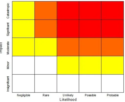
Figure 2.1- Risk Assessment Combining Likelihood and Impact
The chart above is one example of a simple risk analysis. The combination of likelihood and impact are merged by crossing each other, thus giving a score, based upon the square intersected. For example, if the likelihood was unlikely and the impact was moderate then we would obtain an orange score, which is considered a high risk score.
2.7 Conclusion
This chapter has presented the outcomes of the literature review that was conducted. Journals and theses were found in the search that related to all the issues addressed. Background information to this project was found that will assist in understanding how to complete the remaining sections of this dissertation.
Major findings in this chapter included a critical analysis of modern car navigation systems, the sources and collection of road network data, a review of GPS simulation and GPS NMEA data plus methods of
Chapter 3
3.1 Introduction
This chapter will outline the methods on how this project will be
conducted and completed. This is necessary because a record of how this project is to be completed is required by means of informing the reader of the account of the main occurrences that led to the
successful completion of this project. The main problem that will be addressed in this chapter is resolving a solution to the method of completing this project.
The aim of this chapter is to explain how all the methods needed to complete this project will occur, from the testing to the analysis and recommendations stage.
3.2 Overview of Project Method
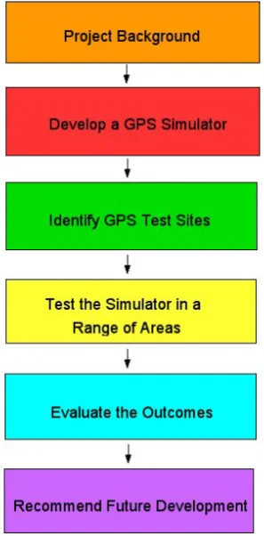
Figure 3.1- Project Method
3.2.1 Project Background
Background knowledge of the different aspects of the project has been covered, ranging from the GPS satellite navigation systems to
simulation concepts. This stage of the project is covered in the second chapter of this dissertation.
3.2.2 Develop a GPS Simulator
forward here is unsuccessful, assistance may be required to facilitate the function of this proposed simulator.
There is a range of different NMEA generator/streaming software packages available, depending on the specific purpose of the simulation. Putting it all together into one single system will require some amount of time in testing the different stages separately and then bringing it all together to form one complete simulator. Testing will also give us an evaluation of its overall suitability for this project. The
purchasing of needed equipment like base maps and a GPS satellite navigation system will be required during this stage.
3.2.3 Identify GPS Test Sites
This stage involves identifying some specific roads that may have erroneous data for the purpose of testing the GPS receiver. As discussed in the Literature review, there are two different types of errors we are seeking to test- missing data pertaining to existing roads and surveyed roads that are not operational as a road (excess data). We will focus on finding data related to roads that are familiar and if necessary, resort to roads that are unfamiliar. For this purpose, most of these roads will exist in the South-east Queensland and Northern New South Wales regions. Once these sites are chosen, coordinate data for these roads will be found using Google Earth or by capturing NMEA data whilst driving these roads. Different roads will be chosen
depending on the type of errors that are present and the type of road (urban streets or rural highways). If we simulate a road using
3.2.4 Test the Simulator in a Range of Areas
These sites will be tested by our simulator through the transmission of NMEA sentences from the computer to the GPS receiver. The sites will contain erroneous data and will either encounter navigation problems (due to missing data) or smooth navigation along non-existent roads. The reaction of the navigation system will be noted for further analysis. Preparation of data for simulation will be the collection of NMEA text files with captured data or the coordinates of roads obtained using Google Earth. Successful simulation of a road that does not exist will be tested and situations that would occur in the real world (like the choice of driving a different road) will be evaluated. When the chosen roads are tested using the simulator, their suitability will be assessed. If for some reason a road is unsuitable then a new road will be chosen and the steps to be taken (like data capture) will be completed.
3.2.5 Evaluate the Outcomes
The results will be analysed and an assessment of the quality of road network data used in satellite navigation will begin. Results will be kept separate, depending on the type of quality issues being analysed. The results will be reported based on the erroneous navigation achieved during simulation and an assessment of these effects on the safety of drivers through driver surveys and the accompanied risk assessments. The simulator will be assessed at this stage to determine its overall effectiveness in giving us reliable information.
3.2.6 Recommend Future Development
3.3 Initial Satellite Navigation System Testing
Even though the overall accuracy of the GPS receiver is not part of any critical analysis in this project, the point-positioning accuracy has to be reviewed because of the snapping function in the CoPilot 7 software. The snapping function onboard satellite navigation software needs to be investigated by finding out the accuracy of the on-board GPS receiver and finding the approximate offset distance (perpendicular distance between a driver and a road) required for snapping to cease functioning. This situation can occur where a driver travels along a road that is not stored in the on-board maps in the satellite navigation
system and this road exists parallel to a known road (say a neighbouring street that is parallel to an arterial road). Snapping involves the automatic movement of the navigation onto that
neighbouring road. The CoPilot 7 software will ‘snap’ a driver onto a road that exists in the on-board maps, thus would affect the accuracy of a navigated path presented by the satellite navigation system.
To test the accuracy of the on-board GPS receiver, testing the position over known marks with coordinates will need to be made. Data related to some Permanent Marks or State Survey Marks will need to be found and the coordinates of these marks will be used to test the GPS by recording its position whilst sitting over these marks.
snapping affects the navigation along an unknown road and its safety on drivers.
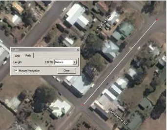
Figure 3.2 – Ruler Function in Google Earth
(Source: Google Earth, 2008)
3.4 Development of GPS Simulator
The concept of developing this simulator was aimed at using some of the latest technology available today. Utilising wireless technology in the development stage was our initial aim and the vision of being able to use Bluetooth technology to transmit GPS data to a satellite
navigation system was optimistic.
generator program). Trip distances and navigation were two other available options that were utilised using this module. The use of this basic NMEA generator program (called NMEA Generator) had
[image:39.595.152.442.172.395.2]restrictions that would make it difficult for us to continue this
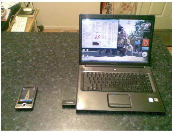
Figure 3.3 – GPS Simulator
project effectively. A different program was found that could record NMEA data from a GPS receiver and replay this data through a designated COM port. Both of these events were important
achievements in the development of the simulator. This new program is called GPS-NMEA Monitor and it recorded NMEA data into a text file. This replay of NMEA data was similar to the NMEA generator, such that the data was transmitted through a Bluetooth COM port.
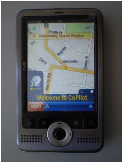
connection. After some research into the different brands of PDA computers that are capable of receiving NMEA Bluetooth signals it was decided that the best option was to purchase an Asus A696 (with CoPilot 7 navigation software and Navteq maps). After some initial testing this simulator became a very substantial development for this project.
Figure 3.4 – ASUS A696 PDA Satellite Navigation System
3.5 Collection of NMEA Data
The GPS simulator was specifically developed to test roads with low quality road network data. This was to be achieved so that the analysis of the satellite navigation system’s reaction to low quality road network data could be repeated without the need to drive the roads repetitively. Although these roads need to be driven to collect NMEA data, this would only need to be completed once. The coordinates of some other roads will need to be collected using Google Earth.
actual collection of this data is to be conducted using two different methods. Each individual section of road that will be tested will determine the method of data collection. The two methods are:
Direct collection of NMEA data using a GPS receiver
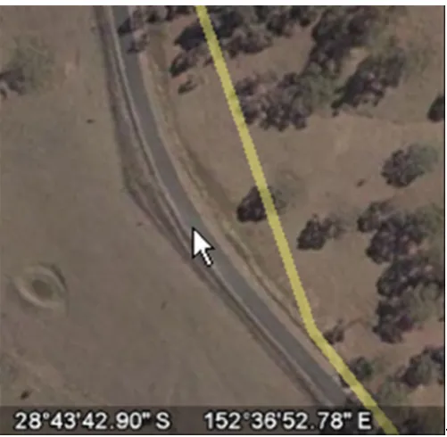
Indirect collection of coordinate data using Google Earth
-Figure 3.5 – Cursor on Road in Google Earth with Coordinates Displayed at Bottom of Screen.
(Source: Google Earth, 2008)
The other option for recording NMEA data involves driving the roads to be tested and collect this data using a GPS receiver. This receiver is connected to a laptop and communicates with the NMEA data
collection software program through a USB COM port. The GPS
receiver used for this option of data collection is the Magellan Explorist XL. This GPS receiver connects to the laptop using a USB cable and all NMEA data is streamed into the program and recorded in a text file (saved as .nmea).
[image:42.595.171.422.69.314.2]3.6 Simulator Setup for NMEA Data Transfer
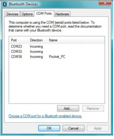
[image:43.595.200.396.325.565.2]The replay of the NMEA data will use the same program utilised to collect this data, that is, GPS-NMEA monitor. Before this program is used for NMEA data replay, the Bluetooth USB adaptor needs to be setup. This involves setting up the Bluetooth adaptor to talk to a specific Bluetooth-enabled device using a COM port. To set a COM port for a specific device, the software provided with the device gives the option to add a device as a COM port to another Bluetooth-enabled device. Once the device is scanned, the software assigns a COM port number for exclusive communication between the computer and the assigned Bluetooth device.
Figure 3.6 – Bluetooth COM Ports
When a COM port is assigned to the satellite navigation system, COM ports need to be assigned on the PDA. This will ensure direct
Once the simulator is ready, a .nmea file is to be assigned in the GPS-NMEA monitor program. The COM port settings that were set in the computer for NMEA data transfer to the PDA also need to be made in the options menu. Once the NMEA file is opened, transfer of the data is ready to begin. On the bottom of the screen is the play button; a simple press of this button will begin NMEA data transmission.
Figure 3.7 – COM Port Options in GPS-NMEA Monitor
To ensure successful transmission of data the satellite-navigation system would be displaying the dynamic effects of this data through the movement of the vehicle down a recorded path. To ensure navigation, a destination must be set. The destination must be set so that snapping onto roads does occur and that a reasonable assessment of the
driver’s safety can be examined and determined. If the simulation does not occur the most likely problem is an error in the settings, either in the computer program, the COM port assignments or the CoPilot 7 settings. All of these settings must be correct for simulation to occur.
3.7 Monitor Satellite Navigation System for Navigation Errors on
Missing Roads
This stage of the method entails identifying errors present in the navigation made by the car navigation system. The nature of these roads is known- therefore the identification of any navigation as incorrect will be made easier due to known information about the roads. These errors will be identified and used in the next stage of this project, the survey of drivers.
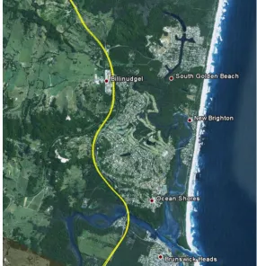
3.7.1 Missing Roads- Pacific Highway, Brunswick Heads, NSW
[image:45.595.153.440.431.728.2]This first example of testing a road with missing data is the new deviation of the Pacific Highway, extending from Yelgun to Brunswick Heads, approximately 45 kilometres north of Ballina, NSW. This new section of the Pacific Highway was constructed to improve traffic flows through this area, by means of bypassing towns like Billinudgel and Ocean Shores. This new road is approximately 8.6 kilometres in length.
Figure 3.9 – Pacific Highway, Brunswick Heads
Although this new section of the highway is a new road, it follows a similar route to the old highway and we would expect the snapping function to be active during the testing of this road. But the new road does deviate in specific sections which would allow the snapping function to be tested and evaluated. The old road also had a roundabout on the highway at the Brunswick Heads turnoff which remains in the maps that are loaded into the satellite navigation system.
Analysis of this road would give us a suitable perception of the effects of low quality road network data on a major highway. This highway has improved driver safety but the effects of low quality road network data can be a confusing and potentially dangerous situation for drivers who do not travel this road regularly.
3.7.2 Missing Roads- Elevation & Aspects on Lennox, Lennox Head, NSW
The second example of roads with missing data are two new
subdivisions that exist approximately half a kilometre apart on North Creek Road, south of Lennox Head, NSW. These subdivisions finished construction in 2007/2008 and are only a few minutes drive to local beaches and neighbouring towns like Lennox Head and Ballina.
These new roads will be tested to give us an assessment of the effects of low quality road network data in urban areas, where pedestrian activity would be high. The expected reaction of the satellite navigation system to these roads is expected to either snap onto neighbouring streets or navigate into an area with no data.
3.7.3 Missing Roads- Hogbin Drive, Coffs Harbour, NSW
The third example of testing roads with missing data is the new
areas south of Coffs Harbour like Sawtell and Toormina better access to areas north of the city centre. It reduces travel times through
bypassing the congested section of the Pacific Highway which goes through the centre of the town.
Construction of this new road was finished in February 2008 and sections of the road have been constructed in bushland away from existing roads. This new road will give an opportunity to analyse a major urban road and how safe it would be to travel this type of road without appropriate navigation. The expectations of the navigation of this road are for some snapping to occur onto roads that exist parallel on both sides plus some movement in areas with no road network data.
3.8 Monitor Satellite Navigation System for Navigation Errors on
Excessive Data Roads
The method used to monitor navigation errors in these test sites will be no different to the method used in the test sites used in missing road data monitoring. These test sites however are based on roads that either non-existent or where access along these roads are restricted due to physical monuments in the real world.
3.8.1 Excessive Data Roads- Acacia Street, Killarney, QLD
Figure 3.10 – Acacia Street, Killarney
(Source: Google Earth, 2008)
[image:48.595.165.432.71.344.2]When a driver is approaching Acacia Street whilst on Ivy Street, there is no road where the satellite navigation system would tell the driver to turn right. A driver approaching either end of Acacia Street would encounter different problems with respect to the nature of the road.
3.8.2 Excessive Data Roads- First Avenue, Lismore, NSW
The second example is a road that has been closed from access due to the installation of a concrete drain even though the on-board maps in the satellite navigation system suggest that the road remains
accessible. First Avenue in Lismore, NSW was originally surveyed and connected to the main arterial road that exists through Lismore, the Bruxner Highway. But this thoroughfare is closed to through traffic and is today only an access road for the houses on the north side of the drain. Traffic lights were installed in 2005 to connect Diadem Street with the Highway.
Figure 3.12 – First Avenue, Lismore
(Source: Google Maps <http://maps.google.com.au>, 2008)
Figure 3.13- Entrance to First Avenue, Lismore
3.8.3 Excessive Data Roads- Loveday Road, Cooby Dam, QLD
The final example is the testing of a road that was originally surveyed in an area where one of the major water-supply dams for Toowoomba, QLD now exists. Loveday Road is approximately nineteen (19)
kilometres north of Toowoomba and exists along the southern edge of Cooby Dam with approximately half a kilometre of the road passing through the dam (if the dam was at full capacity).
Figure 3.14 – Loveday Road through Cooby Dam
(Source: Google Maps <http://maps.google.com.au>, 2008)
Figure 3.15- Loveday Road through Boat Ramp Sign
3.9 Survey of Drivers
[image:51.595.131.466.396.649.2]finalised so that a suitable survey of drivers will eventuate. This survey will consist of the replay of the subject roads to a sample of everyday drivers, using the simulator. A series of questions will be presented to the drivers as they observe the actions of the satellite navigation system. With some given knowledge of the roads, they will answer the questions as a first reaction answer.
Certain situations in the driver’s environment will be told to them during the simulation replay. This will influence the decisions they make, based on their own driving experience and level of driving they
regularly perform. The questions developed and used for this survey is contained in Appendix C.
3.10 Risk Assessment
When a sufficient number of persons have participated in the driver survey, all the results will be combined to form a risk assessment for each of the sample roads. When a driver participates in the driver survey, they will be asked to rate the road with respect to the potential dangers the navigations pose to drivers. Each surveyed driver will rate the road in terms of:
Probability of a Car Accident
Potential Consequence of a Car Accident
3.11 Formulation of Further Recommendations
Improvements and recommendations for changes in the management and modification of road network data will be completed when the testing and the analysis stages have been completed. The full report of all recommendations is completed in Chapter five of this dissertation. The recommendations will address issues concerning the manipulation of road network data and procedures to change this data when roads are closed or simply do not exist in an area.
3.12 Conclusion
This chapter has outlined the methods that will be employed in the successful completion of this project. A simulator will be developed to aid in testing roads with low quality road network data, six (6) different roads will be tested using the developed simulator and their impact on road users will be evaluated using survey driver testing and risk
assessments.
The literature review has assisted in developing a suitable project method. However, some stages like the development of the simulator and the driver surveys will be further developed as this project
Chapter 4
4.1 Introduction
This chapter will present the results related to all the testing which occurred during this project. This testing included the identification of navigation errors from the satellite navigation system and the driver reaction testing. These results will be presented to demonstrate the potential errors that can arise in satellite navigation and how drivers would react in certain situations. This chapter will further assist the direction of the discussions and recommendations chapter. Problems that will be addressed in this chapter are the nature of the navigation errors and the most likely driver reactions to the examples used in this project.
The aim of this chapter is to present the navigation errors that occurred during the simulation stage and the driver reaction test results that will indicate how a driver would react in these situations.
The simulator will operate and drive along the navigation paths and along the routes. Any variations between the navigation paths and the physical real-world roads will be identified. A driver reaction survey will be developed and the simulator will replay these navigations to a selection of drivers and their reactions to certain navigations will be noted as part of the risk assessments.
4.2 Satellite Navigation System Testing
The initial testing of the ASUS A696 satellite navigation system was to gain a better understanding of the capabilities of the system. The testing of certain functions would show how the functions would affect the results of this research. Testing of this data has brought some more background information and has provided some solutions to the
capabilities and accuracies of the satellite navigation system.
quality of the GPS receiver in the satellite navigation system is acceptable. Measurements were taken using control marks (State Survey Marks) around Ballina, NSW. The control marks data were obtained from Deposited Plans and SCIMS (Survey Control Information Management System) data.
The control data for these marks are based on the GDA94 datum, which is slightly different to the measurements made by the GPS receiver, which will have data based on the WGS84 datum. The difference between these two data in 2008 would represent an
ellipsoidal distance of about one metre. This difference exists because WGS84 datum is a dynamic datum; whilst GDA94 is a static datum (it represents the value of ITRF datum in 1994). The main reason why there are static and dynamic data is due to plate tectonics, and the relative movements of different plates around the world.
The results can be seen as comparable to each other, as this distance is minimal compared to the accuracy of the GPS receivers. The results for these tests were taken using two separate GPS receivers – the ASUS A696 and the Magellan Explorist XL.
Table 4.1 – Results of Point Accuracy
SSM78477 ASUS: 28˚51’38.29” S; 153˚32’11.91” E
Magellan: 28˚51’38.34” S; 153˚32’11.94” E
SSM69195 ASUS: 28˚51’41.49” S; 153˚35’39.24” E
Magellan: 28˚51’41.47” S; 153˚35’39.23” E
SSM64149 ASUS: 28˚51’56.56” S; 153˚33’31.50” E
Figure 4.1 – Location of State Survey Marks Used for Testing
(Source: Google Earth, 2008)
These results show good consistency between the receivers and the control mark data. Distances between any coordinates were less than 1.8 metres between the receivers and less than 2.8 metres between the receivers (on WGS84) and the GDA94 control data. The GPS receiver is therefore dependable for the accuracy needed for the experiments conducted. The position given by the GPS receiver would be sufficiently accurate, even if the situation arises where the maps do not contain roads when the GPS receiver is indicating a path through its position fix.
Experiments were conducted to test the effects of the snapping function in CoPilot 7. These experiments were conducted using the simulator (and the NMEA generator program). Offset distances were inserted into the program, in steps of fifty (50) metres from a straight section of road.
The section of road that was used to conduct these experiments were a straight section of the New England Highway at Missen Flat,
along the western side of the highway. In term of the results, there were no problems with snapping onto the road within 200 metres offset. When any distance above 200 metres were tested (first interval was 225 metres) there were some problems with snapping. Some experiments snapped onto the roads but some repeated experiments failed to achieve any snapping. A distance of 250 metres was tested and there were no snapping at this offset when several experiments were conducted. With this data gathered, we would suggest that
snapping would definitely cease functioning somewhere between 230 – 250 metres offset from any road.
4.3 Suitability of GPS Simulator
After the testing has been completed it would be proper to assess the suitability of the simulator. In terms of its overall suitability it proved to be quite vigorous in the testing stage and the overall operation was excellent.
The section of the testing that tested the roads with missing data was very effective, as it simply replayed real-world NMEA data of these roads. To achieve this using a simple program and then transmit it through a Bluetooth COM port now opens up opportunities for similar testing using this technology in other applications. The GPS-NMEA monitor software allowed recording of NMEA data plus the replay of this same data through a designated COM port. Problems do exist with the simulation if there is too much distance between the computer and the satellite navigation system due to the limitations of Bluetooth.