Abstract: The accuracy of position estimation is indicated by Geometrical Dilution of Precision (GDOP) which depends on geometry of visible satellite with respect to receiver. In this paper, GDOP is calculated by estimating the receiver position using Firefly Algorithm (FA). This method offers less computational complexity as compared to complicated matrix inversion method which is a time and power consuming process. The simulation outcomes indicate that FA does well in terms of convergence time and also accuracy of estimated position. The mean value of position error obtained using FA in x-coordinate is 49.99m, y-coordinate is 131.99m and z-coordinate is 41.79m. FA provides maximum GDOP value of 2.183 and minimum of 1.244. For 24Hours of GPS data, FA has taken computation time of 50.38sec to converge by taking an interval of 2Hours data.
Index Terms: Firefly algorithm, GDOP, Kalman filter, position accuracy.
I. INTRODUCTION
The GPS is an satellite based navigation system of US advanced from the Department of Defense (DoD) is an all-weather system [1]. Over 24 hours a day, GPS deliver a three dimensional position, velocity, and time by transmitting two signal frequencies of 1575.24 MHz and 1227.6 MHz in L-band continuously anywhere on the globe. GPS is peferred mainly due to its fully operational and highest global coverage i.e., 8 to 14 SVs visibility between
75
0 Latitude, eventhough there are so many available constellations for satellites are there in world. It is used oftenly in defense and civil aviation sectors. GDOP factor analysis [2] is mostly dependent on GPS position accuracy.The GPS receiver’s position accuracy is influenced by the geometrical orientation of satellites when compared with receiver position. The study of GPS position error is discussed using Firefly optimization technique and then GDOP is found in this paper. GDOP is based upon spatial distribution of satellite vehicles and number of visible satellites over a given geographical location. Better values of GDOP [3-5] indicate more number of satellites are used for position estimation. Firefly Algorithm is used to estimate the position of receiver as it is required to calculate the GDOP factor.
The methods used for position estimation are generally Least Squares (LS) method for static positioning and Kalman filter (KF) method, extended versions of kF for dynamic positioning. In all of these methods, the initial position of receiver is assumed to be zero and then iteratively updated the
Revised Manuscript Received on May 28, 2019.
First Author name, G Sasibhusana Rao, Dept. of ECE, AU College of Engg.(A), Visakhapatnam, India.
Second Author name, Lavanya Bagadi, Dept. of ECE, MVGR College of Engg.(A), Vizianagaram, India.
position based on the method adopted to reach nearby to the surveyed location. Whereas in all optimization techniques the initial guess is random based still it can be seen that FA technique performs better not only for position estimation but also for GDOP calculation. The GDOP is calculated simply by knowing the designed matrix which is the difference between satellite coordinates and receiver coordinates are the resultant coordinates obtained after the application of FA divided by pseudorange equation given in Eq.(2).
GDOP calculation can be done in two ways that is either by optimal satellite selection [6] method means choosing best four or five satellite combination out of all available satellites, or by considering all visible satellites into account as minimum of four satellites is necessary condition criteria for GPS. In this paper the second approach is being taken into account while calculating GDOP and it is shown that by considering all visible satellites [7] at each epoch the value of GDOP is better rather than optimal selection criteria. In section 2, position error analysis using Firefly Algorithm along with the fitness function is considered. GDOP calculation is presented in section 3. In Section 4, results and discussion is carried out followed by conclusions in section 5.
II. FIREFLY ALGORITHM
The fitness/objective function measured for calculation using Firefly Algorithm technique is
CR OR
f
P
P
O
=
−
(1)Where
P
OR is the Observed Pseudorange andP
CR isCalculated Pseudorange. Then
O
f is calculated till the variation between Observed Pseudorange and Calculated Pseudorange reduces to minimum or zero value.2 2
2
)
(
)
(
)
(
sx rx sy ry sz rzCR
x
u
y
u
z
u
P
=
−
+
−
+
−
(2)Where
x
sx,
y
sy,
z
sz are satellite coordinates, andrz ry rx
u
u
u
,
,
are receiver coordinates.Firefly Algorithm (FA) was established first by Yang X.S in 2008 [8, 9] that is built on flashing activity of fireflies. The generation of initial population is random based. The current population is checked for fitness value (objective function value) to accept the solution. The iteration is stopped after attainment of best results or completion of maximum number of generations. FA is tuned to speed up the convergence as iterations continue by controlling the parameters randomness [10].
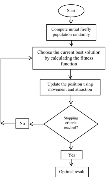
The steps involved in implementing FA are given below [11].
Firefly Algorithm Based GDOP Estimation
for GPS Applications
Step 1: Initialize firefly parameters as shown in Table 1. Step 2: Create initial firefly population randomly for the given parameters using unifrnd function in matlab.
Step 3: Choose the current best solution by calculating the fitness function.
Step 4: Update the firefly position using movement and attraction considering the following equations.
2 0 d
e
=
− (3) t t t i t j d t i ti
x
x
x
x
ije
− + + = − + ) ( 2 1 (4)
Where
tis controlling parameter of step size, whlie
tis a vector of guassian or other distribution.Step 5: Terminate, if stopping criteria is fulfilled.
[image:2.595.302.549.120.339.2]Table I provides FA parameters used for implementation purpose [12].
Fig. 1 presents the flowchart of FA.
III. GEOMETRICAL DILUTION OF PRECISION (GDOP)
The GDOP [4,13] decribes the positioning accuracy from the geometry of visible satellites to the receiver [14].
The GDOP factor is measured using Eq. (5)
GDOP
=
trace
(
A
TA
)
−1 (5) Here, A is the designed matrix achieved from below Eq. (6). = 1 . . . . . . . . 1 1 3 2 1 23 22 21 13 12 11 m m m r r r r r r r r r
A (6)
where CRi rxi sx i P u x
r1 ( )
− − = , CRi ryi sy i P u y
r2 ( )
− − = , CRi rzi sz i P u z
r3 ( )
− − = , ,.... 2 , 1 m
i= for all visible satellites in each epoch.
Where
x
sx,
y
sy,
z
sz are satellite coordinates,rz ry rx
u
u
u
,
,
are receiver coordinates andP
CRi is calculatedpseudorange.
The receiver coordinates
u
rx,
u
ry,
u
rz are the estimatedreceiver output positions obtained from Firefly Algorithm and
CRi
P
can be obtained using Eq. (2).The approach is based on selecting all visible satellites at each epoch for estimation of receiver position using Firefly Algorithm [9]. For GDOP calculation, with increase in the number of satellites the factor of GDOP value gets decreased specifies that selection of all the satellites for GDOP results in good accuracy.
The value of DOP parameters is assessed rendering to the Table II [5].
Table II. Ratings of DOP Values
IV. RESULTS AND DISCUSSION
Firefly Algorithm is applied to estimate the GPS receiver position and position error in 3 dimensions in this paper. For implementing this algorithm, the necessary input data is collected from the real time dual frequency GPS receiver on 7th March 2016 which is positioned at Electronics and Communication Engineering Department, Andhra University, Visakhapatnam, Latitude 17.730N/Longitude 83.310E and the receiver error position
analysis is taken for 24Hours period of duration.
[image:2.595.41.275.275.364.2]Surveyed location
Table I. FA parameters used in algorithm
Parameter Definition value np MIt α β γ αd Fireflies Number Number of max iterations Mutation Coefficient Base Value of Attraction Coefficient Absorption Coefficient of Light Damping Ratio of Mutation Coefficient 20 350 0.2 2 1 0.98 DOP Value Ratings
<1 Ideal 1-2 Excellent 2-5 Good 5-10 moderate 10-20 Fair
>20 Poor
Fig.1 Flowchart of FA
Stopping criteria reached?
Compute initial firefly population randomly
Start
Choose the current best solution by calculating the fitness
function
Update the position using movement and attraction
[image:2.595.38.254.403.765.2]coordinates are (xr=706970.90m, yr=6035941.02m, zr=1930009.51m). The receiver captures the data in Receiver Independent Exchange (RINEX) format which basically involves 2 files namely: i) observation data and ii) navigation data files. The observation file contains all the satellites visible to attain the pseudoranges on a particular epoch of time after adjusting for satellite clock error. The existing satellite position in 3D is calculated from the navigation file that comprises of 22 ephemeris data within it. The receiver then calculates the comparative positions among the satellite and receiver depending on received statistics for the two files. For GDOP estimation it is necessary to know receiver position in prior. The simulation results discussed are carried out using Matlab 2016a.
Table III shows the receiver position estimates and the deviation from surveyed position as error using FA method. The table shows the inaccuracy in the respective coordinates of the GPS receiver position along with the GDOP. A GDOP value lying between 1 to 2 indicates the accuracy of used FA method. The mean values of position error obtained using FA in x, y and z-coordinate is 49.99m, 131.99m and 41.79m respectively.
Fig.2 X- coordinate Rx position error using FA method (averaged for every 2 hours)
Fig. 2 shows variation in X- coordinate error for the entire observation period of 24Hrs. The receiver position in this coordinate is deviated a maximum of 54 m and minimum of 46 m from its true value.
Fig. 3 shows variation in Y- coordinate error for the entire observation period of 24Hrs. The receiver position in this coordinate is deviated a maximum of 136 m and minimum of 128 m from its true value.
Fig.3 Y- coordinate Rx position error using FA method (averaged for every 2 hours)
Table III. Receiver position estimation and GDOP using Firefly Algorithm method Receiver position [meters] Error in receiver position [meters]
GDOP Time
[Hrs] Xr Yr Zr EXr EYr EZr
02.00 706922.97 6035806.30 1929964.21 47.93834 134.7158 45.36232 1.622
04.00 706921.09 6035804.22 1929963.41 49.81224 130.8506 46.16470 1.591
06.00 706912.33 6035810.09 1929966.61 47.88877 130.9277 31.47469 1.581
08.00 706916.51 6035811.01 1929966.33 52.10526 130.0100 43.24364 1.412
10.00 706922.01 6035805.33 1929967.42 48.89236 135.6849 42.15711 1.487
12.00 706922.25 6035807.61 1929960.15 48.65656 133.4049 45.97469 1.362
14.00 706918.61 6035806.89 1929964.14 52.29074 134.1234 45.43483 1.264
16.00 706917.69 6035807.90 1929956.65 53.21291 133.1206 38.48994 1.180
18.00 706916.08 6035812.43 1929960.15 50.28349 128.5886 42.13732 1.211
20.00 706918.50 6035807.59 1929958.97 52.40445 133.4324 42.32097 1.421
22.00 706923.29 6035812.15 1929960.81 49.94254 128.8685 41.22457 1.156
[image:3.595.119.476.246.448.2] [image:3.595.326.556.498.692.2] [image:3.595.73.301.570.751.2]Fig.4 Z- coordinate Rx position error using FA method (averaged for every 2 hours)
Fig.4 shows variation in Z- coordinate error for the entire observation period of 24Hrs. The receiver position in this coordinate is deviated, maximum of 46 m and minimum of 31m from its true value.
Fig.5 FA Convergence graph
Fig. 5 displays the deviation of best cost for FA with increase in iterations number i.e., FA has taken maximum of 350 iterations to converge to the desired result.
Fig. 6 show the total availability of visible satellites in all the epochs considered.
It is observed that a total of 14 visible satellites appears at epoch time 486030 seconds of week(sow), which corresponds to maximum number and a total number of 8 visible satellites appears at epoch time 496875sow which corresponds to minimum value.
Fig.6 Total availability of visible satellites with epoch time
Fig.7 show the variation of GDOP value with increase in epoch time and it is observed that a maximum GDOP value of 2.183 appears at epoch number 451380sow and a minimum GDOP value of 1.244 appears at 487500sow. The occurrence of GDOP value between 1 to 3 from Fig. (7) show that the accuracy achieved by application of FA method to GPS receiver position is better for GDOP calculation.
Fig.7 Variation of GDOP value with epoch time
The variations of GDOP value owing to satellite distribution is presented in Fig. 8 and 9.
Fig. 8 and 9 displays the sky plots for the epochs having minimum and maximum GDOP values with SVPRNs displayed and also is evident that minimum GDOP results in wide spatial distribution of satellites while they are nearby for maximum GDOP [15].
[image:4.595.71.279.54.227.2] [image:4.595.330.541.56.239.2] [image:4.595.72.282.339.502.2]Fig 8. Sky plot of minimum GDOP Fig 9. Sky plot of maximum GDOP
V. CONCLUSIONS
The receiver position derived from FA is accurate as GDOP value lies between 1 and 2. To reduce the complexity and computational burden involved with matrix multiplication method as the calculation of GDOP with this method is time consuming, FA provides a better solution. The receiver position error in all the three coordinates are in the order of tens of meters. From the results it is found that, the maximum errors are observed to be 54 m, 136 m and 46 m and minimum errors to be 46m, 128m and 31m in X, Y and Zcoordinates. For entire 24Hrs GPS data distributed as 2Hrs data interval the computation time taken is 50.38sec for convergence of FA. The convergence time shows the speed of FA to compute GDOP value. The accuracy provided by FA convinces to use this method in civil and defense sectors.
REFERENCES
1. G S Rao: Global Navigation Satellite Systems, McGraw Hill Education Private limited, ISBN (13): 978-0- 07-070029-1, (2010). 2. Nie Z, Y Gao, Z. Wang, and S. Ji.: A new method for satellite selection with controllable weighted PDOP threshold, Survey Review, Vol. 49, No.355, 2017, pp.285-29,.
3. Y Teng and J Wang.: New Characteristics of Geometric Dilution of Precision (GDOP) for Multi-GNSS Constellations, Journal of Navigation, vol. 67, No.6, 2014, pp.1018-1028.
4. Sharp I, Kegen Y, Guo YJ.: GDOP analysis for positioning system design, IEEE Transactions on Vehicular Technology, vol.58, No.7, 2009, pp.371–3382.
5. https://en.wikipedia.org/wiki/Dilution_of_precision_(navigation), 2013.
6. Miaoyan Zhang, Jun Zhang, Yong Qin.: Satellite selection for multi-constellation. Position, Location and Navigation Symposium, IEEE/ION, 2008 , pp. 5–8.
7. Miaoyan Zhang, Jun Zhang.: A fast satellite selection algorithm: beyond four satellites. IEEE Journal of Selected Topics in Signal Processing, (2009), 3(5), pp.740–747. PubMed PMID: WOS:000271020000002.
8. Yang, X S.: Firefly Algorithm, Stochastic Test Functions and Design Optimization. Int. J. Bio-Inspired Computation, Vol. 2, No. 2, 2010, pp.78-84.
9. Yang, X S.: Nature-Inspired Metaheuristic Algorithms. Luniver Press, Beckinton, UK, 2nd edition, 2010, pp 79-90.
10. Yang, X-S.: Firefly algorithms for multimodal optimization. In Watanabe O, Zeugmann T, (eds.) Stochastic algorithms:
foundations and applications, SAGA 2009, LNCS, vol. 5792, pp. 169–178. Springer-Verlag (2009).
11. Eiben AE, Smith JE.: Introduction to evolutionary computing. Springer, Berlin Heidelberg, New York, (2003).
12. Osman I.H., Kelly J.P: Metaheuristics:An overview. In Osman I.H., KellyJ.P. eds. Metaheuristics:Theory and Applications, Kluwer Acad. Publisher (1996).
13. Chaffee J, Abel J.:GDOP and the cramer-rao bound. Position Location and Navigation Symposium, IEEE, 1994, pp11–15. 14. Doong SH.: A closed-form formula for GPS GDOP computation.
GPS Solution, vol. 13, No.3, pp.183–190, ( 2009), PubMed PMID: WOS:000267662000003.
15. G.S.Rao, B. Lavanya, N. Ashok Kumar: Chptr. 1, Satellite Horizon Effects on Temporal GPS Receiver Position Accuracy over Coastal Area of South India, America Springer Nature, Inc, 2019.
AUTHORSPROFILE
Dr.G.Sasibhushana Rao received his B.E. Degree in Electronics and Communication Engineering from Andhra University, Andhra Pradesh, India, and M. Tech. Degree in Electronics and Communication Engineering from JNTU University, Andhra Pradesh, India. He obtained his Ph.D. degree in Global Positioning System from the Osmania University, Andhra Pradesh, India. He is currently working as Professor in Department of Electronics and Communication Engineering, Andhra University. He is the author of about 517 scientific publications in journals, international and National conferences. His research interests include Global Positioning Systems, Wireless communication, Signal Processing. He is an author of the 4 text books ‘‘Global Navigation Satellite System’’ (published by McGraw-Hill Education), ‘‘Mobile Cellular Communication’’ (Published by Pearson Education), ‘‘Electromagnetic Filed Theory and Transmission Lines’’ (Published by John Wiley & Sons), ‘‘Microwave and Radar Engineering’’ (Published by Pearson Education).