International Journal of Innovative Technology and Exploring Engineering (IJITEE) ISSN: 2278-3075, Volume-8 Issue-8S2, June 2019
Abstract: Background: For image contents filmed by digital equipment, the object is recognized and photographed through the light reflected against it. If there is not any contamination in the reflected light, we can get image contents as we intended. However, if the light reflected against the object is contaminated, the degraded image contents are obtained. There is less contamination in the light reflected against objects in most interior spaces. On the other hand, most of image contents photographed during leisure sports activities or taken by a camera mounted on a drone are taken in an outdoor environment, and for such image contents photographed in an outdoor environment, the light reflected against the object is very likely to be contaminated. Therefore, this paper intends to solve the degradation problem of image contents through restoration of degraded image contents.Methods: This paper intends to solve the degradation problem of image contents through restoration of degraded image contents. In order to restore degraded images, an adaptive dark channel technique is proposed that generates edge map using standard deviation, and preserves edge with a weighting map using weight function. As adaptive dark channel preserves boundary and estimates the amount of light transmission, the naturally restored images can be obtained. As a result of conducting experiments involving aerial and underwater images, in can be confirmed that the degraded image contents are efficiently restored using the proposed method.Findings: This paper aims to figure out degree of degradation and to efficiently restore the degraded image contents degraded by particles in the atmosphere, and to this end, estimates atmospheric light and the amount of light transmission and restores images. In addition, this paper estimates distance from a single image.Applications: Image processing technique for restoring images proposed in this study can also be used for white balancing calculation, and the amount of light transmission can be used to estimate depth information of a single image. It is also possible to create high-quality image contents that can express a richer color after restoring the degraded image.
Index Terms: Weight Function, Degraded Image, Adaptive Dark Channel Technique, Global atmospheric light, Edge Map Computer visions.
I. INTRODUCTION
The development of digital devices such as general purpose digital camera and attachable subminiature camera make it easy for us to create image contents in our everyday life. It is no longer difficult to shoot image contents while enjoying a variety of leisure sports as well as under general situations. Furthermore, the development of drone industry has led to the active creation of image contents using cameras mounted
Revised Manuscript Received on May 23, 2019.
Tae-Eun Kim, Department of Multimedia, Namseoul University,
on drones. For image contents filmed by digital equipment, the object is recognized and photographed through the light reflected against it. If there is not any contamination in the reflected light, we can get image contents as we intended. However, if the light reflected against the object is contaminated, the degraded image contents are obtained. There is less contamination in the light reflected against objects in most interior spaces. On the other hand, most of image contents photographed during leisure sports activities or taken by a camera mounted on a drone are taken in an outdoor environment, and for such image contents photographed in an outdoor environment, the light reflected against the object is very likely to be contaminated. In an outdoor environment, the light reflected from an object is absorbed and scattered by atmospheric particles present in the atmosphere, and degrades image contents.1 In addition, the longer the distance between the photographer and the subject is, the more the particles in the atmosphere are distributed. On the contrary, the closer the distance between the photographer and the subject is, the less the particles in the atmosphere are distributed. Therefore, the degradation of image contents is proportional to the distance.2 Besides, the degradation of image contents is affected by weather conditions. Heavy snow, heavy rain, sea fog, yellow dust, fine dust and fog, which are generally classified into severe weather, are typical weather condition to degrade image conditions. Therefore, it is very likely that the image contents photographed in an outdoor environment would be degraded, which is proportional to the distance between the photographer and the subject. Additionally, in bad weather conditions such as fog, the image contents may be more degraded than under normal conditions even at the same distance. The existing papers (1~10) used various methods to estimate the distance between the photographer and the subject. Recently, a method of estimating the distance from a single image instead of multiple images has been proposed (2, 3, 4). In particular, DCP (dark channel prior)(2) estimates the amount of light transmission effectively from a single image using statistical method. However, soft matting is required to prevent halo effect of the restored images, which increases the complexity of algorithm. This paper aims to get a handle on the degree of degradation and to efficiently restore image contents degraded by particles in the atmosphere. To this end, the atmospheric light and the amount of light transmission are estimated to restore images. In addition, the distance from a single image is also estimated.
Development of a Method for Restoring
Deteriorated Digital Images
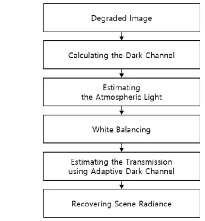
Fig. 1. The block diagram of proposed method The proposed method applied an adaptive dark channel technique to control halo effect efficiently, unlike dark channel which requires soft matting. A flow chart of the proposed method is shown in Figure 1. In connection with the composition of this paper, chapter 1 describes the proposed method, chapter 3 makes an analysis of the experimental environment and results, and finally, chapter 4 makes a conclusion.
II. THEPROPOSEDMETHOD
In the image contents photographed in an outdoor environment, the light reflected against the object is likely to be degraded by the atmospheric particles, which causes the quality of the filmed image contents to be degraded. In order to solve these problems, this paper proposes a method to restore the degraded image contents. Generally, according to the papers which have been studied in the past, computer vision and computer graphics define the degraded images as shown in Formula
1.
(2, 3, 4)=
(1)
In formula (1), I(x) means the degraded image. J(x) means a non-degraded image and is a target image to be obtained by the proposed method. t(x) means the amount of light transmission, and A means the atmospheric light, respectively. The position of pixels in each image is denoted by x. The degraded image contents are already-given information, and it is important to accurately estimate the amount of light transmission and atmospheric light in order to restore the degraded image contents.
(a)
(b)
(c)
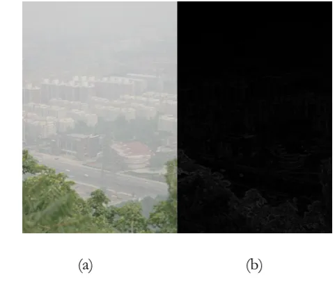
Fig. 2. Estimating the global atmospheric light and white balancing: (a) degraded image, (b) dark channel,
and (c) white balancing 2.1. Estimating the global atmospheric light
Global atmospheric light means light that is spread throughout the image. In order to estimate the global atmospheric light, a region that has little impact resulting from the object and is far
[image:2.595.48.260.48.276.2]International Journal of Innovative Technology and Exploring Engineering (IJITEE) ISSN: 2278-3075, Volume-8 Issue-8S2, June 2019
selected as the candidate region. DCP proposed a method of estimating the atmospheric light using dark channels in the input images, and dark channels are calculated using Formula (2).
(2)
denotes a dark channel, and denotes a degraded input image, where denotes channels, including red, green and blue channel. And denotes a local patch to get as a center pixel. denotes the location of pixels contained in the local patch to get as a center pixel.
The dark channel is a principle of calculating the smallest value out of RGB channels after calculating the smallest value in the local patch to get as a center pixel, which reflects the analysis results that the smallest value present in the dark channel is shadow, colorful object or dark object, when it comes to DCP. Therefore, when it comes to DCP, it is assumed that the high value contained in the dark channel is the degraded part, which is demonstrated by statistical analysis. As mentioned above, the degradation of image contents is physically proportional to the distance, so the highest value in the dark channel is the farthest part, and, for the global atmospheric light, DCP uses a method to select one of the highest pixels in the input image out of 0.1% of the brightest patch in the dark channel. The estimated atmospheric light will adjust the white balance on the degraded image using the following formula.
(3)
Where, is the estimated global atmospheric light, and the use of formula (3) will obtain the effect of adjusting white balance to remove the effect of the global atmospheric light from the degraded image .
(a) (b)
[image:3.595.314.545.50.247.2](c) (d)
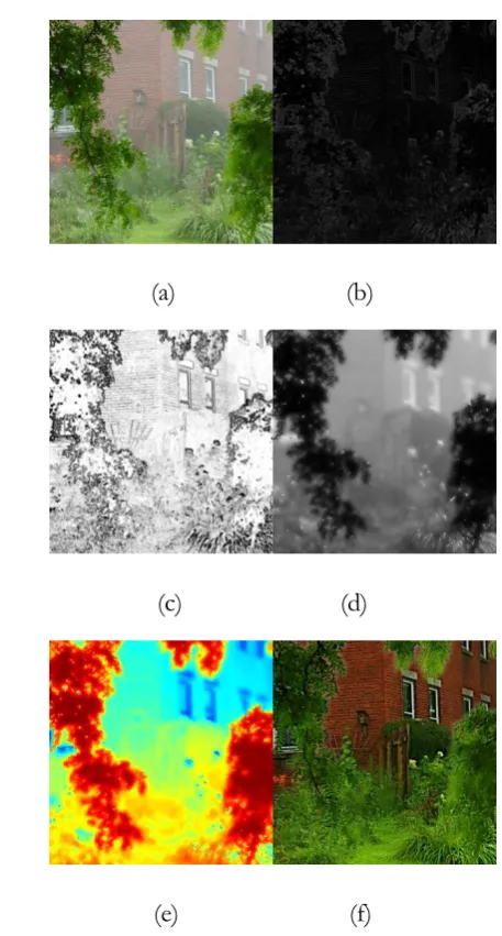
Fig. 3. Estimating the transmission using the edge map and weighting map: (a) degraded image, (b) edge map,
(c) weighting map, and (d) transmission Figure 2(a) shows the degraded input image, and (b) the dark channel calculated for the input image. (c) displays image to remove the effect of the estimated atmospheric light using input image and dark channel. The transmission of light is estimated for images to adjust white balance by removing the effect of the atmospheric light, and this estimated transmission of light is not influenced by the global atmospheric light, so we can say that the pure transmission of light is estimated only.
2.2. Estimating the transmission of light
The transmission of light reflects the degradation degree of the image, which is proportional to the distance. The proposed method distinguishes the edge between the weakly degraded patch and the highly degraded patch, using an edge map in order to estimate the accurate transmission of light. This is the same meaning as distinguishing the near from the far, and the inaccurate edge distinction will consequently affect quality of the restored images, estimating accurate edge is an important issue in estimating accurate transmission of light. Figure 3(a) shows a degraded input image, (b) an edge map to calculate edge of the degraded images, (c) a weighting map to apply weight on an edge map and (d) displays transmission of light estimaged by the proposed method. The edge map is calculated using formula (4) and (5) for the white balance- adjusted images.
(4)
(5)
After calculating the minimum value of RGB in the RGB image to
[image:3.595.46.287.541.745.2]and make it the value of the edge map. Where, is the average of the local patch in centered on , and means pixel contained in the local patch. Therefore, if there are similar pixels in a local patch, they have lower standard deviations. On the other hand, if there are dissimilar pixels in an local patch, they have higher standard deviation. This means the edge can be distinguished. The edge map that distinguishes the edge of degradation degree is converted into a weighting map by applying a weighting function as shown in formula (6).
(6)
[image:4.595.323.534.51.194.2]and are thresholds to determine a shape of the weighting function. If the value of edge map is less than , the weighting map has a value of 1, and if the value of the edge map exceeds , the weighting map has a value of 0. In other cases, the weight is calculated in linear manner. Figure 4 shows the weighting functions for cases where and are 0.1 and 0.5, respectively. The horizontal and vertical axes mean the input and output values, respectively. Therefore, if there are similar pixels in the local patch and the standard deviation is low, the value of the weighting map is 1, while the value of the weight map is 0 if the patch under consideration is the edge patch and has a large standard deviation.
Fig. 4. Weighting function
(a) (b)
[image:4.595.307.536.228.654.2](c) (d)
Fig. 5. Dark channel of variety filter size: (a) 1x1, (b) 3x3, (c) 7x7, and (d) 15x15
(a) (b)
(c) (d)
(e) (f)
[image:4.595.67.276.457.746.2]International Journal of Innovative Technology and Exploring Engineering (IJITEE) ISSN: 2278-3075, Volume-8 Issue-8S2, June 2019
(a) (b)
(c)
(d) (e)
(f)
(g) (h)
(i)
(j) (k)
(m) (o)
[image:6.595.48.243.48.246.2](p)
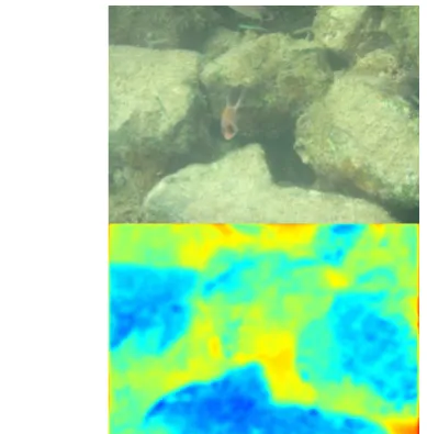
Fig. 7. Results of proposed method: (a),(d),(g),(j),(m) degraded image, (b),(e),(h),(k),(o) transmission, and
(c),(f),(i),(l),(p) recovering image This paper proposes an adaptive dark channel to prevent
halo effect efficiently. The adaptive dark channel sets the filter size of the dark channel largely in order to increase the range of the local patch having a high weight according to the weighting map calculated as above. On the other hand, it sets the filter size in small in order to reduce the range of the local patch having a low weight, which is a method to change the size of filter adaptively and to preserve the edge.Figure 5 shows the dark channel according to the filter size which is the range of local patch. (a) indicates the case where the horizontal and vertical size of filter is 1, (b) indicates the case where the horizontal and vertical size of filter 3, (c) indicates the case where the horizontal and vertical size of filter 7 and (d) indicates the case where the horizontal and vertical size of filter 15, respectively.
The formula used to set filter size adaptively using the weighting map is shown in Formula (7).
(7)
Where, means filter size, means the weighting map and is a factor to determine the maximum filter size. If an edge exists at the location under consideration and the standard deviation is high, the value of the weighting map is calculated to be low, and in the opposite case, the value of the weighting map is calculated to be high due to the low standard deviation. With this in mind, if the value of the weighting map is zero, the filter size becomes 1, and if the value of the weighting map is 1, the filter size becomes the maximum. Also, if the value of the weighting map is an even number, ‘1’ is added to make an odd number, and the range of filter size becomes
[1,…, ].
Figure 6 shows the process of the proposed method. (a) expresses the degraded image, (b) the edge map using standard deviation, (c) the weighting map to which a weighting function is applied, (d) an adaptive dark channel in which the edges are preserved, and (e) the transmission of light. The transmission of light is a single channel, but the red represents a short distance, and the blue a long distance. Finally, (f) shows the restored image. A formula to obtain the transmission of light using an adaptive dark channel is defined as shown in Formula (8).
(8)
means the transmission of light, is a factor to play a role of the global weight. is an adaptive dark channel calculated, considering to apply filter size differently.
2.3. Image Restoration
In order to restore the final degraded image, Formula (9) can be defined to apply Formula (1).
=
(9)
Where, and are the global atmospheric light and the transmission of light, respectively, and is a factor to prevent it from being divided by zero. The degraded image can be restored using the global atmospheric light and the transmission of light estimated as above, along with Formula (9).
III. EXPERIMENTALRESULTS
The filter size of the dark channel used in the experiment was 15×15, the size of the local patch to obtain the edge map was 3×3, and and were 0.01 and 0.2 respectively, was 15 and was 0.1.
Figure 7 shows the results of the proposed method. The left column is a degraded image, and the middle column is the transmission of light, the red shows a short distance and the blue a long distance. The right column shows the restored images. The first and second rows are the ideally degraded images from the short distance to the long distance and their results, which were photographed outdoors, and the third row is the input of images photographed indoors. The fourth row is the result of experiment on aerial images, and the fifth row is the result of experiment on underwater images. With the exception of underwater images, the
[image:6.595.304.549.49.205.2]International Journal of Innovative Technology and Exploring Engineering (IJITEE) ISSN: 2278-3075, Volume-8 Issue-8S2, June 2019
And, except that the aerial images were excessively restored and darkened, it can be seen that the color was restored from the other images and the images under circumstances unaffected by the environment were restored.
IV. CONCLUSION
This paper proposed an adaptive dark channel using the weighting map to apply an edge map and a weighting function in order to restore the degraded digital image contents. As an adaptive dark channel preserves edges and estimates the transmission of light, the naturally restored image can be obtained. Additionally, the global atmospheric light estimated in the course of restoring images can be used for white balancing, and the transmission of light can be also used for estimating the distance from a single image. Experimental results show that the degraded image can be restored using the proposed method to reproduce a richer color.
ACKNOWLEDGMENT
FUNDING FOR THIS PAPER WAS PROVIDED BY NAMSEOUL UNIVERSITY.
REFERENCES
1. Theorie der horizontalen sichtweite, H. Joschmieder, 1924, Beitr. Phys. Freien Atm., pp. 171-181.
2. Visibility in bad weather from a single image, R. Tan, 2008, Proc. IEEE Conference on Computer Vision and Pattern Recognition, pp. 1-8. 3. Single Image dehazing, R. Fattal, 2008, ACM Transactions on Graphics,
vol. 27, pp. 1-9.
4. Instant dehazing of images using polarization, Y. Y. Schechner, S. G. Narasimhan, and S. K. Nayer, 2001, Proc. IEEE Conference on Computer Vision and Pattern Recognition, vol. 1, pp. 325-332.
5. Blind haze separation, S. Shwartz, E. Namer, and Y. Y. Schechner, 2006, Proc. IEEE Conference on Computer Vision and Pattern Recognition, vol. 2, pp. 1984-1991.
6. Deep photo: Model-based photograph enhancement and viewing, J. Kopf, B. Neubert, B. Chen, M. Cohen, D. Cohen-Or, O. Deussen, M. Uyttendaele, and D. Lischinski, 2008, SIGGRAPH Asia
7. Single Image Haze Removal using Dark Channel Prior, K. He., J. Sun, and X. Tang, 2009, Proc. IEEE Conference on Computer Vision and Pattern Recognition, vol. 1, pp. 1956-1963.
8. Contrast restoration of weather degraded images, S. K. Narasimhan and S. K. Nayer, 2003, IEEE Transactions on Pattern Analysis and Machine Intelligence, vol. 25, pp. 713-724.
9. A closed form solution to natural image matting, A. Levin, D. Lischinski, and Y. Weiss, 2006, Proc. IEEE Conference on Computer Vision and Pattern Recognition, vol. 1, pp. 61-68.
10. A Comparative review of camera calibrating methods with accuracy evaluation, 2002, J. Salvi, X. Armangue, and J. Batle, , Pattern Recognition 35, 2002, pp. 1617-1635.