BELT IN SOUTHWESTERN YUNNAN, CHINA
by
Chun Kit Lai
B.Sc., M.Phil. (University of Hong Kong)
Submitted in fulfilment of the requirements for the degree of
Doctor of Philosophy
University of Tasmania
Hobart
STATEMENT
This thesis contains the results of research done at CODES, the School of Earth
Sciences, University of Tasmania, Hobart, Tasmania, Australia between 2009 and
2012.
This thesis contains no material which has been accepted for the award of any other
higher degree of graduate diploma in any tertiary institution and to the best of the
author’s knowledge and belief. This thesis contains no material previously published
or written by another person, except where due references is made in the text of the
thesis.
This thesis may be made available for loan and limited copying in accordance with
the Copyright Act 1968.
Chun Kit Lai
November, 2012
CODES Centre of Excellence in Ore Deposits
Department of Geology
School of Earth Sciences
University of Tasmania
The Ailaoshan Fold Belt represents an important component of the geologically
complex South China–Indochina suture zone. The fold belt is made up of the Eastern
Ailaoshan (EAL) High–Grade Metamorphic Belt, the Paleozoic Central Ailaoshan
(CAL) Mélange, and the Carboniferous–Triassic Western Ailaoshan (WAL) volcanic
belts. This thesis presents a new, better constrained tectono–magmatic evolution
model for the Ailaoshan Fold Belt based on a detailed compilation of existing Chinese
literature, complemented by extensive new sampling, as well as geochronological
(U–Pb zircon and U–Th/Pb monazite), and whole rock and mineral geochemical data.
Contrasting with most published literature, magmatic rocks within the Paleozoic CAL
Mélange have been found to record two episodes of continental rifting and/or volcanic
passive margin development, one Late Devonian–Early Carboniferous, the other Late
Permian. There is no preserved record of the oceanic crust of the ocean basin which
opened as a result of the Late Devonian–Early Carboniferous rifting episode, and the
other magmatic suite recorded in the CAL is the earliest Mid–Triassic syn–collisional
granitic magmatism. The WAL volcanic belts, in contrast, include fault–bounded
slices of rocks formed during a Late Carboniferous–earliest Mid–Permian continental
rift magmatism, a Mid Permian arc/backarc basin magmatism, a Late Permian
syn–collisional granitic magmatism and an Early Triassic post–collisional magmatism.
Magmatism/metamorphism in the EAL High–Grade Metamorphic Belt has been
determined to have occurred during Neoproterozoic, Mid– to Late–Triassic and
Cenozoic events, with protoliths originating from various magmatic– and sedimentary
A new regional tectonic model based on the newly compiled data suggests that
diachronous continental rift magmatism, leading to volcanic passive margin formation
and break up, occurred in the CAL and WAL during, respectively, Silurian–Late
Devonian/Early Carboniferous (ca. 430–400 Ma and ca. 370–325 Ma) and Late
Carboniferous/Early Permian–earliest Mid–Permian (ca. 300–270 Ma), before which
these terranes were attached to the western South China margin in Eastern Gondwana.
The volcanic passive margin development and the subsequent seafloor spreading
opened the Ailaoshan–Song Ma Paleotethys branch, also known as the
Ailaoshan–Song Ma Ocean.
Ridge push associated with WAL continental rifting may have facilitated the
west–vergent subduction of the Ailaoshan–Song Ma Ocean beneath eastern Indochina
since Early Permian (ca. 280 Ma), producing the Truong Son arc magmatism in
Vietnam. In the WAL, in contrast, Mid Permian (ca. 265 Ma) arc/backarc basin
magmatism may have only been active for a limited time before the WAL arc collided
with and was accreted onto eastern Indochina during late Mid–Permian to Late
Permian. This arc–continent collision has been accompanied by extensive Late
Permian WAL–Truong Son syn–collisional granitic magmatism (ca. 260–250 Ma)
and followed by Early Triassic WAL post–collisional magmatism (ca. 250–245 Ma).
Coevally (ca. 260 Ma), the Emeishan Large Igneous Province located in the western
South China Block, and may have extended to the CAL–Jinshajiang–Song Da
regions.
Continued subduction of the Ailaoshan–Song Ma Ocean remnants may have
eventually led to the South China–Indochina continent–continent collision,
Mid–Triassic to Late Triassic (ca. 230–200 Ma). This may have produced the major
regional unconformity recorded across SE Asia, together with the syn– and
ACKNOWLEDGEMENTS
I owe my deepest gratitude to my supervisors, Prof. Anthony Crawford and Dr.
Sebastien Meffre for their ceaseless guidance and encouragement throughout these
three years. My heartfelt gratitude goes also to Assoc. Prof. Khin Zaw for his valuable
funding and support for this project (as part of the Southeast Asia Ore Deposit
Project).
Field work would not have been possible without the facilitation of Prof. Xieyan Song
(State Key Laboratory of Ore Deposit Geochemistry in Guiyang), Prof. Chuandong
Xue (Kunming University of Science and Technology), Prof. Yuping Liu (State Key
Laboratory of Ore Deposit Geochemistry in Guiyang) and Mr. Yizhao Wang. I am
very grateful for valuable advice and discussions with Prof. Meifu Zhou (University
of Hong Kong), Dr. Jacqueline Halpin, Assoc. Prof. Ron F. Berry, together with my
good friends Mr. Takayuki Manaka, Dr. Abhisit Salam, Dr. Huayong Chen, Dr. Lejun
Zhang and Mr. Jianxiang Guan. I extend thanks and appreciation to the staff, and all
my friends at CODES.
I am also very much indebted to Dr. Karsten Goemann, Phil Robinson, Sarah Gilbert,
Katie McGoldrick and Dr. Ian Little for their generous laboratory support and advice.
.
I sincerely thank my family back in Hong Kong, for their spiritual support and
understanding for my long absence. Finally and most importantly, I am indebted to
CHAPTER ONE INTRODUCTION ... 1
1.1 Purpose and Scope of Study ... 1
1.2 Objectives... 3
1.2.1 Tectonic Evolution of the Ailaoshan Fold Belt ... 3
1.2.2 SE Asia Connection of the Ailaoshan Fold Belt ... 4
1.2.3 Tectonic Relationships with the western South China Block ... 4
1.3 Methodology ... 6
CHAPTERTWO REGIONALANDAILAOSHANGEOLOGY ... 7
2.1 Introduction ... 7
2.2 Regional Geology ... 8
2.3 Geology of the Ailaoshan Fold Belt ... 14
2.3.1 Introduction–– Location, Structure and General Stratigraphy ... 14
2.3.2 Eastern Ailaoshan (EAL) High–Grade Metamorphic Belt ... 24
2.3.3 Early Paleozoic Metasediments and Panjiazhai Metabasalts... 28
2.3.4 Paleozoic Central Ailaoshan (CAL) Mélange... 36
2.3.5 Late Carboniferous–Triassic Western Ailaoshan (WAL) Volcanic Belts .... 39
2.3.6 Current Tectonic Models ... 42
CHAPTER THREE SILURIAN–EARLY DEVONIAN AILAOSHAN MAGMATISM AND SEDIMENTARY PROVENANCE ... 45
3.1 Introduction, Aims and Methodology ... 45
3.1.1 Introduction ... 45
3.1.2 Aims and Methodology ... 46
3.2 Field Geology and Petrography ... 48
3.3 Geochronology ... 54
3.4 Geochemistry ... 58
3.4.1 Panjiazhai Metabasalt ... 58
3.4.2 Silurian–Early Devonian Metasediments ... 62
3.5 Discussion: Ages, Tectonic Settings and Regional Correlations ... 65
3.5.1 Panjiazhai Metabasalt ... 65
3.5.2 Silurian–Early Devonian Ailaoshan Sediments ... 67
3.6 Summary ... 75
CHAPTER FOUR PALEOZOIC CENTRAL AILAOSHAN MELANGE ... 76
4.1 Introduction, Aims and Methodology ... 76
4.1.1 Introduction ... 76
4.1.2 Aims and Methodology ... 77
4.2.1 Introduction ... 79
4.2.2 Ultramafic Rocks ... 82
4.2.3 Gabbro, Dolerite, Plagiogranite, Basalt and Granites ... 85
4.3 Geochronology ... 89
4.4 Geochemistry ... 90
4.4.1 Whole Rock Geochemistry ... 95
4.4.2 Mineral Geochemistry ... 97
4.5 Discussion: Ages, Tectonic Settings and Regional Correlations ... 108
4.5.1 Late Devonian–Early Carboniferous Volcanic Passive Margin Magmatism ... 108
4.5.2 Late Permian Continental Rift Mafic Magmatism ... 113
4.5.3 Earliest Mid–Triassic Syn–collisional Granitoids ... 115
4.6 Summary ... 120
CHAPTER FIVE LATE CARBONIFEROUS–EARLY TRIASSIC VOLCANIC BELTS ... 122
5.1 Introduction, Aims and Methodology ... 122
5.1.1 Introduction ... 122
5.1.2 Aims and Methodology ... 123
5.2 Field Geology ... 125
5.2.1 Late Carboniferous(?)–Earliest Mid–Permian WAL Magmatism .. 錯誤! 尚 未定義書籤。 5.2.2 Mid Permian WAL Mafic Magmatism ... 錯誤! 尚未定義書籤。 5.2.3 Late Permian WAL Granitoids ... 錯誤! 尚未定義書籤。 5.2.4 Early Triassic WAL Mafic Magmatism ... 錯誤! 尚未定義書籤。 5.2.5 Early Triassic WAL Rhyolites ... 錯誤! 尚未定義書籤。 5.3 Geochronology ... 152
5.4 Whole Rock Geochemistry ... 161
5.4.1 Introduction ... 161
5.4.2 Late Carboniferous(?)–Earliest Mid–Permian WAL Magmatism ... 162
5.4.3 Mid Permian WAL Magmatism ... 164
5.4.4 Late Permian WAL Granitic Magmatism ... 166
5.4.5 Early Triassic WAL Magmatism ... 167
5.4.6 Late Permian–Triassic WAL Sandstone ... 168
5.5 Pb–Isotope Geochemistry ... 186
5.6 Discussion: Ages, Tectonic Settings and Regional Correlations ... 188
5.6.1 Introduction ... 188
5.6.4 Late Permian Syn–collisional Granitic Magmatism ... 194
5.6.5 Early Triassic Post–collisional Magmatism ... 195
5.6.6 Late Permian–Triassic WAL Sediments ... 197
5.7 Summary ... 203
CHAPTER SIX EASTERN AILAOSHAN HIGH–GRADE METAMORPHIC BELT ... 204
6.1 Introduction, Aims and Methodology ... 204
6.1.1 Introduction ... 204
6.1.2 Aims and Methodology ... 205
6.2 Field Geology and Petrography ... 206
6.2.1 Felsic Metamorphic Rocks ... 207
6.2.2 Intermediate–Mafic Metamorphic Rocks ... 211
6.2.3 Metagranites ... 216
6.3 Geochronology ... 219
6.3.1 Yuanjiang–Yangdoujie Schist ... 219
6.3.2 Gneiss ... 222
6.3.3 Yuanjiang Quartz–feldspar–two mica–garnet Schist ... 224
6.3.4 Hornblende Metagabbro ... 225
6.3.5 Metagranites ... 227
6.4 Whole Rock Geochemistry ... 231
6.5 Pb–Isotope Geochemistry ... 235
6.6 Discussion... 237
6.6.1 Protoliths Types, Tectonic Origins and Regional Correlations ... 237
6.6.2 Geological Evolution of the EAL High–Grade Metamorphic Belt ... 242
6.7 Summary ... 244
CHAPTER SEVEN TECTONIC EVOLUTION OF THE AILAOSHAN FOLD BELT AND ITS REGIONAL CORRELATION ... 245
7.1 Introduction ... 245
7.2 Towards a New Tectonic Model ... 248
7.2.1 Silurian–Early Devonian (ca. 430–400 Ma) ... 248
7.2.2 Late Devonian–Early Carboniferous (ca. 370–325 Ma) ... 249
7.2.3 Late Carboniferous–earliest Mid–Permian (ca. 300–270 Ma) ... 251
7.2.4 Mid– to Late–Permian (ca. 270–250 Ma) ... 253
7.2.5 Early Triassic (ca. 250–245 Ma) ... 255
7.2.6 Mid– to Late–Triassic (ca. 245–200 Ma) ... 256
LIST OF FIGURES
Figure 1. Simplified regional geological map of Southeast Asia region... 9
Figure 2. Regional geological history of southwestern South China–SE Asia ... 12
Figure 3a. Simplified Ailaoshan geological map published in Shen et al. (1998)………..16
Figure 3b. Simplified geological map of the Ailaoshan Fold Belt... 17
Figure 4. Simplified geological map of the Eastern Ailaoshan (EAL) High–Grade Metamorphic Belt . 27 Figure 5. Simplified geological map of the Silurian–Early Devonian (meta)sediments and (meta)basalts ... 29
Figure 6. Simplified geological map of the Paleozoic CAL Mélange ... 38
Figure 7. Simplified geological map of the Western Ailaoshan (WAL) volcanic belts ... 41
Figure 8. Simplified geological map of the Silurian–Early Devonian (meta)sediments and (meta)basalts with the key sampling sites shown ... 49
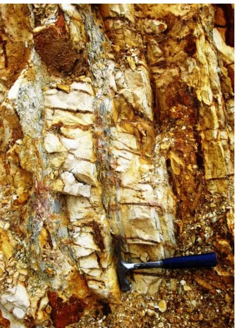
Figure 9. Intensely deformed Silurian–Early Devonian metasandstone and metasiltstone ... 50
Figure 10. Mylonitic Silurian–Early Devonian quartz–lithic metasandstone: crossed polars ... 50
Figure 11. Silurian–Early Devonian thickly bedded white sandstone–siltstone interbeds, Yangdoujie . 51 Figure 12. Undeformed coarse quartz lithic sandstone: crossed polars ... 51
Figure 13. Phyllitic coarse quartz–lithic metasandstone, Panjiazhai ... 52
Figure 14. Phyllitic coarse quartz–lithic metasandstone showing two phases of deformation (D1 and D2): crossed polars ... 53
Figure 15. Probability plot of a metasandstone (K10–73) outcropping near the reported Panjiazhai metabasalt outcrop site ... 55
Figure 16. Probability plot of detrital zircon ages of Early Silurian sandstone and Late Silurian–Early Devonian metasandstones ... 57
Figure 17. Major and trace element plots against MgO for the Panjiazhai metabasalt ... 59
Figure 18. Zr/Y vs Zr/Nb and Nb/Y vs Zr/Nb plots for the Panjiazhai metabasalt ... 60
Figure 19. REE/Chondrite and Rock/N–MORB plots for the Panjiazhai metabasalts ... 61
Figure 20. Harker–type diagrams of Early Silurian– and Late Silurian–Early Devonian metasandstones ... 63
Figure 21. Rock/N–MORB plot for the Early Silurian– and Late Silurian–Early Devonian Ailaoshan metasandstones ... 64
Figure 22. Qm–F–Lt ternary diagram for the Silurian–Early Devonian Ailaoshan metasandstones ... 68
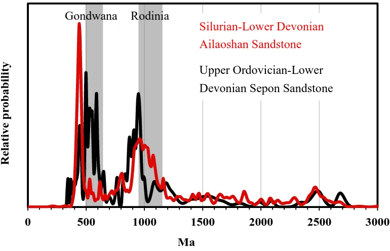
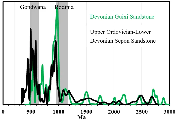
Figure 23. Probability plot of detrital zircon ages of the Silurian–Early Devonian Ailaoshan sandstone and the Devonian Guixi sandstone in northwestern South China Block ... 72
Figure 24. Probability plot of detrital zircon ages of the Silurian–Early Devonian Ailaoshan sandstone and the Late Ordovician–Late Devonian Sepon sandstone in the Truong Son Fold Belt ... 73
Figure 25. Probability plot of detrital zircon ages of the Devonian Guixi sandstone in northwestern
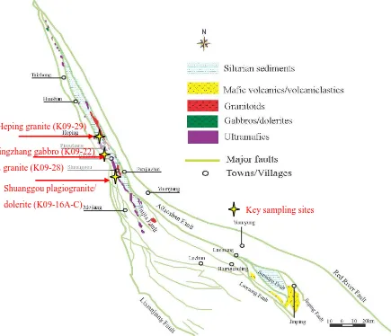
Figure 26. Simplified geological map of the Paleozoic CAL Mélange with the key sampling sites
shown ... 80
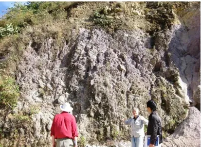
Figure 27. Paleozoic CAL Mélange in Pingzhang, showing magmatic rock cobbles in a mud matrix .. 81
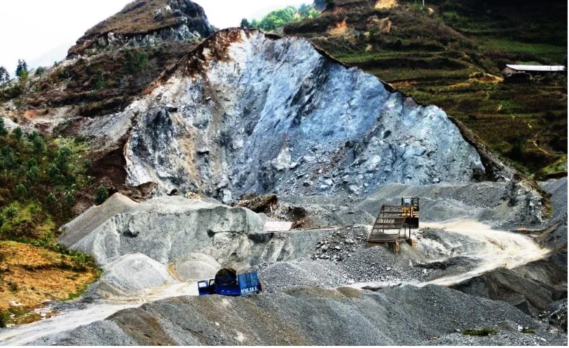
Figure 28. Serpentinized ultramafic rocks in a quarry, Yangdoujie ... 82
Figure 29. Sheared and serpentinized ultramafic rocks along the Jiujia Fault, Shuanggou ... 83
Figure 30. Serpentinized lherzolite with fresh augite: crossed polars ... 833
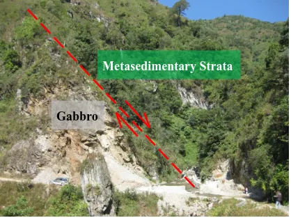
Figure 31. Gabbroic mega–block in faulted contact with Silurian–Devonian metasediments, Pingzhang. ... 866
Figure 32. Metadolerite with altered clinopyroxene and plagioclase: crossed polars ... 877
Figure 33. Texturally well–preserved plagiogranite: crossed polars ... 877
Figure 34. Coarse metabasalt with altered augite and microcrystalline epidote replacing plagioclase, and chlorite after interstitial glassy mesostasis: crossed polars... 88
Figure 35. U–Pb inverse concordia diagram showing zircons from the Early Carboniferous Shuanggou dolerite (K09–16A) ... 91
Figure 36. U–Pb inverse concordia diagram showing zircons from the Late Devonian Shuanggou dolerite (K09–16B) ... 91
Figure 37. U–Pb inverse concordia diagram showing zircons from the Early Carboniferous Shuanggou dolerite (K09–16C) ... 92
Figure 38. U–Pb inverse concordia diagram showing zircons from the Late Permian Pingzhang gabbro (K09–22) ... 92
Figure 39. U–Pb inverse concordia diagram showing zircons from the Mid Triassic Pingzhang granite (K09–28) ... 93
Figure 40. U–Pb inverse concordia diagram showing zircons the Early Oligocene Heping granite (K09–29) ... 93
Figure 41. Zr/Y vs Zr/Nb and Nb/Y vs Zr/Nb for the CAL mafic rocks. ... 98
Figure 42. FeO* vs FeO*/MgO diagram for the CAL mafic rocks. ... 99
Figure 43. Major and trace element plots against MgO for the CAL mafic rocks. ... 100
Figure 44. REE/Chondrite and Rock/N–MORB plots for the Suite DC1 mafic rocks ... 101
Figure 45. REE/Chondrite and Rock/N–MORB plots for the Suite DC2 mafic rocks ... 102
Figure 46. REE/Chondrite and Rock/N–MORB plots for the Late Permian CAL mafic rocks... 103
Figure 47. Chemical composition of the earliest Mid–Triassic CAL syn–collisional granite in terms of alumina saturation ... 104
Figure 48. Harker–type diagrams for earliest Mid–Triassic CAL syn–collisional granites. ... 105
Figure 49. REE/Chondrite and Rock/N–MORB plots for the earliest Mid–Triassic CAL peraluminous granite ... 106
Figure 51. REE/Chondrite and Rock/N–MORB plots for comparing the Late Devonian–Early
Carboniferous CAL Suite DC2 rocks and the Carboniferous Jinshajiang magmatism ... 1162
Figure 52. REE/Chondrite and Rock/N–MORB plots for comparing the Late Devonian–Early
Carboniferous CAL Suite DC2 rocks and the Honvang gabbros (Group A) in the Song Ma region
... 117 Figure 53. REE/Chondrite and Rock/N–MORB plots for comparing the Late Permian CAL mafic rocks
and the Song Ma (Honvang) gabbros (Group B), as well as the lower–Ti Song Da– and ELIP
continental rift basalt ... 118
Figure 54. Rb/(Y+Nb) and Nb/Y binary plots for the earliest Mid–Triassic peraluminous CAL granite
... 119 Figure 55. Simplified geological map of the Western Ailaoshan (WAL) volcanic belts with the key
sampling sites shown ... 錯誤! 尚未定義書籤。 Figure 56. Intensely deformed pillow basalt, Wusu ... 錯誤! 尚未定義書籤。 Figure 57. Pillow basalt (altered)–limestone faulted contact, Taichong ... 錯誤! 尚未定義書籤。
Figure 58. Coarse basaltic dyke with augite plates subophitically including plagioclase laths: crossed
polars ... 錯誤! 尚未定義書籤。 Figure 59. Vesicular basalt with vesicles filled with epidote: crossed polars ... 錯誤! 尚未定義書籤。 Figure 60. Sequence of well–exposed Baliu interbedded rhyolite–turbiditic sandstone . 錯誤! 尚未定義
書籤。
Figure 61. Volcaniclastic lithic sandstone overlain by siltstone and fiamme–bearing rhyolitic ignimbrite,
Baliu ... 錯誤! 尚未定義書籤。 Figure 62. Fossiliferous limestone, Baliu ... 錯誤! 尚未定義書籤。 Figure 63. Well–preserved pillow basalt, Shuanglong ... 錯誤! 尚未定義書籤。 Figure 64. Lava tube among basaltic pillows, Shuanglong ... 錯誤! 尚未定義書籤。 Figure 65. Volcaniclastic red sandstone conformably overlying pillow lava, Nanqueqiao . 錯誤! 尚未定
義書籤。
Figure 66. Pillow lava grading upward to basalt autobreccia and then volcaniclastic red sandstone,
Nanqueqiao ... 錯誤! 尚未定義書籤。 Figure 67. Thick volcaniclastic red sandstone and limestone/marl interbeds, Mojiang .. 錯誤! 尚未定義
書籤。
Figure 68. Ferruginous quartz–lithic sandstone: crossed polars ... 錯誤! 尚未定義書籤。
Figure 69. Volcaniclastic conglomerate with clasts of gabbro, quenched basalt and sandstone: crossed
polars ... 錯誤! 尚未定義書籤。
Figure 70. Volcaniclastic sandstone with altered feldspar and augite and clasts of basalts: crossed polars
limestone and quenched basalt ... 錯誤! 尚未定義書籤。 Figure 75. Interbedded sandstone–siltstone, Banpo ... 錯誤! 尚未定義書籤。
Figure 76. Turbiditic coarse quartz–lithic–sandstone with volcanic quartz and fragments of granite
(with granophyric texture), chert, limestone and volcanic rocks: crossed polars ... 錯誤! 尚未定義 書籤。
Figure 77. Granitoid (weathered) intruding and including xenoliths of Silurian sandstone–siltstone
sequence, Pinghe ... 錯誤! 尚未定義書籤。 Figure 78. Quartz diorite intruded by aplite dykes, Huangcaoling ... 錯誤! 尚未定義書籤。 Figure 79. Hornblende–biotite granite intruded by coarse aplite vein: crossed polars 錯誤! 尚未定義書
籤。
Figure 80. Hornblende–biotite granite with granophyric texture: crossed polars 錯誤! 尚未定義書籤。
Figure 81. Cumulate wehrlite: crossed polars ... 錯誤! 尚未定義書籤。 Figure 82. Gabbros in faulted contact with sandstone, Daheishan ... 錯誤! 尚未定義書籤。 Figure 83. Doleritic sills intruding black shale, Banpo. ... 錯誤! 尚未定義書籤。 Figure 84. Altered olivine dolerite: crossed polars ... 錯誤! 尚未定義書籤。 Figure 85. Deformed rhyolitic lava interbedded with sandstone–siltstone, Luchun .... 錯誤! 尚未定義書
籤。
Figure 86. Quartz–phyric rhyolitic lava with pumice fragment in a devitrified groundmass, plane polars
... 錯誤! 尚未定義書籤。 Figure 87. U–Pb inverse concordia diagram of zircons from the Baliu rhyolitic ignimbrite (K10–56)153
Figure 88. U–Pb inverse concordia diagram of zircon from the Pingzhang gabbro (K09–25) ... 153
Figure 89. U–Pb inverse concordia diagram of zircons from the Daheishan dolerite sill (K09–80) .... 154
Figure 90. U–Pb inverse concordia of zircons from the Pinghe granite (K10–25) ... 154
Figure 91. U–Pb inverse concordia diagram of zircons from the Pinghe granite (K10–29) ... 155
Figure 92. U–Pb inverse concordia diagram of zircons from the Luchun rhyolite (K09–83). ... 155
Figure 93. U–Pb inverse concordia diagram of zircons from the Luchun rhyolite (K09–87) ... 156
Figure 94. Probability plot of detrital zircon ages of Late Permian–Triassic WAL sandstones. ... 160
Figure 95. Cumulative probability plot of 565 detrital zircon ages of zircons from Late Permian–Triassic WAL sandstones ... 160
Figure 96. Zr/Y vs Zr/Nb and Nb/Y vs Zr/Nb plots for the major WAL mafic magmatic units ... 169
Figure 97. FeO* vs FeO*/MgO diagram for the major WAL mafic magmatic units ... 170
Figure 98. Major and trace element plots against MgO for the major WAL mafic magmatic units ... 171
Figure 99. Harker–type diagrams of the WAL rhyolites. ... 172
Figure 100. REE/Chondrite and Rock/N–MORB plots for the Late Carboniferous(?)–Early Permian WAL basalts–basaltic andesites ... 173
Figure 102. REE/Chondrite and Rock/N–MORB plots for the earliest Mid–Permian WAL continental
rift mafic rocks ... 175
Figure 103. REE/Chondrite and Rock/N–MORB plots for the Mid Permian WAL arc–backarc basin
basalt–andesite. ... 176
Figure 104. Rock/N–MORB plot for the Mid Permian WAL arc–backarc basin rhyolites . ... 177
Figure 105. Chemical composition of the Late Permian WAL early syn–collisional granites in terms of
alumina saturation index ... 178
Figure 106. Harker–type diagrams for the Late Permian WAL early syn–collisional granites ... 179
Figure 107. Zr vs (10000Ga/Al) and (K2O+Na2O) vs (10000Ga/Al) plots for the Late Permian WAL
early syn–collisional granites ... 180
Figure 108. REE/Chondrite and Rock/N–MORB plots for the Late Permian WAL peraluminous early
syn–collisional granites ... 181
Figure 109. REE/Chondrite and Rock/N–MORB plots for the Early Triassic post–collisional Daheishan
dolerite ... 182
Figure 110. REE/Chondrite and Rock/N–MORB plots for the Early Triassic post–collisional Luchun
rhyolites ... 183
Figure 111. Harker–type diagrams of Late Permian–Triassic WAL sandstone ... 184
Figure 112. Rock/N–MORB plot for the Late Permian–Triassic WAL sandstone. ... 185
Figure 113. 207Pb/204Pb vs. 206Pb/204Pb diagram for the Late Permian WAL granites derived from K–feldspar ... 186
Figure 114. Rb/(Y+Nb) and Nb/Y binary plots for the Late Permian WAL early syn–collisional granite
... 200 Figure 115. Rb/(Y+Nb) and Nb/Y binary plots for the WAL rhyolites ... 201
Figure 116. Qm–F–Lt ternary diagram for the Late Permian–Triassic WAL sandstone ... 202
Figure 117. Probability plot of detrital zircon ages of Late Permian–Triassic– and Silurian–Early
Devonian Ailaoshan sandstones ... 202
Figure 118. Simplified geological map of the EAL High–Grade Metamorphic Belt with the key
sampling sites shown ... 206
Figure 119. Quartz–feldspar–2 mica gneiss (aka. Ailaoshan Group) with gneissic banding showing
sinistral deformation, Yuanjiang ... 208
Figure 120. Porphyroblastic quartz–feldspar–2 mica gneiss: crossed polars ... 208
Figure 121. Highly deformed schist (aka. Dahebian Group), Yangdoujie ... 209
Figure 122. Quartz–feldspar–2 mica schist with biotite and mica aligned along the foliation: crossed
polars ... 210
Figure 123. Quartz–feldspar–two mica–garnet schist with pressure shadows showing sinistral
deformation, western Yuanjiang ... 212
Figure 124. Porphyroblastic quartz–feldspar–two mica–garnet schist with garnet porphyroblasts
recrystallized quartz: crossed polars ... 213
Figure 126. Crenulation cleavage (D1) cut by later shear (D2) in foliated hornblende metagabbro, western Yuanjiang ... 214
Figure 127. Foliated hornblende metagabbro with hornblende lineated along foliation plane: crossed polars ... 215
Figure 128. Massive undeformed metagranite in contact with strongly deformed gneiss, Yuanjiang .. 217
Figure 129. Massive foliated metagranite body near the Ailaoshan Fault, showing pronounced foliation defined by biotite and amphibole, Mosha ... 218
Figure 130. Foliated and deformed metagranite. Crossed polars ... 218
Figure 131. CL image of the Yuanjiang–Yangdoujie muscovite–biotite schist (SM09–119) ... 220
Figure 132. Time resolved LA–ICPMS age signal for a zircon from the Yuanjiang–Yangdoujie schist (SM09–119) ... 220
Figure 133. Probability plot of zircon age population for two Yuanjiang–Yangdoujie quartz–feldspar–2 mica schist (SM09–118 and SM09–119) ... 221
Figure 134. U–Pb inverse concordia of monazite from the Laomeng gneiss (K09–44) ... 223
Figure 135. U–Pb inverse concordia of zircons from the Menghao gneiss (K10–05) ... 223
Figure 136. U–Pb inverse concordia of zircons from the Yuanjiang garnet–bearing schist (K09–05) . 224 Figure 137. U–Pb inverse concordia of zircons from the Yuanjiang metagabbro (K09–01) ... 225
Figure 138. U–Pb inverse concordia of zircons from the Menghao metagabbro (K10–08) ... 226
Figure 139. U–Pb inverse concordia of monazites from the Menghao metagabbro (K10–08) ... 226
Figure 140. U–Pb inverse concordia of zircons from the metagranite (K09–27) ... 227
Figure 141. Probability density plot for the metagranite (K09–30) ... 228
Figure 142. U–Pb inverse concordia of zircons from the metagranite (SM09–111) ... 229
Figure 143. U–Pb inverse concordia of zircons from the metagranite (SM09–114) ... 229
Figure 144. U–Pb inverse concordia of zircons from the metagranite (K09–02) ... 230
Figure 145. Chemical composition plots: a. Al2O3/(K2O+Na2O) vs. Al2O3/(K2O+Na2O+CaO) b. MgO/FeO* vs. (Zr+Nb+Ce+Y) c. Rb vs. (Nb+Y) and Nb vs. Y for the Yuanjiang–Yangdoujie schist (SM09–118 and SM09–119), Yuanjiang–Yangdoujie metagranite (K09–02) and Laomeng gneiss (K09–44) ... 233
Figure 146. Rock/N–MORB plot for the Yuanjiang–Yangdoujie schist (SM09–118 and SM09–119), Yuanjiang–Yangdoujie metagranite (K09–02) and Laomeng gneiss (K09–44). ... 234
Figure 147. K–feldspar 207Pb/204Pb vs 206Pb/204Pb diagram for the Laomeng gneiss (K09–44) and the Yuanjiang–Yangdoujie metagranite (K09–02). ... 236
Figure 148. Probability plot of zircon ages of the Yuanjiang–Yangdoujie schist (SM09–118 and SM09–119) ... 238
Figure 149. Probability plot of detrital zircon ages of the Laomeng gneiss (K09–44). ... 240
Table 1. Summary of major Silurian–Early Carboniferous CAL magmatic suites. ... 18
Table 2. Summary of major Late Carboniferous–Early Triassic Ailaoshan magmatic suites. ... 19
Table 3. General stratigraphy of the Ailaoshan Fold Belt. ... 30
Table 4. Summary of the paleontological and U–Pb detrital zircon age constraints on the Silurian–Early
Devonian magmatism and the associated sediments. ... 56
Table 5. Summary of the paleontological and U–Pb zircon age constraints on the CAL magmatism and
the associated sediments. ... 94
Table 6. Summary of the paleontological and U–Pb zircon age constraints on the WAL magmatism and
CHAPTER ONE
INTRODUCTION
1.1 Purpose and Scope of Study
The Ailaoshan, meaning mountain of the Ailao tribe in Chinese, Fold Belt strikes
NW–SE across the central part of southwestern Yunnan (Fig. 1). Around 500 km long,
with width varying from 20–100 km and an average height around 2000 m a.s.l., the
mountain range forming this fold belt peaks at Mount Ailao (3166 m), and the high,
steep and rugged Ailaoshan topography renders the mountain belt one of the most
inaccessible areas in the region. The geographic remoteness of the Ailaoshan Fold
Belt not only preserves a high floral and faunal diversity and an extraordinarily rich
aboriginal tribal culture, but until recently, it has also largely precluded detailed
geological studies of the mountain belt.
The Ailaoshan Fold Belt represents the suture between the South China Block and the
Indochina Block, and therefore records different geological episodes of the complex
tectonic history resulting from interactions between these two crustal blocks. Despite
its regional geological importance, the tectonic evolution of the Ailaoshan Fold Belt is
remains inadequately understood. Moreover, on–going controversies exist concerning
the extent and identification of the southeast end of the Ailaoshan Fold Belt, as well as
its geological correlations with the South China and Indochina blocks.
Via a detailed examination of the petrology, geochronology and geochemistry of key
rock packages in the Ailaoshan Fold Belt, this project aims to: First, reconstruct the
1.2 Objectives
This project aims to elucidate the tectono–magmatic evolution of the Ailaoshan Fold
Belt via coupled geochronological and geochemical studies of diverse igneous and
metamorphics which form complex, discontinuous belts along much of the length of
the mountain belt. This broader objective is addressed via focused studies of
important magmatic and metamorphic belts across the region of interest. These are
listed below as an outline of key objectives for each belt.
1.2.1 Tectonic Evolution of the Ailaoshan Fold Belt
Silurian–Early Devonian Magmatism and Sedimentary Provenance
To constrain the age for the mid–Paleozoic magmatism and (meta)sediments
in the region.
To investigate the provenance of the (meta)sediments and the tectonic setting
of eruption of the magmatic rocks.
Paleozoic Central Ailaoshan (CAL) Mélange
To definitively determine the distribution, extent and nature of the CAL
Mélange, and clarify some of the existing uncertainty around this key unit.
To constrain the formation age(s) for the magmatic rocks in the CAL.
To investigate the tectonic setting(s) of the magmatic rocks, and their genetic
relationships if any with the Late Carboniferous–Triassic Western Ailaoshan
To systematically redefine the volcanic units of this age on the basis of
published and new geochronological and geochemical information.
To better constrain the formation age of the various volcanic units and their
associated sediments.
To determine the affinities, genetic relationships and tectonic implications of
the various volcanic units.
To determine the age spectra and possible provenance areas of the associated
Late Paleozoic sediments in the region using detrital zircon populations, and
implications for tectonic reconstructions.
Eastern Ailaoshan (EAL) High–Grade Metamorphic Belt
To determine the age and nature of protoliths of the major metamorphic units.
To constrain their timing of formation and metamorphic ages by means of
U–Pb zircon and U–Th/Pb monazite dating.
1.2.2 SE Asia Connection of the Ailaoshan Fold Belt
To compare the Ailaoshan (meta)sediment age(s) and provenance(s) with
those documented in the literature for key (meta)sedimentary units in SE Asia.
To compare the petrology and geochemistry of the key magmatic units of the
Ailaoshan Fold Belt with those of the magmatic units in nearby SE Asia.
1.2.3 Tectonic Relationships with the western South China Block
those documented in the literature for key (meta)sedimentary units in the
southwestern South China Block.
To compare the petrology and geochemistry of the magmatic units of the
Ailaoshan Fold Belt with those of the magmatic units in nearby South China,
1.3 Methodology
Three field trips were conducted for this study, during April and October 2009, and
November 2010, to investigate the field geology and to collect samples for the project.
Traverses were conducted along east–west trending transects which were broadly
perpendicular to the strike of major lithological units. Two areas, namely the
Shuanggou–Pingzhang and Mojiang–Banpo areas, were chosen for study in greater
detail because of the good exposure of, respectively, the Paleozoic CAL Mélange, and
the Late Carboniferous–Triassic WAL volcanic belts. From these three trips, 300
representative samples were collected. Time and access constraints ruled that detailed
geological mapping was not a viable option for this project. Therefore, efforts were
focused on comprehensive sampling of key units based on mapping by Chinese
government geological teams (Regional Geological Surveying Party, 1990).
Samples collected in the field were first thin sectioned for petrographic analysis. Key
samples, selected on the basis of their freshness and regional significance, were
subjected to further geochronological, geochemical and isotopic examination in the
laboratories at the University of Tasmania. Geochronological investigation mainly
involved LA–ICPMS U–Pb zircon and U–Th/Pb monazite analysis. Geochemical
investigation included whole–rock XRF (for major– and certain trace elements) and
solution ICPMS (for other trace elements) analyses, together with mineralogical
(Cr–spinel) electron microprobe analysis. In addition, K–feldspar Pb–isotope analysis
CHAPTER
TWO
REGIONAL
AND
AILAOSHAN
GEOLOGY
2.1 Introduction
This chapter presents a comprehensive review of the geology of the Eastern Ailaoshan
(EAL) Metamorphic Belt and the complex Paleozoic Central Ailaoshan (CAL)
Mélange and Late Carboniferous(?)–Early Triassic Western Ailaoshan (WAL)
volcanic belts to the west. Specific attention was paid to published geochemical data
for magmatic rocks in the region, and as a result of a careful compilation of this data,
a number of clear geochemical groupings and correlations have emerged which were
not evident in the literature until this compilation (Tables 1 and 2).
The chapter begins with a brief review of the geological history in SE Asia (Section
2.2). Following this overview, focus is moved back to the current understanding of the
2.2 Regional Geology
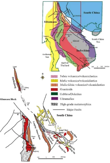
The Ailaoshan Fold Belt represents the suture zone between the South China Block
and the Indochina Block. The fold belt is bounded by the Red River Fault in its east
and the Lixianjiang Fault in its west (Fig. 3). In Chinese literature, the Ailaoshan Fold
Belt is often referred as the Ailaoshan–Jinshajiang Suture Zone, implying probable
correlation between the two fold belts (e.g., Wang et al., 2000). The southeast
continuation, however, is more controversial. Various arguments have been made that
the Ailaoshan Fold Belt may be linked with the Song Ma and/or Song Da region(s) in
northwestern Vietnam (e.g., Chung et al., 1997; Yumul et al., 2008). In terms of
geological history, the Ailaoshan Fold Belt has long been suggested to represent a
branch of the Paleotethys, called the Ailaoshan–Song Ma Paleotethys branch. The
main Paleotethys has been suggested to be the Jinghong Fold Belt (or the Southern
Lancanjiang Fold Belt) and/or the Changning–Menglian Fold Belt to the west of the
Simao Terrane (Fig. 1) (Cao, 2004; Metcalfe, 2006; Metcalfe, 2009; Sone and
Figure 1. Simplified regional geological map of Southeast Asia region. Modified from Tran et al.
(1979), Xu et al. (2001), Sone and Metcalfe (2008), Tran et al. (2008), Jian et al. (2009) and Meffre et
al. (2010).
[image:26.595.117.488.74.622.2]started from the Silurian (Fig. 2), during which continental rifted related amphibolite
xenoliths (443–401 Ma) were found in the Jinshajiang Fold Belt (Jian et al., 2009b).
Broadly coeval Silurian ages have also been reported from a rhyolite (U–Pb zircon:
434–428 Ma) in the Loei Fold Belt (Khositanont et al., 2008), and the Silurian
collisional–related Song Chay–Laojunshan granitoids (ca. 442–418 Ma) are
well–known from southeastern Yunnan–northern Vietnam (Guo et al., 2009; Roger et
al., 2000; Yan et al., 2006). Late Devonian–Early Carboniferous magmatism, with
controversial tectonic setting(s), has been reported along the central Jinshajiang
(U–Pb zircon: ca. 346–341 Ma) (Jian et al., 2009b; Jian et al., 2008; Jian et al.,
1999)–Ailaoshan (U–Pb zircon: ca. 387–328 Ma (Jian et al., 2009b; Jian et al., 1998))
region, as well as in the Loei Fold Belt (whole rock Rb–Sr: 361±11 Ma) (Intasopa and
Figure 2. Regional geological history of southwestern South China–SE Asia. Reference from e.g.,
Zhong et al. (1998), Roger et al. (2000), Wang et al. (2000), Xu et al. (2001), Zhou et al. (2002a),
Panjasanwawong et al. (2006), Khositanont et al. (2008), Tran et al. (2008a), Cai and Zhang (2009),
[image:29.595.113.459.82.647.2]The geological evolution of this part of SE Asia started to vary significantly in
different parts of the region from Late Carboniferous. With tectonic activity largely
quiescent along the central Jinshajiang–Ailaoshan region and in much of western
South China (until Late Permian) (e.g., Cai and Zhang, 2009; Shen et al., 2001; Wang
et al., 2000), arc magmatism is reported in the western Jinshajiang (e.g., Jian et al.,
2009b; Xie et al., 2005) – Ailaoshan (e.g., Liu et al., in press; Tran et al., 2008a) –
Truong Son (Song Ca) (e.g., Liu et al., in press; Tran et al., 2008a) regions during
Early– to Mid–Permian, Mid– to Late–Permian and Late Permian–Early Triassic. In
western South China, magmatism recommenced during Late Permian (ca. 260 Ma)
with the eruption of Emeishan Large Igneous Province (e.g., He et al., 2007b;
Shellnutt et al., 2008). Regional continuations of the Emeishan Large Igneous
Province are also reported in parts of the Jinshajiang (Xiao et al., 2008) and Song Da
(Balykin et al., 2010; Polyakov et al., 1991; Polyakov et al., 1998; Tran et al., 2011)
regions. Indochina–South China continent–continent collision(s), marked by
widespread unconformity and granitic/rhyolitic magmatism, has/have been suggested
to have occurred during Silurian–Early Carboniferous (Carter and Clift, 2008; Chen et
al., 2011; Hung, 2010b; Lepvrier et al., 2004; Lepvrier et al., 2008), Permian–Early
Triassic and/or Mid– to Late–Triassic (e.g., Jian et al., 2009a; Jian et al., 2009b; Tran
2.3 Geology of the Ailaoshan Fold Belt
2.3.1 Introduction–– Location, Structure and General Stratigraphy
The Ailaoshan Fold Belt, ca. 500 km long and 20–100 km wide, is bounded by the
Simao and Indochina blocks to its west along the Lixianjiang Fault (Xiong et al.,
1998). The Red River Fault (or Yuanjiang Fault) forms the northeast margin of the
Ailaoshan Fold Belt with the South China Block. To the northwest of the Ailaoshan
Fold Belt is the Jinshajiang Fold Belt. To the south and southeast of Ailaoshan Fold
Belt are the Loei Fold Belt of Thailand–Laos, and the various northern Vietnam
subterranes (e.g., Hung, 2010a; Krobicki et al., 2008; Lepvrier et al., 2008; Tran et al.,
2008b; Tran, 1979). Among the latter, the Song Hien– and Song Da rifts (Chung et al.,
1997; Hanski et al., 2004; Tran et al., 2008b) are suggested to have South China
Block–affinities, whereas the Truong Son Fold Belt (Liu et al., in press; Tran et al.,
2008a) has been suggested to be associated with the Indochina Block (Fig. 1). The
Song Ma Terrane (Findlay, 1997; Findlay and Phan, 1997; Hutchison, 1975; Le et al.,
1982; Tran, 1979) has been suggested to be a southern extension of the
Jinshajiang–Ailaoshan suture zone.
The literature referenced in this thesis, whether Chinese or international, is all taken
from published papers in international or Chinese journals. It is true that much of the
Chinese literature has rather primitive maps and imprecise sampling locations, due
mainly to the lack of global positioning system (GPS) and reference points (e.g., cities
or roads) when most of these literature were published more than 20 years ago. The
descriptions, geochemical and mineralogical data of reasonable quality, as well as
robust and sound discussions. Based on spot checks on numerous (>100) locations,
fieldwork carried out for this study, most of the field descriptions in these Chinese
literature have been found to be accurate, with some other unable to be verified
because of the changes of land uses (e.g., outcrops to farmland or residential area) in
the reported sites.
The only Ailaoshan geological maps available are maps published in Chinese
geological books and papers (e.g., Shen et al., 1998; Fig. 3a), together with the 1: 1
million scale map published by the Regional Geological Survey Party (1989) (Fig. 3b).
As shown in Fig. 3a, the Ailaoshan geological maps published in the Chinese
literature tend to be large scale, and are largely aimed to show outcrop locations rather
than representing the detailed local geology. The Regional Geology Survey Party did
produce a more detailed Ailaoshan 1: 200 thousand scale maps, which is nevertheless,
classified in China as confidential. I borrowed this map from our Chinese
collaborators during my field work for sampling purposes but these maps had to be
returned after the field work. We were soundly advised not to use any details of the 1:
200 thousand scale maps in this thesis in order to avoid potential ‘political’
Figure 3a. Simplified Ailaoshan geological map published in Shen et al. (1998). 1: Continent; 2:
Figure 3b. Simplified geological map of the Ailaoshan Fold Belt, modified from the Regional
Table 1. Summary of major Silurian–Early Carboniferous CAL magmatic suites. Ailaoshan rock data from this study, Wei and Shen, (1995), Shen et al. (1998a), Zhong et al.
(1998) and Li et al. (1999), Yumul et al. (2008) and Jian et al. (2009a).
Suite Panjiazhai metabasalt DC1 DC2
Age Silurian–Early Devonian (?) Late Devonian–Early Carboniferous Early Carboniferous
Location Panjiazhai Shuanggou Pingzhang, Langitang, Maoheshan,
Laowangzhai, Jinshanyakou, Shuanggou
Zr/Nb 5.18 65.34 18.92
Zr/Y 11.32 2.40 4.13
Nb/Y 2.19 0.04 0.22
(La/Sm)n 4.2 0.6 1.2
(La/Yb)n 16.1 0.6 1.6
(Gd/Yb)n 2.3 1.1 1.3
Table 2. Summary of major Late Carboniferous–Early Triassic Ailaoshan magmatic suites. WAL magmatic rock data from this study and Han et al. (1998), Zhong et al.
(1998), Li et al. (1999), Dong et al. (2000) and Fan et al. (2010).
Suite Late Permian
CAL magmatism
Late Carboniferous–Early
Permian WAL magmatism
Earliest Mid–Permian
WAL magmatism
Mid Permian WAL
magmatism
Early Triassic WAL
magmatism
Locations Pingzhang,
Laomeng, Daping,
Santaipo
Wusu, Shuanglong,
Dengkong, Yaxuanqiao, Baliu
W Mojiang, Banpo,
Taichong
Yaxuanqiao Daheishan, Dalongkai
Zr/Nb 9.69 23.08 30.44 21.72 29.90
Zr/Y 6.64 4.21 3.73 2.15 3.91
Nb/Y 0.72 0.19 0.12 0.10 0.13
(La/Sm)n 3.4 2.4 2.1 2.1 2.3
(La/Yb)n 10.6 4.0 3.4 2.7 4.1
(Gd/Yb)n 2.2 1.3 1.5 1.1 1.5
Chinese (e.g., Song, 2008; Wang and Ding, 1996; Zhai, 2008; Zhang et al., 2005;
Zhong et al., 1990) and international literature (Chung et al., 1997; Leloup et al.,
2001a; Leloup et al., 2007; Liu et al., 2012a; Schärer et al., 1990; Searle, 2006;
Tapponnier et al., 1990), with all papers focused solely on the structural evolution of
the belt. Despite this, at the commencement of this thesis there was still no certainty
about the age of the rocks involved, and the presence or absence of Precambrian rocks.
On this basis, this study focuses mainly on the geochemistry and geochronology of
the fold belt. Nevertheless, a summary description of the Ailaoshan structural geology
is presented here to give a more complete picture of the Ailaoshan geology.
Major faults, from northeast to southwest, include the Red River Fault, the Ailaoshan
Fault, the Jiujia Fault and the Lixianjiang Fault (Fig. 3b). The Red River Fault, or the
Yuanjiang Fault, forms the northeast contact of the Ailaoshan Fold Belt with the South
China Block. This fault trends mainly along the Red River and dips northeastward at
60–70°. Mylonite zones from hundreds of m to <1–km wide, are developed along the
fault (e.g., Fan and Zhang, 1993; Song, 2008; Xiong et al., 1998; Yunnan
(Anonymous), 1990; Zhai, 2008). The Eastern Ailaoshan (EAL) High–Grade
Metamorphic Belt occurs along the west side of the Red River Fault.
The Ailaoshan Fault marks the contact between the EAL High–Grade Metamorphic
Belt to the east and the less metamorphosed Paleozoic Central Ailaoshan (CAL)
Mélange to the west. The Ailaoshan Fault dips mainly northeastward, but southwest
dips are recorded locally, and dips are always ca. 60–70° regardless of dip direction
(e.g., Xiong et al., 1998; Yunnan (Anonymous), 1990; Zhai, 2008). The Paleozoic
(meta)sediments (or Madeng Group), which include slate, phyllite and schist (e.g.,
Fang et al., 2002; Shen et al., 1998a; Shen et al., 1998b; Xiong et al., 1998).
In the southern part of the Ailaoshan Fold Belt, the Ailaoshan Fault appears to branch
into a number of smaller faults, including the Laomeng Fault and the Santaipo Fault.
This part of the fold belt is locally known as the Jinping Terrane, and it contains
magmatic units with ages and origins yet to be well–constrained. Some authors (e.g.,
Li et al., 1999; Shen et al., 1998a; Wang and He, 2004) have included the Jinping
Terrane as part of the Ailaoshan Fold Belt and the rocks therein as part of the Late
Devonian–Early Carboniferous CAL magmatism (previously known as the ophiolitic
mélange). In contrast, other authors (e.g., Cai and Zhang, 2009; Wang and Zhou, 2006;
Xiao et al., 2003) considered the Jinping Terrane (linked with the Song Da region) as
part of the South China Block and the magmatic rocks therein were claimed to be a
continuation of the Late Permian Emeishan Large Igneous Province.
The Jiujia Fault, or Jiujia–Anding Fault or Jiujia–Mojiang Fault, forms the western
boundary of the Paleozoic CAL Mélange. This fault, which dips northeast at 30–40°,
thrusts the mélange southwestward over the WAL volcanic belts. Rocks along the
Jiujia Fault, notably serpentinized ultramafic rocks, are highly schistose and often
mylonitized, with silicified tectonites common (e.g., Fang et al., 2002; Shen et al.,
1998a; Shen et al., 1998b; Xiong et al., 1998).
The WAL region (or the Mojiang sub–basin (Feng et al., 2005)) contains a collage of
volcanic units suspected to be of different ages (determined to be Late Carboniferous
to Triassic in this study) and origins that are bounded by the Jiujia Fault in the east
chert and limestone. These strata are overlain by Late Permian shale–siltstone,
limestone and chert, and are capped by shale–siltstone and coal seam interbeds (Table
3) (e.g., Fang et al., 2002; Shen et al., 1998a; Shen et al., 1998b; Xiong et al., 1998).
Lower– to Mid–Triassic strata are generally believed to be absent over the entire
Ailaoshan Fold Belt. Therefore, lowermost Triassic strata, consisting mainly of coarse
conglomerate, red slate and quartzose sandstone, unconformably overlie Upper
Permian strata. The basal Late Triassic strata are overlain by a wide variety of
interbedded sedimentary rocks, including silty–, carbonaceous– or calcareous shale,
quartz– or red lithic sandstone, and grey Upper Triassic fossiliferous (bivalves)
limestone. In many places, the Upper Triassic strata are overlain by Jurassic red beds,
containing mainly red clastic sediments with occasional intermediate–felsic volcanics.
The Lixianjiang Fault also separates the Ailaoshan Fold Belt from the Simao Terrane
to its west (e.g., Fang et al., 2002; Feng et al., 2005; Shen et al., 1998a; Shen et al.,
1998b; Xiong et al., 1998; Yunnan (Anonymous), 1983).
Previous studies have concluded that three major Cenozoic deformation phases have
occurred in the area, during Oligocene to Early Miocene, Miocene and Pliocene (e.g.,
Searle et al., 2010). Deformation structures prior to these three main phases, e.g.,
during Triassic and Early Cenozoic (e.g., Leloup et al., 2001a) are hard to resolve due
to the severe overprint by later deformation. The Miocene deformation mainly
occurred as local, semi–brittle structures formed by low–angle normal–slip shearing,
whereas the Pliocene deformation mainly occurred as dextral strike–slip faulting
along the Red River Fault. This reversal from sinistral to dextral shearing is
N–S-striking, left-lateral Xiaojiang fault zone in northeastern Yunnan. The magnitude
of the shear movement, estimated by the displacement of South China Block
sedimentary cover, is likely to be around 50km or less (Burchfiel et al., 2008;
Burchfiel and Wang, 2003).
The Oligocene–Early Miocene deformation was the dominant deformation phase and
contains structures that were formed by brittle to ductile sinistral shearing, including
mylonitic foliation, stretching lineations and shear fabrics (Liu et al., 2012b). This
Oligocene–Miocene sinistral shearing is dated (40Ar/39Ar) at ca. 33–26 Ma (e.g.,
Leloup and Kienast, 1993; Leloup et al., 2001b) or ca. 27–21 Ma (Liu et al., 2012b;
Searle et al., 2010), and is considered to be responsible for the large–scale (500–1000
km) extrusion of the Indochina relative to the South China Block. Controversies exist
in whether the Oligocene–Miocene shear has penetrated the entire lithosphere and
was genetically related to the opening of the South China Sea (ca. 35 Ma) (Leloup et
al., 2001b; Leloup et al., 2007; Zhu et al., 2009), or only penetrated the crust and
2.3.2 Eastern Ailaoshan (EAL) High–Grade Metamorphic Belt
Published reports of the EAL High–Grade Metamorphic Belt existed as early as the
1960s (Wu, 1960). The belt refers to the area bounded by the Red River Fault to the
east and the Ailaoshan Fault to the west, with the high–grade metamorphics in the belt
termed the Ailaoshan Group (Fig. 4). The Ailaoshan Group rocks were noted as being
strongly metamorphosed to above greenschist facies, and to contain lithologies such
as gneiss, amphibolites and migmatite (Fan, 1986; Wang and Ding, 1996; Wang et al.,
1996). Lower–grade metamorphics (e.g., quartz–feldspar–two mica schist) occur in
the western part of the belt near the Ailaoshan Fault and are termed the Dahebian
Group (Fang et al., 2002; Xiong et al., 1998; Yunnan (Anonymous), 1990; Zhai et al.,
1990).
In both the Chinese and international literature, the metamorphic
pressure–temperature (P–T) path for the Ailaoshan Fold Belt has been extensively
reported. As a result, this study mainly focuses on investigating the protolith of the
metamorphic rocks and the timing of metamorphism by means of U–Pb zircon,
U–Th–Pb monazite dating and whole rock geochemistry. Metamorphism in the
Ailaoshan Fold Belt is generally subdivided into two main phases (termed as Phase 1
and Phase 2 below) (Leloup et al., 2001a; Leloup and Kienast, 1993; Xiong et al.,
1998). In Chinese literature (Wang and Ding, 1996; Xiong et al., 1998), these two
phases were determined to have occurred, respectively, during Precambrian and
Indosinian (Triassic). Recent radiometric dating in published literature (e.g., Leloup et
al., 1995; Searle et al., 2010) and this study suggest much younger metamorphic ages
also exist in the area (see Chapter Six).
A summary of the Ailaoshan P–T path from the published literature is given below to
provide more insight into the geodynamic history of the region.
Phase 1 Amphibolite facies metamorphism:
Metamorphic grade for the Phase 1 metamorphism of the Ailaoshan Fold Belt
increases eastward towards the Red River Fault, with most rocks in the eastern EAL
above greenschist facies, and those in the western EAL below that. Chinese geologists
have identified three sub–phases in Phase 1 metamorphism (termed as Phases 1.1, 1.2
and 1.3 here). Metamorphic Phase 1.1 produced almandine + biotite + muscovite +
plagioclase + quartz assemblages suggesting a T= ca. 520°C and P<5kbar, and
uppermost greenschist facies for this metamorphic phase (Wang and Ding, 1996).
Metamorphic Phase 1.2 produced sillimanite + almandine + biotite + quartz
assemblages, with hornblende + plagioclase thermobarometry suggests a T= ca.
610°C and P = ca. 5.9kbar (Xiong et al., 1998), or a T= ca. 710±70°C and P=
4.5±1.5kbar (Leloup and Kienast, 1993). P–T analyses suggest increasing temperature
and pressure from Phase 1.1 to Phase 1.2. The final Phase 1.3 generated the
assemblage andalusite + biotite + almandine + plagioclase + quartz. Hornblende +
plagioclase thermobarometry suggesting a T= ca. 625°C and P= ca. 3.7kbar. This
suggests an increasing temperature and a decreasing pressure from Phase 1.2 to Phase
1.3 (Xiong et al., 1998).
.
Phase 2 Lower greenschist facies:
In Phase 2 metamorphic rocks, Phase 1 hornblende is found to be replaced or rimmed
by actinolite, and diopside replaced by epidote or actinolite. In addition, biotite is
Widespread mylonite in the EAL is also considered to have formed in this
metamorphic phase. The mylonite is largely made up of quartz, K–feldspar,
plagioclase, garnet, staurolite, kyanite and andalusite (from protoliths), together with
recrystallized micro– or cryptocrystalline quartz, albite, biotite, chlorite and sericite
(Hu et al., 1998; Xiong et al., 1998). Plagioclase–garnet and biotite–garnet
thermobarometers suggest a lower greenschist facies metamorphism with T= ca.
500°C and P< 3.8kbar (Leloup and Kienast, 1993). Thermochronologydata suggest
fast cooling between Phase 1 and Phase 2 (ca. 100°C/Ma), probably indicating
significant uplift (Leloup et al., 2001a; Leloup and Kienast, 1993).
In the Chinese literature, these metamorphics are long believed to have formed in the
Early Mesoproterozoic. Ages obtained from Sm–Nd dating fall mainly in the range
1950–1650 Ma and 1481–1213 Ma, and 40Ar–39Ar dating provided an average age of
1710.3±2.4 Ma (Fang et al., 2002; Xiong et al., 1998; Yunnan (Anonymous), 1990;
Zhai et al., 1990).
On the other hand, starting from the 1990s, researchers such as Leloup et al. (1995)
suggested that the high–grade metamorphics may have formed during the Cenozoic
(ca. 33–26 Ma), based on U–Th/Pb monazite dating. There is now growing
international recognition of the Cenozoic formation age for the High–Grade
Metamorphic Belt (e.g., Leloup et al., 2001), although this idea still does not enjoy
strong support in China (e.g., Fan et al., 2010; Fang et al., 2002) until very recently
(Lin et al., 2012). This problem is investigated as part of this thesis, and reported in
Figure 4. Simplified geological map of the Eastern Ailaoshan (EAL) High–Grade Metamorphic Belt,
2.3.3 Early Paleozoic Metasediments and Panjiazhai Metabasalts
In faulted contact with the EAL High–Grade Metamorphic Belt on its eastern side
occurs what is locally known as the Madeng Group metasediments (Fig. 5). The
Madeng Group rocks show evidence of having undergone multiple phases of
deformation and are usually metamorphosed up to greenschist facies, significantly
less metamorphosed than rocks in the EAL High–Grade Metamorphic Belt. Madeng
Group rocks include slate, phyllite, marble, greenschist, quartzite and locally
interbedded metavolcanic strata. According to the literature, the Madeng Group
protoliths may have been deposited from the Ordovician to Carboniferous in a passive
continental margin setting, mainly as mudstone interbedded with mafic volcanics and
minor carbonates (Xiong et al., 1998). On the Chinese geological map (Fig. 5)
(Regional Geological Surveying Party, 1990), the Madeng Group is marked as
Caledonian (Sinian–Silurian) in age, based mainly on paleontological evidence.
Lower Ordovician–Silurian graptolites and tentaculitid, as well as Carboniferous
conodonts (Table 3) have been found in limestone lenses, suggesting an Early
Paleozoic age for at least part of this unit, and indicating that it is likely to comprise a
number of separate units which are yet to be effectively discriminated by geological
mapping (e.g., Fang et al., 2002; Tang, 2001; Xiong et al., 1998; Yunnan
(Anonymous), 1990).
Figure 5. Simplified geological map of the Silurian–Early Devonian (meta)sediments and (meta)basalts,
Table 3. General stratigraphy of the Ailaoshan Fold Belt (Wang and Zhang, 2010; Xiong et al., 1998).
Name (Age) Lithology Fossils Features
Maichuqing
(Upper
Triassic)
Upper:
Greyish fine–medium lithic quartz sandstone
Greyish silty shale interbedded with black shale and limestone lenses
Lower:
Greyish silty shale and calcareous shale
Base:
Greyish white thickly bedded fine quartz sandstone
Bivalve Burmesia lirta Yunnanophorus borlei Y. garandi Unionites griesbach Indosinion minutum Modiolus cf. frugi Trigonodus distortus
Marine–continental near
marine lake deposits.
Conformably overlie
Waluba Formation
Waluba
(Upper
Triassic)
Dark grey shale, silty shale and fine lithic quartz sandstone Bivalve
Halobia plariradiata H.yunnanesis H. converxa H. superb Prolaria sollasi Burmesia sinesis
Shallow marine deposit.
Conformably overlie
Sanhedong Formation
Sanhedong
(Upper
Triassic)
Grey limestone and cherty muddy limestone Bivalve
Waigoucun
(Early
Upper–Triassic)
Upper:
Red fine lithic quartz sandstone–siltstone–shale
Lower:
Purplish red conglomerate and lithic sandstone
Bivalve
Halobia yandongensis Paleocardita cf. singularis Modiodus carinatus Fluvial deposits Unconformably overlie Palaeozoic sediments Yangbazhai (Upper Permian) Upper:
Greyish black shale, silty shale–siltstone– fine sandstone. Coal seams
Middle:
Greyish black shale, muddy siltstone interbedded with lithic sandstone,
quartz sandstone, volcaniclastics, chert and limestone.
Lower:
Pillow lava, andesite, rhyolite and volcaniclastics
Fusuline Codonofusiella sp. Brachiopod Dictyoclostus margaritatus Leptodus tenus Plant Gigantopteris nicotiane Lepidodendron acutangulun
Shallow marine deposits
Unconformably overlie Baliu Formation Baliu (Uppermost Permian) Upper:
Quartz sandstone, siltstone, muddy siltstone, chert and volcaniclastics
Lower:
Grey limestone, cherty limestone, fine sandstone–siltstone–shale,
intermediate–felsic volcaniclastics Fusuline Neoschwagerina sinplex N. douvillei Yabeina inouyei Y. probaseis
Shallow marine continental
shelf deposits.
Conformably overlie
Xianrendong
(Lowermost
Permian)
Greyish black microcrystalline limestone interbedded with fossiliferous
limestone Fusuline Miselina claudiae Pseudofusulina corpulenta P. kraffi Carbonate platform deposits Angular unconformably overlie Xiamidi Xianrendong Xiamidi (Upper Carboniferous)
Greyish black thin–medium bedded fine quartz sandstone, muddy
siltstone, carbonaceous shale, shale, marl and coal beds
Fusuline
Triticites cf. subashiensis Quasifusulina sp. Rugosofusulina sp. Pseudoschwagerina moelleri Shallow marine–littoral deposits Bulonghe (Lower Carboniferous)
Altered pillow lava interbedded with greyish black or greyish white
tuffaceous chert/shale. Capped by basaltic breccias
Radiolarian
Archocyrtium riedei Ceratoikiscum? Sp.
Remnants of oceanic crust
Cuonajia
(Lower
Carboniferous)
Greyish black thin–medium bedded Carbonaceous limestone, sandy
limestone and black shale.
Conodonts
Neoprioniodus cf. barbatus Hindeodella cf. subtilis
Nanbianshan
(Upper
Devonian)
Sequence of sandstone–shale–limestone, sandstone–siltstone–shale and
silty shale, limestone and chert
Plants
Hamatophyton verticillatum Leptophloeum rhombicum
Shallow marine deposits
Longbie
(Middle
Devonian)
Upper:
Black shale and siltstone
Lower:
Grey–dark grey shale
Tentaculid Nowakia zlichovensis Pelagic deposits Dazhongzhai (Lower Devonian)
Grey medium–thick bedded quartz sandstone, siltstone, black shale
sequence
Graptolites
Monograptus yukonensis fangensis
M. aff. Yukonensis
Tentaculid
Nowakia acuaria
Semi–pelagic ocean basin
turbidites. Conformably overlie Lihong Lihong (Lower Devonian)
Greyish black shale, siltstone Graptolites
Monograptus hercynicus Neomonograptus hercynicus
Tentaculid
Paranowakia sp.
Manbo
(Mid–Upper
Silurian)
Greyish shale, siltstone and fine quartz sandstone interbeds. Limestone
and marl, interbedded with black shale and chert
Graptolites
Monograptus cf. micropoma Pristiograptus meneghini Monoclimacis vomeriuns
Shallow marine basin
deposits
Shuiqing
(Lower–Mid
Silurian)
Upper:
Greyish black shale–siltstone–fine sandstone interbeds
Lower:
Greyish sandstone–shale interbeds.
Graptolites
Monoclimacis sp. Pristiograptus regularis Monograptus pridon
Shallow marine basin
The metabasalts in the Panjiazhai area were previously regarded to be Permian by
regional tectonostratigraphic correlation (Cheng and Shen, 1997; Shen et al., 1998b)
but have been determined to be Silurian in this study (see Chapter Three). Although
mentioned and discussed by many authors (e.g., Li et al., 1999; Shen et al., 1998b),
only Cheng and Shen (1997) have carried out a relatively detailed study of the
Panjiazhai metabasalts. Exposure of the Panjiazhai metabasalts is limited to the area
around Panjiazhai village, located at the eastern margin of the Paleozoic CAL
Mélange. The Panjiazhai metabasalts are metamorphosed to greenschist facies, and
occur interbedded in a mildly metamorphosed flysch sequence including
metasandstone, phyllite and slate.
The Panjiazhai metabasalts are alkali with strong LREE enrichment and HREE
depletion, typical of alkaline continental rift basalts (OIB–like). Further investigation
of the Panjiazhai metabasalts is required to clarify their tectono–magmatic setting and
significance in the geological evolution of the region. This is further discussed in