International Journal of Innovative Technology and Exploring Engineering (IJITEE) ISSN: 2278-3075, Volume-8 Issue-12, October 2019
Abstract: The fisherman’s crossing the borders and identification of locations in the sea is becoming a difficult task with existing equipment’s provide to the fisherman’s as a result they cross the borders. In our day-to-day life we hear about many Tamil Fishermen being caughtand put under Sri Lankan Naval custody. The sea border between thecountries is not easily identifiable, which is the main reason for this offence. Moreover, in cases of imminent natural disasters, failure or delayin notifying concerned personnel to evacuate results in loss of life on alarge scale. In this paper we have proposed a method which protects thefishermen by logging their entries and exits in the harbour using embeddedsystem, notifying the country’s sea border to them by using Global Positioning System (GPS), GeoFencing and Mobile Systems. We use GPSas a method to track the current location of the fishermen. The GPS’current latitude and longitude coordinates are sent to the database wherethe administrator utilizes it for continuous tracking and monitoring of theuser, if in distress using their credentials and last known location, currentlocation predictions can be made. Another benefit being the logging procedures help official authoritative agencies to identify fishermen and their activities for their own safety and security.
Keywords: Navigation, GPS, Geofenching, Mobile System, Security
I. INTRODUCTION
The fishermen of Tamil Nadu, even today invoke their historical rights and routinelystay into the International Maritime Boundary Line for fishing. From Tamil Nadu about18,000 boats of different kinds conduct fishing activities along the India-Sri Lanka maritime border but by accidentally crossing the border without knowledge, they are either caught or shot by the Sri Lankan Navy on the basis of Border Law Violation.The seaborder between the countries is not easily identifiable, which is the main reason for thisoffence. Moreover, in cases of imminent natural disasters, failure or delay in notifyingconcerned personnel to evacuate the area, results in loss of life and affects the economic incomes on a large scale. Over the years GPS (Global Positioning System) Technologyhas become an important feature in people’s lives. With the availability of such a feature in the hands of the people, it has enabled them to locate themselves on a globalscale and get an idea of the nearby surroundings.Earlier, in simple embedded locationtracking systems two components were prominent GPS and GSM module.
Revised Manuscript Received on October 05, 2019.
M.B. Mukesh Krishnan, Associate Professor, Department of Information Technology, SRM Institute of Science and Technology
D.Saveetha, Assistant Professor, Department of Information Technology SRM Institute of Science and Technology
A.Arokiaraj Jovith, Assistant Professor, Department of Information Technology, SRM Institute of Science and Technology
P.Rajasekar, Assistant Professor, Department of Information Technology, SRM Institute of Science and Technology
This systemwas designed to send GPS logs to the required recipient via the short message service(SMS) provided by the GSM module. These days with wide spread of GPS embeddedmobile devices usage being increased exponentially, the purpose of a separate dedicated embedded system modules such GPS and GSM for location tracking is no longer usedsince all these functionalities are now housed in a single mobile devices. Accordingto an analysis performed by ABI Research in 2014, 9 out of 10 smart phones are expected to have a GPS chip on them. So it’s safe to assume that GPS technology willplay a major role in people’s daily lives, a similar statement being issued by GeneralManager of Nokia, Singapore with the statement being "Location based services andexperiences will become a fundamental part of mobile phones" Applications for location based tracking for commercial purposes such as food delivery, cab services, transittracking etc. do exist however similar tracking feature for safety and security are seldom.As mentioned with the widespread smartphone usage, it is safe to assume that even acommon man or fishermen in our case can afford a smartphone with decent featuressuch as GPS etc. Since the sophisticated equipment for location tracking in the seais costlier when compared to mobile phone, we have proposed a system which wouldtrack the fishermen’s location using their GPS on their mobile phones provided they arewithin a 10 - 15 milesrange from the sea shore along with an dedicated server at the harbour used for authenticating the fishermen for their movement in the sea and backwhile maintaining a log file for their fishing trip
II. EXISTING TECHNOLOGY
The existing technology comprises of RADAR/Satellite are based optimized search for vessels near victim vicinity. When a distress message is broadcasted by the victim orany emergency situations are reported to the MRCC, the vessels in the vicinity rangeof the victim are reported by MRCC (Maritime Rescue Coordination Centre). It is a Government entity which has the RADAR/Satellite position of all sea vessels andhence they intimate the nearest vessel/ship to aid the search and rescue. The equipment’swhich are used for distress signalling like EPIRB (Emergency Position Indicating Radio Beacon) , SART (Search and Rescue Transponder) are a standard for Global MaritimeDistress and Safety System (GMDSS) which are available on high end or top notchships but these equipment’s are not affordable by mere fishermen.
This existing technology has few drawbacks such as
Fisherman Navigation and Safety System
Lack of feasibility
The existing technologies used are available only on Ships and Sea vessels oftop notch quality or stature or are available only with Official Authorities. However these technologies are not easy affordable by mere fishermen since the costof these safety equipment’s are very costly
Activated only in emergencies
Safety equipment’s which are used for signalling likeEmergency Positioning Indicating Radio Beacon, Emergency Locator Transmitter, Personal Locator Beacon,Search and Research Transponder are activated only during emergenciesprotocols since they are search and rescue equipment and not real time tracking devices. Hence, it’s difficult to ensure the safety of the fishermen
No logging data of personnel in harbour
Here is no logging information regarding the fishermen in sea (or those whoare about leave the harbour) with the official authorities, due to which it becomesdifficult for the authorities to identify the fishermen in crisis (victim). With theproper logging information of the fishermen and their activities such as enteringor exiting the harbour, it is easier to log their flow in the sea and identify the missing fishermen, if needed or for any other safety reasons
Difficulty in broadcast communications
It is difficult for a common fishermen to communicate with authorities in timesof distress due to lack of broadcast radio communications or any other form ofcommunication. The sophisticated equipment’s of communication are not feasiblefor the common fishermen as already mentioned, hence it becomes impossible forthem to send a distress signal to the authorities.
III. EXISTING SOLUTION
Inthe paper with title “ GPS based tracking system for transit objects” by Dhinakaran K , Srinath S , Sriram S, Venkateshwar Rprovided a solution that proposes a tracking system which could aid the safety of women and physically challenged people while traveling from one place to another. a list of desired contacts would be intimated when the user is found to go in an undesired course of route. the user’s uses a mobile application that broadcasts their position to their desired contacts and intimates the user location at regular intervals. in paper title ” design and implementation of a gps-enabled mobile wireless sensor network for livestock herd tracking in mongolian nomadic herding” by sung-gichoi, ganzorigchimeddorj, baljinnyamaltankhuyag, sarantuyadunkhorol provided a solution describes the designing and implementation of a wireless sensor network system which is gps enabled , used for tracking the location of the herd in nomadic herding. the proposed system contains a mobile main node which is mounted on the herd’s leader and keeps track of the presence of its members by communicating with the wireless sensor module which is present with each member and this network is graphically represented on a web browser using google maps api.
In the paper title “geofencing for fleet and freight management” by fabrice reclus, kristendrouard provides the
solution deals with a virtual geographic fencing technology in which tracking and tracing systems are used for enforcing heavy good vehicles (HGV) regulations such as height and weight restrictions for specific routes such as tunnels, bridges , transport restrictions etc . When the vehicle exits or enter the geographical fence the event occurred is sent to the respective control centre. Applications of this system include defense and security, traveling and logistics, fleet and freight management, proximity to the point of interest and more.
In the paper title “overview and an approach for qr-code based messaging and file sharingon android platform in view of security” by Altaf T Shah, VikramSingh R Pariharprovides the solution discusses the need for a new competent messaging and file sharing techniques in android smart phones due an increase in demands of such devices. the author(s) also give an overview of the existing techniques of secure messaging and file sharing in such devices using internet / data through qr (quick response) code for hiding and integrity purposes and have also suggested their approach which incorporatesrsa algorithm for encryption , md5 algorithm for integrity check whilereducing the use of mobile data using qr (quick response) code for sharing messagesor files over the internet.
In the paper title “anoval approach of geofencing and geotagging system based sea border identification using embedded system” by K.Prabhakaran, N.Rajkumar, G.Punita, Sabanaasmi,.Paulchamy provides the solution majorly focuses on avoiding the unintentional crossing or navigation beyond the international sea border. This paper proposes a system that has two units control and guiding unit .the guiding unit is an embedded system with gps module which utilizes a gsm interface transmitter that sends messages to the shore’s base station generating an alarm to alert that either the fisherman has crossed the border or it’s an emergency broadcast and might require further assistance. Moreover the signal is also processed locally and the alert is given to the user in a form of voice synthesized and the message given through speaker in the local language. control unit is placed on the lighthouse for communicating with the guiding unit. this unit can also be used for transmitting emergency broadcast signals for the fishermen informing them about whether conditions such rains, cyclone, tsunami or for evacuating and restricting certain areas for confidential purposes.
IV. SYSTEM DESIGN
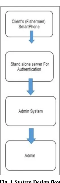
The figure 1 describes the system design flow, the whole system comprises of three modules. They are:
• Client Module, which is the smart phone application at the fishermen / users´end.
• Server module, a standalone server made from Raspberry Pi for authenticationand security purposes.
• Administrator’s system module, to monitor and control the client’s activity.
International Journal of Innovative Technology and Exploring Engineering (IJITEE) ISSN: 2278-3075, Volume-8 Issue-12, October 2019
Fig. 1 System Design flow
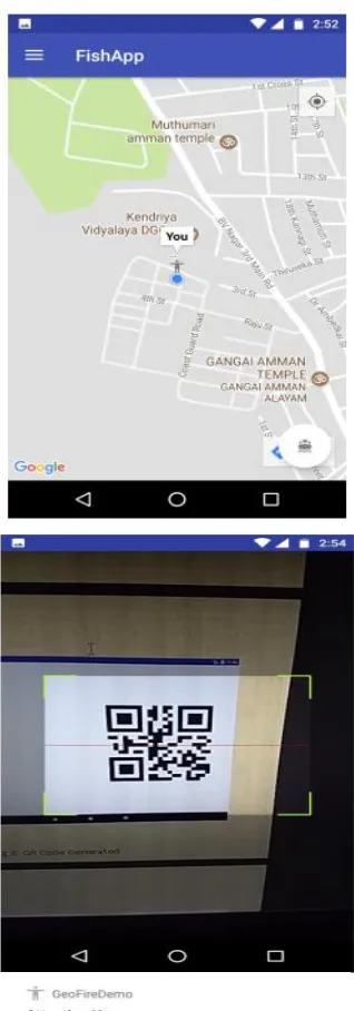
Client Application
This is the client application which helps the clients to receive alerts when they reachthe borders of international
waters with the help of geofencing while
simultaneouslysharing their GPS coordinates to the administrator by continuously updating the valuesin the real-time database at a specific real-time interval. The application also gives warning sound alerts from the phones speaker if the user / fisherman is about to approach or has ´crossed the sea border.The client application uses the phone’s camera as a QR code scanner which scans theQR code generated by the Pi Server and if the code matches with the IMEI of the registered device then the person is authorized to enter the sea or exit the previous fishingactivity.
Server Module
A standalone server is made to ensure authorized entry and exit in the harbour and sea waters. This server is built using a Raspberry Pi connected to the firebase real-timedatabase which generates a QR code of the IMEI number of the client’s handset withthe help of a pin allotted to the handset while registering in application. The Pi acceptsthe user’s 5 digit pin and if the pin matches with the pin registered in the database, it will return a QR code representing the encoded IMEI number which will be furtherused for scanning and authentication.
Administrator System Module
The Administrator system module has control over all the systems. It utilizes a webinterface with Google Maps API to track and monitor the location of each fishermenand also maintain a real time database for observing their travel logging time. Each time a fisherman enters or exits the harbour their data is logged in the real -time database
thereby easing our task of identifying the missing fishermen during emergency search and rescue operations (if any) and provide the victim’s personal data suchas name, age etc along with their last known location. The administrator system module also consists of a separate page which contains a list of joining requests for each fishermen who has registered. This gives the administrator the authority to validate and verify the identity of the fishermen by analysing their personal identification documents (AADHAR) submitted during the registration process and can grant them the access to use the application if the submitted documentsare found to be genuine. When this procedure is completed, the User’s Private Pin will be generated and given to the user. The pin will be generated if and only if theadministrator approves their joining request.
V. WORKING PRINCIPLE
Fig. 2 Registration forms
International Journal of Innovative Technology and Exploring Engineering (IJITEE) ISSN: 2278-3075, Volume-8 Issue-12, October 2019
VI. FUTURE ENHANCEMENTS
• Implementing appropriate Machine Learning algorithms to teach a system thedaily fishing patterns of all the domestic vessel to identify irregularities therebyclassifying between native and non-native vessels activities.
• Provide an easier interaction interface between the fishermen and the appropriategovernment agencies. i.e; Customer Support Enhancements.
• Native Language Support for both application texts as well as vocal warningalerts.
• Use of Facial Recognition along with the User’s Private Pin and QR Code Scanning procedure to enhance security measures.
• Provide easier ways of broadcasting SOS messages from client side to the administrator and appropriate agencies for assistance through the application.
VII. CONCLUSION
We can state that with the existing technology it is difficult to identify, track and locate a fishing boat or any domestic vessel offshore by the means of RADAR / Satellitebased optimized search for vessels near victim vicinity, or by sending distress signalsuch as Emergency Positioning Indicating Radio Beacon (EPIRB), Search and Research Transponder (SART) since these methods are proven to be costly and hence it is nearlyimpossible for the government to completely monitor the coast line and track each andevery position of the fishermen going into the sea.With our proposed model, we can track the location of the boats up to 10 - 15 milesfrom off coastline by simply tracking the GPS location of their smart phones which canfurther be extended by using signal repeaters, almost doubling the range. This methodis feasible and cost effective because of the abundant use of smart phones with GPSbased location services enabled in them.With our system we can ensure to easily track the number of people entering the seaand coming back to the shore with the date and time log of entering and exiting theharbour, hence it is easy to identify the missing native personnel’s or illegal immigrant’s activities. The entire security is based on User’s Private Pin which is unique to eachuser, once authorized it generates a personal QR code on the server which activates orends the trip only when scanned using the application with the registered handset.
REFERENCES
1. Arunvijay, D. and Yuvaraj, E. (2014). “Design of border alert system for fishermen using gps.” International Journal of Students’ Research in Technology & Management, 2(2), 67–70.
2. Bharavi, U. and Sukesh, R. M. (2017). “Design and development of gsm and gps tracking module.” Recent Trends in Electronics, Information & Communication Technology (RTEICT), 2017 2nd IEEE International Conference on, IEEE. 283–288.
3. Bilgic, H. T. and Alkar, A. Z. (2011). “A secure tracking system for gps-enabled mobile phones.” Information Technology and Multimedia (ICIM), 2011 International Conference on, IEEE. 1–5.
4. Choi, S.-G., Chimeddorj, G., Altankhuyag, B., and Dunkhorol, S. (2016). “Design and implementation of a gps-enabled mobile wireless sensor network for livestock herd tracking in mongolian nomadic herding.” Strategic Technology (IFOST), 2016 11th International Forum on, IEEE. 423–427.
5. Dhinakaran, K., Srinath, S., Sriram, S., and Venkateshwar, R. (2017). “Gps based tracking system for transit objects.” Science Technology
Engineering &Management (ICONSTEM), 2017 Third International Conference on, IEEE. 194–201.
6. Hofmann-Wellenhof, B., Lichtenegger, H., and Collins, J. (2012). Global positioning system: theory and practice. Springer Science & Business Media.
7. Hu, P., Guo, Q., Yuan, C., and Zhang, X. (2011). “Design and implementation of 1.6 ghzepirb antenna.” Cross Strait Quad-Regional Radio Science and Wireless Technology Conference (CSQRWC), 2011, Vol. 1, IEEE. 429–432.
8. Prabakaran, K., Kumar, N. R., Punitha, G., Asmi, S., and Paulchamy, B. (2013). “A noval approach of geofencing and geotagging system based sea border identification using embedded system.” Current Trends in Engineering and Technology (ICCTET), 2013 International Conference on, IEEE. 338–341.
9. Reclus, F. and Drouard, K. (2009). “Geofencing for fleet & freight management.”Intelligent Transport Systems Telecommunications, (ITST), 2009 9th International Conference on, IEEE. 353–356. 10. Sanqunetti, D. R. (2006). “Implementing geo-fencing on mobile
devices. US Patent 6,983,202.
11. Shah, A. T. and Parihar, V. R. (2017). “Overview and an approach for qr-code based messaging and file sharing on android platform in view of security.” Computing Methodologies and Communication (ICCMC), 2017 International Conference on, IEEE. 371–373.
12. Sharma, K. P., Poonia, R. C., and Sunda, S. (2017). “Map matching approach for current location tracking on the road network.” Infocom Technologies and UnmannedSystems (Trends and Future Directions)(ICTUS), 2017 International Conference on, IEEE. 573– 578.
13. Watkins, J., Kitner, K. R., and Mehta, D. (2012). “Mobile and smartphone use in urban and rural india.” Continuum, 26(5), 685–697. 14. Zhu, X. (2016). “Design of a gps-based mobile application for campus