Abstract: In the last 10 years, scientists developed numerous indoor navigation systems but most of these systems are operated in robotic area. But due to the significant advance in technology, large number of smart devices developed. This phenomenon draws massive intention to human navigation topic. As a result, numerous indoor navigation systems for human have been developed and practiced in many research areas, for example marketing, asset management and tracking, security and so on. Disaster management is one of them, we can reduce casualties in emergency circumstances. In this paper, we propose an indoor navigation mechanism on smart devices combining map building and path planning techniques. The semantic map technique is adopted in this work to solve the map building task. This approach also comes in handy when deals with path planning task. Besides that, A* method is used to find the shortest path. The proposed method can be applied to help people in disaster situations.
Index Terms: human navigation, indoor navigation, disaster situation, path planning, semantic map.
I. INTRODUCTION
To go from places to place, people can realize where are they and imagine different way to reach destination in their minds. The thing is, with each person, they have varied approach to plan the route. By that reason, we can deduce that there are many navigational strategies. In general, the process of human navigation in both indoor and out environments usually estimated the direction and distance of human to various referencing points. The navigation system has to incorporate at least a map and a localization technique to determine human’s position and orientation. In addition, a navigation system manager to provide the directions from the human’s present location to final place. This includes path planning and represent it as obvious and simple as possible. Regular tasks of indoor navigation are detecting human’s position and places in buildings like offices, university or mall. Because of that, in the last few years, large number of scientists have gained significant progress in the development of map building techniques. In the robot
Revised Manuscript Received on May 22, 2019.
Ngo Hai Linh, Master Student, Computer Science, Sun Moon University, Korea.
Park Yoon Young, Professor, Computer Science, Sun Moon University, Korea.
Luong Tien Manh, Master Student, Computer Science, Sun Moon University, Korea.
Kim Se-Yeob, Ph.D. Student, Computer Science, Sun Moon University, Korea.
Lee Kyung-Oh, Professor, Computer Science, Sun Moon University, Korea.
navigation task, a mobile robot gathers information with sensors while moving around environment and creates a map. The maps are later used for localization and navigation tasks. There are various ways to build a map. Most of them focus on capturing the metric layout or topological structure of environment. The metric map represents environments by regularly spaced grids. For example, each grid cell demonstrates the presence of an obstacle in the appropriate environment region. Different with grid-based approaches, topological map segments space into individual areas that are connected to each other by paths.
However, the map of robot is not always simple to understand in human perspective. To meet these requirements, the map needs semantic information which human can better understand the environment when reading the map. Thus, in a building, the accuracy of positioning must be at the level of room and the floor must be properly identified. The main goal of semantic mapping is adding information, remarkable points also the symbols that contain meaningful concepts for humans like corridors, rooms, doorways. This semantic map has capability to accomplish in many applications. For instant, the communication between human and robot, make environmental easier to understand and have more information, or in combination with localization and path-planning.
For localization, the Global Positioning System (GPS) and other developed Global Navigation Satellite Systems (GNSS) provided incomparable precision and efficiency to outdoor navigation applications. As a consequence, GNSS has outstanding evolved over the last decade. Since GNSS or Assisted GNSS receiver is applied in every smartphone, outdoor navigation with smartphones appeared everywhere. However, in indoor navigation, there is more complex issues, like signals is blocked or reflected and error ranges that are often larger, that make GNSS unsuitable for indoor environments. Instead of GPS, indoor navigation most use some common methods including dead reckoning, beacon or sensor-based approaches. Furthermore, there are several indoor navigation technologies are suitable to implement on smart devices (smart phone, smart watch and so on), for example: use of radio frequency, self-contained sensors, indoor map (building floor plan), magnetic field fingerprinting [1]-[3].
For path-planning, the overall performance of the
navigation system is
influenced by this task. The path needs to be convenient
A Comparative Study on the Implementation an
Efficient Indoor Navigation using Smart
Devices in Disaster Situations
Published By:
and effective. Pathfinding is strongly linked to the shortest path problem, which examines how to identify the path that
[image:2.595.58.533.76.352.2]the distant between two points is shortest. This issue is the main topic of the current path-planning task.
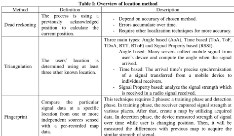
Table I: Overview of location method
Method Definition Description
Dead reckoning
The process is using a previously acknowledged position to calculate the current position.
- Depend on accuracy of chosen method. - Errors accumulate over time.
- Require other localization techniques for more accuracy.
Triangulation
The users’ location is determined using at least three other known location.
Three main types: Angle based (AoA), Time based (ToA, ToF, TDoA, RTT, RToF) and Signal Property based (RSSI)
- Angle based: Many servers collect mobile signal from user’s device and compute the angle when the signal arrived.
- Time based: The arrival time’s precise synchronization of a signal transferred from a mobile device to individual receivers.
- Signal Property based: analyze the signal strength which is received in a radio signal received.
Fingerprint
Compare the particular signal data at a specific location from one or more independent sources sensed with a per-recorded map data.
This technique requires 2 phases: a training phase and detection phase. In training phase, the receiver captured signal strength at various places. After that, create a map by utilizing acquired data. In detection phase, the device measured strength of signal over time while user is changing position. Then, it will be measured the differences with previous map to acquire the similar strength of signal.
Especially when disaster situation occur, human has limited time to evacuation before the condition is getting worse.
In this research, we design a system that display evacuation path on smart device when disaster situation occurs. First, we introduce the semantic approach which creates the semantic map. This semantic map was made by using simulated range data from geometric maps. Later, based on semantic map, we calculate the escape path in disaster situation.
The remainder of this paper is organized as follows. The next section is discussion about the previous research in the field of indoor navigation and path planning. The section 3 outlines the procedure of our system in detail. The section 4 brings the conclusion and researches that we focus on in the future. Section 5 and 6 is acknowledgment and references.
II. RELATEDWORK
In this chapter we introduce an analysis of map building techniques together with indoor navigation method for human.
A. Map building
Mapping is a technique to create a map which represent surround environment. In the paper, several methods have been presented. In this section, four popular types of map are briefly explained: architectural floor plans, distance transform-based, feature-based and Voronoi graphs.
To begin with, a group of methods simplify architectural floor plans. [10], [11] and [16] discuss about a system that adopt architectural layout with all definite letter and description. They detect walls in map by operating line detection for dividing individual rooms. Then, a grid map is produced by those lines and the room name adopt from the
architectural plan. [12] debate a comparable system which operates Canny edge detection to find walls and Hough transform to separate the floor plan.
Secondly, the distance transform serves as the length between individual available pixel and the nearest boundary pixel. This length produces local maxima and when the distance is maximum, the cell stays on middle point of two boundary pixels. Therefore, all the cells around that point belong to one individual place [13], [14]. After the mapping has been completed, the distance transformation cluster cells in map into individual place and combine them to the nearest label.
In the third is the room segmentation technique based on feature. The laser scanner data, which is the simulated 360º rays of each pixel in the grid map, is used to classify the feature. Thus, using machine learning to classify cells into room or hallway and all cells which are neighbor and have an identical label are merged [15].
The final is Voronoi graph which is the most popular method. The generation of Voronoi diagrams seeks to discover every point on the map that where the distance to the obstacles is maximum. So that when follow this diagram, we always avoid all the obstacles in map. In this way, the diagram is defined as the locus of the configurations that are at the same distance from the obstacles. [4]-[6].
B. Navigation
In navigation system, there are three major components: localization, path planning and represent. To satisfy localization, Indoor Positioning System (IPS) has been invented. By definition in
a person or an object real time in a small environment. To measure position, IPS uses some methods that can be grouped into four different techniques: using inertial and motion sensors, direct sensing, wireless communication technologies and pattern recognition. Table 1 gives an
overview of location methods [1]-[3], [17]-[20].
Path-planning algorithms represent the environment using graphs or grids layout. In graph-based approaches, the map is split into many areas (nodes) and edges attaching
Fig. 1: Example of range data in (a) room, (b) doorway and (c) hallway
these nodes. In the grid-based case, the map is represented by grid coordinates with each small cell has information of the objects at that place and the detail of the environment. Because sometime human may ignore the paths, the system might have ability to relocate the new position of human and then planning new route. However, only a few human navigations system provide re-planning feature. Almost human navigation systems appear to mainly concentrate on finding the position of human and allows users to travel around the environment at their own will. However, in disaster situation, the final goal is to provide evacuation route.
III. METHODOLOGY
Due to simplicity, this research’s target is constructing a map, path planning and display evacuation route. To build our map, total 5 steps need to be processed: map preprocessing, map segmentation, feature extraction, and map labeling.
First, the map is refined in order to remove all ambiguous obstacles from raw map and makes the map more similar the floor plan. Secondly, the free space of map is segmented into many partitions. The Voronoi graphs is One of the most famous strategies that use to divide the map. The particular way to generate Voronoi graphs using grid maps is outlined in [4], [5]. The main propose is using local and neighboring information to conclude the label of every free cell on the occupancy grid. By local information, we mean the simulated 360º rays of each pixel in specific location. Which mean the grid map was constructed first, thereafter, the grid map is separated into different regions through critical points. Then, the different regions are applied to generate a topological map.
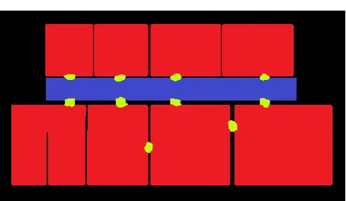
Fig. 2: The outcomes of categorization produced through the application of the classifier learned from the map.
Based on [6], there are 3 main kinds of critical points in semantic map as hallway, room and doorway. Furthermore, each region has a different structure (Fig. 1). For instant, the shape of rooms seems to be more cluttered than the hallways. These structural differences persuade further use of learning methodologies to acquire systems for place classification. Hence, our works carried out SVM classifiers with basic laser sensor components, related to [7][8]. Fig. 2 show the map after segmented where red areas are room, blue is hallway and yellows are doorway.
Finally, from there on, we use a probabilistic method of relaxation labeling first brought in by [9] to create a labeled topology map (Fig. 3). Relaxation labeling is a methodology for image processing. Its aim to identify a label with a given image's pixels or nodes of a given graph. Thus, labeled topology map will use to support the path planning task.
To calculate escape path, we build tree-based model using labeled topological map (Fig. 4). A* method was used in this paper to find the shortest path. A* is an algorithm commonly used in the search for paths and graphs. This algorithm optimally traces an available path on the graph between multiple nodes or points. Starting with a particular node in graph map, it seeks to create
[image:3.595.61.539.119.258.2] [image:3.595.306.551.276.418.2]Published By:
path which started from exit node are computed and the goal node is each room node.
Fig. 3: Labeled topological map. The rooms and the doors are enumerated with regard to the map, from left to right and
from top to bottom.
Fig. 4: Illustrate labeled topological map and tree-based escape path.
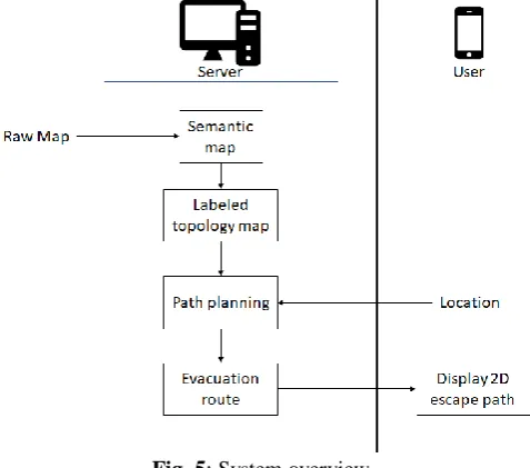
IV. SYSTEMOVERVIEW
In the past, there are a lot of human navigations system proposed. Most of them focused on accomplishing accuracy as high as possible. However, human is able to identify the surround area. Our basic plan is to take advantage of human mind, instead of depending on the detail information come from the map. When guiding someone through a building, it is not necessary to show how many steps they have to take before reaching the destination. Instead of that, the information they need is the evacuation route and distance to the exit.
Fig. 5: System overview
Our system aims to provide a map easy to interact with human and the help them to find the best evacuation route. Fig. 5 shows the process of proposed navigation system. During the map building phase, the machine will collect meaningful environmental information (raw map). Data can be collected from a robot or a team of robots moving around
environments. Next, the server uses map building technique which was explained in the last section to create a labeled topological map and tree-based model.
During the navigation phase, user’s device communicates with server and sends position to server. Based on the semantic map, the nearest note to user’s position becomes user’s note in labeled topological map. The server will calculate the shortest path to exit note. When the disaster occurs, server sends back the evacuation route to user’s device. 2D map (Figure 6) is used to display escape path on smart devices.
Fig. 6: Representing the evacuation route on 2D map.
V. CONCLUSION
This paper proposes an indoor navigation system, which guides human to exit door in emergency circumstances using smart device. While recognizing human knowledge as an important input, proposed system is able to use labeled topological map and calculate the shortest path. However, the system still has some drawbacks such as how user’s device and sever communicate or how user’s position is measured. In the future work, we will investigate more to solve all of these drawbacks and develop
[image:4.595.36.551.87.283.2] [image:4.595.305.551.455.582.2] [image:4.595.51.290.475.685.2]human.
ACKNOWLEDGMENT
This work was supported by National Research Foundation of Korea Grant Funded by the Korean Government (NRF2016R1A2B4014223).
REFERENCES
1. F. Zafari, A. Gkelias, K.K. Leung. A Survey of Indoor Localization Systems and Technologies. CORR. 2017.
2. Pavel Davidson and Robert Piche. A Survey of Selected Indoor Positioning Methods for Smartphones. IEEE Communications Surveys & Tutorials. 2017;19(2):1347-70.
3. A.G. Ferreira, D. Fernandes, A.P. Catarino, and J.L. Monteiro. Localization and Positioning Systems for Emergency Responders: A Survey. IEEE Communications Surveys & Tutorials. 2017;19(4):2836-70.
4. S. Fortune, Steven. A Sweepline Algorithm for Voronoi Diagrams. Algorithmica. 1987;2(1):153.
5. F. Karimipour and M. Ghandehari. A Stable Voronoi-based Algorithm for Medial Axis Extraction through Labeling Sample Points. Ninth International Symposium on Voronoi Diagrams in Science and Engineering. 2012:109-14.
6. R. Bormann, F. Jordan, W. Li, J. Hampp, M. Hagele. Room Segmentation: Survey, Implementation, and Analysis. ICRA. 2016:1019-26.
7. P. Sousa, R. Araújo, U. Nunes. Real-Time Labeling of Places using Support Vector Machines. IEEE International Symposium on Industrial Electronics. 2007:2022-27.
8. R. Goeddel and E. Olson. Learning semantic place labels from occupancy grids using CNNs. IROS. 2016:3999-4004.
9. A. Rosenfeld, R.A. Hummel, S.W. Zucker. Scene labeling by relaxation operations. IEEE Transactions on Systems, Man, and Cybernetics. 1976; SMC-6(6):420-33.
10. S. Ahmed, M. Liwicki, M. Weber, A. Dengel. Automatic Room Detection and Room Labeling from Architectural Floor Plans. 10th IAPR International Workshop on Document Analysis Systems. 2012:339-43. 11. LP. Heras, S. Ahmed, M. Liwicki, E. Valveny, G. Sanchez. Statistical
segmentation and structural recognition for floor plan interpretation. IJDAR. 2014;17(3):221-37.
12. R. Capobianco, G. Gemignani, D. D. Bloisi, D. Nardi, and L. Iocchi. Automatic extraction of structural representations of environments. AISC. 2016;302:721-33.
13. E. Topp and H. Christensen. Detecting Region Transitions for Human-Augmented Mapping. IEEE Transactions on Robotics. 2010;26(4):715-20.
14. C. Nieto-Granda, J. Rogers, A. Trevor, and H. Christensen. Semantic map partitioning in indoor environments using regional analysis. IEEE/RSJ International Conference on Intelligent Robots and Systems. 2010:1451-56.
15. O. M. Mozos. Semantic Labeling of Places with Mobile Robots. STAR. 2010;61.
16. R. Ambrus, S. Claici, A. Wendt. Automatic Room Segmentation from Unstructured 3D Data of Indoor Environments. IEEE Robotics and Automation Letters. 2017;2(2):749-56.
17. Y. Gu, A. Lo, and I. Niemegeers. A survey of indoor positioning systems for wireless personal networks. IEEE Communications Surveys & Tutorials. 2009;11(1):13-32.
18. D. Zhang, F. Xia, Z. Yang, L. Yao, and W. Zhao. Localization Technologies for Indoor Human Tracking. 5th International Conference on Future Information Technology. 2010:1-6.
19. C. Fuchs, N. Aschenbruck, P. Martini, M. Wieneke. Indoor tracking for mission critical scenarios: A survey. Pervasive and Mobile Computing. 2011;7(1):1-15.