Tectonics of Central and Eastern California,
Late Cretaceous to Modern
Thesis by
Francis Joseph Sousa
In Partial Fulfillment of the Requirements for the degree of
Doctor of Philosophy
CALIFORNIA INSTITUTE OF TECHNOLOGY Pasadena, California
2016
2016
ACKNOWLEDGEMENTS
The last five years at Caltech have left me with a very long list of creditors, and folks
who need to be thanked. I have to thank all the members of my thesis committee for letting
me pursue, in my own way, so many diverse geologic problems. I also thank them for letting
me take advantage of the many field experiences that have been available to me, including an
enrichment trip to the Cyclades, the Pahoehoe trip, and over 20 Ge 136 trips around the
Southwest. It all started when Joann Stock called me up in late December 2010 and offered to
buy me an airplane ticket to come down to the Imperial Valley and work on the Salton Seismic
Imaging Project field team. Jean-Phillipe Avouac has been a truly outstanding academic
advisor, always helping keep me on track. Joe Kirschvink, the benefactor of Ge 136,
welcomed me to his lab, taught me about my own sixth sense, and has always been there to
bring a smile to my face with a Buck Turgidson quotation.
Ken Farley opened the doors of his lab to me, was always willing to talk Sierras, and
trusted me with the plastic wrapped tweezers. His professional guidance has made me who I
am today. When I came to Caltech I was unguided and adrift. I remember the first field trip I
went on with Jason Saleeby, it was Ge 195, special study of the San Gabriel Mountains. The
last stop of the trip was an exposure of the San Gabriel fault, and Jason told us a story about
how a guy named Joseph Campbell used the language of mythology to convey a concept
central to the field of geology, deep time versus perceived time. At that moment I knew I was
a geologist. Ever since then, Jason has helped me become a better one.
My fellow GPS students have made my life at Caltech joyful. I couldn’t have made it
Bergmann, Paul Magyar, and many others. My roommates Ted Present, Steve Skinner, and
Vinny Biasi have always been there for me during grill season, when I needed someone to
complain to, if I needed to make twenty-one decisions, or if I needed to learn how long a
human being could stand in a wet swimsuit on the deck of an ice breaker with wind chills at 40
below. Everyone who ever went on a Ge 136 trip with me, especially Sarah Slotznick, knows
that now is the time to Turn Your Radio On. Thanks to the entire Farley group, especially
Stephen Cox, Hayden Miller, Peter Martin, Flo-Ho, and Thiago Piacentini, and to all my pit
mates for their friendship over the years. Renata Cummins, Jen Hamon, Luca Malatesta, Jason
Price, Adam Subhas, Sophia Hines, Ted Present, Vicky Stevens, and Kirsten Siebach. All of
the inhabitants of the French Quarter and my office mates over the years: Sylvain Barbot,
Kristel Chanard, Creek Quinn, Erika Swanson, Vicky Stevens, Ryan Witkosky, Francois
Ayoub, Christoph van Hagke, Nadaya Cubas, and Chris Rollins.
The GPS division staff have found a way to simultaneously make my job easier and
cheerfully share in the day to day grind. Dian Buchness, Liz Boyd, Marcia Hudson and Janis
Grancich were always there for me when I needed a snack break or help with any number of
infinite work related tasks. Terry Gennaro taught me to shoot first and ask questions later, and
to beware of law enforcement lurking in the dark shadows. Mark Garcia very graciously
ordered four new tires for the truck when I had a blow out at 80 mph on the Grapevine, and
new division radios after having a series of critical radio failures, culminating at a beach cliff in
Mexico. Lisa Christensen was always available when I needed help with Arc. Thank you,
I am especially thankful to my friends and family for their patience and support over
the last five years, and to my better half, JC Creveling, for always being there for me.
Finally, I want to thank Lindsey Hedges, who gave me so much over the years, least of
which was her masterful instruction in laboratory techniques. Her friendship, brightness,
Easter candy, and spot-on George Rossman impressions will always stay with me. Nothing
Lindsey gave me can ever be lost. She is with me every day, now more than ever.
ABSTRACT
The Late Cretaceous to Modern tectonic evolution of central and eastern California
has been studied for many decades, with published work generally focusing on specific
geographic areas and time periods. The resulting literature leaves the reader, whether graduate
student, faculty member, or layperson, wondering what a coherently integrated tectonic
evolution might look like, or if it would be at all possible to undertake such a task. This
question is the common thread weaving together the four studies presented in this work.
Each of the individual chapters is targeted at a specific location and time period which I have
identified as a critical yet missing link in piecing together a coherent regional tectonic story. In
the first chapter, we re-discover a set of major west down normal faults running along the
western slope of the southern Sierra, the western Sierra fault system (WSFS). We show that
one of these faults was offset by roughly a kilometer in Eocene time, and that this activity
directly resulted in the incision of much of the relief present in modern Kings Canyon. The
second chapter is a basement landscape and thermochronometric study of the hanging wall of
the WSFS. New data from this study area provide a significant westward expansion of
basement thermochronometric data from the southern Sierra Nevada batholith. Thermal
modeling results of these data provide critical new constraints on the early exhumation of the
Sierra Nevada batholith, and in the context of the results from Chapter I, allow us to piece
together a coherent chronology of tectonic forcings and landscape evolution for the southern
Sierra Nevada. In the third chapter, I present a study of the surface rupture of the 1999
Hector Mine earthquake, a dextral strike slip event on a fault in the Eastern California Shear
Zone (ECSZ). New constraints on the active tectonics in ECSZ will help future studies better
regional rates. Chapter IV is a magnetostratigraphic pilot study of the Paleocene Goler
Formation. This study provides strong evidence that continued investigation will yield new
constraints on the depositional age of the only fossil-bearing Paleocene terrestrial deposit on
the west coast of North America. Each of these studies aims to provide important new data at
PUBLISHED CONTENT AND CONTRIBUTIONS
Sousa, F. J. et al. (2016). “Eocene activity on the Western Sierra Fault System and its role
incising Kings Canyon, California”. In: Earth and Planetary Sciences Letters v. 439, pp. 29-38.
doi: 10.1016/j.epsl.2016.01.020.
F.J.S. undertook field work to confirm the central hypothesis of the study, completed the
TABLE OF CONTENTS
Acknowledgements ... iii
Abstract ... vi
Published Content and Contributions ... viii
Table of Contents ... ix
List of Figures ... xii
Introduction ... 1
Chapter I: Eocene activity on the Western Sierra Fault System and its role incising Kings Canyon, California Abstract ... 5
Introduction ... 6
Overview of the problem ... 8
Material and methods ... 11
Ap-He data ... 15
Fault identification ... 17
Thermochronologic modelling ... 19
Discussion ... 22
Conclusions ... 26
Acknowledgements ... 27
References ... 29
Figure and table captions ... 34
Chapter II: The southern Sierra Nevada pediment, central California
Abstract ... 59
Introduction ... 60
Geologic setting ... 61
Previous work ... 63
Methods ... 67
Data presentation ... 72
Results of thermal modelling ... 78
Discussion ... 79
Conclusions ... 88
Acknowledgements ... 90
References ... 90
Figure captions ... 102
Appendix B ... 118
Chapter III: Re-evaluating offset measurements in the maximum slip zone of the 1999 Hector Mine earthquake surface rupture Abstract ... 150
Introduction ... 150
Data and methods ... 154
Results ... 159
Discussion ... 163
Data and resources ... 182
Acknowledgements ... 182
References ... 183
Tables ... 149
Figure captions ... 194
Appendix C ... 207
Chapter IV: A magnetostratigraphic pilot study of the Paleocene Goler Formation, El Paso Mountains, California Abstract ... 218
Introduction ... 219
Geologic setting ... 220
Methods ... 222
Results ... 225
Discussion ... 226
Conclusions ... 228
Acknowledgements ... 229
References ... 229
LIST OF FIGURES
Introduction
Figure 1 ... 4
Chapter I: Eocene activity on the Western Sierra Fault System and its role incising Kings Canyon, California Figure 1 ... 37
Figure 2 ... 38
Figure 3 ... 39
Figure 4 ... 40
Figure 5 ... 41
Figure 6 ... 42
Figure 7 ... 43
Figure S1 ... 53
Figure S2 ... 54
Figure S3 ... 55
Figure S4 ... 56
Figure S5 ... 57
Chapter II: The southern Sierra Nevada pediment, central California Figure 1 ... 107
Figure 2 ... 108
Figure 3 ... 109
Figure 4 ... 110
Figure 6 ... 112
Figure 7 ... 113
Figure 8 ... 114
Figure 9 ... 115
Figure 10 ... 116
Figure 11 ... 117
Figure S1 ... 121
Figure S2 ... 122
Figure S3 ... 123
Figure S4 ... 124
Figure S5 ... 125
Figure S6 ... 140
Figure S7 ... 141
Figure S8 ... 142
Figure S9 ... 143
Figure S10 ... 144
Figure S11 ... 145
Figure S12 ... 146
Figure S13 ... 147
Chapter III: Re-evaluating offset measurements in the maximum slip zone of the 1999 Hector Mine earthquake surface rupture Figure 1 ... 198
Figure 3 ... 200
Figure 4 ... 201
Figure 5 ... 202
Figure 6 ... 203
Figure 7 ... 204
Figure 8 ... 205
Figure 9 ... 206
Figure S1 ... 212
Figure S2 ... 213
Figure S3 ... 214
Figure S4 ... 215
Figure S5 ... 216
Chapter IV: A magnetostratigraphic pilot study of the Paleocene Goler Formation, El Paso Mountains, California Figure 1 ... 237
Figure 2 ... 238
Figure 3 ... 239
Figure 4 ... 240
Figure 5 ... 241
Figure 6 ... 242
I n t r o d u c t i o n
California is one of the most geologically diverse places on Earth. Geologists have
long striven to understand such features as the Sierra Nevada Mountains, the Great Valley
basin, the Mojave Desert plateau, and the San Andreas Fault. Over the last 50 years our
knowledge of the kinematic history and dynamic forcings responsible for the genesis and
evolution of these regional features has mimicked global advancements in the earth sciences.
With the dawn of the plate tectonic paradigm the San Andreas fault was understood to be a
major plate boundary transform fault. The development of U-Pb geochronology allowed
researchers to determine that the Sierra Nevada batholith was formed by a magmatic arc which
migrated eastward during Cretaceous time. Geophysical advancements led to several
fundamental discoveries including that the deepest part of the Great Valley basin is underlain
by one of the largest vertically oriented blobs of anomalously high velocity upper mantle
material on Earth, and that the highest parts of the Sierra Nevada Mountains are underlain by
30 km thick crust. The inception of (U-Th)/He thermochronometry and igneous
geobarometry allowed for the discovery that the southernmost Sierra Nevada and Mojave
segments of the Cretaceous arc were very rapidly exhumed to extreme depths (greater than 30
km) shortly before the cessation of arc magmatism about 85 million years ago.
The progressive development of a regional geologic framework for the geologic
evolution of California has resulted in a complex set of individual studies of varied geographic
extent. Some of these studies claim to disagree with others, and some claim to integrate
explanation of how each fits into a coherent regional framework. With this in mind, I
undertook the studies presented in this thesis (Figure 1).
Chapter I utilizes apatite (U-Th)/He (Ap-He) data and apatite 4He/3He data along with a newly available software package which applies a Bayesian Monte Carlo Markov Chain
inverse thermal modelling approach. In this study we re-discover a kilometer-scale west-down
normal fault cutting across Kings Canyon, California, and conclude that Eocene activity on
this fault was directly responsible for incision of roughly 80% of the relief in modern Kings
Canyon.
In Chapter II a new horizontal transect of apatite (U-Th)/He, Zr (U-Th)/He and Ap
4He/3He data are presented. This data is a fundamental contribution to the body of published basement thermochronometric data from the Sierra Nevada batholith, and includes the oldest
average Sierran Ap-He age ever published, from near Friant, California. Thermal modelling
results constrain Late Cretaceous rapid exhumation of the southern Sierra Nevada foothills
during the same time period when the southernmost Sierra Nevada – Mojave segment of the
Cretaceous arc was profoundly exhumed. This allows us to hypothesize a dynamic link
between these events, and to develop a chronology of tectonic forcings and landscape
evolution of the southern Sierra Nevada which is complete and consistent with all previously
published data.
Chapter III focuses on the Hector Mine earthquake surface rupture. This earthquake,
which shook southern California in October 1999, occurred on a series of dextral strike-slip
faults in the Eastern California Shear Zone (ECSZ). This zone of distributed right-lateral
shear is the central link between active oceanic rifting in the Sea of Cortez to the south, and
understanding the small-scale offsets across this surface rupture, we contribute to the body of
geologic offset data across the ECSZ, which are enigmatically mismatched with geodetically
estimated rates across the region.
In Chapter IV, we present a pilot magnetostratigraphic study of the Paleocene Goler
Formation, El Paso Mountains, California. Due to the paucity of Paleocene terrestrial
sediments in California, the Goler Formation is a critical datum for this time period. Despite
the very thick sedimentary accumulation (4,000 meters) of Goler Formation, the only good age
constraints published to date are from the upper member. By getting a magnetostratigraphic
foothold at a Tiffanian mammal fossil locality, we are able to tentatively calculate a sediment
accumulation rate for the Goler Formation. This pilot study strongly suggests that continued
magnetostratigraphic study of the Goler Formation will yield a better depositional age model
for the fossil-bearing Paleocene sediments and help to constrain the age of the lower part of
the section.
Each of these studies provides important regional geologic data. Together, these
studies aim to contribute to an integrated regional geologic understanding of the kinematic and
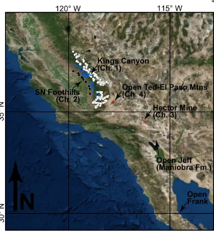
Figure 1. Regional overview map showing the locations of each of the Chapters of this thesis,
as well as the locations of three pig roasts, Open Ted (May 2015), Open Jeff (December 2015),
C h a p t e r 1
Eocene activity on the Western Sierra Fault System
and its role incising Kings Canyon, California
Francis J. Sousaa, Kenneth A. Farleya, Jason Saleebya, Marin Clarkb
aDivision of Geological and Planetary Sciences, California Institute of Technology, 1200 East California Blvd, Pasadena, California, 91125
bEarth and Environmental Sciences, University of Michigan, 1100 North University Avenue, Ann Arbor, MI, 48109
KEYWORDS
Apatite 4He/3He thermochronometry; Sierra Nevada tectonics; Kings River canyon incision; Bayesian Monte Carlo Markov Chain modeling
ABSTRACT
Combining new and published apatite (U-Th)/He and apatite 4He/3He data from along the Kings River canyon, California we rediscover a west-down normal fault on the western slope
of the southern Sierra Nevada, one of a series of scarps initially described by Hake (1928)
which we call the Western Sierra Fault System. Integrating field observations with apatite
(U-Th)/He data, we infer a single fault trace 30 kilometers long, and constrain the vertical offset
documents a pulse of footwall cooling near the fault and upstream in the footwall at circa
45-40 Ma, which we infer to be the timing of a kilometer-scale incision pulse resulting from the fault activity. In the context of published data from the subsurface of the Sacramento and San
Joaquin Valleys, our data from the Western Sierra Fault System suggests an Eocene tectonic
regime dominated by low-to-moderate magnitude extension, surfaceuplift, and internal
structural deformation of the southern Sierra Nevada and proximal Great Valley forearc.
1. INTRODUCTION
Distinguishing actively developing topographic features from landforms that evolved under earlier tectonic and climatic regimes is often a difficult, if not impossible, task. It has long been known that this challenge is confounded by changes in the climate system that can force cycles of erosion and aggradation. The more recent geodynamic realization that vertical displacement transients may migrate rapidly through regions due to redistributions in lower crust and upper mantle loads (Loomis and Glazner, 1986; Saleeby et al., 2013a) now adds additional complexity to the problem. This raises a number of fundamental questions: What controls the initial formation of a landscape? To what extent can early landforms influence topographic patterns forced under subsequent regimes?
We pursue these questions, which through a long history of studies have been posed for the
southern Sierra Nevada, California. We focus on the Kings River canyon (Kings Canyon),
which has the greatest local relief of all Sierra canyons, with maximum vertical relief of about
2,500 meters (vertical relief is about 2,000 meters at our study location). Previous studies argue
2001; Stock et al., 2004; Clark et al., 2005; McPhillips and Brandon, 2012; Pelletier, 2007).
However, important details of the earlier cycles, such as timing and relative magnitude, elude
us.
A three-dimensional array of apatite 4He/3He (Ap-4He/3He) and bulk apatite (U-Th)/He (Ap-He) data clarifies an early Cenozoic phase of southern Sierra landscape evolution. New Ap-He
data constrain a discrete, kilometer scale exhumation difference across a topographic step,
which we interpret as a west-down normal fault. This fault is one of a set running along the
western slope of the southern Sierra initially described by Hake (1928), andwas dismissed
(Wahrhaftig, 1965) and neglected in the literature for most of the last century. We herein
name this the Western Sierra Fault System (WSFS).
Bayesian Monte Carlo Markov Chain (MCMC) modeling of the thermal history of a sample
from just upstream of the inferred fault scarp constrains fault activity to be circa 45-40 Ma.
Additional thermal modeling of data from high relief topography of Kings Canyon east of the
fault, but below the region of clearly recognizable glacial erosion, indicates that this Eocene fault activity also corresponds to a kilometer-scale pulse of incision in the Kings Canyon. Data
and thermal modeling presented here elucidate an Eocene tectonic regime during which the
WSFS played a critical role in generating much of the relief present along the modern Kings
River. This analysis raises the question of the potential importance of similar early Cenozoic
activity on other scarps of the WSFS, which are identified along the length spanning from the
San Joaquin River to the Kern River (Hake, 1928), as well as the question of potentially
2. OVERVIEW OF THE PROBLEM
In the southern Sierra Nevada, deep fluvial canyons separate high elevation, low relief
interfluves. Together these geomorphic zones define regional longitudinal topographic profiles
marked by large amplitude (greater than 1 km), long wavelength (greater than 10 km) relief.
Debate over the timing of the generation of this regional relief lies at the core of an unsettled
question: How old are the southern Sierra river canyons?
Several diverse views summarize the current understanding of this issue. The first claims that
modern relief was generated primarily in late Cenozoic time. Several workers argue for this by
long distance extrapolation of limited geomorphic and stratigraphic data, which is only
available in the northern Sierra and its western foothills (Huber, 1981; Unruh, 1991;
Wakabayashi and Sawyer, 2001). Gabet (2014) discusses a number of weaknesses in the
conclusions of this view. The second concept utilizes horizontal transects of Ap-He data to
contend that longitudinal relief was greater in Late Cretaceous than at present (House et al.,
1998, 2001). A third idea argues for a rapid pulse of Plio-Pleistocene uplift and incision across
the central Sierra, documented by cosmogenic radionuclide burial dating of sediments
deposited on abandoned fluvial-cut cave terraces (Stock et al., 2004). Yet a fourth idea argues
for a significant pulse of mid-Cenozoic uplift and incision based on different datasets including
Ap-He data coupled to geomorphic analysis (Clark et al., 2005), a numerical landscape
evolution model integrating multiple data types (McPhillips and Brandon, 2012), and stream
incision data extrapolated from the northern Sierra combined with published
Despite the vast temporal and spatial differences amongst these concepts, they have been
generally treated as being in competition (e.g. is relief Late Cretaceous? or late Cenozoic?).
This approach confuses attempts to integrate the different models. However, none of the
concepts preclude the validity of the others. Thus we try to interpret these concepts as
complementary rather than competitive.
2.1 Previous work
The assumption of Cenozoic rigid-block behavior for the Sierra Nevada mountain range
underpins the analysis presented in several previous studies. Many of these studies explicitly
state this assumption, and some use its implications to extrapolate geologic data over long
distances and argue for late Cenozoic origin of most of the present-day topography,
particularly north of the Kings River canyon (Huber, 1981; Unruh, 1991; Wakabayashi and
Sawyer, 2001). This assumption of rigid behavior has also been extended westward into the
Great Valley, where sedimentation has been used to balance erosion of the southern Sierra
uplands during rigid west tilting (Wakabayashi and Sawyer, 2001).
On the other hand, vertical transects of Ap-He data from the southern Sierra show a
consistent age-elevation slope of 0.04 – 0.06 mm/year and lack clear inflections that would
record canyon incising events. This implies that the high elevation, low relief interfluvial
plateaus mimic the landscape that developed in the Late Cretaceous and was slowly exhumed
at roughly this same rate throughout the Cenozoic (Clark et al., 2005; Maheo et al., 2009,
along the axis of the central Sierra supports a Late Cretaceous antiquity of the large
amplitude, long wavelength longitudinal pattern (House et al., 1998, 2001; Braun 2002a,
2002b). Together these interpretations imply that low relief highlands and high relief canyons
were both part of the Late Cretaceous landscape. In this view, it has been argued that much of
the form of the modern landscape mimics regional Late Cretaceous geomorphology.
In contrast, Stock et al. (2004) identify a pulse of late Cenozoic river incision across the central
Sierra using cosmogenic radionuclide burial dates from vertical transects of quartz-bearing
sediment deposited on abandoned fluvial-cut terraces in carbonate caves. These data resolve
late Pliocene to Pleistocene incision of the lowest 20% of total relief of several central Sierra
river canyons (approximately 400 m in Kings Canyon). As Stock et al. (2004) point out, the
question of the antiquity of the upper 80% of relief (approximately 1600 m in Kings Canyon)
is left unconstrained.
In another study, Clark et al. (2005) identify two knickpoints in stream long profiles of the
main trunks and tributaries of the Kings and Kern rivers and argue that these knickpoints
correspond to two pulses of incision responsible for most of the relief in these canyons. It is
asserted that these events must post-date the youngest Ap-He age on the Kings River (circa 32
Ma). Pelletier (2007) uses a numerical model to test different bedrock erosion models in the
southern Sierra, and the results of his preferred model (sediment-flux driven) indicate that the
southern Sierra Nevada experienced range-wide surface uplift in the latest Cretaceous and late
McPhillips and Brandon (2012) integrate published Ap-He and apatite fission track
thermochronometry, and aluminum-in-hornblende igneous geobarometric data into a
numerical landscape evolution model encompassing much of the modern Sierra. Their
preferred model finds onset of range-wide uplift and incision at circa 30 – 10 Ma.
Studies in the western foothills and eastern San Joaquin Valley subsurface report direct
measurements of minimum Paleogene paleo-relief. 500 meters of such minimum relief is
identified in the Kaweah River drainage near the Sierra-Great Valley transition based upon
interpretation of Ap-He data and bedrock pediment geomorphology (Saleeby et al., 2013b;
Sousa et al., 2013, 2014). Reid (1988) measures the same scale (500 m) of relief on the Upper
Cretaceous basement nonconformity in the San Joaquin Valley subsurface.
We next move on to presenting our new data and analysis from Kings Canyon. In the context
of the studies discussed above, we constrain an Eocene tectonicregimethat provides insights
into the early Cenozoic evolution of the southern Sierra. In doing so, we hope to move
toward a more complete story of southern Sierra Nevada landscapeevolution.
3. MATERIAL AND METHODS
3.1 Analytical methods
Samples were taken from outcrops of felsic granitoids of the Sierra Nevada Batholith along the
North Fork Kings River, the main trunk of the Kings River, and near the confluence of the
Middle and South Forks of the Kings River (FIGURE 1). After crushing, sieving, and
from each sample for analysis. Euhedral grains were selected and checked to exclude any
grains with birefringent inclusions (examined with cross-polarized light and immersed in
ethanol). The dimensions of each grain were then measured and recorded. For each sample,
four to ten individual grains were first analyzed for bulk Ap-He age determination. A Pfeiffer
Prisma quadrupole mass spectrometer was used for measuring helium by isotope dilution with
3He. U, Th, and Sm concentrations were measured via isotope dilution on an Agilent 7500 ICP-MS (e.g. Farley, 2002). An alpha-ejection corrected age for each grain was calculated
using the Ft parameter based on the measured grain dimensions (after Farley et al., 1996).
For each sample chosen for 4He/3He analysis, additional grains were subjected to a fluence of 1015 protons/cm2 with an energy of 220 MeV at the Francis H. Burr Proton Therapy Center of Massachusetts General Hospital to make a uniform distribution of 3He (Shuster and Farley, 2004; 2005). Individual grains were picked using the same criteria as for bulk age
determination, with particular attention paid to the lack of birefringent inclusions. Each
individual grain was step-wise degassed using a halogen lamp as heat source (Farley et al,
1996). 4He and 3He were measured at each degassing step using either a MAP215-50 or GV-SFT sector field mass spectrometer. The Ap-He and Ap-4He/3He data used in our analysis are presented in TABLE 1 and SUPPLEMENTAL DATA.
Because isochrones (surfaces of equal cooling age) are not horizontal in the Sierra, but are
tilted, previous studies utilizing Ap-He data from the Sierra have made a correction to allow
samples taken at different distances from the range axis to be compared. This is done by
McPhillips and Brandon (2010) explicitly model isochronal tilt based on published Ap-He
data and conclude a larger tilt value of 3.4°. In general these studies have explained isochronal
tilting as the result of late Cenozoic tectonics, assuming rigid body behavior of the Sierra (none
of the tilting is due to local rotation) and original isochrone horizontality (none of the tilting is
due to tilt at time of cooling). Because of the proximity of all our data, particularly within the
individual vertical transects, this type of correction has only a minor effect on our study.
However we do apply a correction by measuring the distance of each sample to a line parallel
to the local axis of the southern Sierra, and then reversing a 2° down-to-the-west tilt according
to this measured distance. Modern elevation and tilt corrected elevation are both reported for
each sample in TABLE 1.
3.2 Ap-He and Ap-4He/3He data
Any single Ap-He age is generally compatible with a wide range of thermal histories. A
considerably more restricted range is permitted when a bulk Ap-He age is combined with a
4He rim-to-core concentration profile. This is because different time-temperature (t-T) paths result in significantly different 4He concentration profiles based on the time-integrated balance between alpha-particle in-growth and loss by both ejection and diffusion. This balance can be
conceptually grasped by considering the amount of time that the sample spent in the partial
retention zone (PRZ). For example, a sample that was in the PRZ for a relatively long time
will have a diffusively rounded 4He profile, whereas a sample that cooled rapidly would have a squarer 4He profile. The Ap-4He/3He method allows us to mine this 4He rim-to-core
3.3 QTQt Modeling
To extract t-T information from both bulk ages and 4He/3He spectra, we utilize the
thermochronologic modeling software, QTQt (Gallagher, 2012) to model thermal histories of
samples with Ap-He and Ap-4He/3He data. QTQt employs a trans-dimensional Bayesian (MCMC) statistical approach to find the best t-T paths for a sample by employing a large
number of iterative perturbations in t-T space (we use at least 106 iterations). After each perturbation, the proposed path is compared to the initial path and the better-fitting of the two
is chosen according to a specific acceptance criterion (Gallagher, 2012). The model converges
on the best fit t-T path through this process during what is referred to as the “burn in” period
(Gallagher, 2012). For each of our model runs the “burn in” period consists of at least 5 x 10⁵ iterations. After the model has converged on the best fit t-T path, we run a set of 5 x 10⁵ “post-burn in” model iterations which are used to document the distribution of best fit t-T
histories. The result of this “post-burn in” period is represented in the model outputs.
In addition to applying this iterative process to a single sample, QTQt is designed to
simultaneously apply this iterative process to find a set of most likely t-T paths comprising a
vertical transect. In doing so, QTQt employs a linear thermal gradient that can be prescribed
to be a fixed value, or allowed to vary with time.
For each model run we impose the same set of manually controlled thermal history
constraints. The age of youngest local plutonism at 86 Ma (Chen and Moore, 1982; Moore
and Nokleberg, 1992) is used as a high temperature constraint (650º C +/- 100º C, 86 Ma +/-
explore (85º C +/- 70º C, 90 Ma to present). A rough estimate of modern mean annual
surface temperature (20º C +/- 5º C) is also utilized. All of the input data are listed in TABLE
1 and SUPPLEMENTAL DATA.
4. AP-HE DATA
We present nine new Ap-He bulk ages ranging from 34.7 Ma to 64.6 Ma at modern day
elevations of 402 meters to 1426 meters above sea level. Five of these new Ap-He ages are
accompanied by 4He/3He spectra. In addition to these nine samples, we utilize three
published bulk Ap-He ages from House et al. (1998) and one published bulk Ap-He age from
House et al. (1997). The location of each of the samples is shown on FIGURE 1 and the
details are tabulated in TABLE 1. KR1, KR2, KR3, and KR4 comprise a vertical transect near
the confluence of the Middle and South Forks Kings River spanning modern day elevations of
660 m to 1430 m above sea level (ASL). At this location the total vertical relief is about 2,000
meters (Stock et al., 2004). KR5, KR6, and KR7 comprise a second vertical transect on the
North Fork Kings River spanning modern day elevations of 540 m to 1230 m ASL, and
together with KR8 and 13SS6, are located farther west, and at lower elevation than previously
published Ap-He data from the area. KR8 and 13SS6 are from within roughly 10 meters of
the modern river level of the main trunk Kings River. Because of the distance of some of our
samples from the fault (up to a few kilometers) we rule out the possibility that cooling due to
fluid flow rather than exhumation may play a role in our Ap-He data.
Several published datasets of bulk Ap-He data from the southern Sierra include vertical
mm/yr (House et al., 1997; 1998, 2001, Clark et al., 2005; Maheo et al., 2009). This
age-elevation relationship is generally invariant in time and space, and generally extends down to an
age of approximately 40 Ma; younger ages are very sparse. The slope of the age-elevation
relationship is interpreted to represent the regional long-term Cenozoic erosion rate (House et
al., 1997; 1998; Maheo et al., 2009; Clark et al., 2005). To compare our data with this regional
relationship we plot Ap-He age versus corrected elevation for each of the two new vertical
transects (FIGURE 2A, B). Because of its location close to KR 1-4, we include the high
elevation sample KC4 (from House et al., 1997). On both of the new vertical transects, the
higher elevation samples are in good agreement with the regional age-elevation relationship
discussed above, as shown by the slopes of the linear regressions shown on FIGURES 2A and
B. However, the lowest samples on both vertical transects (KR1, KR3, and KR7) clearly
deviate from this trend. This deviation is greatest on the KR5-7 vertical transect (FIGURE
2B), where the bulk Ap-He age of KR7 is 20 m.y. older than expected, and is older than either
of the Ap-He ages from higher elevations on the same transect (KR5 and KR6). On the
KR1-4 vertical transect the deviation of the low elevation samples is of lesser magnitude but in the
same direction, with the ages of KR1 and KR3 each about 5 m.y. older than expected
(FIGURE 2A).
These deviations from the expected age-elevation trend comprise a local breakdown of the
expected pattern of predominantly slow Cenozoic cooling. Furthermore, the large deviation
within the KR5-7 vertical transect suggests the possibility that a fault offsets it (e.g. Maheo et
al. 2009). In the next section we investigate the KR5-7 vertical transect for potential geologic
5. FAULT IDENTIFICATION
Field reconnaissance along the KR5-7 vertical transect led to the discovery of several
curvilinear, approximately northwest-striking, steeply west-dipping topographic steps. One of
these steps crosses the vertical transect between KR5-6 and KR7 and preserves approximately
100 meters of modern relief (FIGURE 3). Immediately to the east of the vertical transect is a
larger (500 m) topographic step, sub-parallel to the step crossing the vertical transect.
Considering the large offset in age-elevation space and the topographic step crossing the
vertical transect between KR5-6 and KR7, we infer this west dipping topographic step to be a
significant west-down normal fault at this location. In 1928, Hake studied the
geomorphology of the southern Sierra Nevada and interpreted a series of topographic steps as
west-down normal fault scarps stepping southward from the San Joaquin River to the Kern
River. Despite the descriptive detail and mapping with which Hake documents the fault
scarps, his study has been disregarded in the literature (e.g. Wahrhaftig, 1965).
In the vicinity of the Kings River canyon, Hake (1928) described a set of en echelon faults,
including one along the North Fork Kings River in the immediate vicinity of KR5-7, but the
map scale used by Hake (1928) does not allow for more precise location. We hypothesize that
the modern topographic step is an erosional remnant of a west-down normal fault which
intersects the KR5-7 vertical transect, and is responsible for the age-elevation offset between
5.1 Confirmation of a fault scarp with Ap-He data
We hypothesize that the age-elevation offset along the KR5-7 vertical transect is due to offset
on a discrete west-down normal fault. In this scenario, the cooling ages were already set at the
time of the faulting, and the age-elevation slope on either side of the fault was the same, as
controlled by slow pre-40 Ma cooling. Under this interpretation, timing of faulting is required
to post-date the bulk Ap-He age of sample KR8 (42.5 Ma). The footwall of the fault
(east-side) was uplifted and exhumed relative to the hangingwall (west-side) and Ap-He data from
each side of the fault should fall on two vertically-offset, parallel age-elevation lines. The
vertical offset between these parallel lines should represent the exhumation difference across
the fault and therefore approximate the total verticalcomponent of offset along the fault. To
test this hypothesis we layer more Ap-He data onto the KR5-7 age-elevation plot (FIGURE
2C). As predicted, all of the other Ap-He data from nearby the fault, including our new data
(KR8, 13SS6) as well as data from House et al. (1998) fall consistently on two subparallel,
vertically-offset age-elevation arrays. Linear regression of the data show a vertical offset of
roughly 1000 meters. Combining the eight Ap-He data points with geomorphic control from
our field reconnaissance, we infer a fault trace over 30 km long (FIGURE 1). With
recognition to the mapping and description in Hake (1928), this consistent offset in Ap-He
age-elevation data is strong evidence for kilometer-scale, west-down normal faulting spanning
at least from the North Fork Kings River across the main trunk of the Kings River (FIGURE
1).
A pulse of footwall incision must have initiated where this fault crossed any streams, and this
of faulting by modeling the t-T paths of samples from the locations most affected by this
fault-related footwall incision.
6. THERMOCHRONOLOGIC MODELLING
A number of questions arise from the identification of kilometer-scale normal fault scarps on
the western slope of the southern Sierra Nevada. When was the fault active? How does the
magnitude of fault offset compare to the total relief of Kings Canyon? Did this fault play a
role in range-wide uplift and incision? What is the relationship between the fault-related pulse
of incision and the relief of the modern Kings River canyon?
6.1 Footwall low elevation sample: KR8
A major pulse of footwall incision by the Kings River would have immediately followed the
fault activity discussed above. In our first set of QTQt model runs we constrain the timing of
this pulse of footwall incision, and thus the timing of fault activity, by modeling the thermal
history of the footwall sample that is closest to the fault and at the lowest elevation. This
sample, KR8, comes from the main trunk of the Kings River approximately 500 m east of the
fault and a modern day elevation of 402 m ASL (FIGURE 1). KR8 was the deepest and
warmest sample prior to faulting, and thus most likely to record cooling from the post-faulting
incision pulse. There is no break in slope in the age-elevation plot of KR8 (FIGURE 2C),
indicating that faulting must post date 42.5 Ma. However, modelling the more sensitive
QTQt model parameters are summarized in SUPPLEMENTAL DATA and model results
are shown in FIGURE 4. The upper panel shows the t-T probability distribution of accepted
thermal histories from the post-burn in phase of the model run. The model result requires
that KR8 cooled from greater than 80º C to less than 30º C between 45 Ma and 40 Ma,
suggesting that the fault was active during, or immediately prior to this time.
6.2 South-Middle Fork Kings River Vertical Transect: KR1-4
If the fault offset and rapid cooling identified above was accompanied by uplift across the
southern Sierra, then the pulse of incision should also be recorded upstream from the fault
scarp. One would expect this incision pulse to be recorded as rapid cooling of samples in the
KR1-4 vertical transect, possibly at a later date. The incipient break in slope at roughly 40 Ma
on this vertical transect qualitatively confirms this (FIGURE 2A). With our next QTQt model
runs, we aim to quantitatively constrain the timing of this incision pulse at the location of the
KR1-4 vertical transect.
As a start, we first model the thermal histories of each sample in this vertical transect
individually. Results of this modeling show that each of KR1-4 require rapid cooling around
45-40 Ma to temperatures consistent with their location in the vertical transect, about 50º - 60º
C for the lowest sample and below 30º C for the upper sample (FIGURE 5A-D). This rapid
cooling is roughly contemporaneous with footwall incision closer to the fault, confirming that
the major fault-related incision pulse was not spatially limited to the immediate vicinity of the
fault scarp, but is also recorded about 10 km upstream. These results demonstrate the
However, due to the uncertainties and the distance between our samples, we do not
calculate knickpoints’ migration rates here.
For the lowest sample in the vertical transect, KR1, the individual QTQt model predicts
cooling to about 50-60º C circa 45-40 Ma, followed by slow cooling at roughly 0.8º/m.y.
throughout much of the rest of the Cenozoic. Combined with a reasonable Sierran
geothermal gradient of 25ºC/km, this corresponds to about 1,200 -1,600 meters of total
exhumation at a rate of 0.04 mm/year, which is 60-80% of total vertical relief at the location of
the vertical transect, and about 50-60% of maximum relief in modern Kings Canyon. This
suggests that after the pulse of fault-related cooling occurred, the southern Sierra returned to a
state of slow exhumation and cooling similar to the pre-faulting scenario.
Next we model as a composite vertical transect all four of these samples and a fifth high
elevation sample, KC4 from House et al (1997), all of which are on the same fault block.
QTQt simultaneously seeks a t-T path for each of the input data points, which are linearly
offset by a temperature value that is optimized by the model at each 1 m.y. time increment.
For this model we input Ap-He ages and Ap-4He/3He spectra for each of KR1-4, and an Ap-He age for the high elevation sample (KC4; no 4He/3He data exist for this sample). The model result agrees with the individual models for each sample, showing a rapid cooling event
circa 45-40 Ma, after which the upper samples remain below 30º C and the lower samples
slowly cool (FIGURE 6). Unsurprisingly, this model is not able to fit the data as well as the
individual model runs do (see SUPPLEMENTAL DATA for results from the composite
thermal offset across the entire vertical transect at each 1 m.y. time increment, an imperfect
simplification of the way a rapid cooling pulse would propagate downward through the upper
crust. However, the internal consistency of this composite model result with the prediction of
rapid cooling from the individual model runs as well as the KR8 model further supports the
hypothesis of a major pulse of footwall incision and cooling following fault activity circa 45-40
Ma.
7. DISCUSSION
7.1 Implications for incision of Kings River canyon
We posit that the major pulse of footwall incision that resulted from fault activity circa 45-40
Ma incised about 60-80% of Kings Canyon at the location of the KR1-4 vertical transect.
Multiple model results support the specific prediction of rapid cooling of footwall samples at
this time. These results include thermal models for KR8, the closest sample to the fault and at
lowest elevation on the footwall, as well as individual and composite vertical transect thermal
models from roughly 10 km east of the inferred fault trace, near the confluence of the Middle
and South Forks Kings River (FIGURE 1). This result strongly supports the conclusion that
kilometer-scale west-down normal faulting created a large amount of relief across the
paleo-Kings River, and that the pulse of incision triggered by this event is directly responsible for
much of the relief that comprises modern day Kings Canyon.
In contrast to the rapid Eocene cooling required by our vertical transect data, samples from
higher elevations of Kings Canyon, as well as from the hanging wall of the fault, contain little
already cooled through the PRZ by Eocene time. Accordingly, our data constrains a major
phase of relief generation in the Kings Canyon circa 45-40 Ma, but also are consistent with
previous workers’ conclusions that the low-relief high-elevation interfluves mimic the Late
Cretaceous landscape, eroded slowly until circa 45 Ma.
7.2 Integrating the different stories
As we point out in SECTION 2, considering previous published data as complementary rather
than competitive shows that our data, and the Eocene incision pulse that it requires, is also in
agreement with the analyses of House et al (1998, 2001). With two horizontal transects of
Ap-He data, both of which are located upstream of the sampling from our study, House et al.
(1998, 2001) argue that long wavelength relief of San Joaquin and Kings River canyons was
greater in Late Cretaceous time than in the modern. In accord with this result, we propose
that Late Cretaceous relief slowly decreased through the Paleogene until it was rejuvenated
circa 45-40 Ma by the tectonic regime resolved in this paper.
Thermochronologic data and thermal modeling with QTQt presented in this study constrain
the timing and magnitude of this phase of southern Sierra relief generation. In total the
incisional response to west-down normal faulting on the WSFS circa 45-40 Ma has accounted
for over 50% of maximum vertical relief of Kings Canyon, and 60 - 80% of vertical relief at
the location of our samples. We suggest that this event accounts for the pulse of Cenozoic
relief generation in the southern Sierra argued for by previous studies (Clark et al., 2005;
McPhillips and Brandon, 2012; Wakabayashi, 2013), none of which were able to precisely
southern Sierra returned to a background erosion rate of roughly 0.04-0.06 mm/year until
late Cenozoic time when another pulse of uplift and incision occurred, resulting in incision of
inner slot canyons that are present in many southern Sierra river canyons on the order of
hundreds of meters (Stock et al, 2004). By treating these different stories as complementary
rather than competitive, we are able to integrate them together and form a mutually consistent
timeline.
7.3 Eocene faulting and Great Valley Sedimentation Patterns
While evidence for similar events has not been found elsewhere along the western slope of the
southern Sierra, several studies have documented a parallel style and similar magnitude of
Eocene tectonic activity in the Great Valley subsurface (FIGURE 7).
In the northern San Joaquin Valley, flanking the Stockton Arch and Diablo uplift, the
deep-marine Kreyenhagen shale is conformably overlain by the late-Middle Eocene Poverty Flat
Sandstone, a conglomerate-bearing, shallowing upwards unit comprised of marine-shelf to
fluvial deposits (Bartow, 1992). In this area the Kreyenhagen and Poverty Flat are
unconformably overlain by the Oligocene to Miocene Valley Springs formation, suggesting an
extended period of erosion and/or non-deposition following deposition of the Poverty Flat
Sandstone. To the north in the Sacramento Valley (FIGURE 7), the steeply dipping,
north-northwest striking Midland and Kirby Hills Fault systems created a kilometer-scale Early to
Middle Eocene deep-marine structurally-controlled graben depocenter (Imperato, 1995 and
references therein; Sullivan and Sullivan 2012, 2013). Tectonic activity on the Midland Fault is
The location of these vertically stacked, southwestwardly trending submarine canyons is
interpreted to be structurally controlled by the Midland and Kirby Hills fault systems, while the
timing of erosion and filling of the canyons is interpreted to be due to sea level variations.
These submarine canyons include the Sidney Flat Canyon and Markley Canyon, which reach
maximum depthsof 500 meters to 750 meters in the Sacramento Valley subsurface (Sullivan
and Sullivan, 2012; 2013). To the south this graben system continues into the Mount Diablo
area, where the Kirby Hills fault joins the Kirker fault on the west side of the graben, and the
Midland fault terminates into the Brushy Creek fault on the east side (Unruh et al., 2007).
Deposition of growth strata within this structurally controlled graben occurred during Eocene
deposition (unit EP2 of Unruh et al., 2007).
These data from the Great Valley subsurface suggest control of deep marine depocenters
along high angle extensional faults contemporaneous with proximal marine shallowing
(Kreyenhagen-Poverty Flats deposition). Combined with our findings of erosional and
implicit tectonic activity circa 45-40 Ma in the southern Sierra, data from the Great Valley
subsurface suggest an Eocene east-west extensional tectonic regime marked by
contemporaneous uplift and erosion of the southern Sierra, shallowing of the proximal Great
Valley forearc, and complex structural control of deeper marine depocenters.
The Eocene was a transitional time period in the evolution of western North America,
between Late Cretaceous-early Cenozoic Sevier-Laramide crustal shortening and mid to late
Cenozoic initiation and growth of the San Andreas transform plate boundary. At this time the
United States, commonly referred to as the Nevadaplano (DeCelles, 2004; Henry et al.,
2012). To the south was the Late Cretaceous gravitationally collapsed southernmost Sierra
Nevada and Mojave-Salinia batholiths (Saleeby, 2003; Chapman, 2012). However, the lack of
early Cenozoic deposits from the southern Sierra kept previous workers from constraining the
tectonic activity of this time period. By utilizing the Ap-4He/3He method, we are able to discern evidence for Eocene tectonics in the southern Sierra, and find it to be consistent with
evidence from the Great Valley subsurface.
8. CONCLUSIONS
Ap-He data from high elevation samples on vertical transects along the North Fork and main
trunk of the Kings River are consistent with regionally interpreted slow erosion at a rate of
0.04-0.06 mm/year during Late Cretaceous to early Cenozoic time. However, low elevation
samples from these same vertical transects are too old to be explained by this trend. Along the
North Fork Kings River, this large deviation led us to identify a northwest striking, west-down
normal fault, corroborating the presence of a system of faults, the WSFS, which has been
neglected or dismissed (Wahrhaftig, 1965) in the literature since discovery by Hake (1928).
Combining Hake’s (1928) early description with new Ap-He data and field reconnaissance, we
infer a fault trace and constrain the vertical offset on this fault to be on the order of a
kilometer. Thermal modeling of individual samples and a composite vertical transect of
Ap-He and Ap-4He/3He data constrain the timing of fault activity to circa 45-40 Ma.
Furthermore, this fault activity was contemporaneous with, or immediately followed by, a
activity and subsequent incision with other published work, we present a coherent
framework for the Cenozoic evolution of the southern Sierra Nevada.
This new Eocene erosional regime is broadly consistent with previous studies of Sierra Nevada
topographic evolution, including arguments for Late Cretaceous large-magnitude
long-wavelength relief on the Kings River canyon (House et al., 1998) as well as Plio-Pleistocene
rapid incision (Stock et al., 2004). Considered in conjunction with other studies from the
Great Valley subsurface, our data suggest a previously unconstrained Eocene tectonic regime
for the southern Sierra Nevada-Great Valley forearc system. This regime is marked by uplift,
erosion, and internal structural deformation of both the southern Sierra Nevada mountain
range and proximal Great Valley forearc, and deep marine depocenters structurally controlled
by east-west extensional tectonics.
Thermal modelling of Ap-4He/3He data from the Kings River canyon has allowed us to constrain the timing and magnitude of incision of much of the relief present in the modern
canyon. However, this was not the first version of this landscape, rather this Eocene incision
was superimposed on older relief (e.g. House et al. 1998). We have shown that this incision was directly controlled by a kilometer-scale west-down normal fault located along the western slope of the southern Sierra.
ACKNOWLEDGEMENTS
We thank Kerry Gallagher for assistance with setting up QTQt runs, Lindsey Hedges for the
comments. This work was supported by National Science Foundation Grant EAR-0408526
REFERENCES
Bartow, J. A., 1992, Cenozoic stratigraphy of the northern San Joaquin Valley, central
California: Field Guide to the Tectonics of the Boundary Between the California
Central Coast Ranges and the Great Valley of California, v. AAPG Pacific Section, p.
5-12.
Braun, J., 2002a, Estimating exhumation rate and relief evolution by spectral analysis of
age-elevation datasets: Terra Nova, v. 14, no. 3, p. 210-214.
-, 2002b, Quantifying the effect of recent relief changes on age–elevation relationships: Earth
and Planetary Science Letters, v. 200, no. 3-4, p. 331-343.
Chapman, A. D., Saleeby, J., Wood, D. J., Piasecki, A., Kidder, S., Ducea, M. N., and Farley, K.
A., 2012, Late Cretaceous gravitational collapse of the southern Sierra Nevada
batholith, California: Geosphere, v. 8, no. 2, p. 314-341.
Chen, J. H., and Moore, J. G., 1982, Uranium-Lead Isotopic Ages from the Sierra-Nevada
Batholith, California: Journal of Geophysical Research, v. 87, no. Nb6, p. 4761-4784.
Clark, M. K., Maheo, G., Saleeby, J., and Farley, K. A., 2005, The non-equilibrium landscape
of the southern Sierra Nevada, California: GSA Today, v. 15, no. 9, p. 4-10.
DeCelles, P. G., 2004, Late Jurassic to Eocene evolution of the Cordilleran thrust belt and
foreland basin system, western U.S.A: American Journal of Science, v. 304, no. 2, p.
105-168.
Farley, K. A., 2002, (U-Th)/He dating: Techniques, calibrations, and applications: Noble
Gases in Geochemistry and Cosmochemistry, v. 47, no. 1, p. 819-844.
Farley, K. A., Wolf, R. A., and Silver, L. T., 1996, The effects of long alpha-stopping distances
Gabet, E., 2014, Late Cenozoic uplift of the Sierra Nevada, California? A critical analysis of
the geomorphic evidence: American Journal of Science, v. 314, no. 8, p. 1224-1257.
Gallagher, K., 2012, Transdimensional inverse thermal history modeling for quantitative
thermochronology: Journal of Geophysical Research-Solid Earth, v. 117, no. B2, p.
B02408.
Hake, B. F., 1928, Scarps of the Southwestern Sierra Nevada, California: Geological Society of
America Bulletin, v. 39, no. 4, p. 1017-1030.
Henry, C. D., Hinz, N. H., Faulds, J. E., Colgan, J. P., John, D. A., Brooks, E. R., Cassel, E. J.,
Garside, L. J., Davis, D. A., and Castor, S. B., 2012, Eocene-Early Miocene
paleotopography of the Sierra Nevada-Great Basin-Nevadaplano based on widespread
ash-flow tuffs and paleovalleys: Geosphere, v. 8, no. 1, p. 1-27.
House, M. A., Wernicke, B. P., and Farley, K. A., 1998, Dating topography of the Sierra
Nevada, California, using apatite (U-Th)/He ages: Nature, v. 396, no. 6706, p. 66-69.
-, 2001, Paleo-geomorphology of the Sierra Nevada, California, from (U-Th)/He ages in
apatite: American Journal of Science, v. 301, no. 2, p. 77-102.
House, M. A., Wernicke, B. P., Farley, K. A., and Dumitru, T. A., 1997, Cenozoic thermal
evolution of the central Sierra Nevada, California, from (UTh)/He
thermochronometry: Earth and Planetary Science Letters, v. 151, no. 3-4, p. 167-179.
Huber, N. K., 1981, Amount and timing of late Cenozoic uplift and tilt of the central Sierra
Nevada, California; evidence from the upper San Joaquin River basin: U. S. Geological
Survey Professional Paper, p. 28.
Imperato, D. P., 1995, Studies of the stratigraphy and structure of the Great Valley of
deformation of the central Great Valley forearc basin; Volume Two, Neogene
shortening of the remnant Great Valley forearc basin, southwestern San Joaquin Valley
[Ph.D. Doctoral]: University of California Santa Barbara, 311 p.
Loomis, D. P., and Glazner, A. F., 1986, Middle Miocene Tectonic Uplift of Southern
San-Joaquin Basin, California: Aapg Bulletin-American Association of Petroleum
Geologists, v. 70, no. 8, p. 1003-1007.
Mahéo, G., Saleeby, J., Saleeby, Z., and Farley, K. A., 2009, Tectonic control on southern
Sierra Nevada topography, California: Tectonics, v. 28, no. 6.
McPhillips, D., and Brandon, M. T., 2010, Using tracer thermochronology to measure modern
relief change in the Sierra Nevada, California: Earth and Planetary Science Letters, v.
296, no. 3-4, p. 373-383.
McPhillips, D., and Brandon, M. T., 2012, Topographic Evolution of the Sierra Nevada
Measured Directly by Inversion of Low-Temperature Thermochronology: American
Journal of Science, v. 312, no. 2, p. 90-116.
Moore, J. G., and Nokleberg, W. J., 1992, Geologic map of the Tehipite Dome quadrangle,
Fresno, California: U.S. Geological Survey, Geologic Quadrangle # 1676.
Pelletier, J. D., 2007, Numerical modeling of the Cenozoic geomorphic evolution of the
southern Sierra Nevada, California: Earth and Planetary Science Letters, v. 259, no.
1-2, p. 85-96.
Reid, S. A., 1988, Late Cretaceous and Paleogene sedimentation along the east side of the San
Joaquin Basin: Field Trip Guidebook - Pacific Section, Society of Economic
Saleeby, J., 2003, Segmentation of the Laramide slab; evidence from the southern Sierra
Nevada region: Geological Society of America Bulletin, v. 115, no. 6, p. 655-668.
Saleeby, J., Saleeby, Z., and Le Pourhiet, L., 2013a, Epeirogenic transients related to mantle
lithosphere removal in the southern Sierra Nevada region, California, Part II:
Implications of rock uplift and basin subsidence relations: Geosphere, v. 9, p. 394-425.
Saleeby, J., Saleeby, Z., and Sousa, F., 2013b, From deep to modern time along the western
Sierra Nevada Foothills of California, San Joaquin to Kern River drainages: Geological
Society of America Field Guides, v. 32, p. 37-62.
Shuster, D. L., and Farley, K. A., 2004, 4He/3He thermochronometry: Earth and Planetary Science Letters, v. 217, no. 1-2, p. 1-17.
-, 2005, 4He/3He Thermochronometry: Theory, Practice, and Potential Complications:
Reviews in Mineralogy and Geochemistry, v. 58, no. 1, p. 181-203.
Sousa, F., Saleeby, J., and Farley, K. A., 2014, Chronology of Tectonic and Landscape
Evolution of the southern Sierra Nevada Foothills-eastern San Joaquin Basin
Transition, CA, Pacific Section AAPG, SPE and SEPM Joint Technical Conference:
Bakersfield, CA.
Sousa, F., Saleeby, J., Farley, K. A., and Unruh, J., 2013, The Southern Sierra Nevada Foothills
Bedrock Pediment, 2013 GSA Cordilleran Section Meeting, Volume 45: Fresno, CA,
GSA Abstracts with Programs, p. 53.
Stock, G. M., Anderson, R. S., and Finkel, R. C., 2004, Pace of landscape evolution in the
Sierra Nevada, California, revealed by cosmogenic dating of cave sediments: Geology,
Sullivan, R., and Sullivan, M. D., 2012, Sequence Stratigraphy and Incised Valley
Architecture of the Domengine Formation, Black Diamond Mines Regional Preserve
and the Southern Sacramento Basin, California, USA: Journal of Sedimentary
Research, v. 82, no. 10, p. 781-800.
-, 2013, Markley Submarine Canyon or Something Different? A New Eocene Canyon in the
Sacramento Basin, Northern California, presented at Pacific Section AAPG, SEG and
SEPM Joint Technical Conference, Monterey, California, April 19-25, 2013 2013,
AAPG Search and Discovery article #30275.
Unruh, J. R., 1991, The Uplift of the Sierra-Nevada and Implications for Late Cenozoic
Epeirogeny in the Western Cordillera: Geological Society of America Bulletin, v. 103,
no. 11, p. 1395-1404.
Unruh, J. R., Dumitru, T. A., and Sawyer, T. L., 2007, Coupling of early Tertiary extension in
the Great Valley forearc basin with blueschist exhumation in the underlying Franciscan
accretionary wedge at Mount Diablo, California: Geological Society of America
Bulletin, v. 119, no. 11-12, p. 1347-1367.
Wahrhaftig, C., 1965, Stepped Topography of the Southern Sierra Nevada, California:
Geological Society of America Bulletin, v. 76, no. 10, p. 1165.
Wakabayashi, J., and Sawyer, T. L., 2001, Stream incision, tectonics, uplift, and evolution of
topography of the Sierra Nevada, California: Journal of Geology, v. 109, no. 5, p.
539-562.
Wakabayashi, J., 2013, Paleochannels, stream incision, erosion, topographic evolution, and
alternative explanations of paleoaltimetry, Sierra Nevada, California: Geosphere, v. 9,
FIGURE AND TABLE CAPTIONS
Figure 1. Overview map of study area along the Kings River Canyon, Sierra Nevada,
California. Inferred trace of normal fault scarp constrained by Ap-He data is shown as dashed
black line with ticks. Approximate location of scarp mapped by Hake (1928) is shown as gray
dashed line. Locations of Ap-He data constraining the fault location are plotted as squares
(hanging wall) and circles (foot wall). Locations of Ap-He data comprising the KR1-4, KC4
vertical transect are plotted as triangles. Base imagery is a hillshade derived from USGS
national elevation dataset 10 m digital elevation model. Inset at upper right shows location of
San Joaquin (SJ), Kings, and Kern Rivers, as well as outline of the Figure 1 extent on California
state boundary.
Figure 2. Ap-He age versus corrected elevation for each vertical transect and across inferred
normal fault trace. A. KR1-4, KC4 vertical transect. Linear regression is plotted through the three samples above the break in slope (slope = 0.04 mm/yr). B. KR5-7 vertical transect. Line is drawn through KR5 and KR6 (slope = 0.05 mm/yr). C. Plot of all Ap-He data near the inferred fault trace (this study and House et al. 1998). Lines shown for each fault block
(hanging wall vs. foot wall) are linear regressions through the data. Slopes are 0.05 mm/yr
(hanging wall) and 0.06 mm/yr (footwall). As described in the text, a minor correction is
applied to the elevation of samples based on their perpendicular distance to the axis of the
range (referred to as tilt corrected, or TC elevations in TABLE 1).
Figure 3. Field photo of KR5-7 vertical transect, view to the NW from Blackrock Road pull
approximately 100 m step and is the location of the inferred normal fault trace (red line with
tick marks). B is approximately 500 m high step east of vertical transect. Balch penstock is
shown as faint gray line for reference.
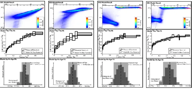
Figure 4. Results from thermal modelling of sample KR8 done using QTQt (Gallagher, 2012).
Upper panel shows the probability at each 1 Ma time step of the thermal history of the sample
passing through each pixel in temperature space. Thin line shows the best fit t-T path (Max
Posterior), which resulted in the model fit 4He/3He spectrum plotted in middle panel. Middle panel shows measured 4He/3He spectrum (black boxes) and model fit spectrum (maximum posterior, gray line). Lower panel shows measured age and uncertainty plotted over histogram
of accepted model ages. Total number of model iterations during post burn-in phase is 5 x
105.
Figure 5. Individual results from KR1, KR2, KR3, and KR4 thermal modeling with QTQt
(Gallagher, 2012). Upper panel of each shows the probability at each 1 Ma time step of the
thermal history of the sample passing through each pixel in temperature space. The thin black
line on each upper panel shows the best fit t-T path (Max Posterior) which resulted in the
model fit 4He/3He spectrum plotted in middle panel. Middle panel of each shows measured 4He/3He spectrum (black boxes) and model fit spectrum (maximum posterior, thick gray lines). Lower panel of each shows measured ages and uncertainties plotted over histogram of
accepted model ages. Total number of model iterations during post burn-in phase of each
Figure 6. Time-temperature results of composite QTQt thermal modeling of the KR1-4,
KC4 vertical transect. The model optimizes a time-variable linear thermal gradient (different
at each 1 Ma time step) across the entire vertical transect.
Figure 7. Regional map showing geographic context of study area and the location of data
from the Great Valley subsurface discussed in text. BCF = Brushy Creek Fault. KF = Kirker
Fault. KHF = Kirby Hills Fault. MF = Midland Fault. SF = Stockton Fault. PFS = Poverty
Flat Sandstone. WSFS = Western Sierra Fault System. Base image is a hillshade derived from
USGS 10 m national elevation dataset digital elevation model.
Table 1. Ap-He and Ap-4He/3He data used in this study. KR1-KR8 and 13SS6 are newly reported here. The four remaining samples are taken from previously published studies.
aSingle outlier apatite is excluded from mean. bN is number of single grain He analyses used
for each sample. cr is average equivalent spherical radius. dNR is "not reported." Where radius
not reported, sphere equivalent radius is estimated from average Ft (Farley, 1996). eeU is
effective uranium concentration, weights U and Th for their a productivity, computed as (U +
(0.235 * Th)). fUncorrected date is corrected for a-ejection using Farley et al., (1996).
gUncertainty on the mean He dates reported here as the 1 sigma standard error of the mean,
except for samples taken from (2), where standard deviation is reported. hData sources: (1) this
study; (2) House et al. 1998; (3) House et al., 1997; (4) Chen and Moore, 1982; (5) Moore and