UNIVERSITI TEKNIKAL MALAYSIA MELAKA
DEVELOPMENT
OF
GEO-LOCATION
USING
OBJECT
ORIENTED TECHNIQUE FOR SMART PARKING SYSTEM
This report submitted in accordance with requirement of the Universiti Teknikal Malaysia Melaka (UTeM) for the Bachelor Degree of Engineering Technology
(Telecommunications) (Hons.)
By
WAN HAMIDUDDIN BIN WAN MOHD RAZALI B071310421
911121065239
ii
UNIVERSITI TEKNIKAL MALAYSIA MELAKA
BORANG PENGESAHAN STATUS LAPORAN PROJEK SARJANA MUDA
TAJUK: DEVELOPMENT OF GEO-LOCATION USING OBJECT ORIENTED TECHNIQUE FOR SMART PARKING SYSTEM
SESI PENGAJIAN: 2016/17 Semester 1
Saya WAN HAMIDUDDIN BIN WAN MOHD RAZALI
mengaku membenarkan Laporan PSM ini disimpan di Perpustakaan Universiti Teknikal Malaysia Melaka (UTeM) dengan syarat-syarat kegunaan seperti berikut:
1. Laporan PSM adalah hak milik Universiti Teknikal Malaysia Melaka dan penulis. 2. Perpustakaan Universiti Teknikal Malaysia Melaka dibenarkan membuat salinan untuk
tujuan pengajian sahaja dengan izin penulis.
3. Perpustakaan dibenarkan membuat salinan laporan PSM ini sebagai bahan pertukaran antara institusi pengajian tinggi.
4. **Sila tandakan ( )
SULIT
TERHAD
TIDAK TERHAD
(Mengandungi maklumat yang berdarjah keselamatan atau kepentingan Malaysia sebagaimana yang termaktub dalam AKTA RAHSIA RASMI 1972)
(Mengandungi maklumat TERHAD yang telah ditentukan oleh organisasi/badan di mana penyelidikan dijalankan)
Alamat Tetap:
No. 97 Lorong 1,
RRM Permatang Badak,
25150 Kuantan, Pahang.
Tarikh: ________________________
Disahkan oleh:
** Jika Laporan PSM ini SULIT atau TERHAD, sila lampirkan surat daripada pihak berkuasa/organisasi berkenaan dengan menyatakan sekali sebab dan tempoh laporan PSM ini perlu dikelaskan sebagai SULIT atau TERHAD.
Cop Rasmi:
i
DECLARATION
I hereby, declared this report entitled “DEVELOPMENT OF GEO-LOCATION USING OBJECT ORIENTED TECHNIQUE FOR SMART PARKING SYSTEM” is
the results of my own research except as cited in references.
Signature : ……….
Author’s Name : ………
ii
APPROVAL
This report is submitted to the Faculty of Engineering Technology of UTeM as a partial fulfillment of the requirements for the degree of Bachelor of Electrical Engineering Technology (Telecommunications) with Honors. The member of the supervisory is as follow:
………
iii
ABSTRAK
iv
ABSTRACT
v
DEDICATION
Alhamdulillah, praise to the Almighty Allah S.W.T
This thesis is dedicated to:
My beloved family, My Parents, My Supervisor, And my Lecturers
vi
ACKNOWLEDGEMENT
I would like to express my deepest appreciation to all those who provided me the possibility to complete this report. A special gratitude I give to our final year project supervisor, Ahmad Fauzan Bin Kadmin, whose contribution in stimulating suggestions and encouragement, helped me to coordinate my project especially in writing this report.
Special thanks to my peers, my friends to had been providing me remarkable ideas to improve the project. I also want to thanks to my beloved parents because without them, I will not be able to do well in my final year project. They did give me a lot of support, both from money and moral support to help me cont
vii
TABLE OF CONTENTS
DECLARATION ... i
APPROVAL ... ii
ABSTRAK ... iii
ABSTRACT ... iv
DEDICATION ... v
ACKNOWLEDGEMENT ... vi
LIST OF TABLE ... x
LIST OF FIGURE ... xi
LIST OF ABBREVATIONS, SYMBOLS AND NOMENCLATURES ... xii
CHAPTER 1 ... 1
INTRODUCTION ... 1
1.1 Project background 1 1.2 Problem statement 3 1.3 Objective 3 1.4 Project scope 3 1.5 Project methodology 4 1.6 Thesis structure 4 CHAPTER 2 ... 6
LITERATURE REVIEW ... 6
viii
2.2 Geo-Location 8
2.3 Blynk 9
2.4 Smart Parking System Research 10 2.5 Research comparison between Journals 16 2.6 Development of Geo-location Using Object Oriented Technique for Smart
Parking System 17
CHAPTER 3 ... 19 METHODOLOGY ... 19
3.1 Flowchart 19
3.2 Hardware implementation for the project 22 3.2.1 Arduino Mega Microcontrollers 22 3.2.2 Infrared Module Obstacle Avoidance Sensor 24 3.2.3 2x16 Liquid Crystal Display (LCD) 25 3.3 Software implementation for the project 26 3.3.1 Arduino IDE Software 26 3.3.2 Proteus software 27
3.3.3 Blynk software 28
3.4 Block diagram of the project 30
3.5 Gantt chart 31
CHAPTER 4 ... 33 RESULT & DISCUSSION ... 33
4.1 Result 33
ix
4.3 Hardware Setup 36
4.4 Software Simulation of Blynk iOT 37
4.6 Discussion 39
4.7 Project analysis 41
4.7.1 IR Obstacles Sensor 41 4.7.2 Blynk Mobile Application and Prototype 45
CHAPTER 5 ... 47 CONCLUSION AND RECOMMENDATION ... 47
5.1 Conclusion 47
5.2 Recommendation 48
x
LIST OF TABLE
Table 2.1: Comparison of smart parking system 16 Table 3.1: Shows the technical spec of Mega 23 Table 4.1: Show the data taken on IR low state 42 Table 4.2: Show the data taken on IR high state 44 Table 4.3: Blynk mobile application and prototype analysis 45
xi
LIST OF FIGURE
Figure 2.1: Explained more about object oriented 7
Figure 2.2: Blynk application on iOS and Android 9
Figure 2.3: Reservation-based Smart Parking System architecture 10
Figure 2.4: Smart Parking Applications using RFID Technology 11
Figure 2.5: Car Parking System using GSM and RFID 12
Figure 2.6: QR code based Vehicle Parking System 13
Figure 2.7: The Structure of Smart Parking System Based On Reservation 14
Figure 2.8: Block diagram of Android Based Smart Parking System Using Slot Allocation & Reservations 15
Figure 3.1: Shows the Arduino Mega Microcontroller 22
Figure 3.2: IR obstacle sensor 24
Figure 3.3: Shows 2x16 LCD layouts 25
Figure 3.4: Arduino Software 26
Figure 3.5: Proteus Software 27
Figure 3.6: The architecture of Blynk 29
Figure 3.7: Block diagram of the project 30
Figure 3.8: The system architecture 31
Figure 4.1: Prototype Development of Geo-location Using Object Oriented Technique for Smart Parking System 34
Figure 4.2: Testing the project on breadboard 35
Figure 4.3: Testing the project on breadboard 35
Figure 4.4: The prototype framework 36
Figure 4.5: Arduino box 36
Figure 4.6: Connection of the prototype 37
Figure 4.7: USB serial are used to connect the Arduino 39
Figure 4.8: The servo motor 40
Figure 4.9: LED poles 40
Figure 4.10: All the parking slots are FULL 41
xii
LIST OF ABBREVATIONS, SYMBOLS AND
NOMENCLATURES
1” - 1 degree
AC - Alternative Current C - Celsius
Cm - Centimetre DC - Direct Current Ft - Feet
G - Gram
Gnd - Ground
GPS - Global Positioning System
GSM - Global System for Mobile Communication Hz - Hertz
ICSP - In-system programming
Kb - Kilo byte
Km/h - Kilometres per hour LCD - Light Crystal Display LED - Light Emitter Diode m - Meters
Mm - Millimetres mA - Mile ampere Max - Maximum Mhz - Mega hertz Min - Minimum
PC - Personal Computer PCB - Printed Circuit Board
xiii
SCL - Spam Confidence Level SDA - Data Line
S - Second
UART - Universal Asynchronous Receiver / Transmitter uS - Micro second
V - Volt
Vcc - Voltage at Common Collector Vin - Voltage in
1
CHAPTER 1
INTRODUCTION
This section focused on preparing the entire report content including the graphical illustration which can be found in appendices. This chapter focuses on the project introduction, background, problem statement, objectives and project scope regarding the project. The Development of Geo-location Using Object Oriented Technique for Smart Parking System will be explaining more in detail. The problem statement states the reason why this project is being conducted. Then, at the end of the chapter the organization of the thesis will be explain.
1.1 Project background
Time and cost are two important factors of human life, whether for an individual or a business. As quality of life increases, more and more people inhabit cities. Urban life requires centralized public facilities. Shopping complexes are an important point of interest both for a city's inhabitants as well as for visitors. With the emergence of modern shopping complexes which provide a variety of services, more and more people are attracted to visit them. Hence, more shop owners prefer to locate their business in shopping complexes to target more customers and increase revenue.
2
influenced shopping culture and behavior. For instance, in Malaysia window-shopping or visiting shopping complexes simply for looking rather than buying, is a common activity.
Providing sufficient parking for visitors is one of the main issues in developing shopping complexes. Offering safe and secure parking lots with a sufficient number of spaces and paying attention to handicapped drivers are a few of the factors which can increase customer loyalty and attract customers to visit a shopping mall more frequently. Among the various types of parking lots is multilevel parking, roadside, roadside with ticket and barrier gate and roadside with parking meter; of these, the multilevel parking lot is the most preferred by patrons. Safety, weather conditions, proximity and car park fees respectively are the main factors by which patrons choose a specific parking lot.
The main idea behind this project is to help the user analyze areas where parking is available and number of slots free in that area. The user can easily search a slot in the area he desires if it is available some hours prior to his expected arrival. This will help reduce the load on the administrator as his physical work reduces drastically. The user can search the parking slot through mobile application. Thus the application proposed in this project makes the user relief free as it reduces the time required for manually searching and waiting for empty slots to park the vehicle.
3
1.2 Problem statement
Nowadays, as the population increased in the metropolitan cities, the usage of vehicles got increased. It causes problem for parking which leads to traffic congestion, driver frustration, and air pollution. When we visit the various public places like Shopping malls, multiplex cinema hall & hotels during the festival time or weekends it creates more parking problem. In the recent research found that a driver takes nearly 8 minutes to park his vehicle because he spend more time in searching the parking lot. This searching leads to 30 to 40% of traffic congestion. The traffic congestion that occurs in and around the urban areas which is caused by vehicles searching for parking. Other than that, users are forced to take a long time to find a parking space that is empty for parking their vehicles. Lastly, users had patrolled the same area repeatedly to find a parking area which is still empty.
1.3 Objective
The project is implemented in order to achieve the following objectives which are:
a. To develop a parking system that used development of geo-location using object oriented technique for smart parking system prototype.
b. To analyze mobile application performance and requirement verification.
1.4 Project scope
There are some scope for implementing The Development of Geo-location Using Object Oriented Technique for Smart Parking System which is in hardware and software.
4
Software. After have done design circuit diagram, next is the coding part. After done the part of design circuit and coding, it will go through on simulation part by using Proteus software. After done on simulation, it needs to be tested on the breadboard first before proceed to the making prototype.
Next is software scope. In this part it will focus on the how to use the Blynk application and how to get connected between Arduino and Blynk application. This application will build up after the hardware parts are completed and functioning.
1.5 Project methodology
For this project, there are several procedures that must be followed. Initially, information about smart parking system and also the method used are identified. Then, more information about the smart parking system is gathered from the journals, internet and also articles. Next, the researches continue with the search on the basic concept of object oriented, geo-location and smart parking system. After completing the report of chapter 1, 2, 3 this project will continue to on how to design/modeling the prototype of The Development of Geo-location Using Object Oriented Technique for Smart Parking System and implement the project. Next, try the functionality of the project in hardware and software part.
1.6 Thesis structure
For the contents of this thesis, there are divided into 5 chapters.
Chapter 1:
5
Chapter 2:
Project background is discussed in this chapter. It only concentrates on the literature review that will describe all the information that was referred as a reference in order to finish up the project. Basically literature review will contain the facts or other aspects that we need that correspond to the project that will build. This chapter also defines terms used in this project and discussed the concept of the research and how it is related with the theory.
Chapter 3:
Chapter 3 describes the methodology used in this project. The schedule or steps that need to be completed and the detailed reports of studies that were done to achieve the aim of the project are presented. The methodology is the important aspect as it is the beginning process of planning. If the methodology are not organized only then will encountered the problem involve in the project.
Chapter 4:
This chapter is about the result and discussion. All the simulation, data collection and analysis obtained will be discussed in detail. The results will be compared with the objectives outlined in order to arrive to some hypothesis and conclusion.
Chapter 5:
6
CHAPTER 2
LITERATURE REVIEW
This chapter presents literature review on the development of Geo-location Using Object Oriented Technique for Smart Parking System. The main idea behind this project is to help the user analyze areas where parking is available and number of slots free in that area. In this chapter also shows the technique system that will be used in this project. Other than that, the advantages and disadvantages of this project also will be shown.
2.1 Object Oriented Technique
Object-oriented programming (OOP) is a programming paradigm based on the concept of "objects", which may contain data, in the form of fields, often known as attributes and code in the form of procedures, often known as methods. A feature of objects is that an object's procedures can access and often modify the data fields of the object with which they are associated (objects have a notion of "this" or "self"). In OOP, computer programs are designed by making them out of objects that interact with one another. There is significant diversity of OOP languages, but the most popular ones are class-based, meaning that objects are instances of classes, which typically also determine their type.
7
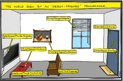
very well described as an object in terms of object-oriented programming. In the virtual world of the computer it is an object and it corresponds with other objects in the system. One of the major differences of object-oriented programming versus classical programming is the unification of data structures and functionality.
[image:22.612.121.531.305.575.2]In an object-oriented approach data and functionality would be combined. This means a graphical object might have a data-structure to store its position. Furthermore it does ‘know’ how it moves itself. Data which is stored within an object is often referred to as attributes, whereas functionality is called an operation. Figure 2.1 explained more about object oriented (Kindler, E.; Krivy, I, 2011).
8
2.2 Geo-Location
Geo-location is the identification of the real-world geographic location of an object, such as a radar source, mobile phone or Internet-connected computer terminal. Geo-location may refer to the practice of assessing the location, or to the actual assessed location. Geo-location is closely related to the use of positioning systems but may be distinguished from it by a greater emphasis on determining a meaningful location (e.g. a street address) rather than just a set of geographic coordinates.
Typically, geo-location apps do two things: They report your location to other users, and they associate real-world locations (such as restaurants and events) to your location. Geo-location apps that run on mobile devices provide a richer experience than those that run on desktop PCs because the relevant data you send and receive changes as your location changes. Smartphone today have a GPS chip inside, and the chip uses satellite data to calculate your exact position (usually when you're outside and the sky is clear), which services such as Google Maps can then map. When a GPS signal is unavailable, geo-location apps can use information from cell towers to triangulate your approximate position, a method that isn't as accurate as GPS but is has greatly improved in recent years. Some geo-location systems use GPS and cell site triangulation (and in some instances, local Wi-Fi networks) in combination to zero in on the location of a device; this arrangement is called Assisted GPS (A-GPS).
As long as the sky is fairly clear, the geo-location app on your phone can ascertain your position reasonably accurately. Indoors, however, it’s less accurate, and in locales where storefronts are in very close proximity, you may have to select your location manually from within the app interface. Eventually, though, more-advanced A-GPS systems should increase the accuracy of geo-location positioning inside buildings. These explanations are taken from Ionescu, D. (2016). Geolocation 101: How It Works,
the Apps, and Your Privacy. [Online] PCWorld. Available at:
9
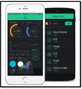
2.3 Blynk
[image:24.612.191.461.300.592.2]Blynk is a Platform with iOS and Android apps to control Arduino, Raspberry Pi and the likes over the Internet. It's a digital dashboard where you can build a graphic interface for our project by simply dragging and dropping widgets. It's really simple to set everything up and we’ll start tinkering in less than 5 mins. Blynk is not tied to some specific board or shield. Instead, it's supporting hardware of your choice. Whether Arduino or Raspberry Pi is linked to the Internet over Wi-Fi, Ethernet or this new ESP8266 chip, Blynk will get you online and ready for the Internet of Your Things. Figure 2.2 show the diagram of the Blynk application.