A consistent global approach for the morphometric
characterization of subaqueous landslides
MICHAEL CLARE
1*, JASON CHAYTOR
2, OLIVER DABSON
3,
DAVIDE GAMBOA
4, AGGELIKI GEORGIOPOULOU
5, HARRY EADY
6,
JAMES HUNT
1, CHRISTOPHER JACKSON
7, ODED KATZ
8,
SEBASTIAN KRASTEL
9, RICARDO LEÓN
10, AARON MICALLEF
11,
JASPER MOERNAUT
12, ROBERTO MORICONI
13,
LORENA MOSCARDELLI
14, CHRISTOF MUELLER
15,
ALEXANDRE NORMANDEAU
16, MARCO PATACCI
17,
MICHAEL STEVENTON
7, MORELIA URLAUB
18, DAVID VÖLKER
19,
LESLI WOOD
20& ZANE JOBE
201
National Oceanography Centre, University of Southampton Waterfront
Campus, European Way, Southampton SO14 3ZH, UK
2
United States Geological Survey, 384 Woods Hole Road, Woods Hole, MA
02543, USA
3
CH2M, Elms House, 43 Brook Green, London W6 7EF, UK
4
British Geological Survey, Cardiff University, Main Building, Park Place,
Cardiff CF10 3AT, UK
5
UCD School of Earth Sciences, University College Dublin, Dublin, Ireland
6
Fugro GeoServices Limited, Fugro House, Hithercroft Road, Wallingford,
Oxfordshire OX10 9RB, UK
7
Basins Research Group (BRG), Department of Earth Science & Engineering,
Imperial College, Prince Consort Road, London SW72BP, UK
8
Geological Survey of Israel, Jerusalem, Israel
9
Cluster of Excellence: The Future Ocean, Christian-Albrechts-Universität zu
Kiel, Leibniz Institute of Marine Sciences (IFM-GEOMAR), Kiel, Germany
10
IGME, Geological Survey of Spain, C
/
Rios Rosas 23, 28003, Madrid, Spain
11
Marine Geology and Sea
fl
oor Surveying, Department of Geosciences,
University of Malta, Msida, MSD 2080, Malta
12
Institute of Geology, University of Innsbruck, Innrain 52, Innsbruck, Austria
13
Fugro Oceansismica S.P.A., 268 Viale Lenormant Charles, Roma,
RM 00126, Italy
14
Statoil Research and Technology, 6300 Bridge Point Parkway, Austin, TX
78730, USA
15
GNS Science, Lower Hutt, New Zealand
16
Geological Survey of Canada
–
Atlantic, Bedford Institute of Oceanography,
Dartmouth, Canada
From: LINTERN, D. G., MOSHER, D. C., MOSCARDELLI, L. G., BOBROWSKY, P. T., CAMPBELL, C., CHAYTOR, J. D., CLAGUE, J. J., GEORGIOPOULOU, A., LAJEUNESSE, P., NORMANDEAU, A., PIPER, D. J. W., SCHERWATH, M., STACEY, C. & TURMEL, D. (eds) 2019. Subaqueous Mass Movements. Geological Society, London, Special Publications,477, 455–477.
First published online March 28, 2018,https://doi.org/10.1144/SP477.15
© 2018 The Author(s). This is an Open Access article distributed under the terms of the Creative Commons Attribution License (http://creativecommons.org/licenses/by/3.0/). Published by The Geological Society of London.
17
Institute of Applied Geoscience, School of Earth and Environment, University of
Leeds, Leeds LS2 9JT, UK
18
GEOMAR Helmholtz Centre for Ocean Research Kiel, 24148, Kiel, Germany
19
Marum
–
Zentrum für Marine Umweltwissenschaften, der Universität Bremen,
Postfach 330 440, 28334, Bremen, Germany
20
Department of Geology and Geological Engineering, Colorado School of
Mines, 1500 Illinois Street, Golden, CO 80401, USA
Present address: R.M., National Oceanography Centre, University of
Southampton Waterfront Campus, European Way, Southampton SO14 3ZH, UK
*Correspondence:
[email protected]
Abstract: Landslides are common in aquatic settings worldwide, from lakes and coastal environments to the deep sea. Fast-moving, large-volume landslides can potentially trigger destructive tsunamis. Landslides damage and disrupt global communication links and other critical marine infrastructure. Landslide deposits act as foci for localized, but important, deep-seafloor biological communities. Under burial, landslide deposits play an important role in a successful petroleum system. While the broad importance of understanding subaqueous landslide processes is evident, a number of important scientific questions have yet to receive the needed atten-tion. Collecting quantitative data is a critical step to addressing questions surrounding subaqueous landslides. Quantitative metrics of subaqueous landslides are routinely recorded, but which ones, and how they are defined, depends on the end-user focus. Differences in focus can inhibit communication of knowledge between communities, and complicate comparative analysis. This study outlines an approach specifically for consistent measurement of subaqueous landslide morphometrics to be used in the design of a broader, global open-source, peer-curated database. Examples from different settings illustrate how the approach can be applied, as well as the difficulties encountered when analysing different landslides and data types. Standardizing data collection for subaqueous landslides should result in more accurate geohazard predictions and resource estimation.
The importance of subaqueous landslides
for society, economy and ecology
Terrestrial landslides are important agents for the
transport of sediment and organic carbon (Korup
et al.2007;Hiltonet al.2008). They can
dramati-cally modify landscapes and ecosystems (Keefer
1984;Swansonet al.1988;Walkeret al.2009), and pose a hazard to critical infrastructure and human life (Petley 2012). High-resolution and regular satellite mapping, real-time monitoring, personal accounts, news reports, and even social media trends are used to record terrestrial landslide activity, thus pro-viding valuable and temporally-constrained informa-tion that forms the basis of extensive landslide
databases and catalogues (Malamudet al.2004;
Pet-leyet al.2005;Korupet al.2007;Kirschbaumet al.
2010;Petley 2012;Klose et al.2014;Pennington
et al. 2015; Taylor et al. 2015). These databases can be interrogated to quantify preconditioning and
triggering mechanisms, understand risk profiles for
different regions, assess the extent and nature of ancient events, calibrate numerical models of slope stability, and inform forecasts of future landslide activity. Indeed, many countries now have opera-tional real-time terrestrial landslide forecast systems
in place (e.g.Chen & Lee 2004;Baum & Godt 2010).
Landslides that occur in subaqueous settings (ranging from lakes and coastal regions to the deep sea) are also societally, economically and ecologi-cally important, yet our understanding of them is much less well developed than for their onshore
equivalents (Tallinget al.2014). Subaqueous
land-slides can be many orders of magnitude larger than
terrestrial landslides (Korupet al.2007),
transport-ing up to thousands of cubic kilometres of sediment (Mooreet al. 1989,1994;Watts & Masson 1995;
Collotet al.2001;Haflidasonet al.2004;Masson
et al. 2006; Day et al. 2015) and large volumes
of exhumed organic carbon (St-Onge &
Hillaire-Marcel 2001; Smith et al. 2015; Azpiroz-Zabala
et al.2017). Submarine and sublacustrine landslides
often generate long runout flows, which damage
strategically important seafloor infrastructure
includ-ing telecommunication cables, production platforms
and hydrocarbon pipelines (Piperet al.1999;Mosher
et al.2010b;Thomaset al.2010;Carteret al.2014;
Forsberg et al.2016;Popeet al.2017). Tsunamis generated by subaqueous landslides threaten many coastal communities and have caused large numbers
of fatalities (Tappinet al.2001;Ward 2001;Harbitz
et al. 2014). Low-lying Small Island Developing
States, such as those in the South Pacific, are
partic-ularly at risk from locally-sourced tsunamis, but little
is currently known about the scale, location and recurrence of tsunamigenic landslides in those
areas (Goff & Terry 2016). Under burial, subaqueous
landslide deposits are recognized as an important element of hydrocarbon systems: conditioning
reser-voir distribution (Armitageet al.2009;Knelleret al.
2016), acting as seals (Cardonaet al.2016) and as
potential reservoirs (Meckel 2011; Henry et al.
2017). Furthermore, heterogeneous buried
land-slides can compromise seal integrity and rearrange
subsurfacefluid plumbing systems (Gamboa et al.
2011;Riboulotet al.2013;Maiaet al.2015). The extent of submarine landslide deposits informs the placement of international economic boundaries,
as defined by the United Nations Convention on Law
of the Sea (e.g.Mosheret al.2016). The top surfaces
of mass failure deposits and areas of evacuation scarring that result from subaqueous landslides are increasingly being recognized as important habitats
for seafloor biological communities (Okey 1997;
De Mol et al. 2007; Paull et al. 2010; Chaytor
et al. 2016a; Huvenne et al. 2016; Savini et al.
2016). The direct impacts of subaqueous landslide
activity may also disturb and modify seafloor
ecology, and have been suggested as a mechanism for the dispersal of species between isolated islands,
thus governing their local evolution (
Caujapé-Castells et al. 2017). Subaqueous landslides are therefore relevant to a large number of disciplines, governments and industries, as clearly underlined in numerous papers in the predecessor volumes
to this special publication (Solheim 2006;Lykousis
et al. 2007; Mosher et al.2010a; Yamada et al.
2012;Krastelet al.2014;Lamarcheet al.2016).
Value of a global consistent database of
subaqueous landslides
Despite their importance, the study of subaqueous landslides is challenging due to their hard-to-reach nature: often in deep water and far from shore. Step-increases in knowledge have been achieved over the past few decades, however. These are largely as a result of improvements in offshore sur-veying technologies (enhanced coverage, resolution
and accuracy: Hughes Clarke 2018; Mountjoy &
Micallef 2018), coupled with increased offshore
resource exploration activities (Thomaset al.2010),
and recognition of the need to quantify the risk posed
by subaqueous landslide hazards (Vanneste et al.
2014;Mooreet al.2018). Some of the major national and international programmes that catalysed this knowledge growth include GLORIA and STRATA-FORM (offshore USA), Seabed Slope Process in Deep Water Continental Margin (northwest Gulf of Mexico), STEAM and ENAM II (European Atlantic Margins), and COSTA (Mediterranean and NE
Atlantic) (Nittrouer 1999;Locat & Lee 2002;Canals
et al.2004;Mienert 2004).
The IGCP-585, IGCP-511 and IGCP-640 pro-jects helped to build an international community of subaqueous landslide researchers with diverse tech-nical backgrounds who have documented a large number of subaqueous landslide studies from a range of physiographical, tectonic and sedimentary
settings (see papers inLykousiset al.2007;Mosher
et al.2010a;Yamadaet al.2012;Krastelet al.2014;
Lamarcheet al.2016). This community of scientists recognizes the need for the compilation of a global subaqueous landslide database, to effectively integrate the wider community knowledge and tackle
outstanding scientific questions. This is with a view
to support the following activities:
• Provide the basis for statistical analysis to robustly
test hypotheses that are currently either only qual-itatively addressed or supported by databases with relatively small sample sizes, such as exploring potential links between landslide frequency and
sea level/climate change (Geist & Parsons 2006,
2010;ten Brinket al.2006;Clareet al.2016b).
• Identify and quantify the physical controls on
landslide frequency–magnitude and triggering
between different margin types, and in different settings (e.g. high to low sedimentation regimes, lakes compared to deep-sea, etc.).
• Enable knowledge-gap analysis and to inform
future strategies for a more complete data collec-tion (e.g. identify potential blind spots, reconcile geographical, temporal and physiographical biases in the available data, and inform future selection of appropriate sampling and survey techniques).
• Quantitatively compare landslide parameters
across a range of scales (from experimental labo-ratory models, lacustrine and fjord slope failures, to prodigious continental slope collapses) to determine if any scaling relationships exist. For example, can we make informed inferences or extrapolations about the largest events on Earth from easier-to-access examples in lakes or fjords? Can we assess spatial extent through the examina-tion of a failure deposit width or thickness (e.g.
Moscardelli & Wood 2016)?
Existing subaqueous landslide databases
A number of subaqueous landslide databases already exist, but the manner in which parameters are mea-sured, and hence the consistency between studies, varies between the discipline of the data-gatherer (e.g. lacustrine or marine, ancient or recent stratigra-phy) and the end-user focus (e.g. tsunami modelling,
seafloor hazard assessment, hydrocarbon
explora-tion, benthic habitat mapping). Existing databases encompass: (i) the submarine landslide frequency (which is generally biased towards events in the
last 40 kyr;Owenet al.2007;Urlaubet al. 2013,
2014;Brotherset al.2013;Clareet al.2014;Hunt
et al.2014); (ii) geotechnical properties (Day-Stirrat
et al.2013;Sawyer & DeVore 2015); (iii) damage
to seafloor infrastructure (Popeet al.2016,2017);
and (iv) morphometrics (i.e. measurements that record the geospatial dimensions of a landslide: e.g. Moscardelli & Wood 2016). The latter is the most commonly recorded information as morpho-metrics are relevant to a wide range of applications,
including seafloor geohazard assessments (runout
distance, magnitude, spatial frequency), tsunami modelling (failure volumes and directionality), hydrocarbon exploration (extent of evacuation v. depositional zones) and benthic ecology (nature of scar and distribution of deposits). Morphometrics have been compiled for deep-sea landslides in the
Mediterranean Sea (Urgeles & Camerlenghi 2013;
Dabson et al. 2016), the North Atlantic Ocean (McAdooet al.2000;Hühnerbach & Masson 2004;
Chaytoret al.2009;Twichellet al.2009) and the
Caribbean (ten Brink et al. 2006; Harders et al.
2011). Compilations also exist for landslides in
Alpine, Chilean and Alaskan lakes (e.g.Moernaut
& De Batist 2011;Strasseret al.2013;Van Daele
et al. 2015;Kremer et al. 2017; Moernaut et al.
2017;Praetet al.2017). The few global compendia
of morphometrics that exist (e.g. lakes–Moernaut
& De Batist 2011; deep-seas–ten Brinket al. 2009,
2016; largely based on outcrop and seismic data–
Moscardelli & Wood 2016) had very different approaches in how the metrics were measured. So, while these databases are useful for intra-regional or intra-discipline comparisons, the lack of consistency in what is measured, and how, hinders direct com-parisons between different studies and thus inhibits the broader, global understanding of subaqueous landslides.
Aims
An IGCP-640-funded workshop held in January 2017 set out to discuss improved integration between the disciplines for which subaqueous landslides have relevance, and to propose a uniform method for their measurement. A proposed long-term goal is the con-struction of a global comparative landslide database that will include morphometrics, as well as other parameters. Disciplines represented at the workshop included specialists in lacustrine and deep-water
sed-imentology, seafloor habitat mapping and ecology,
marine geophysics, marine geochemistry,
hydrocar-bon exploration and production, subsurface fluid
flow and storage, offshore and coastal geohazards,
and volcanology.
In this paper we tackle three overarching
ques-tions. First, what is the benefit of a global database
of subaqueous landslides? We discuss how such a
database can provide valuable and consistent data
for scientific hypothesis testing (e.g. global to local
scaling relationships), societally-relevant applica-tions (e.g. hazard assessments), to determine
system-atic biases and identify data gaps that requirefilling.
Secondly, we ask what are the challenges and potential pitfalls in making morphometric measure-ments of subaqueous landslides using different data types, in different basins and in different ages of deposits having undergone different diagenetic changes? A global database should incorporate
obser-vations from the modern seafloor and lakes using
hull-mounted and higher-resolution (e.g. autonomous underwater vehicle (AUV)) bathymetry, 2D and 3D
seismic reflection data imaging both the seafloor
and subsurface strata, and outcrop observations. But what are the implications of comparing measurements between these different data types? We aim to under-stand what can be reliably understood and interpreted from comparisons between morphometric studies.
Finally, we ask how do you measure and describe the morphometry of both modern and ancient suba-queous landslides in a consistent manner? No com-mon method currently exists for the subaqueous landslide community. Here we present, and test, a method that can be widely adopted to enable consis-tent comparisons between workers, and thus assist in the development of a consistent ancient and modern global database. We identify a number of morphometric parameters to describe a subaqueous landslide and assess the repeatability of measure-ments made by different operators for the same
land-slide (Table 1).
How can a global database identify
and address systematic biases and
knowledge gaps?
We recognize that there are often a number of sys-tematic biases in studies of subaqueous landslides. We now discuss why these biases exist and how a global database can be used to identify and address those biases, to ensure that future studies can be
focused tofill outstanding data and knowledge gaps.
Scale bias
Many scientific studies have focused on large-scale
landslides as they are easier to image in detail than small landslides that are close to the resolution limits of the imaging tools. These larger events are also
often considered (e.g.Calveset al. 2015) to pose a
greater danger to public safety (e.g. higher tsunami-genic potential) and are therefore the focus of
atten-tion. Furthermore, smaller landslides (≪1 km3) may
be imaged in some surveys, but are often not the foci
of follow-up study as they may be less significant for
Table 1. Metrics and metadata to be included within a global subaqueous landslide database
Metric/parameter Guidance for measurement or completion
Summary
identifying
informa
tion
ID Sequential number of each landslide entry in the database
Parent ID Parent refers to the landslide complex; individual ID numbers are for each mapped landslide
Name Published name for landslide
Aliases Other names for the landslide
Frontal confinement ‘Frontally-confined’,‘frontally-confined with overrunningflow’, ‘frontally-emergent’,‘frontally unconfined’or‘not identified’ (Frey-Martínezet al.2006).
Attachment Attached or detached as defined byMoscardelli & Wood (2008) Object type Single event (mass-transport deposit) or multiple events
(mass-transport complex). Multiple events should be linked to a parent ID
Depth below seafloor (m) For landslides measured from subsurface data, this is the depth to the top of the landslide deposit. If calculated from seismic data, the two-way travel time (TWTT) should also be referenced. If mapped from seafloor data without seismic or core sample calibration this will not be possible to complete
Depth below seafloor (TWTT in ms) For landslides measured from subsurface geophysical data, this is the depth in TWTT to the top of the landslide deposit
Measur
ed
landslide
morphometrics
Latitude and longitude (WGS) Centre-point of the mapped feature. It is recognized that the entirety of a landslide may not be visible due to data coverage limitations; hence, this is primarily intended to locate the feature on a global database
Water depth minimum (m) Minimum water depth for mapped landslide (only possible from multibeam data)
Water depth maximum (m) Maximum water depth for mapped landslide (only possible from multibeam data)
Total length,Lt(m) Total mappable length of slide from the upslope limit of the headscarp to the downslope limit of the connected deposit (excludes outrunner blocks). This is measured along the axial course of the landslide if possible (e.g. from multibeam echosounder (MBES) data), otherwise this is a straight line (e.g. measured from 2D seismic data) and is an‘apparent’length measurement. Detail on the method should be listed as accompanying metadata
Deposit length,Ld(m) Total mappable length of the slide deposit (excludes outrunner blocks). This is measured along the axial course of the landslide if possible and, hence, is not necessarily a straight line (e.g. from MBES data); otherwise, this is a straight line (e.g. measured from 2D seismic data) and is an‘apparent’length measurement. Detail on the method should be listed as accompanying metadata Evacuated Length,Le(m) Length of the scar from the headscarp to the upslope limit of
deposit measured along the axial course of the landslide. Should be equal toLtminusLd
Length metadata For example, is this measured from a section and is it anapparent measurement (and thus may be an underestimate), or otherwise how was the distance calculated?
Scar perimeter length,Ls(m) Length of scar perimeter including side scarps. A spline should be fitted to the mapped scarp to ensure consistency at different data resolutions
Headscarp height,Hs(m) Height difference from the maximum convex point at the top of the headscarp to the maximum concave point at the bottom. Evacuation height,He(m) Height from the upslope limit of the landslide deposit to the
upslope limit of the headscarp
Scar width,Ws(m) Maximum scar width
Scar surface nature Descriptive explanation (e.g. concave, stepped, etc.) Maximum deposit width,Wd(m) Maximum deposit width (measured orthogonal to the deposit
length,Ld)
(Continued)
Table 1. Metrics and metadata to be included within a global subaqueous landslide database (Continued)
Metric/parameter Guidance for measurement or completion
Maximum deposit thickness, Td max(m)
Maximum measured deposit thickness in metres. Detail should be provided in the accompanying metadata as to how this was measured (e.g. from height on bathymetry or from seismic data) (and where)
Maximum deposit thickness, Td max(TWTT in ms)
Maximum measured deposit thickness in TWTT
Maximum unconfined deposit thickness,Tu max(m)
Maximum measured unconfined deposit thickness
Maximum unconfined deposit thickness,Tu max(TWTT in ms)
Maximum measured unconfined deposit thickness in TWTT
Thickness metadata How was the thickness calculated? For example, derived from multibeam data, measured from seismic (with which assumed seismic velocity?) or calibrated with core sampling data? Total height drop,Ht(m) Height from the downslope limit of the landslide deposit and the
upslope limit of headscarp
Slope gradient,S(°) Measured laterally away from the scar outside of the zone of deformation. This is intended to give an estimate of the gradient of the unfailed slope
Slope gradient metadata Notes added here to indicate the distance of the lateral offset of the measurement, distance over which the gradient was measured and any uncertainties, etc.
Slope gradient of the headscarp, Ss(°)
Maximum slope of the headscarp
Slope gradient of the headscarp metadata
Notes added here to indicate where this was measured, the distance over which the gradient was measured and any uncertainties, etc. Slope gradient at the toe,St(°) Measured in front of the toe outside of the zone of deformation. Slope gradient at the toe metadata Notes added here to indicate the distance of the lateral offset of the
measurement, the distance over which the gradient was measured and any uncertainties, etc.
Interpr
eted
landslide
metrics
Basal surface type Description of the basal surface, if mappable (e.g. rugose, planar, etc.)
Upper surface type Description of the upper surface, if mappable (e.g. rugose, smooth, etc.)
Volume (km3) Calculated deposit volume
Volume metadata How was the volume calculated? What are the assumptions? Which published method was used (if any?)
Age (years BP) If known, this is the age of the landslide in years. This may be an absolute value or a constrained age (e.g. >45 ka)
Age error Where available, the error ranges of the dates should be presented Age metadata Information on the dating method, uncertainties, where the sample
was taken (location and depth relative to the landslide deposit) and any assumptions should be referenced. Here the source of the age should also be referenced
Seafloor features metadata Useful additional information about seafloor features in the vicinity or in association with the landslide deposit, such as evidence of fluid expulsion (e.g. pockmarks)
Da
ta
sour
ce
Data type Data on which the mapping was based. High-level statement (e.g.
bathymetry, combined bathymetry and geophysics, core, deep seismic).
Data type metadata Data on which the mapping was based–more details can be provided here on combinations of sources (e.g. hull-mounted multibeam data, AUV data, 2D/3D seismic, sediment cores, etc.). This may be a combination of sources
Data source Reference to where the data came from (e.g. the data provider and the cruise, etc.). This should, ideally, include a hyperlink(s) Data repositories Where can the raw/processed data be found if they are available?
This should include a hyperlink if available
(Continued) M. CLAREET AL.
sediment transport or petroleum systems. Thus,
there is often a tendency in scientific literature
towards the landslides on the largest end of the
scale (e.g.Masson 1996); however, even small
land-slides can pose a hazard to seafloor infrastructure
(Forsberget al. 2016;Clareet al. 2017) and their
combined influence on net sediment transport may
be as significant as an individual large landslide
(Casaset al.2016). Future efforts should be made to integrate measurements of smaller landslides and several recent studies have attempted to make this
integration (e.g. Baeten et al. 2013; Casas et al.
2016;Madhusudhanet al.2017).
Preservational bias
We often make measurements based on surfaces
pre-served at seafloor or the lakebed, from seismic data
or in outcrops; however, recent repeated surveys have shown that a dramatic reworking of landslide scars and deposits can occur very soon after deposi-tion in some settings. For instance, the volume of a submarine landslide deposit in the head of Monterey Canyon, California was reduced by 80%, while the scar area increased by 40%, over the course of less
than 2 years due to current reworking (Smithet al.
2007). The evidence of landslide morphology can
be entirely wiped out in weeks to years in regions with high sedimentation rates, such as submarine
deltas (e.g. Biscara et al. 2012; Hughes Clarke
et al.2014;Clareet al.2016a;Kelneret al.2016;
Obelczet al.2017). Thus, one must acknowledge that studies of subaqueous landslide deposits record only the preserved history and may not be a full representation of all past events. The increasing use
of repeat surveys (Hughes Clarke 2018) and direct
monitoring of submarine landslides (Clare et al.
2017;Urlaubet al.2018) provide valuable resources from which to understand the limitations of
analy-sing the resultant features on the seafloor, in seismic
reflection data and from outcrop ancient deposits.
Temporal bias
There is currently a strong bias in published data-bases and collations of subaqueous landslides to
those that are less thanc.40 kyr old (i.e. the limits
of radiocarbon dating:Brotherset al.2013;Urlaub
et al.2014). Current sampling and dating methods limit the age controls we have on more ancient fail-ure deposits. This temporal bias provides challenges
when testing hypotheses such as the influence of
sea level on failure frequency or linkages between climate and failure, as the spread of landslide
occur-rence does not span sufficient sea-level stands or
climatic intervals (Pope et al. 2015). Future
data-bases should integrate modern seafloor studies with
studies of older landslides, which can be dated using other multiproxy methods (e.g. oxygen iso-topes, coccolithophore biostratigraphy,
magneto-stratigraphy and tephrochronology: Hunt et al.
2014;Clareet al.2015;Coussenset al.2016) and
imaged at depth using seismic data (e.g. Gamboa
& Alves 2016).
Geographical and economic bias
Until recent years, compilations of submarine land-slide morphometrics largely focused on the NE Atlantic, North American, Iberian and
Mediterra-nean continental margins (Popeet al.2015), where
[image:7.488.66.440.71.247.2]higher-resolution data were collected due to offshore Table 1. Metrics and metadata to be included within a global subaqueous landslide database (Continued)
Metric/parameter Guidance for measurement or completion
Publication source Where is the peer-reviewed source? If there is not one, then link to a cruise report or equivalent. If not published, then this needs to beflagged. This should include a hyperlink
Depth below seafloor metadata Notes to accompany the depth. For instance, is it the only measureable depth, an average depth or maximum depth? What was the assumed (or calibrated) seismic velocity?
Data contact Who is the contact for this dataset?
Database entry attribution Who entered the data in the database?
Database entry notes Any specifics to the data that were entered. For example, was the length recalculated from that in the original published material? Data horizontal resolution What is the horizontal resolution of the data from which the
measurements were made?
Data vertical resolution What is the vertical resolution of the data from which the measurements were made?
Additional notes Comments on any other information/considerations that should be borne in mind when using these data
In the online database entry form (https://goo.gl/o69UvY), a metadatafield accompanies each of the measured metrics to record free text commentary concerning uncertainties, errors and operator decision making.
exploration and scientific focus (e.g.Micallefet al.
2007). However, high-resolution data are now
being collected in other areas, such as South America (Völker et al.2012) and Australasia (Clarkeet al.
2012;Micallef et al.2012). A number of regions are noticeably under-represented in subaqueous landslide compilations, however; particularly those where data is scarce (e.g. East Africa) and around developing countries that are highly sensitive to
tsunami impact (e.g. South China Sea –Hu et al.
2009; He et al. 2014; Terry et al. 2017; South Pacific–Goff & Terry 2016). A truly global database will enable a more robust understanding of where data are required to better understand which regions are more and less prone to landslides (and of what
type/scale, etc.). Future research efforts should be
focused on such regions to develop appropriate risk-management procedures for developing coun-tries, and provide a more globally-balanced view of subaqueous landslides. Information from a global database could, however, be used to evaluate the potential for landslide occurrence along data-limited margins where conditions are analogous to other
better-studied margins (Adams & Schlager 2000;
Piper & Normark 2009). A consistent global data-base can provide the basis for some initial likelihood
estimates in the absence of margin-specific data, thus
extending the use of available studies to vulnerable communities.
What are the challenges and potential
pitfalls for the morphometric
characterization of subaqueous landslides?
We now outline the main issues encountered when attempting to measure the morphometry of subaqu-eous landslides.
Low data resolution relative to landslide scale
The accuracy of any morphometric landslide mea-surement is a function of the resolution of the data
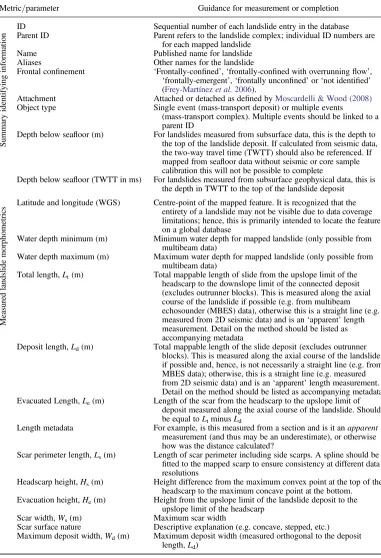
relative to the scale of the landslide (Fig. 1). In
many cases, it may be possible to make reliable
mea-surements of first-order morphometrics, such as
total landslide length or scar width, using relatively coarse resolution (often hull-mounted) multibeam
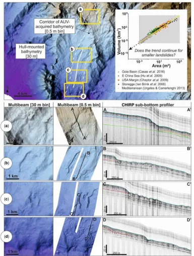
data (e.g. in Fig. 2b, a similar landslide outline
could be mapped from 30 m binned data compared to that from 0.5 m bin size). However, it is still pos-sible that many small landslides will be missed using such coarse-resolution data and more detailed measurements of evacuation or deposit length are often not feasible. It is unlikely that accurate mea-surements would be made of the landslides shown in Figure 2a or d using the 30 m bin size data alone. We must recognize, therefore, that landslide
catalogues and databases are incomplete (Malamud
et al.2004;Urgeles & Camerlenghi 2013). Measure-ment of landslides from older legacy data, that are often very low resolution, is particularly prone to this problem. The growing trend for using
auton-omous underwater vehicles (AUVs: Wynn et al.
2014) and remotely operated vehicles (ROVs:
Huv-enne et al.2016, 2018) to map the seafloor will enable us to tackle this issue and start populating the missing lower end of the scale. This is
compara-ble to that encountered when mapping other seafloor
features, such as bedforms, where new high-resolution AUV data have enabled an update of a
pre-existing classification system (Wynn & Stow
2002) tofill in some of the blanks (Symons et al.
2016).
Length measurements of irregular features, such as scar perimeter, are often highly variable between operators, depending on how complex the feature is deemed to be by each individual and to what
level of detail they define it. Limited time availability
for measurement, coupled with a large number of landslides, can lead to reduced detail in mapping and, thus, resulting in smaller perimeter lengths com-pared to a more detailed analysis. Furthermore, the measured length of a complex feature will increase if data resolution is enhanced, due to the improved imaging of a greater morphological complexity. This issue is comparable to the coastline paradox ofMandelbrot (1967), wherein the coastline of Brit-ain apparently lengthens as the resolution of
mea-surement becomesfiner.
Large landslide scales relative to the
survey area
It is difficult to accurately define landslides whose
extents are at the limits of the data resolution (
Gam-boa & Alves 2016). However, it is also clear through examining the distribution of landslide deposit sizes that there are many events that extend beyond the spatial limits of a survey or the lateral extent
of outcropping strata (Moscardelli & Wood 2016).
This latter issue is well illustrated by prodigious-scale landslides, such as the Sahara Slide (offshore
NW Africa:Georgiopoulouet al.2010), that are so
large it is usually impractical to survey their full
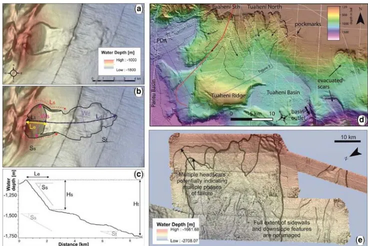
areal extent (Fig. 3e) (Liet al.2017). Similarly, the
full extent of landslides is often not imaged in seis-mic datasets where features are cropped at the limits of the survey area or whose thickness is close to the
vertical resolution limits of the data (Alves &
Cart-wright 2009;Moscardelli & Wood 2016). In such scenarios, it is possible to make measurements of the partial scar or deposits, recognizing that measure-ments are likely to be underestimated. Where such measurements are recorded in a database, the limita-tions of the available data coverage relative to the
Fig. 1. (Left) Examples of attribute analysis applied to bathymetric datasets to assist in the measurements of landslide morphometrics. Example shown is from the southern Tyrrhenian Sea based on 0.5 × 0.5 m bin size AUV bathymetry. (Right and lowermost panel) Progressive downsampling of the same AUV bathymetry to demonstrate the
implications of data resolution for imaging landslides from seafloor data.
Fig. 2. Example bathymetry from the Western Mediterranean illustrating how many small landslides observed in AUV bathymetry (0.5 m bin size) cannot be clearly imaged from hull-mounted bathymetry (c.30 m bin size). Inset graph shows published morphometric data (area versus volume), highlighting the absence of smaller landslides. Representative AUV CHIRP profiles are presented in the lower panels a–d to illustrate the nature of the sub-bottom acoustic character for several of the small landslides.
scale of the landslide should be acknowledged in accompanying metadata and must be considered in comparative analysis.
Differentiating evacuation from
depositional zones
Assuming data are resolute enough and the entire landslide is imaged, the measurement of landslide
length should be straightforward as it is defined
by the major morphological features of a landslide
(i.e. the distance from headscarp to toe: Fig. 4).
Thus, to afirst order, the scale of a landslide should
be consistently recorded between operators. Incon-sistencies may arise, however, when attempting to demarcate where an evacuation zone ends and the deposit begins, as a higher degree of interpretation is required. Some of this subjectivity can be removed where observations based on multibeam data can
be calibrated with seismic data (e.g.Figs 2and5).
Changes in acoustic character and breaks in the
continuity of seismic reflections provide valuable
information on defining limits of intact stratigraphy,
zones of removed sediment and disruption of
trans-ported sediment (e.g. Alves & Cartwright 2009;
Alveset al.2014;Strupleret al.2017). While this enables better demarcation of evacuation and deposi-tional zones, any measurement of length that is based solely on coarsely-spaced 2D seismic data (or 2D
outcrops for that matter) will be an‘apparent’
mea-surement, and is thus likely to be an underestimate. Seismic lines are rarely acquired perfectly along
the axis of runout (e.g. Fig. 2). Moscardelli &
Wood (2016)recognized this shortcoming in their morphometric analysis of landslides and took a sim-plistic approach to measure length (straight line dis-tance measured from headscarp to downslope limit of deposit). Thus, any comparison of measurements based on coarsely-spaced 2D seismic with those made from multibeam or 3D seismic data results in an estimate that may be misleading unless the line spacing is close enough. For this reason, it is preferable that measurements are integrated where complementary multibeam and seismic datasets are available.
How and where to measure slope gradient
[image:11.488.64.432.58.304.2]The measurement of slope gradient is important given the sensitivity of slope stability analysis and Fig. 3. Subaqueous landslide case studies discussed in this contribution (a) Colourscale bathymetry overlain on a greyscale slope map for relatively simple landslide (the Valdes Slide:Völkeret al.2012) offshore Chile. Example of the measured parameters for this study for the Valdes Slide are based on the plan view (b). (b) & (c) Measurements from a representative slope profile. (d) More complicated landslide example (Tuaheni Slide, New Zealand; modified fromMountjoyet al.2014). Note the cross-cutting relationship of the South and North Tuaheni slide components. (e) Example of a large submarine landslide (Sahara Slide;Liet al.2017), where only part of the scar is imaged.
volume calculations to slope gradients. This is also crucial for seismic-based studies of buried land-slides, as the velocities considered for distinct overburden intervals will affect the measured slope angles. The location and the distance over which
measurements of slope gradient are made will
greatly influence the result. Thus, it is important
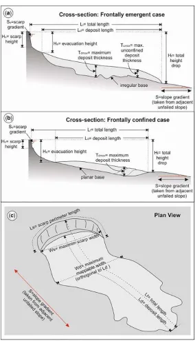
[image:12.488.97.381.53.548.2]that the location and length over which slope gradi-ent is measured are well documgradi-ented, otherwise comparisons between studies may be meaningless. Fig. 4. Schematic illustration of morphometric parameters defined inTable 1showing (a) frontally-emergent and (b) frontally-confined landslide cases in cross-section, and (c) a plan view of the landslide.
Competing subaqueous landslide classi
fi
cation
schemes
A large number of classification schemes exist for
terrestrial and subaqueous landslides (e.g. Varnes
1958; Hampton et al. 1996; Mulder & Cochonat 1996; Locat & Lee 2002; Masson et al. 2006;
Moscardelli & Wood 2008; Hungr et al. 2014). There is a high degree of subjectivity in the interpre-tation of failure mode or the nature of displacement, however. Furthermore, the complex and often trans-formative rheology of subaqueous mass movements
along their course (e.g.Tallinget al.2007;Haughton
et al.2009;Richardsonet al.2011) makes a genetic
classification challenging. On a more simple level,
however, subaqueous landslides can be differenti-ated by: (i) the nature of the landslide front (i.e. the
degree of frontal confinement); and (ii) the
relation-ship of the landslide to its source area (i.e. attached or detached).
It is important to discriminate between landslides
with different degrees of frontal confinement, as
these are associated with different formative mecha-nisms, downslope propagation, internal kinematics
and resultant deposits (Frey-Martínezet al.2006).
Frontal confinement is classified byFrey-Martínez
et al.(2006)as either: (a)‘frontally-confined’ land-slides, where the landslide front abuts undisturbed
sediments; or (b) ‘frontally-emergent’ landslides
that ramp up from their original stratigraphic
posi-tion to move across the lake or seafloor unconfined
(Moernaut & De Batist 2011). Such a simple binary
classification does not take into account natural
complexity and only applies to translational failures
which start on an intact slope profile; hence, we
sug-gest that the following terms are also used: (c)
‘frontally-confined with overrunningflow’, where a
debrisflow or incipient failure may runout over the
confined toe of a landslide; (d)‘frontally-unconfined’
landslides, where there is no downslope buttressing, such as where the toe of a slope has been excavated
by erosion or in the case of rotational failures (Lacoste
et al.2012); and (e)‘not identified’, where the data do
not enable the classification to be made.
Moscardelli & Wood (2008)proposed a binary
classification for landslide attachment that includes:
(a) landslide deposits which are attached to their
source area, which are typically regionally extensive features that occupy hundreds to thousands of square kilometres in area; and (b) landslide deposits that are detached from their scar, which are typically much smaller. Whether or not landslides are attached to their scar reveals information about the nature of the failure, if landslides were potentially tsunami-genic and has been suggested to provide an indication
of a potential triggering mechanism (Moscardelli &
Wood 2008). The use of both approaches ensures
that at least one classification can be made even
if only the source, or the front (terminal end), of a landslide is imaged and avoids the high degree of subjectivity in other more complicated genetic
clas-sification schemes.
Challenges in calculating landslide volumes
Numerous methods have been applied to the calcula-tion of landslide volume from multibeam bathymetry
[image:13.488.65.436.58.257.2]data. The first is based on an estimation of the
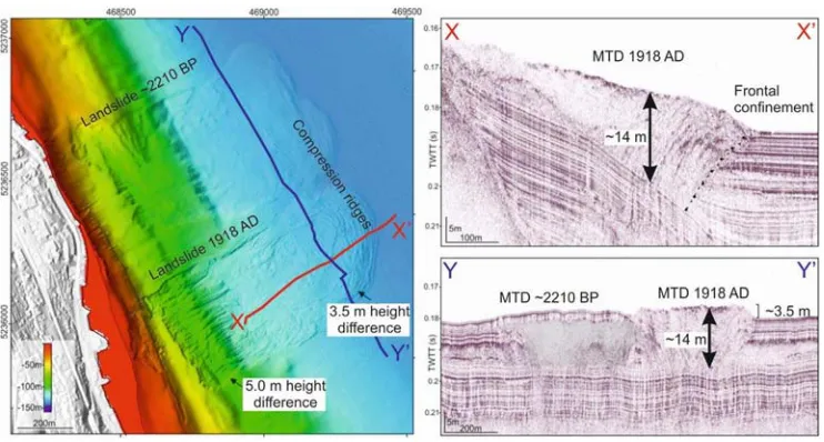
Fig. 5. Example of frontally-confined landslides in Lake Zurich (modified fromStrupleret al.2017). Volumes based on thickness measurements from multibeam data are a factor of 3 less than those calculated from seismic data.
missing volume from a scar: calculated from the dif-ference between the scar topography and an interpo-lated surface that connects the upper edges of the scar. This approach thus aims to reconstruct the
pre-failure topography (ten Brinket al.2006;Chaytor
et al.2009;Katzet al.2015;Chaytoret al.2016a,
b). The second method is based on the measured
scar dimensions (McAdooet al.2000), wherein the
landslide volume is modelled as a wedge geometry
(volume = 1/2 × area × height). The lower plane of
the wedge is derived from slope angles of the runout
and/or scar, and the upper plane is based on the
gra-dient of the unfailed slope immediately adjacent
to the seafloor (assumed to be representative of
the pre-failure slope). The third method is based on the measurements of the landslide deposit itself. This approach is often used when the scar is not
pre-served or surveyed (e.g.Massonet al.2006;Alves &
Cartwright 2009). In such a scenario, volume is determined as a function of landslide thickness and area (in the case of the lower measured value, this
was estimated as volume = area × 2/3 maximum
deposit thickness).
Ideally, additional data should supplement the calculation of landslide volume to calibrate the accuracy of measurements based on multibeam
data alone. InFigure 5, we illustrate the value of
complementary seismic data to calculate volumes
of a frontally-confined lacustrine landslide in Lake
Zurich (Strupleret al.2017). First, we calculated
vol-umes based on the multibeam bathymetry. A missing
volume of 800 000 m3 was derived from the scar
height (5 m) and its areal extent (using the method often Brinket al.2006). This value is comparable to the volume calculated from the deposit area
and its height above the adjacent seafloor (3.5 m)
mapped from bathymetry, which was calculated
as 740 000 m3. High-resolution seismic profiles
indi-cate that the thickness of the landslide (19 ms = 14 m) is actually much greater than the measured
heights from multibeam bathymetry (3.5–5 m). The
calculated volume was revised upwards by a factor
of 3 to 2 200 000 m3. This is a fundamental issue,
particularly when dealing with landslides that are
buttressed at their downslope limit (i.e. ‘frontally
confined’), as the sediment does not run over the
lakebed or seafloor: hence, its bathymetric
expres-sion is limited compared to the total thickness of sediments that are displaced. This underlines the
importance of integrating seismic data (Alves &
Cartwright 2009). 3D seismic data can provide more accurate landslide volume calculations if the deposit is fully covered by the survey and adequate
time–depth conversions are made. Thus, landslide
volume should be calculated based on the integration of multibeam and seismic data, where available. However, if only multibeam data are available, then the preferred volume estimates should be
calculated based on scar morphometrics, following
the approach often Brinket al.(2006).
Modi
fi
cation of landslide morphology
under burial
Modern multibeam bathymetry and high-frequency
sub-bottom profiling data enable high-resolution
mapping of modern landslides (i.e. those that can
be imaged at seafloor); however, additional
chal-lenges are faced when measuring older landslides imaged in lower-frequency seismic data, besides
just resolution issues. Under burial, lithification
and compaction processes can change the original morphology of landslide deposits. Mapping of landslides from seismic data is typically based on changes in the morphology, as well as the seismic character within the landslide that is a function of
both lithology and internal deformation (Ogiesoba
& Hammes 2012;Alves et al.2014). Thus, there must be a recognition that any comparison of recent landslide deposits with those that may have
under-gone significant post-depositional modification is
not necessarily like-for-like. Despite this, there is considerable value in comparing recent landslides with the range of events that have happened over a longer timescale in Earth history. Such a comparison may lead to the development of correction factors to enable more effective integration between modern and ancient studies.
Further complications caused by
natural complexity
Many subaqueous landslides are highly morpholog-ically and structurally complex. Such complexity increases the number of interpretative decisions that must be made by the operator when measuring morphometry. Many landslides do not fail as one single event; instead, occurring in stages over both
short and long timescales (e.g.Cassidyet al.2014:
Mastbergen et al. 2016). In such cases, the scar may be highly irregular, stepped or feature smaller incipient failures along the headscarp, complicating the measurement of headscarp height and scar
dimensions (e.g. Georgiopoulou et al. 2013;Katz
et al. 2015) (Fig. 3e). Areas that are highly prone to landslides may feature aggregated or cross-cutting evacuation scars and deposits from multiple different failure events. For instance, the Traenadjupet Slide overlies and cuts into the older Nyk Slide, offshore
Norway (Lindberg et al. 2004). Figure 3d shows
the case of the Tuaheni landslide complex, where multiple landslides intersect each other, and may have caused reworking of both deposits and parts
of the scar (Mountjoyet al.2014).
The large-scale Laurentian Fan landslide
pre-sented byNormandeauet al.(2018)is an example
of a complex failure that also shows localized
varia-tion in its frontal confinement; in places, the front
of the failure abuts the stratigraphy, while in others it ramps up and becomes emergent. It is thus
dif-ficult to classify into just one category. Landslide
fronts can become frontally emergent at several
locations, such as the 900 km3Traenadjupet Slide,
offshore Norway (Laberg & Vorren 2000). In that
case, multiple lobes formed at the different emer-gence points, thus providing several options for measuring total landslide length. The interaction of landslides with the underlying stratigraphy, particu-larly where erosion, ploughing or stepped frontal ramps occur, can further complicate the measure-ment of thickness and, in turn, the associated
cal-culation of volume from deposits (e.g.Richardson
et al.2011;Puzrin 2016).
How can the morphometry of subaqueous
landslides be measured consistently?
A standardized approach does not yet exist for con-sistent morphometric characterization of subaqueous landslides. Here, we present a method for measuring key subaqueous landslide morphometrics that can be
applied to seafloor, subsurface and outcrop data in
their full range of settings. The morphometric param-eters chosen are deemed to be relevant to a broad suite of disciplines. We provide instructions on
how to measure each parameter (Table 1;Fig. 4).
Given variations in data limitations and extent of
study area, it may not be possible to measure all of these parameters in all cases; however, our intention is to provide a comprehensive list to enhance the util-ity of a global database and to ensure that measure-ments are made consistent.
Testing a standardized approach
In order to test our approach for measuring landslide morphometrics, we analysed data from the Valdes
Slide, offshore Chile (Fig. 3a) (Völkeret al.2012).
A relatively simple case study was chosen for this
applications test to first understand the limitations
of the method in a close-to-ideal scenario. The Val-des Slide is considered to be a relatively simple land-slide as it does not feature multiple lobes, the scar is well imaged and it is of a scale such that most
mor-phometrics can be measured clearly. Each operator’s
analysis was performed in isolation to try to reduce interpretational bias. Software packages used for the analysis varied between operators, and included ESRI ArcGIS, Global Mapper, Teledyne CARIS, Fledermaus and Open Source QGIS. Operators based their analysis of the bathymetry on a number of different attribute tools, including contour, hill-shaded illumination, slope angle and aspect tools
(e.g. Fig. 1), as well as 3D visualization. Results
from each of the individual operators were then collated and compared to understand the variance
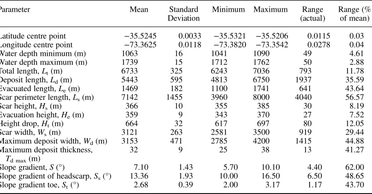
in outputs (Table 2;Fig. 6).
[image:15.488.60.441.437.637.2]Consistency in measurement offirst-order parame-ters. Parameters that locate the Valdes Slide (lati-tude, longitude and water depth) showed very good
Table 2. Results of morphometric analysis performed by the individual authors for the Valdes Slide (Fig. 3a)
Parameter Mean Standard
Deviation
Minimum Maximum Range
(actual)
Range (% of mean)
Latitude centre point −35.5245 0.0033 −35.5321 −35.5206 0.0115 0.03
Longitude centre point −73.3625 0.0118 −73.3820 −73.3542 0.0278 0.04
Water depth minimum (m) 1063 16 1041 1090 49 4.61
Water depth maximum (m) 1739 15 1712 1762 50 2.88
Total length,Lt(m) 6733 325 6243 7036 793 11.78
Deposit length,Ld(m) 5443 595 4813 6750 1937 35.59
Evacuated length,Le(m) 1469 182 1100 1741 641 43.64
Scar perimeter length,Ls(m) 7142 1455 3960 8000 4040 56.57
Scar height,Hs(m) 366 10 355 385 30 8.19
Evacuation height,He(m) 359 9 343 370 27 7.52
Height drop,Ht(m) 664 32 617 697 80 12.05
Scar width,Ws(m) 3121 263 2581 3500 919 29.44
Maximum deposit width,Wd(m) 3153 471 2785 4200 1415 44.88
Maximum deposit thickness, Td max(m)
32 9 25 38 13 41.27
Slope gradient,S(°) 7.10 1.43 5.70 10.10 4.40 62.00
Slope gradient of headscarp,Ss(°) 13.36 1.93 10.00 16.50 6.50 48.65
Slope gradient toe,St(°) 2.68 0.39 2.00 3.17 1.17 43.70
agreement (<5% range from the mean measured
values (RMMV): Table 2). Measurements of total
length measured along the landslide axis (Lt) and
the height drop (Hz: defined here as the difference
between the minimum and maximum water
depth) were comparable between operators (c.12%
RMMV). The headscarp height (Hs) and evacuated
height (He) also yielded comparable values (8–12%
RMMV:Table 2). Landslide length (runout), height
drop and headscarp height are importantfirst-order
parameters in quantifying the scale of a landslide. It is therefore reassuring that the measured values are similar between operators and provide a degree
of confidence for comparing other well-defined
land-slides using thesefirst-order metrics. Thus, a global
database should provide useful and comparable mea-surements of landslide location and scale.
Variance arising from increasing operator decision making.As anticipated, evacuated length (Le) and
depositional length (Ld) yielded more disparate
results (44 and 36% RMMV, respectively:
Table 2). This is attributed to the fact that the opera-tor needs to make an interpretative judgement based on the analysis of bathymetry data as to where evac-uation ends and deposition starts. This subjectivity could be reduced by integrating supplementary
datasets such as sub-bottom profiles; however, in
situations where further data are not available, it is important that the potential error is made clear in any metadata accompanying these measurements.
Measurements of scar width (Ws) and deposit
width (Wd) provided RMMV of 29 and 45%,
respec-tively (Table 2). An even wider spread of values
(57% RMMV) was determined for scar perimeter
length (Ls). The variance in these parameters is
attributed to the fact that these measurements are based on a higher degree of operator decision map-ping, which introduces a large degree of subjectivity
to the analysis. We suggest a spline should befitted
to the measured perimeter length to ensure consis-tency in measurement to account for different levels of data resolution. The least consistently measured
parameters were slope angles (S, Ss, St: 44–62%
RMMV). This relates to the distance over which
slopes were measured and variations in the specific
locations where those measurements were taken. Only two operators attempted to calculate vol-ume for the Valdes Slide, and provided highly
variable values of 0.3 and 1.3 km3. The highest
mea-sured value (1.3 km3) was based on an estimate of
the missing volume from the scar: calculated from the difference between the scar topography and an interpolated surface that connects the upper edges of the scar (i.e. aiming to reconstruct the pre-failure
topography, following the approach of ten Brink
et al.2006). The lower measured value (0.3 km3) was based on the landslide deposit itself.
Importance of metadata to record uncertainty
An Open Source version of the morphometric parameter inventory is hosted through a Google Fusion database. This web-based access enables the wider community to contribute morphometric data to a growing global database. In light of the challenges associated with data resolution and
operator decision making, a free text metadatafield
accompanies the entry for each of the measured met-rics to record comments on the uncertainties, errors and operator decision making involved in the data collection, analysis and measurement.
Conclusions
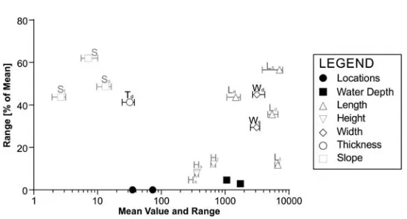
[image:16.488.96.384.49.204.2]No common method exists for describing the mor-phometry of subaqueous landslides. This hinders Fig. 6. Mean values (symbols) and total range (whiskers) from a morphometric analysis of the Valdes Slide (Fig. 3a) performed by the authors based on data inTable 2.
the effective integration of results from different research groups, disciplines and based on disparate data types. In this paper we presented and tested an approach that can be adopted to enable consistent global comparisons, and so form the basis for the compilation of a global database to integrate studies ranging from modern to ancient timescales and
lacustrine to marine settings. We identified a number
of challenges.
The first challenge is that a number of biases
exist in data collection and analysis, spanning spa-tial, preservational, temporal, geographical and eco-nomic issues. These and other biases can be better recognized and addressed by a global database of subaqueous landslides. Future data collection should aim to address these issues, such as the limited data availability in margins surrounding developing
countries. In the absence of margin-specific data, a
consistent global database of subaqueous landslides can have a powerful role, however, by enabling the inference of information (e.g. landslide likelihood) from analogous, better-studied margins.
Second, we highlighted how the accuracy and number of parameters that can be mapped is a function of landslide scale relative to the data
resolu-tion and extents. Small landslides are difficult to map
accurately (if at all) from low-resolution data, whereas large landslides may not be fully imaged by high-resolution datasets with limited extents. A global database should allow for the testing of scaling relationships on a local and global scale to provide guidance in both situations.
Finally, we presented and tested a method to enable the consistent measurement of subaqueous landslides. We found that as the degree of decision making by the operator increased, so did the uncer-tainty in the measured parameter. Basic parameters that describe the overall landslide scale (e.g. width, length) were most consistently measured. Parame-ters that required increased operator judgement (e.g. pre-failed slope, scar perimeter length) resulted in a wider range of results. We introduced a stan-dardized method of measuring morphometry, and emphasized the importance of accompanying meta-data to explain any decisions made in the measure-ment process to inform future comparative analysis. We feel this method of documenting subaqueous
landslides will provide substantial benefits to both
the research and applied community so that a con-sistent global landslide database can be developed.
Acknowledgements
The authors thank IGCP and the S4SLIDE project (IGCP-640) for funding the workshop‘A Global Database of Subaqueous Landslides’held in London on 23–24 January 2017, and for providing travel bursaries to a number of attendees. The outcomes of the workshop motivated this paper, and we hope that it will stimulate thought, discussion and action among the broader
subaqueous landslide community. This is intended to be a truly inclusive endeavour and all are invited to contribute. Any use of trade, product, orfirm names is for descriptive purposes only and does not imply endorsement by the United States Government. We thank reviewers Joshu Mountjoy, Tiago Alves and the editor, Gywn Lintern, for their critical and helpful reviews that improved the manu-script and prompted useful discussions between co-authors. The open access database contribution form is hosted at https://goo.gl/o69UvY
Funding
M.Clare acknowledges support from Natural Environment Research Council (grants NE/N012798/1 and NE/P009190/1). D. Gamboa acknowledges research support from the Sêr Cymru National Research Network for Low Carbon Energy and Economy and publishes with permission of the Executive Director, British Geological Survey. A. Georgiopolou acknowledges research support from the Geological Survey of Ireland Short Call grants. A Micallef acknowledges support from the European Research Council under the European Union’s Horizon 2020 Programme (grant agreement No. 677898 (MARCAN)). L. Moscardelli acknowledges support from the International Geoscience Programme (IGCP) (grant IGCP-640).References
ADAMS, E.W. & SCHLAGER, W. 2000. Basic types of
subma-rine slope curvature.Journal of Sedimentary Research,
70, 814–828.
ALVES, T.M. & CARTWRIGHT, J.A. 2009. Volume balance of a submarine landslide in the Espírito Santo Basin, off-shore Brazil: quantifying seafloor erosion, sediment accumulation and depletion.Earth and Planetary Sci-ence Letters,2883, 572–580.
ALVES, T.M., KURTEV, K., MOORE, G.F. & STRASSER, M.
2014. Assessing the internal character, reservoir poten-tial, and seal competence of mass-transport deposits using seismic texture: a geophysical and petrophysical approach.AAPG Bulletin,98, 793–824.
ARMITAGE, D.A., ROMANS, B.W., COVAULT, J.A. & GRAHAM, S.A. 2009. The influence of mass-transport-deposit surface topography on the evolution of turbidite archi-tecture: the Sierra Contreras, Tres Pasos Formation (Cretaceous), southern Chile.Journal of Sedimentary Research,79, 287–301.
AZPIROZ-ZABALA, M., CARTIGNY, M.J.ET AL. 2017. Newly recognized turbidity current structure can explain pro-longed flushing of submarine canyons. Science Advances,3, e1700200.
BAETEN, N.J., LABERG, J.S., FORWICK, M., VORREN, T.O., VANNESTE, M., FORSBERG, C.F. & IVANOV, M. 2013.
Morphology and origin of smaller-scale mass move-ments on the continental slope off northern Norway. Geomorphology,187, 122–134.
BAUM, R.L. & GODT, J.W. 2010. Early warning of
rainfall-induced shallow landslides and debrisflows in the USA.Landslides,7, 259–272.
BISCARA, L., HANQUIEZ, V., LEYNAUD, D., MARIEU, V., MULDER, T., GALLISSAIRES, J.M. & GARLAN, T. 2012.
Submarine slide initiation and evolution offshore Pointe
Odden, Gabon–Analysis from annual bathymetric data (2004–2009).Marine Geology,299, 43–50.
BROTHERS, D.S., LUTTRELL, K.M. & CHAYTOR, J.D. 2013. Sea-level–induced seismicity and submarine landslide occurrence.Geology,41, 979–982.
CALVES, G., HUUSE, M., CLIFT, P.D. & BRUSSET, S. 2015.
Giant fossil mass wasting off the coast of West India: the Naranja submarine slide.Earth and Planetary Sci-ence Letters,432, 265–272.
CANALS, M., LASTRAS, G., URGELES, R., CASAMOR, J.L.,
MIENERT, J., CATTANEO, A. & LOCAT, J. 2004. Slope fail-ure dynamics and impacts from seafloor and shallow sub-seafloor geophysical data: case studies from the COSTA project.Marine Geology,213, 9–72. CARDONA, S., WOOD, L.J., DAY-STIRRAT, R.J. & M
OSCAR-DELLI, L. 2016. Fabric development and pore-throat
reduction in a mass-transport deposit in the Jubilee Gas Field, Eastern Gulf of Mexico: consequences for the sealing capacity of MTDs.In: LAMARCHE, G., MOUNTJOY, J.ET AL. (eds)Submarine Mass Movements and their Consequences. Advances in Natural and Technological Hazards Research,41. Springer, Cham, Switzerland, 27–37.
CARTER, L., GAVEY, R., TALLING, P.J. & LIU, J.T. 2014.
Insights into submarine geohazards from breaks in subsea telecommunication cables.Oceanography,27, 58–67.
CASAS, D., CHIOCCI, F., CASALBORE, D., ERCILLA, G. &DE
URBINA, J.O. 2016. Magnitude-frequency distribution of submarine landslides in the Gioia Basin (southern Tyrrhenian Sea).Geo-Marine Letters,36, 405–414. CASSIDY, M., TROFIMOVS, J., WATT, S.F.L., PALMER, M.R.,
TAYLOR, R.N., GERNON, T.M. & LEFRIANT, A. 2014. Multi-stage collapse events in the South Soufrière Hills, Montserrat as recorded in marine sediment cores. In: WADGE, G., ROBERTSON, R. & VOIGHT, B.
(eds)The Eruption of Soufrière Hills Volcano, Montser-rat from 2000 to 2010. Geological Society, London, Memoirs, 39, 383–397, https://doi.org/10.1144/ M39.20
CAUJAPÉ-CASTELLS, J., GARCÍA-VERDUGO, C., MARRERO -RODRÍGUEZ, Á., FERNÁNDEZ-PALACIOS, J.M., CRAWFORD,
D.J. & MORT, M.E. 2017. Island ontogenies, synga-meons, and the origins and evolution of genetic diver-sity in the Canarian endemic flora. Perspectives in Plant Ecology, Evolution and Systematics,27, 9–22. CHAYTOR, J.D., URI, S., SOLOW, A.R. & ANDREWS, B.D.
2009. Size distribution of submarine landslides along the US Atlantic margin.Marine Geology,264, 16–27. CHAYTOR, J.D., DEMOPOULOS, A.W., URI, S., BAXTER, C.,
QUATTRINI, A.M. & BROTHERS, D.S. 2016a. Assessment of canyon wall failure process from multibeam bathy-metry and Remotely Operated Vehicle (ROV) observa-tions, US Atlantic continental margin.In: LAMARCHE,
G., MOUNTJOY, J.ET AL. (eds)Submarine Mass Move-ments and their Consequences. Advances in Natural and Technological Hazards Research, 41. Springer, Cham, Switzerland, 103–113.
CHAYTOR, J.D., GEIST, E.L., PAULL, C.K., CARESS, D.W., GWIAZDA, R., FUCUGAUCHI, J.U. & VIEYRA, M.R.
2016b. Source characterization and tsunami modeling of submarine landslides along the Yucatán Shelf/ Cam-peche Escarpment, southern Gulf of Mexico.Pure and Applied Geophysics,173, 4101–4116.
CHEN, H. & LEE, C.F. 2004. Geohazards of slope mass movement and its prevention in Hong Kong. Engineer-ing Geology,76, 3–25.
CLARE, M.A., TALLING, P.J., CHALLENOR, P., MALGESINI, G.
& HUNT, J. 2014. Distal turbidites reveal a common dis-tribution for large (>0.1 km3) submarine landslide
recurrence.Geology,42, 263–266.
CLARE, M.A., TALLING, P.J. & HUNT, J.E. 2015. Implications
of reduced turbidity current and landslide activity for the Initial Eocene Thermal Maximum – evidence from two distal, deep-water sites.Earth and Planetary Science Letters,420, 102–115.
CLARE, M.A., HUGHESCLARKE, J., TALLING, P.J., CARTIGNY, M.J.B. & PRATOMO, D.G. 2016a. Preconditioning and
triggering of offshore slope failures and turbidity cur-rents revealed by most detailed monitoring yet at a fjord-head delta.Earth and Planetary Science Letters,
450, 208–220.
CLARE, M.A., TALLING, P.J., CHALLENOR, P.G. & HUNT, J.E. 2016b. Tempo and triggering of large submarine land-slides: statistical analysis for hazard assessment. In: LAMARCHE, G., MOUNTJOY, J. ET AL. (eds) Submarine Mass Movements and their Consequences. Advances in Natural and Technological Hazards Research,41. Springer, Cham, Switzerland, 509–517.
CLARE, M.A., VARDY, M.E.ET AL. 2017. Direct monitoring of active geohazards: emerging geophysical tools for deep-water assessments. Near Surface Geophysics,
15, 427–444.
CLARKE, S., HUBBLE, T.ET AL. 2012. Submarine landslides on the upper southeast Australian passive continental margin–preliminaryfindings.In: YAMADA, Y., K AWA-MURA, K.ET AL. (eds)Submarine Mass Movements and their Consequences. Advances in Natural and Techno-logical Hazards Research,31. Springer, Dordrecht, The Netherlands, 55–66.
COLLOT, J.Y., LEWIS, K., LAMARCHE, G. & LALLEMAND, S. 2001. The giant Ruatoria debris avalanche on the north-ern Hikurangi margin, New Zealand: result of oblique seamount subduction. Journal of Geophysical Research: Solid Earth,106, 19 271–19 297. COUSSENS, M., WALL-PALMER, D.ET AL. 2016. The
relation-ship between eruptive activity,flank collapse, and sea level at volcanic islands: a long-term (>1 Ma) record offshore Montserrat, Lesser Antilles. Geochemistry, Geophysics, Geosystems,17, 2591–2611.
DABSON, O.J.N., BARLOW, J. & MOORE, R. 2016. Morpho-logical controls on submarine slab failures. In: LAMARCHE, G., MOUNTJOY, J. ET AL. (eds) Submarine Mass Movements and their Consequences. Advances in Natural and Technological Hazards Research,41. Springer, Cham, Switzerland, 519–528.
DAY, S., LLANES, P., SILVER, E., HOFFMANN, G., WARD, S. & DRISCOLL, N. 2015. Submarine landslide deposits of the
historical lateral collapse of Ritter Island, Papua New Guinea.Marine and Petroleum Geology,67, 419–438. DAY-STIRRAT, R.J., FLEMINGS, P.B., YOU, Y. &VAN DER
PLUIJM, B.A. 2013. Modification of mudstone fabric
and pore structure as a result of slope failure: Ursa Basin, Gulf of Mexico.Marine Geology,341, 58–67, https://doi.org/10.1016/j.margeo.2013.05.003 DEMOL, B., KOZACHENKO, M., WHEELER, A., ALVARES, H.,
HENRIET, J.P. & OLU-LE ROY, K. 2007. Thérèse Mound: a case study of coral bank development in the M. CLAREET AL.