UNIVERSITI TEKNIKAL MALAYSIA MELAKA
DESIGN AND ANALYSIS OF OBJECT LOCATOR IN GPS
TRILATERATION SYSTEM
This report is submitted in accordance with the requirement of the Universiti Teknikal Malaysia Melaka (UTeM) for the Bachelor of Electronics Engineering
Technology (Telecommunications) with Honours.
by
VIKNESWARAN A/L NADARAJAH B071310931
920106-14-5489
UNIVERSITI TEKNIKAL MALAYSIA MELAKA
BORANG PENGESAHAN STATUS LAPORAN PROJEK SARJANA MUDA
TAJUK: Design and Analysis of Object Locator in GPS Trilateration System
SESI PENGAJIAN: 2016/17 Semester 1
Saya VIKNESWARAN A/L NADARAJAH
mengaku membenarkan Laporan PSM ini disimpan di Perpustakaan Universiti Teknikal Malaysia Melaka (UTeM) dengan syarat-syarat kegunaan seperti berikut:
1. Laporan PSM adalah hak milik Universiti Teknikal Malaysia Melaka dan penulis. 2. Perpustakaan Universiti Teknikal Malaysia Melaka dibenarkan membuat salinan
untuk tujuan pengajian sahaja dengan izin penulis.
3. Perpustakaan dibenarkan membuat salinan laporan PSM ini sebagai bahan pertukaran antara institusi pengajian tinggi.
4. **Sila tandakan ( )
SULIT
TERHAD
TIDAK TERHAD
(Mengandungi maklumat yang berdarjah keselamatan atau kepentingan Malaysia sebagaimana yang termaktub dalam AKTA RAHSIA RASMI 1972)
(Mengandungi maklumat TERHAD yang telah ditentukan oleh organisasi/badan di mana penyelidikan dijalankan)
Alamat Tetap:
No.37, Jalan Gelora 19/46,
Seksyen 19,
40300 Shah Alam,
Selangor.
Tarikh: ______________________
Disahkan oleh:
Cop Rasmi:
Tarikh: _______________________
i
DECLARATION
I hereby, declared this report entitled “Design and Analysis of Object Locator in GPS Trilateration System” is the results of my own research except as cited in references.
Signature : ……….
Author’s Name : ……….
ii
APPROVAL
This report is submitted to the Faculty of Engineering Technology of UTeM as a partial fulfillment of the requirements for the degree of Bachelor of Electronics Engineering Technology (Telecommunications) with Honours. The member of the supervisory is as follow:
iii
ABSTRAK
iv
ABSTRACT
v
DEDICATION
vi
ACKNOWLEDGEMENT
First of all, I would like to express my full appreciation to the management of Universiti Teknikal Malaysia Melaka, for giving me an opportunity to do this bachelor’s degree project.
I also like to show my token of appreciation to our lecturers at Universiti Teknikal Malaysia Melaka who really helped me a lot throughout finishing my project. They don’t hesitate to teach me whenever I need help even when I make mistakes.
Other than that, I would like to thank my friends and coursemates who really helped in sharing their information in finishing my project.
Furthermore, I also like to thank my colleagues who helped me directly or indirectly during the journey in finishing this task.
Last but the not least, I wish to thank once again to everyone involved in completing my project and report successfully.
vii
TABLE OF CONTENT
Declaration i
Approval ii
Abstrak iii
Abstract iv
Dedication v
Acknowledgement vi
Table of Content vii
List of Tables x
List of Figures xi
List of Abbreviations, Symbols and Nomenclatures xii
CHAPTER 1: INTRODUCTION 1
1.0 Introduction 1
1.1 Project Background 1
1.2 Problem Statement 2
1.3 Objective 2
1.4 Scope 3
1.5 Structure of Report 3
CHAPTER 2: LITERATURE REVIEW 5
2.0 Introduction 5
2.1 Global Positioning System (GPS) 5
2.1.1 Overview of GPS 6
2.1.2 GPS Segments 7
2.1.3 Basic GPS Concept 8
2.1.4 Why Use GPS? 10
2.2 Trilateration System 11
2.2.1 Basic Equations for Finding User Position 12
2.2.1.1Calculation of Altitude 13
viii 2.2.1.3 Calculation of a Point on the Surface of the Earth 17 2.2.1.4Calculation of Object Position Using ECEF Method 18
CHAPTER 3: METHODOLOGY 20
3.0 Introduction 20
3.1 Flowchart 20
3.1.1 Literature Review 21
3.1.2 Animation 21
3.1.3 Design 22
3.1.4 Calculation 23
3.1.5 Analyse 25
3.1.6 Report Writing 25
3.2 Adobe Flash Professional CS5.5 26
3.2.1 Timelines 26
3.2.2 Animation 27
3.3 Graphical User Interface 28
3.4 Project Implementation (Gantt Chart) 30
CHAPTER 4: RESULT & DISCUSSION 31
4.0 Introduction 31
4.1 Animation 31
4.2 Calculation 35
4.3 Simulation 38
4.4 Analysis 41
4.5 Discussion 42
CHAPTER 5: CONCLUSION & FUTURE WORK 43
5.0 Introduction 43
5.1 Conclusion 43
5.2 Recommendations 44
ix
APPENDICES 47
A Gantt Chart (Project Planning) 47
x
LIST OF TABLES
4.1 Tabulated calculation results Satellite 1 35
4.2 Tabulated calculation results Satellite 2 36
4.3 Tabulated calculation results Satellite 3 37
xi
LIST OF FIGURES
2.1 GPS constellation 6
2.2 GPS segments 7
2.3 One-dimensional user position 8
2.4 Two-dimensional user position 9
2.5 Use three known positions to find one unknown position 12
2.6 A basic ellipse with accessory lines 13
2.7 Altitude and latitude illustration 14
3.1 Flowchart of the project 20
3.2 Editor window layout 28
3.3 Callback template for an editable text box 29
3.4 Callback template for a push button 29
3.5 Gantt chart of the project 30
4.1 Editor window of Adobe Flash software 31
4.2 Start-up cover of animation 32
4.3 Coverage of Satellite 1 32
4.4 Coverage of Satellite 2 33
4.5 Coverage of Satellite 3 33
4.6 Exact object location 34
4.7 Start-up display of GUI 38
4.8 GUI display for ECEF method 39
4.9 GUI display for latitude, longitude and distance method 39
xii
LIST OF ABBREVIATIONS, SYMBOLS AND
NOMENCLATURE
1
CHAPTER 1
INTRODUCTION
1.0 Introduction
This chapter gives a brief on the project background, problem statement, objectives, scope and limitation of the project. Understanding on the overall description of project can be gain through this chapter.
1.1 Project Background
2
1.2 Problem Statement
Considering FTK itself, many students and even lecturers do not know how GPS works. The lack of knowledge of locator by using GPS has been a major problem since it may be a mostly used item in the coming future. Moreover, the technology of GPS locator is still not widely used. Many navigation applications such as Google Map and Waze require internet to operate. We, as students face many issues regarding personal financial problems. Due to that factor, most of the students doesn’t subscribe to internet data plans. Many telcos providing data plans with higher rate which students cannot afford to buy one. This is why the GPS technology is still not widely used among students. Other than that, the GPS accuracy is still low. Sometimes, when we used to navigate to a certain location, the GPS tends to lead to a different location which may located near to the desired location. This proves that the GPS sometimes may provide wrong positioning. To have a fully operational GPS system, a GPS interface need to be utilized.
1.3 Objective
The objectives of this project are:
1. To understand the working principle of trilateration system as well as the GPS system.
2. To design object locator system using Graphical User Interface (GUI) in MATLAB software which determines the location of an object.
3
1.4 Scope
This project research will focus primarily on the functions of a GPS as well as the trilateration system. This system will be created using the MATLAB software which can be useful in producing the appropriate GUI. Other aspects such as the production of project (hardware) and marketing of this features will not be covered in this project.
There are several scopes considered in this project research that can be categorized into four main element processes. These elements can help to obtain the understanding about the whole project research in order to develop the project. The elements are:
a) Animation. b) Calculation. c) Simulation.
Lastly, the task will be continued on writing the project report.
1.5 Structure of Report
This thesis contains of five chapters. Chapter one describes about introduction, problem statement of the project, objective of the project that describes the reason for developing this project, scope of the project and the structure of report.
Chapter two covers the literature review about the Design and Analysis of Object Locator in GPS Trilateration System. This chapter reviews on previous research, references and journals about related topics to this project. Various methods and approaches that are related to the project are discussed and reviewed.
4 Chapter four explains the results, analysis and discussion of this project. This project used all the research that currently being done to get all the results. The analysis from the information is very important to produce the data that is needed and related to the topic of this project. The flow chart of the project and the diagram are used to explain in this chapter.
5
CHAPTER 2
LITERATURE REVIEW
2.0 Introduction
Literature review will be continuously carried to study past and current research works. Many applications and related studies are done by the navigation authorities and also researchers related to the topic. Some very important data have to be studied, reviewed, determined and will be applied for the project.
2.1 Global Positioning System (GPS)
The Global Positioning System (GPS) is a satellite-based course structure that was made by the U.S. Division of Defense (DoD) in the mid-1970s as the forefront substitution to the Transit structure. At to begin with, GPS was delivered as a military system to fulfill U.S. military needs. In any case, it was later made open to customary subjects, and is right now a twofold use structure that can be gotten to by both military and non-military staff customers.
GPS gives predictable arranging and timing information wherever on the planet under any atmosphere conditions. Since GPS is a confined broadening (standoffish) system, it serves countless and furthermore being used for security reasons. That is, customers can simply get the satellite signs (Ahmed El-Rabbany, 2006).
6 be perceived by anyone with a GPS authority. There are various applications for the stand-out navigational structure. This system can be used for plane and vehicle course, rocket bearing, and geographical mapping. Our essential fixation is to execute the Global Positioning System Network reasonably that licenses investigating, arranging, and following in an indoor space (Michael Wright, Dion Stallings and Dr. Derrek Dunn, 2003).
2.1.1 Overview of GPS
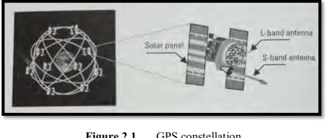
[image:20.595.153.484.492.632.2]GPS comprises, ostensibly, of a heavenly body of 24 operational satellites. This star grouping was finished in July 1993, which was known as the underlying operation capacity (IOC). The authority IOC declaration, notwithstanding, was made on December 8, 1993. To guarantee persistent overall scope, GPS satellites are masterminded with the goal that four satellites are put in every six orbital planes as shown in Figure 2.1. With this heavenly body geometry, four to ten GPS satellites will be obvious anyplace on the planet, if a height veil of 10 degrees is considered. As talked about later, just four satellites are expected to give the situating, or area, data.
Figure 2.1 GPS constellation
7 The comparing GPS orbital period is roughly 12 sidereal hours (~11 hours, 58 minutes). The GPS framework was authoritatively announced to have accomplish full operational capability (FOC) on July 17, 1995, guaranteeing the accessibility of no less than 24 operational, nonexperimental, GPS satellites. Truth be told, since GPS accomplished its FOC, the quantity of satellites in the GPS group of stars has dependably been more than 24 operational satellites.
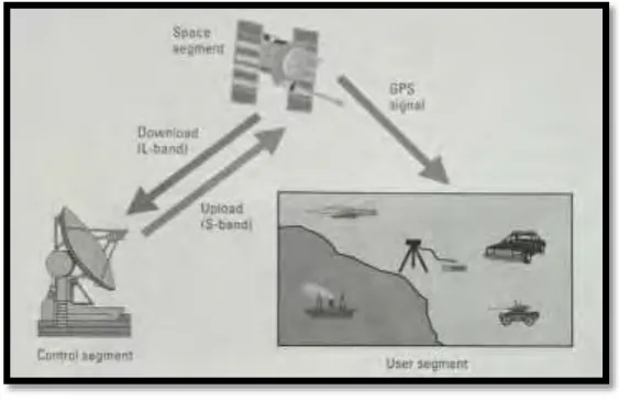
2.1.2 GPS Segments
[image:21.595.177.459.553.741.2]GPS comprises of three sections: space, control, and client as shown in Figure 2.2. The space portion comprises of the 24-satellite group of stars presented in the past area. Every GPS satellite transmits a signal, which has various parts: two sine waves (otherwise called bearer frequencies), two advanced codes (or more for modernized GPS satellites), and a route message. The codes and the route message are added to the transporters as paired biphase tweaks. The transporters and the codes are utilized mostly to decide the separation from the client's collector to the GPS satellites. The route message contains, alongside other data, the directions (the area) of the satellites as a component of time. The transmitted signs are controlled by exceedingly precise nuclear timekeepers on load up the satellites.
8 The control fragment of the GPS framework comprises of an overall system of following stations, with a master control station (MCS) situated in the United States at Schriever Air Force Base close Colorado Springs, Colorado. The essential assignment of the operational control section (OCS) is to track the GPS satellites utilizing various checking stations, so as to decide and anticipate satellite areas, framework respectability, conduct of the satellite nuclear timekeepers, climatic information, the satellite chronological registry, and different contemplations. This data is then stuffed and transferred to the GPS satellites by the ground reception apparatuses through the S-band connect.
The client fragment incorporates all military and regular citizen clients. With a GPS collector associated with a GPS radio wire, a client can get the GPS signals, which can be utilized to decide his or her position anyplace on the planet. GPS is as of now accessible to all clients worldwide at no immediate charge.
2.1.3 Basic GPS Concept
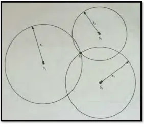
[image:22.595.158.478.659.718.2]The position of a specific point in space can be found from separation measured starting here to some known positions in space. Let us use some examples to decide this location. In Figure 2.3, the client position is on the x-axis; this is a one-dimensional case. On the off chance that the satellite position S1 and the separation to the satellite x1 are both known, the client position can be at two spots, either to the left or right of S1. Keeping in mind the end goal to decide the client position, the separation to another to another satellite with known position must be measured. In this figure, the places of S2 and x2 extraordinarily decide the client position U.
9 Figure 2.4 demonstrates a two-dimensional case. With a specific end goal to decide the client position, three satellites and three separations are required. The hint of an indicator with consistent separation a settled point is a hover in the two-dimensional case. Two satellites and two separations give tow conceivable arrangements since two circles meet at two focuses. A third circle is expected to exceptionally decide the client position.
Figure 2.4 Two-dimensional user position
For comparable reasons one may choose that in three-dimensional case four satellites and four separations are required. The equivalent separation follow to a settled point is a circle in a three-dimensional case. Two circles converge to make a circle. This circle converges another circle to create two focuses. With a specific end goal to figure out which point is the client position, one more satellite is required.
In GPS the position of the satellite is known from the ephemeris information transmitted by the satellite. One can quantify the separation from the beneficiary to the satellite. Accordingly, the position of the collector can be resolved.
10 mistake. Be that as it may, the separation measured between the recipient and the satellite has a consistent obscure predisposition, in light of the fact that the client clock more often than not is unique in relation to the GPS clock. So as to determine this predisposition mistake one more satellite is required. Accordingly, keeping in mind the end goal to discover the client position five satellites are required.
In the event that one uses four satellites and the deliberate separation with inclination blunder to gauge a client position, two conceivable arrangements can be acquired. Hypothetically, one can't decide the client position. Be that as it may, one of the arrangements is shut to the world's surface and the other one is in space. Since the client position is generally near the surface of the earth, it can be particularly decided. Consequently, the general explanation is that four satellites can be utilized to decide a client position, despite the fact that the separation measured has a predisposition blunder.
The underlying position is regularly chosen at the focal point of the earth. The emphasis strategy will unite on the right arrangement as opposed to the one in space. In the accompanying talk four satellites are viewed as the base number required in finding the client position (James Bao and Yen Tsui, 2005).
2.1.4 Why Use GPS?
GPS has altered many fields (e.g., studying and route) since its initial phases of advancement. Despite the fact that GPS was initially composed as a military framework, its common applications have developed much speedier. With respect to the future, it is said that the quantity of GPS applications will be restricted just by one's creative ability.