© Commonwealth of Australia, March 2015
Published by the Great Barrier Reef Marine Park Authority ISBN 978 1 922126 57 3
This publication is licensed under a Creative Commons Attribution 3.0 Australia License with the exception of content supplied by third parties, logos, the Commonwealth Coat of Arms and any material protected by a trademark.
Creative Commons Attribution 3.0 Australia Licence is a standard form licence agreement that allows you to copy, distribute, transmit and adapt this publication provided you attribute the work. A summary of the licence terms is available from creativecommons.org/licenses/by/3.0/au/deed.en. The full licence terms are available from
creativecommons.org/licenses/by/3.0/au/legalcode.
This publication should be cited as:
McCook, L.J.; Schaffelke, B.; Apte, S.C.; Brinkman, R.; Brodie, J.; Erftemeijer, P.; Eyre, B.; Hoogerwerf, F.; Irvine, I.; Jones, R.; King, B.; Marsh, H.; Masini, R.; Morton, R.; Pitcher, R.; Rasheed, M.; Sheaves, M.; Symonds, A.; Warne, M.St.J.2015, Synthesis of current knowledge of the biophysical impacts of dredging and disposal on the Great Barrier Reef: Report of an Independent Panel of Experts, Great Barrier Reef Marine Park Authority, Townsville.
National Library of Australia Cataloguing-in-Publication entry
Synthesis of current knowledge of the biophysical impacts of dredging and disposal on the Great Barrier Reef: Report of an Independent Panel of Experts / L. McCook, B. Schaffelke, S. Apte, R. Brinkman, J. Brodie, P. Erftemeijer, B. Eyre, F. Hoogerwerf, I. Irvine, R. Jones, B. King, H. Marsh, R. Masini, R. Morton, R. Pitcher, M. Rasheed, M. Sheaves, A. Symonds, M.St.J. Warne.
Includes bibliographical references.
Dredging—Environmental aspects—Queensland—Great Barrier Reef. Dredging spoil—Queensland—Great Barrier Reef.
Fishes—Effect of dredging on—Queensland—Great Barrier Reef. Aquatic plants—Effect of dredging on—Queensland—Great Barrier Reef. Environmental monitoring—Queensland—Great Barrier Reef.
Great Barrier Reef (Qld.)—Environmental conditions.
627.7309943
Requests and enquiries should be addressed to:
Great Barrier Reef Marine Park Authority Australian Institute of Marine Science 2-68 Flinders Street PMB 3, Townsville MC
PO Box 1379 TOWNSVILLE QLD 4810 TOWNSVILLE QLD 4810 AUSTRALIA
AUSTRALIA
Synthesis Report on Effects of Dredging on the Great Barrier Reef by Independent Expert Panel p. ii
Acknowledgements
The Great Barrier Reef Marine Park Authority and the Australian Institute of Marine Science would like to thank:
The Expert Panel participants
Mr Tim Moltmann (Australia’s Integrated Marine Observing System) CSIRO’s Land and Water Division
CSIRO’s Marine and Atmospheric Research Division James Cook University
Jacobs Group (Australia) Pty Ltd
The UWA Oceans Institute, University of Western Australia Southern Cross University
Pollution Research Pty Ltd RPS APASA Pty Ltd
Office of the Environmental Protection Authority, Western Australia RMC Pty Ltd
Royal Haskoning DHV
Queensland Department of Science, Information Technology, Innovation and the Arts. The Great Barrier Reef Marine Park Authority and the Australian Institute of Marine Science also acknowledge the invaluable contributions of Traditional Owners and stakeholders consulted during the development of the project.
Preface
The issue of port development in the Great Barrier Reef Region has been a significant issue for government, industry and the wider community over the past few years. This review was commissioned by the Australian Institute of Marine Science and the Great Barrier Reef Marine Park Authority to assess the available information relating to the effects of dredging activities in the Region.
The work of the Expert Panel was largely completed in late 2014. Since those deliberations there have been changes in the publicly available forecasts of dredge material volumes and disposal locations.
In November 2014 the Federal Minister for the Environment committed to a ban on the disposal of capital dredge material in the Great Barrier Reef Marine Park, which forms 99 per cent of the Great Barrier Reef World Heritage Area. In February 2015, the new Queensland Government committed to legislate to restrict capital dredging for the development of new or expansion of existing port facilities to within the regulated port limits of Gladstone, Hay Point/Mackay, Abbot Point and Townsville, and to prohibit the sea-based disposal of dredge material from these sites in the Great Barrier Reef World Heritage Area.
These changes have been incorporated into this report as clearly identifiable updates, as of March 2015. All changes made to the Report due to this March 2015 update are indicated by blue shading of the text. These changes also take into account updated estimates of river loads of sediments.
Notwithstanding these changes in development and management, dredging and the disposal of dredge material continues to be an important pressure in the Great Barrier Reef.
The Australian Institute of Marine Science and the Great Barrier Reef Marine Park Authority are very grateful to the members of the Expert Panel for producing this synthesis of current
knowledge about the impacts of dredging. Our wish is that this synthesis report will spark further inquiry that will increase understanding of our coastal systems and the way our
Synthesis Report on Effects of Dredging on the Great Barrier Reef by Independent Expert Panel p. iv
Contents
Executive summary ... 1
Introduction ... 5
Expert Panel process and report ... 9
1. Changes to the physical and chemical environment from dredging and dredge material disposal: Pressures... 11
Overview ... 11
1.1 Physical and chemical changes to the environment due to dredging operations . 16 1.2 Physical and chemical changes to the environment due to disposal of dredge material in the marine environment ... 18
1.3 Effects of dredging and dredge material disposal on immediate and long-term sediment dynamics, including transport and resuspension ... 19
1.4 Comparison of sediment inputs to the Great Barrier Reef from dredging and terrestrial run-off ... 29
1.5 Nutrients, organic matter and potential contaminants in sediment that is being dredged and disposed ... 35
2. Effects on biodiversity of pressures from dredging and disposal ... 41
2.1 Effects on coral reefs ... 45
2.2 Effects on seagrass meadows ... 50
2.3 Effects on other seafloor habitats ... 55
2.4 Pelagic habitats ... 57
2.5 Estuarine and mangrove habitats ... 58
2.6 Effects on fish... 59
2.7 Effects on marine megafauna and other species of conservation concern ... 61
3. Disposal of dredge material in reclamation and on land ... 65
3.1 Disposal of dredge material in reclamation ... 68
3.2 Disposal of dredged material on land ... 69
4. Cumulative pressures and declining condition on the Great Barrier Reef and the contribution and context of dredging and disposal ... 71
5. Next steps... 74
References ... 79
Appendix A: Synthesis panel and workshop process ... 98
Appendix B: Details and data sources used for the comparison of sediment and nutrient inputs into the Great Barrier Reef World Heritage Area from dredge material disposal and terrestrial run-off ... 128
Appendix C: Maps of ports ... 144
Appendix D: Compilation of evidence for effects of dredging on Great Barrier Reef coral reefs ... 157
Appendix E: Compilation of evidence for effects of dredging on Great Barrier Reef seagrass meadows ... 169
Appendix F: Compilation of evidence for effects of dredging on Great Barrier Reef seafloor infaunal habitats ... 174
List of Figures
Figure 1: Actual historical and projected future volumes of dredge material disposed in marine environments of the Great Barrier Reef World Heritage Area
Figure 2: Existing ports in and adjacent to the Great Barrier Reef World Heritage Area Figure 3: Components of vulnerability assessments
Figure 4: Handling uncertainty within the Expert Panel process
Figure 5: Relationships between the activities of dredging and dredge material disposal, the major (potential) pressures and their effects on key habitats and other biodiversity values of the Great Barrier Reef World Heritage Area
Figure 6: Conceptual illustration of important sediment dynamics processes in the Great Barrier Reef
Figure 7: Distribution of sediment sizes in Great Barrier Reef seafloor Figure 8: Comparison of estimated total and fine sediments from rivers
(black/grey/white) and dredging (red)
Figure 9: Contrasting condition and recovery of seagrasses in the Ports of Cairns and Townsville
Figure 10: Contrasting examples of seafloor habitats
List of Tables
Table 1: Dredging activities and related pressures
Table 2: Qualitative risk assessment of the exposure of Great Barrier Reef ecosystems and values to major pressures from dredging
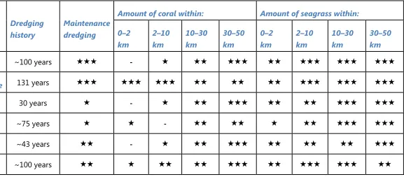
Table 3: Comparison of nutrient content in dredged sediment with inputs from rivers Table 4: Proximity of coral reefs and seagrass meadows to dredging and disposal
activities associated with major ports
Synthesis Report on Effects of Dredging on the Great Barrier Reef by Independent Expert Panel p. 1
Executive summary
This report provides an independent synthesis of the current knowledge of the effects of dredging and sediment disposal on the physico-chemical environment and the biological values of the Great Barrier Reef World Heritage Area (World Heritage Area), as assessed by an Expert Panel.
Dredging and sediment disposal can change the physical and chemical environment and affect the biological values of the World Heritage Area. Many of these effects will be context dependent and will differ between locations, types and extent of dredging and sediment disposal activities. The Expert Panel’s evaluation identified the following key direct and indirect effects:
Removal by excavation during dredging operations. Most current and proposed dredging activities are carried out within soft-sediment seafloor habitats, sometimes supporting seagrass, and do not involve excavation of coral reefs. The area directly affected by excavation is generally only a small proportion of relevant habitats. Although this effect is severe within that footprint, and could be significant regionally, the overall ecological significance of direct removal to the Great Barrier Reef was considered to be small. There is evidence of very low levels of mortality of marine turtles during dredging excavations, which is reduced by the use of turtle deflection devices.
Burial at marine dredge material disposal and reclamation sites. Current and proposed disposal of dredge material does not take place on coral reefs, but may affect a range of soft-sediment seafloor habitats, sometimes including seagrass. The area directly affected by burial is generally a small proportion of relevant habitats, so although the effects are severe within that limited footprint, and could be significant regionally, the overall ecological significance to the Great Barrier Reef was considered to be small. Changes to bathymetry and hydrodynamics by excavations. These changes were
considered to be localised in the Great Barrier Reef and sufficiently predictable by modelling.
Increased artificial lighting (at night) and underwater noise may have significant impacts on marine wildlife. It is difficult to distinguish to what extent, if any, effects are due to dredging per se, as distinct from the effects of other port, urban and industrial
infrastructure and activities.
Potential contributions to chronic suspended sediments: Importantly, both disposed sediments and dispersed sediments from dredge plumes have the potential to be resuspended and transported by waves and ocean currents, and to contribute to the long-term, chronic increase in fine suspended sediment concentrations in the inshore Great Barrier Reef. The extent to which this occurs and affects biodiversity was not agreed by the Expert Panel. In particular, panellists had differing views on whether any additional contribution from dredging was significant compared to background levels of resuspension and inputs of fine sediments in run-off from catchments.
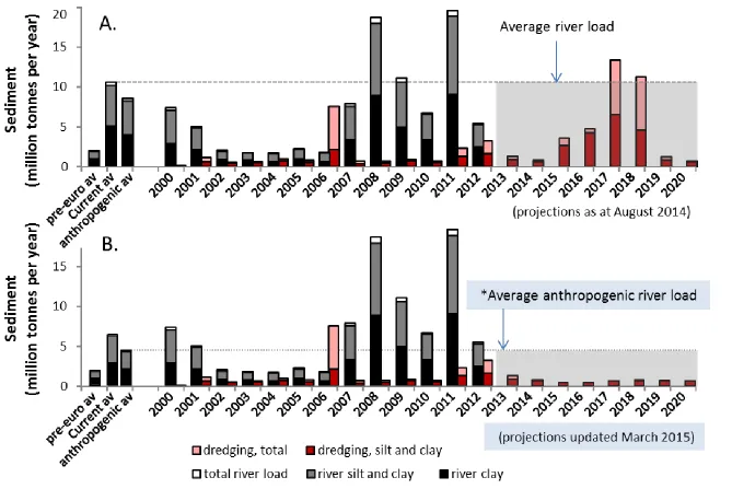
It is difficult to compare sediment released from dredging with inputs from terrestrial run-off, as there are limited data and many differences in the physical and chemical properties, the delivery to and the transport and fate in the waters of the Great Barrier Reef and the methods for measuring these processes. In particular, significant but unknown proportions of fine sediments in dredged material will not be available for resuspension. Acknowledging these difficulties, the Expert Panel compared overall amounts, and the amounts of fine sediments, from recent and proposed dredging activities in the Great Barrier Reef with the amounts estimated from rivers under natural and current conditions. Although some members of the panel had differing views on the validity and methods of these comparisons, the results show that dredging is a
potentially significant source of sediments, and fine sediments in particular, being at least similar in magnitude to estimated natural inputs from rivers and potentially similar to anthropogenic inputs from catchment land uses.
March 2015 update: The Panel re-analysed this comparison, based on updated
projections for future disposal of dredged sediments in the Great Barrier Reef, provided by the Great Barrier Reef Marine Park Authority, along with updated estimates of average river loads. The updated projections for dredge disposal reflect the recent policy
commitments to ban disposal of capital dredge material in marine environments (see Preface). The Panel recognized that implementation of these policies will mean that dredging will contribute much less fine sediment in the future (potentially about 5-10 percent of the estimated long-term average input from rivers in the comparison). It must be emphasised that this comparison is only intended to provide broad context for dredging and that dredge amounts released to the ecosystem will only be a proportion of these amounts; the comparisons should not be interpreted beyond that context.
Synthesis Report on Effects of Dredging on the Great Barrier Reef by Independent Expert Panel p. 3 as the majority of dredging and disposal in the Region takes place at some distance from coral reefs. Available monitoring does not suggest that recent dredging projects in the Great Barrier Reef have directly resulted in significant, short-term coral mortality but sublethal effects are uncertain, as are effects of long-term contributions to suspended sediments. In particular, suspended sediments may have serious impacts on recovery of reefs from other disturbances (reducing resilience); such impacts would not be detected in most environmental impact assessments and are potentially important given the degraded condition of many inshore reefs in the regions where dredging takes place. Seagrass meadows near dredging activities in the Great Barrier Reef have a high
exposure and sensitivity to dredging pressures, although some also have high capacity for recovery. Monitoring provides no evidence for long-term impacts of maintenance dredging on seagrass, although it cannot preclude short-term impacts. Direct and indirect impacts on seagrasses of past capital dredging have been documented, albeit generally inside predicted areas. Losses were a relatively small proportion of local
seagrass populations, but even small losses are more critical in the context of the overall degraded condition of Great Barrier Reef seagrass populations.
Disposal of dredge material on land or in reclamation. The Expert Panel identified a number of potential impacts and challenges involved in disposing of dredge material on land or in reclamation. These include:
Loss of coastal habitats, many already under considerable pressure, due to the large areas required to process dredged sediments.
Run-off of seawater from the dredge material, which may contain large amounts of fine sediments, into freshwater or coastal ecosystems.
Potential acid sulphate soils, with associated risks of production of sulphuric acid and the release of quantities of potentially toxic metals such as iron and aluminium.
Although the Expert Panel prioritised synthesis of existing knowledge, its evaluation
identified significant areas of insufficient knowledge. Of particular importance is the need for improved understanding of long-term sediment dynamics in the World Heritage Area. There is also a need for more extensive, long-term and better integrated monitoring and
assessment of dredging and disposal effects in the World Heritage Area, and a need for that information to be more readily accessible to the public and the research community. Further, there is a need to quantify the sensitivity of a wider range of marine species, including but not limited to a wider range of coral and seagrass species, to the effects of increased
turbidity, suspended sediments and sedimentation. Other information needs are outlined in the body of this report.
similar syntheses of available knowledge on the social, economic, cultural and heritage aspects of dredging and sediment disposal, including Indigenous culture and heritage ongoing review and enhancement of policies, governance, planning and assessment
procedures for dredging activities in the World Heritage Area, to ensure better outcomes for both the environment and users, including ports
better acquisition, integration and accessibility of knowledge and information targeted research to address the key knowledge gaps identified in this statement, to
Synthesis Report on Effects of Dredging on the Great Barrier Reef by Independent Expert Panel p. 5
Introduction
The Great Barrier Reef is a national treasure, andWorld Heritage Area, but the recently released Great Barrier Reef Region strategic assessment report1 and Outlook Report 20142 show that the Great Barrier Reef is in decline, especially in the inshore areas of the southern two-thirds of the region. In this context, it is critical that we understand and reduce the cumulative impacts of all pressures on this iconic ecosystem.
This report has been prepared by an Expert Panel of independent scientists to synthesise information and knowledge of the actual and potential pressures posed by dredging and dredge material disposal on the physical, chemical and biological environment of the World Heritage Area (detail below and in Appendix A).
Dredging is the excavation or removal of sediment and/or rock from the seabed and is a routine part of port operations and of coastal and marine infrastructure developments (for detailed technical information see3). The recent resources boom in Australia has led to demand for more and larger ports, especially along thesubtropical and tropical coast, with many current and planned port developments involving the dredging of millions of cubic metres of sediment, especially in Western Australia3. In the Great Barrier Reef, major dredging operations are currently underway or planned for the expansion of existing ports (Figure 1). While some of these expansions may not occur, the proposed volumes are significant by global standards4.
There are two major types of dredging operations: capital dredging is carried out to open up new shipping channels, marina or port basins or berth pockets, or to deepen or widen existing areas. Maintenance dredging keeps previously dredged areas at the required depth. Large capital dredging campaigns (volumes of 500,000 m3 and larger) occur infrequently, are generally of longer duration (weeks to months or years), and generally remove seabed material with a wide range of particle sizes (gravel, sands, silts and clays). Maintenance dredging campaigns are undertaken at regular intervals (years) or as required, are typically of short duration (days to weeks), and generally remove sediments with a higher proportion of finer particles.
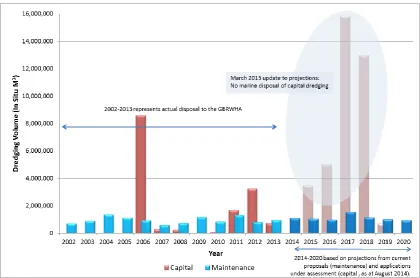
Figure 1: Actual historical and projected future volumes of dredge material disposed in marine environments of the Great Barrier Reef World Heritage Area.
Source: Great Barrier Reef Marine Park Authority (GBRMPA) and Department of the Environment (see Appendix B, Table B-6).
Future projections assume all referred projects being approved and proceeding as proposed (August 2014). Update March 2015: Advice from GBRMPA indicates that volumes projected for future disposal (2014 -2020) of capital dredging will be zero (see explanation below).
Disclaimer: Actual disposal volumes (2000-2013, capital and maintenance) were collated based on annual reporting requirements to the Great Barrier Reef Marine Park Authority and the Department of the Environment (as part of annual reporting requirements to the International Maritime Organisation under the Sea Dumping Act) and on historical disposal information provided by port operators. Maintenance dredge disposal volumes forecasted for future years were based on historical averages of actual disposal volumes supplied to the Great Barrier Reef Marine Park Authority and the Department of the Environment. Where increase in future maintenance dredging is anticipated as a result of capital expansion, forecasts are based on publicly available information contained in proposals referred under the EPBC Act as of 25 August 2014. Capital dredge volumes forecasted for future years were based on publicly available information contained in proposals referred under the EPBC Act as of 25 August 2014. They reflect the proposed volume to be disposed.
Update March 2015: Since the original analyses in August 2014, there have been a number of significant changes in the policy context around projected volumes of capital dredged material. These changes include:
withdrawal of proposed capital dredging at Hay Point
anticipated delay in proposed capital dredging at Gladstone
Synthesis Report on Effects of Dredging on the Great Barrier Reef by Independent Expert Panel p. 7
Marine Park boundary- see Appendix C)
Commitment by newly elected Queensland State Government to restrict major capital dredging to the ports of Townsville, Abbot Point, Hay Point / Mackay and Gladstone and to prohibit the disposal of dredge material from these sites in the Great Barrier Reef World Heritage Area. This would suggest that there will be no marine disposal of capital dredge material in the forecast period to 2020 (the World Heritage Area does include existing spoil grounds).
On this basis, and to ensure the ongoing relevance of the entire Report, the Expert Panel agreed to update relevant sections of this Report (Fig. 1, Executive Summary and Sections 1.4 and 1.5), on the basis of updated projections for disposal of dredge material in the marine environment, provided by GBRMPA on 6 March 2015. For transparency, all such updates are indicated by blue shading behind new text; no material or content has been removed for this update. The Expert Panel also notes that i. the benefits of these new policy commitments will depend on their effective implementation; and ii. the disposal of capital dredged material on land instead of in the marine environment brings an attendant set of environmental and other challenges (Section 3).
Dredging has occurred in the Great Barrier Reef since ports were established. For example, dredging began off Townsville in 1883 and off Cairns in 1888. Historical data for Port of Townsville dredging operations report regular (monthly to annual) maintenance dredging and occasional capital dredging operations in Cleveland Bay from 1889 to 19885.
Dredging and the disposal of dredge material within and adjacent to the Great Barrier Reef Marine Park and the World Heritage Area have recently become contentious issues for the government, stakeholder groups and the general public. It is widely recognised that
dredging activities need to be carefully managed as they may impact areas of conservation value through degradation of water quality, changes to the hydrodynamic regime,
smothering of benthic biota, translocation of species and removal of habitat. Management measures to reduce these impacts include planning, environmental impact assessment, avoidance, minimisation and compensation measures6.
The recently released Queensland Ports Strategy7 prescribes four ports in the World Heritage Area (Abbot Point, Gladstone, Hay Point and Mackay, and Townsville) as Priority Port
Development Areas (PPDAs) and states that “the Queensland Government will prohibit dredging for the development of new, or the expansion of existing port facilities outside PPDAs, for the next ten years.” Figure 2 shows the current main ports in the World Heritage Area and detailed maps of each port area are provided in Appendix C.
In the World Heritage Area dredging and the disposal of dredge material in the marine environment is only permitted after comprehensive environmental assessment and approval under Queensland and Commonwealth legislation (which, as of March 2015, are undergoing significant changes, as noted above). Under the Commonwealth, this includes the
Environment Protection and Biodiversity Conservation Act 1999 and the Environment
There are also engineering approaches that can be used to reduce release of fine sediments during dredging and disposal and to reduce the need for or provide alternatives to
[image:14.595.136.457.156.563.2]dredging10.
Synthesis Report on Effects of Dredging on the Great Barrier Reef by Independent Expert Panel p. 9
Expert Panel process and report
The dredge synthesis project is a joint initiative between the Great Barrier Reef Marine Park Authority (GBRMPA) and the Australian Institute of Marine Science (AIMS). The process involved convening an Expert Panel to develop and publish this synthesis statement. Key experts were invited to participate, with the aim of bringing together a broad range and diversity of skills, experience and perspectives (further detail on the process is provided in Appendix A; see Acknowledgements for contributing organisations).
This report synthesises information and knowledge of the actual and potential pressures posed by dredging and sediment disposal on the physical, chemical and biological environment of the Great Barrier Reef. It focuses on coral reefs, seagrass meadows, inter-reefal, soft-bottom and pelagic habitats, fish, marine megafauna and other threatened species. Where the information was sparse, the report also draws on information from outside the Great Barrier Reefs.
The purpose of this project and report is to provide an independent, objective and evidence-based overview of the biophysical effects of dredging pressures, thereby providing a
stronger foundation for further development of policy, guidelines and assessment
procedures for development proposals that involve dredging. The report seeks to provide improved understanding of the risks associated with dredging; that is, what is known and not known about past and potential future biophysical impacts of dredging in the marine
environment of the Great Barrier Reef Region. This understanding includes identification of points of agreement and disagreement among technical experts.
The scope of this synthesis is limited to biophysical effects, and does not address social, economic, cultural or heritage aspects at this stage (but see final Next Steps section). Aside from the (March 2015) updated analyses of projected dredge amounts noted above (Fig. 1), the Report reflects available information as of August 2014.
The approach and terminologyb used in this synthesis report are consistent with those of the Great Barrier Reef Outlook Report 20142 and the Great Barrier Reef Region Strategic
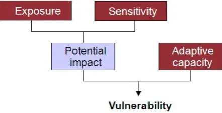
Assessment 11, drawing on the frameworks of the Vulnerability Assessment12 approach (Figure 3) and the DPSIR framework13 of Drivers (dredging and disposal activities), Pressures (Section 1 of this report), State and Impact (Section 2 of this report) and management Response (out of scope for this project). Although a comprehensive vulnerability assessment is beyond the scope of this report, it does aim to provide the foundations for such assessment. Specifically,
b A range of different terms are used to refer to disposal (e.g. dumping, disposal, placement) of dredged material
(sometimes referred to as spoil) in scientific, legislative and public domains. For this report, Panel members had a range of views, but overall felt that the most appropriate terms in this context are “disposal” and dredge
Section 1 of the report outlines general aspects of exposure to dredging related pressures, and Section 2 considers the exposure for specific habitats and biodiversity values, along with their sensitivity and adaptive capacity.
Handling uncertainty and incomplete information
The workshop and resulting report aimed to synthesise the state of knowledge, but not necessarily to achieve complete consensus amongst panellists across all topics. Rather, the intent was to explicitly identify areas of:
1. Broad, scientific agreement (and the evidence-base for this);
2. Scientific uncertainty, debate or disagreement (and related evidence, and the nature of further evidence required to resolve the issue);
3. Knowledge gaps (and the research that would adequately address those gaps).
[image:16.595.73.294.148.261.2]This approach (Figure 4) allowed the Expert Panel to focus on identifying what is known and agreed, and provide focus for resolving or progressing areas of disagreement or debate, rather than stalling on those areas.
Figure 3: Components of vulnerability assessments12.
Synthesis Report on Effects of Dredging on the Great Barrier Reef by Independent Expert Panel p. 11
1.
Changes to the physical and chemical environment from dredging and
dredge material disposal: Pressures
Overview
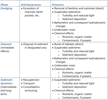
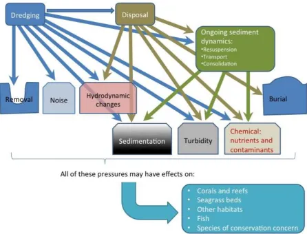
Dredging can directly affect the marine environment, within the physical footprint of the excavation work, by removing sediment, hard substratum and associated plants and animals (Table 1; conceptual model in Figure 5). In addition, there are multiple indirect effects, especially effects associated with the release of fine sediments into the water column during the excavation. This generally increases water turbidity (reducing availability of light
[image:17.595.75.519.324.735.2]underwater) and sediment deposition, and potentially releases nutrients, carbon and contaminants (if present), over areas larger than the direct excavation footprint. Finer sediments are of particular concern because they are most readily resuspended and transported and may carry more chemicals, due to their high surface area to volume ratio.
Table 1: Dredging activities and related pressures
Phase Activity/process Pressures
Dredging Excavation of
channels, berth pockets, etc.
Removal of benthos and substrate (direct) Suspended sediments:
o Turbidity and reduced light o Sediment deposition
Bathymetric and consequent hydrodynamic changes
Underwater noise Chemical effects:
o Nutrients, organic matter o Contaminants, if present
Disposal (immediate effects)
Disposal of sediment in designated area
Burial of habitats (direct) Suspended sediments:
o Turbidity and reduced light o Sediment deposition
Bathymetric and consequent hydrodynamic changes
Underwater noise Chemical effects:
o Nutrients, organic matter o Contaminants, if present
Sediment dynamics (intermediate and long-term)
Resuspension Transport Consolidation,
armouring
Suspended sediments:
o Turbidity and reduced light o Sediment deposition Chemical effects:
The disposal of dredged sediment has the direct effect of burial (covering) of habitats and organisms at permitted dredge material disposal areas, and indirect effects including
[image:18.595.75.522.214.554.2]immediate release of fine sediments, and over longer time frames the potential dispersion of deposited fine sediment. Release and dispersion of fine sediments may involve release of nutrients, carbon and contaminants (if present). In this report, we distinguish between complete burial (by very large amounts of sediment during dredge disposal), and sedimentation and smothering effects (due to general deposition and settlement of suspended sediments).
Figure 5: Relationships between the activities of dredging and dredge material disposal, the major (potential) pressures and their effects on key habitats and other biodiversity values of the Great Barrier Reef World Heritage Area.
The immediate and ongoing contributions to sediment dynamics are issues of fundamental importance and significant uncertainty.
Synthesis Report on Effects of Dredging on the Great Barrier Reef by Independent Expert Panel p. 13 sediment, such as particle size, nutrient and contaminant content; the type of dredging equipment used; the prevailing physical (e.g. currents, tides, waves) and water quality conditions in the area and the proximity and type of biological communities.
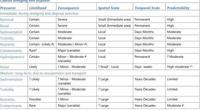
Table 2:Qualitative risk assessment of the exposure of Great Barrier Reef ecosystems and values to major pressures from dredging.
Explanation of approach and terms below tables; explanation of assessments in following subsections. Assessments refer to dredging in the Great Barrier Reef overall, but would depend greatly on the size of the dredging operation, and would vary amongst locations and with other conditions such as weather and currents.”?” indicates high degree of uncertainty in score.
Capital dredging and disposal
Pressures
Likelihood
Consequence
Spatial Scale
Temporal Scale
Predictability
Immediate: during dredging and disposal activities
Removal
Certain Severe Small (Immediate area) Permanent HighBurial
Certain Severe Small (Immediate area) Permanent HighSedimentation
Certain Moderate Local Days-Months ModerateTurbidity
Certain Moderate Local Days-Months ModerateNutrients
Certain- (Likely #) Moderate (-Minor #) Local Days-Months ModerateContaminants
Rare* Major (variable) Local Days-Months HighHydrodynamics
Certain Minor – Moderate # (variable)Local Permanent ? Moderate
Noise
Likely ? Minor - Moderate ? Small - Local Days -weeks High-moderate **Synthesis Report on Effects of Dredging on the Great Barrier Reef by Independent Expert Panel p. 15
Maintenance dredging and disposal
Pressures
Likelihood
Consequence
Spatial Scale
Temporal Scale
Predictability
Immediate: during dredging and disposal activities
Removal
Certain Minor Small (Immediate area) ? Months-Years HighBurial
Certain Moderate # Small (Immediate area) ? Months-Decades High - moderateSedimentation
Certain Moderate- Minor # Local Days-Months ModerateTurbidity
Certain Moderate- Minor # Local Days-Months ModerateNutrients
Certain Moderate- Minor # Local Days-Months ModerateContaminants
Rare* Major (variable) Local Days-Months HighHydrodynamics
Certain Minor- Insignificant Local Permanent HighNoise
Likely ? Minor ? Small Days -weeks High - moderate**Medium -long-term: due to resuspension and transport
Sedimentation
? Likely ? Minor - Moderate(variable)
? Large Years-Decades Limited
Turbidity
? Likely ? Minor - Moderate (variable)? Large Years-Decades Limited
Nutrients
Possible ? Minor ? Large Years-Decades Limited – moderate#
Explanation for Table 2: In order to manage pressures on the values of the Great Barrier Reef, management agencies need to understand key attributes of those pressures—the what, where, when and how much. These attributes include the elements of risk assessments (likelihood and consequences), which in turn require explicit consideration of the spatial and temporal scales of the pressures: a small but long-term risk requires a different response to a large but short-term risk. Also important for management is our ability to predict those properties; that is, how accurately we can predict the what, where, when and how much, and hence implement management that matches the risks. Likelihood and Consequences categories are adapted from the Great Barrier Reef Outlook Report2, except that in Table 2 assessments refer to impacts within affected areas, with temporal and spatial scales identified separately:
Likelihood: Refers to how probable a pressure is to occur: Certain; Likely; Possible; Unlikely; Rare. Consequences: Refers to the impact of the pressure, where and when it does occur: Severe; Major;
Moderate; Minor; Insignificant.
Spatial Scale: Refers to the approximate spatial extent over which a pressure occurs: Small: Immediate, defined area of activity (e.g. dredging excavation or disposal ground) < ~20 km2; Local: Bay-wide: ~20–200 km2; Large: 200–2000 km2; Regional: >2000 km2.
Temporal Scale: Refers to the approximate duration in time over which a pressure occurs: Hours to days; days to weeks; weeks to months; months to years; years to decades; permanent. Predictibility: Refers to the precision and accuracy with which managers can predict the likelihood,
consequences and scale of each pressure, whether using computer models or other techniques; assumes availability of relevant sampling and data: High; Moderate; Limited. Assuming effective implementation of current management guidelines9.
** Adequate data not currently available, but should be readily acquired using available technology and methods. # Assessments differed among the Expert Panel.
Physical and chemical changes to the environment due to dredging operations 1.1
The process of excavating the seabed during dredging operations can lead to direct and indirect, immediate and long-term changes to the physico-chemical environment.
The most immediate, direct effect is that of removal of habitat through the excavation: within the limited footprint of the area dredged, there will be complete and effectively permanent removal of the substratum, including any benthic biota living there. The extent of this effect can be predicted with considerable precision and as early as the design phase of any dredging project.
Synthesis Report on Effects of Dredging on the Great Barrier Reef by Independent Expert Panel p. 17 quality and quantity causing turbidity, increases sedimentation, and potentially releases contaminants and nutrients occurring from natural or anthropogenic sources at the site. The severity, spatial extent and duration will be highly dependent on the characteristics of the dredged sediment, the site and time-specific physical conditions such as winds, waves, currents and tides (hereafter referred to as ‘metocean conditions’c) and the type, scale and duration of dredging operation. The fine sediments transported away from the dredging site eventually settle and are potentially available for secondary resuspension by wind, currents and tides. Sedimentation and turbidity increases can be predicted using modelling (but see discussion of limitations below, Section 1.3), given sufficient calibration and validation sampling before the dredging. The extent and significance of sediment dynamics are discussed in detail in Section 1.3.
Sediment disturbance through dredging will release particulate and dissolved nutrients from sediment pore waters, and readily soluble nutrients desorbing from suspended sediment. While these nutrients are already present in the system, they are mobilised by the sediment disturbance which can potentially increase the nutrient availability at a local scale. Although the National Assessment Guidelines for Dredging (NAGD)9 do not require analysis of nutrients in sediments before dredging, analyses are frequently undertaken15. Available information on nutrient release is assessed in detail in Section 1.5.
Chemical contaminants are sometimes present in dredged sediments as a result of existing port, industrial, urban and agricultural activities, but are generally considered a relatively low risk in the Great Barrier Reef16. Any such contamination is generally confined to inner
harbour areas and berthing pockets, and in most areas of the World Heritage Area, including shipping channels outside the ports, chemical contamination is considered relatively low16. The NAGD9 prescribe a stringent process of testing and management of chemical
contaminants in sediments as part of assessments for the marine disposal of dredge material. Further discussion of chemical contaminants in dredged or disposed sediment is below in Section 1.5.
Increased underwater noise during dredging operations, due to the machinery involved, is certain and predictable in severity and duration, and generally comparable with noise from other shipping activities (see e.g.17). How underwater noise affects marine animals, especially marine megafauna, is discussed below in Section 2.7. Dredging activity at night will
contribute to the overall increased (above-water) light levels, with potential consequences for marine wildlife (Section 2.7).
c ‘metocean conditions’ is a combination of the terms meteorological and oceanographic, used to describe the
Physical and chemical changes to the environment due to disposal of dredge 1.2
material in the marine environment
Depositing dredge material in the coastal or marine environment will lead to direct, indirect, immediate and long-term physical and chemical changes to the environment.
The burial and smothering of habitats and sessile organisms at the disposal site is certain, effectively permanent and will be complete, as most organisms will be buried too deep to survive. Recolonisation and recovery of habitats and organisms may occur over time following cessation of disposal activities, although the recolonised assemblage may differ from the natural assemblage due to differences such as depth or sediment composition. These localised impacts are an unavoidable consequence of dredge material disposal but are typically limited to the actual, designated disposal site. As at January 2012, the combined area of dredge spoil disposal grounds in the Great Barrier Reef World Heritage Area where localised effects are concentrated was 66 square kilometres1 (which amounts to less than 0.02 per cent of the World Heritage Area).
Planning and site selection (see Appendix C for detailed maps of currently used dredge material disposal sites) allows for minimisation of the direct impacts, such as by avoiding high-value habitats. The extent to which burial results in environmental impacts is generally site-specific and depends on the characteristics and volume of the dredged sediment, the frequency of disposal, the water depth and hydrodynamic conditions, and the type of benthic community present. Available literature indicates that impacts vary from few or no detectable effects to large, long-term impacts18,19,20,21. Given suitable planning, appropriate characterisation of the material to be dredged and appropriate hydrodynamic modelling and measurements, the spatial extent of burial should be highly predictable.
Synthesis Report on Effects of Dredging on the Great Barrier Reef by Independent Expert Panel p. 19 The placement of dredged material at a disposal site will cause changes in hydrodynamics by locally raising the seabed, although this is likely to be minor at the depths (10–20 m) of existing marine disposal areas in the World Heritage Area. The effect of disposal of large volumes in a small area would be predictable with appropriate hydrodynamic and sediment transport modelling and unacceptable impacts could be managed through the approval process. Disposal of dredged sediment into coastal bunded areas for reclamation will alter hydrodynamics by altering the coastline; although again this should be readily predictable (see also Section 3).
Increased underwater noise from shipping movement during disposal of dredged sediment is considered to be minor (see e.g.17,23).
Effects of dredging and dredge material disposal on immediate and long-term 1.3
sediment dynamics, including transport and resuspension
Background
The immediate and longer term fate of sediments, especially fine sediments, mobilised during dredging and disposal is a critical issue that must be evaluated in the context of local and Great Barrier Reef-scale knowledge of hydrodynamics and sediment dynamics. Fine sediments can seriously affect key World Heritage Area ecosystems such as coral reefs and seagrass beds (Section 2; recent reviews20,24,25,26).
Sediment dynamics in the inshore Great Barrier Reef are largely dominated by the wave and current-driven resuspension and transport of accumulated seabed sediment deposits27,28,29,30. Important additional inputs of fine suspended sediments are delivered in catchment run-off, especially during flood events24,31,32,33,34,35. The delivery of fine sediments from the catchment to the Great Barrier Reef has increased many-fold, correlated with agricultural development after European settlement around 185032, as indicated by analyses of coral core records of suspended sediment delivery 24,36,37,38,39. In the short-term, most of the suspended sediment transported in flood plumes is deposited on the seabed within 10 km of the coast40.
However, a portion of the fine sediment fraction can form organic flocs and be transported far from its source (up to 100 km41). Most of these remain in the Great Barrier Reef lagoon for several months after a flood event, and sustain elevated turbidity through repeated resuspension42,43,44,45.
However, the many-fold increases in inputs of fine sediments over the last century or more would counter that flushing, and may have contributed significant proportions of the current ambient fine sediments available for resuspension. The demonstration that riverine inputs can have persistent effects on turbidity over months to years44,45 supports this interpretation, suggesting resupply of fine sediments does contribute to overall turbidity. Not all members of the Expert Panel supported this interpretation. The following sections summarise current understanding of these processes and the significant knowledge gaps therein.
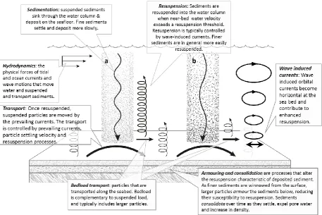
[image:26.595.73.531.259.564.2]The effects of increased inputs of fine sediment on marine ecosystems depend on the balance between, or relative rates of, sediment settlement/deposition, and resuspension, transport and flushing29 (see Figure 6).
Figure 6: Conceptual illustration of important sediment dynamics processes in the Great Barrier Reef. Sediment column (a) shows fine “cohesive” sediment (particle size <63 µm), which can aggregate, (b) shows “non-cohesive” sediment of generally larger particle size.
Synthesis Report on Effects of Dredging on the Great Barrier Reef by Independent Expert Panel p. 21 Different sizes of sediment particles are subject to different physical processes. For example, ‘cohesive’ particles are primarily clays (<2–4 μm diameter, depending on classification system47) and silt (<63–75 μm), often mixed with organic matter, while ‘non-cohesive’ particles are primarily sand and larger-sized materials (>63 μm) 48. Transport and deposition of cohesive particles is primarily controlled by advection, dispersion, aggregation, settling, consolidation, and erosion, while transport of non-cohesive particles is controlled by
advection, dispersion, settling, armouring, and transport in suspension and along the seabed as ‘bedload’ 49. These generic sediment transport processes require site-specific information on; for example, grainsize distribution of the dredged material, settling rates, resuspension thresholds and potential consolidation rates. In addition, reliable field measurements of hydrodynamic parameters and a detailed bathymetry are needed before any meaningful predictions can be modelled, as part of the development of an effective dredging and spoil disposal management plan.
Sediment transport is mostly northward along the coast, driven by residual currents and the prevailing south-east trade winds, with much of the fine sediments eventually trapped in north-facing bays50. Tropical cyclones have the potential to carry coastal sediments further offshore43 and also influence the formation of distinct cross-shelf zones with fine sediments mostly restricted to the inner and inner-middle shelf of 0 to 20 m depth, at least in the central Great Barrier Reef51,52. Overall, longer term fine sediment transport processes in the Great Barrier Reef are not well quantified.
Surveys of large areas of the seabed of the Great Barrier Reef lagoon53 show a wide range of sediment types in the coastal and interreefal areas (see Figure 7). Within this broader picture, there is considerable spatial variation at local scales in the dispersive or retentive
characteristics of the seabed in relation to fine sediment, depending on coastline features (bays compared to promontories), bathymetry and hydrodynamics. At present there is insufficient understanding of the temporal and spatial variability of sediment retention and dispersion processes within the various ecosystems of the World Heritage Area, and the influence of extreme conditions such as major storms or tropical cyclones on these
processes. Addressing that knowledge gap will be facilitated by the eReefs project, which is currently developing and applying Great Barrier Reef-scale models of hydrodynamics, sediment transport and biogeochemistryd.
Figure 7: Distribution of sediment sizes in Great Barrier Reef seafloor
Map is split into northern (left) and southern (right) areas. Courtesy of CSIRO/AIMS/QDPI/QM Seabed Biodiversity Project53.
A key knowledge gap, hindering understanding of sediment dynamics generally and dredging impacts specifically, is a means to accurately measure net sediment deposition rates within sensitive ecosystems over appropriate time frames. While research to develop methods and sensors is currently underwaye, there is currently no technique that can be deployed over the large spatial scales required for dredge monitoring programs. The
Synthesis Report on Effects of Dredging on the Great Barrier Reef by Independent Expert Panel p. 23 more pronounced at flow speeds >10–20 cms-1, which is typical of coral reef
environments27,65,66 and suggests that sediment trap data should be interpreted with care56.
Fate of dredged material
To evaluate potential impacts of dredging on the World Heritage Area, it is critical to understand the long-term fate and transport of fine material (i) disturbed from the dredge site, including dredge overflow; (ii) released during disposal; and (iii) resuspended from the dredge material disposal area. Technically, maintenance dredging does not generally add new sediments to the system; rather, it releases/remobilises sediments that are subsequently available for further resuspension and transport. During capital dredging campaigns, deeper excavation releases sediment previously not available to resuspension, and rock or other hard substrate may be broken up into smaller material to enable excavation and extraction. Some members of the Expert Panel considered that dredging has contributed to the long-term siltation70 of the inshore Great Barrier Reef, at least locally and potentially at larger scales through ongoing resuspension and transport. However, others disagreed, considering that contribution highly unlikely. Irrespective, the extent of the contribution of sediment mobilised by dredging to the overall fine sediment budget of the Great Barrier Reef has not been assessed; Section 1.4 attempts a simple quantitative comparison using existing
information (and a range of assumptions).
The degree to which such resuspension and dispersal of dredged sediments contributes to or increases ambient or background resuspension of fine sediment from the seabed will depend on a complex interplay of many factors: (i) the composition of the dredge material, particularly the proportion of fine sediments. Dispersal of clay particles may be reduced by aggregation into clumps which settle quickly. Conversely, organic-rich fine sediments can aggregate/flocculate, stay in suspension longer and be dispersed farther; (ii) metocean conditions at the dredging and disposal sites, including ‘typical’ and extreme conditions such as calm, strong south-easterlies, and cyclone conditions, which may resuspend and disperse the disposed sediment (but also the surrounding seafloor sediments over large areas); (iii) consolidation or compaction of the sediment; (iv) ‘armouring’ by coarser particles, due to the winnowing out of fine materials from the surface layers and (v) biological colonisation and stabilisation (microbial mats, seagrasses and other benthos) and bioturbation (vertical mixing of sediment layers by burrowing animals, potentially bringing fine sediments from deeper layers to the surface).
is unpublished, and sediment dynamics, including the longer term transport and fate of disposed sediments, are poorly understood and an area of active researchf.
Because all of these factors will vary greatly in time and space with different locations, it is not possible to provide a general conclusion. Rather, careful location and circumstance specific assessment (supported by modelling) is required to predict the long-term
contribution of dredging to turbidity and sedimentation in the context of natural and river-based background levels. In all large-scale dredging programs in Australia, the site selection of disposal grounds is given careful attention, as per regulatory requirements9.
Monitoring effects of dredging on sediments
Two issues make it particularly difficult to quantify the effects of dredging on sedimentation rates and turbidity:
The difficulty of predicting and measuring biologically relevant rates of net sedimentation, described above.
The difficulty of distinguishing suspended sediments, turbidity or sedimentation due to ongoing resuspension from dredging activities from those due to river inputs and those due to background, historically accumulated sediments.
As a consequence, comparisons of sedimentation and turbidity levels with control sites need to be undertaken very cautiously to avoid confounded comparisons. In most recent dredging projects in Gladstone and Western Australia, there have been comparisons with
pre-dredging data at the same site as well as comparisons with multiple control sites, selected to have the most similar water quality characteristics (determined beforehand through
statistical analysis of baseline data of at least one year8,70). However, data from these projects are largely not yet in the public domain; the Expert Panel suggested that such data should be publically accessible, collected at large spatial scales, and that baseline monitoring of one to two years will provide better foundation for management.
Major capital dredging campaigns in the Great Barrier Reef (and many maintenance dredging campaigns) have been required, as part of approval conditions, to monitor
Synthesis Report on Effects of Dredging on the Great Barrier Reef by Independent Expert Panel p. 25 Ecologically relevant light trigger values for seagrass74 (see also Section 2.2) have recently been applied in the adaptive management of the dredging associated with the Western Basin Port development in Gladstone Harbourg. Monitoring of turbidity and/or suspended sediment during dredging operations has improved in recent years (e.g. during the recent Gladstone Harbour expansion and in Western Australia). However, historical monitoring data for the World Heritage Area were limited in time (generally not extending long beyond the dredging campaign), and space (e.g. transects in the general vicinity of the dredging and, for capital dredging, selected potential impact and reference (control) sites away from the dredging site and disposal area).
For this synthesis, comparison and assessment of available water quality monitoring data was hampered because most data collected during dredging operations in the World Heritage Area constitute proprietary data that are not publicly available. Data were only readily available in summary form, often dispersed over multiple (e.g. monthlyh) compliance monitoring reports. The ability to interpret these data in the context of background turbidity/suspended sediments was also limited as there are very few long-term and large-scale data available. The latter issue will improve in the future, with detailed analyses of regional water clarity currently underway45, and longer term site-specific time series now available75,76. Synoptic Great Barrier Reef-scale data for suspended sediments from remote sensing (as non-algal particulates, NAP)are produced in near-real time as part of the new eReefs Marine Water Quality Dashboardi.
The Expert Panel strongly suggests that future water quality monitoring campaigns should be peer-reviewed at design and reporting stages as a matter of course, and that data associated with dredging campaigns in the World Heritage Area should be collected and reported in a standardised way and the data lodged in a central, publicly accessible
repository that would allow researchers, as well as practitioners and regulators, to undertake targeted, comparative analyses.
Monitoring of light and turbidity (as a surrogate for suspended sediments) during capital and maintenance dredging campaigns in the World Heritage Area confirms the effects of dredging, but indicate that potential effects are very specific to different projects (and struggle to distinguish dredge-related and other causes of suspended sediment). An early study77 during maintenance dredging of the access channel to the Port of Townsville showed that in calm conditions, the resuspended fine sediment settled quickly, while in turbulent conditions a 1– 2 m thick turbid layer formed near the seafloor. This layer, which comprised
g www.environmetrics.net.au/docs/Light%20Based%20Management%20Approach%20for%20Dredging%20-%20QA.pdf
h e.g. www.westernbasinportdevelopment.com.au/environmental_reports/section/environmental
both dredged and naturally resuspended sediments, was transported away from the disposal site by currents78 (the previous disposal site was relocated to the current designated area as a consequence). During monitoring of two capital dredging campaigns for the Port of Townsville in 1993 and 2012/13, dredge effects could not be conclusively distinguished from high background turbidity during high turbidity events at Cleveland Bay and at Magnetic Island monitoring sites. Background turbidity at these sites varies considerably with metocean conditions, and is intermittently high79,80.
During and after the 2006 Hay Point capital dredging campaign (including disposal of dredged sediment), suspended sediment concentrations were significantly increased at two islands north and south of the dredging area and disposal site, causing frequent exceedance of the compliance trigger level of 100 mgL-172 (for comparison, the Great Barrier Reef water guideline for open coastal and mid-shelf waters of the Great Barrier Reef lagoon is 2 mgL-1 suspended sediment, based on an annual average81). Analysis of long-term turbidity data in the Gladstone region showed that sites close to the recent dredging campaign in the Western Basin had significantly higher turbidity during dredging periods, whereas turbidity at sites further away was not statistically different between dredging and non-dredging periods82. Analysis of turbidity data associated with the same dredging program found that dredging led to localised increases in turbidity83. Plumes with elevated turbidity (>10 NTUj)84 during maintenance dredging at the Port of Cairns were generally confined to within tens to several hundreds of metres from the dredge location and were visible on the surface for up to approximately two hours after formation85,86 (note that surface and subsurface plumes may differ significantly). However, it is difficult to critique these analyses of data-rich time series from water quality instruments, as the statistical approaches are often not fully described.
Appropriate sediment transport models (see below) are valuable tools to track the fate of sediment inputs, as they use descriptions of physical processes rather than empirical data, and they have the potential to track sediments from different sources. This could be augmented with field data, for example, by measurements of the stability of the dredged material in the disposal area and its topography.
Modelling short and long-term sediment dynamics
Synthesis Report on Effects of Dredging on the Great Barrier Reef by Independent Expert Panel p. 27 appropriate timescales for long-term transport processes. In many cases, there is a trade-off between complexity and availability of the process parameters incorporated into the models. In some cases, previous modelling of predicted sediment plumes may have underestimated the dispersal of sediments, due to spatial and temporal limitations of modelling studies, and thus underestimated the full extent and potential magnitude of potential impacts.
Comparison of predicted versus measured suspended solids at sensitive receptors to the north and south of dredging at Hay Point demonstrates that suspended sediment was underestimated, in particular at the southern site72. This was partially attributed to the metocean conditions during the dredging differing to those applied in the modelling; the modelling assumed dominant winds from a south-easterly direction when for a period of the dredging winds from a northerly direction dominated. This case highlights the importance for modelling to include a range of possible metocean conditions. Conversely, model
predictions of dredging projects in Western Australia87 and Northern Australia3 over the past decade often over-estimated the extent of dredging plumes due to their precautionary approach and conservative assumptions.
Modelling techniques are available to forecast short-term, local scale changes to sediment transport and turbidity due to future dredging and disposal operations, including dispersion from disposal areas. Model calibration and validation can improve the quality of model outputs, but this is hampered by the lack of empirical data (e.g. settling velocity of disturbed dredged material, resuspension and consolidation rates), which either do not exist or are proprietary data not readily available for scientific studies. The Expert Panel is strongly of the view that future environmental monitoring data associated with dredging campaigns should be collected and reported in a standardised way, include large scales, and the data lodged in a central repository that would allow for hydrodynamic and sediment transport models to be continuously improved.
The Great Barrier Reef Marine Park Authority has produced guidelinesk for hydrodynamic and dredge plume modelling that are required to be followed by proponents undertaking impact assessment for dredging and disposal in the Great Barrier Reef. These specify the expected procedures, methods and frameworks and include requirements for duration and nature of baseline data collection, model calibration and validation, model resolution, outputs and peer review. Importantly, given the depth-stratified plumes often observed (e.g. Townsville, previous section77,78), the guidelines recommend three-dimensional modelling as best practice.
The combined applications of large-scale models such as eReefs and more specific local models will allow determination of not just the immediate, direct effects of mobilised sediment, i.e. including resuspension and transport, but also the fate of materials over multi-year timescales, large spatial scales and including extreme metocean conditions. These models would also offer opportunities to look at scenarios of long-term changes in environmental conditions, such as sediment transport and turbidity, and how these are affected by various pressures in space and time, including dredging and dredge material disposal. However, such combined models are currently not available.
A recent study was commissioned by the Great Barrier Reef Marine Park Authority to investigate the long-term dispersal of disposed dredged material at a whole-Great Barrier Reef scale over 12 months, and to perform a sensitive receptor risk assessment of alternative and current dredge material disposal sites offshore from six ports adjacent to the World Heritage Area (Cairns, Townsville, Abbot Point, Hay Point, Rosslyn Bay, Gladstone88,89,90). The study was the first dredge material disposal investigation to encompass a large, contiguous section of the Great Barrier Reef and simulate the transport of disposed material over annual timescales. As a result, the study showed that disposed dredged material has the potential to travel for longer distances, and remain mobile over longer timescales than previously
recognised. However, due to the technical challenges posed by the large spatial coverage and the tight project time frame, a number of simplifying assumptions were made in the models, including: no sediment resuspension due to wave shoaling and breaking in shallow areas, no sediment consolidation in deeper areas, and a simplistic and unverified method for incorporating the influence of regional Great Barrier Reef lagoon-scale circulation on the long-term (in this case 12 month) sediment transport. These assumptions were designed to be precautionary and conservative, but their combined impact on the simulated potential for sediment dispersal is not fully understood, and it is probable that the modelling results over-estimated both the total sedimentation in shallow areas and the spatial distribution and extent of disposed dredged material. In terms of creating a tool for assessing the broad implications of dredging over the entire Great Barrier Reef this study represented an
improvement on previous short-term, locally focused studies that are typically undertaken to support dredging activities. The Great Barrier Reef-wide project was undertaken as a
Synthesis Report on Effects of Dredging on the Great Barrier Reef by Independent Expert Panel p. 29
Comparison of sediment inputs to the Great Barrier Reef from dredging and 1.4
terrestrial run-off
(Incorporates updated analysis as of March 2015).
Inputs of suspended sediment from rivers to the Great Barrier Reef are estimated to have increased by about 5.5 times to an average of ~17 million tonnes each year (total load of 35 river basins)32 since European settlement. The increased suspended sediment affects water clarity44,45 over much of the coastal and inshore areas. Of most concern are the fine fractions of the sediment, the clay and silt-sized particles. These particles settle slowly, are easily and repeatedly resuspended back into the water column by physical forces such as waves and currents, and can adversely affect benthic ecosystems such as seagrass beds and coral reefs (see review25 and Section 2 of this synthesis).
Dredging and dredge material disposal has the potential to locally increase the mobilisation of fine sediment, in the vicinity of the dredging activity and at spoil disposal areas. We know with some certainty that the mobilised fine sediment will increase turbidity and
sedimentation local to the activities, at least in the short term (previous section). The
processes controlling the release and transport of dredged-derived fine sediment depend on a number of factors, most importantly the particle size distribution of the dredged sediment, and the local physical environment and conditions. The long-term consequences of
increased fine sediment availability due to dredging are less certain (see Sections 1.1.–1.3 for more detail), and understanding these consequences requires understanding of the
magnitude of contributions of fine sediments from other relevant processes, particularly inputs from the catchment and the ‘background’ or ambient resuspension.
Johnstone River discharging water with a high load of suspended solids, forming a visible turbid plume.
Dredged sediment being released at a disposal site, forming a turbid plume on the surface.
Sediment released from a hopper barge, forming plumes close to the surface and above the seafloor (Source: Applied Science Associates91).
To provide a broader context for the amount of fine sediments potentially released by dredging and disposal;
To illustrate that the amount of fine sediment from both sources changes greatly between years;
To illustrate that human activity has altered the fine sediment availability.
However, the reader must understand that the comparison given here is an approximation that: (i) requires numerous assumptions (see Appendix B for details and data), and (ii) does not address important ecological aspects, such as the spatial distributions of sediment disturbances (i.e. whether they occur far away from or near a sensitive ecosystem), or the proportion of dredge sediments that are actually mobilised. Further, the analysis of projected dredging amounts is clearly only as current and valid as the source data; this analysis
includes both data current in August 2014 and updated data provided in March 2015. For applications such as conclusively determining offset measures, more comprehensive assessments need to be undertaken. A small number of panel members questioned the validity of the overall comparison, while some others questioned the selection of data or specific assumptions for the comparison. However, overall, some panellists felt the
comparison shown exaggerates the relative contribution of dredging, while others felt it was a significant under-estimate. Clearly, there is a need for more clarification of these issues, and the present comparison should therefore only be taken as a general indication of the context of sediment contributions from dredging and disposal, and not as a precise estimate. For this comparison (Figure 8), we used the volumes of dredge material from 2000–2013 that were disposed in the marine environment of the World Heritage Area, or that are planned to be disposed in the future (see Figure 1; figures used were provided to GBRMPA at the time of compilation; some of these volumes may change with revisions to proposals and on-land disposal- Update March 2015: more current projected volumes were supplied by GBRMPA, as outlined for Figure 1). These volumes were converted to tonnes per year (but see notes below and in Appendix B Table B-6/7) and amounts of fine sediment calculated from available information about particle sizes in the dredged material. For this comparison, fine sediment is considered to include the silt and clay fractionsl.