G
EO
LO
GY
OF THE
PACOIMA
HILLS
ABSTHACT
'lhe Pacoima
H
ills lie between Foothill Boulevard and
the San Fernando Road, three miles southeast of San Fernando, California. In this area are exposed Jurassic(?) granodi-orite intruded in older gneiss, and a mid Miocene Topango(?) sedimentary section lying in both fault and sedimentary con-tact with the intrusive complex. Two distinct lava flows and a small laccolith of andesite occur within the Topango(?) formation. The principal structural feature is an
'I'.4..131..E O.Ei' CONTENTS
Introduction ••••••••
.
.
.
. .
.
.
. . . .
.
. .
.
.
.
.
. .
.
.
.
.
.
. .
.
.1 General Description..
. .
.
.
.
.
.
.
.
. .
.
. . . .
.
. .
.
. . . .
.
.
.
.3 Stra t igrapl1y . . . • • . • . . . • . . .Igneous and Metamorphic Hocks ••••••••••••• Sedimentary Hocks... •••• • ••
INTRODUC'l'ION
Field work in the Pacoima Hills is the second mapping project assigned in Field Geology, Ge2labc, courses given to
juniors at the Cali.fornia Institute of Technology.
Approximately fourteen days were spent in the field. The mapping was done one day each week from April 2 through May 28, 1948. The base :map was a portion of a quadrangle map enlarged
to the scale l"
=
5001• Location was made by estimation, tri-angulation with the Brunton, and by an aerial photograph cover-ing the southern portion of the area. The Pacoima Hills lie three miles so1.1theast of San Fernando, California; they are one mile northeast of San Fernando Boulevard at the tovm of Pacoima.
'I'he author is grateful to Mr. M. E. Denson, field instruc-tor, for his suggestions, aid in the field, and use of the fossils he collected. Credit is due to
J.
G. Barr for most of the photographs. Great thanks are given to Jeanne, theauthor's wife, for coloring the maps and typing the manuscript.
-1-( ) v <
IN DEX
2
-MAP
GENERAL DESCRIPTION
'l'ypical Southern California brush flourishes in the
Pacoima Hill s; i t rarely impedes traverse, however. The
Climate is semi-arid with about fifteen inches of rainfall
per year. Although winter and spring are the rainy seasons,
only tvrn field days were lost for this reason. Pacoima Rills
lie between San Fernando Road and Foothill Boulevard one mile
northeast of Pacoima, California. ·The index map shows Pacoima
is 18 miles northwest of downtown Los Angeles. The area
mapped was about one mile long and one-half mile wide. 'rhe
average elevation is about 1150 feet; maximum relief is 380
feet. Drainage takes place radially through subdued canyons
from the high central area. The Tujunga River lies
three-fourths mile to the west.
Residences are e.stablished about the margin of the hills.
The northern half of the area is used for pasturage.
The good exposures are chiefly quarries. Natural
out-crops of the basalt occur; occasional ridges of sandstone and
l imestone are seen across the central portion of the area.
Often, however, lack of exposure makes interpretation difficult •
-STRATIGRAPHY
The Pacoima Hills are completely surrounded by
allu-vium and are thus isolated from direct correlation with
other areas.
Igneous and Metamorphic Rocks
A. Basement Rocks
The Basement is well exposed in quarries at the south end
of the area. The Basement rocks weather to a depth of about
20 feet, shown by a red color. ~ey are extensively
fract-ured.
1. Gneiss
Mineral description:
a. Biotite 40%
b. Feldspar (Plagioclase) 30%
c. Pyroxene (?) 30%.
Granular gneissic structure with fine grains of biotite;
very coarse crystals of pyroxene; unequal rounded
crys-tals of finely twinned plagioclase. This black rock was
probably intruded by the granodiorite; this relation is
observed in the quarries southeast of Rabbit Ridge.
An
apparently isolated block of gneiss is surrounded by
granodiorite in a quarry south of Dual Peaks. Its basic
nature may indicate that i t was not of sedimentary origin.
-4-Figure 2. Abundant calcite amygdales
in the Lower Basalt. Harmner is for
sea.le.
[image:8.567.78.430.59.622.2]-5-2. Granodiorite
Mineral description:
a. Feldspar
b. Quartz 30%
c. Biotite
Massive, light grey, coarse grained granodiorite. Some
of plagioclase identified by twinning. 'I'his rock is
in-terpreted as representing batholithic intrusion into
gneiss. Intrusion in the Santa Monica Mountains has
been dated as Triassic; this rock may be part of the
same batholith.
B. Extrusive Rocks
1. Lower Basalt Thickness, 20 to 100 feet
'I'he Lower Basal t extends across the southern portion
of Pacoima Hills. It is dark brown; the abundant
spher-ical calcite amygdales are shown in the photograph,
figure 2. Occasionally vesicles are filled with
pow-dery iron oxide. A weathered zone occurs near the top,
observable entirely across the area. As well as can be
determined, the basalt is not separatedfrom the lower
sediments by an angular unconformity. The contact
changes in accordance with variation in atti tude of the
beds. The top of the upper bed of the Lower Sediments
is grey and hard. This fact is interpreted as
represent-ing baking of the sediments by solution from the hot
lava flow.
-6-2. Upper Basalt Thickness 200 to 300 feet
1'he Upper Basalt extends across the central portion of the area. This rock caps Hi Hil l and is very resistant. It is dark brown, and very massive and hard. On weath
-ered surfaces, contorted flow lines are brought out.
The flow is thickest near Hi Hill. The basal bed is composed of rounded to angular massive basalt fragments
granule to bowlder in size, well cemented with glassy
clay. 'This material is interpret ed as a 11
mudflow". I t apparently overlies the Middle Arkose without an
angular unconformity. The Upper Basalt is extensively
brecciated and fractured, especially noticeable in the quarry north of Hermes Hi l l . The upper contact, Upper
B~salt-Upper Sediments, does not show evidence of baking.
The foregoing facts about the Lower and Upper Basalt suggests the following interpretation: 'l'he Lower Sedi -ments became emergent; the Lower Basalt was extruded
and covered them with accompanying baking of the Lower Sediments. The lava flow ceased; a period of weathering
occurred; streams deposi ted the Middle Arkose. The 11
mud-flow11 of basalt fragments was possibly caused by wel l ing up of volcanic mud with incorporated basalt fragments and deposition of them on the Middle Arkose. The volcano
had been inactive, allowing the arkose to accumul ate. Probably solutions colored and helped cement the Arkose. The Upper Basalt then flowed over the land surface and,
7-finally, volcanic activity ceased. .Another
interpre-tation of the mudflow is that i~ represented the
wash-ing of detritus into place. However, if this were so,
the fragments probe.bly would have been derived from
the Lower Basalt, and they would contain amygdales.
However, the fragments are massive, and i t is thought
the first interpretation is the better of the two. The
idea that the base.l t we.s extruded on land rather than
underwater is supported by l&ck of pillow structure.
No direct evidence for dating the ·above sequence was
::)
obtained. However, Hoots described a very similar
!.:]
Hoots,H.
"VV.,
Geology of the eastern part of theSan te. Monica Mountains, Los Angeles County, California:
u.s.
Geol. Survey Prof. Paper 165, pp. 83-134, 1930sequence in the Santa Monica Mountains, which possibly
dates the Pacoima extrusions as mid-Miocene Topango.
Weafl-ieroec/
/ayer
/?ffJd Arl<.ose 13ed . ·,: :_ .. ... .
0 () 0
Massive Basa/f
Mud Flou/ !vhdc// e A r.kose
A;r1y/da./oidaf !Jasa/f
Zone of ba A ing
Oia9ra mm at1c secf1on illus fra tin"} lava se</uence.
-c.
Intrusive Rocks1. Granodiorite
Discussed under Basement
2. Andesite
The Andesite outcrops on the south side of Sin Hill in
subdued patches. The Andesite is dark pinkish grey with
small oriented acicular· crystals of plagioclase. The
field relations suggest the body is a small
laccolith--its isolated character, its shape, and the variation in
attitude about the upper contact. I t is evidently
in-trusive, for a contact zone of altered limestone is
thought to be recognized. A breccia of basal t frag
-ments occurs at some points. This breccia may repr~
sent fragments broken from the sides of a condui t tube
by the molten material in passing.through the Lower and
Upper Basal t .
~he age of the intrusion is post-deposition of the Upper
Sediments. I t probably is mid-Miocene, as are andesites
in other Southern California areas. Intrusion may have
occurred while the Upper Sediments were still submerged.
Thus the andesi te is post-basalt; the rever·se is or
di-3.)
narily true
lJbriver, Herschel
L.;
Genesis and evolution of Losil.ngeles basin, California; Bul l . Amer. Assoc. Pet.
Geol., Vol . 32, No. I, (Jan., 1948), pp. 109-125
-9-Sedimentary Rocks
A. Lower Sediments
The Lower Sediments extend east-west across the southern
portion of Pacoima Hills.
Approximately the lower twenty feet is unlithified sandy
conglomerate of subangular to subrounded pebbles to boulders,
24
%
granodiorite, 19% gneiss, 14% salicious extrusives, 14%basic extrusives, and 29% quartzite.
The middle portion of the member is similar to the lower,
except no quartzite is present; 2 feet thick beds of coarse
sandstone are also observed.
The upper bed is very coarse, unsorted, conelomeritic
arkosic sandstone. I t is well stratified; facies change but
not abruptly. It is reddish buff in color. The subrounded
pebble to cobble conglomerate portion is 15% basalt, 50%
granodiorite, and 35% gneiss. The bed is at least 28 feet
thick. The uppermost portion is grey and hardened near the
contact with the Lower Basalt. On the east side of l\abbit
Ridge, a white, l ight, non.calcareous substance occurs near the
contact with the Lower Basalt. Whether i t represented a local
rhyolite flow, welded ash, or something else was undetermined.
The total thickness is estimated as a;iproximately 140 feet.
B. Middle Arkose
The Middle Arkose may be traced east-west entirely across
the south central part of the area. It is an excellent marker
bed.
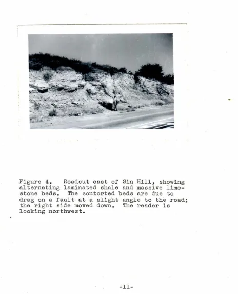
-10-Figure 4. Roadcut east of Sin Hill, showing alternating laminated shale and massive lime-stone beds. The contorted beds are due to drag on a fault at a slight angle to the road;
the right side moved down. The reader is looking northwest.
[image:14.567.47.512.108.682.2]
I t is unsorted very coar se sandstone, well cemented with
noncalcareous cement; i t is usually grey but sometimes reddish.
Solutions from overlying mudflow may hE.ve helped color and
cement the rock. Thickness is 10 to 15 feet.
c.
Upper Sediments11he basal portion, extending to the Andesite laccolith,
is sorted medium sandstone, par~ly cemented by calcium
car-bonate. It is light grey, massive to bedded, and contains
many poorly preserved fossils.
The overlying bed is limestone or marl. I t is oolitic,
massive and in beds abput five inches thick, very hard, and
a yellow brown color. This bed grades into thin laminated
sandy shales with occasional beds of limestone; the latter
beds are shown in figure 4. No good exposures are obtained
between Sin Hi l l and Top.Peak. Refer to figure 6 for a
de-tailed description of beds observed in the roadcut at that
point.
sandstone
Fossils were collected in the basal portion of the Upper
Sediments on the south flank of Sin Hill. However, tentative
identification revealed none were sufficiently limited in
time range to be useful. The following forms were tentatively
identified:
(1) Panope generosa
(2) Macoma nasuta
(3) Metis alta
Cal., Miocene to Hecent
Cal., Miocene to Pleistocene
-12-The Turri tella ocoyana i'auna is the index of the '.ropango
Formation; unfortunately, none of these were found.
D. Interpretation of the Sediments
The Lower Sediments probably represent enroachment of
the sea on a denuded Basement area. The numerous quartzite
fragments in the base of the member probably resulted from
prolonged erosion of the Basement, exposing portions of meta
-sedimentary rocks.
The Middle Sediments were probably stream laid.
The massive. sandstone beds of the basal Upper Sediments
was probably a littoral or neretic deposit along a subdued
coastline, since no basal conglomerate of basalt is observed.
The abundant fossils in a poor preserving medium, coarse
sand, probably represent rapid burial.
The oolitic limestone may derive its structure by
deposit-ing around a silt particle. If this were so,it would indicate
deposition because of super-saturation and thus perhaps an
isolated embayment or sea.
The beds exposed in the roadcut at 'l'op Hil l reveal a
change from a previous calc2.reous environment to a salicious
environment. Possibly shore conditions were al tered such that
precipitation of silica was caused by mingling of fresh and
salt waters.
The section designated Topango is strikingly similar to
the sequence mapped by Hoots in the Eastern Santa_ ·Monica
-13-Mountains; however, the Santa Monica section is much thicker.
The basal quartzite conglomerate is 1000 feet thick; the
Pacoima Hills quartzite conglomerate is only a few tens of
feet. Also the basalt section here is much thinner.
Per-haps this locality lay just at the edge of the basin of
deposition. Roots lists volcanic ash beds as characteristic
of the Modelo formation. Therefore, i t may be barely possible
that the Topango-Modelo contact lies within the Upper Sediments
section. However, for convenience, the entire sedimentary
and extrusive section is designated 'I'opango in this report.
-14-Fi
g
ure 5. Roadcut at Top
H
ill.
-15-Formation
Topango
Mem- Columnar
ber Section 'lhi ckne s s Character
.. ....
14 .. .. . . .. 13 Al t . 2! th. sh. &,.ss.
.. . .
13 . / ...._ - - - 2 Vole. ash.
"'
12 14 Cherty sh. & ss •
..
11 12 Well sorted vy. coarse
ss.
.
carbon at top •; ..
'
~
10
-
.. :.
14 Lam. chert & ss...
.. ..
... ' .
Coarse ss.; bed o:r
- ···-···---·
9 - - - - ---··- - - -- ····-- -·
-
- · 13 fine ash.. . -.
. . .. ·.
-.
v
Gr. fine ash, fract.8 - - - -
-
-
- - - 4 conch. Soapy.7 : .. . ! · ... ·.::: :
...
4.5 Chert; or. ye. ss • 6-
.. --·· . -···.. .... ·- .. .... 7.5 Alt. sh. & ss •...
. . . . ..5 / !\ l Gr. salicious ss.
4 ~:··.:_,.
_
_
15 Gr. lensing hard sh... ' 1st chert.
3 .. 6 Well sorted ang. med.
2 ,__ ... 9 Lam. sh.
·---·-·- ··· ·
-..
1
-
10Lt.
gr. sorted ss. [image:19.566.61.516.56.705.2].•
Figure 6. Columnar Section f0r the Roadcut
at Top Hil l .
GEOLOGIC STRUCTURE
A. Major Anticline
The attitude of strata southwest of Hermes Hill is
north-south, dipping west; in the region of Hermes Hi l l , i t
is east-west, dipping north; on Sin Hi l l i t is north 20
west, dipping north. This variation is interpreted as
repre-senting an anticline or anticlinal dome plunging steeply
north. 'l'his i nterpretation is substantiated by the shape
of the Upper Basal t -Upper Sediments contact at Pony Hi l l .
B., Faults
\
Fi9vre 7
D1sfr/bu-fion of Faults.
I " r e pre senfs
one .fav/f.
The majori ty of faults trend:c.orthward, as seen from the
distribution di agram, figure 7. Figure 8, the structure
sec-tion, illustrated the possible tendency to form north-south
blocks. The block between Herme& Hi l l and Hi Hill has appar
-ently been dropped about seventy-five feet. 'l'he relations
-17-at this point are a result of interpret-17-ation in the field
rather than concr·ete evidence. The block is bounded by
nor-mal faults, the easternmost dipping 64 west.
Mex Fault is apparently also a reverse fault. I t dips
approximately 55 north. Its displacement is approximately
200 .feet if considered a dip slip fault. 'I'he apparent
off'-set is approximately 650 feet.
'l'he Upper Basalt-Upper Sediments contact is offset south
of Sin Hill. t f the following interpretation is correct,
a method of determining relative ages of the north-trending
faults and the east-west trending faults is available:
' · .fa.ulf
1 J f ow d 'fl f''" ,,!
5n«..
-Bed.s on down dr-Pp)"ed s/de
of .favlf ,._,....e no f- nor.v //j:-fed enou9h fCor- c..o>-Y?p/ef..e
.__ re,.,,ov" I.
s oufh of- Sin f--fiff.
Thus i t is possible the east-west .faults are older than
the north-south system.
-18-STRUCTURE
SECTIONS
[image:22.747.84.648.179.435.2]A
N 1.5°£Figure 7
B
N4-2 . .0°E-c.
Other FoldsIf the few isolated attitudes are sufficient evidence,
the varying attitude near Lone Hill represents a syncline
lying parallel to the Major Anticline axis. Also, the
vary-ing attitudes on the ridge east of Sin Hil l may represent
a syncline with the axis trending north. Final ly, the
atti-tudes on Top Hidge may possible be due to an anticline. The
latter two possible structures are idealized in the second
structure section, Figure
9.
I t is e~whasized these otherfolds are purel y conjectural. It might be more realistic
to assume the block structure continues into the sedimentary
section.
D. Structural Development
The foregoing observed structures may be t ied into a
coherent picture as foll ows: The east-west faults may have
been produced at the same time a doming force was operating
upward. The south sides of the east-west faults are observed
to be up with respect to the north. 'l'he auxilj_ary folding,
if such exist s, may have occured as the resul t of outward
horizontal pressure resul ting from the doming. After
cessa-tion of the upward force, collapse may have taken place, with
bl ocks dropping downward along the former line of upward force.
No evidence for dating the above events was obtained.
However, the deformation was probably not connected with the
mid-Pliocene orogeny, because the l atter was the result of
north-south forces acting southward.
-20-GEOLOGIC HISTORY
1. Intrusion of granodiorite into gneissic country rock in
Jurassic or possibly Triassic time.
2. History unknown until denudation of intrusive complex in
mid-Miocene time.
3. Deposition of Lower Sediments by a transgressive sea.
4. Withdrawal of the sea; flow of basalt.
5. Period of weathering followed by stream deposition of
Middle Arkose.
6. Welling up of hot mud from a volcanic vent and deposition
of mudflow containing basalt fragments; immediately following
is flow of Upper Basalt.
7.· Submergence and deposition of Upper Sediments with the
environment gradually shifting from calcareous and elastic
to salicious and elastic deposition.
8. Intrusion of Andesite, forming small laccolith and
dis-turbing beds.
9. Possibly doming resulting from upward forces made the
area emergent and may have separated the mid Miocene Topango
and upper Miocene Modello formations. Upon cessation of
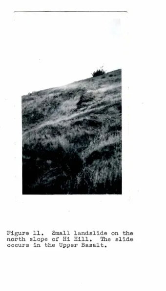
-21-Figure 11. Small landslide on the north slope of Hi Hill. The slide
occurs in the Upper Basalt.
[image:25.566.64.405.82.676.2]-22-upward force, the down-dropped blocks may have occurred.
10. Possible Pleistocene upl ift and then erosion to
approx-present height.
11. Possible formation of pediment (thought to exist in
western portion of area) followed by more recent uplift with
consequent tilting of pediment surface.
12. Continued erosion; small scale l andsl iding.
-23-'
---
---
--
..._---
-.
/ / / /-
--
-..._ -..._---
-..._----
--
---EXPLANAT
I
ON
Seciimentar
y
R..
ooJ<sMade La.nd
Al/vvivm
Tru
Upper ::Je4imen+.s
T-rM
Micid le Ar Ko.s e
Low&r Sediments
f
9neous and Metamorphic Rocf<..s"
TTA
;v.
'-Anclesife Q)
C)
~ I::
I
~~ TTBU Q
&
0~ Upper Ba.s<:Jt ~
TrsL
low er 13asa/f
Faulf.s
Con facts
~ Exc<tva:tion.s
GEOLOGIC MAP
OF
PACOIMA HILLS (CA
.
LI
F.)
"
~·- 't
I>
I,( \1o.-'
-
..
9'4&11 n l
..
lJ '~"J". '
,.,.-,
/
'
/ \ I \
/
I
/
I
I D'
/
I
\-
ry
,I,I
( I
/ /
\
/ /
,
__
_....
~--,. 0 \
" I I • I
\ . / '-
.
' / ,, I....
I''1••
"
~ "-•
,
.
I
I
I
r
II I I I / / / / / / /
.
\
..
..
..
"'
/
\
\
\
I,,...
-
-I
I
' ' I
'