L a n d m a r k s :
Reading the Gove Peninsula
A thesis submitted for the degree of Doctor of Philosophy at The Australian National University
Kitty Eggerking
Declaration
I certify that this thesis in its entirety is my own work and based upon my own re-search. Where I draw on the work of others, it is duly acknowledged.
Kitty Eggerking 18 Jaunuary 2013
Acknowledgments
This thesis has been a long time in the making, and I have no doubt tried the patience of all those who have been involved with its production. Special thanks must go to Paul Pickering, Nancy Williams and Howard Morphy for their advice, encouragement and conversation over the years. Thanks too is due to Mary Edmunds for her support and helpful suggestions early in the process.
I am most grateful too to those institutions and individuals who have provided infor-mation in one form or another. Particular thanks must go to the fantastic and diligent staff of the AIATSIS library, the Northern Territory Research Service and the Berndt Museum of Anthropology. Thanks also goes to the staff of the National Archives in Canberra and Darwin, the National Library of Australia, Museum Victoria, Monash University library, the House of Representatives Table Office and the Art Services de-partment of the federal parliament. I must also thank those who granted me interviews — Robert Ellicott, Ted Egan, Jeremy Long, Barrie Dexter and Colin Tatz. Very early in the piece I also called on Kim Beazley senior. I regret that I was not better informed before imposing upon their time.
Special thanks is also due to all those connected in one way or another with the former Methodist Overseas Mission (MOM) or the Methodist Church, as much for their hospi-tality as their information: to Michael and Evelyn Ellemor for welcoming me into their home to inspect the papers of Arthur Ellemor; and to Betsy Wearing for her generous hospitality and for access to Beulah Lowe’s diaries. I thank Betsy too for organising permission from Stuart Lowe to use the diaries. The volunteers at the Uniting Church Archives were also gracious hosts. I chanced upon others from MOM while visiting Yirrkala in 2004 and all had wonderful information to offer: Wally and Jill Falwell, Ber-nie Clarke and Jack Goodluck.
I also thank Leon White for making that visit possible and for his valuable insights. Others who were enormously helpful during my stay at Yirrkala were Katrina Hudson and the late Dr Marika. I thank Frances Morphy for translating a recording of Gawarrin Gumana. Further thanks go to Katie Haynes, Ursula Frederick and Pip Deveson for technical support; and to Lan Tran for her forbearance.
Abstract
This thesis investigates the events leading up to and including the first land rights case, Milirrpum v Nabalco, heard in the Northern Territory Supreme Court before Justice Blackburn in 1970. It examines how the Yolngu people of the Yirrkala mission responded to the federal government’s leasing of the Gove Peninsula for the mining of bauxite, initially by seeking a political solution and subsequently legal redress. Thus, it considers events such as the bark petitions the people of Yirrkala sent to the federal parliament in 1963 and the subsequent inquiry by a select committee of the House of Representatives into Yolngu grievances. While these events are reasonably well known, the thesis situates them in fresh and appropriate political contexts. For instance, it takes into account the instability of the Menzies government in 1963; and, further, it exam-ines the relevant parliamentary standing orders to show that the bark petitions were in order but the then Minister for Territories was out of order in ‘rejecting’ the first peti-tion.
As well as these known events, the thesis also brings to light many other hitherto unreported events and matters. These events — and especially the actual Gove case — represent key moments for inspecting the contest of Indigenous and non-Indigenous systems of knowledge or world views, and this is the key reason for undertaking the study. To chart a course through the two disparate traditions, much of the focus is on the ways that land is conceptualised.
Contents
Acknowledgements iii
Abstract iv
Illustrations vi
Abbreviations vii
Prologue 2
Chapter 1: Marking out Arnhem Land 11
Chapter 2: Father knows best 45
Chapter 3: Protesting by petition 65
Chapter 4: Grievances aired 89
Chapter 5: Changing course 120
Chapter 6: A fresh perspective 152
Chapter 7: Dissecting a trial 181
Epilogue 213
Appendices 223
Illustrations
Yirrkala church panels 1
1.1 Flinders’ map 13
1.2 Warner’s map 15
1.3 Spheres of church influence map 17
1.4 Map of Arnhem Land at the time of gazettal 17
1.5 Thomson’s map 22
1.6 Brown paper map of Melville Bay (Sheet H) 39
1.7 Mawalan’s drawing of Melville Bay 41
2.1 Map of various Gove SMLs 61
2.2 Map of excision and mission lease 63
3.1 Wells’ map 67
3.2 Dhuwa petition (14/8/63) 77
3.3 Yirritja petition (28/8/63) 77
3.4 Thumbrpints 85
4.1 Map provided to Wells by Calwell 99
4.2 Map used during the Select Committee hearings 109
5.1 Berndt’s reference map (1964) 123
5.2 Wandjuk’s map reassembled (1964) 123
5.3 Inviolate areas (1964) 125
5.4 Areas available for exploitation (1964) 126
5.5 Composite map (1946) 127
5.6 Moiety and clan holdings (1964) 128
5.7 Moiety and clan holdings (1946) 128
5.8 Sites associated with Djambawal and Wuyal (1964) 129 5.9 Sites designated secret, sacred, dangerous (1964) 131
5.10 Stone outlines at Wirrawirrawoi 138
5.11 Approximate location of Evans’ 18 sites 139
5.12 Segment of Griffin’s map 144
5.13 Card of Dhanburama 149
5.14 Photo of Dhanburama 149
6.1 1968 petition 157
6.2 Berndt’s large affidavit map 178
6.3 Berndt’s small sketch map 178
7.1 Survey map 191
7.2 ‘Dividing’ country 200
7.3 Webb’s map 207
7.4 Warner’s map 207
7.5 Blackburn’s map 210
8.1 Looking towards Pt Dundas 219
8.2 Wirrawirrawoi sign 219
Abbreviations
AIAS (later AIATSIS): Australian Institute for Aboriginal (and Torres Strait Islander) Studies
ALP: Australian Labor Party BAC: British Aluminium Company CAA: Council for Aboriginal Affairs CP: Country Party
CPD: Commonwealth Parliamentary Debates (Hansard)
FCAA (later FCAATSI): Federal Council of Aboriginal (and Torres Strait Islander) Advancement
GBC: Gove Bauxite Company HR: House of Representatives IDC: Inter-departmental committee LP: Liberal Party
MCAA: Methodist Commission on Aboriginal Affairs MOM: Methodist Overseas Mission
MTS: Milirrpum transcript
NAA: National Archives of Australia NLA: National Library of Australia NTA: Northern Territory Administration NTRS: Northern Territory Research Service OAA: Office of Aboriginal Affairs
SC: Select Committee
SCR: Select Committee Report SCT: Select Committee Transcript SMH: Sydney Morning Herald SML: Special Minerals Lease
Declaration
Prologue
The wondrous paintings on the preceding page were completed in early 1963 for in-stallation in the new church at the Yirrkala mission, at the very tip of north-east Arn-hem Land. They serve as a splendid introduction to Yolngu culture and to the events described in this thesis. Before providing a brief description of these church panels, it is necessary to say a little about the Yolngu universe. Everything in that universe is as-signed to one of two moieties. The sun, the morning star, the water goanna, the stringy-bark tree, for example, all belong to the Dhuwa moiety; the moon, the evening star, the stingray, the cycad palm are all said to be of the Yirritja moiety.1 People and country, too, are of one or other moiety. This is not to say that the world, and everything in it, is in eternal dualistic opposition; rather, in the Yolngu world, the Dhuwa and the Yirritja complement each other and are thoroughly intermeshed. In short, everything in the Yolngu world is linked to every other thing in an intricate web of inter-relationship. Thus, the painting on the left is by eight Dhuwa artists from six clans; the one on the right by eight Yirritja painters from five clans. Each panel depicts a series of major cre-ation stories of ancestral beings or wangarr important to that moiety. To begin with the Dhuwa panel: the lower half describes the journeys of the Djang’kawu, who are often portrayed as a brother and two sisters. The Djang’kawu yearned to investigate a cloud bank on the horizon and so made preparations to leave their usual home, Baralku, the Dhuwa island of the dead. They were guided on their journey across the sea by the Morning Star, Banumbirr. They were constantly heading for the cloud bank, here represented by its maker, Thunderman or Djambawal — the very dark single figure who looks to be holding a shield above his head, but it is a thunderbolt he is preparing to hurl. The Djang’kawu sang as they paddled their canoe; sometimes the seas were rough; sometimes they encountered different sea creatures. Eventually they made landfall near Yalangbara, where they rested. Here they pierced the ground with their digging sticks (mawalan) and brought water and many life forms forth from the earth. The remaining sections of this panel describe how the Djang’kawu travelled about north-east Arnhem Land, animating the land with all manner of life and endowing it with both meaning and names for other Dhuwa clans, such as the Galpu, the Djapu, the Djambarrpungu, the Marrakulu and the Datiwuy.
Artists from the clans just named, together with those from the Rirratjingu clan, worked individually on different sections of the Dhuwa panel. Mawalan, Matha-man and Wandjuk worked on the Rirratjingu sections portraying the travels of the Djang’kawu from Baralku to Yalangbara. Mawalan was the recognised leader of the Rirratjingu clan at the time, and he — together with his son Wandjuk and his younger brothers Mathaman, Milirrpum and Dadaynga — feature prominently in the events under consideration, and that is the reason for introducing them here.2
1
See, for example, Hutcherson 1995.2
Mawalan and Mathaman had the same father, but different mothers. Milirrpum andDadaynga had the same mother and father — and their father, Dhurryurrnga, was the brother of Dhuwakan, the father of Mawalan and Mathaman. The four brothers use the surname of Marika, which was their paternal grandfather’s name. The other painters were: Gungguyyama Dharmarrandji (Djambarrpuyngu); Larrtjanga Ganambarr (Datiwuy); Munuparriwuy Wanambi (Marrakulu); Mutitjpuy Mununggurr (Djapu); and Mithinarri Gurruwiwi (Galpu).
In the lowest sections of the Yirritja panel three wangarr can be discerned. Banaitja, Galparimum and Lany’tjung moved through parts of the country, imbuing it with life for Yirritja clans.3 These wangarr first gathered at Gangan and then spread out through Yirritja country, dispensing rangga (sacred objects), miny’tji (sacred designs) and songs as they went. These wangarr occupy the bottom third of the panel, which was produced by the Dhalwangu artists Birrikitji, Gawarrin and Yanggarrin, whose country is cen-tred around Gangan. The middle section depicts Wirrili, who brought language and pigments to the Gumatj clan. Alongside him stands Murriri, who brought fire to that clan. These wangarr share the country around Caledon Bay, though Wirrili is associated with stony, dry country and Murriri with paperbark-swamp country — country that is depicted immediately above these two figures. This section is by the Gumatj painters Mungurrawuy, Djarrkudjarrku and Watjun. Mungurrawuy Yunupingu was considered head of the Gumatj clan at the time and, like Mawalan, he appears frequently in the events discussed.
The story for the top third of the panel is that of the Manggalili clan and was painted by two brothers from that clan, Narritjin and Nanyin Maymuru. It focuses on the Djar-rakpi area of Blue Mud Bay and tells the story of Ngulumun, who gave the clan their language. To his right is the woman Nyapilingu, who is sheltering under some sheets of paperbark against heavy rain. She is credited with showing the clan how to make possum string.
Running up through the Yirritja panel appears to be a series of mortuary logs. In the Manggalili section of the painting the column of logs is said to become ‘the Tree of Life’, and the possums that scurry up and down are reported to be conveying messages between heaven and earth.4 At the top of this tree sits the chief messenger, the guwark (koel cuckoo), and this top panel represents the heavens. While many versions of the stories depicted in the two panels are possible, I have relied primarily on Ann Wells’ This is Their Dreaming: Legends of the Panels of Aboriginal Art in the Yirrkala Church (1971). Mrs Wells recorded these stories at the time the paintings were being created, but, as the wife of the superintendent at the Yirrkala mission, she was given versions of the stories that the painters wanted her to record. I suspect she may have taken some liber-ties in describing the column in the Manggalili section as the tree of life and in attribut-ing messenger status to the possums, but otherwise her account seems quite consistent with what the painters told her. Other versions of the stories and other representations of the wangarr are always possible, depending on the context, the potential audience and the teller.
The paintings illustrate most eloquently a fundamental certainty of Yolngu cosmol-ogy: that everything — plants, animals, people, language — comes initially from the land, and everything was created from the land and emplaced in the land by wangarr. It will be noticed that the Yirritja panel carries many diamond shaped designs, while the Dhuwa panel has a preponderance of striations. These are the miny’tji or sacred designs given to each clan by wangarr. Anyone who has had a thorough Yolngu educa-tion would know not only to which clan the miny’tji belong but also to which country
3
These ancestral beings are sometimes collectively known as Barama. Cawte (1993, p. 39) on the other hand suggests that the four entities are brothers.the miny’tji refer. As Howard Morphy says, miny’tji are handed down from generation to generation, thereby ‘maintaining a continuity over time in the relationship between land, clan and the ancestral past’.5 With the exception of the Manggalili section, the two panels refer to country within about a 50-kilometre radius of the Yirrkala mission on the Gove Peninsula.
Having just alluded to Yolngu education, this is the appropriate moment to say a little more about that style of education. Children are taught progressively: they learn first the ‘outside’, public or superficial, stories; if they show aptitude and if they are judged ready by others to know, they gradually learn more and more about the ‘inside’ or deep ways of the world. In other words, knowledge in and of the Yolngu world is cumulative, compounding and revelatory. Knowledge is also always tailored according to a person’s experience and according to the situation, and knowledge includes correct discernment of such things. Knowledge, moreover, is never simply there for the taking. It should also be noted that every Yolngu person is born into a particular clan, either Dhuwa or Yirritja. A man always remains in his birth clan — the clan of his father — in his given moiety, but a woman marries into a clan of the opposite moiety, even while remaining a member of her original moiety and clan. Thus, everyone’s mother is of the moiety opposite to the one into which her children are born, and thus every Yolngu person comes to learn about the Dhuwa world and the Yirritja world, and how every-thing in those two worlds connects, even while only publicly expressing knowledge of their own moiety.6
***
The church panels make the perfect preface to this thesis, both literally and metaphori-cally, since they usher in a series of extraordinary events that culminated in Australia’s first, though unsuccessful, land rights case, known informally as the Gove case of 1970. The panels were painted at a time when mining companies had begun to explore for bauxite on the Gove Peninsula. Yolngu responded to this intrusion by demonstrating that it was their country in various ways, one of them being the church panels. Since no one in a position of white authority saw fit to inform — let alone consult — them about the developments, Yolngu took matters into their own hands. As Gawarrin Gumana recalled in 1997: ‘The church was strong against us doing anything … . The government didn’t believe we [had] culture, land, sacred painting. They didn’t want us to make it explicitly known in public.’7 According to Gawarrin, the time had come when the ‘old men thought we should make explicit miny’tji’ so that Europeans would ‘understand how we were living and where we came from’.8 The miny’tji (clan designs) are, as already suggested, seen as ‘part of the sacred law (madayin)’ of each clan and are also a clan’s ‘charter for the land’, a point to which I return below.9 Sutton makes the powerful point that:
5
Morphy 1991, p. 170.6
This very brief description of Yolngu social structure is taken from Williams 1986, Chapter 2; Morphy 1991, Chapter 3; Keen 1994, Chapter 2.7
Gumana 1997. The recording was made by Francis Goode from the Oral History sec-tion of NTRS on 24/3/1997. It was recorded at the request of Gawarrin and other old men in Yolngu matha.8
Gumana 1997.9
Morphy 1991, p. 170.
The political control of the land and religious control of sacred designs or other symbols were, as far as we can tell, typically inseparable in indigenous Australia so long as ancient traditions persisted.10
This thesis is at core a history of events at Yirrkala from 1963 to 1971, beginning with the bark petitions — the inspiration for which came directly from the church panels and which brought Yolngu grievances to national attention — and ending in Justice Blackburn’s unfavourable decision in the Gove case. One of the key interests in pursu-ing this history is to come to an understandpursu-ing of how the Yolngu of Yirrkala, so re-mote from the centres of power, first sought a political solution to their grievances and subsequently turned to the law for a remedy. Their quest for a political solution occu-pies Chapters 3 and 4, while the legal route is considered in Chapters 6 and 7. Chapter 5 is the turning point between the two institutional modes of redress.
Those inclined to think this too narrow a focus will be surprised to learn from Bain Attwood that ‘[l]ittle has been written by historians’ about these events, although an-thropologists and lawyers have covered some of this ground.11 Those who have written about these events — including Nancy Williams, Howard Morphy and Marc Gumbert — did so at a time before many documents were available in the national archives, and so I, coming late to the field, have had access to an extraordinary array of material that eluded these earlier researchers. I depart from the existing literature in another way, too: I try to account for institutional practices by reference to their salient internal rules. Thus, in considering the reception of the bark petitions in the House of Represen-tatives, I pay attention to its standing orders of that time and weigh the testimony of witnesses in the Gove case against some of the rules of evidence for the court.12
Yirrkala is a world away from Canberra, Melbourne and Darwin, and yet I try to draw these various places together into the one theatre of action. I try also to bring the vari-ous players — Yolngu, politicians, bureaucrats, missionaries, anthropologists and law-yers — together on the one stage. I try too to situate events in their appropriate political context. For instance, while others have noted that the bark petitions were the first to give rise to a parliamentary inquiry, it has so far escaped attention that the inquiry was only instituted because the government of the day lacked the numbers to prevent it going ahead.13
As well as inspecting these and other events of the 1960s, I try to show the ways Yol-ngu and YolYol-ngu country have been inscribed in various European records — policy documents, learned monographs, letters, newspapers, memoirs, transcripts and maps — over a more extensive time frame, but with heavy abridgement. I do this to show the ways white knowledge about Yolngu and their country had accumulated and was being deployed by the early 1960s. Such matters are addressed in the first two chap-ters. This historical sketch not only provides the appropriate context for considering the events of the 1960s, but the historical background and the events together lay the groundwork for understanding how various knowledge claims, European and Yolngu,
10
Sutton 1998, p. 399.11
Attwood 2003, p. 395.12
Whenever I have nominated ‘the first land rights case’ as the subject of the thesis, theinquirer generally presumes I am working on the Mabo decision or the Gurindji struggles —
surely sufficient reason for the thesis.
were displayed and played out in the timeframe under consideration. It is this contest between different knowledge systems that is the motivation for undertaking this re-search, and there is much in this clash of thinking that warrants serious attention. I have been at pains to make this a genuinely inter-disciplinary and inter-cultural study, one which, among other things, carefully examines the encounters between Yolngu and the Europeans who observe, describe or regulate Yolngu lives — anthro-pologists, politicians, missionaries and bureaucrats — that are thrown up by the ar-chives. In large part, however, I am forced to rely on ethnographic accounts, not only because these are the first extensive descriptions of the north-eastern corner of Arnhem Land, but also because, until the 1950s, anthropology was the predominant influence on government policy in the domain of Aboriginal affairs and was seen as a desirable prerequisite for anyone wishing to work as a patrol officer or a missionary. Moreover, much was ultimately made of ethnographic knowledge in the court case: in fact, it is in the Gove case that anthropologists make their first appearance as expert witnesses. Much of the anthropological writing at least until the 1960s focused primarily on Yolngu social organisation and portrayed Yolngu society as preoccupied with religious matters and as unchanging or static.14 Until the 1960s there was a tendency, as Martin Nakata notes, to write about Indigenous peoples as ‘people of the past’, people who seemed to have no connection with the present, who did not look towards the future and whose culture was static and traditional. Such representation is ‘the very act of denying [Indigenous people] as actors in their own present’.15 It is an attitude that is ex-hibited by the politicians, the bureaucrats, the mining executives, some of the mission-aries and only occasionally the anthropologists who cross these pages. It was such an attitude that went hand-in-hand with the notion that people of the past were doomed, could not survive into the future and so were in need of protection. A similar sentiment — which often goes under the banner of ‘before it is too late’ — can be found as the ra-tionale for establishing institutions like the Australian Institute for Aboriginal Studies, and it certainly was the motivation behind many collections of material culture. No doubt it was this perception of ‘an aboriginal inability to grasp the European plan of life’16 that prevented many of the Europeans who had dealings with Yolngu from either informing or consulting Yolngu about plans to mine the peninsula. To treat peo-ples as relics of a bygone age is to forget that they live in the here and now, grappling with choices and decisions in their daily lives. Such treatment, according to Nakata, runs the risk of ‘submerging’ these supposedly static peoples in someone else’s history and displacing them from ‘the centre of their own lives’.17 Nakata advocates a read-ing of the record that reinstates Indigenous people at the centre as actors by carefully listening for their voices, by taking their concerns seriously and by detailing the context in which things happened.
In reading the record about Yirrrkala, I find numerous traces of Yolngu individuals, and in this account I try to create space for Yolngu to be actors in their own stories
14
See, for instance, Stanner 1968, pp. 38-40.15
Nakata 2007, p. 204.16
Stanner 1968, p. 47.17
Nakata 2007, p. 202. In the quote I have substituted ‘Indigenous people’ for his original ‘Islanders’.and try to show how they actively made sense of encroachments upon their world. In other words, this is to be a history against the grain or, in the words of Greg Dening, ‘a two-sided history’, even while relying, for the most part, on documents from one side.18 To redress the imbalance, I use documents from the other side wherever possible — and this is another reason for according the church panels prominence here. There is af-ter all, as W.E.H. Stanner observed, ‘stuff in aboriginal life, culture and society that will stretch the sinews of any mind which tries to understand it’.19 One casualty of reading against the grain is, however, that many of the commentators and chroniclers I scruti-nise do not emerge from such a reading with their reputations unsullied. It is a direct consequence of the way they represented, misrepresented or even defamed Yolngu. ***
The Yirrkala church panels are charters to Yolngu land, which was given or entrusted to Yolngu by various wangarr. They can also be read as maps and histories of north-east Arnhem Land. Even if one is not knowledgeable in the ways of Yolngu painting, one can still derive aesthetic pleasure and get some feel, albeit superficial, for what is being expressed in the panels. With written documents, however, one needs a basic knowledge of an alphabet in order to catch even a glimpse of what is going on. To the uninitiated, painting is open; writing is closed. (Of course, it is generally supposed that, once the alphabet has been mastered, written knowledge is universally available.) In painting, or in music for that matter, knowledge is non-dogmatic in nature and amena-ble to a range of interpretations or readings. In one painting a whole world can be silently conjured, and in painting there is always the possibility that deeper meanings will eventually be divulged. A picture does in fact convey meaning — or at least the impression of meaning — better than any thousand words.
The church panels were designed not only to assert Yolngu knowledge, but also to in-vite an exchange of values between Yolngu and European knowledge.20 The panels are a sign that Yolngu people were determined to take matters into their own hands and in the process to demonstrate or to assert their culture and their land to all European comers — the mission, the government and the mining companies. To support these broader political aims, Yolngu were keen to demonstrate and promote ‘the underlying unity of the clans’,21 since ‘a united front’, it was believed, would be expedite negotia-tions between Yolngu and Europeans.22 The panels are an assertion of Yolngu values; they can further be read as an invitation to a dialogue and as a plea for help. Above all, the church panels will serve as a useful reminder, a touchstone, of Yolngu agency in the course of this thesis.
To read and to write is to know how many words are expended on the simplest de-scription or explanation, how many are squandered on necessary but tedious scene setting. It is also to learn how circuitous and even duplicitous writing can be. To read the records I have read is to know that writing does not guarantee either ‘truth’ or
cer-18
Dening 1998, p. 41.19
Stanner 1968, p. 41.20
Morphy 1998, p. 239.21
Morphy 1998, p. 246.tainty, as it was once reputed to do, any more than the spoken word. It is as if Thamus’ prediction (and Plato’s prejudice) has come true: that writing is the ‘recipe’ for giving people the appearance of being ‘very knowledgeable when they are for the most part quite ignorant’.23 Like any other act of communication, the written word can be partial, fallible and incomplete; it too is susceptible to persuasion, self-justification, self-delu-sion and myth-making. Many of these dubious qualities are exposed in the course of this thesis.
For too long the written word has been held to be the distinguishing feature and the hallmark of Western knowledge, the thing that separated ‘us’ from ‘them’; that marked ‘us’ as civilised and them as ‘uncivilised’; that made ‘our’ knowledge authoritative and gave us authority over ‘them’. It made our knowledge superior to theirs. One only needs to consider parables such as Homi Bhabha’s ‘Signs taken for wonders’ or Lévy-Strauss’s ‘A Writing Lesson’ to know that this was supposedly the case and to know the awe in which the ‘natives’ apparently held writing.24 It was also generally accepted that because they lacked writing, they lacked documents and therefore lacked history as well. We have solid, factual history; they have only unreliable memory, myths and legends. The point is now generally conceded that we Europeans judge other cultures by different criteria, standards that we set and that we hold do not apply to our own cultures. Any deficiency or lack detected in another or alien culture is not so much about what ‘they’ lack as about what ‘we’ have come to possess or achieve — or even to have borrowed, usually without acknowledgement, from some other culture. Any supposed deficit is only a means for assessing the relative positions occupied by us and them on the evolutionary ladder, and the distance between. Any such deficiency is, according to Sahlins, ‘inspired by theoretical conceits of progress’.25 It is an attitude, a teleology and a mantra that goes hand-in-hand with that other European conceit that parades by the name of positivism, which, mercifully, has been in full retreat for quite some time now.
To attempt to work in an intercultural way I find maps a convenient device; they provide a useful, alternative means for steering a course through disparate knowledge claims. For a long time, maps were another of those things, like the written word, that were supposed to separate ‘us’ from ‘them’. In some quarters, they were regarded as the very model for scientific method — the perfect and impartial representation of the real world on paper. It is perhaps from this vision of mapping that Geertz draws his analogy of the cartographer as the consummate scientist,26 an analogy that I exploit in the first chapter. But as geographers and others have turned their attention to theories of a literary, postmodern or poststructuralist bent, this vision of mapping has begun to slip from view.27
Thus, James Corner notes that while maps and mappings have been taken, for instance,
23 Plato (1973), Phaedrus, p. 96. In this translation, by Walter Hamilton, ‘receipt’ is used instead of ‘recipe’, which much better conveys the double sense of ‘remedy’ and ‘poison’ that
Derrida detects in Plato’s word, pharmakon (1981, p. 97 ff).
24
Bhabha 1994, pp. 102-122; Lévi-Strauss 1976, pp. 385-399.25
Sahlins 1993, p. 25.26
Geertz 1988, p. 10.27
See for instance Harley 2001, and particularly his essay, ‘Deconstructing the Map’.as means for enhancing the imperialist cause, they can also be seen as ‘instrumental in the construing and constucting of lived space’. ‘In this active sense,’ he continues, ‘the function of mapping is less to mirror reality than to engender the re-shaping of the worlds in which people live’. He writes about the ‘agency of mapping’ to convey ‘the ways in which mapping acts may emancipate potentials, enrich experiences and diversify worlds’.28
Maps make great conceptual tools and are made for metaphors, the most beguiling of which is surely that any map may ‘be regarded as a hinge around which pivot whole systems of meaning’.29 It comes from geographer Denis Cosgrove, who further regards mapping as both ‘a form of literacy’ and a ‘sign of civilization’.30 Maps and mapping are, moreover, activities fundamental to any society.31 While ‘all cultures map’, as Wystan Curnow notes, a particular culture may fail to recognise the ‘mapping code and the assumptions that informed its use’ deployed by another culture. Curnow here is speaking about a dispute that arose between Maori and the Crown over the terms of sale of much of New Zealand’s South Island. In this case Pakeha had failed to ap-preciate that the territories they presumed to be unchartered ‘already had their maps’ — ‘complex oral maps embedded in genealogy, legend and ideology, and sustained by memory and ritual, which took literary rather than visual form’.32 In the Yolngu case, their maps are both literary and visual.
I make much of two sets of Yolngu maps that were drawn 18 years apart for Ronald Berndt. The information differs greatly from one set to the next, largely due to the vari-ation in both Berndt’s interest and Yolngu purpose over the years. Every Aboriginal map, like every ceremony, is a ‘unique performance’, as Sutton observes. ‘While ele-ments of both maps and ceremonies may remain constants, their selection and combi-nation in each case is always likely to be event specific’.33 In the case of the second set of maps, drawn in 1964, Yolngu were intent on showing the deep and abiding signifi-cance of land that had been excised for mining. The two series of maps drawn for Ber-ndt are the third pair of landmark documents — along with the church panels and the bark petitions — considered in this thesis. Only Yolngu will have a complete grasp of the meaning of these twinned documents, because, as Veronica Strang puts it, they ‘rely almost entirely on highly condensed symbols, which, with their many layers of encod-ed meaning, require a cultural context and oral exegesis’.34 While it is true that the three sets of documents were made in part for a non-Yolngu audience, they were not intend-ed to be completely accessible to that audience. Much has been made of the symbolism of both the church panels and the bark petitions, but in this work I deliberately focus on their more prosaic meanings.35 The maps, however, have almost entirely escaped
28
Corner 1999, p. 213.29
Cosgrove 1999, p. 9.30
Ibid., p. 8.31
Turnbull 2000, p. 95.32
Curnow 1999, p. 254.33
Sutton 1998, p. 399.34
Strang 1997, p. 222.attention. Berndt’s 1964 article — which is based on the second mapping exercise and is the only published reference to the 1946 mapping exercise — is reasonably well known, but nothing has previously been published on that earlier exercise. From studying the 1946 maps for the Gove Peninsula, I conclude that their main purpose was to inform Berndt on major sites of the Macassan trepanging industry.
Many other maps and references to mapping feature in this work. There are questions asked of missionaries and anthropologists about maps, and questions put to Yolngu about reading maps. In fact, the first question asked of the first Yolngu witness in the Gove case was: ‘can you read a map?’ There are also maps drawn and annotated by explorers, anthropologists, missionaries and miners; and maps etched into the earth as miners performed their surveys with bulldozers. Maps and other ways of representing the landscape — songs, stories, photographs, ceremonies, naming practices, resource inventories and so on — bring the land ‘within cultural boundaries’, not only turning it into landscape, but also, as Strang says, ‘providing ways of holding and, sometimes, colonising the land’. Such representations of country can be both ‘objects of meaning’ and ‘tools for negotiation’.36
The Gove Peninsula lies at the north-west edge of the Gulf of Carpentaria, extending south to Port Bradshaw or Yalangbara and bounded on the east by Melville Bay and the Arafura Sea in the north. The area under examination in this work lies between Melville Bay and Dalywoi Bay. It is exquisite country of white beaches, turquoise seas and everywhere the rocky red soil that is in fact bauxite.
36
Strang 1997, p. 217.Chapter 1: Marking out Arnhem Land
I
‘Seamanship and authorship make too great an angle with each other,’ Matthew Flinders mused four months into his long voyage to Port Jackson. ‘[T]he further a man advances upon one line the further distant he becomes from any point on the other.’ Flinders may have had confidence in his seafaring abilities, but his literary skills were at the time untested. So, on this second voyage to the colony in 1801, Flinders wrote home to his cousin Willingham Franklin, seeking to enlist him in what Flinders imag-ined would be a grand literary enterprise. Together they would write the final account of the great quest that lay ahead: the charting of the unknown coasts of Terra Australis, a project that entailed the staggered circumnavigation of the continent. In the event, Flinders, deprived of seafaring, honed his penmanship during the six years he was forcibly detained on Mauritius and so no longer required the services of Willingham.1 Some two centuries later, American anthropologist W. Lloyd Warner found himself em-barking on another enterprise of almost imperial proportions: his would be one of the first studies in an elaborate program designed by A.R. Radcliffe-Brown, the foundation Professor of Anthropology at the University of Sydney (1926-1931), to map the social organisation for every Aboriginal ‘tribe’ whose kinship structures remained relatively undisturbed by the European colonisation of Australia.2 Like Flinders, Warner could not predict with any confidence what he might encounter, but, like Flinders, he pre-pared for his travels as thoroughly as possible to meet any eventuality.
Flinders equipped himself with ‘every chart at the Admiralty which related to Terra Australis and the neighbouring islands’, the accounts of previous expeditions to this part of the world, and all the paraphernalia needed to make his survey — chronome-ters, sextants, quadrants, telescopes and so forth.3 No doubt Warner also carried com-pass, maps and other equipment needed to survive three years in the wilderness, but, more importantly, he took with him the concepts of his anthropological antecedents — Lowie, Radcliffe-Brown, Malinowski, Durkheim, Mauss and others.4 These were the real and only tools of his trade; they would serve to orient and ground him in carrying out his fieldwork; they would set the pattern and tenor for what Warner in turn would write.
Like Flinders too, Warner would refine the raw material gathered in the field into a seamless and authoritative account only later, in the comfort of his home. Flinders’ account, written after finally returning to England in 1810, brims with navigational and other scientific detail, but, for all this, it remains highly readable and transpar-ent. Readers get a sense of Flinders the man — some may object he makes himself too apparent — his preparations and his encounters with others. To give one brief example: in his meeting with Pobasso, a Macassan captain, Flinders has no difficulty in recording that discussion was made possible only through the translating efforts of his Malayan
1 The quote is extracted from a letter from Flinders to Franklin, 27/11/1801, Estensen 2002, p. 79.
2 Elkin 1956, p. 250.
Fig 1.1: Portion of Flinders’ map showing Melville Bay cook.5 Even though Warner’s eventual account, A Black Civilization, makes for engaging
reading, the reader rarely catches sight of Warner or his travels. We are not told how he lived or how he gathered his information. While his book is shot through with direct quotations from ‘informants’, such people are rarely named and their speech is report-ed in fluent and idiomatic English.6 Readers are given to understand that Warner was fully conversant in the language of the Murngin people he studied and that he accu-rately recorded and translated their discussions. The direct speech may enliven War-ner’s work, but his book is otherwise a model for the way science is (or was) supposed to be written — informative, impersonal, accurate, dispassionate: in a word, objective. I have chosen to begin with this fanciful juxtaposition of Flinders and Warner not only to draw attention to some peculiarities of writing that will emerge in the course of this chapter, but also to suggest that the journeys of these two men do intersect, spa-tially at least, in the north-east corner of Arnhem Land. For both Flinders and Warner Arnhem Land was a blank canvas: their mission was to fill their resulting pages with features and names, and to offer descriptions of what they found to readers far away. The accounts offered by Flinders and Warner were the first in the respective fields of geography and anthropology to reveal Arnhem Land to English-speaking audiences. This chapter concerns subsequent efforts to embellish and emend those first accounts — efforts designed to augment European knowledge of Arnhem Land and its people. In short, such efforts were, as we shall see, intended to put Arnhem Land squarely on the map or, as James C. Scott is fond of saying, to render it ‘legible’.7
To begin this account of the unfolding of Arnhem Land then, I want briefly to consid-er the country as Flindconsid-ers encountconsid-ered it, beginning with its name. The earliconsid-er Dutch accounts gave various suggestions for the origin of Arnhem Land, but the version Flinders favoured linked the name to the yacht Arnhem, which had visited the area in 1623 under the command of Jan Carstens.8 Flinders’ mission for this part of his expe-dition was ‘carefully to examine the Gulf of Carpentaria and the parts to the westward thereof, between the 130th and 139th degrees of east longitude’ — in other words, to survey the entire northern coast of what is now the Northern Territory.9 By 11 February 1803, Flinders had almost completed his clockwise circuit of the gulf; he was nearing ‘the eastern extremity of Arnhem’s Land’, and finding no name for the promontory on his Dutch map, he named it Cape Arnhem. (He would later honour his Dutch prede-cessors in similar fashion with the naming of Arnhem Bay.) He noted the surrounding country as ‘no where of much elevation’ and, some hours after rounding the headland, reported the ‘furthest land visible’ as two flat-topped hills. He named the nearer and steeper of these hills Mt Dundas, the other Mt Saunders. Two days later he sailed into a bay lying under the western flank of Mt Saunders, pronouncing it ‘the best harbour we found in the Gulph of Carpentaria’, even while failing to recognise Cape Arnhem
5 Flinders 1814/1966, V.2, p.229.
6 A notable exception was a man Warner called Mahkarolla, whom he described in his
preface as ‘one of the finest men I have had the good luck to count among my friends’. Warner
wondered ‘at the futility of so-called progress when I think of him’ (1958, p. x) and recorded Mahkarolla’s life story in detail in Black Civilization.
7 Scott 1998, Seeing like a State.
8 Flinders 1814/1966, V.1, p.x; Estensen 2002, pp. 246, 263.
9 Flinders 1814/1966, V.1, p.10. He did not survey the whole northern coast: after leaving the Wessel Islands he headed north-west for Timor (V.2, p.248).
as the western gateway to the gulf. Since the bay did not appear on the Dutch chart, Flinders named it Melville Bay ‘in compliment to the Right Hon. Robert Saunders Dun-das, Viscount Melville’, who by this time was the first Lord of the Admiralty. For good measure, he named the sandy point at the eastern entrance to the bay Point Dundas. He did not record in whose honour he named the prominent headland within the bay Drimmie Head.10
Flinders and his crew spent three days in Melville Bay, making brief forays into the surrounding countryside. He and his ‘botanical gentlemen’ reported that there ‘did not appear to be any rich soil on the borders of the bay’, though ‘on the south and eastern sides the country was covered with an agreeable intermixture of grass and trees, and better adapted for cattle than any I have seen in so low an altitude’. Flinders comment-ed favourably on the diversity and abundance of local fauna and on the geology. He described the garnets he found as large, of ‘a plum-pudding like appearance’, which, if polished, would be beautiful. He noted ‘a tolerable supply of fish’, firewood and fresh water, which could be obtained from ‘a hole made there by the natives’. Flinders did not encounter any of the local inhabitants here — though he had encountered some Yolngu previously at Caledon Bay — but ‘as dogs were seen twice, it is possible the natives were watching us at no great distance’. Here too he detected ‘traces of the same strangers’, the Macassans, he had come across earlier at Blue Mud Bay and Caledon Bay. A day’s sail from Melville Bay, Flinders would come face-to-face with Pobasso.11 The scene conjured by Flinders of Melville Bay seems calculated to stimulate the imagination of readers into believing that everything lies, like a vast empty stage or an unpolished gem, in readiness for European action. The earliest attempts by Europeans to settle and exploit the Northern Territory were to prove unsustainable, and in the next section I offer an assessment of how things stood in the early 20th century, when the Commonwealth assumed control of the territory. Here it is worth noting that when Lloyd Warner arrived to begin his fieldwork in 1926 he nominated as the only achieve-ments of ‘white civilization’ the Overland Telegraph, linking ‘white Australia with the
10 Flinders 1814/1966, V.2, pp. 223-224. In addition, he gave the name Melville to the island that is now called Bremer Island or Dambaliya.
Fig. 1.2: Warner’s map of Murngin tribes (1937) rest of the British Empire’ via ‘the tiny isolated town of Port Darwin’ and ‘a melancholy
and profitless effort to implant its own markings in the form of cattle ranches’ on the southern reaches of Arnhem Land. For Warner, Arnhem Land remained ‘that almost blank space on the map which extends from the Gulf of Carpentaria to the Indian Ocean’.12
Based some 200 kms to the west of Melville Bay at the Methodist mission at Milingimbi, Warner’s impression of his immediate surrounds was less favourable than that of Flinders. He noted that the ‘long flat’ coastline was broken by groves of tea tree, which were ‘green oases’ for Murngin people on their journeys from ‘the barren alkaline plains’ of the interior to the coast. Like Flinders, he was impressed by the ‘many varieties of birds, fish and other animals’ in the district, and while ‘vegetable foods’ were plentiful, their variety was limited.13 From his inquiries into the social structure of the Murngin Warner found they had little use for the pre-existing anthropological classifications of ‘tribe’, ‘phrarty’ and the like, but this did not deter him from talking about the eight constituent ‘tribes’ of the Murngin. Even though he had selected the name for convenience to refer to the local population, Murngin was the actual name of one of those eight tribes.14 He did, however, discern that the notions of ‘moiety’ and ‘clan’ were key organising principles in Murngin society, which we now understand as Yolngu society. He noted that everything within the Murngin universe belonged to either the Dhuwa or Yirritja moiety, and that this ‘division is as clear cut to a Murngin as heaven and hell to a mediaeval theologian, although of course never on the basis of good and evil’.15
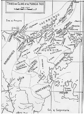
He described clans as ‘the largest units of solidarity’ and found them to be ‘exogamic patrilineal group[s] averaging forty or fifty individuals’.16 Subsequent investigations largely support this finding, though some of these more recent studies, as we shall see, have embellished Warner’s schema to reflect their own understandings and theoretical predilections. Warner noted too that of the ‘four cultural groups’ of north east Arnhem Land, the Murngin ‘have many more clans’ than the other groupings: in the course of his overview of Murngin society he mentioned some 37 of them. Warner was convinced that ‘ownership of the land’ was a ‘permanent and inextricable’ feature of Murngin culture, that such ownership was vested in the clan and that such ownership was by way of ‘immemorial tradition’.17 According to Warner, Murngin territory ranged from ‘Cape Wessel in the northeast’ to the ‘islands and the coast of the eastern side of the Gulf of Carpentaria to Blue Mud Bay’ and ‘eastward over to the upper waters of the Goyder and Glyde Rivers’.18 He attributed ownership of this region to many clans, which appear in the smaller type on the map below, while the names conveyed in larger type are those of the Murngin ‘tribes’. (See Fig. 1.2, but note that Boun, Ingura, Nakara, Nuncabuya and Rainbarngo are the names of neighbouring non-Murngin ‘tribes’.)
12 Warner 1958, p. 3.
13 Ibid., pp. 3-4.
14 Ibid., p. 15, especially notes 1 and 2.
15 Ibid., p. 30.
16 Ibid., p. 16.
17 Ibid., pp. 18-19.
18 Ibid., p. 36.
I include Warner’s map (Fig. 1.2) here not only because its makes an important reap-pearance in later events, but also because it serves as a reminder that his were the first attempts to chart Yolngu society and from it latter-day anthropologists have taken their bearings. Many of the clan names appearing on the map are now obscure, though a number have modern equivalents,19 but I am not in a position to comment on their sta-tus. There is, however, one oddity that arises from contemplation of Warner’s map: it does not conform with Warner’s description of Murngin territory. It is clear from view-ing the map that Warner has mistaken his east for his west: the Gulf of Carpentaria marks the eastern extremity of Murngin territory, while the Goyder and Glyde Rivers might be said to form the western bounds of that territory. No doubt this apparent loss of bearings is an aberration that is perhaps explained as a consequence of his writing the account in the northern hemisphere.
***
II
From the moment the Commonwealth government assumed control of the Northern Territory in 1911, the territory was viewed from the southern seat of power as a far-flung possession to be ruled by remote and, as we shall see, haphazard control. As Heatley noted, for the 25 years between 1911 and 1936, four different departments and 22 different ministers were responsible for the territory; on Porter’s count, there were ten different ministers for the years 1932 to 1951.20 These southern politicians and their bureaucrats had no real ambition to populate the country, even though they had a vague awareness that the vacant land might prove a useful first line of defence against northern marauders and that it might still somehow be used to turn a profit.21
Early attempts to develop industries — pastoral, agricultural and mining seemed the most promising — soon encountered problems of unreliable workforce, erratic seasons, hostile terrain and long distances between raw materials and eventual markets. The
19 Djapu remains unchanged; Kolpa is now Galpu; Darlongo is Dhalwangu; Mardepa is Madarrpa; Wangurri remains unchanged; Riraidjino is Rirratjingu; Komaits is likely to be Gu-matj; and Gwiyamil may be Ngyamil.
Fig. 1.3: The ‘spheres of influence’ of various denominations, Northern Territory, 1913
Fig. 1.4: Extent of the Arnhem Land Aboriginal Reserve, 1941 only workers who seemed willing or able to tolerate the conditions were ‘coloured’,
but these ‘Asiatics’ — as Baldwin Spencer, in his capacity as Special Commissioner and Chief Protector of Aborigines, noted in his report of 1913 — were liable to corrupt the Indigenous population by supplying alcohol and opium and by using Indigenous women as prostitutes. To Spencer’s mind the only way to avoid these moral panics (most notably, miscegenation) was to create reserves for the containment, protection and segregation of the Indigenous population. As Spencer saw it, ‘the care of the ab-originals of the Northern Territory should be made a national responsibility and any scheme for the purpose of preserving and uplifting them should be under the control of the Commonwealth Government’, rather than Christian or charitable missions, and the government should move quickly to establish reserves while the land was still unoccupied.22 By the time of Spencer’s report, the major Australian churches had an-nounced to the Commonwealth their preferred ‘spheres of influence’ over undesignat-ed lands in the territory and had undertaken to establish missions in those areas (see Fig. 1.3).23
Other than upholding the central tenet of the policy that came to be known as protec-tionism, the Commonwealth showed little initiative or took little action in the sphere of Aboriginal affairs until public outcry over a massacre in 1927 forced the government to appoint J.W. Bleakley (Queensland’s Chief Protector of Aborigines, 1913-1942) in May 1928 to conduct an inquiry into the living conditions of Aboriginal people in the North-ern Territory.24 Unlike Spencer, Bleakley advocated that the care of Aboriginal people was best ‘placed in the hands of subsidised mission organisations’, since ‘[t]he Govern-ment, with its tremendous task of developing the country, would be unwise to burden itself, and its already overtaxed machinery, with the worry of management of a num-ber of charitable institutions’.25 Bleakley recommended that missions, at least initially, confine themselves to the exercise of ‘benevolent supervision’: that is, winning the trust of ‘myalls’ (i.e. ‘full-bloods’) ‘by kindly ministrations, relieving them in distress or sickness and guarding them from abuse’, but, wherever possible, taking care ‘not to draw the people away unnecessarily from their tribal life’.26 He advised that a chain of missions along the coast of Arnhem Land was the best prospect for protecting Yolngu against unwanted intrusion and exploitation, but he foresaw this as only a temporary measure, since ‘[t]he native, once having come into contact with the white man or alien and acquired a taste for his foods and luxuries, is not likely to longer remain a content-ed savage’.27 Thus, he recommended that an Aboriginal reserve be created in Arnhem Land, and it was one of the few recommendations made by Bleakley that the Common-wealth, in the thick of the Great Depression, chose to implement.
More than 31,200 square miles (49,920 km2) was gazetted as the Arnhem Land
Aboriginal Reserve in April 1931, and in 1940, with the addition of a southern section,
22 CPP 45/1913, pp. 48, 51.
23 Frank Paton of the Presbyterian Church to Atlee Hunt, Secretary, Dept of External
Affairs, 20/12/1912. In the event the Presbyterian Church did not take up its area, which subse
-quently was held by the Methodist Church (NAA A659 1943/1/1376).
24 The massacre was at the Forrest River in Western Australia (Austin 1997, p. 121).
25 CPP 1929/12, pp. 24-5.
26 Ibid., p. 26.
the reserve expanded to 66,000 square miles (105,600 km2) (Fig.1.4). As Ronald and Catherine Berndt would later note, from ‘the natives’ point of view, the formation of the Reserve meant nothing at all’ since it was ‘their own territory, where their ancestors had lived and they were bound to it by strong spiritual ties’.28 To Bleakley there were few other contending purposes for the land: ‘the country is very poor, no one requires it, and those [pastoralists] who previously have taken some of it up have abandoned it’.29 By the time of the gazettal, a number of Christian missions were already operating in the region. The Methodist Missionary Society (later known as the Methodist
Overseas Mission or MOM) was running missions at Goulburn Island (established in 1916) and Milingimbi (1921); the Anglicans’ Church Missionary Society was operating at Roper River (1909), Emerald River (Groote Eylandt, 1921) and Oenpelli on the western edge of Arnhem Land in 1925. Missionaries, whatever their denomination, set about building their settlements with Indigenous labour, establishing routines of worship and discouraging traditional practices with varying degrees of zeal and success.
***
III
While Macassans had been prohibited from their long-standing practices of harvesting trepang (bêche de mer) in waters off the northern Australian coastline from 1907, illic-it visillic-its by Japanese trepangers and pearlers were becoming more numerous by the 1920s, and the Northern Territory Administration (NTA) called upon coastal missions to report any unusual movements or landings. Sporadic violence against the alien trepangers and pearlers helped give Arnhem Land a reputation as ‘the abode of ag-gressive Aborigines’,30 a reputation that was confirmed by the murder of five Japanese trepangers and three white men, including police constable A.S. McColl, in three sepa-rate events, which collectively became known as the ‘Caledon Bay incident’ of 1932-33. Newspapers in Darwin and in the populous south called for a punitive expedition to catch those responsible, but the Commonwealth government instead chose the offer of three Anglican missionaries to persuade the offenders to give themselves up. With the help of the white trepanger Fred Grey and the legendary Yolngu warrior Wonggu, the ‘peace mission’, as it became known, succeeded in rounding up the culprits — three of Wonggu’s sons (Natjiyalma, Maaw and Ngarkaya) who had killed the Japanese; Dhaki-yarr, who had killed McColl; and another man, Merarra — in March 1934 and in deliv-ering them to Darwin, where they languished in jail for four months before being tried by Judge Wells. Wonggu’s sons were sentenced to 20 years’ imprisonment; Merarra was released for lack of evidence; and Dhakiyarr was sentenced to death. In reviewing Dhakiyarr’s case on appeal, the High Court ordered his immediate release, but, upon release, he vanished without a trace, presumed murdered. The publicity and furore generated by the cases also led to calls for the immediate release of Wonggu’s sons.31 Donald Thomson — anthropologist, zoologist, journalist and adventurer — was duly given a commission ‘to go to Arnhem Land to establish friendly relations with the
28 Berndt & Berndt 1954, pp. 177-178.
29 CPP 1929/12, p. 34.
30 Ibid., p. 22.
31 Further details can be found in Egan 1996, Austin 1997, Dewar 1992, Thomson 2003.
people, to restore peace in the area, and to study and report on the problems of these people’.32 After lengthy negotiations with the federal government, he finally set out from Melbourne early in March 1935 — that is, some 15 months after the missionaries had succeeded in rounding up the Yolngu culprits. In Darwin at the end of May, Thom-son visited Wonggu’s three Thom-sons in Fanny Bay jail; they gave him ‘a message stick, accompanied by an oral message for their father, 500 miles away in Arnhem Land’.33 Thomson began his fieldwork in earnest in June 1935 and over the next six months, until he returned to Melbourne, he carried out five major expeditions ‘of more than 500 miles [800 kms] on foot and by canoe through the worst of the territory, in addition to journeys by sea amounting to 3,000 miles’ (4,800 kms). Once back in Melbourne, he was able to report that ‘not a single Aboriginal was killed in eastern Arnhem Land while I was in the area’ and he was confident that ‘the whole area was now under control’,34 but still he, like Bleakley, insisted that the ‘absolute segregation’ of Arnhem Land was essential for the continuation of peace and for the nomadic way of Yolngu life. He advised the Department of the Interior that Yolngu not be encouraged to congregate at missions or stations and advocated for regular patrols by officers who had some anthropological training. In his report he also called for ‘a settled, uniform, policy for the treatment of the whole of the Aboriginal population of Australia’ and for a national Department of Native Affairs to oversee this policy.35
Sometime before Thomson’s arrival, the superintendent of the Milingimbi mission, Theodor Webb, advocated a very different solution for the restoration of peace in eastern Arnhem Land: that another mission be established in the vicinity of Caledon Bay. Even though Thomson had tried to urge the federal government in October 1934 that ‘no approval be given for the initiation of fresh enterprises in Arnhem Land’ until he had completed his investigations,36 the NTA now approved the search for a suitable location for the new mission by Wilbur Chaseling, another MOM missionary. After surveying the coast as far as Caledon Bay, Chaseling pronounced Yirrkala the best site. Despite ‘an exposed anchorage and poor soil’, Yirrkala at least had ‘fresh water, an ele-vated site and clean beaches’.37 By mid-November 1935, sufficient timber had been cut and ferried from Milingimbi to construct a large shed at Yirrkala, and with this the mis-sion was declared opened. A 21-year lease of 175 square miles (280 km2) was eventually issued in July 1936 to MOM for its operations at Yirrkala. Chaseling moved quickly to establish a number of operating principles at the new mission, one being ‘no work, no pay’. Schebeck later recorded the way this was accomplished:
In 1966 I recorded from an old clan leader the story of the arrival of the mission-aries: these men came around, distributing flour, tea, sugar and tobacco. When the people started getting used to this treatment, the old man remembered laughingly,
32 Thomson 2003, p. 31.
33 Ibid., p. 37.
34 Ibid., p. 113. Here Thomson says ‘I received instructions to return south’, but a memo
of 6/2/1936 reads: ‘On 1 November 1935, the Minister indicated that he had agreed to a re-quest that Dr Thomson be allowed to come south for a spell during the wet season’ (NAA A659 1939/1/5250).
35 Thomson 1936, p. 46. Thomson submitted this report to the Minister for the Interior, Thomas Paterson, on 9/4/1936.
36 Thomson 1939, p. 15.
they thought this would go on like this for ever. But one day, the white people said: ‘Wait a moment, before I give you this, just do a little job for me’. Thus, the mission work started.38
Another principle was that the mission should be, as far as possible, ‘neutral terri-tory’.39 Chaseling also followed the example set by Webb at Milingimbi of tolerating Yolngu traditions while at the same time promoting Christianity and in encouraging the production of Yolngu arts and crafts to supplement the mission’s income. Chaseling would remain at Yirrkala for the first two years of World War 2.
Donald Thomson began his second tour of Arnhem Land by collecting Wonggu’s three sons from Fanny Bay jail and a few other Yolngu, who ‘were then derelict’ in Darwin’s Chinese quarter.40 They set sail from Darwin on 28 June 1936 and, after calling in at Goulburn Island and Milingimbi, eventually arrived at the new outpost of Yirrkala, where Wonggu happened to be visiting at the time.41 Having repatriated his charges, Thomson immediately set out to investigate widespread ‘tribal fighting’ that had been reported by the southern press to have erupted in ‘the area between Blue Mud Bay and Arnhem Bay’.42 Thomson concluded that ‘in almost every case [the trouble] originated among natives who have been much in contact with outside influence’.43
Thomson detected much greater activity by outsiders — particularly Japanese tre-pangers and pearlers — in the region since his previous visit. ‘Throughout 1937, the steadily growing number of Japanese-manned pearling vessels in the waters of the reserve was a most potent factor in the growing unrest that was becoming steadily more serious each month,’ he reported.44 In May he witnessed ‘upwards of 70 vessels’ operating around the Crocodile Islands (in the vicinity of Milingimbi) alone and from this calculated that perhaps as many as 700 Japanese were in the waters of Arnhem Land. The fleets had established ‘watering depots’ at various locations, and Yolngu ‘congregated at [these] various rendezvous to wait the return of the boats and the orgy that they grew to expect’. Women and girls were prostituted for food, clothing and tobacco; all too often the prostitution led to ‘serious friction’ or risked the danger of disease.45 To make matters worse, ‘the aborigines knew that all this was in defiance of the white man’s law’ and, in consequence, ‘the prestige of the white man fell greatly in their eyes’.46
In Thomson’s view ‘the highly complex organization of these people breaks down as soon as it comes in contact with outside influence’.47 The NTA had contributed to this situation, in his opinion, through its failure to regulate the issue of entry permits to the
38 Schebeck 1973, pp. 75-76. 39 Chaseling 1957, pp. 17, 22.
40 Thomson 1939, p. 3.
41 Chaseling reported that Thomson effectively ‘dumped’ the three prodigals on the
mission, causing unrest. ‘This greatly retarded our work as these boys regarded the episode as a joke in that they had been taken to Darwin where they had lived in luxury in gaol and were then returned home all because they had slaughtered some Japanese.’ Chaseling to Burton, 16/3/1938 (Elkin Papers, Box 97, 1/14/57).
42 Thomson 1939, p. 5.
43 Ibid., p. 14.
44 Ibid., p. 15.
45 Ibid., p. 15.
46 Ibid., p.15.
47 Ibid., p. 14.
Arnhem Land reserve (which he had suggested in October 1934) and through its failure to establish a presence in the region. Thomson recommended that the reserve be ren-dered ‘inviolable’ so that its residents were ‘absolutely segregated … to preserve intact their social organization, their social and political institutions, and their culture in its entirety’.48 Thomson was not, however, advocating ‘a permanent segregation for all time’, but thought his recommendations should suffice until ‘a sound working policy and one in the best interests of the aboriginals is established, tested, and proved by experience over a long period’.49
It is clear from Thomson’s various writings about his second tour that this aspect of his investigation caused him considerable distress, though he derived great satisfaction, if not outright pleasure, from other facets of his work. His official reports and other writ-ings from this second and longer expedition are peppered with references to his anthro-pological investigations and to his other endeavours. On the anthroanthro-pological side, he had ascertained ‘the names of the areas occupied by the various tribes and local groups’; he had studied Yolngu social and kinship organisation; investigated their legal and moral codes; and inquired into the ‘magical beliefs and practices which play a large part in the regulation of native conduct’.50 He also studied fishing techniques and canoe construc-tion, though the highlight of this trip was witnessing the goose-egg gathering in the Arafura Swamp, now immortalised in the film, Ten Canoes.51 He promised the Common-wealth a full and separate anthropological report, which he would write while visiting Cambridge University the following year and for which he received payment in advance. Unfortunately, it was a promise Thomson failed to keep. Nicolas Peterson suggests that the publication of Warner’s A Black Civilization at about this time ‘pre-empted’ much of what Thomson intended writing and so he abandoned the project.52
Through family connections Thomson managed to have an amphibian aircraft from the RAAF put at his disposal over a three-week period, enabling him to undertake ‘a number of extended reconnaissance flights’.53 Later he would write that the region from the air ‘presents a barren, desolate, almost forbidding appearance, though it is by no means the inhospitable territory of the popular imagination’.54 His more immediate interest, however, was in trying to settle the location of various rivers in north-east Arnhem Land, though, as Peterson notes, some confusion persisted in various maps (including Thomson’s) until the 1950s.55
48 Thomson 1938, p. 5 (recommendations 1 & 2). 49 Ibid., p. 7.
50 Thomson 1939, p. 6.
51 Ten Canoes is ‘a film by Rolf de Heer and the people of Ramingining’, produced in 2006
by Palace Films and Madman Films.
52 Peterson 2003, p. 20. He did publish accounts of the egg hunt and fishing techniques in
the journal, Man, in 1938 and 1939. He had given basic accounts of social organisation and kin-ship in his two reports (Thomson 1936, 1939). As late as 1954, the Minister for Territories, Paul Hasluck, was still trying to get the anthropological report out of him; it was cited as a reason for not providing funding to Thomson, though no one in the department had explained this reason to Thomson (NAA A462 743/7).
53 Thomson 1939, p. 10. Peterson (2003, p. 12) notes that Thomson’s brother-in-law was secretary in the Department of the Air.
54 Thomson 1949, p. 37.