De
evelopm
Sy
U
Fa
ment and
ystem f
Cours
Bac
University
aculty of E
d Evalua
for Con
A dis
Fi
In fulfilm
se ENG41
To
chelor of
Sub
y of South
Engineer
ation of
dition A
ssertation
iona Jane
ment of the
11 & ENG
owards the
f Enginee
bmitted: Oc
hern Que
ring and S
f a Field
Assessm
submitted
e Nielson
requireme
G4112 Res
e degree of
ering (Ag
ctober, 201
eensland
Surveying
d Mobili
ment of
by
n
ents of
earch Pro
f
gricultura
12
g
ity Data
f Assets
oject
al)
a Captur
s
ABSTRACT
The principle aim of the research was to determine if a mobile data capture system
could be suitably applied to the condition assessment of assets within SunWater.
The study involved research into the current condition assessment process within the
Irrigation & Drainage department of SunWater. Assets considered in this project
involved those specific to the Barratta Section of the Burdekin Haughton Water Supply
Scheme (BHWSS). This research involved the engineers and technical officers of the
Asset Management, Irrigation & Drainage department within SunWater.
Established during this research was the current condition assessment process,
possible mobile data capture solutions to this process and a trial of a mobile data
capture system within the Barratta Section of the BHWSS. The associated costs of the
current process and mobile solutions were then analysed making use of the outcomes
of the trial. From this analysis, conclusions were able to be drawn as to the relative
merits of mobile data capture systems and their usefulness to SunWater.
The physical output of the research included a trial application for the completion of
asset condition assessments and a recommendation on the economic viability for
implementing a mobile data capture system within SunWater.
The results of this study will help to determine if SunWater can incorporate mobile data
capture systems into its condition assessment processes and thereby support its
DISSERTATION
DEVELOPMENT AND EVALUATION OF A FIELD MOBILITY DATA CAPTURE SYSTEM FOR CONDITION ASSESSMENT OF ASSETS
USQ Dissertation
Fiona Nielson May 2013
0050041245 Commercial In Confidence Page ii
University of Southern Queensland
Faculty of Health, Engineering and Sciences
ENG4111/ENG4112 Research Project
Limitations of Use
The Council of the University of Southern Queensland, its Faculty of Health,
Engineering & Sciences, and the staff of the University of Southern Queensland, do not
accept any responsibility for the truth, accuracy or completeness of material contained
within or associated with this dissertation.
Persons using all or any part of this material do so at their own risk, and not at the risk
of the Council of the University of Southern Queensland, its Faculty of Health,
Engineering & Sciences or the staff of the University of Southern Queensland.
This dissertation reports an educational exercise and has no purpose or validity beyond
this exercise. The sole purpose of the course pair entitled “Research Project” is to
contribute to the overall education within the student’s chosen degree program. This
document, the associated hardware, software, drawings, and other material set out in
the associated appendices should not be used for any other purpose: if they are so
CERTIFICATION OF DISSERTATION
I certify that the ideas, designs and experimental work, results, analyses and
conclusions set out in this dissertation are entirely my own effort, except where
otherwise indicated and acknowledged.
I further certify that the work is original and has not been previously submitted for
assessment in any other course or institution, except where specifically stated.
Fiona Jane Nielson
0050041245
________________________ Signature
DISSERTATION
DEVELOPMENT AND EVALUATION OF A FIELD MOBILITY DATA CAPTURE SYSTEM FOR CONDITION ASSESSMENT OF ASSETS
USQ Dissertation
Fiona Nielson May 2013
0050041245 Commercial In Confidence Page iv
ACKNOWLEDGEMENTS
This research was carried out under the principal supervision of Dr Alexander Kist of the
University of Southern Queensland and Mr Peter Marshall of SunWater. Thanks and
appreciation is extended to both for their help and understanding during this project.
Appreciation is also due to the staff of the Irrigation and Drainage department of
SunWater for their help and support during the research, trial and final stages of this
project.
Finally I would like to thank my partner Heath and my son Hugh for their patience and
TABLE OF CONTENTS
ABSTRACT ... I
CERTIFICATION OF DISSERTATION ... III
ACKNOWLEDGEMENTS ...IV
LIST OF FIGURES ...VII
LIST OF TABLES ... VIII
LIST OF APPENDICES ... VIII
ABBREVIATIONS ...IX
1.0 INTRODUCTION ... 1
1.1 OUTLINE OF THE STUDY ... 1
1.2 INTRODUCTION ... 1
1.2.1 SunWater Ltd ... 1
1.2.2 Asset Management ... 3
1.2.3 Condition Assessment ... 3
1.3 THE PROBLEM ... 3
1.4 RESEARCH OBJECTIVES ... 5
1.5 SUMMARY ... 7
2.0 BACKGROUND INFORMATION ... 8
2.1 RESOURCE PLANNING ... 8
2.2 THE CONDITION ASSESSMENT PROCESS ... 8
2.2.1 Select Location ... 9
2.2.2 Evaluate Assets ... 9
2.2.3 Print Scheme Maps and Condition Assessment Forms ... 10
2.2.4 Upload Locations to Handheld GPS ... 12
2.2.5 Field Condition Assessment ... 12
2.2.6 Upload of Condition Assessment ... 13
2.3 WHAT DOES SUNWATER REQUIRE ... 15
2.3.1 Requirements Analysis ... 15
2.3.2 Hardware Ranking ... 16
2.3.3 Software Ranking ... 20
3.0 CONDITION ASSESSMENT AND DATA CAPTURE ... 22
3.1 MANUAL CONDITION ASSESSMENT AND DATA CAPTURE ... 22
3.2 MOBILE CONDITION ASSESSMENT AND DATA CAPTURE ... 23
DISSERTATION
DEVELOPMENT AND EVALUATION OF A FIELD MOBILITY DATA CAPTURE SYSTEM FOR CONDITION ASSESSMENT OF ASSETS
USQ Dissertation
Fiona Nielson May 2013
0050041245 Commercial In Confidence Page vi
3.2.2 The Software ... 29
3.3 ASSET MANAGEMENT ... 32
3.4 SUMMARY ... 33
4.0 DEVELOPING THE MOBILE DATA CAPTURE TRIAL SYSTEM ... 34
4.1 THE DEVICE ... 34
4.2 THE SOFTWARE ... 35
4.3 DATA DEVELOPMENT AND QUALITY CONTROL ... 36
4.4 ARCMAP – SETTING DOMAINS AND SUBTYPES ... 38
4.5 THE COLLECTOR APP ... 39
4.6 CUSTOMISATION ... 40
4.7 THE TRIAL ... 41
4.7.1 PREPARATION ... 42
4.7.2 CONDITION ASSESSMENT ... 43
4.7.3 POST PROCESSING ... 43
4.8 COSTING OF EXISTING PROCESSES ... 43
5.0 RESULTS AND RECOMMENDATIONS ... 45
5.1 QUANTITATIVE RESULTS ... 45
5.2 DEVICE PERFORMANCE TRIAL RESULTS ... 48
5.3 SOFTWARE PERFORMANCE TRIAL RESULTS ... 49
5.4 HARDWARE RANKING RESULTS ... 50
5.5 SOFTWARE RANKING RESULTS ... 51
6.0 CONCLUSIONS ... 53
6.1 INTRODUCTION ... 53
6.2 CONSEQUENTIAL EFFECTS ... 53
6.3 CONCLUSIONS ... 54
6.3.1 Is Mobile Data Capture a Possibility? ... 54
6.3.2 Is the Prototype System Acceptable? ... 55
6.4 FURTHER WORK ... 55
LIST OF FIGURES
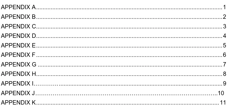
Figure 1.1 - SunWater Operations and Infrastructure (SunWater 2012) ... 2
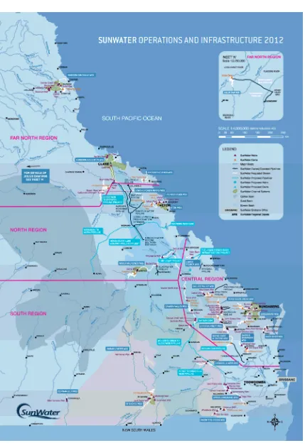
Figure 1.2 - Asset Management Organisational Hierarchy (SunWater 2013) ... 5
Figure 2.1 - Manual Condition Assessment Process ... 9
Figure 2.2 - Example Condition Assessment Form from SAP (SunWater 2013) ... 11
Figure 2.3 - Criteria Scoring Number Line ... 17
Figure 3.1 - Top 8 Mobile Operating Systems in Australia from Feb 2012 - Feb 2013 (Source StatCounter Global Stats) ... 24
Figure 3.2 - Apple iPhone 5 Smartphone (Apple 2013) ... 25
Figure 3.3 - Samsung Galaxy S4 Smartphone (Samsung 2013) ... 25
Figure 3.4 - Apple iPad Tablet (Apple 2013) ... 26
Figure 3.5 - Microsoft Surface Tablet (Microsoft 2013) ... 26
Figure 3.6 - Samsung Galaxy Note Tablet (Samsung 2013) ... 26
Figure 3.7 - Trimble Yuma Rugged Tablet (Trimble 2013) ... 27
Figure 3.8 - Motorola MC67 Mobile Computer (Motorola Solutions 2013) ... 27
Figure 3.9 - Dell Inspiron 17 Laptop (Dell 2013) ... 28
Figure 3.10 - Panasonic Toughbook Rugged Laptop (Toughbook 2013) ... 28
Figure 3.11 - Telstra Network Coverage in Queensland (Telstra 2013) ... 31
Figure 4.1 - Customised Pop-Up Window in Collector App ... 41
Figure 4.2 - The Mobile Data Capture Process ... 42
Figure 5.1 – Percentage Task Distribution ... 45
DISSERTATION
DEVELOPMENT AND EVALUATION OF A FIELD MOBILITY DATA CAPTURE SYSTEM FOR CONDITION ASSESSMENT OF ASSETS
USQ Dissertation
Fiona Nielson May 2013
0050041245 Commercial In Confidence Page viii
LIST OF TABLES
Table 2.1 - Condition Assessment Cost Breakdown per Scheme ... 14
Table 2.2 - Hardware Criteria Breakdown and Scoring ... 19
Table 2.3 - Software Criteria Breakdown and Scoring ... 21
Table 5.1 - Percentage Breakdown of Condition Assessment Tasks ... 46
[image:9.595.83.556.341.561.2]Table 5.2 - Hardware Ranking Results ... 50
Table 5.3 - Software Ranking Results ... 51
LIST OF APPENDICES
APPENDIX A ... 1APPENDIX B ... 2
APPENDIX C ... 3
APPENDIX D ... 4
APPENDIX E ... 5
APPENDIX F ... 6
APPENDIX G ... 7
APPENDIX H ... 8
APPENDIX I…………. ... 9
APPENDIX J ………..10
ABBREVIATIONS
The following abbreviations have been used throughout the text:
BHWSS - Burdekin Haughton Water Supply Scheme
GOC - Government Owned Corporation
GIS - Geographical Information System
SAP - Systems, Applications and Products
ESRI - Environmental Systems Research Institute
ARMS - Asset Register and Management System
OS - Operating System
DISSERTATION
DEVELOPMENT AND EVALUATION OF A FIELD MOBILITY DATA CAPTURE SYSTEM FOR CONDITION ASSESSMENT OF ASSETS
USQ Dissertation
Fiona Nielson May 2013
0050041245 Commercial In Confidence Page 1
1.0 INTRODUCTION
1.1 OUTLINE OF THE STUDY
This study investigates the development and evaluation of a field mobility data capture
system for condition assessment of assets within the water industry. It looks at the
current condition assessment process and how this can be improved through the use of
mobile data capture systems. This includes investigation into types of mobile devices
and software platforms.
The main focus of the study is to develop and trial a mobile data capture system in the
BHWSS to determine the benefits, of implementing such a system. The purpose of the
study is to report on the outcomes of the trial, and analyse the results to provide a
recommendation to pursue or otherwise mobile data capture of asset condition within
SunWater.
1.2 INTRODUCTION
1.2.1 SunWater Ltd
SunWater Ltd is a Queensland based Government-Owned Corporation (GOC) which
was formed in 2001. SunWater’s extensive network of water supply infrastructure
supports mining, power generation, industry, urban development and irrigated
agriculture throughout Queensland (SunWater 2013).
SunWater owns and manages around $7 billion in water infrastructure assets and
supplies approximately 40% of all water used commercially in Queensland (SunWater
2013).
SunWater has an extensive infrastructure base including (SunWater 2012):
19 dams, 68 weirs and barrages, 85 major pumping stations and over 2500km of open
DISSERTATION
DEVELOPMENT AND EVALUATION OF A FIELD MOBILITY DATA CAPTURE SYSTEM FOR CONDITION ASSESSMENT OF ASSETS
USQ Dissertation
Fiona Nielson May 2013
0050041245 Commercial In Confidence Page 3
1.2.2 Asset Management
The extensive array of infrastructure present under SunWater ownership requires
thorough asset management. SunWater’s aim is “To manage our assets in a
sustainable manner to meet SunWater’s business objectives of safeguarding asset
integrity and ensuring asset serviceability.” (Asset Management Policy AM01_P1 2013).
In order to achieve this SunWater must carry out certain tasks, one of which is
performing condition assessments of all assets and recording these assessments in
SunWater’s corporate system.
1.2.3 Condition Assessment
Condition Assessment is the process by which an asset’s condition is objectively
reviewed against a defined criteria set and the results recorded for later review and
analysis. In the SunWater’s case, the data is stored within an SAP database.
Its purpose is ‘to establish a consistent, informed and auditable process for prioritising
expenditure on asset refurbishment based on the assessment and management of
asset condition.’ (Asset Refurbishment Planning: Methodology for Condition
Assessments of Assets 2012).
1.3 THE PROBLEM
Since the development of the first irrigation areas in the 1950’s, SunWater’s
infrastructure base has continued to expand through growth in the agriculture sector,
but also more recently the boom in the Queensland mining/industrial sector. As a result,
extensive pipeline and pump station assets have been added to the asset portfolio.
In 2000 SunWater upgraded its Asset Register and Management System (ARMS) to
SAP PM (Systems, Applications and Products Plant Maintenance). With the
implementation of this new management system, it was decided that a whole of
SunWater asset condition assessment would be necessary to ensure the asset data in
SunWater require condition assessments every 10 to 15 years. This means that these
assets will now be due for assessment or will be nearing assessment in 2015. Due to
this large number of assets, a more economical solution could provide significant cost
benefits over the earlier efforts.
In order to uphold the required standard of asset management across such a broad
asset base, it is important that alternative methods of data collection are investigated
and thereby allow SunWater to achieve a productivity improvement (‘Smarter, Lighter,
Faster’).
At present, the condition assessment process is distributed between sub-departments
of the Asset Management Group (Figure 1.2). The group is broken down into asset
specific departments, these being:
Dam Safety – Ensure that SunWater complies with the necessary regulatory
requirements.
Asset Information Policy and Standards – Develop and maintain the Asset Management
Policy and Standards framework and ensure compliance across all groups.
Pumps and Pipelines – Manage the pump stations and pipeline assets (i.e. Industrial
pipelines and all pumpstations)
Irrigation and Drainage – Manage the irrigation and drainage assets (i.e. Channels and
associated infrastructure)
Headworks – Manage the water storage assets (i.e. Dams and weirs)
The last three asset groups are all required to perform condition assessments of their
DISSERTATION
DEVELOPMENT AND EVALUATION OF A FIELD MOBILITY DATA CAPTURE SYSTEM FOR CONDITION ASSESSMENT OF ASSETS
USQ Dissertation
Fiona Nielson May 2013
0050041245 Commercial In Confidence Page 5
processes utilised by the Irrigation and Drainage group. It is expected that the
outcomes of this report will be considered by SunWater as part of its continual
[image:15.595.85.560.200.414.2]improvement initiatives.
Figure 1.2 - Asset Management Organisational Hierarchy (SunWater 2013)
The current condition assessment methods that are employed by SunWater are eligible
for efficiency improvements and are the catalyst for this thesis as discussed in Section
0.
1.4 RESEARCH OBJECTIVES
The principle aim of this research is to develop and trial an application that will enable
electronic recording of asset condition assessments in the field. This trial will aid in
determining whether there are benefits in advancing with such a system within
SunWater.
There are nine objectives associated with this aim (as per the specification, APPENDIX
A):
Manager Asset Management Principal Engineer,
Dam Safety Senior Technical
Officer
(A) Principal Engineer, Asset Information Policy &
Standards
Systems Administrator
Senior Project Manager Systems Administrator Systems Administrator Systems
Coordinator Technical Officer
Senior Engineer, Pumps and Pipelines Electrical Engineer Engineer
(Graduate Program) Senior Technical
Officer (Civil)
Senior Technical Officer (Civil) Technical Officer
(Mechanical)
Engineer (Graduate Program)
Senior Mechanical Engineer
Senior Electrical Engineer
Engineer (Graduate Program)
Senior Engineer, Irrigation & Drainage Engineer Engineer
Technical Officer
(Mechanical) Senior Engineer Engineer Technical Officer
(Civil)
Engineer
Senior Engineer, Headworks
Senior Technical Officer
Senior Technical Officer
Asset Engineer Engineer
Senior Engineer Engineer
Senior Technical Officer
1) Undertake a basic requirements analysis, identify use cases and develop a
platform functional specification:
2) Undertake a comprehensive literature review covering but not limited to the
following aspects:
The range of commercially available field mobility solutions:
Industry user types, market requirements and directions;
Types of software available, trends and support prospects;
Types of hardware (i.e. tablet, phone. other), functionality and design
obsolescence; and
Advantages/Disadvantages of software/hardware/field data capture packages.
3) Develop an optimised prototype system incorporating a software
solution/hardware package that satisfies SunWater’s functional requirements.
Engage the services of a third party to develop software/hardware solutions as
required.
4) Develop and implement a test plan for developed software and hardware
component. Undertake field trials and review performance against functional
requirements;
5) Prepare an academic dissertation of the research project;
As time permits
6) Analyse and evaluate business processes in relation to the developed system.
7) Undertake cost/benefit analysis of implementing the field mobility solution in the
DISSERTATION
DEVELOPMENT AND EVALUATION OF A FIELD MOBILITY DATA CAPTURE SYSTEM FOR CONDITION ASSESSMENT OF ASSETS
USQ Dissertation
Fiona Nielson May 2013
0050041245 Commercial In Confidence Page 7
8) Subject to positive outcome of point 7), prepare a draft business case for the
Implementation of the system within SunWater asset management; and
9) Provide recommendations on the implementation of the system and the final
functional and technical specifications.
By meeting each of these objectives a suitable outcome can be reached to enable
SunWater to make an informed decision on the use of mobile data capture systems to
aid or replace current manual processes.
A timeline was also produced for this research project with appropriate target dates to
aid in successful completion of the above objectives. This can be seen in APPENDIX
K.
1.5 SUMMARY
SunWater’s business of operating and maintaining assets requires effective and
efficient processes and procedures. An element of these processes and procedures
involves the condition assessment of assets. This process helps to document valuable
asset information however can be at a considerable financial and resource cost to
SunWater.
To date SunWater has utilised only small components of mobile data capture within the
organisation without a huge emphasis on progressing in this area. It is therefore the
aim of this study to develop and trial one of these systems to determine if this is an area
2.0 BACKGROUND
INFORMATION
2.1 RESOURCE PLANNING
The successful completion of this project will require a number of resources. For the
purposes of this project it has been decided to utilise hardware and software that is
already available within SunWater in order to complete the trial.
The hardware that will be utilised is a personal apple iPad tablet. This device was
manufactured in 2011 and is suitable to the outdoor conditions that will be faced during
the field condition assessments. This device is currently accessible and will be available
for the duration of the study.
SunWater utilises ESRI’s GIS packages which include ArcMap and GIS Server
packages. This also includes the licensing for ArcGIS Online and the Collector App
which is the software that will be utilised for the trial. As the iPad is iOS based the two
complement each other and will be suitable for the trial.
As an employee of SunWater since 2005 I have had extensive exposure to ESRI’s GIS
systems and will be capable of creating maps and mapping interfaces suitable for
condition assessment of assets within the BHWSS. Due to my current role as technical
officer I have access to the appropriate licences and computer to complete the required
tasks.
The trial data capture system will be utilising hardware and software that is already
available to SunWater so the study will not be imposing any extra costs to SunWater.
2.2 THE CONDITION ASSESSMENT PROCESS
As mentioned previously (Section 1.3) this study will be analysing the condition
assessment process adopted by the Asset Management, Irrigation & Drainage Group.
Figure 2.1 and subsequent sections show and explain the processes which are
DISSE DEVE SYST USQ Fiona 00500 Figur 2.2.1 The Irriga com thes asse 2.2.2 Once asse days them
1 – H
ERTATION ELOPMENT A TEM FOR CON
Nielson 041245 re 2.1 - Manua
1 Select
first step
ation & Dra
pletes con
e assessm
essments (
2 Evalua
e the sche
ets need to
s with the
m on a num
Has the as
AND EVALUAT NDITION ASS
al Condition A
t Location
in carrying
ainage Gro
ndition ass
ments is d
(i.e. flood e
ate Assets
eme is sel
o be asse
aim of ass
mber of crit
sset ever b
TION OF A FIE SESSMENT O
C Assessment
n
g out a con
oup servic
sessments
dependent
events).
s
ected an e
ssed. Typ
sessing 50 eria: een asses ELD MOBILIT OF ASSETS Dissert Commercial In Process ndition ass
es all wate
in each s
t upon shu
evaluation
pically field
0 assets pe
ssed.
TY DATA CAP
tation
n Confidence
sessment i
er supply s
scheme ye
utdowns,
process i
d condition
er day. Th
PTURE
s to determ
schemes w
arly. The
staff availa
s carried o
n assessm
he assets a
mine the lo
within SunW
location a
ability and
out to dete
ments will l
are selecte
May 2 Pag
ocation. T
Water and
and timing
d emergen
ermine wh
last for thr
ed by sort
[image:19.595.89.542.115.404.2]2 – Is the asset due to be assessed.
3 – Has an assessment been requested.
Our corporate data system enables us to sort on these criteria and select a suitable
range of assets to assess.
2.2.3 Print Scheme Maps and Condition Assessment Forms
Condition Assessment Forms for each asset are then printed, hole punched and placed
DISSERTATION
DEVELOPMENT AND EVALUATION OF A FIELD MOBILITY DATA CAPTURE SYSTEM FOR CONDITION ASSESSMENT OF ASSETS
USQ Dissertation
Fiona Nielson May 2013
[image:21.595.113.528.102.729.2]0050041245 Commercial In Confidence Page 11
The next step is to locate the relevant scheme maps and if necessary update to include
selected assets and print (APPENDIX B).
2.2.4 Upload Locations to Handheld GPS
The assets also need to be uploaded to handheld GPS to enable easier location in the
field. The GPS must be cleared of all existing data and new data uploaded. This
process can take a considerable amount of time due to the inconsistencies between our
corporate GIS system and our corporate data system. Any assets that aren’t currently
included in SunWater’s GIS system are located using tools within ArcMap and added to
the GPS.
2.2.5 Field Condition Assessment
Once the above processes are complete staff are able to travel to site to assess each
asset. This involves:
Location of specific asset utilising A3 scheme maps (APPENDIX B) and handheld GPS.
This form of navigation requires more than one person and so all condition
assessments are completed with two staff members. This is also a safety precaution
due to the remote locations of some assets.
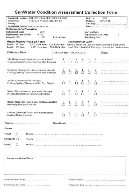
Once the asset is located the condition assessment on the asset is carried out by
manually filling out the condition assessment forms on site (Figure 2.2). Each criteria
on the condition assessment form is given a rating from 1 to 6. These criteria and
examples of ratings are provided in the ‘Condition Assessment of Civil Assets’ manual
which is to be referred to before making an assessment. Refer to APPENDIX H for an
example excerpt from this manual.
A photo of the asset is then taken with a handheld camera and the photo number
recorded on the condition assessment form. A GPS location is also taken with a
handheld GPS and the waypoint recorded on the condition assessment form. This
DISSERTATION
DEVELOPMENT AND EVALUATION OF A FIELD MOBILITY DATA CAPTURE SYSTEM FOR CONDITION ASSESSMENT OF ASSETS
USQ Dissertation
Fiona Nielson May 2013
0050041245 Commercial In Confidence Page 13
2.2.6 Upload of Condition Assessment
Once back in the office the condition assessments must be recorded on our corporate
systems. This is a considerable process and must be completed manually.
To begin with, each of the condition assessment forms need to be manually transcribed
into a pre-formatted spreadsheet (APPENDIX C). This process must be carried out for
all 150 assets.
The next process is to rename each photo (150 photos or more) with the asset’s
specific object number and description. The object number is a unique identification
number that helps to identify an asset.
Finally the GPS locations of each asset are uploaded and manually renamed for
inclusion in our corporate GIS system.
Once complete the result is an asset that is linked to an up to date condition
assessment with photo and accurate GPS location.
The entire process is a manual one with transcription of data occurring numerous times.
This double handling and intense manual interaction leaves room for human error and
results in a time consuming process.
It’s worth noting that the entire process is carried out by technical officers and engineers
with no assistance from administration resulting in quite a costly procedure for
SunWater.
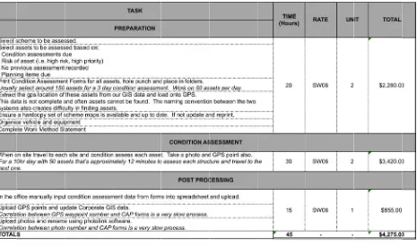
A tabulated breakdown of the processes involved and the time to complete these
Table This Drai sche 2012 sche asse It is asse once Sect
e 2.1 - Conditi
financial
nage wou
emes per
2/2013 co
emes per y
essed this
predicted t
essments w
e a compl
tion 4.0.
ion Assessm
breakdow
uld be spe
year. Wh
ondition as
year (APP
equates to
that the im
would resu
ete trial h
ent Cost Bre
wn is for o
ending a w
hen inclus
ssessment
ENDIX D)
o approxim
plementat
ult in consid
has been c
eakdown per S
one water
week long
sion of tr
ts estimat
). When y
mately $109
ion of a mo
derable sa
carried ou
Scheme
r supply s
condition
avel costs
tes this fi
you extrapo
9.00 per as
obile devic
avings for S
ut following
scheme. T
n assessm
s is cons
gure to b
olate this d
sset.
ce for recor
SunWater.
g the meth
Typically Ir
ment at se
sidered da
be $90,00
data acros
rding of the
This will
hodology
rrigation a
ven differe
ata from t
0 for sev
ss the asse
[image:24.595.89.554.153.428.2]DISSERTATION
DEVELOPMENT AND EVALUATION OF A FIELD MOBILITY DATA CAPTURE SYSTEM FOR CONDITION ASSESSMENT OF ASSETS
USQ Dissertation
Fiona Nielson May 2013
0050041245 Commercial In Confidence Page 15
2.3 WHAT DOES SUNWATER REQUIRE
As previously mentioned the purpose of this thesis is to investigate improvements of the
above described condition assessment process through the implementation of a mobile
data capture system. In order to do this it is imperative that SunWater’s requirements
are considered in a bid to enable productive investigation.
2.3.1 Requirements Analysis
The successful implementation and uptake of this system requires examination of the
needs of not only SunWater but also the end user.
The first point to consider is the type of device and software that would be most suitable
for the process.
The device will be used outdoors in dusty and wet environments with the possibility of
drops onto hard surfaces so it’s evident that some form of rugged device is necessary.
It also needs to be visible in the sun and hence requires some form of anti-glare
measure.
In terms of software SunWater currently utilises SAP for its asset data information and
ESRI’s ArcMap for capture and storage of geospatial information. It would be ideal to
have a software package that incorporated both of these systems so there was a
seamless update of data across the board.
The user interface needs to appeal to the end user but also needs to easily perform its
function of recording condition assessments and associated capture such as
photographs and GPS locations. It is essential that all three of these actions are
included in the one system to ensure efficiency improvements.
Section 3.2.1 provides a breakdown of points for consideration before implementation of
such a system. These points will be considered throughout the investigation in a bid to
produce a fit for purpose system for SunWater. In short these points suggest the
that no data loss occurs through device failure etc, ensure that the software is platform
independent and can work on any operating system and that overall the system is better
than pen and paper.
The system needs to be more efficient than the current process however these
efficiencies need to positively outweigh any costs associated with the implementation
and support of the proposed system.
SunWater’s budget will be the final deciding factor on many of these points. For the
purposes of the trial system a personal mobile device and pre-existing software will be
utilised.
APPENDIX E and APPENDIX F show a matrix of the criteria that the hardware and
software solutions were rated against. In order to make an information decision about
which software and hardware is suitable these criteria have been given a rating system
that will provide an overall scoring for each hardware and software solution effectively
ranking them and providing a clear picture of which solutions are most beneficial for
SunWater.
2.3.2 Hardware Ranking
When investigating the hardware solutions available for SunWater the following criteria
were specified:
Rugged Enclosure Required; Operating System; Water Resistant; Multipurpose; Shock
Resistant; Gorilla Glass; Touchscreen/Stylus; Screen Size; Sunlight Visibility; Ingress
Protection (IP) Rating; GPS; Camera; Megapixels; Battery Life; Network; Storage Size;
Cost per Unit.
Each of these criteria were relevant to SunWater requirements however there are
certain criteria which are more desirable than others and these were ranked
accordingly. The ranking was established so that each criteria was related to a score
and these scores could then be accrued to establish a final score or ranking for
DISSE DEVE SYST USQ Fiona 00500 crite of 1 Figu Figur A br in ERTATION ELOPMENT A TEM FOR CON
Nielson 041245
ria outcom
or more. R
ure 2.3 below
4
No
re 2.3 - Criteri
reakdown
AND EVALUAT NDITION ASS
mes resultin
Refer
w for a visu
-3
ot Beneficia
ia Scoring Nu
and explan
TION OF A FIE SESSMENT O
C
ng in negat
ual represe
-2
al
umber Line
nation of e
ELD MOBILIT OF ASSETS Dissert Commercial In tive values entation of -1 0 Ne each criteria
TY DATA CAP
tation
n Confidence
s and posit
f this scorin
1
utral
a along wit
PTURE ive outcom ng metric. 2 B
th its scori
mes resultin
3
Beneficial
ng metric c
May 2 Page
ng in a sco
4
can be see
013 e 17
ore
Table 2.2.
Final outcomes for each of the hardware devices researched and their final ranking
DISSERTATION
DEVELOPMENT AND EVALUATION OF A FIELD MOBILITY DATA CAPTURE SYSTEM FOR CONDITION ASSESSMENT OF ASSETS
USQ Dissertation
Fiona Nielson May 2013
0050041245 Commercial In Confidence Page 19
Table 2.2 - Hardware Criteria Breakdown and Scoring
Criteria Explanation SunWater's Preference Outcome Score
Rugged Enclosure Required
Is a separate rugged enclosure required or does the device already encompass a built-in ruggedised eclosure as part of the device?
This criteria would depend on the cost of the enclosure. SunWater does require some form of enclosure if none is supplied with the device. It is however not necessarily more beneficial for this enclosure to be built into the hardware as this often leads to a more expensive outcome overall.
Yes No
0 1
Enclosure/Cost ($)
If the device does require a separate enclosure what is the cost of this?
Research of current adequate enclosures shows a price range of approximately $80 to $150.
Cost < $100 $100 < Cost < $200 Cost > $200
2 1 -1
Operating System What operating system does the device use?
This criteria has no real bearing on the outcome of the hardware. If a software decision was made and that software could only support certain operating systems then this criteria would have a large bearing on the hardware selection.
Operating System N/A
Water Resistant Is the device water resistant?
SunWater requires field hardware to be water resistant and this may be through either the use of an enclosure or the actual device may be resistant. Yes No 1 -1 Multipurpose
Can the device be used for functions other than just field data collection?
It's beneficial for SunWater to have a device that can be used for other business functions as well as for condition assessments. Condition assessments consume approximately 20% of the year for Irrigation and Drainage its therefore beneficial for SunWater is this device can be utilised in other business areas.
Yes No
2 -1
Shock Resistant Is the device shock resistant?
As this hardware will be used in the field it needs to be shock resistant and this may be through either the use of an enclosure or the actual device may be resistant to shock.
Yes No
2 -1
Toughened Glass
Does the device have a form of toughened glass either built in to the device or in the device enclosure?
It would be desireable to have a device that had some form of toughened glass as this would provide protection from cracking and perhaps device failure.
Yes No
1 0
Touchsreen/Stylus Does the device offer the use of a touchscreen/stylus or both?
This depends on the end user and the size of the device. If the device is large enough that touchscreen is easily utilised then this would be the preference. It would be beneficial however if the device supported both options to allow the user the choice. Trials with stylus devices currently owned by SunWater have proven to be awkward and not ideal in the field.
Touchscreen Stylus Both 1 0 2 Screen Size (inch)
Is the screen of the device of adequate size?
It would be desirable for the screen size of the device to be at least 7 inch
however smaller screens could be acceptable. Size < 7 inch
Size > 7 inch
0 1
High Visibility in Sunlight
Does the device have adequate visibility in sunlight to enable uninhibited use outdoors?
This is a requirement for SunWater as all condition assessments will be carried out in the field. There are ways to avoid this issue however high visibility will be scored as a benefit it it's available.
Yes No 2 -1 Ingress Protection Rating
Does the device have a suitable IP rating?
For the purposes of use within SunWater field operations it would be beneficial if the device had an IP rating of at least 65.
Yes No
1 -1
GPS Does the device have an adequate
GPS?
Accuracy for condition assessment can be within metres of the asset. High accuracy locations are not a requirement for condition
assessments. This means that all mainstream GPS capabilities would be suitable. Yes No 1 -1 Camera (Mega Pixel)
Does the device have a camera and if so how many megapixels?
It's essential that the device has a built in camera and the greater the megapixel of this camera the more positive the score.
1 < Megapixel < 5 5 < Megapixel < 8 8 < Megapixel No 0 1 2 -1 Battery Life
(hours) What is the battery life of the device?
10 hours battery life would be an ideal amount for SunWater as this would accommodate a full day of condition assessment without the need to charge.
1 < Battery Life < 4 4 < Battery Life < 6 6 < Battery Life < 10 10 < Battery Life
-1 0 1 2
Network Does the device support the
appropriate network connections?
It's essential that the device supports cellular networks as the location of SunWaters Water Supply Schemes do not allow for wi-fi connections.
Cellular Wi-Fi Both None 1 0 2 -2 Storage Size (GB)
What is the available storage of the device?
It's beneficial to have a storage base on the device that can support the storage of at least 150 photographs. This storage size will change depending on the camera megapixels but at least 16GB would be desireable. <16GB >16GB 1 0 Unit Price
(AUD $) What does the device cost?
The cheaper the device the more beneficial for SunWater however this value will be assessed against the overall hardware score to produce an adequate solution.
0$ - $500 $501 - $1000 $1001 - $2000 $2000 >
2.3.3 Software Ranking
When investigating the software solutions available for SunWater the following criteria
were specified:
Handheld Device; GOS; Camera; SAP Integration; ESRI Integration; SAP/ESRI
Integration; Multiple OS Systems; Offline Data Recording; Navigation.
As with the hardware criteria each of those listed above are relevant to SunWater
requirements however some criteria are more desirable than others. An identical
scoring system to that of the Hardware Ranking in Section 2.3.2 was applied.
A breakdown and explanation of each criteria along with its scoring metric can be seen
in Table 2.3.
Final outcomes for each of the hardware devices researched and their final ranking
DISSERTATION
DEVELOPMENT AND EVALUATION OF A FIELD MOBILITY DATA CAPTURE SYSTEM FOR CONDITION ASSESSMENT OF ASSETS
USQ Dissertation
Fiona Nielson May 2013
0050041245 Commercial In Confidence Page 21
Table 2.3 - Software Criteria Breakdown and Scoring
Criteria Explanation SunWater's Preference Outcome Score
Handheld Device Does the software support
handheld devices? This is essential.
Yes No
1 The software cannot
be considered.
GPS Does the software support
the use of GPS?
This is highly desirable as one of the aims of the project eliminate the use of multiple forms of hardware.
Yes No
1 -1
Camera Does the software support
the use of a camera?
This is highly desirable as one of the aims of the project eliminate the use of multiple forms of hardware.
Yes No
1 -1
SAP Integration Does the software integrate with SAP.
This is a desirable criteria as this would allow instant updating of asset information within SAP and would allow for the expansion of condition assessments to include on the spot creation of planning items for future works.
Yes No
1 0
ESRI Integration Does the software integrate with SAP.
This is a desirable criteria as this would allow seamless updating of asset information in SunWater's Corporate GIS Systems
Yes No
1 0
Both SAP/ESRI Integration Does the software integrate with both ESRI and SAP.
This would be the most desirable outcome for a software package.
Yes No
3 0
Multiple Operating Systems Does the software support multiple operating systems?
This is a benefit to SunWater as it means multiple devices are able to be used and the software coulb perhaps be adopted to hardware already owned by SunWater
Yes No
2 -1
Operating System What operating system does the software support?
This is an important factor in terms
of which hardware can be selected. Operating System N/A
Offline Data Recording Does the software support offline data recording?
This is an essential criteria for SunWater as many of our Water Supply Schemes have little or no network coverage.
Yes No
1 -1
Navigation Does the software support navigation?
This is a desirable criteria as condition assessments are often carried out in unfamiliar locations. This will also eliminate the need for hardcopy mapping.
Yes No
3.0
CONDITION ASSESSMENT AND DATA CAPTURE
The following section looks at past articles that have been written relating to the process
of mobile data capture development and implementation. In particular the review
focuses on the varying mobile data capture systems in terms of mobile device, platform
and software. The articles considered cover a range of industries, not just the water
industry. Some of the research discussed below is from case study presentations that
were carried out at the Field Service Management Summit 2013 which is an annual
summit showcasing presentations relating to workforce mobility from leading Australian
companies and utilities. The summit was particularly relevant as there were many utility
companies describing their methods of mobile data capture integration, software,
device, learnings and outcomes. The summit also featured leading data capture
software companies and state of the art mobile devices which was particularly relevant
to this thesis.
3.1 MANUAL CONDITION ASSESSMENT AND DATA CAPTURE
As described in Section 2.1 condition assessments within SunWater are currently
carried out using a paper based, manual transcription approach which was initiated in
the 1990s. “Although the usage of mobile technologies for IT management and
improvement of business processes is far behind expectations, still little research has
been done in analyzing critical success factors for mobile technology acceptance and
usage when replacing a former paper-based process within the IT-Service domain.”
(Thurnher 2007). This will be a challenging factor for SunWater but it is hoped the
implementation and examination of a trial system will help with these issues.
With the current advancements in technology and usability of mobile devices, Brisker
states: “People are demanding the same social, intelligent technology that they enjoy in
their personal lives make them more productive in their professional lives.” This
expectation is a driver for investigation into improvements and further development in
DISSERTATION
DEVELOPMENT AND EVALUATION OF A FIELD MOBILITY DATA CAPTURE SYSTEM FOR CONDITION ASSESSMENT OF ASSETS
USQ Dissertation
Fiona Nielson May 2013
0050041245 Commercial In Confidence Page 23
3.2 MOBILE CONDITION ASSESSMENT AND DATA CAPTURE
Implementing a mobile data capture system to replace a manual process is not a
straightforward task. The speed at which technology is moving makes it almost
impossible to keep systems up to date or even predict where the technology will be
heading in the future. With so much technology available, Wang (2005) discusses that
the challenge for companies is not necessarily network integration or device
management but how to instantiate available mobile technologies and form a business
solution that is suitable to the organizational environment.
Energex (Stevens, D. 2013) found this to be the case when they implemented their own
system. This company engaged a consultant to write software for a specific mobile
device. At the time this system served its purpose and they were able to continue
without any changes for 4 years. They have however come to a point where the device
they have been using is out of date and no longer manufactured. Their devices are
slowly failing and they are having to share between multiple people. This now means
that a blanket system upgrade of software and device will be required.
3.2.1 The Device
One of the main points to consider when implementing a mobile data capture system is
the type of device that will be used. This can be dependent of any number of factors.
Will the device be used for indoor or outdoor inspections, is it likely to get wet or dirty, is
it large enough for all users to read easily, can it be read in the sun, is it shock proof,
does it need to be handheld or vehicle mounted etc.
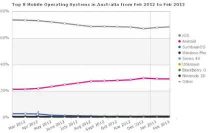
Statistics from StatCounter Global Stats (Figure 3.1) show that between February 2012
– February 2013 over 60% of mobile operating systems in Australia were iOS (Apple).
The latter portion of 2012 and commencement of 2013 shows a slight decline in the
numbers for iOS systems and a slight increase in the Android operating system
Fig This with mob inves requ Ther impo com devic The Sma hand
gure 3.1 - Top
could be a
which to c
bile phone
stigation h
uired or wh
re are suc
ossible to
es to mob
ces and se
basic rang
artphones
dheld devic
p 8 Mobile Op
a possible
carry out m
es and ta
however t
ether rugg
ch a multit
select a d
bile data c
elect the on
ge of devic
– More a
ces for bus
perating Syst
influencing
mobile data
ablets so
here is of
gedized/wa
tude of de
evice that
capture. F
ne that wo
ces that are
and more p
siness and
tems in Austr Global S
g factor fo
a capture.
the ques
f course t
aterproof e
evices in t
is widely
For most c
orks best an
e present i
people are
d personal
ralia from Feb Stats)
r SunWate
At presen
stion of w
the issue
nclosures
the market
used and
companies
nd is most
n the mark
e adopting
use (TOA
b 2012 - Feb 2
er when ch
nt SunWate
which devi
of whethe
would suff
t at the m
accepted
it’s a cas
cost effec
ket today a
smartpho
Technolog
2013 (Source
hoosing a m
er is utilisin
ice may
er a rugge
fice.
moment tha
in the ind
se of trial
ctive. are: ones, table gies 2012) e StatCounter mobile dev
ng Apple iO
require lit
ed device
at it’s almo
ustry when
a number
ets and oth
[image:34.595.104.521.128.394.2]DISSERTATION
DEVELOPMENT AND EVALUATION OF A FIELD MOBILITY DATA CAPTURE SYSTEM FOR CONDITION ASSESSMENT OF ASSETS
USQ Dissertation
Fiona Nielson May 2013
[image:35.595.345.532.108.261.2]0050041245 Commercial In Confidence Page 25
Figure 3.2 - Apple iPhone 5 Smartphone (Apple 2013)
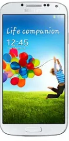
Figure 3.3 - Samsung Galaxy S4 Smartphone (Samsung 2013)
Tablets – These devices are handheld touchscreen computers similar to iPad’s,
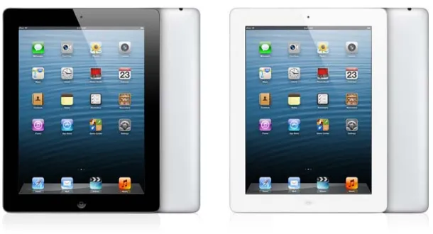
[image:35.595.131.202.313.458.2]Figure 3.4 - Apple iPad Tablet (Apple 2013)
Figure 3.5 - Microsoft Surface Tablet (Microsoft 2013)
[image:36.595.219.416.501.644.2]DISSERTATION
DEVELOPMENT AND EVALUATION OF A FIELD MOBILITY DATA CAPTURE SYSTEM FOR CONDITION ASSESSMENT OF ASSETS
USQ Dissertation
Fiona Nielson May 2013
0050041245 Commercial In Confidence Page 27
Rugged Tablets/Handhelds – These are rugged versions of tablets/handheld devices
[image:37.595.197.443.176.332.2]often with waterproof and dustproof enclosures and gorilla glass fronts to resist any sort of shock or rough treatment.
Figure 3.7 - Trimble Yuma Rugged Tablet (Trimble 2013)
[image:37.595.270.369.395.615.2]Laptops – These have been around since the early 1980’s and were the beginning of
[image:38.595.198.430.166.383.2]the mobile workforce.
Figure 3.9 - Dell Inspiron 17 Laptop (Dell 2013)
Rugged Laptops – Again these are just a rugged version of the laptop with sturdier
enclosure and glass and are often mounted in vehicles.
[image:38.595.235.401.489.666.2]DISSERTATION
DEVELOPMENT AND EVALUATION OF A FIELD MOBILITY DATA CAPTURE SYSTEM FOR CONDITION ASSESSMENT OF ASSETS
USQ Dissertation
Fiona Nielson May 2013
0050041245 Commercial In Confidence Page 29
Device Casing – Shock and waterproof cases can also be purchased for devices more
susceptible to the elements making them more suitable for use in the field. Anti-glare
screen guards can also be utilised for outdoor work.
For the specific role of carrying out condition assessments in SunWater it is likely that a
mainstream mobile phone or tablet with ruggedized enclosure would be appropriate.
The staff who carry out these condition assessments would be actively using these
devices in the field for approximately 20% of the year. This would suggest that the
larger capital outlay for a specifically ruggedized device would be unnecessary. The
mainstream devices can also be used to remotely connect to SunWater’s network
enabling alternate business use such as checking emails, working on documents etc.
This multi-use advantage makes the purchase of a ruggedized device solely for
condition assessments unrealistic. A ruggedized device is also likely to be a bulky and
cumbersome apparatus to carry in the field. As discussed by (Risk, K. Dalkia 2012)
‘Ruggedized devices had been trialled in the past but tended to remain in the car or in
the tool box - not always at hand.’ Its hoped to avoid this scenario by selecting a device
that staff will enjoy using.
APPENDIX E provides a comparison chart of the types of mobile devices that were
investigated as part of this thesis. This provides a basis for the selection of a mobile
device. Since the creation of this matrix however several of the devices have since
been upgraded. This continual hardware upgrade is a point for consideration for
organisations when looking towards a mobile data capture system. This matrix is also a
guide and it’s recommended that devices be trialled in the field before a decision is
made on the final product. As discussed in Section 4.1 initial impressions of a device
can change when it comes to actually using the device.
3.2.2 The Software
It has become evident from listening to and researching numerous case studies (see
References) that there are a number of points for consideration before implementing a
The system needs to be able to work offline – It’s evident from the Telstra Network
Coverage map (Figure 3.11) that ubiquitous network coverage across Queensland is
unrealistic at this point in time. For this very reason the mobile system needs to be able
to work offline and re-sync when re-entering an area with network coverage. (Huff. K et
al., 2000) discusses, “In mobile environments, constant connectivity is too strict a
requirement. It is desirable to support a client-side activity execution mechanism for
mobile workers to perform work activities in a disconnected mode.” Even at this time it
was evident that disconnected editing was essential for mobile workforce success.
Telstra states “Like any other mobile network, coverage on the Telstra Mobile Network
DISSE DEVE SYST USQ Fiona 00500 Figur ERTATION ELOPMENT A TEM FOR CON
Nielson 041245 re 3.11 - Telst
No data
where d
process
The sof
iOS) –
scenario
indepen
upgrade
The sys
mobile
that ties
AND EVALUAT NDITION ASS
tra Network C
a loss – Th
data can
ses if it beg
ftware shou
This crite
o that is b
ndent softw
ed as regu
stem need
data captu
s into exist
TION OF A FIE SESSMENT O
C Coverage in Q
he system
be lost. T
gins to lose
uld be plat
eria is mo
becoming
ware redu
larly as a p
ds to be b
ure problem ting corpor ELD MOBILIT OF ASSETS Dissert Commercial In Queensland (T
m needs to
The syste
e data thro
tform indep
ore to sati
more and
ces the li
platform sp
better than
m. It can
rate softwa
TY DATA CAP
tation
n Confidence Telstra 2013)
be able to
m will bec
ugh covera
pendent (i.
sfy the B
d more po
kelihood t
pecific syst
n pen and
often be
are. This
PTURE
o support
come less
age loss o
e will work
ring Your
opular in t
that the sy
tem.
paper - T
a costly ta
can mean
a number
s efficient
r device fa
k on Andro
Own Dev
the industr
ystem will
This is the
ask to crea
n that com
May 2 Page of scenar than manu ailure. oid, Window vice (BYO
ry. Platfo
need to
e crux of t
ate a syste
[image:41.595.89.531.111.438.2]for an application that is merely a replacement of pen and paper. For example
the staff go into the field, record data on their device and then manually upload
and sort the data in the office.
Currently both SAP and ESRI have off the shelf mobile applications that could possibly
be suitable to carry out the tasks required for the condition assessment. As they stand
neither solutions satisfy integration between the two software packages without
expensive customisation. “Many advances have been observed in both fields but no
direct integration was accomplished due to the complexity involved in handling each
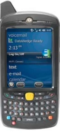
system.” (Abou-Ghanem, M. et al., 2008). The best option for SunWater in terms of
trialling a mobile device is to utilise the ESRI application, ArcGIS mobile, as this
provides integration into our corporate GIS systems and provides an easy upload
solution into SAP. At this point in time the SAP applications do not appropriately
communicate with the ESRI software.
3.3 ASSET MANAGEMENT
Asset Management is a necessary role in the business of managing assets and can be
further described as Infrastructure Asset Management. Austroads 2009 describe
Infrastructure Asset Management as:
"A systematic process of effectively maintaining, upgrading and operating assets,
combining engineering principles with sound business practice and economic rationale,
and providing the tools to facilitate a more organised and flexible approach to making
decisions necessary to achieve the public's expectations."
This asset management function divests into asset management plans which in the
case of SunWater involves the implementation of maintenance which is in turn
scheduled on the basis of condition assessment of assets.
Geraerds (1985) defined maintenance as “all activities aimed at keeping an item in, or
DISSERTATION
DEVELOPMENT AND EVALUATION OF A FIELD MOBILITY DATA CAPTURE SYSTEM FOR CONDITION ASSESSMENT OF ASSETS
USQ Dissertation
Fiona Nielson May 2013
0050041245 Commercial In Confidence Page 33
function.”
Maintenance Engineering Society of Australia (MESA) recognises this same function
as, “the engineering decisions and associated actions necessary and sufficient for the
optimization of specified capability.”
These engineering decisions and activities aimed at keeping an item fit for purpose are
achieved by SunWater, in-part, through the use of condition assessments. Whilst these
condition assessments and the process to undertake them currently fulfil their purpose,
Jardine and Tsang (2006) state “the business imperative for organisations seeking to
achieve performance excellence demand that these organisations continuously
enhance their capability to create value for customers and improve the
cost-effectiveness of their operations.”
This supports the view that performance is achieved through the enhancement of
processes and therefore encourages the possible implementation or investigation of a
mobile data capture system in an effort to enhance and improve the cost effectiveness
of operations.
3.4 SUMMARY
In order to provide a tactical and strategic direction for maintenance of SunWater’s
extensive infrastructure base asset management is necessary. If condition
assessments are suitably completed as part of this asset management, scheduling and
effective planning of asset maintenance can occur. This maintenance in turn will
4.0 DEVELOPING
THE
MOBILE
DATA CAPTURE TRIAL SYSTEM
Following the research discussed in Section 0 and utilising the project objectives to
frame the methodology the following processes were carried out to develop the mobile
data capture trial system.
4.1 THE DEVICE
Initially it was decided that the Trimble Yuma rugged tablet currently owned by
SunWater would be used to carry out the trial as it was a Windows based device and
would complement ArcGIS Mobile which is designed to run in a Windows operating
environment.
After obtaining the Trimble device and attempting to carry out basic tasks within the
office it became obvious that this was not the ideal solution for mobile data capture,
even for a trial.
The device, which is now three to four years old, runs a Windows 7 operating
environment on a seven inch screen with stylus. The difficulty that arose with this
device was that selecting buttons and performing actions on such a small screen was
quite difficult, even in an office based environment. The stylus is quite small with a very
fine end which helps with the fine motor skills required however this type of delicate
operation is not at all ideal in the field.
The decision to not proceed with the Trimble device was a difficult one as the selected
software, ArcGIS Mobile, is windows based. Discussions with an ESRI employee about
the situation revealed an alternative solution. This solution allowed for the use of mobile
devices and tablets that were either Android or iOS based. As a result it was decided
that a personal iPad would be utilised for the purposes of the trial.
The decision to use a mainstream mobile device has ensured that the trial will provide
DISSERTATION
DEVELOPMENT AND EVALUATION OF A FIELD MOBILITY DATA CAPTURE SYSTEM FOR CONDITION ASSESSMENT OF ASSETS
USQ Dissertation
Fiona Nielson May 2013
0050041245 Commercial In Confidence Page 35
comparison between this device and other mobile capture instruments can be seen in
APPENDIX E.
4.2 THE SOFTWARE
As discussed in Section 4.1 the decision to move away from utilising ESRI’s ArcGIS
Mobile software was due to the change in device. As a Windows based device was no
longer being utilised and alternative software was required.
As mentioned previously discussions with an ESRI employee revealed another
arrangement that could be utilised for the trial. This alternative is the Collector App.
The Collector App can operate on an iOS or Android system and provides an adequate
solution for the trial.
When comparing the Collector App to the other software that was investigated it is
apparent that the current version doesn’t meet all the criteria that are desirable (See
APPENDIX F). At present the application does not support disconnected editing, it
does not have a standalone iPad version (however the iPhone App can be used on the
iPad) and it does not integrate with SAP. ESRI however are due to release in late
October 2013, the Collector App v10.2. This upgrade will include a standalone iPad
version of the application (ArcGIS Resources 2013). Despite the limitations of the
current application it has provided adequate basis for completion of a trial mobile data
capture system.
The Collector App works through an ArcGIS Online account. Organizations with
desktop licenses of ESRI ArcMap are automatically assigned ArcGIS logins for each
license they have purchased. Unfortunately for the purposes of this trial the ArcGIS
Online subscriptions have not yet been released for SunWater so a 30 day trial account
was utilised. This trial account provided the full functionality of a registered ArcGIS
4.3 DATA DEVELOPMENT AND QUALITY CONTROL
In the initial stages of the project it was realised that there was a need for data
correlation between our SAP asset register and our Corporate GIS systems. For the
purposes of the trial a data dump was taken from SAP that listed every asset relevant to
Irrigation and Drainage in the Burdekin Haughton Water Supply Scheme (BHWSS).
This formed the point of truth for the number of assets required for assessment.
In order to successfully incorporate this data with the Collector App, each asset needed
a geographical location. SunWater already houses a comprehensive database of
geospatial information related to its assets however due to the age of this data and
SunWater’s ever evolving asset base, approximately 60% of the assets have linked
geographical locations.
In order to rectify this situation an overhaul of the Corporate GIS data was required for
the BHWSS. This involved exporting the attributes from our BHWSS_Assets
featureclass in ESRI to create an excel spreadsheet that was linkable with the asset
data dump from SAP.
The unique identifier between both GIS and SAP was the asset’s Object Number. This
is always the point of truth for linkages between separate asset data sources.
SunWater’s assets have additional naming conventions that often evolve and are
upgraded however fortunately the Object Number always remains the point of truth.
As mentioned previously this link provided about a 60% success rate leaving 40% of the
assets without a geographical location. This failure to link or missing data can also be
due to the structure and sub-structure of assets within SAP.
SunWater’s assets are broken down into a tiered type arrangement where there is a
header, a structure and then sub-components of that structure. Each of these tiers
have Object Numbers. For example a regulator gate may be broken down as shown:
DISSERTATION
DEVELOPMENT AND EVALUATION OF A FIELD MOBILITY DATA CAPTURE SYSTEM FOR CONDITION ASSESSMENT OF ASSETS
USQ Dissertation
Fiona Nielson May 2013
0050041245 Commercial In Confidence Page 37
Concrete Structure – STRUCTURE
Safety Screen – SUB COMPONENT
Depending on how this asset was initially located in GIS its likely that only one
component of the regulator gate was recorded. This is problematic as each component
of that structure needs to be assessed and often each component will have different
assessment intervals. For example the metal safety screen will need to be assessed at
more regular intervals than the concrete structure.
When condition assessing is carried out it is desirable that each component has a
geographical location. If only the header has a location this leads to a very time
consuming process to search through each asset, determine its header and hence
determine its geographical location. This is one of the reasons that providing
geographical locations for condition assessments at present is so time consuming.
In order to rectify this in the BHWSS data a visual inspection of the spread sheet data
could quickly be made to determine which assets could be linked together to share the
same coordinates. This process meant that approximately 80% of the assets had
geographical locations.
Finally the distance data provided in SAP allowed for a geoprocessing solution in
ArcMap to locate the remaining assets. This meant that a specific tool in ArcMap,
namely ‘Locate Route Events’ could be used to locate these missing assets along
SunWater channel centrelines using the distances recorded in SAP as locators. This
process resulted in 90% of the assets having geographical locations. The remaining
10% were unable to be located due to missing data in SAP and would require individual
research and exploration of design drawings to determine their location. This would be
a time consuming process and was not necessary for this trial.
Evidently while this project has been in progress an upgrade of the condition
assessment methodology of assets in SAP (the BILL project) has been carried out.
if SunWater decided to proceed with a mobile data capture system. For the purposes of
the trial however the data will remain as is.
4.4 ARCMAP – SETTING DOMAINS AND SUBTYPES
With the development of a strong asset da