Integrating satellite and ancillary data to predict site quality
Full text
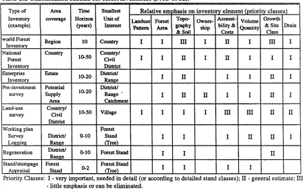
Figure


Outline
Related documents
A prospective study of thirty myofascial trigger points in upper trapezius were considered to determine the effectiveness of transcutaneous electrical nerve stimulation and
Covered Medical and Hospital Benefits Rocky Mountain Green Plan (Cost) Rocky Mountain Thrifty Plan (Cost) Rocky Mountain Standard Plan (Cost) Rocky Mountain Plus Plan
● From the Start/Finish at the River House Barn, head south and cross Fig Ave into the River Campground and head EAST and connect with Main Loop trail.. ● The main loop trail will
- heart block or sick sinus syndrome - renal or hepatic dysfunction - pregnancy or lactation Adverse Effects3. - CNS effects - GI effects -
Keywords: luxury consumption motivation, attached foreign emotional value, fashion difference perception, price fairness perception, the match degree between country
The primary findings of the study which will be discussed include the presence of an early association between adoptive parental depression and child symptoms of psychopathology,
