1. INTRODUCTION
Accurate predictions of changes to coastal ecosystem area and health, including in response to climate
change effects such as projected relative sea level rise, enables advanced planning appropriate for specific sections of coastline to minimize and offset anticipated losses, and reduce threats to coastal development and
© Inter-Research 2006 · www.int-res.com *Email: egilman@utas.edu.au
Adapting to Pacific Island mangrove responses to
sea level rise and climate change
Eric L. Gilman
1,15,*, Joanna Ellison
1, Vainuupo Jungblut
2, Hanneke Van Lavieren
3,
Lisette Wilson
4, Francis Areki
5, Genevieve Brighouse
6, John Bungitak
7, Eunice Dus
8,
Marion Henry
9, Mandes Kilman
10, Elizabeth Matthews
11, Ierupaala Sauni Jr.
6,
Nenenteiti Teariki-Ruatu
12, Sione Tukia
13, Kathy Yuknavage
141University of Tasmania, School of Geography and Environmental Studies, Locked Bag 1-376 Launceston, Tasmania 7250, Australia 2Secretariat of the Pacific Regional Environment Programme, PO Box 240, Apia, Samoa
3United Nations Environment Programme, Regional Seas Programme, PO Box 30552 Room T-232, Nairobi, Kenya 4WWF-South Pacific, PO Box 8280, Boroko, NCD, Papua New Guinea
5WWF-Fiji, 4 Ma’afu Street, Private Mail Bag, Suva, Fiji
6Coastal Management Program, Utulei Executive Office Building, Pago Pago, American Samoa 96799, USA 7Environmental Protection Authority, PO Box 1322, Majuro, MH 96960, Republic of the Marshall Islands
8Wildlife Conservation Society, PO Box 277, Goroka, Eastern Highlands Province, Papua New Guinea 9Department of Economic Affairs, PO Box PS12, Palikir, Pohnpei, FM 96941, Federated States of Micronesia
10Primary Resources Consulting Company, PO Box 1691, Port Vila, Vanuatu 11Palau Conservation Society, Box 1811, Koror, PW 96940, Palau
12Ministry of Environment, Land, and Agricultural Development, PO Box 234, Bikenibeu, Tarawa, Kiribati 13Department of Environment, PO Box 917, Nuku’alofa, Tonga
14Commonwealth of the Northern Mariana Islands Coastal Resources Management Office, Box 10007, Saipan MP 96950, USA 15Present address: 2718 Napuaa Place, Honolulu, Hawaii 96822, USA
ABSTRACT: Stresses associated with effects of climate change, including rise in relative mean sea level, pre-sent one set of threats to mangroves. Coastal development and ecosystems in the Pacific Islands region are particularly vulnerable to climate change effects. We investigated the capacity of Pacific Island countries and territories to assess mangrove vulnerability to the effects of climate change, and their capacity to adapt to mangrove responses to these forces. Technical and institutional capacity-building priorities include: (1) strengthening management frameworks to conduct site-specific assessment of mangrove vulnerability and incorporate resulting information into land-use plans to prepare for any landward mangrove migration and offsetting anticipated losses; (2) reducing and eliminating stresses on and rehabilitating mangroves, in part, to increase mangrove resilience to climate change effects; and (3) augmenting abilities to establish mangrove baselines, and monitor gradual changes using standardized techniques through a regional net-work to distinguish local and climate change effects on mangroves. Other priorities are to: (4) assess how mangrove margins have changed over recent decades; (5) determine projections of trends in mean relative sea level and trends in the frequency and elevation of extreme high water events; (6) measure trends in changes in elevations of mangrove surfaces; and (7) incorporate this information into land-use planning pro-cesses. Also in (8) some locations require spatial imagery showing topography and locations of mangroves and coastal development. Land-use planners can use information from assessments predicting shoreline responses to projected sea level rise and other climate change effects to reduce risks to coastal development, human safety, and coastal ecosystems. This advanced planning enables coastal managers to minimize social disruption and cost, minimize losses of valued coastal ecosystems, and maximize available options.
KEY WORDS: Mangrove · Sea level rise · Climate change · Land-use planning · Pacific Islands
human safety (Titus 1991, Mullane & Suzuki 1997, Elli-son 2004, Gilman et al. in press). Relative sea level rise is a major factor contributing to recent losses and pro-jected future reductions in the area of valued coastal habitats, including mangroves and other tidal wet-lands, with concomitant increased threat to human safety and shoreline development from coastal hazards (Gilman et al. in press). Global sea level rise is one of the more certain outcomes of global warming; 10 to 20 cm occurred during the last century, and several cli-mate models project an accelerated rate of sea level rise over coming decades (Church et al. 2001, 2004a, Holgate & Woodworth 2004).
Over the past few decades, the 10 countries and territories with native mangroves in the Pacific Islands region experienced an average rise in relative sea
level of 2 mm yr–1. Based on general estimates of
man-grove sedimentation rates (Ellison & Stoddart 1991), and the possibility that subsurface sediment subsi-dence from organic matter decomposition, sediment compaction, and fluctuations in sediment water stor-age and water table levels may result in substantially higher rates of sea level rise relative to the mangrove surface (Krauss et al. 2003), island mangroves could experience serious problems due to rising sea level, and low island mangroves may already be under stress. Gilman et al. (in press) determine that American Samoa could experience a 50% loss in mangrove area by the year 2100. A 12% reduction is possible in the Pacific Islands region due to mangrove responses to relative sea level rise when employing the Intergovern-mental Panel on Climate Change’s upper projection for global sea level rise through the year 2100.
Shoreline development and coastal ecosystems are particularly vulnerable to small increases in sea level and other climate change effects in the Pacific Islands region. Many of the low islands do not exceed 4 m above current mean sea level, and even on high islands, most development is located on narrow coastal plains. Small island states have limited capacity to adapt to relative sea level rise, including accommo-dating landward migration of mangroves and other coastal ecosystems. This is a result of their small land mass, high population densities and population growth rates, limited funds, poorly developed infrastructure, and susceptibility to damage from natural disasters (Nurse et al. 2001). It may not be physically or economically feasible for many small island state com-munities to retreat from a landward-migrating man-grove and other coastal habitats, or to establish zoning setbacks from coastal habitats for new development.
Pacific Island governments have recognized the value of mangroves and the need to augment conser-vation efforts (e.g. South Pacific Regional Environment Programme 1999a). The Pacific Islands contain roughly
3% of the world’s mangrove area, a small area in global terms, but each island group has a unique grove community structure (Ellison 2000) and man-groves provide site-specific functions and values (e.g. Lewis 1992, Gilman 1998). Reduced mangrove area and health will increase the threat to human safety and shoreline development from coastal hazards such as erosion, flooding, and storm waves and surges. Man-grove loss will also reduce coastal water quality and biodiversity, eliminate fish and crustacean nursery habitat, adversely affect adjacent coastal habitats, and eliminate a major resource for human communities that traditionally rely on mangroves for numerous products and services (Ramsar Secretariat 2001). Man-grove destruction can also release large quantities of stored carbon and exacerbate global warming trends (Ramsar Secretariat 2001).
Land-use planners can obtain information from assessments predicting shoreline responses to pro-jected relative sea level rise and other climate change effects over coming decades to mitigate anticipated losses of coastal habitats and avoid and minimize dam-age to coastal development. In this study, we assess the capacity of Pacific Island countries and territories to determine vulnerability and adapt to mangrove re-sponses to climate change effects. Results highlight priority technical and institutional capacity-building needs nationally and regionally.
1.1. Mangrove responses to relative sea level rise and other climate change effects
(B) Relative sea level drop:When sea level is drop-ping relative to the mangrove surface, this forces the mangrove seaward and landward boundaries to migrate seaward (Fig. 1B). The mangrove may also expand laterally if areas adjacent to the mangrove, which are currently at a lower elevation than the man-grove surface, develop hydrologic conditions (period, depth and frequency of inundation) suitable for man-grove establishment.
(C) Relative sea level rise:If sea level is rising rela-tive to the mangrove surface, the mangrove’s seaward and landward margins retreat landward where un-obstructed, as mangrove species zones migrate inland in concert with migrating environmental conditions, such as period, frequency and depth of inundation and salinity (Fig. 1C). The mangrove may also expand laterally if areas adjacent to the mangrove, which are
currently at a higher elevation than the mangrove sur-face, develop a suitable hydrologic regime. Depending on the ability of individual true mangrove species to colonize newly available habitat at a rate that keeps pace with the rate of relative sea level rise, the slope of adjacent land and the presence of any obstacles to landward migration of the landward boundary of the mangrove, such as seawalls and other shoreline pro-tection structures, some sites will revert to a narrow mangrove fringe or experience extirpation of the man-grove community (Fig. 1D).
However, over small temporal and spatial scales, and where natural and anthropogenic forces other than changing relative sea level exert a larger influence on mangrove margin position, change in mangrove position will be variable (SCOR Working Group 1991, Woodroffe 1995, Gilman et al. in press). For example, forces affect-ing sediment-budget balances, includ-ing changes in sediment budgets from rivers, variations in coastal currents, wind directions and strength, and con-struction of seawalls and other shoreline erosion control structures, can produce erosion or accretion of the mangrove seaward margin irrespective of any change in sea level.
In addition to altered sediment inputs, several other forces can affect mangrove margin position, as well as their structure and health. Outcomes of global climate change besides global sea level rise, such as changes in pre-cipitation and resulting alterations to the mangrove salinity gradient, in-creases in air and sea surface tempera-tures, changes in frequency and in-tensity of storms, changes in prevailing ocean wave heights and direction, and changes in tidal regimes may affect coastal systems, including mangroves. For instance, Snedaker (1993) hypo-thesizes that the mangrove species
Rhizophora mangle will increase peat
[image:3.612.56.363.304.710.2]tion will have a smaller water input to groundwater and less freshwater surface water input to mangroves, increasing salinity. Increased salinity decreases man-grove net primary productivity, growth, and seedling survival, and may possibly change competition be-tween mangrove species (Ellison 2000, 2004). De-creased rainfall and inDe-creased evaporation will reduce the extent of mangrove areas, with a conversion of landward zones to hypersaline flats, and there will be a decrease in diversity of mangrove zones and growth (Ellison 2000). Mangrove areas experiencing increased rainfall will experience an increase in area, with mangrove colonization of previously unvegetated areas of the landward fringe, and there will be an increase in diversity of mangrove zones and growth rates (Ellison 2000). Areas with higher rainfall have higher mangrove diversity and productivity due to higher supply of fluvial sediment and nutrients, as well as reduced exposure to sulfate and reduced sal-inity (McKee 1993, Snedaker 1993, Ellison 2000, 2004). However, projected changes to these other global cli-mate parameters, including Pacific precipitation pat-terns, are less certain than global change in sea level, and the response of mangroves and other coastal sys-tems to these changes are not well understood (Ellison 2000, Houghton et al. 2001, McLean et al. 2001).
Other forces that can affect mangroves include changing nutrient, freshwater, and pollutant inputs, clearing of mangrove vegetation, filling, displacing native species with alien invasive species, and vege-tation loss from insect infesvege-tations, fungal flora pathogens, and other diseases (Ellison 1993, 1999, Gilman 1999, Saintilan & Wilton 2001). These pres-sures can also reduce mangrove resilience to the addi-tional stress of relative sea level rise and other climate change effects. The projected increase in the fre-quency and elevations of extreme high water events in response to climate change (Church et al. 2001, 2004b, Woodworth & Blackman 2002, 2004, Gilman et al. 2005) could also affect the position and health of man-groves by altering salinity, recruitment, and inunda-tion, in addition to changing the wetland sediment budget.
Also, degradation of adjacent coastal ecosystems from relative sea level rise and climate change may reduce mangrove health. Mangroves are functionally linked to neighboring coastal ecosystems, including seagrass beds, coral reefs, and upland habitat, although the functional links are not fully understood. For instance, mangroves of low islands and atolls, which receive a proportion of sediment supply from coral reefs, may experience lower sedimentation rates and increased susceptibility to relative sea level rise if coral reefs become less productive due to climate change effects.
1.2. National, regional and international initiatives
Due to anticipated effects of climate change in the Pacific Islands region (Fig. 2), several international and regional initiatives discuss the severity of this threat and provide general guidelines for planning. However, there have been few site-based vulnerability assess-ments and few planning initiatives to manage man-groves responses to sea level rise and other climate change effects.
There have been several national or island-scale vulnerability assessments in Pacific Island countries and territories that provide qualitative assessments to describe the anticipated responses of coastal systems to projected sea level and other climate change effects and concomitant threats to developed portions of the coastal zone. For example, Phillips (2000) describes the vulnerability of Vanuatu’s coastal villages to sea level rise, referencing global sea level rise models produced by the Intergovernmental Panel on Climate Change and other projected global climate change parameters (temperature and precipitation), as a basis for hypoth-esizing possible environmental, social, and economic effects. Other vulnerability assessments have estab-lished the locations and elevations of coastal habitats and development, and use global or relative sea level change projections to make rough predictions of the sections of coastline that will be affected. For example, Solomon et al. (1997) create a geographic information system (GIS) of a developed stretch of the coastline of Viti Levu, Fiji using topographic maps to identify the locations and elevations of coastal development, including sea walls, revetments, and other shoreline protective structures. They then use this GIS to assess the vulnerability of the coastline to inundation from 4 sea level rise scenarios (a rise of 0, 0.25, 0.5 and 1 m) and storm surges. This approach to conducting a vul-nerability assessment does not incorporate natural coastal ecosystem response to changes in relative sea level and other climate change effects.
Papua New Guinea Government 2000, Republic of the Marshall Islands Environmental Protection Authority 2000, Republic of Palau Office of Environmental Response and Coordination 2002, Solomon Islands Government 2004, Kingdom of Tonga 2005). A review of these reports highlights that there is a gap in infor-mation on anticipated site-specific responses of man-groves and other coastal ecosystems to climate change effects and site-specific strategies for adaptation. Examples of some of the general adaptation strategies to manage mangrove and other coastal ecosystem responses to climate change effects identified in sev-eral of these national communication reports include: • Establishing zoning rules for setbacks of new
devel-opment from mangroves
• Retreating to higher ground or off-island for appro-priate sections of coastline as a last resort
• Identifying sections of coastal areas vulnerable to flooding and inundation to guide future development • Fortifying relevant sections of developed coastline
These examples are representative of the level of specificity in the National Communication reports to assess the vulnerability of and adapt to coastal
ecosys-tem response to sea level and other climate change effects.
The South Pacific Sea Level and Climate Monitoring Project was initiated in 1991 to establish stations in 11 Pacific Island countries to measure the relative motions of land and sea at each station (South Pacific Sea Level and Climate Monitoring Project 2001). The project is managed by the National Tidal Facility of Flinders University of South Australia. These data will assist in long-term calibration of satellite altimetry and provide a measure of regional vertical control.
[image:5.612.56.540.83.413.2]this program, SPREP (2000) presents general guide-lines for Pacific Island governments to incorporate considerations of sea level and climate change into new development planning.
The Regional Wetlands Action Plan for the Pacific Islands (SPREP 1999a) specifies regional actions to monitor mangroves. Action 3.3.1 calls for the develop-ment of a regional monitoring program to assess the status of mangroves in the region, evaluate the success of management and conservation actions, and develop more effective management practices. Furthermore, Action 3.3.5 identifies that mangrove swamps, particu-larly those of low islands, are likely to be sensitive to rise in sea level. It promotes the development of a man-grove monitoring network for identification of changes, which has yet to be established.
SPREP implemented the project Capacity Building for the Development of Adaptation Measures in Pacific Island Countries, in the Cook Islands, Fiji, Samoa, and Vanuatu from 2002–2005. The project’s aim was to build capacity of communities in these 4 countries to adapt to climate change, including incorporation of cli-mate change adaptation considerations into national and local planning and budgeting. The project focused on socioeconomic effects and policy development, and did not address coastal ecosystem response to sea level and climate change forces. For instance, SPREP con-ducted seminars for senior government officials from the 4 participating countries and produced and distri-buted briefing papers and educational materials to raise awareness of climate change effects and adapta-tion (Secretariat of the Pacific Regional Environment Programme 2003).
The South Pacific Applied Geoscience Commission (SOPAC) has developed an environmental vulnerabil-ity index for application at national scales to provide a quick and inexpensive method to characterize the vulnerability of natural systems at large scales. It is not designed for site-based vulnerability assess-ments (SOPAC 2003).
2. CAPACITY-BUILDING PRIORITIES
We collected information from 10 of the 16 Pacific Island countries and territories with indigenous mangroves to identify capacity-building priorities to address mangrove responses to climate change effects (Fig. 2): American Samoa, Fiji Islands, Kiribati, Mar-shall Islands, Federated States of Micronesia, Northern Mariana Islands, Palau, Papua New Guinea, Tonga and Vanuatu. These 10 countries and territories con-tain 84% of the region’s indigenous mangroves (Gil-man et al. in press). Table 1 provides a synthesis of the case study results. This section describes: (1) the
tech-nical resources needed for the best possible prediction of how a mangrove wetland will respond to projected relative sea level rise and climate change over coming decades, (2) the institutional resources needed to man-age and adapt to these mangrove responses to climate change effects, and (3) the technical and institutional areas that are in urgent need of strengthening in the Pacific Islands region.
Hawaii and Tahiti, where mangroves are human intro-ductions (Allen 1998, Ellison 1999), are not included in the assessment, because management authorities in these areas may actively control the alien invasive spe-cies (e.g. Smith 2005). While mangrove wetlands have been reported from Niue (Ellison 1999), a Niue gov-ernment focal point reported that there are no man-grove wetlands in Niue (F. Rex pers. comm.). While one
true mangrove species, Excoecaria agallocha, is
docu-mented in Niue (Yuncker 1943), this species is only found in dry littoral forest.
2.1. Analyses of tide gauge data
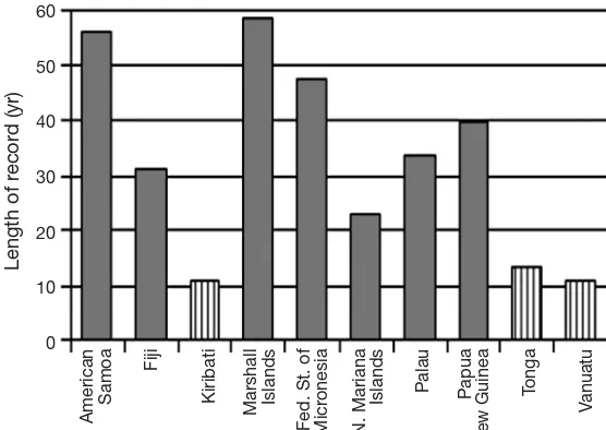
A minimum of a 20 yr local tide gauge record is required to obtain an accurate trend in relative sea level (Church et al. 2004a). Many Pacific islands expe-rience tectonic movements that result in substantial differences in local sea level relative to global eustatic trends. In addition to vertical land-level changes from tectonics, change in relative mean sea level over time as measured by a tide gauge can result from subsi-dence due to extraction of subsurface groundwater or oil, oceanographic processes such as El Niño phases and changes in offshore currents, long-term changes in regional temperature, sediment consolidation, as well as from global sea level change (Komar 1998, Church et al. 2001). The closer the tide gauge is to the mangrove site, the more accurately it will reflect the actual sea level changes that are affecting the mangroves. For sites with a local tide gauge record of < 20 yr or that are located far from the nearest tide gauge, sea level trends can be accurately calculated using the near global coverage of TOPEX/Poseidon satellite altimetry data combined with historical global tide gauge records (Church et al. 2004a). Pacific Island countries and territories also need the technical capac-ity to analyze available tide gauge data to determine projected trends in mean sea level and extreme high water events, and incorporate this information into land-use planning.
Most (7 of 10) countries and territories have
suffi-ciently long tide gauge records (≥20 yr) to determine
accurate trends in mean sea level and extreme high water events (Fig. 3). However, tide gauges of 4 of the
T
able 1. Summar
y of technical and institutional capacity of 10 Pacific Island countries and ter
ritories with indigenous mangr
ov
es to assess vulnerability and adapt to
mangr
ove r
esponses to r
elative sea level and climate change
T
echnical and institutional
American
Fiji
Kiribati
Marshall
Fed. States of
N Mariana Palau Papua T onga V anuatu capacity Samoa Islands Micr onesia Islands New Guinea
Length of tide gauge r
ecor d thr ough 56.2 31.2 11.0 58.5 47.7 23.1 33.8 39.7 13.4 10.9
Dec. 2005 (years)
a
Lar
gest distance between tide gauge
6.5 800 Unknown Unknown 563 10 700 500 17 Unknown and mangr ove (km) Per
cent of mangr
ove boundaries 100 80 22 0 2 1 100 99 Unknown 90 0
delineated and mapped (%) Year of most cur
rent mangr ove 2002 1993 1998 NA 2002 1989 1971 1993 2000 NA boundar y sur vey b Per
cent of mangr
ove islands with
100 100 22 0 100 100 87.5 86 0 100
topographic map coverage Per
cent of mangr
ove islands with
100 100 25 20 100 100 0 0 33 100
maps showing buildings, r
oads,
and other development Year of most cur
rent map showing
2001 1993 1998 2004 2004 1999 NA NA 1998 Unknown
location of development
b
Date of earliest imager
y showing 1961 1954 1960 2004 1944 1940 1946 1971 1995 1980 mangr ove mar
gin (aerial photos,
satellite imager
y
, maps)
b
Have mangr
ove sediment er
osion/ Y N N N Y N N N N N accr
etion rates been measur
ed?
Is ther
e a mangr
ove monitoring Y Y N N Y N N N Y N pr ogram? Ar e ther e in-countr y staf
f with skills
Y Y Y Y Y Y Y Y Y N
to conduct mangr
ove sur
veys and
inventories? Have mangr
oves been successfully
N Unknown Y N N Y Y N Y N rehabilitated? c Is ther
e a per
mit or zoning pr
ogram Y Y Y Y Y Y Y Y Y Y
for coastal development? Have ther
e been site-specific
man-Y N N N N N N N N N gr
ove vulnerability assessments?
Is ther
e a plan for adaptation to
N N N N N N N N N N
coastal ecosystem r
esponses to
climate change ef
fects?
aT
ide gauge r
ecor
d lengths based on the time span fr
om the earliest and most cur
rent sea level r
ecor
ds thr
ough December 2005 pos
sessed by the Per
manent Ser
vice for
Mean Sea Level and University of Hawaii Sea Level Center Joint Ar
chive for Sea Level and GLOSS/CLIV
AR Resear
ch Quality Data Set
databases. Does not account for
gaps in data r
ecor
ds. T
ide gauge r
ecor
d lengths may be longer than r
epor
ted for sites wher
e tide gauges ar
e active, as ther
e is
a lag in updating the 2 data r
epositories
bMangr
ove boundar
y sur
veys, maps showing r
oads and development, and historical imager
y may have incomplete coverage of mangr
oves
cSuccessful mangr
ove r
ehabilitation is defined as one wher
e >
25
% of the pr
oject ar
ea was successfully r
estor
ed, enhanced or cr
[image:7.612.78.534.85.721.2]gauge records are located several hundred kilometers from at least one mangrove site in that country. Three countries with tide gauge records < 20 yr require assis-tance to determine reconstructed sea level trends from satellite altimetry data combined with historical global tide gauge records (Church et al. 2004a). Agencies managing coastal land use and coastal ecosystems of Pacific Island countries and territories require assis-tance to determine trends in relative mean sea level and trends in the frequency and elevations of extreme high water events (Church et al. 2001, Woodworth & Blackman 2002, 2004, Gilman et al. 2005, in press), and assistance to interpret and incorporate this information into land-use planning.
2.2. Information on change in sea level relative to mangrove surfaces
Information on trends in the change in elevation of the mangrove surface is needed to determine how sea level has been changing in recent decades rela-tive to the mangrove surface. The most precise method to obtain information on sea level change is to install an array of tide gauges throughout a site, but this is expensive, laborious, and a minimum of a 20 yr local tide gauge record is required to obtain an accurate trend in relative sea level (Church et al.
2004a). Measurement of 137Cs and excess 210Pb
activ-ity in shallow sediment cores, observing sedimenta-tion stakes, and using soil horizon markers can pro-vide an accurate estimate of rates of change in mangrove surface elevation over recent decades (e.g.
DeLaune et al. 1978, Lee & Partridge 1983, Lynch et al. 1989, Krauss et al. 2003, Gilman et al. in press), which can then be compared to the relative sea level change rate as measured by the closest tide gauge. The measurement of radioisotope activity in mangrove sediment cores is expensive, especially if multiple cores are taken in an attempt to characterize an entire mangrove site; this method does not account for sub-surface processes that affect the elevation of the mangrove surface that occur below the depth of the cores, and there are several potential sources of error, including biotur-bation as well as abiotic processes. Alterna-tively, precision surveying from a bench-mark to points throughout a mangrove site could provide information on trends in ele-vation of the mangrove surface (Cahoon et al. 2002), which could then be compared to the relative sea level change rate from a nearby tide gauge.
American Samoa and the Federated States of Micro-nesia have some information on mangrove sedimenta-tion rates, obtained from monitoring the change in distance of the mangrove surface from the top of
sedi-mentation stakes and from determining 137Cs and
excess 210Pb activity depth profiles from shallow
sedi-ment cores (Krauss et al. 2003, Gilman et al. in press). Otherwise, regionally there is a lack of information on how sea level is changing relative to mangrove sur-faces. The mangrove surface can change in elevation from sediment accretion or erosion and from subsur-face processes, such as organic matter decomposition, sediment compaction, fluctuations in sediment water storage and water table levels, and root production (Lynch et al. 1989, Krauss et al. 2003, Rogers et al. 2005, Gilman et al. in press). Information on trends in change in the elevation of the mangrove surface over recent decades is needed.
2.3. Analysis of historical imagery to observe changes in mangrove margin positions
Analysis of a time series of recent historical aerial photographs and satellite imagery, which show the positions of mangrove seaward margins, can be used to observe trends in movement of the mangrove mar-gins (erosion or seaward progression). This informa-tion can then be used to determine if the movement has been correlated with the observed trend in relative mean sea level, and to predict the future position of the seaward margin. Extrapolation from observations of historical shoreline movement is more accurate when 60
50
40
30
20
10
0
Length of r
ecor
d (yr)
American
Samoa
Fiji
Kiribati
Marshall Islands Fed. St. of Micr
onesia
N. Mariana
Islands Palau Papua
New Guinea
T
onga
V
[image:8.612.55.333.82.279.2]anuatu
Fig. 3. Length of tide gauge records for 10 Pacific Island countries and territories with indigenous mangroves. Bars with vertical lines have a tide
the available imagery covers long time periods. The extrapolation assumes that no new large forces, such as human alterations to the coastline’s sediment bud-get, will substantially change the trend from the recent observations.
Historical imagery ≥25 yr old is available for 8
coun-tries and territories (Fig. 4). Only American Samoa has analyzed available historical imagery to observe his-torical trends in changes in position of mangrove mar-gins (Gilman et al. in press). An effort to identify addi-tional historical aerial photographs, provide IKONOS and QuickBird space imaging to in-country GIS prac-titioners, and provide assistance to co-register avail-able historical imagery to the geo-referenced
satellite imagery is needed. Some countries and territories may need assistance to estab-lish or augment capacity of a GIS program.
2.4. Mangrove boundary delineation
Periodic delineation of the mangrove land-ward margin using GPS or traditional survey techniques is needed to observe any move-ment of the boundary, providing fundamove-mental information needed to determine trends in mangrove area. Interpretation of remotely sensed imagery (aerial photos and space imaging) generally can be used to delineate the mangrove seaward margin (e.g. Gilman et al. in press), otherwise, delineation with GPS and survey equipment is needed. The world atlas of mangroves (Spalding et al. 1997; a
sec-ond edition is due in 2007) includes informa-tion on the status and trends in mangrove area.
Five of 9 countries and territories have delineated 80% or more of their mangrove boundaries (Fig. 5). Two countries have no mangrove boundary delineations. While Papua New Guinea has delineated mangrove bound-aries, the percent that has been delineated is not known, and is not included in Fig. 5. Four of the 10 countries and territories have de-lineated mangrove boundaries within the last 10 yr. This highlights the need by some coun-tries and territories to delineate mangrove boundaries at regular intervals.
2.5. Map products
Topographic information is needed to determine the mean slope of the land imme-diately adjacent to the landward mangrove margins to estimate rates of landward man-grove migration. This requires a recent delineation of the landward mangrove margin. Alternative scenarios for projected change in sea level relative to the man-grove surface can then be used to estimate the dis-tance that the landward mangrove margin will move. If sea level is rising relative to the mangrove surface, then information on the current location of any obsta-cles to the landward migration of mangroves, such as seawalls, buildings, and roads, and the distance that these structures are from the current landward man-grove margin, is needed to determine how these structures may obstruct future landward mangrove migration.
70
60
50
40
30
20
10
0
Image age (yr)
American
Samoa
Fiji
Kiribati
Marshall Islands Fed. St. of Micr
onesia
N. Mariana
Islands Palau Papua
New Guinea
T
onga
V
[image:9.612.56.331.84.281.2]anuatu
Fig. 4. Age of oldest known historical image showing the location of mangrove margins for 10 Pacific Island countries and territories with
indigenous mangroves
100
90
80
70
60
50
40
30
20
10
0
Mangr
ove ar
ea (%)
American
Samoa
Fiji
Kiribati
Marshall Islands Fed. St. of Micr
onesia
N. Mariana
Islands Palau Tonga Vanuatu
[image:9.612.263.541.503.698.2]Some countries identified a need for topographic maps and maps showing the location of roads and development in the vicinity of mangroves. Support for in-country GIS programs may be needed to produce them. Seven of the countries and territories have > 85% topographic map coverage of their mangrove islands (Fig. 6). Two lack any topographic map cover-age of their mangrove islands. Five countries and terri-tories have maps showing locations of development and roads in the vicinity of all mangroves (Fig. 7). Two countries lack maps showing development and roads next to any of their mangroves.
2.6. Mangrove monitoring, assessment and regional network
Given uncertainties about future climate change and the responses of mangroves and other coastal ecosystems, we need to manage adaptively and proactively. In-country staff with training, experience, and motivation are required to conduct monitoring and assess-ment of relevant mangrove parameters, in part, to facilitate adaptive management. Sea level and climate changes are expected to alter mangrove position, area, structure, spe-cies composition, and health. Linking national mangrove monitoring efforts through a re-gional network using standardized techniques would enable the separation of site-based influences from global changes to provide a better understanding of mangrove responses and alternatives for mitigating adverse effects (Ellison 2000, Nurse et al. 2001).
Four countries and territories identify a strong need for training and capacity-building of in-country per-sonnel in mangrove assessment and monitoring: Vanu-atu, Kiribati, Northern Mariana Islands, and Palau. Other countries (American Samoa, Tonga, Fiji, Mar-shall Islands, Papua New Guinea, and the Federated States of Micronesia) have some in-country capacity already, but identify information gaps. Fiji, Federated States of Micronesia and American Samoa conduct some monitoring of mangrove tree girth (diameter at breast height or DBH), which allows quantitative assess-ment of mangrove ecosystem change in community structure and growth rates. Palau and Tonga have more limited monitoring, such as of birds or human impacts.
There has also been no coordination in the limited mangrove monitoring. The countries and territories with a mangrove monitoring program do not employ standardized tech-niques to enable a meaningful comparison of results from the different programs. Other countries have no monitoring. There is no Pacific Islands regional mangrove monitoring program in place. All countries indicate that they would be interested in participating in a regional network to monitor mangroves and assess mangrove response to sea level rise and climate change, if such a network were established.
Establishing mangrove baselines and moni-toring gradual changes through regional net-works using standardized techniques will enable the separation of site-based influences from global changes to provide a better 100
90
80
70
60
50
40
30
20
10
0
Map coverage (%)
American
Samoa
Fiji
Kiribati
Marshall Islands Fed. St. of Micr
onesia
N. Mariana
Islands Palau Papua
New Guinea
T
onga
V
[image:10.612.55.332.83.275.2]anuatu
Fig. 6. Percentage of islands containing mangroves with topographic map coverage, for 10 Pacific island countries and territories with indigenous
mangroves
100
90
80
70
60
50
40
30
20
10
0
Per
centage
American
Samoa
Fiji
Kiribati
Marshall Islands Fed. St. of Micr
onesia
N. Mariana
Islands Palau Papua
New Guinea
T
onga
V
anuatu
Fig. 7. Percentage of islands containing mangroves with maps showing the location of development and roads, for 10 Pacific Island countries and
[image:10.612.56.333.496.690.2]understanding of mangrove responses to sea level and global climate change, and alternatives for mitigating adverse effects (Ellison 2000, Nurse et al. 2001). The monitoring system, while designed to distinguish cli-mate change effects on mangroves, would also there-fore show local effects, providing coastal managers with information to abate these sources of degradation.
Establishing a regional wetland monitoring network for the Pacific Islands region has been proposed in the Action Strategy for Nature Conservation in the Pacific Islands Region (SPREP 1999a), and the Regional Wet-lands Action Plan for the Pacific IsWet-lands (SPREP 1999b). This has not been implemented to date.
2.7. Strengthening management frameworks
Governments need the institutional capacity to man-age a land-use permit or zoning program to ensure coastal earthmoving and development activities are sustainable, including accounting for effects on man-groves, and to plan for any landward mangrove migra-tion. While existence of a coastal permit and zoning program does not necessarily mean that current legal and management frameworks and political will are adequately preventing mangrove degradation, it indi-cates that the institutional capacity needed to sus-tainably manage activities in mangroves and other sensitive coastal ecosystems exists. Given an existing coastal development permit or zoning program, if the political will exists, it could be possible to establish zoning setbacks for new coastal development adjacent to mangroves in certain sections of coastline, adopt rules on where hard versus soft engineering erosion control structures can and cannot be constructed, and determine which sections of coastline would undergo managed retreat versus fortification.
All 10 participating countries and territories report having some form of coastal permit or zoning program that regulates coastal activities such as earthmoving and development activities. The existence of a frame-work to manage coastal activities is part of the re-quisite institutional capacity to sustainably manage activities in mangroves and other sensitive coastal ecosystems. However, this does not necessarily mean that current legal and management frameworks and political will are adequately preventing mangrove de-gradation. There is a need to assess the efficacy of national management frameworks at preventing man-grove degradation to determine if this is an area in need of attention. For instance, despite the existence of a permit program for coastal development activities, the wetlands management framework in the US Commonwealth of the Northern Mariana Islands has not prevented site-specific, island-wide, or cumulative
losses of wetland functional performance or wetland area (Gilman 1998, 1999). Also, Palau’s state Public Land Authorities have been leasing and allowing the development of property containing mangroves (Republic of Palau Office of Environmental Response and Coordination 2002).
Only American Samoa has assessed the site-specific vulnerability of mangroves to sea level and climate change (Gilman et al. in press). Information from the case studies and a review of National Communication Reports to the United Nations Framework Convention on Climate Change reveal that none of the 10 countries and territories have developed a plan for adaptation to mangrove or other coastal ecosystem responses to cli-mate change effects. Technical assistance is needed to support conducting site-specific vulnerability assess-ments and to incorporate this information into land-use and master planning.
2.8. Mangrove rehabilitation
Capacity to rehabilitate (restore, enhance and cre-ate) mangroves will complement adaptation to man-grove response to sea level and climate change. Restoring areas where mangrove habitat previously existed, enhancing degraded mangroves by removing stresses that caused their decline, and creating new mangrove habitat will help to offset anticipated reduc-tions in mangrove area and increase resilience to cli-mate change effects. If successful mangrove rehabili-tation has been achieved in the past, this indicates that it may be possible to replicate this success at other sites. However, failure to provide adequate training to coastal managers in the basics of successful mangrove rehabilitation leads to project failures or projects that only partially achieve stated goals (Lewis 2005).
There has been limited activity in the region in reha-bilitation of mangroves, with small-scale successful projects only recorded from Kiribati, Northern Mari-ana Islands, Palau, and Tonga and 2 failed mangrove rehabilitation efforts in American Samoa and Papua New Guinea. The results of 2 additional rehabilitation efforts in Palau and Fiji are not known. This highlights the need for improved staff training, capacity building and information sharing.
3. SITE PLANNING AND ADAPTATION STRATEGY
rest-ricted. Managers can then incorporate the results of these vulnerability assessments into coastal land-use policies to provide adequate lead-time to minimize social disruption and cost, minimize losses of valued coastal habitats, and maximize available options. The policy adopted to manage site-based shoreline response to rising sea level will be made as part of a broader coastal planning analysis. This analysis requires balancing multiple and often conflicting objectives of managers and stakeholders to (1) sustain the provision of ecological, economic, and cultural values; (2) address priority threats to natural ecosystem functioning; (3) maintain ecological processes and biodiversity; (4) achieve sustainable development; and (5) fulfill institutional, policy, and legal needs (Gilman 2002).
Site planning for some sections of shoreline contain-ing mangroves that are not highly developed and that are experiencing a rise in relative sea level may call for abandonment and adaptation to manage long-term retreat (Dixon & Sherman 1990, Mullane & Suzuki 1997, Gilman 2002). ‘Managed retreat’ involves imple-menting land-use planning mechanisms before the effects of rising sea level become apparent, which can be planned carefully with sufficient lead time to enable economically viable, socially acceptable, and environ-mentally sound management measures. Coastal devel-opment can remain in use until the eroding coastline becomes a safety hazard or begins to prevent land-ward migration of mangroves, at which time the devel-opment can be abandoned or moved inland. Adoption of legal tools, such as rolling easements, can help make such eventual coastal abandonment more acceptable to coastal communities (Titus 1991). Zoning rules for building setbacks and land use for new development can be used to reserve zones behind current man-groves for future mangrove habitat. Managers can determine adequate setbacks by assessing site-specific rates for landward migration of the mangrove land-ward margin (Gilman et al. in press). Construction codes can be instituted to account for relative sea level rise rate projections to allow for the natural inland migration of mangroves based on a desired lifetime for the coastal development (Mullane & Suzuki 1997). Any new construction of minor coastal development struc-tures, such as sidewalks and boardwalks, should be required to be expendable with a lifetime based on the assessed sites’ erosion rate and selected setback. Otherwise, the structure should be portable. Rules could prohibit landowners of parcels along these coasts from constructing coastal engineering struc-tures to prevent coastal erosion and the natural inland migration of mangroves. This managed coastal retreat will allow mangroves to migrate and retain their natural functional processes, including protecting the coastline from wind and wave energy.
Employing shoreline erosion control measures, such as surge breakers, dune fencing, and detached break-waters, can help reduce the rate of coastal erosion (Mullane & Suzuki, 1997). Use of hard engineering technology, including groins, seawalls, revetments, and bulkheads, a traditional response to coastal ero-sion and flooding in small island states and worldwide, can increase coastal vulnerability (Fletcher et al. 1997, Mullane & Suzuki 1997, Mimura & Nunn 1998, Nurse et al. 2001). These coastal engineering structures usu-ally can effectively halt erosion as relative sea level rises, but often lead to the loss of the coastal system located in front of and immediately downstream in the direction of longshore sediment transport from the structure, converting the seaward coastal system into deepwater habitat (Fletcher et al. 1997, Mullane & Suzuki 1997). For some sites, it may be less expensive to avoid hard solutions to relative sea level rise and instead allow coastal ecosystems to migrate inland. These ecosystems provide natural coastal protection that may be more expensive to replace with artificial structures (Mimura & Nunn 1998, Ramsar Secretariat 2001). However, results of site planning may justify use of hard engineering technology and shoreline erosion control measures to prevent erosion for some sections of highly developed coastline adjacent to mangroves. As a result, the mangroves’ natural landward migra-tion will be prevented and the mangrove fronting the development will eventually be lost, along with its valued function of buffering the developed coastline from wave and wind energy.
Most cost-benefit analyses included in site planning only examine costs and benefits as measured by mar-ket prices, ignoring mangrove and other coastal sys-tem values not described by established monetary indicators (Dixon & Sherman 1990, Ramsar Secretariat 2001). Site planning and cost-benefit analyses em-ployed to determine if a section of coastline abutting a mangrove should be fortified or undergo managed retreat should account for the benefits of allowing mangroves to undergo natural landward migration under a rise in relative sea level. These benefits include the continued provision of valued services and products, including consumptive benefits, education and research, aesthetic and cultural benefits, and future values such as a mangroves future potential for tourism (Dixon & Sherman 1990, Ramsar Secretariat 2001).
Stake-holders will be more likely to comply with restrictions on their traditional resource use activities if they un-derstand and support the rules, which can be accom-plished through direct community participation in moni-toring, planning, and management decision-making. The optimal approach will depend on the local context. At some sites the rural conditions, including relatively small population size, high dependence of local com-munities on coastal and marine resources, social cohe-sion, customary tenure and traditional use of coastal and marine areas and resources, existence of strong and intact traditional authority, and low conven-tional government management capacity, make local community-based management through collaboration between local government and the local community (e.g. clans or individual villages) appropriate (White et al. 1994). In urban areas with a more heterogeneous local community, more complicated and numerous resource uses and users, more numerous external threats to the coastal and marine environment, and less recognition of customary tenure and traditional gover-nance, community-based management would be less effective and there will be a larger need for central government management.
4. CONCLUSIONS AND NEXT STEPS
To assess mangrove vulnerability to sea level rise and other climate change effects and to plan for adap-tation, Pacific Island countries and territories need to build their technical and institutional capacity to:
(1) Determine trends in relative mean sea level and trends in the frequency and elevations of extreme high water events, and incorporate this information into land-use planning processes.
(2) Measure trends in the change in mangrove sur-face elevation to determine how sea level is changing relative to the mangrove surface.
(3) Acquire and analyze historical remotely sensed imagery to observe historical trends in changes in posi-tion of mangrove margins.
(4) Produce topographic maps and maps of locations of development and roads for land parcels adjacent to and containing mangroves, and establish or augment GIS programs. The World Bank-funded Infrastructure Asset Management Project in progress in Samoa might serve as a suitable model.
(5) Develop standardized mangrove monitoring pro-grams as part of a regional mangrove-monitoring network. Provide training opportunities for in-country personnel to manage the mangrove-monitoring pro-gram, coordinate with a regional hub, and conduct monitoring techniques. Monitoring methods would include periodic delineation of mangrove margins.
(6) Assess efficacy of mangrove management frame-works and provide assistance to manage coastal activ-ities to prevent unsustainable effects on mangroves and other coastal habitats, in part, to increase resi-lience to climate change effects, and plan for any land-ward mangrove migration in response to relative sea level rise.
(7) Augment regional capacity to rehabilitate man-groves.
Establishing a regional mangrove monitoring net-work may enable many of the identified capacity-building priorities to be fulfilled, and should be one of the highest regional priorities. Participating countries and territories could share technical and financial resources to maximize monitoring and conservation benefits through economy of scale.
Assessing the efficacy of management frameworks to avoid and minimize adverse affects on mangroves and other valuable coastal ecosystems and plan for any landward mangrove migration is also critical. Ensuring that management frameworks are capable of eliminat-ing and minimizeliminat-ing stresses that degrade mangroves is necessary to provide for mangrove resilience to anticipated stresses from sea level and other climate change effects. And managers will need the institu-tional capacity to plan for site-specific mangrove response to climate change effects, such as instituting setbacks from mangroves for new development for appropriate sections of coastline. However, manage-ment frameworks will only be effective if local commu-nities and management authorities recognize the value of mangrove conservation. It is therefore also a priority to continually develop and augment a mangrove con-servation ethic.
behavior and attitudes by better informing communi-ties of the value of mangroves and other ecosystems. This increase in public knowledge of the importance of mangroves can provide the local community with information to make informed decisions about the use of their mangrove resources, and can result in grass-roots support and increased political will for measures to conserve and sustainably manage mangroves.
Acknowledgements. This project was made possible through support to E.L.G. from the United Nations Environment Pro-gramme Regional Seas ProPro-gramme and Western Pacific Regional Fishery Management Council. The authors are grateful for information provided by Taakena Redfern and Aberee Bauro of the Republic of Kiribati Ministry of Environ-ment, Land, and Agricultural Development; Frank Dayton of the US Army Corps of Engineers; Laura Williams of the CNMI Division of Fish and Wildlife; Dr. Leroy Heitz of the University of Guam Water and Environmental Research Institute; Kash-gar Rengulbai of the Palau Bureau of Agriculture; Alma Ridep-Morris of the Palau Bureau of Marine Resources; Mike Aurelio of PALARIS; Tiare Holm and Anu Gupta of the Palau Conservation Society; Yimnang Golbuu, Charlene Mersai and Steven Victor of the Palau International Coral Reef Center; Ann Kitalong of The Environment, Inc.; and Umiich Sengebau of The Nature Conservancy. Professor Richard Coleman and Dr. Werner Hennecke of the University of Tas-mania, Australia, assisted with case study designs and com-mented on drafts of this report. Serena Fortuna and Mette Loyche Wilkie, Forestry Department, Food and Agriculture Organization of the United Nations, assisted with identifying national focal points. Neil White, Commonwealth Scientific and Industrial Research Organization, provided mean sea level rates through reconstructed analysis and regression analysis of monthly mean sea levels with tidal constituents removed for some of the countries and territories included in this assessment.
LITERATURE CITED
Allen JA (1998) Mangroves as alien species: the case of Hawaii. Glob Ecol Biogeogr Lett 7:61–71
Alleng G (1998) Historical development of the Port Royal mangrove wetland, Jamaica. J Coast Res 14:951–959 Cahoon DR, Lynch JC, Perez BC, Segura B, Holland R, Stelly C, Stephenson G, Hensel P (2002) A device for high preci-sion measurement of wetland sediment elevation: II. The rod surface elevation table. J Sediment Res 72:734–739 Church J, Gregory J, Huybrechts P, Kuhn M, Lambeck K,
Nhuan M, Qin D, Woodworth P (2001) Changes in sea level. In: Houghton J, Ding Y, Griggs D, Noguer M, van der Linden P, Dai X, Maskell K, Johnson C (eds) Climate change 2001: the scientific basis. Cambridge University Press, Cambridge, p 639–693
Church J, White N, Coleman R, Lambeck K, Mitrovica J (2004a) Estimates of the regional distribution of sea level rise over the 1950 to 2000 period. J Clim 17:2609–2625 Church J, Hunter J, McInnes K, White N (2004b) Sea level
rise and the frequency of extreme events around the Australian coastline. In: Coast to Coast ‘04 – Conf Proc, p 16–24
DeLaune R, Patrick W Jr, Buresh R (1978) Sedimentation rates
determined by 137Cs dating in a rapidly accreting salt
marsh. Nature 275:532–533
Dixon JA, Sherman PB (1990) Economics of protected areas. A new look at benefits and costs. Island Press, Washing-ton, DC
Ellison J (1993) Mangrove retreat with rising sea level, Bermuda. Estuar Coast Shelf Sci 37:75–87
Ellison J (1999) Status report on Pacific island mangroves. In: Eldredge LG, Maragos JE, Holthus PL (eds) Marine and coastal biodiversity in the tropical island Pacific region: Vol 2. Population, development and conservation priorities. Pacific Science Association and East West Center, Honolulu, p 3–19
Ellison JC (2000) How South Pacific mangroves may respond to predicted climate change and sea level rise. In: Gille-spie A, Burns W (eds) Climate change in the South Pacific: impacts and responses in Australia, New Zealand, and small islands states. Kluwer Academic Publishers, Dor-drecht, p 289–301
Ellison J (2001) Possible impacts of predicted sea level rise on South Pacific mangroves. In: Noye B, Grzechnik M (eds) Sea level changes and their effects. World Scientific Pub-lishing, Singapore, p 289–301
Ellison J (2004) Vulnerability of Fiji’s mangroves and associ-ated coral reefs to climate change. University of Tasmania, Launceston
Ellison J, Stoddart D (1991) Mangrove ecosystem collapse during predicted sea level rise: holocene analogues and implications. J Coast Res 7:151–165
Federated States of Micronesia (1997) 1997 Climate Change National Communication. FSM National Government, Climate Change Program, Palikir
Fletcher CH, Mullane RA, Richmond B (1997) Beach loss along armored shorelines of Oahu, Hawaiian Islands. J Coast Res 13:209–215
Gilman EL (1998) Nationwide permit program: unknown adverse impacts on the Commonwealth of the Northern Mariana Islands’ wetlands. Coast Manag 26:253–277 Gilman EL (1999) Compensatory wetland mitigation in the CNMI: an incipient discipline. In: Streever W (ed) An international perspective on wetland rehabilitation. Kluwer Academic Publishers, New York, p 3–17
Gilman EL (2002) Guidelines for coastal and marine site-planning and examples of site-planning and management intervention tools. Ocean Coast Manag 45:377–404 Gilman E (2004) Assessing and managing coastal ecosystem
response to sea level and climate change. UNESCO World Heritage Centre Pacific Project Planning Workshop 5–9 Oct. 2004, Kiritimati Island, Kiribati. Blue Ocean Institute, New York
Gilman E, Coleman R, Hunter J (2005) Trends in frequency and elevation of extreme high water events and causes, American Samoa. University of Tasmania and American Samoa Coastal Management Program, Hobart
Gilman E, Ellison J, Coleman R (in press) Assessment of mangrove response to projected relative sea-level rise and recent historical reconstruction of shoreline position. Environ Monit Assess
Government of Samoa (1999) First National Communication Report to the UNFCCC. Department of Lands, Survey and Environment, Apia
Government of Tuvalu (1999) Tuvalu Initial National Com-munication Under the United Nations Framework Convention on Climate Change. Funafuti
Houghton J, Ding Y, Griggs D, Noguer M, van der Linden P, Dai X, Maskell K, Johnson C (eds) (2001) Climate change 2001: the scientific basis. Cambridge University Press, Cambridge
Johannes RE (1982) Traditional conservation methods and protected marine areas in Oceania. Ambio 11:258–261 Kingdom of Tonga (2005) Initial National Communication in
Response to its Commitment under the United Nations Framework Convention on Climate Change. Kingdom of Tonga
Kiribati Government (1999) Initial Communication Under the Convention. Ministry of Environment and Social Devel-opment, Tarawa
Komar P (1998) Beach processes and sedimentation, 2nd edn. Prentice Hall, Upper Saddle River, NJ
Krauss KW, Allen JA, Cahoon DR (2003) Differential rates of vertical accretion and elevation changes among aerial root types in Micronesian mangrove forests. Estuar Coast Shelf Sci 54:251–259
Lee W, Partridge T (1983) Rates of spread of Spartina anglica
and sediment accretion in the New River estuary, Inver-cargill, New Zealand. NZ J Bot 21:231–236
Lewis RR III (2005) Ecological engineering for successful management and restoration of mangrove forests. Ecol Eng 24(4 SI):403–418
Lewis RR III (1992) Scientific perspectives on on-site/off-site, in-kind/out-of-kind mitigation. In: Kusler JA, Lassonde C (eds) Effective mitigation: mitigation banks and joint projects in the context of wetland management plans. Proc Natl Wetland Symp, Palm Beach Gardens, FL, p 101–106
Lynch J, Meriwether J, McKee B, Vera-Herrera F, Twilley R (1989) Recent accretion in mangrove ecosystems based on137Cs and 210Pb. Estuaries 12:284–299
McLean R, Tsyban A, Burkett V, Codignotto J, Forbes D, Mimura N, Beamish R, Ittekkot V (2001) Coastal zones and marine ecosystems. In: McCarthy J, Canziani O, Leary N, Dokken D, White K (eds) Climate change 2001: im-pacts, adaptation, and vulnerability. Cambridge Univer-sity Press, Cambridge, p 343–378
Mimura N, Nunn P (1998) Trends of beach erosion and shore-line protection in rural Fiji. J Coast Res 14:37–46
Mullane R, Suzuki D (1997) Beach Management Plan for Maui. University of Hawaii Sea Grant Extension Service and County of Maui Planning Department, Maui
Nurse L, Sem G, Hay J, Suarez A, Wong P, Briguglio L, Ragoonaden S (2001) Small island states. In: McCarthy J, Canziani O, Leary N, Dokken D, White K (eds) Climate change 2001: impacts, adaptation, and vulnerability. Cam-bridge University Press, CamCam-bridge, p 843–875
Papua New Guinea Government (2000) Initial National Communication Under the United Nations Framework Convention on Climate Change. Government of Papua New Guinea
Phillips B (2000) Vanuatu vulnerability assessment: an approach to integrated regional assessment. In: Mimura N, Yokoki H (eds) Proc APN/SURVAS/LOICZ Joint Conf Coastal Impacts of Climate Change and Adaption in the Asia-Pacific Region, Kobe
Ramsar Secretariat (1999) Global review of wetland resources and priorities for wetland inventory. Meeting of the Con-ference of the Contracting Parties to the Convention on Wetlands, Ramsar COP7 DOC.19.3, Gland
Ramsar Secretariat (2001) Wetland values and functions: climate change mitigation. Gland
Republic of the Marshall Islands Environmental Protection Authority (2000) Initial Communication Under the United
Nations Framework Convention on Climate Change. Majuro
Republic of Nauru (1999) Climate Change Response. First National Communication under the United Nations Framework Convention on Climate Change. Yaren Republic of Palau Office of Environmental Response and
Coordination (2002) First Communication to the United Nations Framework Convention on Climate Change. Koror
Republic of Vanuatu (1999) Vanuatu National Communica-tion to the Conference of the Parties to the United NaCommunica-tions Framework Convention on Climate Change. Port Vila Rogers K, Saintilan N, Heijnis H (2005) Mangrove
encroach-ment of salt marsh in Western Port Bay, Victoria: the role of sedimentation, subsidence, and sea level rise. Estuaries 28:551–559
Saintilan N, Wilton K (2001) Changes in the distribution of mangroves and saltmarshes in Jervis Bay, Australia. Wetlands Ecol Manag 9:409–420
SCOR Working Group (1991) The response of beaches to sea level changes: a review of predictive models. J Coast Res 7:895–921
Secretariat of the Pacific Regional Environment Programme (2003) Capacity building for the development of adapta-tion measures in Pacific Island countries project. Biannual report covering the period April 1st 2003–September 30th 2003, Apia
Smith CR (2005) Recolonization and succession of wetland communities following mangrove removal. University of Hawaii Department of Oceanography, Honolulu
Snedaker S (1993) Impact on mangroves. In: Maul GA (ed) Climate change in the Intra-American Seas: implications of future climate change on the ecosystems and socio-economic structure of the marine and coastal regimes of the Caribbean Sea, Gulf of Mexico, Bahamas and N.E. Coast of South America. Edward Arnold, London, p 282–305
Solomon Islands Government (2004) Initial National Commu-nications Under the United Nations Framework Conven-tion on Climate Change. Solomon Islands Government Solomon S, Kruger J, Forbes D (1997) An approach to the
analysis of storm-surge and sea level vulnerability using GIS: Suva, Fiji, South Pacific. In: Proc 1997 Can Coast Conf. Canadian Coastal Science and Engineering Associ-ation, Ottawa
SOPAC (South Pacific Applied Geoscience Commission) (2003) Future directions for the environmental vulnerabil-ity index (EVI) project. SOPAC Secretariat, Suva SPREP (1999a) Regional wetlands action plan for the Pacific
Islands. South Pacific Regional Environment Programme, Apia
SPREP (1999b) Action strategy for nature conservation in the Pacific Islands region 1999–2002. South Pacific Regional Environment Programme, Apia
SPREP (2000) Adapting to climate change: incorporating cli-mate change adaptation into development activities in Pacific Island countries: a set of guidelines for policy-makers and development planners. South Pacific Regional Environment Programme, Apia
South Pacific Sea Level and Climate Monitoring Project (2001) Precision monitoring with the continuous global positioning system (CGPS). Australian Marine Science & Technology, Curtin
Spalding MD, Blasco F, Field CD (1997) World mangrove atlas. International Society for Mangrove Ecosystems, Okinawa
how Americans could abandon an area the size of Massa-chusetts at minimum cost. Environ Manag 15:39–58 White A, Hale L, Renard Y, Cortesi L (eds) (1994) Collaborative
and community-based management of coral reefs: lessons from experience. Kumarian Press, West Hartford, CT Woodroffe CD (1995) Response of tide-dominated mangrove
shorelines in northern Australia to anticipated sea level rise. Earth Surface Processes Landforms 20:65–85
Woodworth PL, Blackman DL (2002) Changes in extreme high water at Liverpool since 1768. Int J Climatol 22: 697–714
Woodworth PL, Blackman DL (2004) Evidence for systematic changes in extreme high waters since the mid-1970s. J Clim 17:1190–1197
Yuncker TG (1943) The flora of Niue Island. Bernice P. Bishop Museum Bulletin 178:1–126
Editorial responsibility: Joan Kleypas, Boulder, Colorado, USA