THE TECTONIC =snit! of tin
DIAL RANO AREA, TASMANIA.
ILL. 111=8 13.6e.(Nons.)
Submitted in fulfilsient of the rovirsinents for the Degree of
DOCTOR of PKILOSOPHT.
University of Tasmania, Hobart.
Mt Mon t , 0V+I t,
Stratigraphy or the Precambrian System
TABLE OV COUXEN:20 page Ma—
1- 5
5.
28 29. 4647- 73
2, Cambrian 74.133
3 0 ft Ordovician 134-164
4, " Devonian 165-118b
Secorld Voluige
pnemprrc Gy
t
oldx
,
y
5, fitructures in post-Middle Devonian rocks 179-100 6. 0 " Ordovician rocks 1C9.224
7. " Cambrinn • " 225'..n53. G. " the Roclw Cape Group 252-264 9. " Mverstone trotamorphics P65.305 10. " " Forth llott.-Lors7E•zie 306.320
IsFaCr
11. he Precambrian Orogenies 321-334
12. The Tyennan Orogeny 335-349
13. The Tanerabberan °meow • • 350-360
'Ni
zit
si
i
kaggei
369-374
&Laza;
375-386
TABLIt OF
Finn;
,tir0 Vop
Introduction
1. Locality map... ... ...
2, Map of towgrap;ic . . . .
3. Bedrock map of the Dial Range area...
Maminz.Z
4. Columnar sections of the Cat eena Subgroup 5. Isopach map of the Barrington Chart 6 General Geological map of the BE:saran
Aegabreccia. ...
chavtfir
7:. Columnar sections of the Dial Conglomerate .. 135 S Isopach nap of the Duman Conglomerate... 139 9. Structures in the Dial Conglomerate 140 10. Variations in pebble composition of the
Duncan Conglomerate. ... 148
11. Palaeogeographic reconstructions for the
160 chapter 4
12. Plan of the Eugenana Quarries.. ...,.. ... 165 13. Map of the face of Balletts Quarry, ftgenana... 170
'io-.1.4.tt•
IHMTIT1111,
14. Map of the Illamatha Colliery.. ... 181
15. Lambert projections of Tertiary Faults,
XlIamatha • 182
chanter
0
16. General geological sap of the Melrose Basin.... 189 17. Lambert projections of first generation
structures, Bugenane... ...•... ... 191 18. Profile and flow net of an incongruent fold,
Zugenana. • ... 192
19. Diagrams of strain in three lithologies,
191f
20. Lambert projections of second generation
fold structures, Eugsnane
195
TATIP,
ow nom74,
(=tinned)azinaml (continued)
21.Profiles of second Generation folds, Kwenana.... 197 22.Lambert projections of second generation
shears, Evgcnana... * . *** ... 203 23.Lambert projections of third Generation
folds, Eitvcnana 202
24,Ind= map of Sulphur Creek headland.. 206 25,Lambert projections of faults ancl beano,
Sulnhur 200
26.Lachoit projections of shear joints,
Gulphur ***** eiroloodivesoorviteeelty*WO 209 27.Lacbert projections of bedding in subareas
of the "east basin", Sulphur Creek. ois, 4041,eloomelo 210 20, Craphn of various functions of magnitude
versus the azimuth- of beta nodes at
Sulphur Creek... * *5•• ******* 212
29* Composite profiles of the Dial 216 30, Structure oontotuis ca the base of the LOina
Otuidatones Lorvier --- v ,--4/00,11■4000 464#4.090,A0 219
31.Otrueture.contaur imps Shouin3 dovelopment of
the Luncan Vault near lit Lorymer.. . * *** 221
32.Laps of superposed folds in the Gog ange
and in the High Atlas. 222
33.1-7ap of superposed foldinc in the Loyotca Dome.. 223
2hap1ax.2..
34.Uoneral geo1o7ica1 map of the Ulloonia area.. 225 35.rap and profile of the roe section across
the Isandula Fault. ... ... * ... 226 36.General ecological .rn1) of the Ubstban% Chaos... 220 37.Detail maps and Lariboit projections,
Westbam% Chaos... 229
3. Foliation in the Wcstban% 23,2
39.Utrike.line map of the Cateena point slide zone.. 23 40.Lambert projections of folds in the Catcena
Point slide 23ti,
41, Lrantert projections and profile of Tectonic
folds,
vest of Cateena 240 42. General nap and profile of road section sOucarloaf Gorge... ***** * 0. * 401110041100***-00 241
43, Detailed sections from road eutt1n3s s
bugarloaf Gorge, ***** * ... ******* 242
114 Laubert projoctions of folds and faults,
Oucrloafa Goree.„. 1114**AAAAAAPOOOOMOr0.00 ******* AO
Aa
7044 o IGTIMES (continued)
4baltax.2
(continued)46. Analytical profiles of Mt Lorymer. soaeosso*olowe. 2§6
47. Composite vertical profile of Mt L;rymer 247
Chal07 8
48. General geological map of Sulphur Creek
headland.... O *** 46w.4,rnemOkoo *
49. Lambert projections of first generation ... 253
structures, Sulphur 254
50. Lambert projections of second generation folds, as 1.4, Sulphur Creek... .... 51. Lambert projections of second generation
folds, subarea
5,
Sulphur Creek. ... 259 52. Lambert projections, synoptic, SulPiul; Creek... 260 53. Lambert projections of structures in secondgeneration fold at Blythe Heads.. 262
54.. Detail map of Rocky Cape Group in the vicinity
of Goat • 263
Chanter 9
55. Index Map of Goat Island. ....sm... 269 56. Nomanelature of morphological elements of
Tectons... OOOOOO OOOOOOOO 271 51. Shapes of Tectons, Goat la;na 272 58.Weight relationships of Tectons, Goat Island 279 59. Circumference relationships of Tectons„
Goat Island...me.... ***** 280 60. Axial lengths of Tectons, Goat Island.. *90 281 61. Eccentricities of Tectons, Goat Island 282 62. Lambert projeetions of structures in area 2,
Goat Island. • ** ** ... ** * . 286 63. Texture and grain fabric of sthist from
conglomerate matrix, area 2, Goat Island... 290 64. Map and profile of portion of area lift
Goat Island 294
65* Map and profile of areas 54, Coat
..." 295
66. Grain fabric of a quartzite from oast of
Goat Island. ** ... 297
67. Structural-alement map of Goat Island
(lithologies and axial traces). 298 68. Lambert projection, synoptic, of princiiei
Precambrian structural elements,
TAIllp• OF
vionto
(continued)9liant4r 9 (continued)
694. Structural-el:anent nap of coat Island
4.;oat Ia./Ando asis*.e.
72. Lambert projection and. rose diagram, late • • • • strut-turas,. ilrcas 7 to 14 Goat -Islande... • 303 qtryqtor ;0 •
Gtrzictural-elcbent map of tile Forth
rOtanarroblea•-• .00-41111*• • * •••• 4b, • *0-11;81' '0.19:•••:-•‘• Or•-• 310
?1+0‘ Grain fabric-, of a quartzite 1.3kalion from
Porcanino **•O e3 • 313
75. orain fatrio of a ateiarizite t;ilijon from • • - • -
(lithoioa and
77. Lambert projection of post.metanDrritic t large-scale folding of the Precarnbrisz
foliation, Forth llotat.nrphics*••••••••••
01)4e0r_4,P
Polaeogeologic cup of base of Barrington
abort, Dial Lingo.. • ... ' wee 342 79. R113.00coolocio map of.baso of Dial
• Conglomerate* Dial nallgti;;?;±.1.-•_•••1, i
•••-t... 311 804, General geological map of Goat Isiand...rolded n back
of first volume. 51. General geological nap of Daito-nport
• • • • • 1111•••••••••■• • ...folded in back of first volume. 70. Lanbert projections. late folds,- area 191
7l. Larbort projeciions, late fold, area *q.
COnt radnd•••••••••• if:4•041414,te04.4*- **Icisib ir**44 302
(plallar rknoc linear structures)...••••••••••• 300
00 ••OOO • * 4WV**11 301
avers 73111•••••••••••••••-•••'•••• ••••••••••••••• 315 76, IGtracturai element, P,0 ' Forth totlzerphies • •
..• 317
LIST OF PLATES
Following
First Volume page no.
1. The Dial Range from the north-east Frontispiece
Chapter 1
2. Flute casts in quartzite of the Rocky Cape
Group, Sulphur Creek 67
3a. Syndromous load casts in quartzite of the
Rocky Cape Group, Blythe Heads 69 3b. Squandranous flow casts in quartzite of the
Rocky Cape Group, Sulphur Creek 69
Chanter 2 •■
4. Graded bedding in sandstone of the Dundas
Group, Cateena Point 130
Chapter
5. Aligned fabric in the Duncan Conglomerate,
Myrtle Creek 141
6. Banded fabric in the Duncan Conglomerate,
Myrtle Creek. ... 142
7. Graded bedding in congloaerate of the Dial
Subgroup, Sulphur Creek ... 153
ovisth
C. Terr4 vassal fissure fillings in Gordon Linestone,
D.U.P. Quarry, Eugenana . 163
9.a.Eugenana Beds, Uo.1 lens, Hallette Quarry $
Eugonana 171
9.b.Eugenana Beds, Uo.3 lens, Halletts Quarry,
Bugenana... 4 171
10, Boulder bed at base of Uo.3 lens, Nalletts
Quarry, Eugenana • 176 11. Graded bed from Zo.3 lens, Halletts Quarry,
/a2 OP 14,ATF.3 (continued)
clecoild Volthme
glanter 5
12, naLtp* fold in sandstone, Illanatha C1111ory... 183 13. Hruetile.shear" fold in 'coal and clod,
Maratha Colliery 184
14.Isoclinal fold in nudstone, Ungenana Beds,
BallettsQuarry•.;.•....,.•••• ... MO. 186 15$ "Luctile-dhearn fold at base of tugenana
wo44.0 187
Beds, Dalletts
Zaa.QX.4
16. Lerfolded gylonite from an obiliquo-shear t, 13.11.P.•Quarr7, Vugenana.• • ....•• ..•.• •
17.Conjusate fold, ELEI.P.'Quarry, Lusenniu),...
Chtl:g4eu2
13a. Gediclent3ry slide and dyke of autobreccia,
Cateena Point ..* ***** llolt00 ■4100004101,■11 *** 237
"Ob. Fold nose, Cateenalloint Slide zone.. 237
Chapter
a
19. Boudins in interlayered quartzite and pbyllito
*** 255 of the Rocky Cape Group, Sulphur Creek
2C. nPscudo-boudins".in guartzite of the Rocky
Cape Group, SulpTm Creds. 040...,040 ***** IOMMO 256
21, 9Lotational.joints, in quartzite of the 40cNY
Cape Group, aulphur Creek.... ... 257 22.Folded fracture cleavage in quartzite of the
liocl:y Cape Group., Blythe Utads ... 261
Chamte0;
.7
23.13(1,2) folds, subazea 2, Coat island..." 287
2. "liodding° in quartz layers, subagea 2,
Goat Island... ... ***** 289 25. (2. transposed 1itbo1oieo1 layering, subarea 31
Goat ****** * • ***
26. VeMae-lonnds" marking tramposed Ul in saist„
arca 191 Coat ***** * ... ** . *** 293
196 198
LIST OF TABLAS
Page
Geolagical history of Northern
Tasmania • • OOOOOO ..••• .• ..•
Analyses of Precambrian igneous rocks.. .. 55
The Dundas Group succession in the
Dial Range •••••• ******** •••••••• 78
ses of Dundas Group keratopbyric
axtrusives ...• 92
Analyses of Dundas Group cherts 103
6. Analyses of Dundas Group spilitic
rocks. • .• ... .105
7, Analyses of Cambrian int
8. Analyses of sediments from the
Westbank Chaos... ...•.•.••... •••••. 127
9. Succession in the Rugenana Beds.... * .167
C1110 Dial Man3oTEawish as nn asy=etoical catboaaa
cEabom filled vath oucoosynaliani doposits of the Duaaas
OwTaloo
'sae lgaeosubEan basoaTont ao di'vaCe(1 into tua
davislonso ho Lo o Divislon cozpEasos tho Yooth td Ulveostone Ebtacx;Oloso uhadh aoo Ecdam-cvado mata-=pace assoabingeo dhaEaotooased by a stmug tuans.
IT;osation foliation uhich contEols lathological bamdagios9 tnd by oElontod 3vain fabvies a41 cataclastic teatuoes. The UpLloo Divisian lo_oop0000ntod by tho Roc4y Cape GEu171
in vhach cota=pbaUD Is absout oo lou grsdopelastle toz-tuDos aE0 Corivn and IattOlagacal boundaElos aEo usually
bod1a2go The pmap am4 LOUes, Divisions c000estmd to tho foungoo nal °Moo DivIsious of uestoos in othoE pans of
Tazoanla. The tua diV101040 aoo sepaaatod in the Mal zay130 c,,,)E-oa bya laece thL;Mei Al'ro poolods of clogtamtion
aEo zocognasod in the Uppor Divasacm6 The fagot pay
c00000pead trittheyounzost phase of uotacoophasm am the !letopoEph2.co tecossitating subsoqzont telescoping of m3ta.
If=5ophle facies by tho thEusto The socowl poEiod of dogolw,tia2 gosatall an a schtppon stotactwo oostans on
the thoms
in intensity of deforuation de to this moveLent botucen
the tuo divisions indicating that the thrust ciao an
=treacly effective decoller2ent surface. This latest
period of Precambrian mover_ent is identified ns
Vovenent and dated as re.700 Pillion yenrs B.P.
Apart. from a concordance in trend of the aris of the
Cambrian Dial flange Trough and the "grain" of the
Pr-cambribn basement there is no evidence to indicate .any direct control of the position and orientation of the
Trough by bedroc% features. The Canbrian Dundas Croup tun
Oeposited on an erosionnl surface uhich transgresses ttle
Precambrian structure.
Tuo periods of tectonic movement acconpaniod deposition
of the Dundas Croup. The Uardstaff rovecent of the 1,71001c addle Cnnbrian and the Sukesian lovenent of the Lolyor to
Viddle Upper CnEbrian arc assigned to the Tyennan OroconY
of Carey and Danks (19510 and the validity of this orogcny is confirmed. The tuo movement periods are of similar type.
The Sukesian Vovement is first recorded by megabreccins
Tihich tier° formed by gravitational douns/iding of
seni-Indurated sediment frop the tilted flanks of the Trough.
Eoth movements resulted in tilting and gentle folding of
ae sediments ult11 nomuIl fanlUng occurring in the
TarOstnff V_ovement pnen rEovrrent period uss folloued by
3
probably submarine, but which was subaerial for the
Jukesian Movement. They were both followed by deposition of rocks of lithologies strongly contrasting with earlier deposits, as a result of changes in provenance and basin
shape consequent upon the movements.
The Dial Range. Trough generally narrowed and deepened
during the Cambrian so that by the Upper Cambrian it was
asymmetrical facing east and less than five miles wide at its northern end with the maximum thickness of sediments of
the order of 5,000 feet., The transgression of the base of
the Ordovician Junee Group across theDundas Group sedi-ments on to the Precambrian basement of the trough flanks and the internal structure of the Dundas Group with many
formations having marked thickness changes shows that the
trough was formed during Cambrian time and is not a post-Cambrian structural basin.
,Ordovician sedimentation was post-geosynclinal. The Duncan Conglomerate at the base is a terrestrial talus wedge succeeded upwards by shallow-water sediments of a
regional marine transgression.
such as slaty Cleavage, schistosity, strain-slip cleavage,
and fracture cleavage developed in incompetent beds,
accompanying folds of dominantly similar style. Large
open folds uith concentric shears and breakthrusts
developed in competent formations. 'Decollements uere
formed at the principal lithological boundaries which are
at the top of the Precambrian basement in the
south-eastern part of the area, at the base of a thick chert in
the DUndas Group and at the base of a thick conglomerate
in the Slime Group. Those lithological discontinuities
originated as unconformities.
The Bugenanan trends are generally north-north-west
throughout the area, with deviation to north-west in the
southeastern part of the area and to north or
north-north-east in the basement uedges of the north-north-eastern flank of the
Dial Range Trough. The deviations are probably due to
large-scale refolding in the Loonganan Phase. Euconanan
folds continue downwards from mantle to basement in many
areas, and are not significantly deflected at the western
margin of the Dial Range Trough. The decollements wore
therefore effective in only limited areas and there was no
general disharmony between the deformation of basement and
mantle.
The Loonganan Kovement resulted in superposed oblique crossfolds trending south-west or uest-south-uest. Axial
5
planes are uniformly oriented in mantle and basement but =es vary in plunge according to the attitude of the
in-herited foliation. In horizontally-bedded rocks of the
mantle or in areas of flat-lying basement foliation the
folds are upright, symmetrical and open uith near-vertical
axial planes. In nany Places these interact .with earlier
folds to produce domes and basins. In areas with steeply
dipping primary foliations the folds have a steep axial
plunge. The style varies from conjugate to symmetrical to
asymmetrical depending on the orientation of the inherited
foliation. The kinematic a2 planes of the various areas
intersect in a direction trending near ten degrees west of
north which is inferred to be the infinity-fold axis of a
stress field with axial symmetry.
The Upper Devonian Bugenana Beds are post-orogenic terrestrial (spelean) deposits which date the Tabberabberan
°roam' as addle Devonian. The Eugenana Beds and Permian
Gystem record structures formed by normal faulting in the
riesozoic and Cainozoic epoirogenies.
=TAW
The Precambrian basement of the Dial Range is divided
into an Upper and a Lower Division, the names referring to their positions relative to a large thrust which separates them. These divisions have been termed by previous
6
reflecting the hypothesis that the two divisions are of
different ages and are separated by an unconformity which represents an inferred "Frenchman Orogeny".
'Evidence cited for this orogeny includes the contrast
in metamorphic grade and structural style between the two
divisions and the presence of conglomerates of metamorphic provenance in the Upper Division. However, in the Dial Range area it is found that such conglomerates occur in both divisions so that any erosional period represented by
the conglomerates does not necessarily coincide with the boundary between divisions. The differences in metamorphic grade and structural style are valid arguments for the
Frenchman Orogeny only insofar as the divisional boundary
is a stratigravhic contact and now that it has been shown that the two divisions are in faulted contact the arguments lose much of their force.
The. boundary between the two divisions truncates the structure in the Lower Division but also truncates the
structure in the Upper Division. There is in places a thin layer of chaotic breccia along the boundary and there are
sharp deflections of foliation and lineation adjacent to
7
plate being absent or of very low intensity in the lower plate. Correlation of movement phases across the thrust is, however, conjectural and the possibility that the thrust is a thrusted unconformity cannot be discounted.
The Lower Division is dominated structurally by a
strong transposition foliation, the sehistosity 32 in pelites, which is marked in quartzites by a micaceous
foliation and the dimensional orientation of lenticular
grains of disrupted quartz. Earlier foliations include
bedding, metamorphic banding and a quartz-mica composition-al layering which may be bedding or which may be an early transposition foliation. These foliations have been
rotated towards parallelism with 821 the divergence
be-tween 82 and the earlier foliations being usually less
than five degrees.
Linear structures are of two styles. The Porcupine Hill style is confined to belts of quartzite and consists
of isoclinal folds and mullions in which the compositional
quartz-mica foliation is folded about axial surfaces marked by a mica foliation and optically oriented quartz.
Lineations of this style have a near-horizontal pitch in 82 except in one isolated body of quartzite where the
steep pitch may be due to whole-sale rotation of a tectonic
fish. The Goldie Crook Style is confined to belts of
laninated quartzite (probably bedding), metarorphic layer-ing in amphibolites and secretion quartz veins in schist. The layering is in places mechanically disrupted and is folded about axial surfaces marked by the mica foliation 02. The fold axes have, invariably, a steep Pitch in 02.
Textural studios by A.H. Gpry indicate that these rocks are polymetamorphic, and that 02 uas developed dur-ing a second period of metamorphism. It is a close-spaced Crenulation cleavage uith nicrolithons containing detached hinges of folded mica foliations in the western part of the area. Further to the east the earlier foliations are obliterated by recrystallisation of muscovite and biotite.
The two lineation styles Probably correspond to
9
elements. Preliminary investigations by A.R. Spry and
students of one such triclinic zone at Picnic Point shows
that there are two periods of deformation, the second
period having kinematic near horizontal.
At Goat Island mesoscopic structures of the inferred
first phase of deformation are absent. Study of the
"deformed conglomerate" there indicates that the movement
picture in the final 8(1,2) phase of deformation was
orthorhombic with axial tendencies, the principal
compon-ent of movemcompon-ent being horizontal extension. The "pebbles"
arc termed tectons as there are indications that they are
of mixed origin, in part probably being original pebbles,
and in part formed from layers or mullions by mechanical
processes such, as boudinage.
A late Precambrian strain-slip cleavage refolds S2
in a narrow zone on the footwall of a fault crossing Goat
Island. This postdates the principal period of deformation
as it has consistent sense of asymmetry across an (S402)
fold and it may correspond to the youngest movement period
observed in the Upper Division of the Precambrian.
Regionally the schistosity 82 has been refolded into
large open folds, one of which has an axial surface in
common with a fold in overlying Ordovician rocks. The
post-metamorphic flexural and strain-slip cleavage refolding of
41.
• The Upper Division of the. Precambrian is represented by the Becky Cape Group,
a
quartzite-zudstone repetitive succession deposited from turbidity currents. TWO periodsof Precambrian deformation are recognisable. The first is
isoclinal folding s with generation of a variety of minor
structures ranging from concentric Shears, fracture cleav.- age and.boudinago in °quartzite to fracture cleavage, slaty
cleavage and cronulation ,cleavage uith minor regrowth of
chlorite and mica in pelites. It .is inferred that a major
antiformal reclined fold has a hinge lying uest of the areas examined.
The second generation folds arc disharmonic with a coarse strain-slip cleavage in hinges. At Sulphur Creek the .two phases of deformation have resulted in folds of different styles and with contrasting suites of minor
structures. However, the axes and axial planes are nearly parallel and the order of folding is deduced frm the re-folding in the second phase of planar minor structures of
the first phase. At Blythe Heads linear structures of the
first phase are refolded.
Folds of the second generation re disharmonic, each fold dying out downwards against a strike fault. The
faults probably splay upwards from the basal thrust to form an imbricate or schuppen structure. The crenulation cleav-
Division is tentatively correlated with this phase of movement, in which case the two divisions of the
Pre-cambrian have this period of deformation in common.
A second-phase fold at Blythe Heads is crossed by an oblique, post-folding fault, which offsets the axial trace. The fault zone is brecciated and intruded by a narrow dyke of Cooee Dolerite which is dated at Cooee (six nibs west of Blythe Heads) as 700 million years B.P. The second phase of deformation in the Upper Division is therefore older than Cambrian. This dating is confirmed by the
truncation of Structures in the Docky Cape Group of the Central Highlands of Tasmania at the base of the Cambrian Dundas Group.
A tentative schedule of the Precambrian history is tabulated below. The order of events in each division is established but correlation between divisions is
conjectural.
LeiDivi ien P1,14-0,22
Boundary 22RDS-i 121.1112-2,-.in
Penguin Strain-slip Thrust Vovement cleavages in some
areas.
Frenchman
Orogeny Second (82) phase (?) Goldie Creek style-kinematic horizontalpiedium to low grade
metamorphism. First phase (?) Porcupine Rill style. Vodium to low grade
uetamorphism.
Second-phase fold-ing, forming a hoco-clinal sdhuppen structure.
The Dundas Group rests on an erosional surface of •
considerable magnitude, the base of the group transgress-ing across all rack assemblages of the Precambrian.
The succession in the Dial Range area is as follows:-
Ihkgknoss
(many units variable) Jukesian Uhconformity
Radfords Creek Subgroup:
Beecraft regabreccia less than 500 feet
Mudstones, sandstones, and
conglomerates...improbably much more than 200 feet Applebee Creek Volcanics
(intermediate) 200 feet
Eudstones, sandstones, tuffs and
conglomerates. ... OO . OOO OOOOOO ,+O0 to 550 feet
Disconformity
Eotton Spilite 0(?)foot to more than 1500 • feet
Barrington Chest 250 to more than 2800 feet
Hardstaff Uhconformity
Catoena Point Subgroup:
Ludstones, sandstones, and
•conglomerates. about 1050 feet
Ullsonia Creek Volcanics
(acid) 0 to 350 feet
LUdstones and sandstones about 550 feet
Zorrison Creek Volcanics
(intermediate). 120 feet
rUdstones, sandstones, claystones and
conglomerates more than 1000 feet
Isandula Conglomerate more than 600 feet Disconformity
Lobster Creek Volcanics
(acid to intermediate) O . OOO . OOO more than 1000 feet
Total thickness 5870 feet to more than 10420feet.
The Dundas Group of this area was deposited in a linear
trough oriented north-south, which is termed the Dial Range
13
250 feet on the flanks to more than 2800 feet at the centre
of the trough. The Dundas Group as a whole probably about
doubles in thickneSs between the flanks and centre of the
trough, in part due to variations in the thickness Of formations such an the Barrington Chet, and in part due to inter-formational disconformitios uhose stratigraphic
magnitude, increases from the centre of the trough towards
the flanks. The trough is asymmetrical with a steep ern wall and a gently-sloping eastern floor. On the
west-ern side the highest units of the Dundas Group are in
con-tact uith basement and older formations dip beneath them.
The actual thickness of sediment abutting against the western wall probably exceeds 5000 feet.
The western wall may be interpreted as a scarp due to
erosion of some basement inhomogeneity (fault-line scamp),
an interpretation for which there is no evidence, or as a
fault scarp resulting from normal faulting contemporaneous with deposition. This is the view expressed by Campana et
al (1958) in their 'rift valley" hypothesis for
Cambro-Ordovician basins in Tasmania. There is support for this
hypothesis, for the Cambrian period only, in that
mega-breccias derived from the high side of this feature appear
to have boon emplaced consequent upon tilting. If the
scarp had been a long-standing erosional feature then
The scarp is probably a fault which moved at intervals
during deposition.
The mudstones of the Lundas Group are mainly
clay-stones or siltclay-stones interlaminated with fine sandclay-stones
and contain beds of graded sandstone and pebble to
granule-size conglomerate. Current directions from cross-bedding
and ripple marks, thickness variations and grain-size
variations in some formations indicate currents travelled
down the trough from a northern source° Thickness
variations within formations and their manner of
trans-gression indicate that the axis of the trough sloped
south-wards at a rate of the order of 150 feet per mile. The
axial slope appears to have been rejuvenated at intervals
during sedimentation rather than maintained by continuous
slow subsidence. The axes of gravitational slump folds
from one locality on the eastern flank of the trough are
directed north-west, which suggests that the dip of the
flanks of the trough was approximately evrl to the axial
slope.
Tectonic movements during sedimentation are indicated
by a number of strong hiatuses in the succession. The
Cateena Point Subgroup rests on Precambrian in places, on
Lobster Creek Volcanics in others. This is probably due to
transgression of the Subgroup over a submarine volcanic
in places and transgresses across almost a full thickness
of that Subgroup. In other places it rests on Lobster
Creek Volcanics. The transgression is fairly systematic
and a "subcrop" or palaeogeologic map dhows a systematic
pattern of gentle folding and one fault which is
interpret-ed as resulting from a tectonic movement, terminterpret-ed the Hardstaff Vovement, in the Middle Middle Cambrian.
The base of the Radfords Creek Subgroup rests on rotton Spilite in the south-eastern part of the trough and on
Barrington Chert in the south-west. At the northern end of the trough the Subgroup is represented by the Beecraft
regabreccia and correlates which transgress across all
earlier-deposited formations of the Dundas Group to rest on basement in places. This transgression represents southward tilting of the axis of the trough of at least 150 feet per
mile, before or during deposition of the subgroup. There
is evidence of tectonic tilting in that the megabreccia was probably emplaced by gravity sliding of material from the flanks toward the axis of the trough. This "stripping of the cover" of the flanks is also shown by the first appear-ance of conglomerates derived from the western basement at the Leioevge horizon, dating the first emergence of the
western flank (the Rocky Came Geanticline of Carey, 1953)
16
trough. A palaeogeologic map of the base of the Junee
Group shows that the Barrington Chert was folded into a
gentle anticline and tight synclines at or about this time.
All these Upper Cambrian events are identified with the
Jukesian tectonic movement.
The tectonic history during the Cambrian is summarised
in the table below.
TYLUNAN OEOGLNY
Jukesian Lovement - erosion
folding and termination of sedimentation hydration of Precambrian haematite ores intrusion of dykes and stocks of keratophyre megabreccia formation by gravity down-sliding
cover stripped from Pocky Cape Geanticline deposition of Padfords Creek Subgroup submarine. erosion.
Deposition of rotton Opilite
Deposition of Barrington Chert (with gravitational sliding?)
Hard staff tbvement -
submarine erosion
gentle warping and faulting.
Deposition of Cateena Point Subgroup Deposition of Lobster Creek Volcanics
Long period of erosion.
There was continuous sedimentation in Tasmania during
the Ordovician (Junee Group), Silurian and Lower Devonian
(Eldon Group). Only the lower part of the Junee Group is
preserved in the Dial Range area. The succession is as
17
Gordon Limestone more than 2000 foot Dial Subgroup: Eoina Gandstone maximum 800 feet Duncan Conglomerate from 0 to 1800 foot
Gnomon Eudstone minimum 30 feet
The Gnomon EUdstones arc laminated mudstone and sand-stone with thin beds of conglomerate. While resembling in some respects the mudstones of the Dundas Group they are distinguished from them by the different provenance as indicated by a high haematite content and the composition of pebbles in the conglomerate layers. The conglomerates interbedded with the Gnomon Oldstone strongly resemble parts of the Duncan Conglomerate. Although on the Gnomon
the mudstones are unconformably related to the Duncan Conglomerate, the relationship is near-conformable at kyrtles. Creek.
The Duncan Conglomerate is a terrestrial fanglomerate or scree-breccia deposit largely derived from highlands of Dundas Group chert (the Barrington Chert) to the east. Intercalated at the base, and again at the top, are a
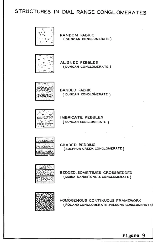
number of bands of congloverate derived from the Rocky Cape Group and iron ore bodies to the vest. The conglomerate is badly sorted uith fabrics ranging from discontinuous frame-work and pebbles oriented at random to banded or bedded deposits with size sorting and oriented pebbles. The
18
"stems" of the fans lie just east of these peaks, and the conglomerate fans out and decreases in thickness rsestwards from the centres. Observed imbricate structure indicates
currents in the fans travelled southwards on reaching the
piedmont.
On the western and southern sides of the Dial Range the Duncan Conglomerate appears to interfinger with the well-bedded sandstones and shales of the Moina Sandstone. Upper members of this formation overlie the Duncan
Conglomerate. The Yoina sandstone contains wormcasts and "painted" markings due to burrowing organisms and near
Eugenana gastropods are found close to the base of the
formation with a rich trilobite fauna near the top. In
the Dial Range the material appears to have been largely derived from reworking of Duncan Conglomerate but outside this region the sandstones were derived from other local
sources.
19
(1958) is not sumported.
Excepting the unconformity at the top of the Gnomon
rUdstohe on the Gnomon which may be a local discordance
due to landsliding, the only significant tectonic activity
during the Ordovician and Lower Devonian is the widespread
regional subsidence represented by the marine transgression
of the reins. Oandstone and Gordon Limestone.
Deposition in the Lower Devonian was terminated by the
Tabberabberan Orogeny which is a major orogenic phase with
effects recorded in Tasmania, Victoria, and southern New
South Wales.
Two principal movement periods are recognised in the
Dial Range area, the Eugonanan rovement and the Loonganan
rovement.
During the Eugenanan Eovement, the rocks of the mantle
were folded in a competent-incompetent fashion. The thick
wedge of Luncan Conglomerate of the Junee Group and the
Barrington Chert of the tundas Group behaved as fairly
rigid units while the mudstones beneath were tightly folded
with formation of slaty cleavage in axial zones. The
bottoms of the thick wedges were surfaces of differential
movement, or decollements, which in places broke through
the competent units as thrusts. The best example is the
Duncan Fault, which follows the Junee-Dundas Group boundary
C V
rises through the succession in the intervening area as a
thrust fault. Similarly the base of the Barrington Chert.
In Sheffield Quadrangle, near Preston, is a, thrust which
to the north disappears along the bedding at the base of
the formation. These decollement movements, ,with
incompetent - folding of mudstones beneath a cover which
"slid about" during folding, are concentrated at the
bottoms of the competent beds in places and at the top of
the Precambrian basenent in others but are not, areally
widespread.
The Eugenanan rovement resulted in broad, open folds
in competent strata or in strata with bedding defined by
alternating layers with great differences in physical
properties. Thus broad, open folds developed in the Noina
Sandstone (sandstone-mudstone alternations) and in the
Forth and Ulverstone Netamorphics (quartzite-schist
alternations). In incompetent strata, such as the Gordon
Limestone of the Junee Group and the mudstones of the
Dundas Group, the fold styles tend to be 'similar' with
slaty. cleavage being well-developed in certain areas. In
zones of intense deformation, at Bugenana, at the Iron
Cliffs, and in the Westbank Chaos, a penetrative schisi.
tosity was formed with transposition of inherited laminae
and formation of augen texture around calcite lenses
Chaos). This schistcsity is Tabberabbcran, not Tyennan, as was found in another place on the Tasmanian Uorth Coast by Burns (1961a).
The Lugenanan deformation formed some special
structures. In the Forthside Antiform Precambrian meta-sediments dipping steeply south were folded together with
a horizontal cover of Junee Group sandstone. The resultant fold form closely approximates a hypothetical example
deduced by Eoss (1962) but with the axial trace sharply deflected at the =conformity due to the change in primary attitude of the foliations. The offset of the axial trace between the two rock groups is an example of the "shifting of crests" predicted by O'briscoll (1962).
In the Westbank Chaos the fold axes form a partial great circle parallel to the foliation. The folds are folded slabs in a mogabreccia with bedding originally disoriented as between slabs, and the girdle results from superposition of the axial plane foliation upon this
heterogenous assemblage.
At Culphur Creek where flat-bedded Junee Group
22
scale puckering of the phyllite bands. The folds
developed in this area have a low plunge in the mantle
and a steep plunge in basement but have parallel axial
planes.
at Eugenana the change from similar folding with an
axial plane schistosity to conjugate-style, flexural
refold-ing of schistosity is ascribed to changes in the physical
conditions of the rock or to a change in the rate of
deformation. As the direction of shortening was horizontal
for the first phase and vertical for some folds formed in
the second phase, changes in the local stress field are
likely to have occurred.
The structures of the Eugonanan Iovement may be assign-
ed to a "primary thrust" regi e (in the sense of Harland 11.
and Bayly, 1958). The only pl ce in which there is any
departure from this is at The Gnomon whore tear faults
formed under "primary wrench" conditions, from which minor
extension is inferred.
The Gnomon Fault is confined to the Ordovician rocks
and does not extend down into the underlying Cambrian.
There is a change in fold style across the fault. An
anticlinal-synclinal fold pair with a thrusted middle limb
occurs south of the fault, but only a broad gentle
anti-cline north of the fault. This change in fold style across
2
3
folding.
Folds of the Eugenanan phase have axial planes near
vertical and no consistent asymmetry. The associnted
faults are low or high angle reverse faults with no regular
direction of throw. Thus while the Isandula Fault upthrows
oast, the fault through the Precambrian north-east of
Spalford upthrows the western side. This agrees with a
study made by Jennings (1950 who found reverse faults of
opposite throw to be genetically cognate. A regular
vorgence implies, in this type of terrain, a consistent
direction of translation of upper beds relative to lower.
There has been no superficial movement of this kind in the
rantle.
The second deformation period has been terned the
Loonganan, the name being taken from a large syncline some
twenty miles south-west of the Dial Range.
Loonganan folds in the Dial tango area are of two
contrasting styles. At Sulphur Creek, Gunns Plains and
Oorth Hatton, the folds are broad, open, oblique
cross-folds, which interact with Eugenanan folds to give domes
and basins of elliptical outline in plan. The compound
folds are non-cylindrical and axial trends cannot be
determined from bedding analysis as claimed by Lindstrom
(1961). There is a probability that some folds have
a‘v
(1950., Early faults behave as long-standing
inhoao-genoities and blocks separated by faults arc refolded
with different wavelengths and styles. An example is the
fault network at the south-western and of Lorymor.
Those largo, open ftlds in flat-lying rocks of the
mantla v . and in areas of flat-lying foliatio in the
base-E0 havo kinematic lag planes near vortical and strikina
near 350. They mould be classified in the terms of
Harland and Bayly (1958) as folds correspondina to a
"secondary thrust" . roalme.
Ar second croup of Loonganan folds Is Characterised by
steep axial plunge. The folds are asymmetrical with.
resemblances to the qoblique-shoar" folds of de Oitter
(1956, p.214) with a single sot of axial surfaces
(knickor-falten) trending southwest. However, in somo zones the
folds arc conjugate (Johnson, 1956) uith another sot of
axial surfaces trending north-uest. The axial surfaces
are oriented regularly without regard to the primary dip
of the foliation or bedding; the axial plane traces run up
and down the limbs of 'earlier folds. In sou° zones the
knick planes are close-spaced, with separations of only a
few pillicetres, and constitute a penetrative foliation at
the mososcopic scale.
There are somo special fold types that belong to this
conglomerate form two sets with intersections near vertical. Uhere thin bands of schist are contained within the
conglomerate the knick planes cross the schist without change in orientation resulting in two divergent sets of contemporaneous lineations. This is a passive refolding of the schist and the folds might be better termed "knick-drags".
In some other areas the line of intersection of knickerfalten
lies in the foliation and only one set of lineations results.
Apparently polyclinal folds of this type superposed on fold-ed terrains may result in.several divergent fold trends as
observed by Hobbs (1962). On a regional scale, the large
swing in trend of the crestal trace of the Lobster Creek
Anticline and Library Syncline may be due to refolding of
this type. For this to have occurred in the Devonian, after deposition of the Duncan Conglomerate implies an active
decollement at the base of the Junee Group on Et Eontgomery which has also been deduced from other evidence.
The folds with steep axial plunge correspond to the "secondary wrench" regime of Harland and Bayly (1958). However, the folds of the "secondary thrust" group are of
the same age. The two groups of folds are contemporaneous,
4t)
correlation between "noveEent plane" or "bun deformation"
and stress field as nada by Ilarland and Dayly is
inapplic-able In the Dial Range.
The Da ttinecatie planes from different regions tend
to intersect near a direction Ob.350. Tho fold azes, utich
In most areas are the 12 ftinenatic axes, lie in a great
circle nornal to this direction. The great circle is
sub-parallel to the axial planes of upright open folds of lou
plunge in areas or flat-lying foliation, and is the plane
dihotirally bisect1n3 the acute angle between tlnictr, planes
in the Goat Island Conglonerate. The direction 0-350 is
the one direction co).,.on to the movenent pictures from
various parts of the region and is interpreted ao the
infinity-fold axis of a radial stress systen.
The Eueenanq Beds are spelean deposits. Although
tightly folded at the base of the deposit, the folds are
soft-sedicentary conpaction folds du to loading. Tectonic
joints and "ductile-shear" folds in parts of the deposit
are of very snail intensity, are restricted to small regions
of the deposit, and are correlated with sinilar deformation
of Tertiary ago itt adjacent root= of the Permian Systep.
The Tabberabbcran Orogeny was therefore concluded by the
tic° of deposition of the LUgenana Dods and occurred in
the Niddle Devonian.
41
of terra rossa; an early boulder bed with terra rossa
matrix; a cavern fill and fissure fillings of exotic
(derived from outside the cave system) sandstone and
mud-stone; and .a late boulder bed with exotic matrix. The
lithological units form a succession consistent with a
normal karst cycle. Minor erosional structures Show the
caves sere formed at the water table. Streams ran along
the cave floor causing scalloping of boulders in its bed,
and karren flutings in the roof and on the 'walls of
fissures indicate that meteoric waters entering from
above.
The cave was not necessarily formed at the ground
surface as such a cycle can occur deep inside a high
mountain range. At the inception of the Tabberabberan
Orogeny the Gordon Limestone was overlain by about 5,000
feet of conformable younger rocks. The existence of a free
water table indiCates an uplift of this order of magnitude,
and the same Order of erosion, had occurred by Upper
Devonian time.
There . are isolated dolerite sills in the Eugenana
area which were intruded at the base of the Permian System
and which indicate that the base of the Permian System at
Eugenana was of the order of 500 feet above the Eugenana
Beds as now exposed. The level of Carboniferous erosion
28
deposits aad a little noro erosion would have recoved
them entirely. 2he preservation of the Eugonana Beds was
accidental which explains why equivalent rocks have not been found elsewhere in Tasuania t although it nay be noted
that a fossil Ituragessa of unknown age occurs at
Railton, five miles south-east of Eugenana t and may be the
,PRITACIA • • • • • • • • • *** • • • • • • 4, la • Or * • 0 * * 29
A2404
1"381)"14. • • • • • • • ••••••••NOMXXCLATURIS AID 8!llb07•11, ••••••••• 32
GPIXIIAL
owqrvolit
re0eat On • • • • * • • • It • • • • • • • MDTPIVI1017 • • * • • • • •Ilk
Davolopaiort • • .
Outcrop Di stribution• .. • .. IF • •
**** • • • ******* • •
••***** * • • • .• 6.•.• • 0 •
39
OMMAALORMA
Ma Tam= Geosynelina... hO
The Dundas Trough ***** 41
0144 04 uoT4u044u JuTnoT4aud ti4TA UO3! ot/4 Jo AlopTti
3Tuovo4 eq4 OuTuTmoqop 4u pomTu sT u0T4u0T4soAuT 0RX
aomT1 Jo TuA1'o4uT 2uot p uuds
4nq eozu Timms u w ,no. pouTumco S3p0.1 oug 1:104uoseadoz
OV 4VTUVWV1j UT Gaol:I/106p UtIOUI] 1.0U SNOW uuTumaa
zeddn puu'oTozowetud eq4 J0 s4Tun sopam 0qq. 4 upTscimvoeid
eq4 Jo suoTsTaTp zogum et 4 uozu Timms spn ui em2noJz
sepuna oq; Jo 400tis-JJ0 tuz tsT RoW4 M5nosx. °guru
TuTa eq4 uo sozwoo poau e2=151 raTa 0144 Jo SPT14s
opoopsopun AlInj 4ou sT Auo2oao 'croup UT uoT4pmzoJap
jo opn4Tuaam puy em.eu oti4 4aud ;som 01,14 acq 6 soTuo2oao
jo uoTss000ns u palsTIqu4so slag 4 (+66T) oluva Pue Itaxv0
AzrutnoTqxed '2uTddpm opides2T4w4s Ou0144TV *sTsouogolo
uuTuoitoa moij OuTsTau soT4Tzoidmoo Tuan4onz4s puu u0T4u,104Tu
temat44ozPA4 jo osnuOoq dflozo supuna ova Jo oan4ona4s
Tauxo4uT esq4 oulauopp o4 41110 TJJTP oq 04 pmnoj uooct wag 4T
4suo0 von 0ti4 u0 °(296T "ddZ9E "a ° 4d 6 ° T0A 4 uTiv.1 4snV
Jo A4oToos ra0T20T000 0114 JO TVUSTIOr) lieTUMISUI JO A 2OTP0-0
ow," uT posTammuns ozu tram J0 s4insos 0114 4 sammo pup
'uomotog .•N 'etcPdmvo ea 6Aotprze swag ousu .4. Aaaeo ows
twagsvz. Jo 4s.coo
von etp UO oputu trawl GAIN g2nos4ST144 Jo suoT4172TVG4ui *dnoso supuna ueTzcimeo oqz Jo s4uom
-TPas TvuTIouAboogna sur4uo3 goTmn ulsul V 4. 142110JI SVpUna
oti4 uo soawoo uTuumpus, Jo A104spl 0Tozcoutud aqI
iFio Pa- 4."
Dundas Group. A search has been mace for Precambrian
structures which may. have controlled the position or shape of the Dial Range Trough, for structures within the trough that indicate its manner of development, and for structures throughout the area which indicate bow it was deformed.
•The investigation is conducted in two stages. The general structure and stratigraphy of the area is determin-ed by regional mapping at a scale of ftur inches to the mile. Small areas are delimited whicb. yield information of
significance to the tectonic succession, and the second stage of investigation consists of detailed studies of these areas.
In presentation, the area is treated as a whole. Tectonic successions observed in detailed examination of
scattered, small areas are linked together through the
regional mapping and dated stratigraphically where possible.
Chapters
5
to 10 are descriptions of the structures found31
AKLCK/DGT"' I
The regional mapping of the Dial Range area and other parts of Devonport Quadrangle was a continuation of the Regional Mapping Programme of the Geological Survey
Division of the Tasmanian Department of Vines. The support of that organisation with regard to field work ig
acknowledged.
A Research Fellowship granted by General-Eotors-Holden has made possible the detailed mapping of a number of areas
of special interest. I am indebted to Professor S.W.- Carey
of the University of Tasmania for his support and
encourage-ment in this work, and for much stimulating discussion.
Guidance and assistance has been received from Dr. E.
Uilliams, now of the Geological Survey. Dr, A.R. Spry of
the University of Tasmania has taken an active interest in
phases of this work, and has kindly made available much
unpublished material on the Precambrian Metamorphic rocks.
The writer is grateful to Et. M.E. Ranks and Mt. MC,
Solomon, of the University of Tasmania, and Er. T.D. Hughes,
There is no standard work giving a consistent or
comprehensive set of definitions of the terms in frequent
use in Structural Geology. Recent publications show
con-siderable divergence in nomenclature. It is considered to
be desirable, therefore, to make a statement as to the
sense in which some terms are used and to list
frequently-used symbols. As measurements of the axial surface, for
example, will be frequently presented, it is desirable
that the basis on which this measurement is made be
avail-able to the reader. any of the definitions are based
upon unpublished lectures by L.B. Weiss at the Canberra
Symposium on Structural Analysis 1962, and on unpublished
lecture notes of 0.11. Carey.
aztimath is used to mean the true bearing, in degrees
east of geographic north, of a horizontal line or linear
element. Irmil means the azimuth of the normal projection
of a plunging line on a horizontal plane. Thus "the-folds
have a trend 097" means that the normal projection of the
fold axes on a horizontal plane has an azimuth of 097
degrees east of true north.
16-097 means a linear element has a plunge of 16
degrees and an azimuth of 097 degrees.
65S1123 means a planar clement has a strike of 123
JJ
the south-west quadrant. Mere the plane is vertical, as
in "9011270" the "N" is inserted to distinguish between
the figures for strike and the figures for dip and could
equally well have been "8°.
8 is the synbol for a group of penetrative 8-surfaces,
different groups being denoted by 51,82,53,.... Uhere S o
is used it means bedding.
L is the symbol for a group of lineations. Li L2,11,
•....are different groups of lineations. Lo is used for
primary lineations such as flute-casts.
In some areas there is a number of related S-surfaces
of approximately the same age. It is convenient to
designate these 81,18r,So, according to type, and to group
them together as 81.
S1x82: The symbol ex' used in this way means
'intersection'. The exaiple means the direction of the
line of intersection of 8-surfaces of the 81 and 82 classes,
or the lines themselves. In some cases the term L(1,2)
will be used to name lineations to avoid ambiguity and to
avoid repetition of the phrase "a class of lineations
form-ed at the intersection of planes of the classes 8 1 and S2•"
D(81,82) or 3(1,2) moans a class of folds in which the
surface 01 is folded and 82 is generated. S2 is usually,
but not invariable, a structure parallel to the axial
31+
mean that period of folding in which folds of the B(1,2)
class were formed.
The term 'beta is used for a statistically,
projectively defined fold axis.
In relating movement on faults to phases of folding,
use is made of the analyses of Bott (1959), Jaeger (1960)
and Harland and Dayly (1958). The "stress regimes" used
for this correlation are referred to regional axesA03X
whore B is the trend of Eugenanan folds, C is vertical, and
Is horizontal and at right angles to
fl.
(A and B haveazimuths of approximately 080 and 350 respectively).
Fabric axes go b tg are used utters
a
is a prominentfoliation and is a lineation. Xinematic axesga tg are
used viler° b is the axis of external rotation, and the
deformation plane Ag is normal to It. Uhere movement was
by slip on a secondary foliation a is the glide plane.
In order to distinguish between kinematic and fabric axes
the adjectives "fabric" or "kinematic" are used.
Io N ta are used to denote the morphological axes of
"stretched pebbles" at Goat Island. 1,12,n are the lengths
of the axes in individual "pebbles".
"Vergence" means the sense of asymmetry. Thus folds
"verging to the north" means the folds have axial planes
dipping south and related thrust faults dip south (after
JI
"Decollement" is used to mean any flat-lying
detach-ment surface of any size Which occurs within the
sedimentary pile at any level.
"0-surface", after Inopf (1933) is used to mean a penetrative, two-dimensional structure in a rock. "Fold"
is. used,.after Leith (1913, p.105) for that portion of an 0-surface in which one, or both radii of curvature are of finite magnitude and constant sign provided that, after Hall (18)5), the curvature is superimposed. A "cylindrical
fold" is a fold with one radius of curvature infinite. A
."non-cylindrical" or "spherical" fold is one in which portions of an 9-surface have the two principal radii of curvature of finite macnitude. The "axis" of a cylindrical fold is the direction of that line common to all portions of a cylindrically-folded 0-surface. The "hinge" is the region of maximum curvature of a fold.. The "axial surface" is used to mean the surface which passes through all the hinges of a pile of folded 9-surfaces and contains the axis of cylindrical folds. If the hinges are not well-defined, the surface bisecting the limbs is utilised as the axial surface. For non-cylindrical folds, crostal surface and crostal trace are used after Busk (1929, n.8) and Willis
(1893, p.251) but are used for either synclines or
jo
For faults, "slip" is total displacement in the fault
plane in the direction of movement (after Cromtal, 1959).
It is regarded as a line not as a vector. "Throw" and
"shift" are components of slip in planes normal to the
fault - in vertical and horizontal planes respectively.
"Stratigraphic throw" is measured in that plane normal to
the displaced bedding which makes the highest possible
dihedral angle with the plane of the fault.
ismalumulam
XoentlIon:
The Dial Range Area lies between longitudes 146 and
146°20' east, and between 41 and 41°15' south latitude, on the central north coast of Tasmania.
From Bass Strait in the north, the area extends up to
twelve miles inland. From near the Eersey River in the
east, it extends for eighteen miles along the coast to the
west. The area lies in the western half of Devonport
Quadrangle (shown in figure 1).
tbreielo
The Dial Range Arca is that part of the coastal
low-lands of northern Tasmania lying between the Dial Range
and Kelcey Tier. Three topographic units comprise the
greater part of this area - the coastal Larine Platform,
the Lower Coastal Surface, and residuals rising above the
37
figure 2 which was drawn by the writer on the basis of
criteria of Davies (1959).
The Dial Range and Kelcey Tier areresiduals standing
above the Lower Coastal Surface. The north end of the
flange overlooks Penguin, a small coastal township on Bass
Strait. From Penguin the Range, with its companion Mt
Lorymar, runs south west for seven miles, terminating at
the wide limestone valley of Gunns Plain. The summits
lie at a general elevation of 1800 feet, the highest peak
being Mt Duncan at 2200 feet. The Range is bounded on all
sides by an escarpment up to 1500 feet high. The scarp is
covered in thick talus oxcept for occasional lines of
cliffs up to 400 feet high.
Macey Tier is a low, mesa-form residual with summit
levels from 600 to 800 feet high. From close behind
Devonport it runs east of south through Sllias Hill and
Bonneys Tier to the Badger Hills east of Sheffield. The
escarpments are marked by talus and zones of deep
deformational shear slides.
Between Nelcey Tier and the Dial Lange there is a
large tract dominated by the Lower Coastal Surface. This
Is a youthfully dissected, mature, largely erosional
sur-face, rising from an elevation of 300 feet or slightly less
near the coast to about 900 feet ten miles inland. This
AREA COVERED Figure
Locality Map
KING IS.
TASMANIA
0
oft FLINDERS
IS.
100 MLS.
41.
42
43
41*
42*
38
the area under discussion. The surface is exuressed by
laterization of velcanics, extremely deep weathering of
charts and acid lavas, and, in places, as a blanket of
siliceous gravels. The ago of this surface is probably .
Pliocene.
Cut into the seauard edge of the Lower Coastal
Sur-face is a marine platform up to one mile wide, exposed by
Quaternary strand line movemert. The platform fringes the
coast and extends inland as riverine plains. The scarp
between the Lower Coastal Surface and the platform is
mantled with talus Or by zones of mass movement. Into the
Lauer Coastal Surface the rivers have cut meandrine
shaped gorges which become progressively deeper upstream
as the rivers are at or near grade.
, The Narino Platform is a surface of marine erosion
with a thin layer, up to twenty-give feet thick, of beach
shingle, sand dunes, and coastal lagoon deposits. It is
probably Pleistocene in age.
Quaternary uplift has noved the strand line some
miles north of its Pleistocene location, exposing the
deltas, and entrenching the rivers into their
fluvio-glacial gravel trains and into the Marine Platforn.
2002,2nmas
The main townships and the principal highways are
39
secondary highways and townships extend inland along the
Anterfluves, in a ladder pattern. This pattern.is
determined by the geology of the region. An early Tertiary
youthful topography was blanketed with basalt, forming an
extensive lava plain. The modern topography was
super-imposed discordantly, so that Tertiary and modern valleys
rarely coincide. The modern interfluves are, therefore,
frequently the site of Tertiary valleys and are occupied
by basalt, the valleys being cut in older rocks. The
basalt forms the bulk of the arable soil, so that
agricultural development Is largely confined to the modern
interfluves. Along the interfluves run the major highways
to the interior, through agricultural country and numbers
of small townships.
The area is well served by good highways, except the
Dial Range itself where the only access is by foot. The
developed country, in Tertiary basalt, is land cleared of
timber but the Palaeozoic and Precambrian rocks are waste
land carrying a secondary eucalyptus forest with a thick,
scrubby understory of shrubs and bracken or In many places
blackberry vines. The vegetation makes progress difficult
in some areas, and conceals small outcrops.
24010-212Aglati2D1
The distribution of outcrop is directly related to
TOPOGRAPHIC UNITS - DEVONPORT QUADRANGLE
PENIC3 U HIGHER COASTAL SURFACE /,,„„, AND RESIDUAL OUTUERS l'"'"/
11 1 HIGH RESIDUALS
4 MILES
14-0
narrow strip between lou and high tide marks on the emergent marine terrace, but elsewhere the Platform and
the floors of the river valleys are completely concealed
by unconsolidated Quaternary deposits.
The bedrock of the Lower Coastal Gurface is very
deep-ly weathered, as much as ninety feet in some places, and
is covered in many places with a veneer of gravel. In the Cambrian rocks particularly, the bedrock is inaccessible and has to be identified from its weathering products. This is true of highly siliceous rocks, such as charts and lavas, in some areas.
The escarpments between the Earine Platform and the Lower Coastal Surface, and around the residuals, are mantled with talus. Exposures are confined to discontin-uous free faces on the higher parts of the escarpments.
Overall, the amount of rock exposed forms less than one percent of the total area.
TqlMaalleagml=at:
The Palaeozoic rocks in the Dial Range Trough
(defined subsequently) lie in a small part of the Tasmanian Dundas Trough (Banks, 1952) which is itself a small part of the Tasman Geosyncline (Schuchert, 1916).
• The Tasman Geosyncline extends along the eastern sea-