Portrait of the regions: Volume 5 Hungary
180
0
0
Full text
(2)
(3) PORTRAIT OF THE REGIONS VOLUME 5 HUNGARY. Έά. 6UrOStclt. EUROPEAN COMMISSION Statistical Office of the European Communities.
(4) A great deal of additional information on the European Union is available on the Internet. It can be accessed through the Europa server (http://europa.eu.int) Cataloguing data can be found at the end of this publication Luxembourg: Office for Official Publications of the European Communities, 1997 ISBN 92-827-8021-X © European Communities, 1997 Reproduction is authorized, provided the source is acknowledged Printed in Italy.
(5) Foreword The building of Europe is not just the preserve of the Member States of the European Union, but also involves their economic partners, particularly the applicant countries. The trade relations and cooperation programmes conducted between the Union and its neighbours reflect this desire for rapprochement, both between countries and be tween regions. This publication is the fifth volume in the 'Portrait of the Regions' series. After the coun tries of the European Union and those in the European Free Trade Association, it is the first in a series which will be devoted to the applicant countries of central and eastern Europe. As was the case with the previous volumes, its main aim is to give each region the opportunity to find out about its neighbours. Although some of the statistical methods and definitions occasionally differ from those used in the European Union, it still seemed appropriate to extend the field of obser vation to analyse the potential shape of the Union at the beginning of the 21st century. As in the past, the regions are presented in an identical format through the use of maps, diagrams and statistical tables, along with commentaries on their strengths and weaknesses, natural features, population, labour market, economic fabric and the state of the environment. This portrait of the regions of Hungary was a joint venture between Eurostat, the Hungarian Central Statistical Office and the country's regional statistical offices. The work was coordinated on the spot by ECOS-Ouverture, a cooperation programme lin king the regions and cities of eastern and western Europe. My heartfelt thanks go to all those who have made such a valuable contribution to this publication.. Y. Franchet Director-General of Eurostat. eurostat. PORTRAIT OF THE REGIONS.
(6)
(7) The PORTRAIT OF THE REGIONS consists of five volumes: Volume 1. Germany Benelux Denmark. Volume 2. France United Kingdom Ireland. Volume 3. Volume 4. Volume 5. ^2. eurostat. Portugal Spain Italy Greece Austria Finland Sweden Iceland Liechtenstein Norway Switzerland. Hungary. Table of contents. Volume 5. HUNGARY. 1. Budapest. 2. Bács-Kiskun. 10. Baranya. 18. Békés. 26. Borsod-Abaúj-Zemplén. 34. Csongrád. 42. Fej ér. 50. Gyò'r-Moson-Sopron. 58. Hajdú-Bihar. 66. Heves. 74. Jász-Nagykun-Szolnok. 82. Komárom-Esztergom. 90. Nógrád. 98. Pest. 106. Somogy. 114. Szabolcs-Szatmár-Bereg. 122. Tolna. 130. Vas. 138. Veszprém. 146. Zalá. 154. Explanatory notes. 162. Bibliography. 164. Legend to maps. 165. Symbols and abbreviations. 165. PORTRAIT OF THE REGIONS. VII.
(8)
(9) HUNGARY. Hungary, a country of 93 000 square kilo metres and 10 million people, celebrated in 1996 the 1 100th anniversary of its foundation. Owing to its central location on the Danube in the Karpathian Basin, Hungary forms an important link in Europe between east and west and between north and south. Its main geographic regions are Transdanubia to the west of the Danube; the Great Plain east of the Danube; and the mountainous area in the north.. The origin of the county system dates back to the 11th century. Before the First World War there were more than 70 counties, but two thirds of Hungary's land area was annexed to neighbouring countries in the peace treaties that followed the war. The borders of the present counties were fixed during the administrative reform that followed the 1949 Constitution, when the number of counties was reduced from 25 to 19.. The Hungarian Republic consists of the capital, Budapest and 19 counties with 3 125 municipalities (205 towns and 2 920 villages). The capital and its districts, the towns and the villages each have their independent local governing bodies. Regional governments operate at the county level.. The local and county governing bodies are independent; there is no hierarchical relationship between them. Their rights as well as their respective responsibilities are set out in the Self Government Act. The county capitals and towns with more than 50 000 inhabitants can become towns with county rights, which means that they have county-level responsibilities in the provision of some services to the population. There are no macro and micro regional levels of administration in Hungary, but statistical regions are used at both levels for regional analysis purposes.. eurostat. PORTRAIT OF THE REGIONS. Regional differences in Hungary are characterized by the overwhelming dominance of the capital, Budapest - a metropolis where almost one fifth of the country's population lives - and by the rapid development of the western parts of the country as opposed to the more or less stagnating east. These differences have increased since the process of transition to a market economy started in 1989, after four decades of the centrally planned and ruled economy. This transition is still underway; Hungary is a rapidly changing country both in terms of its economy and its society..
(10) BUDAPEST A metropolis on the Danube Budapest, the capital of Hungary is situated on both banks of the Danube, at the foot of the Buda hills, where the plains and the hills meet. Thanks to its excellent geographical situation, human settlements existed in this region as back as the Palaeolithic Period. After the Celtic era, the Romans established a flourishing garrison here. The Magyars appeared here in about 900 AD though their settlements were ravaged by the Mongol invasion in 1241. The rebuilt city, with the Castle of Buda, became a European centre of classical culture at that time, then in 1541 Buda came under the rule of the Ottoman Turks. The 19th century saw the country's largescale industrialization and in 1872 the three independent boroughs of Pest, Buda and Obuda, were unified as Budapest. Budapest developed into the present day metropolis in the second half of the 19th century. In the 20th century, due in part to rapid industrialization and the longterm agrarian crisis, to the capital's favourable location with good communications, and also to the desire to reinforce the separation from Vienna, it became the centre of the Austro Hungarian Monarchy. Budapest became the industrial, trade, political and cultural centre of the country, and its overwhelming dominance was enhanced by the redrawing of the national boundaries after the First World War, when the other major cities in the area, which could have had a balancing effect, were allocated to the neighbouring countries. A new era began in the city's history in 1950 when by annexing 23 of the surrounding settlements, Greater Budapest was formed. This increased the capital's size to twoandahalf times its former area, while its population increased by 50%. Currently, Budapest is administered by 23 district governments and the Budapest City Government which has jurisdiction over the whole area.. View of Buda Castle with the Buda Hills in the background. Budapest. 200. 150 Hungary =100. 50. >. ;. Τ /. / <*. / ,. / ,. χ. /. A varied landscape Budapest occupies a land area of 525 km 2 , a mere 0.6 % of the country's territory. It is sur rounded by the county of Pest, a considerable part of which is covered by the builtup area which extends out from Budapest. The city's extent measures 25 km from north to south and 29 km from east to west. Its lowest point is the water level of the Danube (96 m), while its highest is the peak of János Hill (529 m). Buda pest's relief is highly varied: the eastern side of the Danube (Pest) is essentially flat, while the western side (Buda) is hilly. The Buda Hills, which stretch into the city, are covered with forests. Probably the best panorama of the Hungarian capital is from its natural observation tower, the top of the Geliert Hill, which is situated in the centre of the city's residential district. The famous towers, the larger buildings, the avenues, the ring roads and boulevards, and the bridges spanning the Danube are all clearly visible from here.. PORTRAIT OF THE REGIONS. eurostat.
(11) BUDAPEST «. .,...„. •. Leányfaiu. SZfiNTENDRE · Ρ. W h i c h EU regions a r e similar to Budapest?. O. PomáZ Pom. /. ι Budakalász. i. Csobánka.. Pilisvörösvar PilisszentivÄ 1^^ φ. Szigetmonostor. · Pilisborosjenö. ·. Population density: 3 6004 000 inhabitants per km2 Wien (A) Berlin (D). ·. O. DUNAKESZI o Fot. Nagyki. I. ► Mogyoród. Λ ? Kerepes Csomor r •. Age structure: 3 1 % under 25 16% over 65 Liège; WestVlaanderen (B). Kistaresa f. Nagy tares a. Budakeszi Pécel Maglód. BUDAÖRS C Törökbalint. Tárnok _. 9. J. Gyömro o. Halásztelek. Q. ERD. ·. Employment structure: 7074% in services 26% in industry Région Wallonne (B) Hampshire, Isle of Wight; Kent (UK). Ullo. SZENTMIKLOS Ρ l_V^. G y á |. <©> Dunaharaszti m Szigethalom _ , Alsónémedi • Taksony ψSzazhalombattao _ β ^ ^ ^ « % Tököl. v*, t. 20 km. The central role of water in the city's life The Danube, Central Europe's largest river, crosses the city roughly in a north south direction, thus separating the hills from the plain. The main branch of the Danube in Budapest is about 30 km long, with an average width of 400 m. The river plays a variety of roles in the city's life, the most important being as a source of drinking water. Besides making passenger and goods transport possible between the eight countries through which the Danube flows, the river, together with the islands and the river banks flanked with greenery, provides numerous recreational opportuni ties for the city's inhabitants. Area km2 Budapest Hungary. 525 93 030. 1000 1995 1 930 10 246. Within Budapest's administrative area there are many thermal and medicinal springs each with different levels of water discharge and temperatures. In 1934 Budapest won the title of Spa City, and was declared an international health spa centre by the First International Bathing Congress in 1937. Currently, there are about 80 known thermal and medicinal springs in Budapest with water tem peratures varying between 24 and 78°C. The Buda hills are poor in minerals; only the limestone and sand reserves are worth a mention. lnhab./km2 1995 3 675 110. Population Change (%) 198089 199094 2.1 4.3 3.1 1.2. Budapest Hungary. eurostat. PORTRAIT OF THE REGIONS. Activity 1990 55.1 54.9. Employment % Ag ricult. % Industry % Services Dec. 1994 1990 1990 1990 60.7 5.7 3.0 36.3 11.2 15.4 38.1 46.5. 1995 53.0 48.2. Dec. 1995 6.3 12.0. %. Unempl.. %. 1995 0.7 8.1. 1995 25.9 33.1. 1995 73.4 58.8.
(12) BUDAPEST. One in five of the Hungarian population lives in Budapest Nearly 20% of the Hungarian population lives in Budapest - a total of 1 930 000 people. The population density of the city is 3 675 people per km2 though the density in the various districts of the city varies widely, between 1 300 and 39 000. The role of the capital in the country's settlement pattern is reflected by the fact that the second biggest city in Hungary has a population of just 217 000, and there are only seven other cities with more than 100 000 inhabitants. Migration always played a key role in the growth of the capital's population. In the last third of the 19th century the number of inhabitants grew dramatically, a trend which continued until the 1960s, although from the 1950s onwards the only source of population growth was inward migration. This migration always tended to be sufficient to counterbalance the natural. Population (1 000). decreases in population and even to lead to a slight increase. During the 1980s, however, the situation was reversed and the population continued to fall in the 1990s at an average annual rate of 17 000. This high rate was caused by the consistently high mortality rates and a significant drop in birth rates. Budapest's population is ageing. At the beginning of 1995, 15% of the population were below 15 years old, while 22% were above 59. This means that there are 40% more elderly people in Budapest than children. Despite the positive develop ments in the last few years both in Budapest and the country as a whole, life expectancy remains much lower than in West European countries. Thus, in 1994 the life expectancy at birth of Budapest men and women was 66.8 and 74.1 years, respectively. The rate of infant mortality. Resident population of foreign nationality — 1 9 9 4. 2 500 Total 2 000. Total 46 712 Romania 20 693 Former Soviet Union 4 905 China 2 990 Former Yugoslavia 2 336. 1500. 1000 500. % of total population 2.42 1.07 0.25 0.15 0.12. has decreased significantly when com pared with the high levels of the past, but compared with the other European capitals, Budapest's achievements are rather modest. A large number of foreign citizens live in Budapest - about 47 000 people. A third of all foreigners with residence permits staying in Hungary for a period of longer than a year live in Budapest.. Populé ition by age — 1995 M+F 1 000. M+F %. %. %. < 15. 297. 15.4. 17.2. 13.8. 15-24. 305. 15.8. 17.1. 14.7. 25-39. 363. 18.8. 19.6. 18.1. 40-54. 445. 23.1. 23.2. 22.8. 55-64. 204. 10.6. 10.0. 11.2. > 65. 316. 16.4. 12.8. 19.4. 1 930. 100.0. 100.0. 100.0. Total. F. Demographic account - -1980-90 (1 000). <25 Population 1.1.1980. 1949. M. 1960. 1970. 1980. 1990 95. Far higher than average earnings from employment Budapest has the highest average monthly earnings in Hungary and although the nominal value of wages and salaries rose dramatically in the 1990s, these increases did not keep pace with the rate of inflation and thus real earnings fell. There have always been significant differences in earnings between the various sectors of the economy, and these have remained fairly stable in the 1990s. The gross average monthly salaries of those employed in the financial sector are by far the highest at almost twice the Budapest average salary. Above-average salaries are also recorded in commerce, real estate and some other service sector activities. The lowest earnings are recorded in health care, education and the building industry, at only about four fifths of the average.. 2 059. Births. 208. Deaths. 306. Net migration. +56. Population 1.1.1990. 2 017. There has been little change in the last few years in the differences in the earnings of blue and white-collar workers; the latter earn on average 80% more than bluecollar workers. The advantage Budapest residents appear to enjoy in terms of average gross monthly earnings is less significant when one considers the supplementary incomes and other resources to which provincial residents have access. Thus, while the average gross income in Budapest from full-time and part-time employment combined exceeded the national average income by almost 40%, taking into account the other income to which provincial dwellers have access and the tax which Budapest residents have to pay, the difference dwindles to just 16%.. Close to a third of the average per capita household expenditure in Budapest is spent on food, 14% on transport and communications, and 13% on household maintenance. These proportions are essentially the same as the national average. However, as in many large cities, there are much greater than average income differences between the different social groups, with a considerable element of the extremely well off, and great masses of impoverished people. Parallel with these socio-economic processes, a higher than ever crime rate also characterizes the city. PORTRAIT OF THE REGIONS. =zz. eurostat.
(13) BUDAPEST. Main enterprises. Gross valueadded by sector — 1994 (%) 60. Name. Activity. MOL Rt. Crude oli and natural gas. Tungsram Rt. Lighting. Richter Gedeon Rt. Pharmaceuticals and medicines. Ikarus Jármü Rt. Buses and bus fixtures. Chinoin Gyógyszer Rt. Pharmaceuticals and medicines. MMG Automatika Mü'vek Rt. Industrial process control equipment. Ganz Ansaldo Villamossági Rt. Electrical and railway equipment. Csepeli Fémmû' Rt. Copper and bronze. Taurus Kft. Lorry tyres. 50. Budapest Hungary. 40. 30. 20. 10. ri Energy. Agriculture. Manufacturing. Building and construction. Market services. Nonmarket services. A further strengthening of the services sector Budapest is the economic centre of the country. All branches of its economy, except agriculture, have national signifi cance. Its leading role had already been established in the 18th century, and has strengthened particularly since the last third of the 19th century. A fundamental transformation in the economic structure began in the 1990s. As Hungary's economic centre, Budapest is at the cutting edge of this process. The changes in the branch structure of the economy are characterized by the decreasing importance of the producing branches (especially industry and the building industry) in favour of services. In 1990, a little more than one third of active earners were employed in industry and the building industry, 15% in commerce, and 10% in transport, post, and telecommu nications. Between 1990 and 1995, employment in industry and the building industry, fell by more than 50%, em ployment in commerce by than 50%, and employment in transport by 30%. The city's economic development is enhanced by the creation and develop. ment of the various financial institutions; the extension and development of office space and facilities for the mushrooming business sector; and by the investments in the hotel industry catering for the increasing tourist and business executive demand. The tourist industry occupies a very important position in the Budapest economy. Its hotels and other accommodation facilities receive a third of all guests requiring accommodation in Hungary, and half of all such foreign citizens. Apart from the multitude of monuments, the scenery, and the medicinal and thermal waters, many visitors are drawn to Budapest by the cultural programmes, the national and international conferences, and the increasingly vibrant business activity. Between 1990 and 1995, the transforma tion of the economy gave rise to a two andahalffold increase in the number of registered businesses in Budapest. More than one third of all newlyestablished businesses in Hungary had their head quarters in Budapest. The role of foreign capital is becoming increasingly important; for example, every fourth limited liability. company was established with foreign participation. Thus, 60% of the foreign direct investment that flowed into Hungary went to Budapest. The number of busi nesses with foreign interests increased 12 fold between 1990 and 1993, and the average capital share of the foreign partners in these companies was 57%.. Agriculture — 1 9 9 4 The data for Budapest are included in the figures for the county of Pest.. Gross per capita household income — 1 9 9 3 (%). Wages (national level = 100). Wages and salaries Income from self employment. Hungary Budapest. Sales of agricultural products Social security payments Other 100 1988. 89. 90. 91. 92. 93. β PORTRAIT OF THE REGIONS eurostat. 94. 10. 20. 30. 40. 50. 60. 70.
(14) BUDAPEST. Employment (1 000). Employment — 1990 (1 000). Employment structure (%) 80. Resident employment. 918.3. + Non-residents having a job in Budapest. 196.4. Industry. - Residents having a job outside Budapest = Internal employment. 26.8 1 087.9. Agriculture 1949. 1960. 1970. 1980. 1990 95. 1949. 1960. 1970. 1980. 1990 95. The changing structure of employment During the 1950s, due to large-scale migration to the city and an increase in the female participation rate, there was a significant growth in the number of active earners and in their proportion of the population. This process slowed in the 1960s, while after 1970 there was a turnaround and the number of active earners began to decrease until in 1990 a lower proportion of the population were active earners than in 1949. While in 1949 dependants constituted the majority of the economically non-active population, by 1990 the proportion of inactive earners (those receiving pensions, child allow ances, investment income, etc.) sur passed that of dependants. The branch structure of employment also went through significant changes. There. were considerable increases in employ ment in the 1950s and 1960s in industry and construction, and the weight of these branches in employment rose dramatically. The importance of industry in employment began to decrease after 1970, and since that time an increasing proportion of workers are employed in the services sector. The staff cuts that began in the 1970s affected primarily blue-collar workers, and by 1990 the majority of active earners were white-collar. The 1980s saw the beginning of an increase in the proportion of the self-employed within the work-force. In 1949, these accounted for 13% of the active earners, in 1980 the proportion was 2%, but by 1990 the figure had reached 6%.. In 1995, the city counted 802 000 active earners, 52.5% of them males. A mere 0.7% of employment was accounted for by agriculture, 26% by the secondary sector, and almost three quarters by services. Wage and salary earners made up four fifths of active earners. The level of education of active earners has increased significantly. In 1980 tertiary graduates made up 16% of active earners, but by 1990, this had jumped to 21%. The improvement was particularly noticeable among women.. Characteristics of resident employment —1995 (%) <25 years. 25-54 years. >55 years. Employees. Employees: part-time. Men. 10. 80. 10. 78. 4. Women. 12. 82. 6. 89. 9. Total. 11. 81. 8. 83. 6. A quarter of all industrial production Industry always played an important role in the development of Budapest. For de cades the rate of industrial development in the capital always surpassed that of the provinces and, consequently, a larger and larger proportion of the nation's industry came to be concentrated in Budapest. The industrial significance of the capital began gradually to decrease in the 1960s, but it remained the country's industrial centre. A quarter of all industrial production and three tenths of industrial exports are accounted for by Budapest-based in dustry.. The structural change in the economy affected primarily large-scale industry. The loss of the Eastern markets led either to the disappearance or the splitting-up of many of the large and prestigious socialist enterprises such as the Ganz Mávag Engine and Machine Factory, the Hungarian Ship and Crane Factory and the Lang Machine Factory. In 1995, more than 95% of Budapest-based companies had 10 or fewer employees, while the proportion of those employing over 300 was less than 1%.. Budapest has since 1985 hosted the Budapest International Trade Fair, displaying mostly the latest industrial products. In the last few years, the city has been organizing more and more specialist international fairs as well.. PORTRAIT OF THE REGIONS. ^2. eurostat.
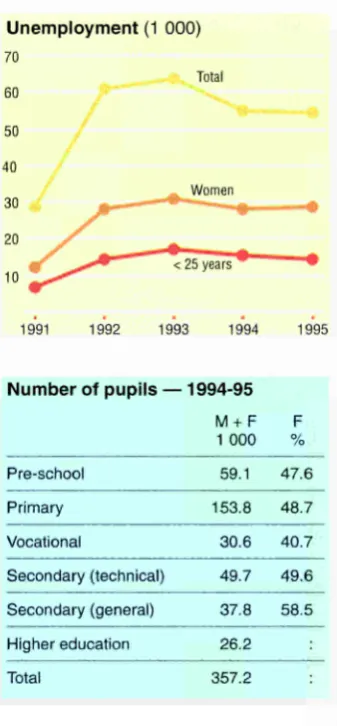
(15) BUDAPEST. The majority of the unemployed are female With the beginning of the structural transformation of the economy in the early 1990s, the formerly disguised unemploy ment became more and more visible. Unemployment rose sharply. At the end of 1990, there were 3 000 registered unemployed; by September 1993 this figure had risen to 71 000. Since then a steady decrease has been recorded, and in September 1995, 56 000 people were officially unemployed. The structure of Budapest's economy ser ved to mitigate the level of unemployment. The concentration of services in Budapest and the continuing strengthening of this sector served to soak up excess labour. An increasing proportion of new jobs were provided by the newly formed companies and small businesses. Consequently, the rate of unemployment in Budapest has always been significantly lower than the national average. Thus, in September 1991 just 1.6% of Budapest's active. earners were unemployed against 6 . 1 % nationally and by September 1995, the Budapest figure was 5.9% compared with 10.3% nationally. This relatively favourable situation is also explained by the fact that redundancies at Budapest-based enter prises impacted significantly on those who commuted and were not Budapest resi dents. There has also been a change in the composition of the unemployed. At the beginning of the 1990s, the majority of the unemployed were male, and blue-collar workers. Subsequently, however, this began to change, and by August 1995 females were in the majority (52%). Bluecollar workers continue to account for the majority of the unemployed with a proportion of almost two thirds. Those with secondary education constitu ted over 60% of the unemployed in August 1995. At the same time, 30% of the unem-. ployed had only primary education and 5% had tertiary qualifications. Of those seeking manual jobs in 1995, 42% had some kind of trade, 34% were semi-skilled workers and 24% were unskilled labourers. There has been an increase in the proportion of semi-skilled workers in the last few years, but a decrease in those of skilled workers and unskilled labourers.. Unemployment (1 000) 70 Total. 60 50 40. Women. 30. Education and health-care facilities of national importance. 20. Budapest's schools and colleges have always attracted students from all parts of the country, as well as from abroad. There are 400 primary schools, over 200 secon dary schools and 42 tertiary education institutions in the capital. Over two fifths of the nation's tertiary students study in Budapest but, owing to their specialist orientation, some of the secondary schools also play a national role.. 10. There are a number of world famous libraries in Budapest with some unique collections. Amongst these is the National Széchenyi Library in whose archives are found handwritten books and other artefacts from the time before printing was invented. Some of these are the oldest texts in the Hungarian language and date from the 12th century, and the collection includes 35 Corvinus codices from King Matthias' library. The Ervin Szabó Library. network plays an important role in the education of Budapest's population and with the sharp rises in book prices in the last few years, demand for its books and services has increased significantly. Budapest is also in a pre-eminent position in terms of health- and hospital care. The almost 12 000 doctors working in the capital constitute over one third of all doctors working in Hungary, while the 30 000 hospital beds account for 30% of the national total.. 1991. 1992. 1993. 1994. 1995. Number of pupils — -1994-95 M+ F 1 000. %. 59.1. 47.6. 153.8. 48.7. Vocational. 30.6. 40.7. Secondary (technical). 49.7. 49.6. Secondary (general). 37.8. 58.5. Higher education. 26.2. Pre-school Primary. Total. F. 357.2. A variety of recreational and cultural activities Budapest boasts about 90 museums which house the most valuable relics and exhibits of the history and folklore of the Hungarian people, fine arts, handicrafts and industrial arts and the works of many foreign painters and sculptors. Some of these museums are in the grandest buildings that adorn the city, such as, for example, the Hungarian National Museum, the Budapest Historical Museum, and the Hungarian National Gallery.. eurostat. PORTRAIT OF THE REGIONS. Over half of the county's theatres are in the capital. Of the musical theatres, the significance of Miklós Ybl's architectural masterpiece, the Hungarian State Opera House, is considerable. In 1984, to mark the 100th anniversary of its completion, the building was fully renovated. Amongst Budapest's other cultural institutions is the Academy of Music, whose first president was Ferenc Liszt himself. The 'Pesti Vigadó' and the Budapest Congress Centre, on the. other hand, offer different but elegant environments for a range of gala pro grammes and chamber performances. The annual Budapest Spring Festival has become a tradition and attracts many visitors from all parts of the world..
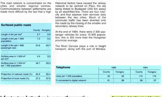
(16) BUDAPEST. The hub of Hungary's transport system Budapest is the centre of the country's transport system. It is from here that the rail and road networks branch out, linking the counties and Europe's larger cities to Budapest, and also linking the western and eastern, as well as the northern and southern parts of Hungary. This situation has its roots in the past, as all other important transport routes were closed, and transport centres were isolated from the country after the territorial changes following the First World War. The transport connections between Buda and Pest are provided by the northern and. Surfaced public roads Budapest Hungary Length in km per km 2. 5.5. 0.6. Length in km per 1 000 population. 1.5. 5.2. Length in km per 1 000 passenger cars. 5.2. 24.7. Surface area in 1 000 m2 per km 2. 35.5. 3.2. Surface area in 1 000 m2 per 1 000 population. 9.7. 29.3. Proportion of national roads (%) Proportion of local roads (%). southern railway links and the seven bridges across the Danube. The city has a total length of more than 4 000 km of roads, providing an urban road density ten times higher than the national average. This network has to satisfy the needs of 2.5 million people, the daytime popula tion of the capital. There are more than 1 100 km of public transport routes. The modern 30km long underground has revolutionized Budapest's public transport, and the 100year old Millennium under ground railway line, which was the first of its kind on the European continent, remains an important factor in the transport system. Commuter traffic is fairly high in Budapest in comparison with other cities of its size. Of the annual 1.5 billion trips made on Budapest's various public transport services, 5% are made on the suburban commuter trains and buses.. completed it will significantly reduce traffic congestion and air pollution over Budapest. There are almost 30 railway stations of various sorts in the capital and the Eastern, Southern and Western Railway Stations link Budapest to the whole of Europe. Although the Ferihegy Airport is among the smaller airports of Europe, it is used by between 20 000 and 25 000 aircraft each year from more than 20 of the world's airlines.. It is not so much an advantage as a great source of problems that all important transport routes, both road and rail, end at, or start from Budapest. The ring road (the M0 motorway) allowing traffic to bypass Budapest is under construction. Once. Telephone 2.7 97.3. 62.4 37.6. 1990 Budapest. Hungary. Budapest. Hungary. 227. 96. 341. 174. 94. 88. 100. 97. Lines per 1 000 population % connected to digital network. Good public utility provision except in outlying districts Budapest's main source of water is the Danube. The chemical content of the Danube's water differs from region to region, but in many areas natural filtration renders the water from the wells on the river bank potable. Public piped water supply in Budapest is almost universally available, with 98% of households enjoying this facility. Uninterrupted water supply is available even at peak times, although the condition of some of the pipes is a source of concern; one tenth of the network was laid in the last century and due to a lack of funds the level of maintenance and reconstruction has not been sufficient. The level of development of the public sewerage network is very uneven; 90% of households are connected, but 80 000 households in the more outlying districts lack this facility, resulting in a major source of environ mental pollution. Household waste is regularly collected in practically the whole of Budapest, but only a half of this waste is appropriately treated.. 1994. The telecommunications network remains probably the weakest link in Hungary's infrastructure, despite the significant development that has taken place in the 1990s.. Connection of dwellings to public water supply and sewerage 1994(%). 100. ■ Water ■ Sewerage 80. 60 40 20. Towns. Villages. PORTRAIT OF THE REGIONS. Total. Wh. eurostat.
(17) BUDAPEST. Struggle against environmental degradation Budapest is fighting against overcongéstion, noise, air pollution, water pollution and mountains of waste, as well as against 'aesthetic' pollution due to uncontrolled construction activities and the lack of adequate building maintenance. The improvement of Budapest's environmental condition has always been an important element in the city's development plans but the funds available for environmental conservation have always been signifi cantly less than required. Consequently, the scarce funds have always had to be concentrated in the areas of greatest need. Water protection received the greatest emphasis in the 1980s, accounting for approximately one third of all environ mental investment. Significant sums were also spent on toxic waste disposal and treatment (18%), and air-quality protection (10%). Consequently, hardly any money was left to tackle noise pollution and vibration or other environmental problems. As a result of the concentration on water. protection, between 1980 and 1994, the length of the city's public sewerage network increased by two-and-a-half times, and for every 1 km of piped water network the city had 900 m of public sewerage. However, in the 1990s, the emphasis was switched from water protection to the decontamination of, and protection against, toxic wastes. Because of the lack of funds Budapest still has significant environmental problems in the areas of air pollution, waste water treatment and waste disposal and decontamination. Air pollution often either approaches or exceeds the acceptable monthly average limits. A significant proportion of waste water is either not treated adequately, or Is allowed to flow into the Danube untreated, while existing facilities for waste disposal and treatment are becoming less and less sufficient.. Environment (1991-94) Budapest Hungary Proportion of total national environmental investment Proportion of environmental investments in total investment. %. %. 10.1. 100.0. 1.4. 4.6. Proportion of environmental expenditure on: Water protection Air protection Waste management. 50.8. 38.3. 9.3. 11.1. 19.3. 7.5. The centre of research Hungary is an important contributor to international research and boasts a fine record in research and development in spite of its small population and chronic scarcity of funds. Budapest is the centre of research and development, and the entire gamut of research and development activities is carried out here. The Hungarian Academy of Sciences, with its central organization and most of its research institutes, and the majority of the university and business research units operate in the capital.. search as well. Side by side with the Statefunded research establishments, much research and development activity is funded by private enterprise. In relation to Budapest's weight in the other industrial sectors, its importance in research and development is disproportionately high. More than two fifths of the country's research establishments are located In Budapest, employing 60% of its re searchers and receiving two thirds of the funds devoted to this sector.. The structural change in the economy led to changes in the area of scientific re. Unique qualities with all the problems of a large city Its geographical situation and its townscape rich in architectural features place Budapest amongst the world's most beautiful cities. Its tourist attractions further include the wide variety of its cultural life, with its traditions, medicinal baths, and culinary delights. The city's attributes, together with the relatively developed economic, financial, and scientific sector have made Budapest one of the regional centres of East Central Europe. Budapest's population is gradually ageing - birth rates are low while mortality rates are high; life expectancy is far below that. eurostat. PORTRAIT OF THE REGIONS. of the developed Western countries. At the same time, due to the high concentration of population and economic activity, the city's services and infrastructure are overused, leading to tensions. While the Danube is the source of high-quality drinking water, the lack of adequate public sewerage facilities and the lack of appropriate waste water treatment threatens to contaminate the Danube's catchment area. The road network is fairly dense in Budapest, but the width and quality of the roads have not kept pace with increases in traffic. This increase, together with the ageing vehicle stock, is a major source of air pollution. The com. munications infrastructure has been expanded significantly in the last few years, but much work remains to be done..
(18) BACSKISKUN The largest Hungarian county BácsKiskun has the largest territory of any Hungarian county, occupying two thirds of the region between the Danube and Tisza rivers. For centuries Hungarians have lived peacefully side by side here with Romanians, Germans, southern Slavs, and Slovaks. Significant development took place in this region In the 19th century. It was mostly due to the farreaching changes in transport, such as the extension of the railways, that it was made possible for the region to become more integrated into both national and international commerce. Agriculture was the primary beneficiary of this process, although other sectors were affected as well. At the end of the last century, the small and mediumsized landowners formed such an effective horticultural industry that they were able to ride out the world economic crisis of the time. Not even the decades following the Second World War were able to extinguish the spirit of private enterprise; of the 40 000 farmsteads that existed after the war, more than 30 000 escaped collectivization and still survive today. The county's present administrative territory was established on 1 January 1950 by amalgamating parts of former counties. At the end of 1994, the county had 14 towns and 103 villages. Kecskemet, the county capital, occupies the largest area (321 km2), while Kalocsa is the smallest town (53 km2). Of the villages, the two extremes are represented by Újtelek (10 km2) and Szabadszállás (165 km2); the latter was declared a town in 1995.. Windblown sand between the Danube and the Tisza rivers BácsKiskun. 200. 150 Hungary =100. t. °. ·. f. ·. f. f. ". ·. 50. / #.# « » >. *. .*<<■. i #. i S i * ^ Ac? .'. # >. j&*. / J&. y. A flat but diverse region BácsKiskun covers an area of 8 362 km2, 9% of the country's land, and lies between the rivers Danube and Tisza. The Danube is the western border of the county, while the Tisza forms the eastern border over a 30 km stretch. Bács Kiskun borders six Hungarian counties as well as Yugoslavia. Even though its territory is flat, in terms of relief and other natural features it is still more hetero geneous than other parts of the Great Plain. It can be divided into three regions: the plain by the Danube, the sand tableland between the Danube and the Tisza, and the Bácska loess tableland in the southwest. BácsKiskun's weather is determined partly by its continental climate and partly by the county's geographical characteristics. A significant part of the county has over 2 000 hours of sunshine annually. Temperature variations are large in the sandy regions, with relatively low air pressure both in winter and in summer, often resulting in stormy winds.. 10. PORTRAIT OF THE REGIONS. WL. eurostat.
(19) BACS-KISKUN. Poor water resources The region's geological structure offers potential for the development of hydrocar bon and geothermal energy. Drilling for hydrocarbons began a few decades ago but led mostly to the discovery of thermal waters. However, significant deposits were discovered in the central and south eastern part of the county (in the SzankZsana-Kiskunhalas region) whose exploi tation increased the county's role in Hungary's crude oil and natural gas pro duction. The only other raw materials are clay and gravel, which are used in the con struction industry. There are great variations in the incidence of thermal waters in the county, with the middle and eastern parts having the best supplies. Thus, for example, in the Tiszakécske area, the temperatures in the thermal wells are above 75°C, while in other parts of the county, the temperatures are only about 35-50°C. Thermal waters are utilized mainly in public baths, but also in agriculture in some areas. Bács-Kiskun's central areas have quite poor water reserves and it is only on its borders that the rivers Danube and Tisza assure a good supply. On the alluvial plains of these rivers, alkaline lakes and other seasonal lakes are common. Many of them are quite shallow, and in prolonged dry spells they dry up, leaving natron visi ble in the silt.. Which EU regions are sim ilar to Bács-Kiskun? Land use: 15-17% forest 70% agriculture Poitou-Charentes; Picardie (F) Scotland (UK) Employment structure: 54% in services Area km2 Bajai Bácsalmási Kalocsai Kecskeméti Kiskó'rösi Kiskunfélegyházai Kiskunhalasi Kiskunmajsai Kunszentmiklósi Jánoshalmai Bács-Kiskun Hungary. 1 133 381 1 171 1 572 873 811 970 392 661 399 8 362 93 030. 1 000 1995 78 19 65 168 50 53 50 17 23 18 541 10 246. 30-32% in industry 14-15% in agriculture Castilla-La Mancha (E) Age structure: 34% under 25 15% over 65 Leicestershire, Northamptonshire (UK). lnhab./km2 1995 69 49 56 107 57 65 51 44 35 46 65 110. Population Change (%) 1990-94 1980-89 -2.6 -1.0 -12.3 -4.0 -8.6 -1.6 1.5 1.4 -6.7 -1.0 -4.6 -2.3 -5.2 -0.9 -13.9 -0.8 -3.4 -0.5 -13.5 -3.0 -4.2 -0.6 -1.2 -3.1. Bács-Kiskun Hungary. eurostat. PORTRAIT OF THE REGIONS. Activity. %. Unempl.. %. 1990 53.4 51.1 54.8 58.0 55.0 53.5 55.6 55.7 52.9 49.4 55.1 54.9. Dec.1994 12.7 14.7 10.7 11.1 12.7 10.3 10.7 10.7 17.1 18.7 11.9 11.2. % Agricult. 1990 28.7 46.5 35.8 22.9 47.3 30.7 27.6 47.7 34.8 45.9 31.6 15.4. 1995 46.8 48.2. Dec. 1995 11.7 12.0. 1995 14.5 8.1. Employment % Industry % Services 1990 1990 34.0 37.3 26.0 27.5 36.3 27.9 42.1 34.9 21.4 31.3 34.4 34.8 41.1 31.3 28.3 24.0 27.2 38.0 22.3 31.8 37.4 31.1 38.1 46.5 1995 31.5 33.1. 1995 54.0 58.8. 11.
(20) BÁCSKISKUN. Falling population BácsKiskun has a population of 541 000, and is the fifth most populous county in Hungary. For a long time, however, its population has been decreasing. Since 1960, its population has decreased by over 45 000 people. In the past, population losses were mainly due to migration which, even up to the end of the 1970s, was more or less counterbalanced by natural in creases. Only since 1980, has a natural decrease also contributed to population losses. The birth rates signal unfavourable changes. Minor fluctuations aside, there is a definite decline in the number of births. At the beginning of this century, the birth rate reached almost 40 per 1 000 popula tion which decreased to around 20 by the middle of the century, while today it does not even reach 12. The death rates, on the other hand, have been steadily increasing. since the second half of the 1960s. This is due partly to the ageing of the population, and partly to the fact that there has been a deterioration in the quality of life of various groups. From 11 per 1 000 population in the 1960s, the death rate climbed to above 14 in the early 1980s and in the 1990s has risen beyond 15. Life expectancy among males is below 64 years, while it is a little above 73 for females. BácsKiskun has a higher than average proportion of deaths attributed to violent causes, such as in juries, poisoning, accidents and suicide. The population is ageing both the number and proportion of the oldage population have been increasing. This trend is indica ted by the 'ageing index', which is current ly 105 (for every 100 children under 15, there are 105 people above the age of 60).. The largest ethnic minorities in Bács Kiskun are the Gypsies, and ethnic Germans. Following these are the southern Slavs, Romanians, and Slovaks.. Populé tion. M+F 1 000. M+F %. 15. 101. 15-24 Resident population of foreign nationality — 1 9 9 4. F. M. %. %. 18.6. 19.7. 17.7. 84. 15.5. 16.6. 14.5. 25-39. 109. 20.1. 21.2. 19.1. 40-54. 110. 20.3. 20.8. 19.8. 55-64. 59. 10.9. 10.0. 11.7. > 65. 79. 14.6. 11.6. 17.3. 541. 100.0. 100.0. 100.0. <. Population (1 000). by age — 1995. 600 500. <65 400 300. Total Former Yugoslavia Romania Former Soviet Union Germany. 200. 6 209 2 962 2 086 447 298. % of total population 1.15 0.55 0.39 0.08 0.06. Total. Demographic account 1 9 8 0 9 0 (1 000). <25 100. Population 1.1.1980 1949. 1960. 1970. 1980. 1990 95. Births. 71. Deaths. 82. Net migration. Low incomes but increasing savings Almost 115 000 people are employed by companies with more than 20 people and by public sector organizations, and aver age gross monthly wages and salaries are considerably less than the national aver age. Just over 70% of this income is taken home as net wages. The gross wages of bluecollar workers barely reach two thirds of the county average, while the salaries of whitecollar workers jumped to 3637% above the average in 1994. Earnings are lowest in agriculture and highest in finance. Average monthly earnings in other industries differ little from the county aver age. Males earn 10% above the average, females 10% below.. 12. 569. Population 1.1.1990. 13 545. There are wide differences between the incomes of the different social groups. Despite the low level of wages and sala ries, there is a steady growth of savings deposits. The greatest increases are in hard currency deposits. Forty per cent of net annual per capita income in 1993 in the south Great Plain region (BácsKiskun, Békés, and Csongrád) was spent on food, the largest single category. In addition to this, consi derable sums go on rent and housing expenses and, in the case of active earn ers, on transport. Far behind in order of importance is spending on clothes, luxury goods, household fittings, entertainment, and education.. PORTRAIT OF THE REGIONS. ΞΊΆ. eurostat.
(21) BACS-KISKUN. Main enterprises. Gross value-added by sector — 1 9 9 4 (%) 50. 40. County Hungary. 30. Name. Activity. Univer Szövetkezet. Canned food, spices, and retail. Kunság Volán Rt. Road passenger transport. Petöfi PJyomda- és Csomagolóanyagipari Rt. Printing and pack aging materials. Glória Bútoripari Rt. Wooden and uphol stered furniture. Búzakalász Mezõgazdasági Szóvetkezet. Mixed farming and food processing. Bácsalmási Agráripari Rt. Mixed farming and food processing. Bácska Agráripari Rt. Meat and fish processing. 20 10. Agriculture. Energy. Manufacturing. Building and construction. A diverse economy The development of Bács-Kiskun's eco nomic structure has been significantly influenced by its natural and settlement char-actehstics. Until the mid-1960s the economy was basically agricultural and the food sector has maintained its pre eminent position. The county accounts for a proportion of agricultural production and sales of agricultural products greater than its land area. The region is most suitable for vegetable, fruit and grape growing and accounts for a large proportion of national production in these sectors. The wide range of organizational forms of farming in the 1960s made it possible forthose crops amenable to mechanization and requiring large tracts of plough-land to be produced in large-scale agricultural concerns, while for those crops requiring more specialized attention to be undertaken in the more trad itional confines of the family unit. In the 1960s and 1970s, the backward industrial sector also began to develop quickly in parallel with agriculture. Together, they acted as stimulants to the service sector. Industries associated with crude oil and natural gas production, agri-. cultural and food-processing machinery, telecommunications, vacuum and preci sion engineering and light industries such as textiles, leather and wood-processing all increased in importance. In the 1990s, significant restructuring has taken place in the economy of BácsKiskun together with organizational changes. There has been a growth in the number of private businesses, and a reduction in the number of the very large enterprises.. 100. Agriculture — 1 9 9 4. Wages and salaries. 96. Income from selfemployment. 92. S i n c e 1990, f o r e i g n private capital h a s b e e n e n c o u r a g e d . At the e n d of 1 9 9 0 , t h e r e w e r e only 2 0 1 b u s i n e s s e s with for e i g n capital o p e r a t i n g in the county; this n u m b e r had i n c r e a s e d sixfold by 1994.. There are approximately 50 000 firms in the county, representing 5% of the national total. Eighty per cent of these are small pri vate businesses, and most of these are self-employed tradespeople and shop keepers. The majority of companies employ only a few people; indeed, three quarters of them have 10 or fewer employ ees. Ten per cent of companies belong in the medium category, employing between 21 and 50 people, while the number and proportion of those employing 300 or more is very small.. Gross per capita household i n c o m e — 1993 (%). Wages (national level = 100). Privatization o c c u r r e d first in c o m m e r c e a n d t h e hotel a n d catering industry. B y 1 9 9 4 , almost t h r e e q u a r t e r s of s h o p s w e r e in p r i v a t e h a n d s . In a g r i c u l t u r e , m a n y t h o u s a n d s of p e o p l e h a v e received land through the State compensation programme.. Hungary. Number of holdings. 11 692. Labour force. 28 621. Agricultural area (ha). 591 700. Livestock (LU). 141 544. Gross per capita value of production (Hungary = 100). South Great Plain. 101. Sales of agricultural products. Financial services. 1988. 89. 90. 91. 92. V-* 93. Û PORTRAIT OF THE REGIONS eurostat. 94. Main products by gross value of production:. Social security payments. Pigs. Other 10. 20. 30. 40. 50. 60. 17%. Maize. 8%. Poultry. 7%. 13.
(22) BACS-KISKUN. Employment — 1990 (1 000). Resident employment + Non-residents having a job in the county. 42.3. - Residents having a job outside the county. 42.8. = Internal employment 1949. 1960. 1970. 1980. 1990 95. 1949. 1960. 1970. 1980. 238.5. 238.1. 1990 95. Agriculture is still an important employer With the reduction and ageing of the popu lation in the last few decades there has been a steady deterioration in the eco nomic participation rate. Thus, it has almost reached the situation of the 1930s and 40s when a large proportion of women did not have paying jobs and conse quently were not entitled to pensions. The 1990 census indicates that almost every second county resident was an active earner; 239 000 in total (this number has been steadily decreasing since the 1960s). There has been a change in the employment structure; while agriculture employed almost two thirds of the labour force in 1960, it did not even account for a third at the 1990 census. There has been an increase in the proportion accounted for. by industry and construction, even though there has been a decline in the absolute numbers involved. The service sector has become more important in the last 30 years, employing 37% of the labour force in 1990 as opposed to just 18% in 1960. Further significant changes have also taken place in the area of employment since the early 1990s. The transformation of the old State enterprises, and the emer gence of new companies has been accom panied by the large-scale shedding of labour, which peaked in the first few years of the 1990s. Agriculture was the most hit by this trend - between 1993 and 1994 there was a 22% job loss in this sector, while commerce and repairs and mainte nance lost 10%. By 1994, the rate of job. losses had slowed significantly in BácsKiskun just as it had done nationally. Despite the fact that in the 1990s there has been a small decrease in the number of blue-collar workers and a small increase in white-collar workers, the former still make up the majority of the work-force (around 60%). In 1995, the primary sector employed 14.5% of all active earners, which is still well above the national average. Industry and construction accounted for 31.5%, and the tertiary sector for 54%; both below the national figures.. Characteristics of resident employment — 1995 (%) <25 years. 25-54 years. >55 years. Employees. Employees: part-time. Men. 12. 79. 9. 70. 3. Women. 14. 83. 3. 78. 8. Total. 13. 81. 6. 74. 5. Food industry dominates Bács-Kiskun's industry has traditionally been tied to agricultural production and its processing. It was only in the 1950s and 1960s that important industrial develop ment began to take place here with the settlement of industrial plants from other counties and particularly from Budapest. This development, however, was not able to create sufficient employment, so migra tion began on an increasingly large and prolonged scale, leading to a decrease in the county's population. Industrial develop ment gained greater momentum in the 1960s leading to a jump in industrial pro duction and the numbers working in indus. 14. try. This trend continued into the 1980s; then, following a mild slowdown, a new wave of transformation began with the 1990's. The county's industry has become more independent, with increasing num bers of county-based businesses.. ned vegetables and fruits, wine, shoes, etc. In 1995, close to a third of the value of the county's industrial production was exported.. Food processing has always been the lead ing industrial branch in the county, accounting for over half the value of total production. Light industry (textiles, cloth ing, wood, printing) and the machine indu stry are also important. Some of the coun ty's best-known products are poultry, goose liver, paprika, food seasonings, can PORTRAIT OF THE REGIONS. eurostat.
(23) BACSKISKUN. Bluecollar workers hardest hit by unemployment While for decades full employment was the norm in BácsKiskun, as in the rest of the country, in the course of the farreaching changes in the 1990s (structural change, the advent of private enterprise, and the decline or transformation of the old State enterprises and cooperatives), many peo ple have become unemployed. At the 1990 census, the unemployment rate was barely 3% (6 000 people). It rose sharply until 1993, after which it decreased somewhat; in 1995 just below 26 000 were unemployed. This decrease was not due to an increase in the number of jobs, but to the fact that a lot of the jobless could no longer receive unemployment benefits and were therefore excluded from registration. Considering that there are 2030 unem ployed for every job vacancy, it is most likely that the majority of these will remain unemployed for a long period. Four fifths of the registered unemployed are bluecollar. workers. The young make up 810% of total unemployment. Half of the unemployed were trained as skilled workers or were educated in trade schools. A somewhat smaller proportion have completed secondary school educa tion, while a few have tertiary qualifica tions. Almost half of the unemployed are between 36 and 55 and for these it will become increasingly difficult to obtain a job as they approach retirement age. The four crisis zones in BácsKiskun have for some time been Bácsalmás, Kiskun majsa, Kunszentmiklós, and Tiszakécske and its environs.. Unemployment (1 000) 50 Total 40 30. Women. Six colleges offer tertiary education Tertiary e d u c a t i o n in B á c s K i s k u n is c l o s e ly tied to the county's traditions a n d the c h a r a c t e r of its e c o n o m y but it h a s s e e n s o m e c h a n g e s recently. T h e six c e n t r e s of. tertiary education are concentrated in Kecskemet and Baja. The first two to be established, in 1959, were the Baja Teachers' College and the Kecskemet Training College for Kindergarten Teachers. In the last few years, the latter has been training other teachers as well. In 1964, the College of Automation Technology and Engineering was estab lished in Kecskemet, and students can also study in the Faculty College of the Horticultural University. In Baja, hydrologi cal engineers are trained in the College of Water Management.. of the 1960s. The vocational secondary schools have become increasingly popular as an alternative to the traditional academ icallyoriented secondary schools. Variety and colour are added to education by the institutions specializing in the arts. Thus, singing and music instruction has a preeminent role in Kecskemet, the birth place of Zoltán Kodaly.. The institutional network of secondary education was fully developed by the end. 1991. 1992. 199 3. 1994. 1995. Number of pupils — 199495 M+F 1 000. %. Preschool. 21.4. 48.5. Primary. 53.7. 49.4. Vocational. 10.9. 40.2. Secondary (technical). 8.6. 54.2. Secondary (general). 6.4. 63.3. Higher education. 5.2. Total. F. 106.2. Unique museums The foundations of the county's library net work were laid in the 1950s. By the end of the 1970s, every settlement had a public library, even if there were differences in the levels of service. There are over 200 public libraries in the county and every sixth per son is a member of one of them. There are up to 300 000 visitors a year to the permanent and occasional exhibitions of the county's 45 museums. Apart from the traditional museums of local history and those which feature the lives and works of outstanding personalities, there. ΞΪ. eurostat. PORTRAIT OF THE REGIONS. are a number of other museums in the county that are unique in Europe. Examples are the Prison Museum in Kiskunfélegyháza, the Toy Workshop and Museum, the International Pottery Studio, the Enamel Workshop and the Naive Artists Museum in Kecskemet, the Medical and Medicinal History Museum, the Folk Industrial Arts Museum, and so on.. Millennium (1896) of the Hungarian Conquest. About 500 performances are staged to an annual audience of over 150 000.. Kecskemet houses the county's most important cultural establishment, the József Katona Theatre which took only five years to build on the occasion of the 15.
(24) BACSKISKUN. Increasing transit traffic On account of its central location, a lot of the nation's traffic necessarily crosses the county. The total length of main roads in the county is over 2 000 km in other words, for every 100 km 2 of land area, there are 27 km of main road. Despite the fact that a tremendous amount of work has gone into improving the quality of the roads in the last decade, there has been a deterioration in their condition on account of their intensive use. There is no motorway in the county apart from the 16 km stretch of the M5. Seventy. Surfaced public roads County Hungary Length in km per km. 2. 0.4. 0.6. Length in km per 1 000 population. 6.2. 5.2. Length in km per 1 000 passenger cars. 26.2. 24.7. Surface area in 1 000 m 2 per km2. 2.2. 3.2. Surface area in 1 000 m 2 per 1 000 population. 34.7. 29.3. Proportion of national roads (%) Proportion of local roads (%). two kilometres of the E75 cross the coun ty; this is Hungary's and also western Europe's most important road link with the Balkans. There are a further 31 km of pri mary main roads, and around 500 km of secondary main roads. The length of railways exceeds 600 km and the most important lines in the county are between Budapest and Kelebia (which carries international traffic) and Budapest and Szeged. In addition to the main and secondary lines, there are a number of narrow gauge tracks for 'nostalgia trains' which operate as tourist attractions. The river Danube offers a potential means of transport; this, however, has not yet been exploited. Of the three Danube bridges south of Budapest, two are in BácsKiskun, and both of these are suit able for road and rail traffic. The only air port in the county is a military one; thus there are no facilities for civil aviation.. Telephone 68.9 31.1. 62.4 37.6. The electrification programmes of the past decades means that today every settle ment has electricity; this, however, is not the case for every detached farmstead on account of the high costs of connection.. Hungary. County. Hungary 174 97. Lines per 1 000 population. 67. 96. 129. % connected to digital network. 77. 88. 88. Progress in infrastructure but deficiencies remain A few decades ago, the county's cities and villages were underprovided with public utilities compared with the rest of the coun try. This was particularly true for the scat tered and outlying farmsteads. Subsequent development has not been uniform in the county either. The Bácska region and those adjacent to the Danube have always been better supplied, while the supply in the cities and villages of the sand tableland (Homokhátság) is far from satisfactory most of them lack even basic public utilities.. 1994. 1990 County. Only four cities have district heating and a communal hot water supply network. All settlements have public water supplies but, as with electricity, the detached farm steads are without access to piped water. The 'public utilities scissors' (the length of the sewerage network for every kilometre of piped water network) is less than 250 m. Only one third of the dwellings connected to the public water supply network also have public sewerage. There have been great improvements in the supply of telecommunications facilities over the years. Nine out of 10 telephone lines are connected to the longdistance and international networks.. Connection of dwellings to public water supply and sewerage — 1994 (%) 80 ■ Water Sewerage. 60. 40. 20. Towns. Villages. Total. There were 78 settlements in the county linked to the piped gas network in 1994. In the 10 years to 1994, the number of settle ments connected increased twoandahalf fold, and the length of the network more than fourfold.. 16. PORTRAIT OF THE REGIONS. eurostat.
(25) BACS-KISKUN. The Kiskunság National Park Approximately 20 million m 3 of waste water are drained from the county annually, 40% of this from private households and little more than half of the piped drinking water supplies. Less than a third of the total water used by the population reaches the public drainage system and consequently most of the waste water ends up in the soil. There is regular municipal waste collection in 72 settlements and half of the county's dwellings and second homes are covered by this programme. This propor tion is significantly smaller than the national average, despite the fact that between 1980 and 1995, there was a threefold increase in the number of dwellings covered. The region's most serious environmental problem is the desertification of the sand tableland between the rivers Danube and Tisza. Due to the long-term lack of suffi cient precipitation and to intensive agricul tural use, the level of phreatic waters has declined considerably in the area. The solution of the problem is a concern at central governmental level.. Environment The Kiskunság National Park consists of six separate units. The Kiskunság Puszta is one of Central Europe's largest alkali flats, with unique flora and fauna. The Tös forest has conserved the landscape which probably existed at the time of the Hungarian Conquest, with its river flats, forests, and thick, bushy undergrowth. The ancient juniper grove near Bugac can be visited with guides. The natron lakes around Fülopszállás and Szabadszállás are rather isolated - this area is the bird sanctuary of the National Park. Unique features of the park are the different types of sandhills, the remainders of the sandy Puszta, the fens, marshes and forests. The interests of the economy and of na ture protection are, with some notable exceptions, well balanced.. (1991-94) County Hungary o/ /o. o/ /o. Proportion of total national environmental investment. 3.5. 100.0. Proportion of environmental investments in total investment. 5.3. 4.6. Proportion of environmental expenditure on: 52.4. 38.3. Air protection. 1.3. 11.1. Waste management. 3.3. 7.5. Water protection. Outstanding results in agricultural research The 100-year history of agricultural re search, and the more recent technical, medical, and social research have played an important role in the shaping of BácsKiskun's present profile. It was in the sandy soils around Kecskemet that the newly established Vegetable Research Institute conducted its first tests in the 1940s. Its work has since become interna tionally recognized. The same is true of the work of the Grape Research Institute 7 000 grape hybrids and almost 100 grape species have been developed there and good results have been achieved in the improvement of species and in the devel opment of virus-resistant varieties. The. Kecskemet faculty of the Horticultural University researches into the biological, chemical, technical, and economic as pects of food production and preservation.. search is carried out at the Great Plain Scientific Institute of the Hungarian Academy of Sciences' Centre for Regional Research.. The centre of technical research is the College of Automation and Engineering, but important work is also being conducted by the Hungarian Academy of Sciences' Institute of Astronomy. Highly complex operations are undertaken in the county's hospitals, especially in the area of internal medicine. The Aviation Medical Research Institute is also based here where, amongst other things, astronauts are pre pared and trained. Social-economic re. The central location has benefits, but also brings problems The county has an important place in Hungary's food industry and exports. The flexible structure of its economy has been able to cope with the challenges of the transition period and, consequently, the county has gained more economic inde pendence and has attracted considerable foreign capital. Bács-Kiskun's central geo graphical location, with sound traditions in research and education, should ensure continuing development in the future. On the other hand, there is the ageing of the population, the unfavourable demo graphic balance, and the characteristic settlements structure with a high propor. Έ-ÎL. eurostat. PORTRAIT OF THE REGIONS. tion of people living in detached farm steads where the development of an infra structure is very difficult. The level of domestic and international transit traffic is very high due to the county's central posi tion and the road network is inadequate both in quantitative and qualitative terms.. tage and the varied cultural life and recrea tional opportunities, has the potential to inject new blood into the economy.. One of the region's biggest problems is that of the water supply in the areas on the sand tableland. The desertification of the area threatens the region's traditional agriculture. The tourist industry, based on the unique natural features, on the architectural heri. 17.
(26) BARANYA A county of small villag es The first settlements on the current territory of Baranya were established about 6 000 BC. From this time on it is possible to trace the history of the people living here from archaeological finds. It belonged to the Roman Empire as a part of the autonomous province of Pannonia and the Romans built one of their major roads across the region linking the east and west of the Empire, branching off to the north at Pecs (Sopianae). This road network was one of the major reasons why commerce continued to thrive in this region following the H ungarian Conquest. The famous defeat at Mohács occurred on the territory of Baranya in 1526 and led to the beginning of the 150 year Ottoman rule in H ungary, which has left its mark on numerous settlements in the county. Baranya's settlement structure is characterized by small villages. Sixty per cent of the county's 412 000 population live In the seven cities (Pécs, Komló, Mohács, Pécsvárad, Sásd, Siklós, and Szigetvár), with the remaining 40% in the 295 villages. Close to nine out of ten villages have a population of less than 1 000. From an ethnographic and folk art point of view the Ormánság is a region of special significance, while the Mecsek-Villány wine-growing areas are among H ungary's most important wine regions. The county capital, Pecs, is a university city, and is one of the country's most important educational and cultural centres.. The 15th century castle of Siklós. Baranya. 200. 150 Hungary =100. T T T T. t. τ. τ. 50. y. /. φ. φ. \$-. v>. /. -ς^. <S~. <^. /. φ. φ. A submediterranean climate Baranya is in the southernmost part of the country. Its 4 487 km 2 land area is bordered in the north by Tolna, in the east by the River Danube and by Bács-Kiskun, in the south by Croatia, and in the west by the county of Somogy. Its terrain is varied; the eastern and southern areas are more or less flat and, much like the country as a whole, there are no high mountains. The Mecsek mountain range is located in the centre of the county, dividing it into north and south and is home to the highest peak in Baranya (Zengö, 682 m). The smaller Villány range in the south of the county divides the Dráva Plain in the same way. Owing to the warm and moist air masses coming from the Mediterranean Sea and to the protect ing belt of the Mecsek mountains, the county is under a submediterranean climatic influence this is unique in Hungary. Thus, winters are mild, spring comes early, summers are warm, autumns are long, there is a lot of sunshine and plenty of well-distributed precipitation. The climate is therefore well-suited for agriculture. PORTRAIT OF THE REGIONS. eurostat.
(27) BARANYA. Which EU regions are similar to Baranya? Area: 4 400-4 500 km2 Molise (I) Luxembourg (B) Population: 0.4 million inhabitants Luxembourg (grand-duché) Guadeloupe (F) Mellersta Norrland (S) Employment structure: 58-61% in services 29-31 % in industry 10-11% in agriculture Basse-Normandie (F). Gifts from nature The mountain ranges are rich in energy and mineral resources. To date, 50 indu strially useful rock types have been found. For a century and a half, the most impor tant mineral resource was the Mecsek's black coal, which played a leading role in the county's development. Commercial mining began in the middle of the last century. A more recent, but also important activity is uranium mining. Limestone, the main rock of the region's mountain ranges, is in many places mixed with clay and is used in cement manufacturing. In some areas the limestone is pigmented and may be used as marble; hence the 'Siklós marble', which is well known abroad. The county's streams, but remain the Baranya has. hilly regions have many the most important rivers Danube and the Dráva. no natural lakes, but there. Area km2 Komlói Mohácsi Sásdl Sellyei Siklósi Szigetvári Pécsi Pécsváradl Baranya Hungary. eurostat. 315 853 384 411 624 669 1 023 210. 1 000 1995 43 53 16 14 36 29 209 12. 4 487 93 030. 412 10 246. PORTRAIT OF THE REGIONS. are more and more artificial lakes being formed. The Ortu and Abaliget regions have become important resort areas centred precisely on such artificial lakes. The other lakes are smaller, but are wellstocked with fish. The population's most important source of water is the Danube, but the water supplies from the karst hills are also significant. The county has rich thermal and mineral water resources. Of the thermal springs, probably the best known are the Harkány Thermal Water Wells with their 62°C sulphurous, radioactive waters; the Szigetvár Wells with their waters also at 62°C but iodic and salty; and the Sikonda Wells with their 30-35°C carbonated and mildly radioactive medicinal waters.. Inhab./km2 1995 137 62 43 33 58 43 205 56 92 110. Population Change (%) 1980-89 1990-94 -2.3 -3.3 -7.9 -1.6 -9.3 -0.3 -0.2 -10.5 -5.8 -0.5 0.7 -8.0 -0.1 -2.1 -8.0 -1.9 -3.6 -3.1. Activity. Unempl.. %. %. 1990 53.2 53.3 53.5 52.4 53.2 54.3 53.8 53.4. Dec.1994 13.4 13.6 19.2 25.5 16.8 17.8 9.0 11.9. -1.6 -1.2. 53.6 54.9. Baranya Hungary. 1995 45.3 48.2. 12.3 11.2. Dec. 1995 14.2 12.0. % Agricult. 1990 7.7 30.3 39.8 38.9 22.7 30.8 6.6 18.5. Employment % Industry % Services 1990 1990 56.9 35.4 30.4 39.3 33.2 26.9 27.2 33.9 32.4 44.9 31.2 38.1 40.5 52.9 43.9 37.6. 15.4 15.4. 38.7 38.1. 45.9 46.5. 1995 10.6 8.1. 1995 30.8 33.1. 1995 58.5 58.8. 19.
Figure

Related documents
Eksperimenti su pokazali da je za mutiranu tRNA Trp , koja nosi supstituciju u D-ruci, smanjena točnost procesa translacije na način da su reakcije koje se odvijaju
19% serve a county. Fourteen per cent of the centers provide service for adjoining states in addition to the states in which they are located; usually these adjoining states have
With the variation of pH, Contact time, Biomass concentration and increase in the concentration of the metal ion in the test solution the degree of adsorption
Assessing the Impact of Biodiversity Conservation in the Management of Maize Stalk Borer (Busseola f
Field experiments were conducted at Ebonyi State University Research Farm during 2009 and 2010 farming seasons to evaluate the effect of intercropping maize with
The objective of this study was to evaluate the feasibility and acceptability of decision coaching guided by the Ottawa Family Decision Guide with children and parents
It was decided that with the presence of such significant red flag signs that she should undergo advanced imaging, in this case an MRI, that revealed an underlying malignancy, which
Also, both diabetic groups there were a positive immunoreactivity of the photoreceptor inner segment, and this was also seen among control ani- mals treated with a
