This is a repository copy of Assessment of long-term performance of blue-green infrastructures in the urban catchment.
White Rose Research Online URL for this paper: http://eprints.whiterose.ac.uk/124236/
Version: Accepted Version
Proceedings Paper:
Ahilan, S orcid.org/0000-0003-3887-331X, Guan, M, Sleigh, A et al. (1 more author) (2017) Assessment of long-term performance of blue-green infrastructures in the urban
catchment. In: ICFM7 ABSTRACTS. Seventh International Conference on Flood Management (ICFM7), 05-07 Sep 2017, University of Leeds, UK. , pp. 119-123.
This is an author produced version of a paper presented at the 7th International Conference on Flood Management (ICFM7).
eprints@whiterose.ac.uk https://eprints.whiterose.ac.uk/ Reuse
Items deposited in White Rose Research Online are protected by copyright, with all rights reserved unless indicated otherwise. They may be downloaded and/or printed for private study, or other acts as permitted by national copyright laws. The publisher or other rights holders may allow further reproduction and re-use of the full text version. This is indicated by the licence information on the White Rose Research Online record for the item.
Takedown
If you consider content in White Rose Research Online to be in breach of UK law, please notify us by
Assessment of long-term performance of blue-green
infrastructures in the urban catchment
S. Ahilan
*†
1, M. Guan**, A. Sleigh* and N. Wright***
* water@leeds, School of Civil Engineering, University of Leeds
† College of Engineering, Mathematics and Physical Sciences, University of Exeter ** Department of Geography, Loughborough University
*** School of Engineering and Sustainable Development, De Montfort University
1 Dr Sangaralingam Ahilan, Collge of Engineering, Mathematics and Physical
Sciences, University of Exeter.
Tel. (01392) 723730. E-mail: s.ahilan@exeter.ac.uk
KEYWORDS: Floodplain, Flood attenuation, Long-term peformance, Stormwater pond, Sediment dynamics.
Objectives
The blue-green infrastructure (B-GI) and sustainable draiange systems (SuDS), such as floodplain restoration, stormwater ponds, wetlands and bio-swales are increasingly regarded as an emerging concept for sustainable urban water management in the UK and many other countries. Nonetheless, the adaptation of the B-GI infrastructures has been slow, predominately due to lack of empirical data, evidence and dominant technical uncertainties in its long-term hydrological performance. Thus it is essential to evaluate the long-term performance of the B-GI so as to bridge the gap between hard engineering approaches and natural systems. This study assesses the long-term performance of a floodplain and stormwater pond on flow and suspended sediment dynamics in two urban catchments through detailed hydrological and two-dimensional hydro-morphodynamic modelling.
Data & Methods
To improve downstream fluvial flood resilience in Johnson Creek, the East Lents floodplain on a 0.26 km2 site has been reconfigured to reconnect to the river (Figure 1).
Figure 1 Johnson Creek watershed
In Ouseburn catchment, a number of stormwater ponds are in place to offset
additional runoff from the proposed Newcastle Great Park urban development on the greenfield site within the greenbelt. This study focus on flow and sediment dynamics in Pond 2 (Figure 2).
[image:3.595.144.454.535.737.2]The layer based hydro-morphodynamic model (Guan et al., 2014) has been adopted to evaluate both short and long-term flow and suspended sediment dynamics in the above mentioned blue-green infrastructure. In the long term simulation, 64 historical flow events between 1941 and 2014 are considered for Johnson Creek, whereas 3896 rainfall events between 1982 and 2015 are considered for Ouseburn catchment.
Results & Disscussions
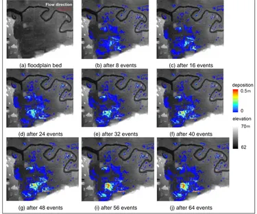
[image:4.595.110.485.293.605.2]Simulation results indicate that East Lents floodplain provides a flood attenuation up to 25% at the downstream and the effects are more pronounced for larger flood event (e.g., 500-year). The temporal and spatial changes of the floodplain topography as a result of cumulative sediment deposition at regular intervals is shown in Figure 3.
Figure 3 Cumulative sediment depositions after 8, 16, 24, 32, 40, 48, 56 and 64 events
As expected, the amount of sediment accumulated in the flood basin gradually increases with subsequent flooding. Results also show that 20% - 30% of suspended sediment from upstream is deposited on the floodplain and consequently reduces the annual sediment loading of Johnson Creek by 1% at the confluence with Willamette river. More details description of the East Lents study can be obtained from (Ahilan et al., 2015).
(a) floodplain bed (b) after 8 events (c) after 16 events
(d) after 24 events (e) after 32 events (f) after 40 events
The stormwater pond attenuates the flood peak by up to 85% at the pond outlet for more frequent smaller flood events (e.g., 5-year). Simulation results indicate that 25% - 60% suspended sediments from the Newcastle Great Park development are deposited in the pond. The flood attenuation and sediment trapping effects by the pond are more pronounced for more frequent smaller and medium flood events. Figure 4 shows the simulated temporal and spatial variation of the sediment deposition in the pond over the 32 year study period (1984-2015).
Figure 4 Cumulative annual sediment deposition from 1984 to 2015
Most of the historical events with small and medium magnitude lead to temporary sediment detention and sediment aggradation in the pond. However there are a few extreme rainfall events in Year 16 (1999), Year 24 (2007), Year 25 (2008) and Year 29 (2012), that resulted in flood events. These events strongly influence the overall sediment budget by flushing out the accumulated sediment as a shock load to the river system. On the one hand, this process considerably reduces the sedimentation,
enabling the pond volume and flood resilience capacity to re-establish. On the other hand, the shock load could lead to elevated concentrations of sediment and pollutants, resulting in dissolved oxygen depressions due to oxidation of contaminants.
Simulation results also indicate that the major proportion of rainfall events cause
(1) year 0 (2) year 1 (3) year 2 (3) Year 3 (4) year 4 (5) year 5
(6) year 6 (7) year 7 (8) year 8 (9) year 9 (10) year 10 (11) year 11
(12) year 12 (13) year 13 (14) year 14 (15) year 15 (16) year 16 (17) year 17
(18) year 18 (19) year 19 (20) year 20 (21) year 21 (22) year 22 (23) year 23
(24) year 24 (25) year 25 (26) year 26 (27) year 27 (28) year 28 (29) year 29
sediment accumulation with an average rate of 0.01 m year-1. It indicates that over time, sediment deposition nonlinearly increases and moves towards the pond outlet direction. According to the model prediction at the end of the 32 years long-term simulation, 993m3 of sediment was deposited in the pond which is equivalent to 18%
of the total sediment input. This resulted in a 12% loss in the pond’s volume which is
equivalent to a sedimentation depth of 0.26m throughout the pond. More details of the Newcastle Great Park study can be obtained from Ahilan et al. ( ).
Conclusions
This study provides the first numerical simulation linking the long-term performance of a floodplain and stormwater pond on sediment trapping and flood resilience. Based on the two case studies undertaken, hydro-morphodynamic modelling and long-term simulation shows that the B-GI offers a considerable means of providing both improved water quality and flood resilience further downstream.
References
Ahilan, S., Guan, M., Sleigh, A., Wright, N. and Chang, H. (2016). The Influence of Floodplain Restoration on Flow and Sediment Dynamics in an Urban River. J Flood Risk Management. doi:10.1111/jfr3.12251.
Ahilan, S., Guan, M., Wright, N., Sleigh, A., Allen, D., Arthur, S. and Haynes, H. (in review). Modelling the long-term performance of a stormwater pond in an urban catchment. Advances in Water Resources.