NOTES ON THE GEOLOGY, GEOMORPHOLOGY AND SOILS OF THE ALGONKIAN
RIVULET-UPPER MAXWELL RIVER AREA, TASMANIAN WILDERNESS WORLD
HERITAGE AREA
by Grant Dixon
(wirh rhree rexr figures)
DIXON, C., 1992 (31 :x): Notes on rhc gcologv, geomorphology and soils of the Algonkian Rivrdcr-uppcr Maxwell River area, Tasmanian Wilderness World l krirage Arca. i'ilp. Proc. R. Soc. l:wn. l 2(i: 13-18. https://doi.org/10.26749/rstpp.126.13 ISSN
0080--4703. 'i4 Marlyn Road, South f !oban, Tasmania, Australia 7004.
Dolomite, probably Prccambri.rn, occurs throughout the Algonkian and !\faxwcll valleys. ! r has been extensively .silicif1ed in .several areas. The dolomite displays only moderate dips and overlies phy!lite and schist, which comprise much of rhe more elevated parts of rhc region. The phyllire and schist were deformed at least once prior to deposition of the dolomite. Karst features occur extensively in the area, bur most are no longer active. There is considerable variarion in soils, from acidic peats ro those associated with alkaline pans. Alkaline pans are common in the area and observations suggesr that, whilst a shorr-term phenomenon, they may be recurring fraturcs of the landscape:.
Key Words: Precambrian dolomite, silicification, karst, alkaline pans, Tasmania.
INTRODUCTION
The Maxwell River and Algonkian Rivuler are pan of rhe Gordon-Franklin river system. They drain a broad valley, remote and difficult of access, west of the Prince of Wales Range. The valley is little known and thickly vegetated, with tall buttongrass heath, closed scrub and forest.
Blake (19 36) noted the presence of dolomites, quanzites and schists in the area, and prepared a rudimentary geological map. Corbett & Brown (] 975) noted the occurrence of "compararively unmetamorphosed Precambrian dolomite" and "pelitic Precambrian metamorphic rocks" in the area, with "undifferentiated Precambrian metamorphic rocks" in the surrounding region.
Can de (1979) explored several of the depressions, lakes and small caves near Algonkian Rivulet.
Recently a number of Aboriginal archaeological sites have been discovered in dolomite caves in the lower Maxwell Valley (Ranson & Harris 1986). These notes document observations made during a survey accompanying, and made possible by, an archaeological reconnaissance of the Algonkian Rivulet-upper Maxwell River area during March 1990.
The landscape is generally low and ourcrop poor. Outcrop is restricted to a few bluffs (commonly concealed in thick vegetation), creek bed exposures and rare flat-lying areas of bare rock (some associated with alkaline pans). However,
the presence of depressions and dolines in many areas is
indicative of underlying dolomite.
GEOLOGY
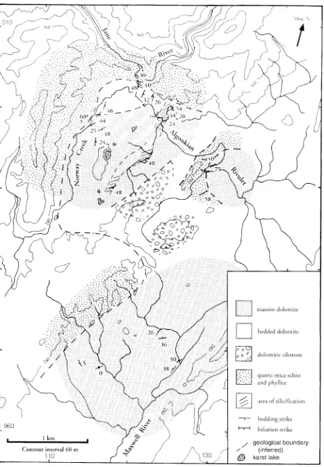
Most of the low-lying areas of the broad valley of lower Algonkian Rivulet-upper Maxwell River consist of dolomite, The higher surrounding, hills and ridges comprise presumed older Precambrian rocks. A geological map of the area is shown in figure 1.
Older Precambrian
Rocks
These rocks consist of fine-grained purple and greenish phyllites (to the northwest of the area) and quartz-mica schists. A pervasive foliation is ubiquitous, and this appears to have been gemly folded. However, at DN 132992 a regular crenulation of this foliation was noted and complex, small scale folds were also observed, both trending east-west.
Massive
Dolomite
This rock is a grey, massive, fine-grained, granular dolomite. Distinct jointing is irregularly developed in some areas, with two distinct subvertical joint trends (220° and 320°) noted at DN 113964. Patches of grainstone occur in some_ outcrops, and low-angle cross bedding was observed within 0.1-0.3 m thick, more-silry seams. Eq�ivocal stromatolitic laminations occur at DP126000 and DNJ 27964. At DN127964, rhe dolomite is essentially massive, but sporadic, thin (up to 10 mm), silty layers exhibit gradation with respect of dolomite content, and produce differential reliefon weathered surfaces. Dolomite was briefly examined at two locations further down the Maxwell River valley, DN094788 and DN085877. Here the dolomite is generally similar to the massive dolomite described above, with sporadic banding and rare "graded" silry beds. It dips very slightly south or southeast.
Bedded Dolomite
14 Grant Dixon
Dolomitic Siltstone
This rock outcrops extremely poorly and, where exposed, is very weathered. It appears to comprise several of the low ridges on or near the Algonkian-Maxwell watershed.
Quaternary Gravels
Extensive lowland areas are mantled with surficial deposits of variable thickness up to at least 0.5 m, are well exposed in creek sections and consist of poorly sorted quartzitic and quartz gravels in a sandy or (less commonly) clayey sand matrix. The provenance of the clasts appears to be both the surrounding ranges and the secondary quartz in the dolomites (see below).
Silicification of the Dolomite
The massive dolomite is silicifled in several areas, but the degree can vary even 'within a given locality. Quartz occurs as segregations and veins within the dolomite. The quartz fills distinct "fractures", urelywith any consistent orientation, resulting in a "breccia" or "jigsaw" appearance of the rock. The fracture veins are separated by as little as a few centimetres, up to about 0.5 m. The quartz is milky and generally fine-grained, and may be banded or zoned parallel to the vein walls, suggesting distinct phases to deposition accompanying fracture opening. Quartz was also observed, albeit very rarely, as small (2-3 mm) crystals in vugs in the dolomite. Silicification of the dolomite is pervasive outwards from the veins.
The quartz veining forms an irregular boxwork in the dolomite. This is often spectacularly displayed in the roofs of overhangs and small caves, where the intervening carbonate has weathered out.
Similar occurrences of quartz in dolomite are observed in the Weld Valley-Mt Weld area in southern Tasmania and near Corinna in northwestern Tasmania. In the former case Calver (1989) has suggested they may be remnants of an ancient (TertialY?) silcrete. Fluid inclusion study of quartz from this area indicates low temperatures of deposition (C.R. Calver, pers. comm.). Silicified dolomite with veining and textures similar to the Algonkian Rivulet area has been described by Piaszczyk (1989) from near Corinna. He considered silicification was produced by a low temperature «200°C) fluid probably during late Proterozoic metamorphism.
STRUCTURAL RELATIONSHIPS
The dolomite strikes generally NE-SW and dips moderately to the southeast in the northern (lower Algonkian) part of the area, and to the northwest or is subborizontal in tbe southern (upper MaxwelJ) part of the area. It is gently folded, but this is rarely apparent in outcrop. Where hinges are observed (e.g. DP126000), very open folds plunge gently southeast. The dolomite appears unstrained, although jointing has been noted.
Dolomite overlies the older Precambrian rocks with low-angle unconformity, exposed at DP122004 in the bed of Algonkian Rivulet. No conglomerate, breccia or shearing is evident at the contact, although there is a small "disturbed"
area with steeper dips in the phyllite 50 i l l to the north, As noted previously, the older Precambrian rocks have a pervasive foliation, which has itself been folded to some degree, An east-west trending crenulation of this foliation occurs below the unconformity at DP 122004. However, the crenulation is not apparent in the overlying, more competent, bedded dolomite.
No conclusive evidence of facing was observed in the dolomites, but possible grading in some beds near DP123002 suggests they are not overturned. Civen the moderate dips, gentle folding and relationship to the older Precambrian rocks, the sequence is unlikely to be overturned.
DISCUSSION OF GEOLOGY
The uncont~)rmJble relationship of the dolomite to presumed
older Precambrian rocks, low tectonometamorphic grade and comparison with similar rocks elsewhere in Tasmania suggest a late Precambrian agt'!>for the dolomitic rocks
of
the Algonkian--lvlJA'Vvcll valleys.The lithology and general stratigraphic setting of the Algonkian-Maxwell dolomites suggest correlation with parts of the Weld River Group (Calver 1989), the Jane Dolomite, described from 30 km north (Spry & Zimmerman 1959) and the Success Creek Group and correlates in northwestern Tasmania (Williams 1976). These latter sequences have all been correlated at one time or another (Calver 1989, and others). However, unlike the Weld River Group, the Algonkian-Maxwell dolomites unconformably overlie rocks which have experienced at least one cleavage-forming event (the Penguin Orogeny?), and so are similar to the Jane Dolomite (as inferred by Spry & Zimmerman 1959).
Calver (1989) suggested a diminished Penguin Orogeny may have affected the Tyennan region (at least the Weld Valley area), but this appears not to be the case in the Algonkian-Maxwell area.
Karst Features
Whilst the topography of the area is relatively low-lying, many small, residual hills and small ridges rise abruptly from the lowlands to heights of up to 30 m. A few of these hills consist of older Precambrian rocks but many are dolomite. Bluffs may be developed on such ridges, in places with separated "towers".
Such bluffs are best developed in the more silicified dolomite, in the lower Algonkian valley. It is the location of a number of small caves and shelters or overhangs (including all the Aboriginal archaeological sites discovered during this survey). Such features also appear to be, at least in part, structurally related, with both large shelters in the 0 P 126000 area occurring in or near the hinge zone of open folds in the dolomite.
960
1 km
Contour interval 60 m 110
___ J
(~
J"I)~J
FIG. 1 - Geological map of the Algonkian-Maxwell area.
D
mJ
o~oc"" , ',~ ..
'/..-'(',\
;.
,,'
""-.-I~I
--r-t---r-l
/
,;
@
/
massive dolomite
bedded dolomite
dolomitic siltstone
quartz mica schist and phyllite
area of silicification
bedding strike
foliation strike
geological boundary (inferred)
[image:3.558.46.512.92.763.2]16 Grant Dixon
The most significant karst features in the area are the lakes situated on the broad between Algonkian Rivulet and Norway Creek in figure 1. Such karst lakes are rare in Tasmania. There are three Jarge lakes (the largest being 120 X 70 m in size) and several small ones. They occur in depressions, the northernmost one complex and uvala-like. The lakes have no apparent outlet, although the northern one (at DN 121997) may experience surface drainage to the south during periods of panicularly high water. However, the local vegetation suggests this is a rare occurrence. The water level of the larger lakes appears [ 0
fluctuate by about 0.5 m, but the occurrence of sphagnum around the margin of the northern lake suggests the water has been at its present low level for several years G. Whinam, pers. comm.). The lakes appear shallow, with deep clayey mud deposits, although one, with steep 20 m sides forming part of the depression, may have a water depth of several metres.
Pools and flooded do lines occur elsewhere in the Maxwell valley, often intriguingly located atop small hills, suggesting perched water tables, but nowhere else do they have the size or setting of the aforementioned lakes.
The northern lake lies on a line of dolines of various sizes extending northwards towards Algonkian Rivulet. Such doline trends are not uncommon, with the western fall of the ridge east of Norway Creek also pardy controlled by such a feature.
Many small, usually subcircular depressions, up to 10 or 15 m in diameter, occur throughour the area. They are partly infilled by sediment, with evidence they were once water-filled, and are still occasionally inundated. They display sharp discontinuities in the vegetation, with the flat floors occupied by very simple communities including mosses and, in one case, a rare sphagnum.
The lakes and in filled dolines in the area may have con-siderable potential for palynological studies.
In the upper Maxwell valley, where the dolomite is less silicified and generally flatter-lying, the karst features have a different character. At DN126967 a stream cave more than 30 m in length, with a pardy-phreatic side passage also some 30 m in length, has developed. The stream sinks in a large collapse doline and flows completely through a small hill. Rudimentary decoration and clastic "microspeleothems" occur.
Well-developed rillenkarren occurs on outcrops in an alkaline pan at DN127964 and on bluffs in the DN113964 area. Grikes and small fissure caves also occur in the DN 1 J 3964 area, development of the former having been controlled by two major sub-vertical joint orientations in the dolomite. The presence of small "foot caves" or notches on the southern side of the bluffs at DNl13964 suggest higher water levels and/or an alternative course of the adjacent stream in the past.
Drainage Pattern and Geomorphic History
The reconnaissance nature of the investigations described herein preclude detailed discussion of the geomorphic history of the area, but some general conclusions can be made.
The generally orthogonal drainage pattern, with directions apparently similar to major joint orientations in the dolomite (particularly in the upper Maxwell valley), the observed structural control of many of the karst features and the presence of numerous dolomite residuals suggest that
drainage developmem has probably been controlled by the
jOllitlng.
Given the inactive nature of most of the karst features, that dolomite generally occupies the lower parts of the landscape with numerous residuals and that the present drainage is largely surficial, the area is considered,to be in "old in terms of its geomorphic history. Much karst development probably occurred during Late Pleistocene times, or earlier, with more recent deposition of much of the Sll rficial gravels.
Soils
Soils in the lower Iv1axwell valley have been described by who noted considerable variation in soils and substrates. He noted organic soils (peats), a Imost entirely fibrous, as the domi tlallt soil, developed over gravelly and loamy materiaL
In the Alg()nkian~Maxwell area there is considerable variation in soils, due mainly to the dolomite bedrock and karst-related environments. The forested areas of older Precambrian bedrock have shallow organic horizons over clay loams, as noted by Pemberton (1989) for his South-West land system which includes the surrounding ranges. Skeletal, gravelly soils occur on some ridge crests.
Brown fibrous peat is common throughout the area, occurring beneath both buttongrass heath and closed teatree scrub (the latter with a thick litter layer). In most areas it overlies, or grades into, fine siliceous gravels. Whilst soil pHs (measured in the field with an Inoculo CSIRO test kit) of 3.5-4.5, typical of other parts of southwestern Tasmania (M. Pemberton, pers. comm.), do occur in the area, pHs of the peats are often around 5.5 . This presumably reflects the carbonate bedrock, or at least drainage therefrom. Dark muck peats occur in poorly drained areas.
Other soils noted in the area include alluvial sandy loam (pH 5.5-6) occurring along Norway Creek, sandy clay loam (pH 4-4.5 ) and pale-brown sand (pH 6.5 ) noted in two infilled dolines, black clayey ooze (pH 6) and dark-brown clay (pH 5) occurring adjacent to and beneath the karst lakes, and thin sandy loam (pH 6 to 6.5 ) occurring on dolomitic siltstone.
Soils on the alkaline pans (see below) consist of thin, cream-coloured, in places clayey, sand with pH ranging from 7 to 9.
Alkaline Pans
Brown et al. (1982) described alkaline pans from the Hardwood River valley. Such pans are also known to occur in the Maxwell and Giblin River valleys and Sandfly Creek area, near Mt Anne Garman et
aI.,
1988). Pans in the Giblin and Hardwood valleys are related to limestone bedrock and those in the Maxwell valley and Sandfly Creek areas todolomite bedrock. Jarman et al. (1988) described two broad classes of vegetation characteristic of pans and suggested that the botanical differences may be related to bedrock type. However, the two rypes are not always mutually exclusive (op. cit'), as exemplified by some alkaline pans in the upper M;L'{Well valley (L. Gilfedder, pers. comm.).
the upper Maxwell valley, south from DN127964, and range in size from a few square metres to more than 800 m2. The pale pans with their sparse, open vegetation contrast sharply with the surrounding buttongrass-heath vegetation, as described by Brown etaL (1982), and so are conspicuous, particularly on aerial photographs.
A feature of all the alkaline pans observed is their location at the foot of steep slopes. In the case of the pan at DNl13963, steep slopes occur on all sides of the pan. With the exception of the pan-like area at DN 123995 (located on a small creek line) all pans observed are situated immediately adjacent to main drainage lines. Their surfaces are wet and they experience periodic sheet wash, in addition to seepage from the adjacent slopes - often from several directions in the larger, more complexly-shaped pans. The pans occur in areas of dolomite bedrock, with low « 0.3 m) outcrops in the floor of the larger, better developed pans. Brown et aL (1982) noted reprecipitated carbonate (as concretions on pebbles) in alkaline pans in the Hardwood valley, but no such features were noted on the Algonkian-Maxwell pans. This may be a function of the dolomitic, compared to limestone, bedrock.
The soils of several alkaline pans, or pan-like areas, were examined in the field. An Inoculo CSIRO test kit was used
to determine pH.
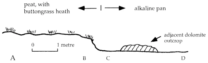
The pan at DN 127964 is large (> 800 m2), irregular in shape and has numerous areas of exposed dolomite bedrock. Soil descriptions in a transect across a typical edge to this pan are given in figure 2. The spectacular increase in soil pH (4 units over 0.3 m) at the edge of the pan is of particular note.
In the major inflow region of the pan described in figure 2 (subject to seepage and periodic sheet wash) is a delta-like area with more than 0.2 m depth of sandy siliceous gravels (pH about 6). There is an apparent size sorting to smaller pebbles farther out into the pan. These pebbles are probably reworked from the surrounding surficial deposits.
The pan at DN113963 in the upper Maxwell valley is about 30 m across and surrounded by steep slopes. Dolomite bedrock is not exposed, and occurs at more than 0.1 m depth beneath the cream-coloured clayey sand of the pan. There is a distinct surface-water flow from the northwest of the pan, with siliceous gravels concentrated in the south-eastern corner. Soil pH (at about 50 mm depth) is 8-8.5 in the pan centre, 7.5-8 at the edge, and 7-7.5 near the inflow area.
A
peat, with
buttongrass heath
B
Two pan-like areas occur north of an east-west trending dolomite ridge in the DN124995 area. These pans are wetter than those described above, contain small mounds with vegetation more typical of the surrounding peats and soil pH is somewhat less alkaline. They are incipient pans, possibly undergoing a process of invasion. Brown et aL (1982) suggested alkaline pans are a short-term (albeit up to several hundred years) feature of the landscape, which are slowly in filled by sedimentation and encroached upon by the surrounding peat.
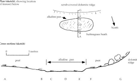
The "pan" at DN124995 (fig. 3) is about 40 X 10 m in size and slopes around 4° to the east. Periodic surface flow occurs downslope, and subsurface seepage occurs from the dolomite ridge to the south. (At the time of observation the local water table was at 0.05 m depth at F and 0.4 m depth at B.)
About 100 m up-valley to the west of the DN124995 (figure 3) "pan" a pan-like area is located on a drainage line. Cream-coloured sand (pH 7) occurs in the centre of the "pan", brown fibrous sand (pH 5.5-6) at the edge, and dark brown peaty clay loam (pH 4.5 ) in the adjacent area (all within a distance of 2 m). An algal mat-covered area of the pan has sand with pH 6.5 .
The occurrence of peat beneath the sand of the pan at DN124995 and the absence of dolomite bedrock at shallow depth suggests that the reasons for the formation and existence of this "pan" may be somewhat different from those of others in the upper Maxwell area, described previously. Brown et al. (1982) suggested pan formation may be initiated by severe peat-burning fires. In the case of the DN124995 pan, such a fire may have not completely destroyed the now sub-pan peat but promoted alkaline run-off, erosion on slopes and sedimentation from the surrounding area.
Outcrops of dolomite in the large alkaline pan at DN127964 display two or three "steps", apparently a result of dissolutio'n, up to 0.2 m above the present pan surface. A one metre high dolomite outcrop protruding from another pan several hundred metres to the southwest shows spectacular undercutting (of up to 0.2 m) near its base, also apparently a result of dissolution. As noted previously, Brown et aL (1982) considered alkaline pans to be relatively short-term phenomena in the landscape. However, these dissolution features suggest the pans may also be repeated (in time) features of the landscape, dissolution of the dolomite occurring during previous pan "lives", when they and/or the encroaching peat were at a slightly different level.
c
alkaline pan
adjacent dolomite outcrop
D
FIG. 2 - Transect across margin of alkaline pan, DN127964. (A) 0.3 m dark-brown, fibrous peat overlying less fibrous, rather
organic-rich clay loam, pH
3.5-4.
(B) 0.12 m dark-brown, organic-rich clay loamlpeat over(ying clay loam with coarse (> 10 mm)quartz gravel, pH
4.5
(50 mm depth),3.5-4
(0.1 m depth).(C) 5
cm grey-cream-coloured sand on dolomite bedrock, [image:5.562.100.458.633.741.2]18 Grant Dixon
Plan (sketch), showing location
of transect below scru b-covered dolomite ridg<'
G '"---I - -I 1 1
-. I I I
alkaline pan ...
Cross section (sketch)
o
5 metresL
.... _ _ _ _
--.JB
A buttongrassheath
\
North
peat
I ....
alkaline panA B C D E F G
Fig. 3 ~Alkaline pan at DN124995. (A) 0.4 m dark-brown, peaty cla.y loam with sporadic siliceous gravel, overlyingfine siliceous gravels, pH
4
(at 50 mm and 0.3 (B) Dark-brown, mucky fibrous peat with minor siliceous gravel, becoming sandy at 0.45- 0.5 m depth, pH4.5
at 50 mm,5.5-6
at 0.45 m. (C) 60 mm cream-coloured sand overlying grey-brown, fibrous, pellty sand, pH65-7.
(D) 0.1 m cream-coloured sand ollerlying gr~y, fibrous sandy peat, pH7
at 50 mm. (E) Sandy clay, grading to clay over 20cm, pH5.5-6
(F) Very dark-brown, mucky fibrous peat with clay, pH4.5.
(G) Brown, fibrous clay loam, becoming less fibrous with depth, pH5
at 50-100 mm,4
at 0.5 m depth.Therefore, with time, pans may recur in certain locations (perhaps initiated by severe fires, as Brown et al. [1982]
suggested), and it follows that their specific location is probably related to local topographic, hydrologic and/or geologic factors.
ACKNOWLEDGMENTS
I wish to thank the Archaeology section, Department of Parks, Wildlife and Heritage, and particularly Brian Prince, for the opportunity to visit the area. M. Pemberton, M.R.Banks, E.Wil!iams and C.R.Calver are thanked for useful suggestions.
REFERENCES
BLAKE. P., 1936: Report on district between Jane River and Prince
of Wales Range. Department of Mines, Geo!. Survey Typed Reports.
BROWN. M.J., CROWDEN R.K & JARMAN, S.]., 1982: Vegetation of
an alkaline pan-aciJic peat mosaic in the Hardwood River
Valley, Tasmania. Aust.jEcology 7: 3-12.
CUVER, C. R., 1989: The Weld River Group -- a major upper
Precambrian dolomite sequence in southern Tasmania. Pap
Proc. R. Soc. Tasm. 123: 43-54.
CANTLE, L, 1979: Jane Rivering. Southern C,wer 9: 9-10.
CORBET!", K D. & BROWN, A. V., 1975: Queenstown, Tasmania.
Tasm. Dep. Mines 1 :250 000 CeoI. Atlas Series, sheet
SK55/S.
JARMAN, S. J., MNTVlIAS, G. & BROWN, M.
J.,
1988: Bunongrassmoorland in Tasmania. Tas. Forest Research Council, Res.
Rep. 2: 50-·51.
PIASZCZYK, D., 1989: The characterisation and genesis of the silica
flour deposits at Corinna. U npub!. B.Sc.(Hons.) thesis,
Geo!. Dep., Univ. of Tasm.
PEMBERTON, M., 1989: LAND SYSTEMS OF TASI'v1ANIA REGION
7--SOUTH WEST Department of Agricul cure, Tasmania.
RANSON, D. & l-LIRRTS, S., 1986: Maxvvell River archaeological
survey. Tasmanian NPWS. Report of survey, National Estate
Grant 84/85, No.8.
SPRY, A. & ZIMMERMAN, D., 1959: The Precambrian rocks of
Tasmania, part IV - the Mt. Muliers area. Pap. Proc. R.
Soc. Tasm. 9.3: 1-9.
TARV¥OAS, R. K,1978: LOWER GORDON RIVER SClEN77FIC
SURVEY-SOILS. Hydro-Electric Commission, Tasmania.
WILLIAMS, E., 1976: Explanatory notes for the 1:500 000 structural map of pre-Carboniferous rocks of Tasmania: Tasman Fold Belt system in Tasmania. Tasmanian Dept Mines.
[image:6.568.60.518.82.354.2]