Abstract: In Developing countries like India, analysis of safety issues on urban roads for Non-Motorized road traffic accidents in Indian cities (Srinagar city) where fatalities constitute approximately 25 % to 50% of the total traffic deaths is important. The NMT mainly comprises of pedestrians and bicyclists. The present study focusses on using video camera through image capture analysis and 13 different locations have been selected. The usage of latitude and longitude from google earth some of locations were selected in the CBD area of Srinagar city. The present study method is before study and after study location scenario (BSL-ASLS method) was used to identify necessary safety measures along the NMT lane with high traffic volumes on urban roads under mixed traffic conditions. The behavior of the NMT users plays a vital role in the characteristics of road accidents in Srinagar city. The final results clearly indicate that in the form of pie charts are shown at the end and there is a crucial need for providing a safe and separate lane for NMT (pedestrian and bicyclists) users in Srinagar city. The government should also develop a good policy/strategy regarding NMT and should provide a barrier in segregating the motorized and non-motorized traffic. There is a scope and need to carry out more research work in this area so as to improve the Non-motorized transport safety measures.
Keywords: NMT safety issues, NMT policy, pedestrian safety measures, Bicycle safety measures.
I. INTRODUCTION
In India, Two-wheelers are the most helpless and unprotected street client talented in street mishaps in the nation consistently. The portion of bike clients slaughtered in mishaps expanded from 31.5 percent in 2015 and to 34.8 percent in 2016. During 2016, other street clients executed in street mishaps are autos, navigates, vans and other light and medium engine vehicles(17.9percent), trucks(11.2percent), walkers (10.5 percent), transports (6.6 percent), auto-rickshaws (4.7 percent) and others engine vehicles (10.6 percent). Street clients of non-mechanized vehicles like creatures have drawn vehicles, cycle rickshaws, pushcarts, and other-individual gifted in street mishaps represented 2.0%of complete people murdered during 2016. A relative table of passing’s in street mishaps by street client type in 2015and 2016 is given beneath. Table 1 depicts the portion of street mishap passing’s by client type in 2016. State/UT-wise information in regard to various people slaughtered in street mishaps in terms of street client classifications during 2016. Old city of Srinagar consists of a number of small access roads forming a dense street network. Population densities of
Revised Manuscript Received on December 05, 2019.
Badveeti Adinarayana, Ph.D Research Scholar, Department of Civil Engineering, National Institute of Technology Srinagar, India - 190006
Dr. Mohammad Shafi Mir, Professor, Department of Civil Engineering, National Institute of Technology Srinagar, India - 190006
Email Id: badveetiadi@gmail.com, badveetiadi_16@nitsri.net, shafi@nitsri.net
the old city are also the highest in the city. While there are pressures of motorization, the old city’s charm and architecture demands that it should be dealt with separately as a zone and served with a high quality public transport service, with an emphasis on walking and cycling, thereby reducing demand on parking provision. It is therefore recommended that a set of rules governing the transportation inside the old city shall be framed subsequently, in consultation with the stakeholders. The rules shall be framed in the spirit of promoting walking, cycling, public transport and reducing parking demand with increase in shared spaces for recreation and transportation use.
Non-Motorized Transport (NMT) User Safety
Guidelines in Urban Areas of Developing Countries
Non-Motorized Transport (NMT) User Safety Guidelines in Urban Areas of Developing Countries
Source: Ministry of Road Transport Highway Authority (MORTH, 2016)
II. OBJECTIVESOFTHESTUDY The research objectives are as under:
i) Identification of safety guidelines for Non- motorized transport (NMT) on urban roads under heterogeneous environment conditions.
ii) To suggest safety countermeasures for Non- motorized transport (NMT) in urban areas of developing countries under mixed traffic conditions.
III. LITERATUREREVIEW
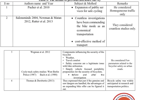
[image:2.595.49.534.77.292.2]The current review of the literature was based on the safety of Non-motorized transport modes like bicycle and pedestrians in urban areas of developed and Developing Countries and as shown in Table 2.
Table 2. The details of previous literature survey
S no Authors name and Year Subject & Method Remarks
1 Pucher et al. 2010 Expansion of public ser
vices for safe cycling
He considered Homogeneous traffic
only 2 Salensminde 2004, Newman & Matan
2012, Rutter et al. 2013
Countless investigations have been commending the bike mode as an economical
transportation
cost-effective method of transport
They considered countless studies only.
3 Wegman et al. 2012
Cycle track safety studies: West Berlin Police (1987) Bach et al. (1988)
Components influencing the security of the bicyclist
• Weather, • Travel comfort
• Safety concerns are a legitimate issue with bike utilization.
• Simply vehicle focused portability propensities for the security of bicyclists.
Before and after the
investigation
He considered Few parameters related to the bicyclist safety on urban
roads.
4 Thomas & Derobertis (2013) They expressed that just if the genuine and saw dangers are handled, the advantages of an expanding bike offer can be figured it out.
[image:2.595.66.542.442.777.2]Bicycle safety was widely anticipated in research and transportation politics. Table 1. Total Number of Persons killed in Road Accidents in terms of Road Use Categories in 2015 & 2016
Road Users No. of persons killed
during 2016
No. of persons killed during 2015
1. Pedestrian 15,746 (10.5) 13,894 (9.5)
2. Bicycles 2,585 (1.7) 3,125 (2.1)
3.Two-wheelers * 52,500 (34.8) 46,070 (31.5)
4. Auto-Rickshaws 7,150 (4.7) 7,265 (5.0)
5. Cars, Taxis, Vans & LMVs 26,923 (17.9) 25,184 (17.2)
6. Trucks 16,876 (11.2) 16,611 (11.4)
7. Buses 9,969 (6.6) 10,743 (7.4)
8. Other Motor Vehicles (including
e-rickshaw) 15,988 (10.6) 18,557 (12.7)**
9.Others (Animals drawn vehicle, cycle rickshaws, handcarts,-&other persons)
3,048 (2.0) 4,684 (3.2)
10. Total 1,50,785 (100.0) 1,46,133 (100.0)
5 Holm et al. 2012 They proposed that cycling is a sound method of transport.
Bicyclist safety measures.
6 Juhra et al. 2012 Overall travel distance for
bicyclists.
Bicyclist safety measures.
Lack of bicycle safety measures on urban roads.
7 Brilon (1997) They proposed that cycling is a
sound method of transport.
He finds marking cycle lanes next to the circulation increased bicycle accidents from 1 to
8 at three roundabouts.
8 Schoon and van Minnen
(1993)
No bike office at high traffic volumes at roundabouts.
They recommended that different cycle ways are more secure than roundabouts.
They considered Roundabouts only
9 Larsson(1999a) and
Sakshaug et al. (2010)
Special cycle intersections are more secure at higher traffic volumes than roundabouts without bike offices.
They considered Roundabouts only
10 Daniels et al.(2009,
2010)
Roundabouts with independent cycle ways are more secure than roundabouts with no bike offices.
He finds that roundabouts with checked cycle paths alongside the flow are less safe for cyclists than roundabouts with-out bike offices.
They considered Roundabouts only
They considered Roundabouts only
11 Jorgensen (1991) Higher at roundabouts without bike offices however
most noteworthy at roundabouts with stamped cycle paths.
He shows that the damage rate is most minimal at roundabouts with cycle tracks by the flow
He considered Roundabouts only
12 Brüde and Larsson
(1999a)
The mishap rate for cyclists is twice as high at little roundabouts, where the focal island including truck cover is under 20 m, contrasted with bigger roundabouts.
they considered Roundabouts only
13 Hels and Moller (2007)
and Turner et al. (2009)
They find that as drivers' entrance and flow speed at roundabouts increment at that point bike security exacerbates.
They considered Roundabouts only
14 Lieb & Sommer 2007, Timilsina & Dulal 2011
Traffic congestions were reduced due to implementing of NMT mode of transportations
No segregated lanes for NMT mode of transportation.
15 Keuken et al. 2005 Reduced air pollutants by implementing of NMT
mode of transportations
Lack of NMT lanes
16
17
Lakes et al. 2013,Laussmann et al.
2013
Meschik 2012
social-environmental injustice
limited studies on bicyclists on urban roads
No segregated NMT tracks
IV.STUDYMETHODOLOGY
The present methodology aims study of using Image capturing Analysis Before-After study scenario (B-A method) of selected study locations on urban roads under mixed traffic conditions and the characteristics of road accidents involving NMT users to find out the suitable safety measures along the NMT lane with high traffic volumes on urban roads under mixed traffic conditions. This examination manages NMV inclusion in street car crashes in Srinagar during the time of 2015 to 2017. The field surveys were conducted at Lalchowk, M.A road, Nishant garden and Boulevard road around Dal lake in the area of Srinagar city on urban areas. Possible NMT
Non-Motorized Transport (NMT) User Safety Guidelines in Urban Areas of Developing Countries
Figure 1. Study methodology
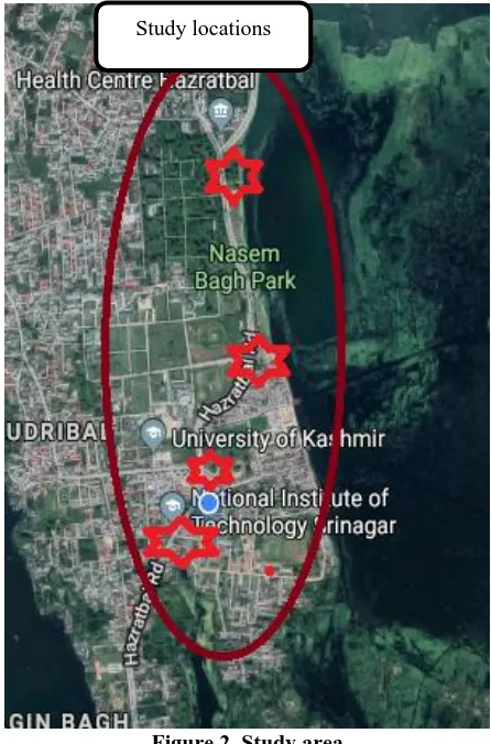
V.SELECTIONOFSTUDYAREA
The selected locations of high pedestrian flow and location of junctions along with the Stretch length of 2.8 kilometers from NIT road junction, junction, Kashmir university road junction, road junction, Kashmir university Main gate road junction and foreshore road junction were studied and for these selected locations are given in Figure 2.
Figure 2. Study area Source: Google map
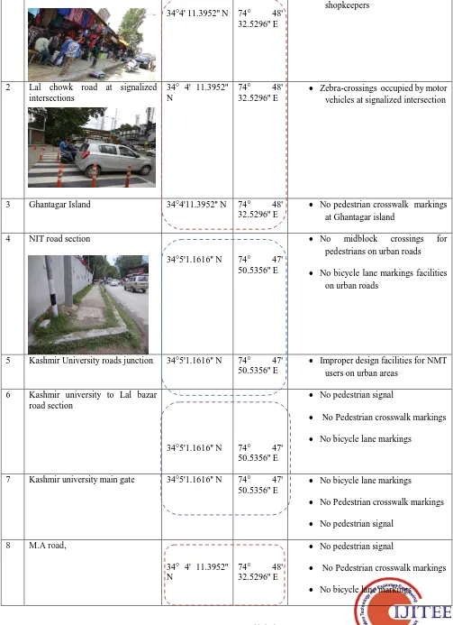
VI. SELECTION OF STUDY LOCATIONS
For this study we captured the image of selected locations and through Latitude and Longitude of google earth at 13 different locations in the CBD areas of Srinagar city under mixed traffic conditions and as given in Table 2.
Jammu & Kashmir State
Srinagar metropolitan area
Non-Motorized Transport (NMT) User Safety Guidelines in Urban Areas of Developing Countries
Table 3. The details of study location, Latitude and Longitude of selected location S.
No
Study location Identified NMT Safety issues
1 Lal chowk market area
34°4' 11.3952'' N 74° 48' 32.5296'' E
Pedestrian sidewalks occupied by shopkeepers
2 Lal chowk road at signalized intersections
34° 4' 11.3952'' N
74° 48'
32.5296'' E
Zebra-crossings occupied by motor vehicles at signalized intersection
3 Ghantagar Island 34°4'11.3952'' N 74° 48'
32.5296'' E
No pedestrian crosswalk markings at Ghantagar island
4 NIT road section
34°5'1.1616'' N 74° 47' 50.5356'' E
No midblock crossings for
pedestrians on urban roads
No bicycle lane markings facilities on urban roads
5 Kashmir University roads junction 34°5'1.1616'' N 74° 47' 50.5356'' E
Improper design facilities for NMT users on urban areas
6 Kashmir university to Lal bazar road section
34°5'1.1616'' N 74° 47' 50.5356'' E
No pedestrian signal
No Pedestrian crosswalk markings
No bicycle lane markings
7 Kashmir university main gate 34°5'1.1616'' N 74° 47'
50.5356'' E
No bicycle lane markings
No Pedestrian crosswalk markings
No pedestrian signal
8 M.A road,
34° 4' 11.3952'' N
74° 48'
32.5296'' E
No pedestrian signal
No Pedestrian crosswalk markings
No bicycle lane markings
9 Nishant garden
34° 05' 8.34'' N 74° 48' 19.98'' E
Improper road geometric design facilities for NMT users on urban areas
No Pedestrian crosswalk markings
No bicycle lane markings for bicyclist
10 Boulevard road section 34° 06' 60.00'' N 74° 51' 59.99'' E
Improper road geometric design facilities for NMT users on urban roads
12 Dal gate road junction
34° 06' 60.00'' N 74° 51' 59.99'' E
No bicycle lane markings
Improper road geometric design facilities for NMT users on urban areas
No Pedestrian crosswalk marking
13 Nishant park road 34° 05' 8.34''
N
74° 48'
19.98'' E
Improper road geometric design facilities for NMT users on urban areas
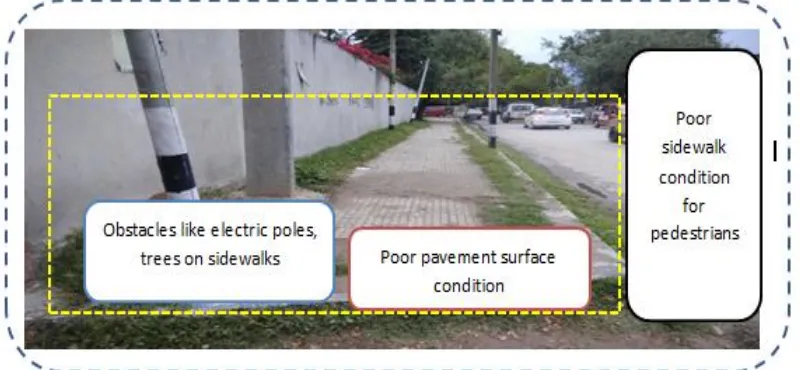
VIII. IDENTIFICATION OF NMT INFRASTRUCTURE ISSUES IN URBAN AREAS It has been used for video camera through captured image of selected locations and then identified the followed safety issues of Non-motorized transport in CBD areas of Srinagar
metropolitan area under mixed traffic conditions and as shown in Figure 3 and Figure 4.
Non-Motorized Transport (NMT) User Safety Guidelines in Urban Areas of Developing Countries
Figure 4. The detail of poor infrastructure facilities for pedestrian sidewalks on urban roads
From the figure 2. it has been identified the followed safety issues of Non-motorized transport and the above image shows details of Improper design, unpaved infrastructure facilities, presence of obstacle, presence of gross and trees on sidewalks without maintaince and discontinuity of sidewalks along road network in Srinagar metropolitan areas
IX. BEFORE STUDY AND AFTER STUDY LOCATION
[image:8.595.70.513.372.668.2]The before selected study areas and after proposed study areas plan for Non-motorized transport (NMT) in urban streets under mixed traffic conditions and as appeared in Figure 5 and Figure 6.
Figure 5. The details of existing and proposed NMT tracks for urban arterial roads Source: Srinagar Municipal Corporation (www.smc.gov.in)
X. BICYCLE INFRASTRUCTURE SAFETY ISSUES
In Boulevard to Nishat garden street, there is an absence of physically separate selective bike offices from mechanized traffic by controls, left autos, platers, delineators… and so
Figure 6. The image of No-cycle track infrastructure lanes at Nishat garden road
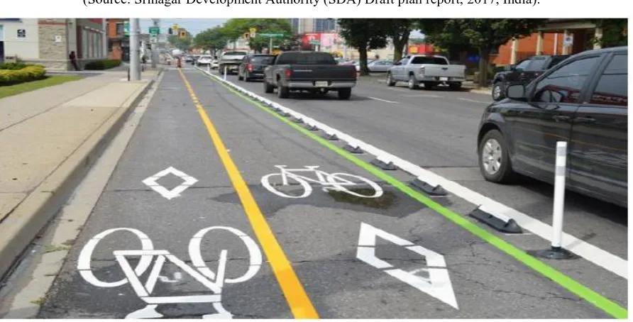
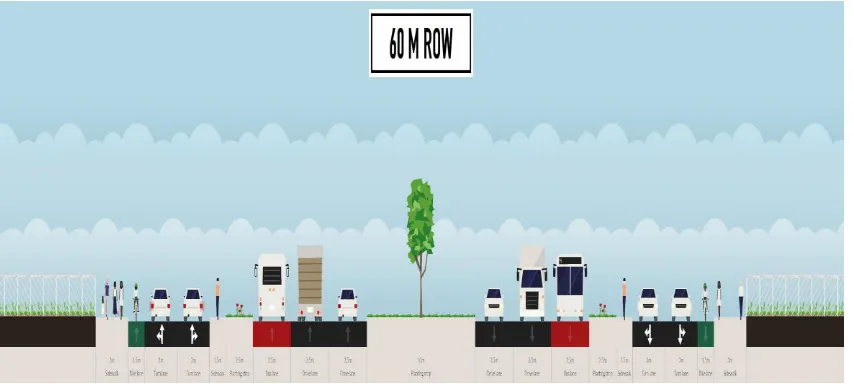
Figure 7. The details of proposed NMT road cross section
(Source: Srinagar Development Authority (SDA) Draft plan report, 2017, India).
[image:9.595.78.524.494.721.2]Non-Motorized Transport (NMT) User Safety Guidelines in Urban Areas of Developing Countries
XI. LAL CHOWK AREA
[image:10.595.99.494.68.289.2]Retrofit: Lal Chowk Heritage District –Residency Road–Lal Chowk Plaza Improvement as shown in Figure 9.
Figure 9. The existing condition for M.A road
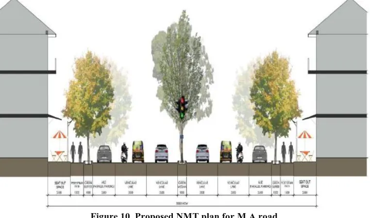
Figure 10. Proposed NMT plan for M.A road Source: Srinagar Municipal Corporation (www.smc.gov.in)
XII. NON-MOTORIZED TRANSPORT (NMT) FACILITIES FOR SRINAGAR CITY
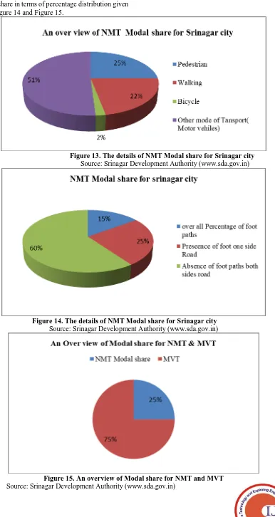
In Urban areas of Developing countries like in Indiancities, more than 75% trips are less than 10 km and average trip length for such cites is less than five km 42. Unlike other metro cities 43 in India, the NMT modal share for Srinagar city is about 25%. According to the MoUD Report (2008), ‘walking remains the dominant form of travel in cities with pedestrian share remaining around 24 – 25%.’ Every public transport trip has a component of walk at its both ends. Though pedestrians are short distance travellers, they are spread all over the city. As per the CMP, about 22% of the total trips are walk trips in Srinagar city. Also more than 60% households do not own a vehicle and 2% of the households possess just a bicycle only. Per capita trip rate including walk is 1.72 and excluding walk, it is 1.35. All these figures point towards a healthy pedestrian traffic which has to be sustained
and given impetus by developing adequate pedestrian infrastructure in terms of FoBs, underpasses, footpaths, pedestrian signals at intersections etc. Unfortunately, only 15% of our roads has footpaths with 25% of them having it on one side only. Walkers are among the most defenseless street clients in our urban communities and accordingly need an adequate framework for their freedom from any potential harm development along city streets. As per the Index of Conflict (PV2)44, a number of roads and intersections have been identified where the pedestrian – vehicular conflict ratios are very high. The highest pedestrian-vehicular conflict ratios are observed at Jahangir Chowk, Karan Nagar Chowk, SKIMS Chowk, Batamaloo, SMHS Hospital, Pantha Chowk, Dal Gate, JVMC Bemina, Kashmir University Hazratbal, etc. Basics of pedestrian infrastructure are absent and even street poles stand in the middle of
[image:10.595.108.489.331.555.2]design codes in the development of Pedestrian facilities and the ramps required for persons with disabilities. The roads need to be properly marked with stop lines, cross-walks, direction arrows and other delineators to streamline pedestrian movement. It is also proposed that pedestrian cycle be added in traffic signal phase at all signalized locations for at-grade movement of pedestrians instead of forcing them to use FoBs. Besides, at other critical locations other than intersections, a dedicated pedestrian signal be installed for safe movement of pedestrians. Preferred walking distance is 500 metre or less hence persons living within 500 metre distance from an interchange station have the highest accessibility to it. Beyond 500 metre distance, the commuters will need reliable and cost effective feeder services. According to CMP, about 5200 commuters travel by Auto in Srinagar on a typical day. Though average trip length by Auto is not available, it is assumed that 75% of such trips will be short trips less than two km in distance. A trip by Auto is not economical and is roughly 10-15 times costlier than a bus trip. As such, it is proposed to introduce E-Rickshaws (4-6 seats) within city limits as a short trip feeder service. It is emphasized that the number of E-Rickshaws be initially restricted to 250 and subsequently reviewed as per the demand. Besides, their operations shall be restricted to local streets or access roads only or to the nearest bus stop as provided in this master plan. As per CMP, average walking trip length is 1.2km or less hence persons living within 1.2km distance from an interchange station have the highest accessibility to it. Beyond 1.2km distance, the commuters will need reliable and cost effective feeder services or cycling infrastructure to fill in the gap.
BICYCLE FACILITIES: It could be a significant method of movement, especially regarding short and medium excursion lengths. To the degree that it meets individual or open vehicle necessities, it is a non-vitality devouring and non-dirtying method of transport. In any case, there are a few issues that must be kept in see while arranging in regards to these modes. With a blended kind of quick-moving traffic on the streets, travel by bike and rickshaws is extremely perilous. The information has indicated that a small amount of workers utilizes cycles for driving because of the absence of safe cycling offices or cycle stopping offices.
In perspective on the abovementioned, the accompanying moves ought to be made:
Prepare a cycling masterplan for the city that makes a system of courses incorporating every blood vessel street, eco-portability halls along Dallas, legacy courses, school areas just as other recreational courses.
On all blood vessel and sub-blood vessel streets completely isolated cycle/NMT tracks ought to be given arrangement for safe stopping in the recreation center and ride parcels. Any place full ROW isn't accessible, the cycles/NMT might be permitted to stream in blended rush hour gridlock conditions.
In all territories of the city, the utilization of cycles as a non-mechanized method of transport ought to be intentionally arranged alongside pedestrianisation. Plan and actualize city-wide, moderate and open cycle
sharing/rental plans to empower open travel clients specifically and open as a rule to utilize cycle as a mode to
play out their first and last-mile venture just as to make normal short outings without utilizing private vehicles. A cycle sharing/rental framework ought to be arranged
and executed by any administration open vehicle office including a proprietor and an administrator, where the administrator could be a private organization giving essential administrations. The surviving rules in such a manner might be pursued.
In case the new person on foot/NMT systems should be included developed/created zones, proper impetuses might be given. Nitty-gritty cycle sharing framework strategy and rules will be set up by concerned neighborhood bodies independently. A great bike framework should be given and an advantageous bike-sharing framework ought to be created, which will help take shorter excursions off the blood vessel streets (thusly diminishing stop up). Encroachment of bicycle tracks and theft or vandalism of bicycle sharing structure should be made a cognizable offense under the Municipal Act/MV Act or some other significant Acts.
The bike infrastructure should be ceaseless, obstacle-free and with unmistakably delineated bike tracks or paths with great signage, street checking, lighting, in any event, one line of tree shade and more bike stopping regions. The bike framework should be furnished at a more significant level with secured edges, to forestall rainstorm flooding or infringements by left vehicles. Convergences need to have bike lining plans and devote bike signals for the simple traverse. For enormous intersections, rotaries and for block by arterials or conduits or railroads, extraordinary bike
underpasses, scaffolds or slopes might be
structured/accommodated.
Bicycle tracks ought to be at least 2m wide for single bearing and at least 3m wide for the two headings. For tracks having pedal rickshaw development, at least 2.5m wide for single bearing and 4m wide for the two headings ought to be given.
All lanes above 30m option to proceed need to have committed bike tracks. The bike-sharing framework ought to be founded on a thick system of stations set around 300-400m separated and having fewer bikes per station (10-50) with docks 1.5 occasions the number of bikes in each station.
Non-Motorized Transport (NMT) User Safety Guidelines in Urban Areas of Developing Countries
PEDESTRIANS FACILITIES: It is the most significant and manageable method of transport. In Srinagar, about 22% of the suburbanites of the city use strolling as the main method for movement for short outings, notwithstanding open vehicle clients. Along these lines, the privilege to walk securely is a non-debatable condition. For this,
The accompanying advances should be taken:
• All streets must give legitimate trails according to road plan guidelines and the satisfactory portion of strolling space inside ROW.
• All walker offices ought to be without a boundary for general access by all people with decreased portability incorporating those with hearing and visual hindrances. • All obstructions/infringements will be expelled from
pathways everywhere throughout the city to make a safe strolling conditions in all settlements, office/shopping zones, terminal zones and so forth which will urge more individuals to walk.
• As referenced in the NMSH Parameters (MOUD, 2011), at any rate, five safe road level intersection openings per kilometer of the street with roughly 250m being most extreme dispersing between two intersections ought to be given. Contingent upon setting, these intersections might be signalized or potentially traffic quieted to decrease vehicular speed and increment security.
• Pedestrian Signals ought to be synchronized with the closest full-traffic signals, for smooth development of traffic alongside a safe person on foot/NMT crossing. • Pedestrian arranged without vehicle spaces all through
Srinagar should be made. Significant work focuses, where the huge number of the person on foot systems rise and come full circle, ought to have improved offices for the people on foot.
• New zones should get ready for the person on foot zones, courts, action spaces dependent on areas of open vehicle hubs/stations, business focuses, private networks and nearby/city level goals.
• Street-level movement and well-watched roads should be made through blended-use, maintaining a strategic distance from misty limit dividers, the formation of selling/distributing zones and nonstop exercises, to guarantee a protected domain for people on foot.
• Planning, plan, execution, and support of person on foot courses and offices should be organized.
• As per NMSH parameters, to make dynamic boulevards for person on foot security and happiness: (I) Primary walker access for structures ought to be from the central avenue, with area according to most brief strolling good ways from closest transport stop; (ii) The principle building exterior should confront the road, situated on the property line without difficulty or with dynamic use inside set back and straightforward edge that add to lanes, Compound dividers, if present, ought to be straightforward over a stature of 100cm. High-security government structures may apply for the exception. Vending spaces ought to be set apart moreover and adjoining the strolling way, particularly along high walker volume regions to enact the road and make it safe. Space to be made arrangements for utilities including drinking water stands and toilets with the goal that the strolling space is upgraded however not trade off
XIII. RESULTS AND DISCUSSIONS
In Srinagar city in India, Though NMVs has been proposed NMT for the major arterials of Srinagar city, it has not been very valuable as per versatility and workableness reason. Then again, forbidding has diminished the measure of NMV mishaps, particularly in city zones. Of all the streetcar crashes that happened during 2015-2017, roughly 10 percent of them are NVM mishaps. 27 percent of those NMV mishaps are deadly, the loss rate is 30 percent. 26 percent of the complete mishaps have happened in city regions and the pattern is diminishing. Srinagar city has the most elevated offer in NMV mishap with 45 percent occurrences. Impact with substantial vehicles is one of the principal reasons for NMV mishaps. In 27 percent of mishap cases rickshaws have slammed into a mode of transport and in 24 percent cases, they have crashed into overwhelming trucks. Over speed and thoughtless driving are two most essential contributing components of rickshaw mishaps
Safety countermeasures to counteract NMV mishaps: In the future, there is a safety arrangement and interesting measure for NMV Traffic in urban streets under blended traffic conditions. To avoid NMV mishaps a few countermeasures are endorsed underneath:
Figure 11. The details of Boulevard road to Nishat garden road
Source: Google Earth
ii) Modernizing the NMV design: The fragile and helpless structure of NMVs is a central point to make the vehicle clumsy. So it is imperative to improve the structure of NMVs, particularly the antiquated plan of rickshaws. Some potential enhancements might be (a) decreasing the general load of NMVs (b) Providing riggings to NMV (present day world
Pedi cabs is a fruitful case of this) (c) Adding reflectors for evening time use.
Figure 12. Modernizing the NMV design for Srinagar city Source: Srinagar Development Authority
iii) Preparing of the rickshaw pullers and modernizing the permitting procedure: Most of the NMV pullers in our nation are uneducated. They have practically no information about street traffic framework. So they frequently make blockage and mishaps in the street. To check this appropriate preparing ought to be given to every rickshaw puller before giving them any kind of consent to utilize on streets. iv) Separate bike arrangements: Though bike is not very many in number, it is as yet a truly solid method of transportation, particularly in provincial zones. At present, there are no cycling procedure and separate guidelines for
bikes in Srinagar. These arrangements ought to be made to check the bike mishaps.
[image:13.595.103.491.417.609.2]Non-Motorized Transport (NMT) User Safety Guidelines in Urban Areas of Developing Countries
ANALYSIS OF REULTS
The pie charts shows the details of Non –motorized transport (NMT) modal share in terms of percentage distribution given in Figure 13, Figure 14 and Figure 15.
NMT Modal share for Srinagar city
Figure 13. The details of NMT Modal share for Srinagar city Source: Srinagar Development Authority (www.sda.gov.in)
Figure 14. The details of NMT Modal share for Srinagar city Source: Srinagar Development Authority (www.sda.gov.in)
[image:14.595.110.496.74.800.2]XIV. CONCLUSION AND RECOMMENDATIONS
The conclusion is that in the future there is an extension to give separate offices to non-motorized street clients on urban streets which incorporates the arrangement of discrete and selective NMV path for Boulevard street. This examination has for the most part featured the general attributes of NMV in the present traffic stream of Srinagar (Figure 17) and
mishaps of NMVs with specific accentuation on inclusion with substantial vehicles and contributing components of mishaps. With the developing populace and urbanization, a feasible transportation framework is required for Srinagar which will meet both the
[image:15.595.87.514.190.382.2]present and future interests.
Figure 16. Modernizing the NMV design for Srinagar city Source: (www.sda.gov.in)
Advancing NMV paths in some unique streets has tackled the issues and mishaps identified with NMV which moved to start with one spot then onto the next. With the gigantic quantities of NMVs employing in the avenues consistently, expanding mishaps and security issues aggravate the condition even. The countermeasures expressed in this investigation may be useful
in limiting the casualty pace of NMV mishaps. It is to be guaranteed that NMVs get their legitimate spots to move openly and securely in the street. A sensible harmony among NMV and MV ought to be kept up. Most urban excursions in urban communities around the globe are a genuinely short separation.
Figure 17. Mid-block Crossing M.A. Road Kothi Bagh (Source: Captured by camera on 22/04/2018)
The pedestrian safety issues of this site are as follows: Poor visibility of the road markings for the pedestrian at the
midblock crossings. Absence of traffic signs. Absence of traffic signals.
Absence of STOP line and road humps.
No special provision for the physically disabled people.
Speed of the traffic is high so that pedestrian face lot of difficulties while crossing the road especially during the peak hours.
Surface condition of the road is not good. It becomes slippery in wet condition.
Case study of Lal Chowk Insufficient space for
[image:15.595.98.498.488.649.2]Non-Motorized Transport (NMT) User Safety Guidelines in Urban Areas of Developing Countries
Average crossing speed is 1.2 to 1.55m/sec Width of the road :21.10 m
Dimension of the midblock: 2.46 m x 0.4 m Spacing of the midblock strips:0.4
The safety issues of this site are as follows: Traffic sign is present but its visibility is very low.
The surface condition of the foot over bridge is very poor. Lighting facilities is absent at the foot over bridge so pedestrian have to face difficulties while travelling in the dark conditions.
No special provision for the physically disabled people. The stairs of the foot over bridge is poor.
No special provision for the elderly and physically challenged people for crossing the foot over bridge.
Insufficient space for on-street parking. Length of the foot over bridge : 26.18 m Width of the foot over bridge : 2.39 m Width of the stairs : 1.89 m
Height of the stairs: 0.22 m
General safety measures for NMT:
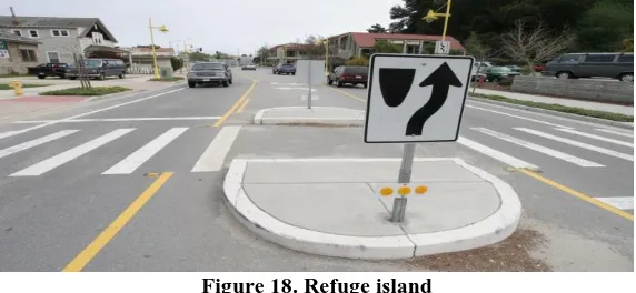
Refuge islandsRefuge islands are brought medians put up in the focal point of the roadway at midblock areas. Asylum islands are expected to help people on foot in going across wide lanes by giving a protected "shelter" in the focal point of the street, enabling walkers to cross each course of traffic in turn. The nearness of an asylum island lessens the time a person on foot must sit tight for a satisfactory hole in the rush hour gridlock
[image:16.595.155.441.305.437.2]stream and diminishes the intersection separation that they should look at once. The person on foot asylum islands are especially appropriate close to walker generators, for example, medical clinics, schools, shopping centres, and so forth., and may shape some portion of a bigger road scratching plan.
Figure 18. Refuge island
(Source:http://www.tcat.ca/wp-content/uploads/2016/07/pedrefugeilsand.jpg )
Kerb Extensions:
Kerb augmentations "expand" the walkway or control line at explicit focuses to decrease the width of the voyaged part of the roadway or reach out into the divided apportioned for curb side stopping. Kerb augmentations decrease the separation people on foot need to walk, henceforth walkers require littler holes in rush hour gridlock so as to cross and person on foot
delays are probably going to be shorter. Kerb expansions can give a shelter to walkers, improve the sight separation and sightlines for the two people on foot and drivers, and may likewise be considered as a traffic quieting measure.
Figure 19. Kerb extension
(Source:http://www.roadsafety/wp-content/uploads/2016/07/ pedrefugeilsand.jpg)
Raised Crosswalk:
A raised crosswalk is a marked pedestrian crossing point at an intersection or mid-block
[image:16.595.121.477.545.729.2]roadway. The raised surface improves drivers’ awareness of the potential for pedestrians and has a traffic calming effect as one of its effects is to reduce speed. Raised crosswalk
[image:17.595.121.478.96.257.2]applications should be considered within the context of the road authority’s traffic calming policies and practices.
Figure 20. Raised crosswalk
(Source:http://wp-content/uploads/2016/07/pedrefugeilsand.jpg)
Pedestrian Warning Signs:
Warning signs are utilized to alarm drivers to peril or potential risk ahead. They show a requirement for the additional alert by street clients and may require a decrease in
speed or another move. This segment contains counsel on when to utilize each sign. Satisfactory admonition signs can significantly aid street wellbeing. To be best, nonetheless, they ought to be utilized sparingly.
Figure 21. Pedestrian warning signs
(Source:http://warningsign/uploads/2016/07/pedrefugeilsand.jpg)
REFERENCES
1. Thomas, B., & De Robertis, M. (2013). The safety of urban cycle tracks: A review of the literature. Accident Analysis and Prevention, 52, 219–227. https://doi.org/10.1016/j.aap.2012.12.017
2. Wegman, F., Zhang, F., & Dijkstra, A. (2012). How to make more cycling good for road safety? Accident Analysis and Prevention, 44(1), 19–29. https://doi.org/10.1016/j.aap.2010.11.010
3. Baxter, R., Hastings, N., Law, a., & Glass, E. J. . (2008). [ No Title ]. Animal Genetics, 39(5), 561–563.
4. Meschik, M. (2012). Reshaping City Traffic Towards Sustainability Why Transport Policy should Favor the Bicycle Instead of Car Traffic. Procedia - Social and Behavioral Sciences, 48, 495–504. https://doi.org/10.1016/j.sbspro.2012.06.1028
5. Lakes, T., Brückner, M., & Krämer, A. (2014). Development of an environmental justice index to determine socio-economic disparities of noise pollution and green space in residential areas in Berlin. Journal of
Environmental Planning and Management, 57(4), 538–556. https://doi.org/10.1080/09640568.2012.755461
6. Laußmann, D., Haftenberger, M., Lampert, T., & Scheidt-Nave, C. (2013). Soziale Ungleichheit von Lärmbelästigung und Straß enverkehrsbelastung: Ergebnisse der Studie zur Gesundheit Erwachsener in Deutschland (DEGS1). Bundesgesundheitsblatt - Gesundheitsforschung - Gesundheitsschutz, 56(5–6), 822–831. https://doi.org/10.1007/s00103-013-1668-7
7. Pucher, J., Dill, J., & Handy, S. (2010). Infrastructure, programs, and policies to increase bicycling: An international review. Preventive
Medicine, 50(SUPPL.), S106–S125.
https://doi.org/10.1016/j.ypmed.2009.07.028
8. Rutter, H., Cavill, N., Racioppi, F., Dinsdale, H., Oja, P., & Kahlmeier, S. (2013). Economic impact of reduced mortality due to increased cycling. American Journal of
[image:17.595.102.495.342.589.2]Non-Motorized Transport (NMT) User Safety Guidelines in Urban Areas of Developing Countries
https://doi.org/10.1016/j.amepre.2012.09.053
9. MANIRUZZAMAN, K. M., & MITRA, R. (2005). Road Accidents in
Bangladesh. IATSS Research, 29(2), 71–73.
https://doi.org/10.1016/S0386-1112(14)60136-9
10. Organization. P. A. H. (n.d.). REPORT ON ROAD SAFETY IN THE REGION OF THE Report on Road Safety in the Region of the Americas.
11. Keuken, M., Sanderson, E., Van Aalst, R., Borken, J. & Scheider, J. (2005), Contribution of Traffic To Levels of Ambient Air Pollution In Europe. In: Krzyzanowski, M., Kuna-Dibbert, B. & Schneider, J. (Eds.), Health Effects of Transport-Related Air Pollution. Copenhagen, World Health Organization, 53-84.
12. Wegman, F., & Dijkstra, A. (1988). Safety Effects of Bicycle Facilities: the Dutch Experience. International Road and Traffic Conference.
13. Division, S. (n.d.). Editorial committee Chairperson. 14. Srinagar development authority (SDA) Draft plan report 2017,
www.sda.gov.in
AUTHORSPROFILE
The first author is Adinarayana. Badveeti was conceived in Sanikavaram (Vi), Prakasam (Dist), Andhra Pradesh in 1992. He got a B.Tech degree in Civil Engineering from the University of JNTUK, Andhra Pradesh in 2013 and a M.Tech degree in Transportation Engineering from the University of JNTUH in 2015. He is currently working as Ph.D. (Research scholar) in Transportation Engineering and Planning Division, Civil Engineering Department from the National Institute of Technology (NIT), Srinagar, Jammu and Kashmir, India.
The second author is Professor in Civil Engineering Department in National Institute of Technology Srinagar, India and is head of Transportation Engineering and Planning Division. He is actively involved with research work in the area of Pavement materials, Traffic engineering and has several publications in the area of HMA and WMA pavements.