This is a repository copy of Using meteorological normalisation to detect interventions in air quality time series.
White Rose Research Online URL for this paper: http://eprints.whiterose.ac.uk/138077/
Version: Accepted Version
Article:
Grange, Stuart K. orcid.org/0000-0003-4093-3596 and Carslaw, David C.
orcid.org/0000-0003-0991-950X (2018) Using meteorological normalisation to detect interventions in air quality time series. Science of The Total Environment, 653. pp. 578-588.
Reuse
This article is distributed under the terms of the Creative Commons Attribution (CC BY) licence. This licence allows you to distribute, remix, tweak, and build upon the work, even commercially, as long as you credit the authors for the original work. More information and the full terms of the licence here:
https://creativecommons.org/licenses/
Takedown
If you consider content in White Rose Research Online to be in breach of UK law, please notify us by
Using meteorological normalisation to detect interventions in
air quality time series
Stuart K. Grangea,∗, David C. Carslawa,b
a
Wolfson Atmospheric Chemistry Laboratories, University of York, York, YO10 5DD, United Kingdom
b
Ricardo Energy & Environment, Harwell, Oxfordshire, OX11 0QR, United Kingdom
Abstract
Interventions used to improve air quality are often difficult to detect in air quality 1
time series due to the complex nature of the atmosphere. Meteorological normalisation 2
is a technique which controls for meteorology/weather over time in an air quality time 3
series so intervention exploration (and trend analysis) can be assessed in a robust way. 4
A meteorological normalisation technique, based on the random forest machine learning 5
algorithm was applied to routinely collected observations from two locations where known 6
interventions were imposed on transportation activities which were expected to change 7
ambient pollutant concentrations. The application of progressively stringent limits on the 8
content of sulfur in marine fuels was very clearly represented in ambient sulfur dioxide (SO2) 9
monitoring data in Dover, a port city in the South East of England. When the technique was 10
applied to the oxides of nitrogen (NOx and NO2) time series at London Marylebone Road (a 11
Central London monitoring site located in a complex urban environment), the normalised 12
time series highlighted clear changes in NO2 and NOxwhich were linked to changes in primary 13
(directly emitted) NO2 emissions at the location. The clear features in the time series were 14
illuminated by the meteorological normalisation procedure and were not observable in the 15
raw concentration data alone. The lack of a need for specialised inputs, and the efficient 16
handling of collinearity and interaction effects makes the technique flexible and suitable for a 17
range of potential applications for air quality intervention exploration. 18
Keywords:
1. Introduction
19
Across all spatial and temporal scales, weather influences concentrations of atmospheric 20
pollutants and in turn ambient air quality (Stull, 1988; Monks et al., 2009). The effects 21
of weather (or meteorology) on air quality are often much greater than intervention or 22
management efforts to control air pollution and therefore intervention events can be very 23
difficult to detect and quantify within an observational record (Anh et al., 1997). Similarly, 24
when considering trends in ambient air pollution, it can be difficult to know whether a 25
change in concentration is due to meteorology or a change in emission source strength. 26
Meteorological variation can therefore frustrate the analysis of trends in different pollutant 27
species. If meteorology is not controlled or accounted for, the changes in pollutant concentra-28
tions observed may be contaminated with meteorological variation rather than emission or 29
chemically induced perturbations which can lead to erroneous conclusions concerning the 30
efficacy of air quality management strategies (Libiseller et al., 2005; Wise and Comrie, 2005). 31
This issue is often acknowledged, but infrequently addressed. 32
Meteorological normalisation is one technique which can be used to control for meteorology 33
over time in air quality time series. The central philosophy of meteorological normalisation 34
is to reduce variability in an air quality time series with statistical modelling. The reduction 35
of variability is achieved by training a model which can explain some of the variation of 36
pollutant concentrations through a number of independent variables. The independent 37
variables used are typically surface-based meteorological observations and time variables 38
which act as proxies for regular emission patterns such as hour of day and season (Derwent
39
et al.,1995). However, in practice, any independent variable which could explain variations 40
in pollutant concentrations could be used. Once the model has been trained and it is found 41
that it can explain an adequate amount of the dependent variable’s variation, the model can 42
be used to remove the influence the independent variables have on the dependent variable 43
by sampling and predicting. The time series which results can then be exposed to further 44
exploratory data analysis (EDA) techniques such as formal trend analysis and/or intervention 45
∗Corresponding author
exploration (Grange et al., 2018). The normalised time series is in the pollutant’s original 46
units and can be thought of as concentrations in “average” or invariant weather conditions. 47
There has been some air quality research conducted which uses the idea of change-point 48
analysis to investigate changes in atmospheric pollutant concentrations (for exampleCarslaw
49
et al., 2006; Carslaw and Carslaw, 2007). Methods such as these rely on regime changes 50
where a time series abruptly shifts from one regime to another (Lyubchich et al., 2013). 51
In the air quality domain, this rarely happens, since changes are usually nuanced and 52
occur progressively with much variability which makes the generality of this approach for 53
investigating intervention efforts poor. Meteorological normalisation is potentially a more 54
general approach which enables its use in a greater range of applications. 55
Atmospheric processes are complex, non-linear, and observations commonly record 56
collinearity with other observations. These attributes make the process of statistical mod-57
elling very challenging, especially so with parametric methods (Barmpadimos et al.,2011). 58
With the rise of machine learning algorithms, these attributes can be much more easily 59
accommodated due to the non-parametric and robust nature of these techniques (Friedman
60
et al., 2001). The meteorological normalisation technique used here uses random forest, an 61
ensemble decision tree machine learning method as the modelling algorithm. 62
Random forest has been described very well and in depth elsewhere (see Breiman, 2001; 63
Friedman et al., 2001;Tong et al., 2003;Ziegler and K¨onig, 2013; Jones and Linder, 2015; 64
Grange et al., 2018). However in brief, a single decision tree is formed from a series of 65
binary splits which results in homologous or “pure” groups. The splitting process is recursive 66
which means splitting occurs until purity is achieved if the tree is allowed to grow to its 67
maximum depth. Decision trees make no assumptions on the input data structure (they 68
are non-parametric), allow for interaction and collinearity among variables, and will ignore 69
variables which are irrelevant to the dependant variable (Ziegler and K¨onig, 2013). Decision 70
trees are fast to train, fast to make predictions, and are conceptually simple to understand. 71
However, they suffer heavily from overfitting, an issue where the model represents the training 72
set well, but does not generalise to sets which were not used for training (Jones and Linder, 73
would result in the model being contaminated with noise from the training set and unreliable 75
predictions would impede analyses. 76
Random forest is an algorithm which controls for the tendency of decision trees to overfit. 77
The algorithm achieves this by sampling (with replacement) the training set with a process 78
called bagging (bootstrap aggregation) (Breiman, 1996). In modern usage, sampling of the 79
independent variables is usually done during bagging too. Bagging results in a new, sampled 80
set called out-of-bag (OOB) data. A decision tree is then grown on the OOB data. The 81
bagging-then-tree growth is repeated, generally a few hundred times. Because OOB data is 82
sampled, all the decision trees are grown on differing observations and independent variables 83
which leads to a “forest” of decorrelated trees. After training, all the individual trees within 84
the forest are used to predict, but their predictions are aggregated as a mean (or the mode 85
for categorical dependent variables) and that forms the single ensemble prediction for the 86
model. 87
The meteorological normalisation technique is pragmatic in respect to the input variables 88
required for many common applications. Generally, routinely accessible surface meteorological 89
variables are very effective for the process and specialised or obscure variables are generally 90
not necessary for the technique to be applied. Although traffic counts, upper air data, 91
and outputs from weather models will usually strengthen a model’s explanatory power, the 92
existence or access to such variables is not a prerequisite, an attribute which is very useful 93
for most situations where such inputs are not available. For pollutants which are primarily 94
controlled by regional scale processes, most notably particulate matter (PM) and ozone 95
(O3), additional variables such as boundary layer height, air mass cluster, or back trajectory 96
information would however be beneficial to include if possible and examples can be found 97
elsewhere, for exampleGrange et al. (2018). 98
The temporal variables used as independent variables in the meteorological normalisation 99
models: Julian day, weekday, and hour of year are included not for their direct influence on 100
atmospheric concentrations, but because they act as proxies for cyclical emission patterns. 101
Hour of day for example offers a term to explain emissions with a diurnal cycle such as 102
term which represents emissions or atmospheric chemistry which varies seasonally. These 104
processes are generally strong drivers of concentrations of most atmospheric pollutants 105
(Henneman et al., 2015). Random forest’s ability to handle collinearity and interaction 106
between these and the other independent variables used and the lack of need of specialised 107
or exotic inputs results in a flexible tool kit for probing the influences of interventions on air 108
quality time series. 109
1.1. Objectives
110
The primary objective of this paper is to apply a meteorological normalisation technique 111
based on random forest, a machine learning algorithm to detect interventions in air quality 112
monitoring data. This is done to gain understanding of what physical and chemical processes 113
are driving ambient pollutant concentrations and highlight the suitability and potential of 114
the technique to other applications. 115
Two case studies are presented using routine data sets in Dover, South East England 116
where sulfur fuel limits of ships were imposed and changes in ambient sulfur dioxide (SO2) 117
concentrations are expected and in Central London where congestion charging and local bus 118
fleet management has perturbed oxides of nitrogen (NOx) emission sources. The changes in 119
concentrations and emissions are then explained in respect to implementation of policy which 120
would be difficult to detect with other EDA techniques where no meteorological normalisation 121
is performed. 122
2. Methods
123
2.1. Data
124
2.1.1. Port of Dover SO2 125
Hourly SO2 concentrations were analysed from the Port of Dover, a major port located in 126
Kent in the South East of England. Two air quality monitoring sites, Dover Docks and Dover 127
Langdon Cliff’s SO2 data were queried from the Kent Air Quality database (Ricardo Energy 128
& Environment,2018). A nearby meteorological site, Langdon Bay located to the west of 129
NOAA’s Integrated Surface Database (ISD) (NOAA,2016) (Figure1(a)). The monitoring 131
sites had different commissioning and decommissioning dates and neither site is still operating 132
(Table 1). SO2 observations are available between March 2001 and December 2012. The 133
data capture rates for SO2 at Dover Langdon Cliff and Dover Docks for their online period 134
were 92 and 82 % respectively. These monitoring sites are of interest because marine fuels 135
in British and European waters have been subject to a series of sulfur content fuel limits. 136
The introduction and continued enforcement of these sulfur fuel limits were expected to 137
influence ambient SO2 concentrations. The details of these interventions are discussed further 138
[image:7.595.62.541.348.435.2]in Section 3.1.2. 139
Table 1: Details of the air quality monitoring sites in Dover and London used in this analysis. Sites without
end dates are still operational.
Location Site name Site type Latitude Longitude Elevation Date start Date end
Dover Langdon Bay Meteorological 51.133 1.350 117 1973-03-08
Dover Dover Langdon Cliff Urban background 51.132 1.339 98 2001-03-17 2010-03-05
Dover Dover Docks Urban industrial 51.127 1.336 6 2006-11-17 2013-01-03 London London Heathrow Meteorological 51.478 -0.461 25 1948-12-01
London London Marylebone Road Traffic 51.523 -0.155 35 1997-01-01
2.1.2. London Marylebone Road NO2 and NOx
140
Hourly NO2 and NOx data from London’s Marylebone Road air quality monitoring site 141
were accessed from smonitor Europe, a European database containing the observations 142
and metadata from the AirBase and Air Quality e-Reporting (AQER) repositories (Grange, 143
2016, 2017). NOx concentrations have been monitored since July 1997 and the final year of 144
reporting sourced from the European data repositories used was 2016. Data capture rates for 145
NOx and NO2 for the analysis period were 97 %. London Heathrow, a large airport located 146
at the far west of Greater London was used for surface meteorological observations sourced 147
from NOAA’s ISD (Figure 1(b)). London Marylebone Road is situated in a complicated 148
central urban environment. The site is located one metre south of the kerb on the A501 149
trunk road and sits within an irregularly shaped street canyon. London Marylebone Road is 150
●
●
London Heathrow
London Marylebone Road
0km 5km 10km (b) Greater London
●
●
●
Langdon Bay
Dover Langdon Cliff
Dover Docks
Dover Castle Complex
Port of Dover
0km 0.2km 0.4km
(a) Dover
● ●
London
[image:8.595.99.495.120.662.2]Dover
Figure 1: Maps of the study sites with a United Kingdom insert for country-scale context. The Port of Dover
complex is displayed in (a) and the internal lines indicate roads and Greater London is shown in (b), with
pollutants which are monitored at the site (Jeanjean et al., 2017). 152
NOx and NO2 concentrations across European cities are a significant issue and many 153
member states are non-compliant to the legal European ambient air quality limits (Weiss
154
et al., 2012; Grange et al., 2017). Almost all locations which are non-compliant are classified 155
as roadside (or ‘traffic-influenced’) (European Environment Agency, 2016). London has some 156
of the highest roadside concentrations of NOx and NO2 in Europe and London Marylebone 157
Road (Figure 1(b)) is an often referenced monitoring site for its high concentrations. 158
To combat the issue of traffic congestion, Greater London authorities imposed the 159
Congestion Charge Zone (CCZ), which was first enforced in February 2003 (Atkinson
160
et al., 2009). Since that time, the London Low Emission Zone (LEZ), and the Emissions 161
Surcharge (better known as the T-Charge) have also been implemented to combat air pollution 162
(Transport for London, 2018). The details and start dates of these various measures are 163
displayed in Table 2. All these interventions are significant investments with large amounts 164
[image:9.595.65.567.441.551.2]of planning and resources to execute and maintain. 165
Table 2: Details of interventions within Greater London to counter traffic congestion.
Name Abbreviation Start date Area covered Operation
Congestion Charge Zone CCZ 2003-02-17 Central London 07:00–18:00 Mo-Fr
London Low Emission Zone (first phase) LEZ 2008-02-04 Greater London 24/7
London Low Emission Zone (second phase) LEZ 2012-01-03 Greater London 24/7
Emissions Surcharge T-Charge 2017-10-23 Central London 07:00–18:00 Mo-Fr
Ultra Low Emission Zone (planned) ULEZ 2019-04-08 Central London 24/7
2.2. Modelling and the hyperparameters
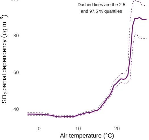
166
For both examples, the meteorological normalisation procedure was conducted in the 167
same way and thermweather R package (version 0.1.2) was used for this process (R Core
168
Team, 2018; Grange, 2018). The number of trees for the random forest models was fixed at 169
300, the minimal node size was five, and the number of variables split at each node was the 170
default for regression mode: the rounded down square root of the number of independent 171
min node size, and mtry respectively). The independent variables used were: Unix date
173
(number of seconds since 1970-01-01) as the trend term, Julian day as the seasonal term, 174
weekday, hour of day, air temperature, relative humidity, wind direction, wind speed, and 175
atmospheric pressure. Training was only conducted on observations which had non-missing 176
wind speed and the pollutant being modelled. Three hundred predictions were used to 177
calculate the meteorologically normalised trend. The normalised trends were aggregated 178
to monthly resolution for presentation in Section 3. A conceptual representation of the 179
meteorological normalisation processes is displayed in FigureA1. 180
For the Dover SO2 examples, models were calculated using the full observational set, but 181
after investigating the models (discussed in Section3.1.1), the observations were filtered to 182
wind directions which were sourced from the port and these models are the ones which were 183
used for the time series analysis (Section 3.1.2). For observations at London Marylebone 184
Road, no filtering was undertaken. In the case of London Marylebone Road, there are a large 185
number of potential events which could influence pollutant concentrations and emissions. 186
To objectively identify events, the meteorologically normalised time series were tested for 187
breakpoints or changes in structure. The structural change algorithm is described in Zeileis
188
et al. (2002);Zeileis et al. (2003) and was implemented with thestrucchange R package. 189
The random forest algorithm does not directly offer the ability to determine error or 190
uncertainty of estimates. However, uncertainty is important to consider in many situations. 191
To enable uncertainty to be evaluated for the case studies, 50 random forest models were 192
grown for each example with the hyperparameters described above, but with randomly 193
sampled (bootstrapped) input sets. The bootstrapping of the observational data ensured 194
the models were grown on different training sets. The importance values (a measure of the 195
variables’ strength or influence on prediction), partial dependencies, and predictions for each 196
of the 50 models were then summarised. The summaries used from the “ensemble of the 197
ensembles” were the mean, and the 2.5 % and 97.5 % quantiles of the 50 estimates i.e. a 198
range that spans the 95 % confidence interval in the mean. The model performance statistics 199
Table 3: Mean random forest model performance statistics four the four sets of models grown for the analysis.
Location Model n R2
Dover Dover Docks SO2 34224 0.67
Dover Dover Langdon Cliff SO2 53535 0.63 London London Marylebone Road NO2 131677 0.82 London London Marylebone Road NOx 131677 0.83
3. Results and discussion
201
3.1. Port of Dover SO2 202
3.1.1. Models
203
The random forest models grown for SO2 at the two Dover sites had R2 values of 63 and 204
67 % (Table 3), therefore, the models had moderate explanatory ability for Dover’s SO2 205
concentrations. However, it should be noted that predicting concentrations over such short 206
time periods with intermittent source strength is challenging and data capture was less than 207
ideal for these monitoring sites. The moderate performance can be explained by SO2 at this 208
location containing large amounts of variation due to ship movements and if winds were in a 209
favourable direction to transport emissions from the port complex to the monitoring sites 210
(southerlies). Indeed, wind direction was the most important variable for SO2 explanation 211
for the random forest models (Figure 2). 212
Partial dependence plots of decision tree models allow the learning process to be interpreted 213
and a data user to examine how variables are being handled in the predictive model. Figure3
214
demonstrates a two-way partial dependence plot for SO2 concentrations at Dover Landon 215
Cliff using wind direction and date (the trend term) as the independent variables. The 216
feature which is most clear is the band of increased SO2 dependence between 150 and 217
210 degrees. Outside of this band of southerly winds, there were low levels of dependence 218
on SO2 concentrations. The Dover Landon Cliff monitoring site was located north of the 219
Port of Dover docks and very slightly to the east (Figure 1(a)). The partial dependence 220
●
●
●
● ●
●
●
●
Error bars are 2.5 and 97.5 % quantiles Weekday
Hour of day Relative humidity Atmospheric pressure Wind speed Julian day Air temp. Wind dir.
0 100 200 300 400
Variable importance (permutation difference)
V
ar
iab
[image:12.595.160.426.116.342.2]le name
Figure 2: Variable importance plot for SO2 at Dover Langdon Cliff between 2001 and 2010 calculated by 50
random forest models.
handled sensibly in the random forest model. This observation can be confirmed further 222
with a bivariate polar plot of mean SO2 concentrations by wind direction and speed at the 223
monitoring site (Figure 4). The first sulfur content fuel change in mid-August 2006 can also 224
be seen in the two-way partial dependence plot as a clear reduction in SO2 dependence when 225
winds were sourced from the port (the south; discussed further in Section 3.1.2; Figure 3). 226
Another clear feature isolated by the partial dependence plots was that SO2 concentrations 227
increased with increasing air temperature at the Dover monitoring sites (Figure 5). This 228
relationship was an unexpected outcome because generally, pollutant concentrations are 229
inversely related to air temperature because emissions are more efficiently diluted during 230
warmer periods owing to increased thermal turbulence. For some sources such as heating, 231
emissions are greater at lower temperatures, but when considering shipping emissions, 232
this would be negligible. At Dover, the SO2 relationship between concentrations and air 233
temperatures was indicative of convective thermal mixing being an important physical process 234
which resulted in SO2 emitted by ships to be mixed towards the measurement site at the 235
0 100 200 300
2002 2004 2006 2008 2010
Date
Wind direction (deg.)
0 20 40 60
[image:13.595.160.428.251.532.2]SO2partialdependence(µgm−3)
Figure 3: Partial dependence of wind direction and date on SO2 concentrations at Dover Landon Cliff
between 2001 and 2010. The Dover Landon Cliff monitoring site was located north of the Port of Dover
0 5 10 ws 15 20 25 30 35
W
S N
E
SO2
(µg m−3)
[image:14.595.158.437.109.340.2]10 20 30 40 50 60
Figure 4: Bivariate polar plot of mean hourly SO2concentrations at Dover Landon Cliff between 2001 and
2010. The Dover Landon Cliff monitoring site was located north of the Port of Dover (for a location map,
see Figure1(a)).
the surface and this feature cannot be easily observed in the hourly observational data. The 237
illumination of such physical processes is a major advantage of the random forest algorithm 238
compared to other machine learning methods such as support vector machines (SVM) or 239
artificial neural networks (ANNs) because they do not offer the same amount of model 240
legibility. 241
3.1.2. Influence of sulfur fuel limits on SO2 concentrations 242
Since the early 2000s, there has been a number of increasingly stringent sulfur based fuel 243
limits imposed on ships operating in British and European Union (EU) waters due to their 244
status as Sulfur Emission Control Areas (SECAs) or Emission Control Areas (ECAs). The 245
most important events for sulfur control were implemented on August 11, 2006 and January 246
1, 2010. In August 2006, the MARPOL Annex IV regulations were applied which introduced 247
a 1.5 % sulfur limit on fuel oils used by vessels moving between EU ports (International
248
Maritime Organization, 2005). The pre-August 2006 sulfur content for British vessels has 249
Dashed lines are the 2.5 and 97.5 % quantiles
40 60 80 100
0 10 20
Air temperature (°C)
S
O2
p
a
rt
ia
l
d
e
p
e
n
d
e
n
cy
(
µ
g
m
−
[image:15.595.163.426.280.526.2]3
)
Figure 5: Partial dependence of SO2 on air temperature at Dover Landon Cliff between 2001 and 2010
At the start of 2010 an additional limit was imposed for all vessels at berth where such 251
vessels were required to be operated with maximum fuel sulfur content of 1 %. These changes 252
should be evident in the SO2 time series of the nearby ambient monitoring sites. However, if 253
a time series is plotted, the influence of these changes are subtle and not clear due to the 254
high amounts of variation within SO2 concentrations (Figure 6). 255
0 50 100 150
2002 2004 2006 2008 2010 2012
Date
D
a
ily
S
O2
co
n
ce
n
tr
a
ti
o
n
(
µ
g
m
−
3 )
[image:16.595.90.502.226.512.2]Site name: Dover Docks Dover Langdon Cliff
Figure 6: Daily SO2 concentrations at two monitoring sites in Dover between 2001 and 2012.
The meteorologically normalised SO2 time series for the Dover sites are displayed in 256
Figure 7, after the observations were filtered to wind directions which came for the port, 257
hence the tight 95 % confidence intervals. The dates when changes in sulfur fuel content 258
were implemented are displayed as vertical lines in Figure 7and the influence of sulfur fuel 259
changes are clear (compared with Figure 6). 260
At Dover Langdon Cliff, the monitoring site which was online during the MARPOL 261
1.5 % fuel sulfur limit transition during August 2001 shows the shift in ambient SO2 very 262
1.5 % sulphur fuel
limit
1 % sulphur fuel limit at ber
th Dashed lines are the 2.5and 97.5 % quantiles
0 25 50 75 100
2002 2004 2006 2008 2010 2012
Date
M
e
te
o
ro
lo
g
ica
lly
n
o
rm
a
lise
d
S
O2
(
µ
g
m
−
3 )
[image:17.595.96.507.248.517.2]Site name: Dover Docks Dover Langdon Cliff
Figure 7: Meteorologically normalised SO2concentrations at two monitoring sites in Dover between 2001
and 2012 as calculated by 50 random forest models. The vertical lines show the start dates of when changes
post-fuel change periods were 48 and 26µg m−3 respectively. This difference represented in
264
percentage change is 45 % and the corresponding estimated change in sulfur fuel content was 265
44 %. This extremely good agreement between sulfur content fuel changes and normalised 266
ambient SO2 concentrations suggests that the Port of Dover activities and ship movements 267
remained constant during the transition phase and the source of SO2 at this location was 268
almost exclusively from the port. 269
The second sulfur fuel content change was implemented on January 1, 2010 and this 270
intervention is also clearly displayed in the meteorologically normalised SO2 concentrations 271
of the Dover Docks monitoring site (Figure7). The percentage change in fuel sulfur content 272
was 33 % and the percentage change in ambient SO2 concentrations was 32 %. Like the 273
previous intervention, these two percentage changes match almost exactly, which is somewhat 274
surprising because the intervention was applied only to berthed vessels which would only 275
make up a component of the Port of Dover activities. 276
3.2. London Marylebone Road NOx
277
3.2.1. Models
278
The random forest models of NOx and NO2 at London Marylebone Road performed well 279
and had R2 values of 82 and 83 % respectively (Table 3). This good performance can be 280
explained by hour of day being a very good predictor for traffic flows and therefore emissions 281
at this location for these (mostly) traffic-sourced pollutants (Figure8). The performance of 282
the random forest models would be rather difficult to achieve with dispersion or deterministic 283
models in such a complicated location. For example, the dispersion models evaluated in 284
Carslaw et al.(2013) struggled to represent the street canyon environment, even when traffic 285
information was taken into account. The importance plots for the London Marylebone Road 286
models also show that wind direction is the most important variable to predict NO2 and 287
NOx concentrations. London Marylebone Road is located in a street canyon and is subjected 288
to complex flows, including ventilation, vortices, and leeward accumulation of pollutants, 289
(primarily) dependent on wind direction (Carslaw and Carslaw,2007; Catalano et al.,2016). 290
NO2 concentrations (Figure 8) and this has been noted before at this location (Charron and 292
Harrison,2005;Westmoreland et al., 2007). 293
●
● ●
●
●
●
●
●
Atmospheric pressure Relative humidity Air temp. Wind speed Julian day Weekday Hour of day Wind dir.
0 10000 20000 30000 40000 50000
Variable importance (permutation difference)
V
ar
iab
[image:19.595.160.438.172.396.2]le name
Figure 8: Variable importance plot for 50 NO2 random forest models for London Marylebone Road. The
uncertainty among the importances of the 50 models was very small and therefore the quantiles are not
shown. The importances for the NOx models were very similar.
3.2.2. Changes in primary NO2 294
Using the predictive models for meteorological normalisation results in very clear and 295
almost noiseless meteorologically normalised trends shown in Figure 9. It is immediately 296
clear that NOx and NO2 are not behaving the same way at this monitoring location. This is 297
because of changes in vehicular primary (directly emitted) NO2 during the analysis period 298
(1997–2016) (Carslaw, 2005;Carslaw et al., 2016;Grange et al.,2017). The vertical lines on 299
Figure9show the breakpoints identified by structural change analysis after the meteorological 300
normalisation procedure. 301
NOx concentrations decreased after the introduction of a bus lane adjacent to the 302
monitoring site in 2001 but have remained near constant since the introduction of the CCZ in 303
controls being applied across Europe between 2003 and 2016 (the last year of data in analysis), 305
they have had little effect to NOx at London Marylebone Road. This observation could 306
be, at least partly, explained by the disconnect between laboratory testing and real-world 307
emissions of NOx which become a public issue after the diesel emission scandal in September 308
2015 (Brand,2016;Schmidt, 2016). However, heavy duty vehicles are also very important to 309
consider alongside passenger vehicles at this Central London location (Laybourn-Langton
310
et al., 2016;Greater London Authority, 2017). 311
CCZ introduced
LEZ introduced
Route 18 Euro III −> V
Dashed lines are the 2.5 and 97.5 % quantiles
Vertical lines are detected breakpoints
Bus lane
N
O2
N
Ox
2000 2005 2010 2015
80 90 100 110
300 325 350 375 400
Date
M
e
te
o
ro
lo
g
ica
lly
n
o
rm
a
lise
d
co
n
ce
n
tr
a
ti
o
n
(
µ
g
m
−
[image:20.595.97.509.269.609.2]3 )
Figure 9: Meteorologically normalised NOx and NO2 at London Marylebone Road between 1997 and 2016
as calculated by 50 random forest models (for each pollutant). The vertical lines on show the breakpoints
identified by structural change analysis.
NO2 concentrations at London Marylebone Road have increased since 1997 and were at 312
by changes to the vehicle fleet using the adjacent A501 road resulting from the introduction 314
of congestion charging, London’s Low Emission Zone, and evolution of the local bus fleet. 315
The rapid increase of NO2 concentrations was observed in the meteorologically normalised 316
time series between July 2002 and July 2003 (Figure9). The CCZ was introduced in mid-317
February 2002; right in the middle of the period of increasing NO2 and within six months 318
of the suggested breakpoint (October 2012). The increase in NO2 concentrations was due 319
to increased primary NO2 because no change in the meteorologically normalised NOx was 320
observed at the same time. 321
The implementation of the CCZ was accompanied with a retrofitting programme of 322
Euro III local buses with continuously regenerating diesel particulate filters (CRDPF, also 323
known by their commercial name: CRT filters). CRDPF are passive devices and have two 324
components: an upstream oxidation catalyst and a particulate matter (PM) filter. The 325
oxidation catalyst oxidises NO within the exhaust stream to NO2 and this NO2 is then used 326
as a PM oxidant in the filter-proper. The observations show that these retrofitted passive 327
devices were not optimised because much of the generated NO2 was not reduced within the 328
PM filter and was therefore emitted into the roadside atmosphere and thus significantly 329
increased ambient NO2 concentrations (Figure 9). 330
NO2 concentrations remained approximately stable until February 2008 when London’s 331
Low Emission Zone (LEZ) was introduced and NO2 concentrations began to decrease (Fig-332
ure 9). The second NO2 breakpoint was detected for February 2008 giving some evidence 333
that the LEZ reduced NO2 concentrations at London Marylebone Road (although no corre-334
sponding change in NOx was observed). However, during this period the local bus fleets were 335
also being progressively replaced with newer buses compliant to the later Euro IV, V, and 336
VI heavy vehicle emission standards (Finn Coyle, Tom Cunnington, and Gabrielle Bowden 337
(Transport for London), personal communication, March 2018) as well of natural vehicle 338
turnover removing older and more polluting vehicles from the in-service fleet. The third NO2 339
breakpoint identified coincided with route 18, the bus route with the highest peak vehicle 340
requirements (PVR), shifting from Euro III to Euro V vehicles in late 2010 (Figure9). After 341
buses servicing the 453, 27, and 205 routes. By the end of 2016, NO2 had declined to almost 343
pre-CCZ concentrations. The features displayed in the normalised time series were not clear 344
in the raw concentration data (displayed in FigureA2) and the breakpoints identified were 345
unable to be resolved without the meteorological normalisation technique. 346
The tandem use of the meteorological normalisation procedure and breakpoint analysis 347
is powerful and can revel many changes, but in many cases there may not be sufficient 348
information or metadata to help explain the changes observed. In this Central London 349
example, many of the factors driving pollutant concentrations are known due to the site’s 350
prominence. 351
London Marylebone Road also monitors ozone (O3), something which is rare for roadside 352
monitoring locations in Europe. The NO2, NOx, and O3 complement allows for the estimation 353
of primary NO2 with an independent method by determining the total oxidant (OX; NO2 354
+ O3) within NOx (Jenkin, 2004; Carslaw and Beevers, 2005). Figure 10 shows monthly 355
estimates of the primary NO2 fraction at London Marylebone Road with robust linear 356
regression. Figure10is consistent with Figure9with a rapid increase in primary NO2 during 357
2002 and a reduction, but at a slower rate after 2008 thus further confirming and validating 358
that the trends observed in Figure9 are driven by changes in primary NO2 emissions. The 359
reason why the trend is similar in Figure 10 and Figure 9 is that at this particular site 360
increased emissions of primary NO2 were sufficient to have a measurable effect on ambient 361
concentrations. 362
4. Conclusions
363
Controlling for changes of meteorology is an important component to consider when 364
conducting air quality data analysis over time. A meteorological normalisation technique 365
using random forest was used to investigate interventions in routine air quality monitoring 366
data from two areas. The interventions applied to marine fuel content changes were explored 367
in Dover, a port city in the South East of England and the interventions were represented in 368
the meteorologically normalised time series almost exactly. The non-black box nature of the 369
● ● ● ● ● ● ●● ● ● ● ● ● ●●● ● ● ●● ● ● ● ● ●● ●● ● ● ● ● ● ● ● ●● ● ● ●● ● ● ●● ● ●● ● ● ● ● ● ● ● ● ● ● ● ● ● ● ●● ● ● ● ● ●●● ● ● ● ● ● ● ● ● ● ● ● ● ● ● ● ●● ● ● ● ● ● ● ● ● ● ●● ● ● ●● ● ● ● ● ● ● ● ● ● ● ● ● ● ●●● ● ● ● ● ● ● ● ● ● ●●● ● ● ● ● ● ● ●● ● ● ● ● ● ● ● ●● ● ● ● ● ● ● ● ● ● ● ●● ●● ● ● ● ● ● ● ● ● ● ● ● ●● ● ● ●● ● ● ● ●●● ● ● ● ● ● ● ●● ● ● ● ● ● ● ●● ● ●● ● ● ● ● ●●● ● ● ● ●● ● ●● ● ● ● ● ● ● ● ● ● ● Error bars are SE of slope estimate
10.0% 20.0% 30.0%
2000 2005 2010 2015
[image:23.595.95.505.113.352.2]Date M o n th ly O X N Ox sl o p e
Figure 10: Monthly total oxidant (OX; NO2 + O3) at London Marylebone Road between 1997 and 2016.
Slope and errors were calculated with robust linear regression.
on meteorological variables such as air temperature and wind direction which highlighted 371
the benefit of the technique where physical and chemical atmospheric processes can be 372
illuminated, understood, and explained. 373
In the example of the implementation of congestion charging in Central London, very clear 374
changes in primary NO2 emissions were displayed in the meteorologically normalised time 375
series. The performance of these roadside models was high due to the models’ ability to use 376
wind direction and hour of day very effectively, something which dispersion or deterministic 377
models struggle with when used for modelling street canyon environments. The case studies 378
presented are both examples where there is significant ability to cross check the observed 379
features with available information on changes in the sites’ local environments to validate 380
the outputs. 381
The meteorological normalisation technique is very relevant for exploring the influence 382
of interventions or management activities on local air quality. The combination of a non-383
proxy variables lends the technique to a wide range of air quality data analysis applications. 385
Acknowledgements
386
S.K.G. was supported by Anthony Wild with the provision of the Wild Fund Scholarship. 387
This work was also partially funded by Natural Environment Research Council (NERC) 388
[grant number: NE/N007115/1]. 389
Competing interests
390
The authors declare no competing interest. 391
Highlights
392
• Detecting the influence of air quality interventions is important
393
• Changes in meteorology over time complicates air quality intervention analysis
394
• Meteorological normalisation was applied in two locations to explore interventions
395
• The changes detected in the normalised time series were associated to interventions
396
• The non-black-box nature of the procedure allows for interpretation of results
397
References
398
Anh, V., Duc, H., Azzi, M., 1997. Modeling anthropogenic trends in air quality data. Journal of the Air &
399
Waste Management Association 47 (1), 66–71.
400
URLhttps://doi.org/10.1080/10473289.1997.10464406
401
Atkinson, R., Barratt, B., Armstrong, B., Anderson, H., Beevers, S., Mudway, I., Green, D., Derwent, R.,
402
Wilkinson, P., Tonne, C., Kelly, F., Nov. 2009. The impact of the congestion charging scheme on ambient
403
air pollution concentrations in London. Atmospheric Environment 43 (34), 5493–5500.
404
URLhttp://www.sciencedirect.com/science/article/pii/S1352231009006268
405
Barmpadimos, I., Hueglin, C., Keller, J., Henne, S., Pr´evˆot, A. S. H., Feb. 2011. Influence of meteorology on
406
PM10trends and variability in Switzerland from 1991 to 2008. Atmospheric Chemistry and Physics 11 (4),
407
1813–1835.
408
URLhttp://www.atmos-chem-phys.net/11/1813/2011/
Brand, C., 2016. Beyond ‘Dieselgate’: Implications of unaccounted and future air pollutant emissions and
410
energy use for cars in the United Kingdom. Energy Policy 97, 1–12.
411
URLhttp://www.sciencedirect.com/science/article/pii/S030142151630341X
412
Breiman, L., 1996. Bagging predictors. Machine Learning 24 (2), 123–140.
413
URLhttp://dx.doi.org/10.1007/BF00058655
414
Breiman, L., 2001. Random forests. Machine Learning 45 (1), 5–32.
415
URLhttp://dx.doi.org/10.1023/A:1010933404324
416
Carslaw, D., Apsimon, H., Beevers, S., Brookes, D., Carruthers, D., Cooke, S., Kitwiroon, N., Oxley, T.,
417
Stedman, J., Stocker, J., 2013. Defra Phase 2 urban model evaluation, UK AIR: Air Information Resource.
418
URLhttps://uk-air.defra.gov.uk/library/reports?report_id=777
419
Carslaw, D. C., Aug. 2005. Evidence of an increasing NO2/NOx emissions ratio from road traffic emissions.
420
Atmospheric Environment 39 (26), 4793–4802.
421
URLhttp://www.sciencedirect.com/science/article/pii/S1352231005005443
422
Carslaw, D. C., Beevers, S. D., Jan. 2005. Estimations of road vehicle primary NO2exhaust emission fractions
423
using monitoring data in London. Atmospheric Environment 39 (1), 167–177.
424
URLhttp://www.sciencedirect.com/science/article/pii/S1352231004008775
425
Carslaw, D. C., Carslaw, N., 2007. Detecting and characterising small changes in urban nitrogen dioxide
426
concentrations. Atmospheric Environment 41 (22), 4723–4733.
427
URLhttp://www.sciencedirect.com/science/article/pii/S1352231007002919
428
Carslaw, D. C., Murrells, T. P., Andersson, J., Keenan, M., 2016. Have vehicle emissions of primary NO2
429
peaked? Faraday Discussions 189 (0), 439–454.
430
URLhttp://dx.doi.org/10.1039/C5FD00162E
431
Carslaw, D. C., Ropkins, K., Bell, M. C., Nov. 2006. Change-point detection of gaseous and particulate
432
traffic-related pollutants at a roadside location. Environmental Science & Technology 40 (22), 6912–6918.
433
URLhttp://dx.doi.org/10.1021/es060543u
434
Catalano, M., Galatioto, F., Bell, M., Namdeo, A., Bergantino, A. S., Jun. 2016. Improving the prediction of
435
air pollution peak episodes generated by urban transport networks. Environmental Science & Policy 60,
436
69–83.
437
URLhttp://www.sciencedirect.com/science/article/pii/S1462901116300594
438
Charron, A., Harrison, R. M., Oct. 2005. Fine (PM2
.5) and Coarse (PM2.5−10) Particulate Matter on A
439
Heavily Trafficked London Highway: Sources and Processes. Environmental Science & Technology 39 (20),
440
7768–7776.
441
URLhttp://dx.doi.org/10.1021/es050462i
442
Derwent, R., Middleton, D., Field, R., Goldstone, M., Lester, J., Perry, R., 1995. Analysis and interpretation
of air quality data from an urban roadside location in Central London over the period from July 1991 to
444
July 1992. Atmospheric Environment 29 (8), 923 – 946.
445
URLhttp://www.sciencedirect.com/science/article/pii/135223109400219B
446
Entec, 2010. Defra UK Ship Emissions Inventory—Final Report, doc Reg No. 21897-01.
447
URL https://uk-air.defra.gov.uk/assets/documents/reports/cat15/1012131459_21897_Final_
448
Report_291110.pdf
449
European Environment Agency, 2016. Air quality in Europe — 2016 report. EEA Report. No 28/2016.
450
URLhttp://www.eea.europa.eu/publications/air-quality-in-europe-2016
451
Friedman, J., Hastie, T., Tibshirani, R., 2001. The Elements of Statistical Learning. Data Mining, Inference,
452
and Prediction, 2nd Edition. Vol. 1. Springer series in statistics Springer, Berlin.
453
Grange, S. K., 2016.smonitor: A framework and a collection of functions to allow for maintenance of air
454
quality monitoring data.
455
URLhttps://github.com/skgrange/smonitor
456
Grange, S. K., 2017. Technical note: smonitor Europe. Tech. rep., Wolfson Atmospheric Chemistry
457
Laboratories, University of York.
458
URLhttps://doi.org/10.13140/RG.2.2.20555.49448/1
459
Grange, S. K., 2018.rmweather: Tools to Conduct Meteorological Normalisation on Air Quality Data. R
460
package version 0.1.2.
461
URLhttps://CRAN.R-project.org/package=rmweather
462
Grange, S. K., Carslaw, D. C., Lewis, A. C., Boleti, E., Hueglin, C., May 2018. Random forest meteorological
463
normalisation models for Swiss PM10trend analysis. Atmospheric Chemistry and Physics 18 (9), 6223–
464
6239.
465
URLhttps://www.atmos-chem-phys.net/18/6223/2018/
466
Grange, S. K., Lewis, A. C., Moller, S. J., Carslaw, D. C., Dec. 2017. Lower vehicular primary emissions of
467
NO2 in Europe than assumed in policy projections. Nature Geoscience 10 (12), 914–918.
468
URLhttps://doi.org/10.1038/s41561-017-0009-0
469
Greater London Authority, 2017. London atmospheric emissions inventory (laei) 2013.
470
URLhttps://data.london.gov.uk/dataset/london-atmospheric-emissions-inventory-2013
471
Henneman, L. R., Holmes, H. A., Mulholland, J. A., Russell, A. G., Oct. 2015. Meteorological detrending
472
of primary and secondary pollutant concentrations: Method application and evaluation using long-term
473
(2000–2012) data in Atlanta. Atmospheric Environment 119, 201–210.
474
URLhttp://www.sciencedirect.com/science/article/pii/S1352231015302521
475
International Maritime Organization, 2005. Revised MARPOL Annex VI, annex VI of MARPOL addresses
476
air pollution from ocean-going ships.
URL http://www.imo.org/en/OurWork/Environment/PollutionPrevention/AirPollution/Pages/
478
Air-Pollution.aspx
479
Jeanjean, A. P. R., Buccolieri, R., Eddy, J., Monks, P. S., Leigh, R. J., Mar. 2017. Air quality affected by
480
trees in real street canyons: The case of Marylebone neighbourhood in central London. Urban Forestry &
481
Urban Greening 22, 41–53.
482
URLhttp://www.sciencedirect.com/science/article/pii/S1618866716303740
483
Jenkin, M. E., Sep. 2004. Analysis of sources and partitioning of oxidant in the UK—Part 2: contributions
484
of nitrogen dioxide emissions and background ozone at a kerbside location in London. Atmospheric
485
Environment 38 (30), 5131–5138.
486
URLhttp://www.sciencedirect.com/science/article/pii/S1352231004006193
487
Jones, Z., Linder, F., 2015. Exploratory data analysis using random forests, 73rd annual MPSA conference,
488
April 16-19, 2015, Chicago, United States of America.
489
URLhttps://pdfs.semanticscholar.org/e7b7/3565b07a7f1369a20b1055f222423f0feb34.pdf
490
Laybourn-Langton, L., Quilter-Pinner, H., Ho, H., 2016. Lethal and illegal: Solving london’s air pollution
491
crisis, institute for Public Policy Research.
492
URLhttp://www.ippr.org/read/lethal-and-illegal-solving-londons-air-pollution-crisis
493
Libiseller, C., Grimvall, A., Wald´en, J., Saari, H., 2005. Meteorological normalisation and non-parametric
494
smoothing for quality assessment and trend analysis of tropospheric ozone data. Environmental Monitoring
495
and Assessment 100 (1), 33–52.
496
URLhttp://dx.doi.org/10.1007/s10661-005-7059-2
497
Lyubchich, V., Gel, Y. R., El Shaarawi, A., 2013. On detecting non-monotonic trends in environmental time
498
series: a fusion of local regression and bootstrap. Environmetrics 24 (4), 209–226.
499
URLhttp://dx.doi.org/10.1002/env.2212
500
Monks, P., Granier, C., Fuzzi, S., Stohl, A., Williams, M., Akimoto, H., Amann, M., Baklanov, A.,
501
Baltensperger, U., Bey, I., Blake, N., Blake, R., Carslaw, K., Cooper, O., Dentener, F., Fowler, D.,
502
Fragkou, E., Frost, G., Generoso, S., Ginoux, P., Grewe, V., Guenther, A., Hansson, H., Henne, S.,
503
Hjorth, J., Hofzumahaus, A., Huntrieser, H., Isaksen, I., Jenkin, M., Kaiser, J., Kanakidou, M., Klimont,
504
Z., Kulmala, M., Laj, P., Lawrence, M., Lee, J., Liousse, C., Maione, M., McFiggans, G., Metzger, A.,
505
Mieville, A., Moussiopoulos, N., Orlando, J., O’Dowd, C., Palmer, P., Parrish, D., Petzold, A., Platt, U.,
506
Pschl, U., Prvt, A., Reeves, C., Reimann, S., Rudich, Y., Sellegri, K., Steinbrecher, R., Simpson, D.,
507
ten Brink, H., Theloke, J., van der Werf, G., Vautard, R., Vestreng, V., Ch. Vlachokostas, von Glasow,
508
R., 2009. Atmospheric composition change - global and regional air quality. Atmospheric Environment
509
43 (33), 5268 – 5350.
510
URL http://www.sciencedirect.com/science/article/B6VH3-4X3N46N-1/2/
1db0fa3c5afafc9418ab227802a71755
512
NOAA, 2016. Integrated Surface Database (ISD).
513
URLhttps://www.ncdc.noaa.gov/isd
514
R Core Team, 2018. R: A Language and Environment for Statistical Computing. R Foundation for Statistical
515
Computing, Vienna, Austria.
516
URLhttps://www.R-project.org/
517
Ricardo Energy & Environment, 2018. Kent air quality database.
518
URLhttp://www.kentair.org.uk
519
Schmidt, C. W., Jan. 2016. Beyond a One-Time Scandal: Europe’s Onging Diesel Pollution Problem.
520
Environmental Health Perspectives 124 (1), A19–A22.
521
URLhttp://www.ncbi.nlm.nih.gov/pmc/articles/PMC4710587/
522
Stull, R. B., 1988. An Introduction to Boundary Layer Meteorology. Kluwer Academic Publishers, London.
523
Tong, W., Hong, H., Fang, H., Xie, Q., Perkins, R., Mar. 2003. Decision forest: Combining the predictions
524
of multiple independent decision tree models. Journal of Chemical Information and Computer Sciences
525
43 (2), 525–531.
526
URLhttp://dx.doi.org/10.1021/ci020058s
527
Transport for London, 2018. Driving.
528
URLhttps://tfl.gov.uk/modes/driving/
529
Weiss, M., Bonnel, P., K¨uhlwein, J., Provenza, A., Lambrecht, U., Alessandrini, S., Carriero, M., Colombo,
530
R., Forni, F., Lanappe, G., Le Lijour, P., Manfredi, U., Montigny, F., Sculati, M., Dec. 2012. Will Euro
531
6 reduce the NOx emissions of new diesel cars? — Insights from on-road tests with Portable Emissions
532
Measurement Systems (PEMS). Atmospheric Environment 62, 657–665.
533
URLhttp://www.sciencedirect.com/science/article/pii/S1352231012008412
534
Westmoreland, E. J., Carslaw, N., Carslaw, D. C., Gillah, A., Bates, E., Dec. 2007. Analysis of air quality
535
within a street canyon using statistical and dispersion modelling techniques. Atmospheric Environment
536
41 (39), 9195–9205.
537
URLhttp://www.sciencedirect.com/science/article/pii/S1352231007006863
538
Wise, E. K., Comrie, A. C., Aug. 2005. Extending the Kolmogorov–Zurbenko Filter: Application to Ozone,
539
Particulate Matter, and Meteorological Trends. Journal of the Air & Waste Management Association
540
55 (8), 1208–1216.
541
URLhttp://dx.doi.org/10.1080/10473289.2005.10464718
542
Zeileis, A., Kleiber, C., Kr¨amer, W., Hornik, K., Oct. 2003. Testing and dating of structural changes in
543
practice. Computational Statistics & Data Analysis 44 (1–2), 109–123.
544
URLhttp://www.sciencedirect.com/science/article/pii/S0167947303000306
Zeileis, A., Leisch, F., Hornik, K., Christian, K., 2002.strucchange: An R Package for Testing for Structural
546
Change in Linear Regression Models. Journal of Statistical Software 7 (2), 1–38.
547
URLhttp://www.jstatsoft.org/v07/i02/
548
Ziegler, A., K¨onig, I. R., Dec. 2013. Mining data with random forests: current options for real–world
549
applications. WIREs Data Mining and Knowledge Discovery 4 (1), 55–63.
550
URLhttps://doi.org/10.1002/widm.1114
Appendix
552
Load
Prepare
Split
Train
Normalise
Validate
Trend
estimation
Partial dependence
plots
Training
set
Testing
set
Importance
plots
Other
EDA
Acquire
Evaluate
The meteorological normalisation process
[image:30.595.122.478.143.439.2]Other
summaries
Figure A1: The framework for the meteorological normalisation technique. The training and validation phase
is iterative to ensure the model does not overfit and adequate performance is achieved. After the technique
N O2
N
Ox
2000 2005 2010 2015
0 50 100 150 200 250
0 500 1000
Date
D
a
ily
co
n
ce
n
tr
a
ti
o
n
(
µ
g
m
−
[image:31.595.82.517.226.587.2]3 )
Acquire and load observations
Model with random forest
Clearly detect and explain interventions
Intervention detected Pre-intervention
[image:32.595.67.530.319.482.2]Post-intervention