3D CADASTRE IMPLEMENTATION ISSUES IN
AUSTRALIA
A Dissertation submitted by
Sudarshan Karki
For the award of
Master of Spatial Science Research
3D CADASTRE IMPLEMENTATION ISSUES IN AUSTRALIA iii Increasing pressure on our urban environment has resulted in the development of infrastructure and buildings above and below the surface of the earth. Jurisdictions in Australia and internationally have responded accordingly through the implementation of 3D cadastres. Most jurisdictions have what has been termed a “2D cadastre”, however, “3D cadastre” situations have now created some significant challenges for the existing land administration infrastructure. The Australian implementation of the 3D cadastre is considered one of the best examples amongst other cadastral jurisdictions, however, because of the varying jurisdictional implementation arrangements within Australia, a clear understanding of complex 3D cadastral issues has been difficult to formulate.
The aim of this research is to investigate the institutional and technical issues and characteristics of 3D cadastre developments across Australia and Queensland in particular, to improve the ongoing implementation and developments across jurisdictions. A better understanding of these issues will assist in the identification of areas where future efforts should be focussed. Further, this will assist in highlighting the institutional and technical 3D cadastral implementation issues to be considered by cadastral jurisdictions.
A survey of the eight cadastral jurisdictions of Australia was carried out and the results were analysed to understand the current status of 3D cadastre implementation in Australia. A detailed case study of five cases in the jurisdiction of Queensland was then undertaken to identify specific issues and characteristics of the 3D cadastral implementation. The results were integrated using a mixed methods approach to identify the institutional and technical issues in 3D cadastre and to frame possible strategies to support ongoing implementation of 3D cadastre in Australia.
3D CADASTRE IMPLEMENTATION ISSUES IN AUSTRALIA iv way to 2D rights; however, it was found that 3D data could not be stored in the existing cadastral database as a 3D object. Specific geometrical representations are yet to be finalised, however, the current practice of creating 3D objects through surface triangles has enabled the representation of 3D objects on paper plans. The development of a 3D specific database and the corresponding validation rules in the future will assist in the full implementation of 3D cadastre in Queensland and other jurisdictions.
3D CADASTRE IMPLEMENTATION ISSUES IN AUSTRALIA v I certify that the ideas, experimental work, results, analyses, software and conclusions reported in this dissertation are entirely my own effort, except where otherwise acknowledged. I also certify that the work is original and has not been previously submitted for any other award, except where otherwise acknowledged.
_____________________________ ____________________
Sudarshan Karki, Candidate Date
ENDORSEMENT
_____________________________ ____________________
A/Professor Kevin McDougall, Principal Supervisor Date
3D CADASTRE IMPLEMENTATION ISSUES IN AUSTRALIA vi I would like to gratefully acknowledge the variety of contributions by the people who have made this journey possible. Firstly, my heartfelt and sincere thanks to my supervisors Associate Professor Dr. Kevin McDougall and Dr Rod Thompson. They have both provided exceptional guidance, encouragement, advice and support. Next I would like to thank Dr. Peter van Oosterom of TU Delft for his advice and encouragement.
Professionals at the Department of Natural Resource and Mines, Queensland have supported me during this journey. Although there are a lot of people who I am grateful to, I would like to name only a few due to a lack of space. Dr. Russell Priebbenow, Peter Lennon, Bill Gilder, Lex Irwin, Nev Cumerford, Paul McClelland, Jim Sloan, Steve Tarbit, Ken Cooper, Sudhakar Rapole, and Dave Raphael are some of the names that I would like to mention. I would also take this opportunity to thank all the respondents of the questionnaire sent by the ICSM which was used in my research.
Thanks to Juanita Ryan of USQ for her support and role in liaising between me and the University. My good friend Dev Raj Paudyal provided me with great moral support and encouragement so a special thanks to him. My other friends Govinda Baral, Giriraj Khanal and Bimal Gyawali provided social and moral support during this journey.
3D CADASTRE IMPLEMENTATION ISSUES IN AUSTRALIA vii
ABSTRACT...iii
CERTIFICATION OF DISSERTATION... v
ACKNOWLEDGEMENTS ...vi
TABLE OF CONTENTS ...vii
LIST OF FIGURES ... x
LIST OF TABLES...xii
PUBLICATIONS RELATED TO RESEARCH ...xiii
1 CHAPTER 1: INTRODUCTION ... 1
1.1 BACKGROUND ... 2
1.2 RESEARCH FORMULATION... 3
1.2.1 Statement of Research Problem ... 3
1.2.2 Research Aim ... 4
1.2.3 Research Questions ... 4
1.2.4 Research Objectives ... 5
1.3 RESEARCH APPROACH... 5
1.4 STRUCTURE OF CHAPTERS... 6
1.5 CHAPTER SUMMARY... 8
2 CHAPTER 2: LITERATURE REVIEW... 9
2.1 INTRODUCTION... 10
2.2 CADASTRE... 10
2.3 3DCADASTRAL BACKGROUND... 12
2.4 3DCADASTRE APPLIED TO LAND ADMINISTRATION... 13
2.5 LEGAL FRAMEWORK OF 3DCADASTRE... 14
2.6 3DCADASTRE IN INTERNATIONAL JURISDICTIONS... 16
2.7 REVIEW OF ISSUES IN 3DCADASTRE... 19
2.7.1 3D Geometrical Representation ... 19
2.7.2 Data Modelling and Information Management ... 20
2.7.3 3D Data and Topographic Elevation... 21
2.7.4 Data Validation... 21
2.7.5 Standardisation ... 22
2.7.6 Applications of 3D Cadastre ... 22
2.7.7 Registration of Rights... 23
2.7.8 Legal Rights Similar to Surface Parcels ... 23
2.8 CONCLUSION... 23
3 CHAPTER 3: RESEARCH DESIGN & METHODS ... 25
3.1 INTRODUCTION... 26
3.2 RESEARCH DESIGN FRAMEWORK... 26
3.3 RESEARCH METHODS... 26
3.3.1 Quantitative Methods ... 27
3.3.2 Qualitative Methods ... 27
3.3.3 Mixed Methods... 28
3.4 DATA COLLECTION... 28
3.4.1 Survey ... 29
3.4.2 Case Study ... 31
3.5 DATA INTEGRATION AND INTERPRETATION... 34
3.6 CONCLUSION... 34
4 CHAPTER 4: STATUS OF 3D CADASTRE IN AUSTRALIAN JURISDICTIONS... 36
4.1 INTRODUCTION... 37
3D CADASTRE IMPLEMENTATION ISSUES IN AUSTRALIA viii
4.4.1 Existing 3D Situations... 40
4.4.2 Infrastructure/Utility Networks... 48
4.4.3 Construction/Building Units ... 49
4.4.4 X/Y Coordinates ... 52
4.4.5 Z Coordinates ... 54
4.4.6 Temporal issues ... 55
4.4.7 Rights, Responsibilities and Restrictions (RRR)... 55
4.4.8 Digital Cadastral Database (DCDB) ... 56
4.4.9 Plan of Survey ... 58
4.5 CONCLUSION... 61
5 CHAPTER 5: QUEENSLAND CASE STUDIES ... 62
5.1 INTRODUCTION... 63
5.2 QUEENSLAND OVERVIEW... 64
5.2.1 Legislative Support... 66
5.2.2 Policies, standards, and guidelines... 67
5.2.3 Registration of Tenure... 68
5.2.4 Operational Aspects... 69
5.2.5 Geometrical Aspects... 72
5.2.6 Database Representation ... 73
5.3 CASE STUDIES... 74
5.3.1 Volumetric Encroachment... 78
5.3.2 Volumetric Network Parcels ... 84
5.3.3 Volumetric Ambulatory Boundary ... 90
5.3.4 Volumetric Doughnut... 93
5.3.5 Volumetric Road ... 96
5.4 CONCLUSION...100
6 CHAPTER 6: DISCUSSION...102
6.1 INTRODUCTION...103
6.2 SUMMARY OF FINDINGS...103
6.2.1 Summary of Questionnaire Study ...103
6.2.2 Summary of Case Study ...104
6.3 INTEGRATING THE RESULTS...106
6.3.1 Legislative Support...108
6.3.2 Policy, Standards and Procedure...109
6.3.3 Operational Arrangements ...109
6.3.4 Registration of Rights / Tenure ...109
6.3.5 Geometry ...109
6.3.6 Data Capture and Representation...110
6.4 IMPLEMENTATION STRATEGIES...110
6.4.1 Legislative Support for 3D Cadastral Objects ...111
6.4.2 Creating more comprehensive Policy, Standards and Guidelines...112
6.4.3 Build Industry Skills and Capacity in 3D Cadastre Operations ...113
6.4.4 Registration of 3D Objects...113
6.4.5 Research and Implement a Specific Geometry...114
6.4.6 Build 3D Capable Database ...114
6.5 CONCLUSION...115
7 CHAPTER 7: CONCLUSION AND FUTURE RESEARCH ...116
7.1 INTRODUCTION...117
7.2 RESEARCH AIM AND OBJECTIVES...117
7.2.1 Objective 1: Review Existing Theory and Practice...118
7.2.2 Objective 2: Status of 3D Cadastre in Australian Jurisdictions ...119
7.2.3 Objective 3: Status of 3D Cadastre in Queensland...119
7.2.4 Objective 4: Identification of Issues and Formulating Strategies ...120
7.3 CONTRIBUTIONS OF THIS RESEARCH...121
3D CADASTRE IMPLEMENTATION ISSUES IN AUSTRALIA ix
7.4.3 Validation Strategy for 3D Cadastral data ...122
7.4.4 Visualisation ...122
REFERENCES...123
APPENDIX1:EXAMPLEOFPLANSOFSURVEY ...130
APPENDIX2:QUESTIONNAIRE...133
3D CADASTRE IMPLEMENTATION ISSUES IN AUSTRALIA x
Figure 1-1: Research Approach ... 6
Figure 1-2: Chapter structure of the dissertation ... 7
Figure 2-1: Examples of network parcel registration in Denmark (Stoter, Sorensen & Bodum 2004) 17 Figure 2-2: Example of 3D subsurface parcels on base parcels in Israel, (Benhamu 2006) ... 18
Figure 2-3: Example from the Netherlands, (Stoter & Ploeger 2003a) ... 18
Figure 3-1: Conceptual research design framework... 26
Figure 3-2: Study area for questionnaire survey ... 29
Figure 3-3: Location of case studies ... 32
Figure 3-4: Data sources for case study... 34
Figure 4-1: The eight cadastral jurisdictions of Australia... 38
Figure 4-2: Number of jurisdictions where 3D parcels are not necessarily constrained within 2D base parcels ... 43
Figure 4-3: Example of a 3D lot constrained within a 2D lot ... 44
Figure 4-4: Example of an ambulatory boundary and its 3D representation... 44
Figure 4-5: Number of jurisdictions that register 3D ambulatory boundaries in the cadastre ... 45
Figure 4-6: Example of a single 2D disconnected multi-part lot ... 46
Figure 4-7: Example of multi-part lots in a building format plan... 47
Figure 4-8: Number of jurisdictions that register disconnected 3D parts of a single lot... 47
Figure 4-9: Example of a circular road shown as a series of short straight chords ... 48
Figure 4-10: Curved surface and its corresponding planar polyhedral surface (similar to short chords), Karki et al (2011) ... 48
Figure 4-11: Number of jurisdictions where network parcels are registered... 49
Figure 4-12: Example of a common property inside and outside of a building ... 50
Figure 4-13: Outline of a building (left); details of the building units stored as attributes (right)... 51
Figure 4-14: Example of a survey plan without X/Y coordinates ... 53
Figure 4-15: Example of a 3D plan with Z coordinates ... 54
Figure 4-16: Example of a 3D volumetric plan of survey from Queensland... 59
Figure 4-17: Example of a building format plan showing reference marks (left), and a reference table (right) ... 60
Figure 5-1: Queensland location ... 64
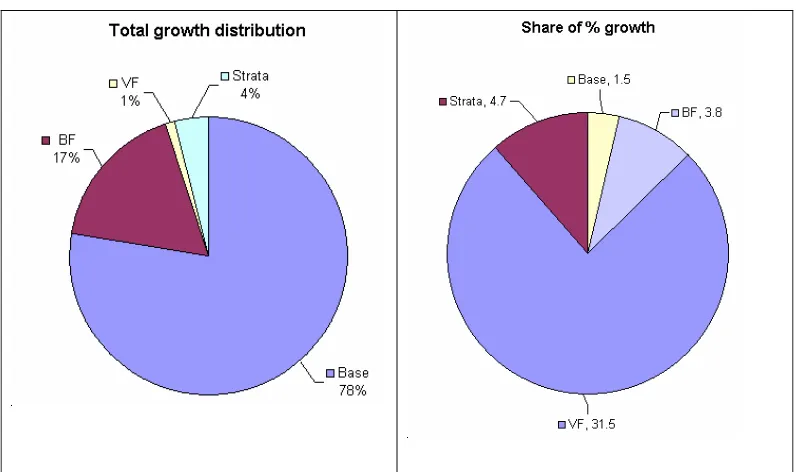
Figure 5-2: (Left) Distribution of total growth in one year, (Right) Share of % growth in each category ... 65
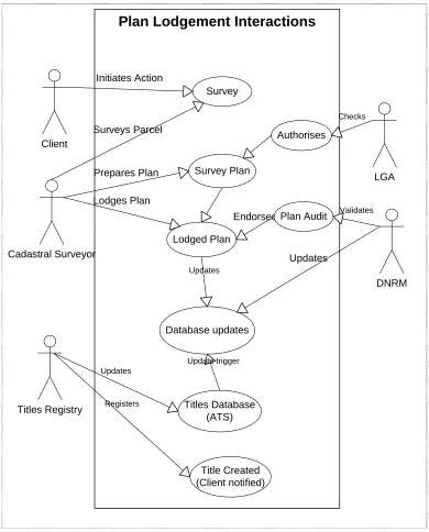
Figure 5-3: Institutional interactions on plan lodgement in Queensland ... 70
Figure 5-4: Institutional interactions within DNRM ... 72
Figure 5-5: Example of a 3D curved surface... 72
Figure 5-6: Location of Case 1: Volumetric encroachment at Woolloongabba Stadium ... 75
Figure 5-7: Location of Case 2: Volumetric network parcels at Woolloongabba Busway... 76
Figure 5-8: Location of Case 3: Volumetric ambulatory boundary at Brisbane River ... 76
Figure 5-9: Location of Case 4: Volumetric Doughnut along Morala Avenue, Gold Coast... 77
Figure 5-10: Location of Case 5: Volumetric Road along Boundary Road, Brisbane City ... 77
Figure 5-11: Google map view of the location of the Gabba Stadium ... 78
Figure 5-12: The Gabba Stadium on Stanley Street overhanging Stanley Street... 79
Figure 5-13: SP134698 creating one of the volumetric lots... 80
Figure 5-14: Isometric drawing of 103/SP134698 creating the volumetric lot ... 82
Figure 5-15: The progression of the Gabba Stadium over time... 83
Figure 5-16: SmartMap view of the DCDB over the Gabba Stadium and surroundings... 84
Figure 5-17: Google Maps view of the location of the Busway and the Tunnel... 85
Figure 5-18: Google Street view from Main Street of the volumetric lots... 85
Figure 5-19: Volumetric Lot 4 on SP149278 (Top) and its isometric view (Bottom) ... 87
Figure 5-20: Volumetric Lot 160/SP184385 of Clem 7 tunnel underneath the busway ... 88
Figure 5-21: Changes to the Woolloongabba busway over time ... 89
Figure 5-22: SmartMap view of the DCDB of the two volumetric lots ... 90
Figure 5-23: Google Map location of the volumetric ambulatory boundary... 91
Figure 5-24: (Top) Plan showing the original 2D ambulatory boundary and, (Bottom) Isometric drawing of the same volumetric ambulatory parcel ... 92
3D CADASTRE IMPLEMENTATION ISSUES IN AUSTRALIA xi
Figure 5-28: (Left) Plan showing the three volumetric lots and their relative vertical position, (Right)
Isometric drawings of the three lots... 95
Figure 5-29: SmartMap view of the data stored in the DCDB of the three volumetric lots... 96
Figure 5-30: Google Map view of the location of the volumetric road in Brisbane ... 97
Figure 5-31: (Left) Volumetric road footprint and (Right) isometric view ... 98
Figure 5-32: (Left) Building format plan, and (Right) Example of layout of units and common property in a level... 98
Figure 5-33: Building Format Plan example with different views and footprint information ... 99
Figure 5-34: SmartMap view of the DCDB for the volumetric road...100
Figure 6-1: Integrating survey and case study...106
3D CADASTRE IMPLEMENTATION ISSUES IN AUSTRALIA xii
Table 2-1: 3D cadastre characteristics of international jurisdictions ... 16
Table 2-2: GIS data models relevant to 3D cadastre, (Benhamu 2006) ... 20
Table 3-1: Structure of questionnaire ... 30
Table 3-2: 3D cadastral cases and their characteristics ... 33
Table 4-1: The framework for discussion... 38
Table 4-2: Statistics relating to cadastral properties, area and population of Australia ... 39
Table 4-3: Legislation to support 3D cadastre... 41
Table 4-4: Software used in DCDB in all jurisdictions... 57
Table 5-1: Discussion framework for analysis of case studies ... 64
Table 5-2: Statistics for 2D and 3D cadastral lots in Queensland taken at August 2011 and August 2012 ... 65
Table 5-3: The core legislative framework of Queensland cadastre... 67
Table 5-4: Guidelines and manuals in Queensland ... 68
Table 5-5: Sample of tenure types in Queensland DCDB... 69
Table 5-6: 3D cadastral cases and a brief description ... 75
Table 6-1: Identification of significant 3D cadastre issues and their source ...107
3D CADASTRE IMPLEMENTATION ISSUES IN AUSTRALIA xiii (1) Karki, S, Thompson, R, & McDougall, K. (2009). Data validation in 3D cadastre In Neutens, T. & Maeyer, P. (Eds.), Developments in 3D Geo-Information Sciences (Vol. Lecture Notes in Geoinformation and Cartography): Springer Berlin Heidelberg.
(2) Karki, S, McDougall, K, & Thompson, R. (2010). An Overview of 3D Cadastre from a Physical Land Parcel and a Legal Property Object Perspective. Paper presented at the FIG Congress 2010, April 11-16, 2010, Sydney, Australia.
www.fig.net/pub/fig2010/papers/ts05a%5Cts05a_karki_mcdougall_et_al_4432.pdf
(3) Karki, S, Thompson, R, McDougall, K, Cumerford, N, & van Oosterom, P. (2011). ISO Land Administration Domain Model and LandXML in the development of digital survey plan lodgement for 3D Cadastre in Australia. Paper presented at the 2nd International Workshop on 3D Cadastres, 16-18 November 2011, Delft, The Netherlands.
http://www.gdmc.nl/3DCadastres/literature/3Dcad_2011_15.pdf
(4) van Oosterom, P, Stoter, J, Ploeger, H, Thompson, R, & Karki, S. (2011). World-wide inventory of the status of 3D Cadastres in 2010 and expectations for 2014. Paper presented at the FIG Working Week 2011, May 18-22, 2011, Marrakech, Morocco.
http://www.fig.net/pub/monthly_articles/may_2011/may_2011_vanoosterom_stoter_et_al.pd f
(5) Karki, S, Thompson, R, & McDougall, K. (2013). Development of Validation Rules to Support Digital Lodgement of 3D Cadastral Plans, Computers, Environment and Urban Systems (Under publication Ms. Ref. No.: CEUS-D-12-00048)
3D CADASTRE IMPLEMENTATION ISSUES IN AUSTRALIA
1
1
CHAPTER 1: INTRODUCTION
CHAPTER 1
3D CADASTRE IMPLEMENTATION ISSUES IN AUSTRALIA
2
1.1 BACKGROUND
With rapid growth of urban environments worldwide, there is an increasing need to develop more innovative and efficient land titling systems to support urban development in our crowded cities. The limited availability of land has necessitated the development of complex infrastructures below and above the ground and the need for the registration of the ownership of this infrastructure. Many countries around the world, including Australia, are now developing and implementing three dimensional (3D) cadastral frameworks to address these situations, but capturing and registering these rights within existing systems brings considerable challenges. As Stoter (2004, p. 3) maintains, “even when the creation of property rights to match these developments is available within the existing legislation, describing and
depicting them within the cadastral registration poses a challenge”.
The conventional two-dimensional (2D) parcel is considered to be a special case of the 3D parcel (Stoter & van Oosterom 2006). The 2D parcel is commonly considered to be the surface or base parcel and is in fact an intersection of a column of space with the earth’s surface (Stoter 2004) usually with an unspecified depth below or height above the surface of the earth. This paradigm shift in considering a parcel from a 2D plan-world view to a 3D column of rights has necessitated the development of a 3D capable system where multi-dimensional rights and restrictions can be visualised and are also capable of being spatially sliced.
3D CADASTRE IMPLEMENTATION ISSUES IN AUSTRALIA
3
To understand the nature of a 3D cadastre it is necessary to understand the different situations in which a parcel or property unit may be considered to be 3D. The cadastre can be considered to consist of two components, a geometrical component and a legal component that covers among other things, the rights, restrictions and responsibilities (RRR). It is necessary to analyse 3D parcels from both a geometrical as well as the legal perspective because both components may not coincide in a 3D situation, such as in the case of a network object like a tunnel.
Therefore, it is important to explore a range of possible 3D cadastre scenarios and classify them according to a defined set of rules so that they can be treated homogenously. This research will help in understanding the problems and factors associated with a 3D cadastre by focussing on the variety of situations where 3D objects have been created. By recognising the various 3D cadastre situations it may be possible to increase the level of standardisation, reduce complexity and hence improve land administration operations.
1.2 RESEARCH FORMULATION
1.2.1 Statement of Research Problem
In its simplest form, cadastral registration consists of storing parcel geometry and its accompanying ownership record. In a 3D situation, because of the often complex geometry of a 3D object, the storage and manipulation of the geometrical data becomes problematic, which may also affect the registration of the rights.
Jurisdictions where the primary concern is apartment or condominium registration, have adopted an approach of storing individual apartments as layers on the 2D surface parcel with 3D descriptions often limited to scanned volumetric plans. However, these approaches cannot be considered to constitute a full 3D cadastre system as the geometry is not stored within the cadastral database, the individual 3D object does not exist in its own right within the cadastral system and the rights of the object are not registered independently.
3D CADASTRE IMPLEMENTATION ISSUES IN AUSTRALIA
4
validation, standardisation, application of 3D cadastre such as 3D city models, disaster management and the overall land administration outcomes.
The implementation of 3D cadastre in different jurisdictions varies considerably and a single solution to satisfy the requirements of all is highly unlikely. The issues need to be understood to a level where they still have significance or impact and then they need to be clustered according to homogeneity. An understanding of the issues in 3D cadastre processes will assist jurisdictions in identifying possible solutions and the development of appropriate implementation strategies.
Therefore, the central research problem for this study is:
“In Australia, although 3D cadastral objects are currently being registered, our
understanding of the complex 3D cadastre issues and the varying jurisdictional
implementation arrangements is incomplete, and is therefore limiting our ability to
implement institutional and technical improvements.”
1.2.2 Research Aim
The research will build on our existing understanding of the issues and characteristics of 3D cadastres across Australian jurisdictions and seeks to identify implementation arrangements that would lead to improved land administration processes in Australia.
The central aim of the research is to:
“Identify the key issues and characteristics that are impacting 3D cadastre
developments across Australia and Queensland in particular, so that strategies for
improving its institutional and technical implementation can be identified.”
1.2.3 Research Questions
Based on the above research problem and the research aim, the following research questions were formulated:
1. What are the institutional and technical issues and characteristics relevant to 3D cadastre implementation?
3D CADASTRE IMPLEMENTATION ISSUES IN AUSTRALIA
5
3. What are the specific issues and characteristics of 3D cadastre in Queensland?
4. How can we formulate implementation strategies to address the identified 3D cadastre issues?
1.2.4 Research Objectives
The following objectives were formulated to answer the research questions and to achieve the research aim:
1. To review the existing institutional and technical issues and characteristics relevant to the implementation of 3D cadastre in Australia and internationally;
2. To study the current status of 3D cadastre across the cadastral jurisdictions of Australia;
3. To undertake a detailed study in one Australian jurisdiction to identify specific institutional and technical issues and characteristics of 3D cadastre implementation; and
4. To frame possible strategies to support the ongoing implementation of 3D cadastre in Australia.
1.3 RESEARCH APPROACH
This research used a mixed methods approach for integrating the results of a questionnaire and case study as shown in Figure 1-1. Quantitative and qualitative data was collected from multiple sources for the questionnaire and the case study.
The research was formulated by providing a background to the topic, identification of the research problem, specifying the aim, objectives, and the research questions. It also included a review of existing literature on 3D cadastre from a land administration and technical perspective to formulate the research questions and an appropriate research methodology.
3D CADASTRE IMPLEMENTATION ISSUES IN AUSTRALIA
6
review. Further detailed analysis based on research objective – 3 and the identified gaps were performed for a single jurisdiction of Queensland. Descriptive statistical analysis of questionnaire data was performed to identify the issues and characteristics of 3D cadastre across the jurisdictions of Australia. Qualitative analysis of case study data of the jurisdiction of Queensland provided an in-depth analysis of the features of 3D cadastre implementation.
Figure 1-1: Research Approach
Finally, the integration of the findings of the questionnaire and the case study was undertaken. Within a mixed method design framework, and by using a triangulation approach, the outputs of questionnaire and case study analysis were consolidated to identify the 3D cadastre issues and to formulate possible future implementation strategies.
1.4 STRUCTURE OF CHAPTERS
The thesis is presented in seven chapters as illustrated in Figure 1-2. The chapters are aligned to answer the research questions and achieve the research objectives.
Questionnaire
Questionnaire data collection
Questionnaire analysis
Identification of issues and characteristics
Case Study
Identification of cases
Analysis of cases
Identification of issues and characteristics
Research Outcomes
Integration of findings
Identification of issues & characteristics
Formulation of implementation strategies
Conclusions and future research
Research Formulation
Formulate aim and objectives
Define research questions
Review of existing theory and practice
3D CADASTRE IMPLEMENTATION ISSUES IN AUSTRALIA
7
Figure 1-2: Chapter structure of the dissertation
Chapter One introduces the research background, formulates the research problem, states the research aim, questions and objectives. Chapter Two reviews the cadastre concepts and international 3D cadastre implementation to highlight the current issues and strategies of 3D cadastre and assists in identification of research gap. Chapter Three specifies the research method and design. It proposes a mixed methods research framework to achieve the research objectives. Chapter Four presents the result of a questionnaire survey, which identifies a range of institutional and technical issues and characteristics of cadastral jurisdictions in Australia. Chapter
Objective #3 Objective #2 Objective #1 Chapter 1 Introduction Background
Research Problem, Aim Objectives, Approach Structure
Chapter 2 Literature Review
3D Cadastre Concepts Review of international
implementations Current and emerging
concepts
Research Design Research Methods
Chapter 3 Research Design and
Methods
Chapter 4 Questionnaire Survey
Chapter 5 Case Study
Survey of Australian Jurisdictions Analysis and Results
Queensland Case Study Analysis and Results
Chapter 6 Discussion
Summary of Findings Synthesis and Analysis Formulating Strategies Objective #4
Chapter 7 Conclusion and Future Research
Conclusions
Research Achievements Significance
3D CADASTRE IMPLEMENTATION ISSUES IN AUSTRALIA
8
Five examines the 3D cadastre issues within a particular jurisdiction, Queensland Australia, in detail and presents the results within a similar analysis framework as the questionnaire. Chapter Six integrates the results of the quantitative and qualitative research to identify key issues and to suggest possible implementation strategies. Chapter Seven is the final chapter and concludes with a discussion on the research achievements based on the research objectives and makes recommendations for future research.
1.5 CHAPTER SUMMARY
3D CADASTRE IMPLEMENTATION ISSUES IN AUSTRALIA
9
2
CHAPTER 2: LITERATURE REVIEW
CHAPTER 2
3D CADASTRE IMPLEMENTATION ISSUES IN AUSTRALIA
10
2.1 INTRODUCTION
This chapter explores the 3D cadastral background, clarifies key 3D cadastre terminology and discusses the role of 3D cadastre in land administration. A review of international jurisdictions provides an overview of 3D cadastre implementation in a global context. Finally, issues relevant to 3D cadastre are discussed and the gap in existing research is identified.
2.2 CADASTRE
The International Federation of Surveyors (FIG) published statement on the cadastre (FIG 1995) states: “A Cadastre is normally a parcel-based and up-to-date land information system containing a record of interests in the land (e.g. rights,
restriction and responsibilities). It usually includes a geometric description of land
parcels linked to other records describing the nature of the interests, and often the
value of the parcel and its improvements. It may be established for fiscal purposes
(e.g. valuation and equitable taxation), legal purposes (conveyancing), to assist in
the management of land and land use (e.g. for planning and other administrative
purposes), and enables sustainable development and environmental protection.”
Effenberg (2001), identifies the purpose of the cadastral systems as being the necessary infrastructure to assist in the management of land and land use, to enable sustainable development and environmental improvement. The cadastral system supports different business systems in the area of land administration including:
Land Tenure Systems – to secure legal rights in land Land Value System – to levy tax on the value of land Land Use Control System – to enable land use planning
Land Development System – to enable regulation of land development
3D CADASTRE IMPLEMENTATION ISSUES IN AUSTRALIA
11
Generally, the land register is textual and handled either by the local courts or a titles office, specifically created to administer the legal transfer of land and maintain appropriate legal instruments. The spatial components of the cadastre are normally under the governance of the jurisdiction’s survey and mapping organisations. These may be separate departments within a single government (Effenberg 2001).
The data stored by these registers as described by Kalantari (2008) are cadastral data, which refers to all data related to value, ownership and use in the land administration subsystems. The spatial unit of the cadastre is the land parcel.
Effenberg (2001) interprets, land parcels to be complex, geometric features with ties to geographical, historical and legal objects. Further he adds, the process of maintaining the cadastral map must ensure the integrity of spatial cadastral data and the ability to integrate the spatial data with other land-related spatial and aspatial data sets. Similarly, Zevenbergen (2004) maintains that the parcel is not a physical reality (man-made or not), but an institutional creation. A parcel is a part of the continuum of the earth that a group of people have decided to treat as an identifiable unit. To a certain extent this can be reflected by the use that is made of it, but ultimately it is the legal rights that certain people have that determine the extent of and the boundaries between two parcels.
McDougall (2006) identifies that the land parcel is usually the smallest land unit capable of title registration and its transfer is managed through the state land administration systems. In Australia, these land parcels are usually very accurately defined by cadastral surveying processes, and subsequent titles are registered and form the basis of property ownership.
3D CADASTRE IMPLEMENTATION ISSUES IN AUSTRALIA
12
The differences in definitions and approaches extend not just to jurisdictions in different countries, but also to different jurisdictions within the same country. Effenberg (2001), discovered that within the jurisdictions of Australia, there is considerable diversity between different DCDBs.
2.3 3D CADASTRAL BACKGROUND
Stoter (2004) contends that from a juridical point of view, cadastral registration always has been 3D. The premise for this reasoning is that, although parcels are represented in 2D, someone with a right to a parcel has always been entitled to a space in 3D. A right of ownership on a parcel relates to a space in 3D that can be used by the owner and is not limited to just the flat parcel defined in 2D without any height or depth.
As society addresses continuing land shortages and resource scarcity, the imperative exists to better manage and plan land use (Kalantari 2008). Pressure on land in urban areas and especially their business centres has led to overlapping and interlocking constructions.
Constructions below or above the surface, such as tunnels and platforms used as foundations for buildings, are also treated as separate objects in a subdivision process, and are capable of being registered as separate real property (Kalantari 2008). The increasing complexity of modern cities suggests that modern land administration systems need an improved capacity to manage the third dimension (Zlatanova & Stoter 2006).
3D CADASTRE IMPLEMENTATION ISSUES IN AUSTRALIA
13
In Queensland, freehold title of a 3D cadastral object is guided by the Land Title Act 1994. Although “in strata” title has existed since the 1960s in Australia, it was only in 1997 that 3D geometry could be represented in the cadastral system of Queensland. 3D parcels have been accommodated in the Queensland cadastre via building parcels, restricted parcels, volumetric parcels and remainder parcels.
Modern day constructions, investments and ownerships, in the form of buildings or infrastructure have been considerable and these have been significant drivers for the registration of 3D objects. Technological developments have been another significant driver because of the enhanced capabilities of storage, depiction, modelling and dissemination. As most traditional cadastral definitions are ‘parcel centric’, the subsequent constructions on them are required to adapt to the parcel centric data models.
Stoter (2004, p. 90) concludes that a 3D cadastre should incorporate the following functionalities:
“register 3D information on rights (what is the space to which the person
with a real right is entitled?) and make this information available in a
straightforward way;
establish and manage a link with external databases containing objects of interest for the cadastre (infrastructure objects, soil pollution areas, forest
protection zones, monuments) and incorporate the location (and other
information) of these objects in the cadastral registration; and
use the information on these objects to support registration tasks, that is, to detect and correct errors in the process of registering and viewing the legal
status of 3D situations.”
2.4 3D CADASTRE APPLIED TO LAND ADMINISTRATION
3D CADASTRE IMPLEMENTATION ISSUES IN AUSTRALIA
14
Dale & McLaughlin (1999) suggests that a modern land administration system should provide appropriate infrastructure, which organises a broad range of social, environmental and economic interests in land to support its core policy of sustainability, while Enemark (2005) asserts that a land administration system is part of the infrastructure that supports the integrated management of land. The main characteristics of land administration is the relationship between land and the rights, which in most jurisdictions is a legally valid one (ISO 19152 LADM 2012).
Dale & McLaughlin (1999) identify that land administration consists of three types of functions: juridical, regulatory, and fiscal, with land information management integral to all three. Enemark (2005) believes land administration systems are now evolving from a focus on the core functions of regulating land use, land tenure and land valuation to an integrated land management paradigm designed to support sustainable development.
In land administration the three key attributes of land are ownership, value and use. The attributes of land administration depends on process, functions and components. Kalantari (2008) lists three processes: determination, recording and dissemination of land information. Similarly, Dale & McLaughlin (1999) categorises three functions of land administration, juridical (for land tenure), regulatory (for land use), fiscal (for land value) as well as four components, which are surveying and mapping, land registration, land valuation and land development.
Modern land cadastres supporting registration are highly sophisticated, and expensive to design, build and manage. Looked at as a whole, they display three-dimensional boundaries: height, width, depth, plus (when we add the text) a fourth dimension of time (how long the interest lasts for) (Wallace & Williamson 2004).
2.5 LEGAL FRAMEWORK OF 3D CADASTRE
3D CADASTRE IMPLEMENTATION ISSUES IN AUSTRALIA
15
From the viewpoint of Cadastre 2014, the legal aspect is a basic characteristic of the cadastre. It is the cadastre which documents the legal situation of the land. Land administration work is fulfilled with the help of the lawfully relevant information extracted from the cadastre (Kaufmann 2004).
Zevenbergen (2004) categorises the types of legal rights that can be distinguished in the legal cadastral domain: ownership rights, derived rights (housing or animal farming), minor rights (easement) and lastly security rights (mortgages).
A standard parcel that is defined in 2D, but implies a 3D column of rights, is a lot (or a collection of lots) that is usually unlimited in height and depth. Stoter (2004, p. 71) identifies four types of parcels with a 3D component:
“building parcels, which are parcels that are generally defined by floors,
walls and ceilings;
restricted parcels, which are parcels restricted in height or depth by a
defined distance above or below the surface or by a defined plane (restricted
easements can also be restricted in height and depth). The boundaries of the
restricted parcels must coincide with the boundaries of the surface parcel;
volumetric parcels, which are parcels that are fully bounded by surfaces and are therefore independent of the 2D boundaries of the surface parcels; and
remainder parcels, which are parcels that remain after a volumetric parcel
or building parcel have been subdivided out of it.”
Pertinent to the land administration, legal and technical aspects of 3D cadastre, Stoter (2004, p. 91) describes the following opportunities arising from the implementation of a 3D cadastre:
“3D registration provides information on the 3D extent of rights, limited
rights and legal notifications and allows integration of 3D information in the
current cadastral geographical data set;
A 3D cadastre will incorporate digital information on 3D situations;
3D CADASTRE IMPLEMENTATION ISSUES IN AUSTRALIA
16
If the exact 3D location of infrastructure constructions is available within the cadastral registration (maintained in databases by holders of these objects),
the cadastre can use this source for certain cadastral tasks e.g. during
clean-up of registration or to sclean-upport other cadastral tasks;
Holders of infrastructure constructions will benefit from a clear registration of the location of infrastructure objects; and
Linking databases containing infrastructure objects with the cadastral
registration can also be used for registering pipelines.”
2.6 3D CADASTRE IN INTERNATIONAL JURISDICTIONS
An understanding of the issues and characteristics of 3D cadastre in various international cadastral jurisdictions assists in understanding the variety of implementation arrangements across jurisdictions. For this study, the following jurisdictions have been briefly reviewed (Table 2-1):
Table 2-1: 3D cadastre characteristics of international jurisdictions
Country Characteristics
Denmark Partial implementation of 3D cadastre, exists in some form
Greece Has identified a lot of 3D issues, but not in the process of implementing 3D cadastre
Israel Significant internal research and development completed and 3D cadastre implemented as an intermediate basis until better solution is presented
Netherlands Significant research work completed and problems identified, partial 3D cadastre implemented
Turkey Many 3D issues, 3D cadastre not yet implemented fully
USA Similar to the Australian federal structure with independent jurisdictions at various levels of implementation of 3D cadastre
3D CADASTRE IMPLEMENTATION ISSUES IN AUSTRALIA
17
intersect surface parcels, easements are created, which fragments the base or surface parcel (Figure 2-1 right).
Tarnby Torv Tunnel in Denmark Surface parcel divided into small fragments for pipeline
Figure 2-1: Examples of network parcel registration in Denmark (Stoter, Sorensen & Bodum 2004)
In Greece, according to Papaefthymiou et al (2004), the possessor of a floor or of a part of a floor, is the sole owner of the floor, including its own external walls, flooring, roof and communal spaces of the floor, The owner has no ownership on the parcel, and the possessor of the ground-floor is the sole owner of the land-parcel and the subsoil. The possessor of the upper floor is the sole owner of the air space, unless the air space has already been transferred to another person.
3D CADASTRE IMPLEMENTATION ISSUES IN AUSTRALIA
18
Figure 2-2: Example of 3D subsurface parcels on base parcels in Israel, (Benhamu 2006)
Significant research has been undertaken in The Netherlands and the findings by Stoter & Ploeger (2003a) identify that 2D parcel rights are columnar, rights of superficies exist, condominium registration is possible, DCDB stores 2D data, spatial querying of 3D objects is not possible and network objects are registered as superficies rights (Figure 2-3).
Figure 2-3: Example from the Netherlands, (Stoter & Ploeger 2003a)
3D CADASTRE IMPLEMENTATION ISSUES IN AUSTRALIA
19
In the USA, according to a study done by van Oosterom et al (2005), owners of land own the attached buildings, stratified rights are possible and usually achieved via leasehold, condominium rights exist, air rights can be sold and numerous cadastral jurisdictions exist with differing record keeping systems.
2.7 REVIEW OF ISSUES IN 3D CADASTRE
2.7.1 3D Geometrical Representation
3D properties have been complex to deal with because there are numerous ways to represent, store and visualise these objects as they may or may not be independent of the surface parcel. Additionally, validation and topology is complex as it depends on the 3D geometry chosen, network and crossing objects are not easily stored in the database, and spatial querying of 3D objects depend on the spatial location, storage and topology in the database
The geometric description of individual land parcels forms the building block of a jurisdiction wide map of parcels known as the cadastral map. For many modern cadastral systems around the world, the individual geometric parcel description, the cadastral map and the legal register of rights and interests, form the information in the database of the cadastral system. In concert with current technology, this cadastral map, and hence the geometry of the land parcel, is increasingly stored and manipulated in digital format (Effenberg 2001).
Karki, McDougall, & Thompson (2010) express that in a 2D cadastre, the most common method of representing a parcel is by bounding polygons, however, in a 3D cadastre there are numerous ways of storing the 3D geometry. The ISO19152 (2012) LADM has five ways of defining a parcel, which can be applied to both the 2D as well as the 3D parcel. The parcel is known as a spatial unit in the ISO standard and the parcel definition includes the point spatial unit, text spatial unit, line spatial unit, polygon spatial unit and topological spatial unit.
3D CADASTRE IMPLEMENTATION ISSUES IN AUSTRALIA
20
and extruding (Ledoux & Meijers 2009). Likewise, visualisation of 3D objects in a front-end tool include: primitive instancing (PI); sweep presentations (SWP); boundary representations (b-Reps); spatial partitioning representations (SPR); and constructive solid geometry (CSG) (Jarroush & Even-Tzur 2004).
2.7.2 Data Modelling and Information Management
Cadastral data modelling is particularly important in the domain of land administration. The modelling of a cadastral system has received special attention focused on the International Joint FIG Commission 7 and COST Action G9 Workshop on Standardisation in the Cadastral Domain in 2004 (Kalantari 2008).
Some of the models that can be utilised to store and manage 3D data are detailed in Table 2-2.
Table 2-2: GIS data models relevant to 3D cadastre, (Benhamu 2006)
Model Characteristics Advantages Disadvantages
Layer Data Model
1. Organising multilayer information in layers rather than by space 2. Includes geospatial
objects from all layers
Easier to discover the multilayer relationships between objects
Dependent on the surface parcel
Multilayer Data Model
Data organised in three layers,
a. Surface, b. Below Surface
c. Above Surface
1. Adaptable to existing data models in GIS systems 2. Permits multi-layer
analyses
3. Preserves current surface cadastre layer
3D objects do not exist in their own right
Object Oriented Database
Data organised on the 3D object level rather than layer structure
1. 3D objects spatial property defined as object
2. Objects assigned spatial and chronological identity numbers Loses the advantages of multi-layered GIS database systems Integrated Database
1. Database linked to one surface cadastral layer
2. 3D objects linked as objects to the surface parcel
1. Surface information organised in multi-layers
2. 3D objects organised at object level
3D CADASTRE IMPLEMENTATION ISSUES IN AUSTRALIA
21
2.7.3 3D Data and Topographic Elevation
Referencing elevation data to define a 3D cadastral object and storing that information in the database is influenced by the topographical surface and linking of the topographic elevation to 2D and 3D parcels. Some of the primary issues relevant to linking topographical elevation data to a cadastral surface parcel include topographic representation (Doner & Biyik 2007), integrating elevation to parcel boundaries (Stoter & Gorte 2003), representing 3D cadastre parcel relative to the surface parcel or relative to the height datum and update frequency of elevation data (Benhamu & Doytsher 2003).
2.7.4 Data Validation
The objective of validation in a 2D/3D cadastral environment is to form a rigorous definition of what is a valid object. It is the process of checking for possible errors in data via pre-defined rules usually before the data is processed or entered into the system. In digital cadastre, the need to validate arises from two simple questions: (i) who owns the particular land or space; and (ii) what is the extent of what is owned. Thus, the major reason to validate is to provide unambiguous answers to these questions (Karki, Thompson & McDougall 2009).
Validation rules in 3D geometry depend on the 3D geometrical representation method, for example, the validation rules for a line based encoding will be different to a polygon based encoding. Thompson (2007) states that, the fact that these particular representations can be rigorously defined and implemented demonstrates that such rigour is feasible, and opens the possibility that all computational representations can be similarly analysed. For a 3D cadastral object, validation is performed to ensure geometric validity, consistency with existing database and valid new content.
Situations that may require validation in a 3D cadastral situation include:
Internal validity of 3D parcels – geometrical validations;
3D CADASTRE IMPLEMENTATION ISSUES IN AUSTRALIA
22
Further processing on the geometry – subdivision, consolidation, easements; and
Entry level validations – includes spatio-temporal aspects, continuity.
2.7.5 Standardisation
Standards are required to identify objects, transactions, relationships between objects and persons, classification of land use, land value and map representations of objects (ISO-Ladm19152 2012).
A significant problem in the cadastral domain is the lack of a shared set of concepts and terminology. International standardization of these concepts (that is, the development of an ontology) could possibly resolve many of these communication problems (Kaufmann 2004).
The need for a nationwide standard is summarised by (McDougall 2006) saying national initiatives in land and property related information have mainly been directed towards coordination of state and territory activities through the development of national policies and standards. In a national land administration structure like Australia, where there are several independent cadastral jurisdictions, a common digital submission effort must address legal and semantic interoperability issues (Kalantari et al. 2005).
Paasch (2004) contends that in order to achieve an increased standardisation of the cadastral domain, it is necessary to classify the legal content of a cadastre, focussing on the right of ownership and restrictions connected with ownership. Thompson (2007) notes that for a geometrical representation, if the standardisation effort is to lead to a position where spatial data can be interchanged without manual intervention, cleaning and correction, a rigorous logic is needed to underpin the standards and support the definition of validity of that data.
2.7.6 Applications of 3D Cadastre
3D CADASTRE IMPLEMENTATION ISSUES IN AUSTRALIA
23
property market (Wallace & Williamson 2004), disaster management, management of sub-surface and above surface infrastructure and input towards 4D cadastre.
2.7.7 Registration of Rights
The legal aspects of a cadastre require the registration and transfer of rights, restrictions and responsibilities related to the parcel. This can become complicated in a 3D cadastre situation because 3D objects may or may not be situated on the parcel or may not be registered in the cadastral register. Problems that need consideration include independence of 3D object from surface parcel, rights of 3D objects crossing the surface parcel, and creating network objects that are considered a single object.
2.7.8 Legal Rights Similar to Surface Parcels
In a conventional 2D cadastre, the land parcel can generally be subdivided or consolidated, easements, and full or partial leaseholds can be created. Similarly, in a 3D cadastre, to facilitate the land market and practical applications, the 3D parcel or 3D object should be able to be subdivided, consolidated and easements created. Other interests in land such as mining rights, water rights, and access rights may be applicable to 3D cadastre as well. In Australia, 3D objects have similar registration rights as the 2D cadastral object.
2.8 CONCLUSION
This chapter has reviewed the 3D cadastral background, international implementation and summarised 3D cadastre issues. A brief review of 3D cadastre implementation in international jurisdictions of Denmark, Greece, Israel, Netherlands, Turkey and USA were carried out. The main characteristics obtained from this review was that similar to the Australian cadastre, registrations of apartments are performed in Denmark, Netherlands, Greece, and USA and 3D ownership rights are transferable. Similarly, base parcels were fragmented when network subsurface parcels were created as in Denmark, Netherlands, and Israel. Different to Queensland, easements were created for registering network objects and air rights could be sold in the USA.
3D CADASTRE IMPLEMENTATION ISSUES IN AUSTRALIA
24
issues was undertaken. It was observed that although there are several methods to define a 3D geometry for 3D object creation and representation, these are not implemented in cadastral jurisdictions because they are still being examined for optimal storage, validation and topological requirements. There are three primary requirements for data validation in 3D cadastre: validating 3D geometry; validation against an existing database; and validating new content. Since most jurisdictions have not adopted a defined geometry type, data validation rules for these are yet to be developed. In the cadastral jurisdictions of Australia, each state has developed its own terminology and processes, which has created issues with standardised efforts such as the national ePlan model (Cumerford 2010). In Australia, 3D cadastre is being implemented; however there is a gap in research in understanding the complex 3D cadastre issues. Therefore, it is necessary to investigate the institutional and technical issues and characteristics of 3D cadastre in Australia and Queensland in particular to improve the current 3D cadastre implementations and developments.
3D CADASTRE IMPLEMENTATION ISSUES IN AUSTRALIA
25
3
CHAPTER 3: RESEARCH DESIGN &
METHODS
CHAPTER 3
3D CADASTRE IMPLEMENTATION ISSUES IN AUSTRALIA
26
3.1 INTRODUCTION
The previous chapter discussed the 3D cadastre research context by establishing a theoretical framework, defining key terminology, and identifying the current institutional and technical issues in the implementation of 3D cadastre.
3.2 RESEARCH DESIGN FRAMEWORK
In Chapter Two, a review of the current status of 3D cadastre and the international context was undertaken. In Chapter One, the research questions and objectives were formulated. The first research question was to assist in determining the current status of the development of 3D cadastre. The second research question was primarily quantitative in nature, while the third was mainly qualitative. Thus, within the framework of the mixed methods approach, both qualitative and quantitative data collection methods will be utilised. Figure 3-1 illustrates the research design framework that is suitable for addressing the research questions to achieve the objectives of this research.
Figure 3-1: Conceptual research design framework
3.3 RESEARCH METHODS
This section explores the context of both quantitative and qualitative methods and their relationship to the research problem and questions. A mixed method approach is then proposed as a suitable research approach.
Data Collection (Mixed Methods)
Research Formulation
Quantitative (Questionnaire)
Qualitative (Case studies)
3D CADASTRE IMPLEMENTATION ISSUES IN AUSTRALIA
27
3.3.1 Quantitative Methods
Quantitative research uses statistical methods and numbers to explain and validate phenomena (McDougall 2006). According to Creswell (2003), quantitative methods are used mainly to test or verify theories or explanations, identify variables to study, relate variables in questions or hypothesis, establish standards of validity and reliability, and employ statistical procedures for analysis. Among others, survey and experimental design are the two main quantitative methods (Creswell 2009). A survey provides quantitative or numeric descriptions of trends, attitudes or opinions of a population (Creswell 2009). Experiments determine how the treatment of objects is influenced under a variety of conditions (Thomas 2003). In this research, a survey approach was utilised to investigate the institutional and technical aspects of the implementation of 3D cadastre in the jurisdictions of Australia.
3.3.2 Qualitative Methods
“Qualitative research methods examine the how, what and why of various phenomena” (McDougall 2006, p. 95). (Paudyal 2012, p. 95) maintains that although
“qualitative research methods include case study, narrative research, ethnographic research, phenomenology, grounded theory studies and action research”, yet “the
most common method among the qualitative approaches is case study research”.
Further, Yin (1981b) points out that case study does not imply the use of a particular type of data and can be done on both qualitative and quantitative data.
According to Yin (1981a, p. 98), “the need to use case study arises whenever an empirical inquiry must examine a contemporary phenomenon in its real-life context,
especially when the boundaries between phenomenon and context are not clearly
evident”. McDougall (2006, p. 96) identifies that, “the case study strategy has been
widely used across many disciplines including the investigation of organisational
issues and information systems development and operation”.
3D CADASTRE IMPLEMENTATION ISSUES IN AUSTRALIA
28
3.3.3 Mixed Methods
Gable (1994) argues strongly in favour of combining research methods generally, and more specifically for combining qualitative and quantitative methods. Qualitative methods and quantitative methods have their strengths and weakness when used individually. However, as Paudyal (2012, p. 97) states, “in recent times there has been a growing recognition of collecting and analysing both qualitative
and quantitative data in a research study and mixing them”. The overall strength of
mixed method in a study is greater than either qualitative or quantitative research (Creswell & Plano Clark 2007).
As cited in Paudyal (2012, p. 97), Baran (2010) reviewed 57 mixed methods studies, and summarised five main purposes for the mixed method studies:
1. Triangulation: seeking convergence of results;
2. Complementary: examining overlapping and different facets of a
phenomenon;
3. Initiation: discovering paradoxes, contradictions, or fresh perspectives that
may stimulate new research questions;
4. Development: using results from one method to shape subsequent methods or
steps in the research process; and
5. Expansion: providing richness and detail to the study exploring specific features of each method.
In this study, the mixed method approach has been utilised to integrate both qualitative and quantitative methods for converging the results of the two methods. The triangulation approach of mixed methods was utilised for converging the results where qualitative and quantitative studies are considered approximately equal.
3.4 DATA COLLECTION
3D CADASTRE IMPLEMENTATION ISSUES IN AUSTRALIA
29
3.4.1 Survey
Within the mixed methods framework, a survey of cadastral jurisdictions of Australia (Figure 3-2) was conducted to investigate the 3D cadastral implementation within an institutional and technical framework.
Figure 3-2: Study area for questionnaire survey
The questionnaire was developed based on literature review, by this researcher in association with another officer of the Department of Natural Resources and Mines (DNRM), and provided to the ICSM through DNRM. The questionnaire survey of cadastral jurisdictions of Australia was administered and the responses collected and provided to the researcher by the Intergovernmental Committee on Surveying and Mapping (ICSM). It was conducted between October and December 2010 simultaneous to the FIG survey of international jurisdictions and both groups were made aware of the other survey. The responses to the Australian survey were used as a data source for this research, except for Victoria, where the FIG responses were used.
3D CADASTRE IMPLEMENTATION ISSUES IN AUSTRALIA
30
(DCDB) and plan of survey (Table 3-1). The sections were decided based on homogeneity of issues from the gap analysis in literature review. The questionnaire consisted of 96 questions with definition of terms provided wherever necessary including an explanation of the purpose of some of the sections (Appendix 2). The questionnaire was initially provided to experts in the cadastral jurisdictions of Queensland, Australian Capital Territory and The Netherlands. Based on their responses and suggestions the questionnaire contained clarifications and sample answers. Since 3D cadastre is a complex topic, it was considered necessary to include sample answers as guidelines, so that appropriately distinct and meaningful responses could be extracted. The results proved that the sample answer did not act as leading but rather assisted in understanding the complex terminologies.
Table 3-1: Structure of questionnaire
Sections Topics
Section 1: General 3D situation
3D real-world situations registered as 3D parcels, types of 3D geometries considered valid, and 3D representations
Section 2: Infrastructure or Utility Networks
Infrastructure network that is considered to be defined within the cadastre
Section 3: Construction or Building Units
3D properties that are related to constructions and apartment
Section 4: X/Y Coordinates Horizontal coordinates on plan of survey, database, and 3D objects
Section 5: Z Coordinates Vertical coordinates on plan of survey, database, and 3D objects
Section 6: Temporal Issues Integration of 3D cadastre and time data
Section 7: Rights, Restrictions and
Responsibilities (RRR) Range of RRR applicable to 3D cadastre
Section 8: Digital Cadastral Database (DCDB)
Representation, structure, and software in data storage and dissemination
3D CADASTRE IMPLEMENTATION ISSUES IN AUSTRALIA
31
A similar questionnaire was sent by International Federation of Surveyors (FIG) at around the same time to various countries and their analysis was conducted independent to this survey. The questionnaire had the same nine sections and included sample answers from Queensland and The Netherlands as guidelines. The only difference between the two surveys was that the FIG questionnaire had additional questions relating to the language in which jurisdictions kept their legislative and policy documents (FIG 3D Cadastre Working Group 2011).
The questionnaire were sent to the cadastral jurisdictions of Queensland (QLD), New South Wales (NSW), Australian Capital Territory (ACT), Victoria (VIC), Tasmania (TAS), South Australia (SA), Western Australia (WA), and Northern Territory (NT) (Figure 3-2). All jurisdictions except Victoria responded to the questionnaire. Victoria responded to the FIG questionnaire only and information was extracted from the common questions between the two surveys.
3.4.2 Case Study
A case study explores a phenomenon in its natural setting, utilising various methods of data collection (Benbasat, Goldstein & Mead 1987). As reiterated by Yin (1999, p. 1211), “the feature of a case study is its intense focus on a single phenomenon within its real-life context.” Therefore, the case study method was considered to be
the most suitable approach to identify and examine the in depth issues and characteristics of the implementation of 3D cadastre in a jurisdiction.
3D CADASTRE IMPLEMENTATION ISSUES IN AUSTRALIA
32
.
Figure 3-3: Location of case studies
The locations of case study areas were two major cities in Queensland; Brisbane (cases 1, 2, 3, 5) and Gold Coast (case 4) as shown in Figure 3-3. The selection of cases was based on the complexity, uniqueness and representative of 3D cadastre issues in Queensland. Table 3-2 illustrates the five cases and their characteristics.
Volumetric Encroachment: The volumetric encroachment at Woolloongabba
cricket stadium (case 1) provides an example of creation of a volumetric strata parcel where the base parcel is a unallocated state land (USL).
Volumetric Network Parcels: The network parcels intersecting at Woolloongabba
busway and Clem7 tunnel (case 2) demonstrates the situation where two volumetric network parcels are registered in the cadastre and intersect each other in 2D making it difficult to store and visualise them.
4 3
1 2
5
4
3
3D CADASTRE IMPLEMENTATION ISSUES IN AUSTRALIA
33
Volumetric Ambulatory Boundary: The volumetric ambulatory boundary created
at the intersection of the Clem 7 tunnel and Brisbane River (case 3) illustrates the situation where a 2D ambulatory boundary forced the creation of a 3D ambulatory boundary even when there was no possibility of the boundary to ambulate because of permanent constructions on the two banks and the Clem7 tunnel underneath.
Volumetric Doughnut: This case (case 4) displays a unique geometrical situation in
Gold Coast, where 3D volumetric doughnut figures were created and registered in the cadastre by reserving the airspace without a connection to the base parcel.
Volumetric Road: This case (case 5) in Brisbane city shows an example of a 3D
road parcel being excised from a 3D column of space and registered in the cadastre. The base of the narrow volumetric road lies about two storeys above the new building. This case also provides an example of the implementation of building format plans in Queensland.
Table 3-2: 3D cadastral cases and their characteristics
Cases Characteristics
Volumetric Encroachment Encroachment in strata, 3D space registered as volumetric lease over 2D unallocated state land
Volumetric Network Parcels Network parcels are created and registered in volumetric format and intersect each other in 3D
Volumetric Ambulatory
Boundary Creation of a 3D ambulatory boundary
Volumetric Doughnut Registration of airspace without any physical construction
3D CADASTRE IMPLEMENTATION ISSUES IN AUSTRALIA
34
3.4.2.1 Data Source
The data for the case study were primarily collected from the Department of Natural Resources and Mines (DNRM). As illustrated in Figure 3-4, plans, titles, digital cadastral database (DCDB), aerial photographs, expert consultations, and seminars and workshops were used as the data source.
Figure 3-4: Data sources for case study
3.5 DATA INTEGRATION AND INTERPRETATION
After the completion of the analysis of questionnaire and case study, the results were integrated to identify the institutional and technical 3D cadastral issues in Queensland and other cadastral jurisdictions of Australia and are presented in Chapter 6. The results of the questionnaire identified the implementation characteristics of 3D cadastre in the jurisdictions of Australia and provided a guideline for the case study. The results of the case study provided an in-depth analysis of the issues and characteristics of 3D cadastre in Queensland. The integration of questionnaire and case study results through triangulation enhanced the validity of the research outcomes.
3.6 CONCLUSION
This chapter presented the research design and methods for this dissertation. As the research questions formulated in Chapter One were both quantitative and qualitative in nature, a mixed method design was adopted and justified as being an appropriate strategy for this research. Within the mixed method design framework, the
Case Study
Titles
DCDB
Seminars Workshops Plans
3D CADASTRE IMPLEMENTATION ISSUES IN AUSTRALIA
35
3D CADASTRE IMPLEMENTATION ISSUES IN AUSTRALIA
36
4
CHAPTER 4: STATUS OF 3D CADASTRE IN
AUSTRALIAN JURISDICTIONS
CHAPTER 4
3D CADASTRE IMPLEMENTATION ISSUES IN AUSTRALIA
37
4.1 INTRODUCTION
The previous chapters discussed relevant literature on 3D cadastre and research design and methods to achieve the objectives set out at the beginning of this thesis. In this chapter, the results of the survey of the cadastral jurisdictions in Australia are presented. This chapter undertakes a qualitative and quantitative analysis of the overall situation of 3D cadastre in the cadastral jurisdictions in Australia.
The objective of this chapter is to determine how 3D cadastre is being implemented in the cadastral jurisdictions of Australia and to identify the similarities and differences amongst the jurisdictions. This was achieved by conducting a nationwide questionnaire survey of the cadastral jurisdictions and analysing the responses according to the framework defined in the previous chapter. The questionnaire was developed by this researcher for a survey conducted by the Intergovernmental Committee on Surveying and Mapping (ICSM), and the response to the survey was used as a data source for this study. As ICSM did not receive a response to the questionnaire from Victoria, this study utilised the responses sent to the international questionnaire conducted by FIG (van Oosterom et al. 2011).
The questionnaire attached in Appendix 2, consists of nine sections covering aspects of current 3D status in Australia. The survey was designed to ascertain the institutional and technical framework that supports the current implementation of 3D data capture and their integration into the existing cadastre.
4.2 DISCUSSION FRAMEWORK