1
Land use planning and the ecosystem approach: An evaluation of case study
1
planning frameworks against the Malawi Principles
2
Peter M. Phillipsa,b*, Elsa Joãob 3
a Collingwood Environmental Planning Limited, c/o Department of Civil and Environmental 4
Engineering, University of Strathclyde, Level 5, James Weir Building, 75 Montrose Street, Glasgow, 5
G1 1XJ, UK. 6
b Department of Civil and Environmental Engineering, University of Strathclyde, Level 5, James Weir 7
Building, 75 Montrose Street, Glasgow, G1 1XJ, UK. 8
* Corresponding author. Tel: +44 (0)141 416 8700. Email: [email protected] 9
Abstract
10
Global land use change continues to undermine the capacity of ecosystems to sustain ecosystem 11
service (ES) flows. Much attention in policy and research has therefore been given to concepts, tools 12
and processes for sustainable land use planning, including consideration of ES and the ecosystem 13
approach. However, there are limited empirical cases or evaluations of ecosystem approach based 14
planning from which lessons can be drawn. The aim of this research therefore was to identify and 15
evaluate existing case study planning frameworks that have the potential to operationalise the 16
ecosystem approach. Based on the Malawi Principles, a new suite of evaluation criteria was 17
developed. This was used to assess case study documentary evidence and evaluate the extent to 18
which the 12 Malawi Principles had been considered. The evaluation also assessed the planning 19
methods/approaches used by the case studies and their potential to help translate the Malawi 20
Principles into land use planning outcomes. Finally, a SWOT analysis was used to structure the main 21
findings. Our results show that the Malawi Principles have been considered across the case studies 22
“fully” or “partially” in 64% of instances suggesting, therefore, that the case studies present a 23
reasonable interpretation of the ecosystem approach. However, poor consideration of biodiversity 24
and environmental limits across the cases highlights the risk of land use management decisions 25
continuing to contribute to the degradation of natural capital. 26
Key words
27
Land use planning; ecosystem approach; evaluation; Malawi Principles; ecosystem services. 28
Highlights
29
Case study land use planning frameworks were evaluated using the Malawi Principles 30
The cases present a reasonable interpretation of the ecosystem approach 31
Poor consideration of biodiversity and environmental limits is a key concern 32
2
1. Introduction
34
Land use planning comprises multiple traditions and processes though it can be defined broadly as the 35
allocation of land to different uses across a defined area in such a way that economic, social and 36
environmental objectives are balanced (FAO, 2016). In the European Union (EU) for example, four 37
major land use planning traditions have been defined (EC, 1997; Farinós Dasi et al., 2007) determined 38
by the complex of historic, cultural and social factors in each territory (Schmitt et al., 2013). The scope 39
and nature of a planning system determines its ability to affect land use change on the ground. In the 40
EU, integrated systems that adopt formal hierarchies of plans linking national to local levels (e.g. 41
Austria and Germany) are highly prescriptive whereas territories operating broad, regional economic 42
planning based systems (e.g. France) pursue wider social and economic objectives in a less top-down 43
fashion (EC, 1997; Farinós Dasi et al., 2007). The integration of multiple objectives in land use planning 44
also requires coordination across sectors and interests (FAO, 2016) necessitating stakeholder and 45
public participation in planning processes (Bourgoin and Castella, 2011; NAFRI, 2012). Furthermore, 46
the use of ex-ante assessments in land use planning, such as Strategic Environmental Assessment 47
(SEA), can help planners and stakeholders to evaluate the likely impacts of their plans and provide a 48
platform for participation activities (Geneletti, 2012). 49
Despite the plethora of land use planning policies and systems in operation globally (and in regions 50
such as the EU), global land use change, whilst enabling humans to utilise the planet’s resources as 51
constituents of wellbeing, is undermining the capacity of ecosystems to sustain ecosystem service (ES) 52
flows (Foley et al., 2005; Schröter et al., 2005; MA, 2005). In consequence, much attention has been 53
given in policy and research to concepts, tools and processes for sustainable land use planning, 54
including consideration of ES and the ecosystem approach (CBD SBSTTA, 2000; CBD Secretariat, 1998; 55
Viglizzo et al., 2012; EC, 2013a; von Haaren et al., 2016). The ecosystem approach is cited as the 56
primary framework for action under the Convention on Biological Diversity (CBD), defined as “a 57
strategy for the integrated management of land, water and living resources that promotes sustainable 58
use in an equitable way” (CBD SBSTTA, 2000). It has its origins in pre-existing management concepts 59
such as ecosystem-based management and community-based conservation (Waylen et al.,2015a), 60
however, its key innovation is combining the need to manage nature in terms of dynamic ecosystems 61
whilst involving people in decision-making (Waylen et al., 2014; Waylen et al., 2015b). The approach 62
has also been mentioned in various government policies and supporting documents including in the 63
UK where this research took place (section 2); e.g. policies published by the Department for 64
Environment, Food and Rural Affairs (e.g. Defra, 2007; 2011) and the Welsh and Scottish Governments 65
(Welsh Government, 2011; Scottish Government, 2011; 2016). 66
Providing a structure for the approach, twelve principles were proposed and subsequently adopted as 67
part of a workshop on the ecosystem approach held in Lilongwe, Malawi in 1998 (CBD Secretariat, 68
1998). The Malawi Principles (as they became known) are the tenets of the ecosystem approach, 69
providing a framework for ecosystem managers and stakeholders (Table 3). Their generalised nature 70
is such that they are relevant in a wide variety of planning and decision contexts where ecosystems 71
may be impacted (Korn et al., 2003). This holds true for land use planning where decisions can affect 72
ecosystems and ES flows in various ways and at multiple scales (Foley et al., 2005; Schröter et al., 73
2005; Geneletti, 2012). There may also be key areas of complementarity between good-practice land 74
use planning and the Malawi Principles; e.g. promoting participatory processes, encouraging 75
integrated approaches and using ex-post monitoring and evaluation to inform adaptive management 76
3 We suggest, therefore, that there is a clear rationale for adopting the ecosystem approach in land use 78
planning and, specifically, using the Malawi Principles as a framework to guide planning and decision-79
making processes. Indeed, this is a requirement of policy in devolved nations in the UK: (1) the Scottish 80
Land Use Strategy (LUS) embodies ecosystem approach principles (Scottish Government, 2011; 2016) 81
and plays a formalised role in statutory planning (Phillips et al., 2014); and (2) the Environment (Wales) 82
Act 2016 has a delivery framework for sustainable management of natural resources requiring joined-83
up policy making, including for land use, in line with the principles of the ecosystem approach (Welsh 84
Government, 2016a; 2016b). There is a less explicit requirement to adopt the ecosystem approach in 85
English planning via the National Planning Policy Framework (DCLG, 2012). Further, land use planning 86
has been identified by UK stakeholders as an area where the approach could be used to great benefit 87
(Howard et al., 2013). However, there are limited empirical cases or evaluations of ecosystem 88
approach based land use planning from which lessons can be drawn (Korn et al., 2003; Howard et al., 89
2013; Waylen et al., 2013; Phillips et al., 2014). For example, von Haaren et al. (2016) discuss the role 90
of ES in spatial and landscape planning though from a primarily theoretical perspective and with a 91
focus on ES values and public participation (but limited consideration of impacts on natural systems). 92
Brody (2003) evaluated local land use plans in Florida against ecosystem management principles, 93
missing out the ‘involving people’ aspects of the ecosystem approach. Also, whilst Korn et al. (2003) 94
and Waylen et al. (2013) describe several ecosystem approach case studies, cases tend to be 95
ecosystem specific (e.g. upland, wetland), conservation focussed and/or address relatively small areas 96
(e.g. discrete catchments). 97
The limited availability of empirical cases is unsurprising as adopting the ecosystem approach is likely 98
to be a challenging undertaking (Waylen et al., 2013; 2014) and existing research efforts to help 99
operationalise the approach have focussed on specific aspects only; e.g. using the ES concept to help 100
embed nature explicitly into planning processes and outcomes (Scott et al., 2014), which could be at 101
the expense of other aspects, such as scale issues and public participation. Also, in agreement with 102
Howard et al. (2013), we see integrated land use management planning at scale (i.e. regions 103
encompassing multiple discrete ecosystems/landscapes) as a key opportunity area for the ecosystem 104
approach. In this research, therefore, we were interested in critically evaluating the degree to which 105
example regional level land use planning frameworks have the potential to adopt all aspects of the 106
approach, as per the twelve Malawi Principles. Accordingly, the overall objectives of this case study 107
research were to: (1) identify existing regional land use planning frameworks that could have potential 108
to operationalise the ecosystem approach and evaluate their utility in this regard; and (2) identify the 109
main strengths and weaknesses of the frameworks reviewed to inform wider practice. We have used 110
the Malawi Principles as our evaluation framework. 111
The following section describes the methodology including a summary of the case study selection 112
process and the cases themselves. Section 3 then outlines the results of the evaluation structured by 113
the research questions addressed. Section 4 discusses the results and considers the implications of 114
4
2. Methodology
116
2.1 A case study approach 117
This research evaluated three UK case study land use planning frameworks for their potential to 118
operationalise the ecosystem approach and deliver sustainable land use outcomes. As far as possible, 119
cases were selected to be representative of other related planning frameworks. All cases exemplify 120
broader categories of which they are members (Yin, 2009) hence the evaluation of each case study 121
will have some wider relevance to other planning frameworks within its category (section 2.2). The 122
case study approach also allowed land use planning (a process) to be explored in-depth, facilitating a 123
full investigation of the nature and complexity of each case (Cresswell, 2009). A detailed analysis of 124
each case study’s potential to translate the 12 Malawi Principles into land use planning decision-125
making was undertaken along with an assessment of the methods used within the planning process. 126
The evaluation was inherently focussed on process aspects in that the document review method 127
(section 2.4.1) targeted plan documents and planning related evidence reports; i.e. ‘outputs’ in 128
evaluation terms (HM Treasury, 2011). Accordingly, the results only provide an indication of the case 129
study’s potential to deliver sustainable land use outcomes. Outcome (summative) evaluation is 130
therefore a key area for future research (section 4.4). 131
2.2 Case study selection 132
Four criteria were used to select the case studies. This ensured that all cases consistently exhibited 133
several key characteristics in line with the overall research objectives (section 1). Each case study was 134
required to demonstrate the following: 135
1. Ecosystem approach: clearly exhibit consideration of some aspect(s) of the ecosystem 136
approach, either explicitly or implicitly1. This ensured that the cases were relevant to the 137
research objectives and therefore that useful data could be collected; 138
2. UK based: the case study research described in this paper was undertaken as part of a wider 139
UK (Scotland) based research project that developed a new methodological framework for 140
demand-led urban land use planning using ES ‘coldspot’ mapping (Phillips, 2014). The UK 141
context was therefore critical to ensure that findings from the case study review (e.g. 142
strengths and weaknesses) could usefully inform this new framework; 143
3. Good availability of documentary evidence: data collection focussed on document review 144
(section 2.4) so access to adequate sources (in terms of number and quality) was vital; and 145
4. Exhibiting a degree of representativeness: cases were selected where it was clear that they fit 146
within a broader category of land use planning frameworks, the intention being that the 147
research would have a degree of generalisability, informing wider planning practice. 148
Using the criteria above, three case study land use planning frameworks were selected: (1) 149
THESAURUS – Thames Gateway Ecosystem Services Assessment Using Green Grids and Decision 150
Support Tools for Sustainability; (2) EERA – East of England Regional Assembly Environmental Limits 151
Mapping Project; and (3) GNOM – Glasgow and Clyde Valley Green Network Opportunities Mapping. 152
Table 1 provides summary information on each of the case studies. Appendix 1 provides more detail. 153
154
5
Table 1: Introduction to the case studies
155
Case study Location Aims and remit Representativeness Further reading THESAURUS Thames
Valley, South-east England (Kent).
Identify ES provided by existing green
infrastructure; integrate ES with existing planning frameworks (Local Plan, Green Grid Strategy).
Indicative of how an ecosystem approach could be adopted to Local Plans and green infrastructure strategy in England within the overall context of the Town and Country Planning Act 1990.
Kent Thameside Green Grid Strategy Defra THESAURUS project reports
EERA Haven
Gateway, South-east England (Essex).
Assist spatial planning in the East of England Region by taking account of environmental capacity issues; ensure that the proposed scale and location of growth in the Regional Spatial Strategy (RSS) does not exceed environmental capacity in the Region.
Indicative of how an ecosystem approach could be adopted to Regional Spatial Strategies (now abolished) within the overall context of the Town and Country Planning Act 1990 and the Planning and Compulsory Purchase Act 2004.
East of England Regional Spatial Strategy (archived) Environmental Capacity in the East of England: Applying an environmental limits approach to the Haven Gateway GNOM Glasgow and
the Clyde Valley city region, South-west Scotland
Prioritise and inform investment in ecosystems and ES through the Local Development Plan (LDPs) and development management processes; inform land use
management intervention that enlarges habitat networks and increases public access to greenspace.
Indicative of how an ecosystem approach could be adopted to LDPs and green infrastructure strategy in Scotland within the overall context of the Town and Country Planning (Scotland) Act 1997 and the Planning etc (Scotland) Act 2006.
Glasgow and the Clyde Valley Strategic Development Plan Green Network Spatial Priorities report Glasgow and Clyde Valley Green Network Partnership Opportunities Mapping pages 156
The cases are all illustrative of the wider land use planning context in the UK which is underpinned by 157
various primary legislation, notably the Town and Country Planning Act 1990 which regulates the 158
development of land in England and Wales and the Town and Country Planning (Scotland) Act 1997 159
which does the same in Scotland. However, they also illustrate specific categories within this overall 160
UK context: 1) THESAURUS relates to green infrastructure planning as part of the Local Plan process 161
in England; 2) EERA is illustrative of the now abolished Regional Spatial Strategy (RSS) mechanism 162
which was used in England, though it could also depict other strategic regional mechanisms such as 163
the proposed regional Land Use Framework mechanism in Scotland (Kirkup et al., 2016); and 3) GNOM 164
is an example of green infrastructure planning as part of the Local Development Plan (LDP) process in 165
Scotland. There are various other categories of land use planning framework that could have been 166
6 of Outstanding Natural Beauty (AONB) Management Plans (Countryside and Rights of Way Act 2000) 168
in England and Wales. However, the objective for case study selection was to meet the four criteria 169
listed above; criteria (1) and (3) are not always evident across examples of the other categories that 170
can be found. This is important for future research however (section 4.4). It is also noteworthy that 171
the primary legislation on planning matters above does not include any ecosystem approach 172
provisions (explicitly or implicitly). However, other aspects of planning policy, especially in Scotland 173
and Wales, do adopt the ecosystem approach (section 1). 174
2.3 Research questions 175
Informed by the issues and objectives outlined at section 1, the following research questions were 176
used to focus the data collection and analysis: 177
To what degree have the Malawi Principles been considered in the case study land use 178
planning frameworks? Which Principles have been considered? 179
What types of method/approach have the case study land use planning frameworks used to 180
consider and integrate the Malawi Principles in their land use planning? 181
What are the main strengths, weaknesses, opportunities and threats of the example land use 182
planning frameworks in terms of how they have operationalised the Malawi Principles? 183
2.4 Data collection and analysis methods 184
2.4.1 Identifying documentary evidence for the review 185
The data collection method used in the research was criteria based document review. The availability 186
of suitable documentary evidence was a key criterion for case study selection (section 2.2; Appendix 187
1). Case study documentation was identified through: 1) internet searches; 2) reviewing organisation 188
websites; and 3) contacting named individuals to access internal or unpublished documents. The 189
documents reviewed in the research (n=14) are listed at Table 2. Internet searches were implemented 190
in Google using targeted search terms relating to the three case studies (e.g. Kent Thameside Green 191
[image:6.595.72.527.510.748.2]Grid AND strategy). 192
Table 2: Documentary evidence reviewed in the evaluation
193
Case study Documents reviewed
THESAURUS 1. Kent Thameside Green Grid Strategy (Kent Thameside, 2006) 2. THESAURUS Research Project Final Report (Defra, 2008)
3. THESAURUS Strategic Study Report (CEP and GeoData Institute, 2008a) 4. THESAURUS Local Study Report (CEP and GeoData Institute, 2008b)
5. Spatial representation and specification of ecosystem services: a methodology using land use/land cover data and stakeholder engagement (Sheate et al., 2012)
EERA 6. Environmental Capacity in the East of England Appendix 1: Draft Stage 1 Topic Reports (LUC, 2007a)
7. Environmental Capacity in the East of England Draft Stage 1 Report (LUC, 2007b) 8. Environmental Capacity in the East of England Stage 2 Report (LUC, 2007c) 9. Environmental Capacity in the East of England Stage 3 Report (LUC, 2007d) 10. Environmental Capacity in the East of England: Applying an environmental limits
approach to the Haven Gateway (LUC, 2008)
7 Case study Documents reviewed
12. Strategic opportunities for the delivery of the green network: presentation to Glasgow City Council (Hislop, 2011)
13. West Dunbartonshire Green Network Opportunities Mapping Draft Interim Report V1 (GCV Green Network Partnership, 2011)
14. Green networks for people opportunity mapping methodology (GCV Green Network Partnership, undated)
194
2.4.2 Extracting data from documentary evidence 195
A suite of review criteria (Table 3) was developed based on the 12 Malawi Principles (section 1). The 196
Principles have been categorised, and re-ordered for the purposes of this study (i.e. to help structure 197
the evaluation results) though the original numbering (CBD Secretariat, 1998) has been retained. The 198
three categories (Table 3) relate to ecosystem approach policy in Scotland (Scottish Government, 199
2011) where the wider research project that this paper forms part of took place (Phillips, 2014). The 200
wording of the Principles has also been shortened. The acronym “EcA” refers to the “ecosystem 201
approach” (e.g. EcA1 refers to ecosystem approach Malawi Principle No.1). Malawi Principles EcA4 202
on ecosystems and the economic context and EcA10 on balancing conservation and use of biodiversity 203
have been included under the ‘ecosystem services’ category (Table 3). This is because both Principles 204
include explicit consideration of human use, which is closely linked to the conception of ES as the 205
direct and indirect benefits people obtain (i.e. use) from ecosystems (MA, 2005). There are arguments 206
for alternative categorisations (e.g. including EcA10 under ‘management of natural systems’ given its 207
focus on biodiversity), however, we suggest that our current categorisation is a useful starting point 208
for the analysis conducted. Each Principle was treated as a headline review criterion. Several detailed 209
criteria were then developed per Principle, phrased as questions. These provided the structure for 210
the document review and subsequent evaluation of the case study planning frameworks. The criteria 211
were used to interrogate and extract data from case study documentary evidence; each document 212
was reviewed against the criteria and relevant excerpts were collected in a data extraction form. 213
Excerpts were “tagged” to denote relevance to specific criteria and notes were made highlighting how 214
the documentary evidence supports and/or works against the Malawi Principles, as informed by the 215
review criteria. None of the case studies explicitly considered the ecosystem approach or the Malawi 216
Principles, rather, their implicit consideration was teased out using the review criteria. 217
2.4.3 Evaluating the case studies against the Malawi Principles 218
For the overall evaluation of the case study planning frameworks against the Malawi Principles, data 219
collected via the process described above was reviewed against each Principle and its associated 220
review criteria (Table 3). This identified evidence (or not) of where/how each criterion was met by 221
the case study. Using a qualitative scoring approach after Phillips et al. (2014), we then assessed the 222
degree to which each Principle had been considered by the case study, as evidenced by the data 223
collected (section 2.4.2) from the documents reviewed (Table 2). This assessment used a three-point 224
scale: (1) Principle considered fully; (2) Principle considered partially; and (3) Principle not considered. 225
A fourth category was also used, “consideration unknown”, for instances where there was a lack of 226
clear and conclusive evidence rather than a complete absence of evidence, as per category (3). Our 227
assessment was based on the following rationale: the more criteria per Principle evidenced in the case 228
study documentation, the more effectively the Principle had been considered. Overall therefore, the 229
more Principles met by a case study, the greater its potential to operationalise the ecosystem 230
approach in land use decision-making and deliver sustainable land use outcomes. The qualitative use 231
8 ante assessments like SEA (Therivel, 2010) and ex-post evaluations (HM Treasury, 2011; EC, 2016). 233
Method limitations are discussed at section 4.4. The qualitative assessment was summarised in a 234
matrix using colour coded cells to indicate the degree to which each Principle had been considered. 235
Looking across all three cases and all evidence collected, the overall evaluation results were then 236
summarised using a SWOT (strengths, weaknesses, opportunities and threats) analysis. The objective 237
was to assess and summarise the strengths, weaknesses etc of the three case study planning 238
frameworks in terms of their ability to operationalise the ecosystem approach, providing an outlook 239
for ecosystem approach based land use planning (particularly in a UK context). The authors 240
collectively reviewed the evaluation evidence and ‘brainstormed’ potential findings for the SWOT. 241
[image:8.595.70.526.237.746.2]This initial draft SWOT was refined iteratively to produce the final analysis. 242
Table 3: Evaluation review criteria based on the Malawi Principles
243
Malawi Principle Detailed review criteria
Theme 1: Management of natural systems
EcA3: Consider effects on adjacent ecosystems
Does the framework define ecosystems or landscapes?
Does the framework operate at a spatial scale such that it is likely to encompass multiple ecosystems?
Does the framework consider the effects of land use/management on adjacent ecosystems, either implicitly or explicitly?
EcA5: Conserve
ecosystem structure and function
Does the framework discuss ecosystem processes/intermediate services? Does the framework discuss ecosystem structure?
Does the framework include specific methodologies for evaluating land use/management impacts on ecosystem structure and function? EcA6: Ecosystem
management must respect environmental limits
Does the framework refer to environmental limits?
Does the framework define specific environmental limits (e.g. for environmental state or ES indicators)?
Does the framework include specific methodologies for evaluating land use/management impacts on environmental limits?
EcA7: Adopt the ecosystem approach at appropriate spatial and temporal scale
Does the framework work at the ecosystem or landscape scale? What is the rationale for spatial delineation of the area of land
encompassed by the framework (e.g. based on administrative boundaries or natural features)?
Is the temporal scope of the framework sufficient such that ecosystem restoration projects can be planned and delivered effectively?
EcA8: Set long-term objectives for ecosystem management
Does the framework set long term objectives (e.g. >10 years)?
Does the framework discuss the varying temporal scales and lag effects that characterise ecosystem processes and their restoration?
EcA9: Ecosystem management must recognise that change is inevitable
Does the framework recognise the dynamic nature of landscapes and ecosystems?
Does the framework discuss how change is inevitable?
Theme 2: Ecosystem services
EcA4: Understand and manage the ecosystem in an economic context
Does the framework discuss the costs and benefits associated with land management for different objectives?
9 Malawi Principle Detailed review criteria
Does the framework consider how grants, incentives and regulation can be used to influence land use/management objectives (including private objectives)?
EcA10: Ensure an appropriate balance between conservation and use of biodiversity
Does the framework have an overarching objective on the conservation of biodiversity?
Does the framework seek to balance the use and conservation of biodiversity?
Does the framework employ a specific mechanism in place to help balance the conservation and use of biodiversity?
Theme 3: Involving people EcA1: Objectives for ecosystem management are a matter of societal choice
Does the framework seek to engage the public and affected communities in land use/management decision-making?
Does the framework employ specific consultation and engagement techniques?
EcA2: Ecosystem management should be decentralised to the lowest appropriate level
What steps does the framework take to decentralise land use/management planning to local levels?
Is there evidence of decentralisation of land use/management decision-making happening in practice?
EcA11: Consider all forms of relevant information including scientific/local
knowledge, practice and innovation
What steps does the framework take to glean knowledge and ideas from all sectors of society to inform land use/management decision-making? Is there evidence of diverse information, innovation and practice informing
decision-making?
EcA12: Involve all relevant sectors of society and scientific disciplines
As per EcA11.
10
3. Results
245
Each of the three research questions (section 2.3) are answered in the sub-sections below: section 3.1 246
assesses the degree to which the Malawi Principles have been considered by the case studies; section 247
3.2 identifies the main methods/approaches used by the case studies to help integrate the Principles 248
with planning processes; and section 3.3 presents a SWOT analysis of the case studies in terms of their 249
ability to operationalise the ecosystem approach. 250
3.1 To what degree have the Malawi Principles been considered in the case study land use planning 251
frameworks? Which principles have been considered? 252
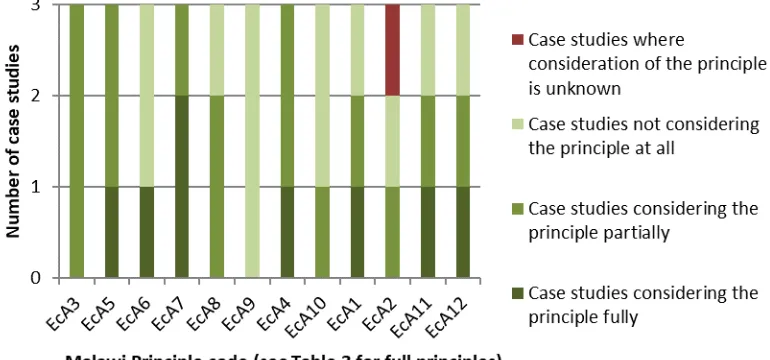
[image:10.595.167.432.343.482.2]3.1.1 Overall consideration of the Malawi Principles 253
Table 4 presents a summary of the evaluation of the three case study land use planning frameworks 254
against the Malawi Principles. The full analysis is presented in Appendix 2. Overall, the evaluation 255
indicates that consideration of the Principles is reasonable although the Principles were considered 256
fully in only 22% of ‘instances’ (12 Malawi Principles and three case studies evaluated equates to 36 257
possible ‘instances’ where the Principles could have been considered). Principles were considered 258
partially in 42% of instances and not at all in 33% (Figure 1). 259
[image:10.595.167.432.557.715.2]260
Figure 1: Degree to which Malawi Principles have been considered – percentage of instances across
261
all three case studies
262
263
Figure 2: Degree to which individual case studies have considered the Malawi Principles
11 At the level of individual case study planning frameworks (Table 4 vertical analysis), EERA considered 265
the Malawi Principles most comprehensively (five principles were considered fully and four partially) 266
and GNOM the least (two Principles were considered fully and four partially). Whilst THESAURUS 267
considered the least number of Principles fully (just one), seven Principles were considered partially. 268
This is indicated on Figure 2. 269
3.1.2 Consideration of individual Malawi Principles 270
At the level of individual Malawi Principles (Table 4 horizontal analysis), several Principles have been 271
considered fairly well by the case studies, namely: EcA3 on effects on adjacent ecosystems; EcA5 on 272
ecosystem structure and function; EcA7 on appropriate spatial and temporal scales; and EcA4 on 273
management of ecosystems in an economic context. These four Principles have been considered 274
either partially or fully by all three case studies. However, several Principles were considered less well: 275
EcA6 on environmental limits; EcA9 on the importance of ecosystem management recognising that 276
change is inevitable; and EcA10 on balancing the use and conservation of biodiversity. These 277
[image:11.595.107.492.322.502.2]Principles have not been considered at all by at least two of the case studies. This is indicated on 278
Figure 3. A further explanation of these findings is provided below. 279
280
Figure 3: Degree to which individual Malawi Principles have been considered – number of instances
281
across all three case studies
282
EcA7 on appropriate spatial and temporal scales has been considered most comprehensively by the 283
three case study planning frameworks (Figure 3). All three are designed to operate at broad spatial 284
scales (the region or sub-region) and planning at this scale means that key natural features are likely 285
to be encompassed (e.g. large ecological networks, water catchments). Ecosystem scale planning in 286
this regard means that the functional values of ecosystems can be meaningfully assessed (e.g. 287
ecological connectivity, catchment wide hydrological cycle function). EERA and GNOM also operate 288
at relatively broad temporal scales. In EERA’s case, temporal scale issues are addressed by assessing 289
pressures and trends on environmental indicators, the objective being to “suggest the likely evolution 290
of the current state of the environment” (LUC, 2008 p.37). For GNOM, the framework is aligned to the 291
statutory development planning process in Scotland, which undertakes planning across ten-year 292
12
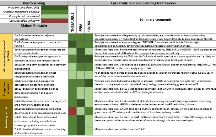
Table 4: Evaluation of case study planning frameworks against the Malawi Principles – summary evaluation matrix
294
Key to scoring
Case study land use planning frameworks
Principle considered fully
THESAUR
US
EE
R
A
G
NO
M
Summary comments
Principle considered partially Principle not considered Consideration unknown
Malawi Principle
M
an
ag
em
en
t
o
f n
at
u
ral
sys
te
m
s
EcA3: Consider effects on adjacent ecosystems
Principle considered to a degree only by all case studies; e.g. consideration of key transboundary ecosystem processes (THESAURUS) and broader scale issues beyond the study area boundaries (EERA). EcA5: Conserve ecosystem structure and
function
Principle considered at least to a degree. THESAURUS considers the Principle fully through a comprehensive ES typology covering all ecosystem processes/intermediate services. EcA6: Ecosystem management must respect
environmental limits
Mixed consideration. Environmental limits not considered by THESAURUS or GNOM. EcA6 type issues are the central premise of EERA where the Principle has been considered fully.
EcA7: Adopt the ecosystems approach at appropriate spatial and temporal scale
Principle considered fully by EERA and GNOM both of which operate at a broad spatial scale (i.e. likely to encompass key natural features) and consideration of planning up to 10-year horizon.
EcA8: Set long-term objectives for ecosystem management
Mixed consideration. Considered to a degree by EERA and GNOM but not considered by THESAURUS. For EERA and GNOM, similar issues apply as per EcA7.
EcA9: Ecosystem management must recognise that change is inevitable
Poor consideration across all case studies; no explicit or implicit references found to EcA9 type issues in any of the material reviewed in the evaluation.
Ecos
ys
te
m
servi
ces
EcA4: Understand and manage the ecosystem in an economic context
Principle considered at least to a degree in all cases. GNOM considers the Principle fully; in particular, there is a strong emphasis on the role of the planning system delivering green network/ES.
EcA10: Ensure an appropriate balance between conservation and use of biodiversity
Mixed consideration. EcA10 is not considered by EERA and GNOM. In particular, EERA places an emphasis on the potential substitutability of ES, including biodiversity.
Invo
lvi
n
g
pe
o
ple
EcA1: Objectives for ecosystem management are a matter of societal choice
Mixed consideration. EERA considers EcA1 fully by focussing on socially based approaches to defining environmental limits. GNOM is designed to be implemented by GIS technicians/planners.
EcA2: Ecosystem management should be decentralised to the lowest appropriate level
Mixed consideration. GNOM considers EcA2 to a degree through its focus on the economic realities of green network/ES delivery and consideration of local level delivery models.
EcA11: Consider all forms of relevant information including scientific/local knowledge, practice and innovation
Mixed consideration. Similarly to EcA1, EERA considers this Principle fully. THESAURUS recognises that there are opportunities to consider wider information though this was not acted upon.
EcA12: Involve all relevant sectors of society and scientific disciplines
Mixed consideration; similar issues to EcA11.
13 EcA3 on effects on adjacent ecosystems has been considered partially by all three case studies. This 296
Principle focusses on the role of ecosystem managers considering the effects of their activities on 297
adjacent ecosystems. All three planning frameworks operate at the regional or sub-regional scale and, 298
whilst none of the areas encompassed are delineated on the basis of ecosystem boundaries (e.g. water 299
catchments, whole landscapes), they are of sufficient scale such that they are likely to encompass 300
several ecosystems or natural features; e.g. multiple water catchments, contiguous areas of habitat 301
network. As such, we suggest that all three cases have the potential to consider effects on adjacent 302
ecosystems although there was no strong evidence within the documentary sources reviewed (Table 303
2) that this is taking place in practice. 304
EcA5 on the conservation of ecosystem structure and function was considered fully by THESAURUS 305
and partially by EERA and GNOM. This Principle focusses on the functional aspects of ecosystems; i.e. 306
the interaction of biotic and abiotic components (natural capital “assets”) giving rise to ES “flows” (UN, 307
2014). THESAURUS includes a comprehensive assessment of ecosystem processes and intermediate 308
services (e.g. hydrological cycle function and ecological networks) through the use of network analysis 309
and spatial representation of ES at the land parcel level (section 3.2.1). EERA and GNOM are less 310
comprehensive in this regard, focussing on one or two aspects of ecosystem function only; e.g. 311
ecological networks (GNOM) or a very abiotic focus only (EERA). 312
EcA4 on management of ecosystems in an economic context was considered fully by GNOM and 313
partially by THESAURUS and EERA. The GNOM case has a distinct focus on the economic drivers for 314
sustainable land use initiatives (enhancement of the green network – see Appendix 1) including the 315
need to “sell the benefits” to developers and decision-makers2 and using spatial datasets on 316
development and regeneration priorities in the analysis to identify areas of change where regulatory 317
drivers (and potentially incentives) can be used to influence sustainable land use outcomes. Overall, 318
GNOM has a strong focus on using the tools available within the statutory planning system (regulation 319
and incentives) as a driver for delivering sustainable land use and enhanced ES. The THESAURUS case 320
recognises how context can influence the value of ES (including monetary value) including costs 321
associated with land management to ensure a desired level of service. 322
Several Principles were considered less well. EcA6 on respecting environmental limits was not 323
considered at all by THESAURUS and GNOM though it was considered fully by EERA (this being the 324
focus of the initiative). Poor consideration of EcA6 is particularly concerning given the importance of 325
environmental limits for the sustainable management of land and other forms of natural capital 326
(Haines-Young et al., 2006) and its prevalence in policy at various levels (HM Government, 2005; EC, 327
2013b; Scottish Government, 2014). EcA9 on ecosystem management recognising that change is 328
inevitable was not considered at all by any of the case studies. This is a critical issue for land use 329
planning where adaptive management Principles should be built into policies and monitoring regimes 330
in recognition of future uncertainty and the need to maintain flexibility. EcA10 on balancing the use 331
and conservation of biodiversity was also considered poorly; it was considered partially by THESAURUS 332
and not at all by EERA and GNOM. THESAURUS addresses biodiversity explicitly though there is no 333
specific mechanism in place for balancing its use and conservation. EERA’s poor consideration of 334
EcA10 is particularly concerning as the approach emphasises transferability: “opportunities to import, 335
recreate or substitute the services [provided by the study area]” (LUC, 2008 p.20). Any such 336
transferability should not be applied to critical natural capital assets (e.g. biodiversity, water, soil) in 337
order to maintain ecosystem resilience and sustain ES flows (Walker et al., 2010). 338
14 3.2 What types of method/approach have the case study land use planning frameworks used to 339
consider and integrate the Malawi Principles in their land use planning? 340
The second evaluation question considered the methods and approaches used by the case studies 341
within their land use planning activities; the rationale being that they can help to integrate the Malawi 342
Principles. We define methods/approaches after Scott et al. (2014 p.19): “specific mechanisms or 343
methods that aid, influence or inform PPPP [policy, plan, programme or project] processes and 344
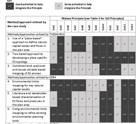
outcomes”. Drawing on the analysis in sections 3.2.1 - 3.2.3 and Appendix 2, Table 5 summarises the 345
methods/approaches identified and their potential to help integrate the Malawi Principles. The 346
assessment in Table 5 provides an initial indication only of the potential linkages/support between the 347
methods in use by the case studies and their potential to help integrate the Principles. It is based on 348
the authors’ knowledge of land use planning processes (especially in the UK) and the results of the 349
case study analysis at section 3.1. However, this is a key area for future research; e.g. undertaking 350
summative evaluations (HM Treasury, 2011) of case study planning frameworks with and without the 351
[image:14.595.52.528.331.760.2]use of certain methods/approaches to try and isolate their effect on specific Principles (section 4.4). 352
Table 5: Land use planning methods/approaches utilised by the case studies and their potential to
353
help integrate Malawi Principles with planning
354
KEY
Good potential to help
integrate the Principle
Some potential to help integrate the Principle 355
Method/approach utilised by the case study
Malawi Principle (see Table 3 for full Principles)
Ec
A
3
Ec
A
5
Ec
A
6
Ec
A
7
Ec
A
8
Ec
A
9
Ec
A
4
Ec
A
10
Ec
A
1
Ec
A
2
Ec
A
11
Ec
A
12
Methods/approaches utilised by THESAURUS 1. Use of a “place-based”
approach to define natural capital assets and flows in the plan area
2. Two-tiered approach to developing a place specific ES typology
3. Combined land use/cover and causal variable based mapping of ES proxies
Methods/approaches utilised by EERA 4. Environmental limits
mapping for key natural capital assets
5. Literature and stakeholder based characterisation of ES flows and pressures in the plan area
6. Using environmental limits mapping to refine existing environmental planning tools
15
Method/approach utilised by the case study
Malawi Principle (see Table 3 for full Principles)
Ec
A
3
Ec
A
5
Ec
A
6
Ec
A
7
Ec
A
8
Ec
A
9
Ec
A
4
Ec
A
10
Ec
A
1
Ec
A
2
Ec
A
11
Ec
A
12
7. GIS based opportunities mapping for sustainable land use
8. Close integration with statutory land use delivery mechanism
356
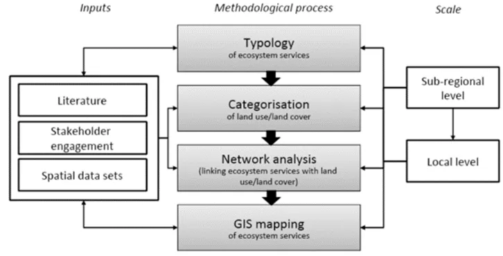
3.2.1 THESAURUS – key methods/approaches 357
The evaluation of THESAURUS identified three key aspects of methodology (Table 5). An overview of 358
THESAURUS’ approach is shown at Figure 4. Firstly, a “place-based” approach was used as an overall 359
framing to define an ES typology for the study area. This approach was proposed in a related Defra 360
research project (Haines-Young and Potschin, 2008) as a means of taking an integrated view of 361
habitats, ES and their interrelationships, within a defined area. It also defines the stakeholders and 362
communities affected by decisions, linking to the involving people Principles. THESAURUS recognised 363
that the approach must be tailored to the specific decision-making context; urban/peri-urban land use 364
planning at the sub-regional scale. In particular, it was important to “express the ecosystem services 365
identified in a language and context familiar to planners” (Sheate et al., 2012 p.8). Accordingly, 366
openspace categories from extant planning policy were used as the unit of analysis for ES assessment; 367
these were familiar to planners and land use/cover data for these categories was available at a suitably 368
granular scale for sub-regional analysis. 369
[image:15.595.114.477.438.623.2]370
Figure 4: THESAURUS – overall methodological approach (Source: Sheate et al., 2012) 371
Secondly, aligned with the overall place-based approach, THESAURUS adopted a two-tiered approach 372
to developing an ES typology for the study area (indicated on the left of Figure 4). A typology in this 373
regard “describes and categorises the ecosystem services provided in [a study] area” (Sheate et al., 374
2012 p.7), recognising that the range and type of services provided will be place specific. The typology 375
development involved two steps: (1) literature review; and (2) stakeholder engagement. The 376
literature review considered wider and locally relevant literature; the former (e.g. national ecosystem 377
16 planning frameworks, community surveys). Stakeholder engagement then further validated the 379
literature defined typology. Both steps support key ecosystems approach Principles, especially EcA11 380
on considering all forms of relevant information. 381
Thirdly, THESAURUS visually represented the ES identified in the typology exercise using a Geographic 382
Information System (GIS) “so that planners could see which areas were likely to provide which services” 383
(Sheate et al., 2012 p.15). Using GIS to map ES in this manner can provide a useful visual depiction of 384
the benefits and potential multifunctionality (where multiple services coincide) of existing land 385
use/cover (Figure 5). THESAURUS mapped proxy ES using a combination of land cover data and causal 386
variables which are the spatial-contextual factors that influence the importance of a given ES, in a 387
given location (Eigenbrod et al., 2010). Incorporating causal variables like this can improve the quality 388
of a basic land cover proxy (ibid); a key innovation within THESAURUS was the identification of causal 389
variables for all ES identified through the typology exercise. 390
3.2.2 EERA – key methods/approaches 391
The evaluation of EERA identified three key aspects of methodology (Table 5). Firstly, EERA has 392
developed a workable methodology for mapping environmental limits for several natural capital 393
assets. This includes: (1) defining indicators; (2) identifying suitable datasets; and (3) determining 394
environmental limits for each asset considered (with stakeholder input). The mapped outputs are 395
1km x 1km cells with a binary “acceptable” or “unacceptable” score in terms of the environmental 396
limit for the asset considered (Figure 6). These maps have clear utility informing spatial planning as 397
per EERA’s objectives; development should be avoided in areas where the status of natural capital 398
assets is unacceptable and/or appropriate restoration or mitigation action should be taken first. 399
400
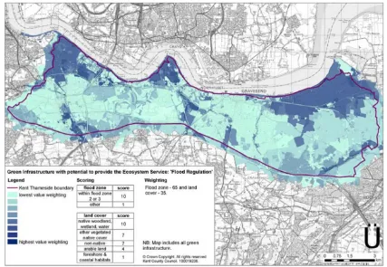
Figure 5: THESAURUS – flood regulation proxy ecosystem service map (Source: CEP and GeoData 401
Institute, 2008a)
[image:16.595.83.510.406.701.2]17 Secondly, EERA developed a literature and stakeholder based characterisation3 of the ES flows 403
provided by various natural capital assets (e.g. water, air, landscapes, biodiversity) and linked these 404
various components of natural capital to drivers and pressures that can affect their extent and 405
condition (e.g. climate change, land take, population growth). Land use related mitigation responses 406
to the pressures are also identified as an input to planning processes and tools (see below). 407
Thirdly, following the natural capital characterisation above, EERA is designed to add value to SEAs of 408
land use plans by helping to determine the significance of environmental effects. Specific links are 409
made between natural capital assets, ES flows and environmental limits and the pressures that can 410
affect these. Where the SEA identifies the potential for spatially explicit environmental effects 411
(pressures), these are linked to environmental limits maps (Figure 6) to help determine effect 412
significance enabling “more spatially specific conclusions to be drawn about where within the plan 413
area environmental mitigation may be required, and for which [assets] and service” (LUC, 2008 p.14). 414
EERA’s alignment with SEA may also support the delivery of involving people related Malawi Principles 415
(Tables 3 and 5) as the process of defining environmental limits in EERA is predicated “[not just on] 416
scientific knowledge but also local perceptions of the relative value of environmental features or 417
benefits” (ibid). In essence, the SEA and environmental limits mapping are mutually supportive; the 418
former provides a public engagement platform for the latter (via statutory consultations) whilst the 419
latter adds robustness to the former. 420
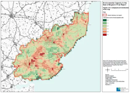
[image:17.595.86.508.346.648.2]421
Figure 6: EERA – composite environmental limits map (Source: LUC, 2008). Note: Figure 6 is an overlay 422
of all individual environmental limits maps produced in EERA. The cumulative score of “unacceptable” cells is 423
calculated in GIS for each cell; the higher the cumulative score (dark red cells), the lower the environmental 424
capacity and vice versa. 425
426
18 3.2.3 GNOM – key methods/approaches
427
The evaluation of GNOM identified two key aspects of methodology (Table 5). Firstly, a GIS based 428
method was developed that identifies spatial opportunities for enhancing green network sites4 and 429
associated ES. The overall objective is to identify spatial priorities for targeting green network 430
investment. This is achieved using spatial datasets and weighted raster overlays to answer spatial 431
queries concerning: (1) the available green network resource; and (2) its functionality in terms of key 432
ES. GNOM’s analysis considers ecological connectivity and recreation/active travel as key functions of 433
the green network. Shortfalls in both of these services are assessed as green network priorities; i.e. 434
spatially defined gaps in provision highlighting demand for additional green network (Figure 7). 435
[image:18.595.147.457.218.629.2]436
Figure 7: GNOM – GIS methodology schematic (Source: GCVSDPA, 2011). Note: Each layer in the raster 437
analysis can be weighted to focus the analysis on different priorities (e.g. ecological networks vs. socio-economic 438
deprivation). The final output is a weighted priority score; the higher the score the greater the priority for green 439
network investment in that cell/area. 440
4 The GNOM delivery partnership defines the green network as: “a strategic programme of greenspace enhancements designed to promote healthier lifestyles, better environments, greater biodiversity, stronger communities and economic prosperity”:
19 The analysis also considers drivers of land use change: (1) existing poor-quality greenspace; (2) sites 441
zoned for development; and (3) areas experiencing high levels of socio-economic deprivation. The 442
intention is that well-designed green network intervention can help to address these issues whilst 443
delivering multiple benefits. As per Figure 7, GNOM’s weighted raster overlays assess all input 444
datasets to determine an overall priority score for each cell. These scores then feed into formal land 445
use planning processes. 446
Secondly, the GNOM approach is designed to be fully integrated with statutory land use planning 447
processes in Scotland; specifically, Local Development Plans (LDP) as per the Planning etc (Scotland) 448
Act (2006). The Scottish planning system is “plan-led” whereby development plans set out how places 449
should change in the future. LDPs set out where most new developments will happen at the local 450
level and policies to guide decision-making on planning applications (Scottish Government, 2015). 451
GNOM outputs are designed to inform the LDP-development process, feeding into the draft plan at 452
an early stage to help set strategic priorities for green network intervention. The statutory planning 453
system is then used as a strong (legal) mechanism for green network delivery; e.g. as a condition of 454
planning consent, developers are required to deliver relevant green network projects within/near 455
their development (e.g. active travel infrastructure, habitat creation, sustainable urban drainage). 456
This aspect of GNOM is particularly relevant to EcA4 on understanding and managing the ecosystem 457
in an economic context; GNOM demonstrates a critical awareness of the need to use economic levers 458
(development) to deliver sustainable land use outcomes. 459
3.3 What are the main strengths, weaknesses, opportunities and threats of the example land use 460
planning frameworks in terms of how they have considered and integrated the Malawi Principles? 461
This section synthesises the results through a SWOT analysis (strengths; weaknesses; opportunities; 462
threats) at Table 6 and considers the implications for practice elsewhere. A main finding from the 463
SWOT is that the cases analysed exhibit more strengths than weaknesses. This reflects their 464
assessment against the Malawi Principles whereby Principles were incorporated at least “partially” in 465
64% of instances (Figure 1). Key strengths relate to: (1) using specific methods and approaches to 466
communicate findings from ecosystem assessments effectively; (2) using stakeholder input to refine 467
and validate technical modelling and assessments; and (3) some good consideration of ecosystem 468
processes (functional values). A key theme within the identified strengths is their relevance to the 469
involving people category of Malawi Principles (Table 3). The main weaknesses identified relate to 470
poor consideration of environmental limits (EcA6) and biodiversity (EcA10). Inadequate consideration 471
of biodiversity in planning may mean that this critical component of natural capital is eroded through 472
poor land use management decisions (e.g. sustained loss of natural and semi-natural habitats). 473
Effective consideration of environmental limits could provide a “backstop” to protect critical natural 474
capital though this is absent in two of the three cases. 475
Related to these strengths and weaknesses, there are also several opportunities and threats that 476
should be considered in the development of land use planning policy and practice (Table 6). This is 477
particularly true for the case studies considered in this research and their broader categories (section 478
2; Table 1; Appendix 1), however, they are also likely to be important considerations for land use 479
planning practice elsewhere. In terms of strengths, firstly, the focus on stakeholder engagement and 480
the involving people Malawi Principles (Table 3) arguably creates an opportunity for further 481
democratisation of land use planning processes. Deliberative engagement with stakeholders and 482
affected communities at key decision-making junctures can improve decision outputs (e.g. plans and 483
policies) and enhance accountability (Bourgoin and Castella, 2011; NAFRI, 2012). Furthermore, formal 484
ex-ante assessment procedures (e.g. SEA) can provide a mechanism for this engagement (Geneletti, 485
20 Brown, 2005; Raymond et al., 2009; Phillips et al., 2016). Secondly, there is an important opportunity 487
to improve consideration of temporal scale in planning (EcA7). Whilst spatial scale was considered 488
effectively in all cases, planning timeframes were generally insufficient to identify and facilitate 489
ecosystem restoration which can take many 10s – 100s of years, requiring a much longer-term 490
approach (Bennett et al., 2015). Finally, as all three cases undertook some form of proxy based 491
ecosystem assessment/mapping there is an opportunity to improve the accuracy of outputs and 492
subsequent decisions by using better indicators and data (Eigenbrod et al., 2010). The most critical 493
threat identified relates closely to poor consideration of biodiversity and environmental limits (a key 494
weakness) and the subsequent risk of land use management continuing to drive the degradation of 495
natural capital assets (Schröter et al., 2005; Foley et al., 2006). This is particularly important in relation 496
to recent assessments of status, trends and pressures on natural capital at global and European levels; 497
e.g. in Europe the continued loss, fragmentation and degradation of natural and semi-natural habitats 498
is being driven by land use management issues related to urban sprawl, agricultural intensification 499
21
Table 6: SWOT analysis of case study land use planning frameworks in terms of their ability to operationalise the ecosystem approach
501
Strengths Weaknesses
Relatively comprehensive consideration of ecosystem processes and intermediate services: EcA5 focusses
on conserving ecosystem function; i.e. maintaining the natural capital assets that underpin ES flows. THESAURUS considered all relevant aspects of ecosystem function through a network analysis approach. EERA and GNOM both considered some aspects though less comprehensively.
Effective consideration of spatial and temporal scale: EcA7 requires the ecosystem approach to be adopted
at appropriate spatial and temporal scales. All three cases considered spatial scale effectively. EERA and GNOM considered temporal scale relatively well.
Disaggregating the natural environment using management units familiar to planners: THESAURUS
disaggregated the natural environment into discrete spatial units for planning and management purposes (green land parcels).
Use of qualitative stakeholder input to validate quantitative modelling: all three cases used aspects of
spatial analysis and ecosystem assessment. The expert-led nature of these methods means that less-technical stakeholders (e.g. local communities) can be excluded from participation. THESAURUS and EERA incorporated an explicit stakeholder engagement stage to validate key aspects of the modelling, supporting EcA1, 11 and 12.
Visual presentation of land use management issues to communicate key messages: all three cases visually
presented spatial data/results to communicate important messages to decision-makers; e.g. THESAURUS used ES maps to demonstrate different values of existing land use.
Using a multi-staged, mixed methods approach to refine proxy based methods for ES assessment: land
cover based proxies can be used in the absence of suitable primary data to map ES however they provide only poor estimates for many services (Eigenbrod et al., 2010). THESAURUS used this type of approach but added several additional inputs to refine the basic proxy maps.
Poor consideration of environmental limits: EcA6 focusses on ecosystem
management respecting environmental limits. Only one case considered environmental limits (EERA). This is an issue given the importance of limits/thresholds for the sustainable management of land and other natural capital assets.
Poor/mixed consideration of biodiversity: EcA10 highlights the importance of
striking an appropriate balance between conservation and use of biodiversity. All three cases considered biodiversity within their planning though none had a mechanism in place to balance use and conservation. This is a key concern for EERA which seems to promote transferability between natural capital assets (including biodiversity).
Limited consideration of regulating services: GNOM has limited consideration
of regulating services (e.g. flood storage) and instead focusses on cultural services and some ecosystem processes. A balanced approach to land use/management is likely to require consideration of all service categories.
Opportunities Threats
Further democratisation of land use planning processes: two of the three case studies incorporated a
stakeholder engagement step to help validate modelling processes. In conjunction with formalised ex-ante assessments such as SEA (Geneletti, 2012), there is an opportunity to further democratise land use planning processes by promoting stakeholder and community engagement at key decision-making junctures (Bourgoin and Castella, 2011; NAFRI, 2012). This would strengthen the delivery of all involving people Principles (Table 3).
Improving the accuracy of proxy based ES maps: all three case studies undertook some form of proxy ES
assessment and mapping. There is an opportunity to improve the accuracy of these maps (and therefore the efficacy of related land use management decisions) by using better indicators and data (Eigenbrod et al., 2010).
Improving consideration of temporal scale: spatial scale was considered adequately in all cases.
Appropriate consideration of temporal scale (EcA7) however requires an extension of planning time horizons (EcA8) such that lengthy ecosystem restoration processes can be considered adequately; the literature suggests that ecosystem restoration timescales can vary from 1-5 years (eutrophic ponds) to 1,000-5,000 years (blanket bogs) (Bennett et al., 2015). There is a key opportunity for land use planning to take a longer-term view (e.g. 15-30 years) to ensure that restoration of natural capital assets (and therefore ES flows) is considered adequately.
Continued degradation of key natural capital assets and flows: generally poor
consideration of biodiversity (EcA10) and environmental limits (EcA6) within the case studies highlights the risk of land use management continuing to drive degradation of key natural capital assets including biodiversity and soils (Schröter et al., 2005; Foley et al., 2006). Effective consideration of environmental limits in planning can provide an important “backstop” to protect critical natural capital assets.
Land use planning may not identify nature based solutions for climate risk
management: much recent attention has been given to the role of nature based solutions helping to mitigate climate change risks (EEA, 2015b). Land use planning has a key role to play by identifying and protecting the habitats and green infrastructure that provide important regulating services (e.g. flood storage, local climate control). Poor consideration of regulating services in planning processes may mean that such opportunities are missed.