Porta, S. and Crucitti, P. and Latora, V. (2008) Multiple centrality assessment in Parma: a network
analysis of paths and open spaces. Urban Design International, 13 (1). pp. 41-50. ISSN 1357-5317
http://
strathprints
.strath.ac.uk/18468/
This is an author produced version of a paper published in Urban Design International, 13 (1).
pp. 41-50. ISSN 1357-5317. This version has been peer-reviewed but does not
include the final publisher proof corrections, published layout or pagination.
Strathprints is designed to allow users to access the research output of the University
of Strathclyde. Copyright © and Moral Rights for the papers on this site are retained
by the individual authors and/or other copyright owners. You may not engage in
further distribution of the material for any profitmaking activities or any commercial
gain. You may freely distribute both the url (
http://
strathprints
.strath.ac.uk
) and the
content of this paper for research or study, educational, or not-for-profit purposes
without prior permission or charge. You may freely distribute the url
(
http://
strathprints
.strath.ac.uk
) of the Strathprints website.
MULTIPLE CENTRALITY ASSESSMENT IN PARMA A NETWORK ANALYSIS OF PATHS AND OPEN SPACES
SERGIO PORTAa, PAOLO CRUCITTIb, VITO LATORAc
a Dipartimento di Progettazione dell’Architettura, Politecnico di Milano, Italy, [email protected] b Scuola Superiore di Catania, Italy, [email protected]
c Dipartimento di Fisica e Astronomia, Università di Catania and INFN Sezione di Catania, Italy, [email protected]
One of the largest of Europe, the recently realized University Campus “Area of the Sciences” in Parma, northern Italy, has been planned for a comprehensive programme of renovation and revitalization with a spe-cial focus on vehicular accessibility and the quality of open spaces. As part of the problem setting, Multiple Centrality Assessment (MCA) – a process of network analysis based on primal graphs, a set of different cen-trality indexes and the metric computation of distances – has been implemented in order to understand why the existent networks of open spaces and pedestrian paths are scarcely experienced by students as well as faculty and staff members and appear so poorly integrated with the life on Campus. MCA has also given a relevant contribution to the comparative evaluation of two proposed scenarios, leading to the identification of one final solution of urban design.
In the present paper the first professional application of MCA, an innovative approach to the network analy-sis of geographic complex systems, is presented and its relevance in the context of a problem of urban design illustrated.
1. Introduction
The science of networks has been witnessing a rapid development in recent years since the seminal work of Watts and Strogatz on the so-called “small worlds” in 1998 [1]: the metaphor of the network has been applied to complex, self-organized systems as diverse as social, bio-logical, technological and economic, leading to several unexpected results [2]. In particular, the issue of centrality
in networks has remained pivotal, since its introduction in a part of the studies of humanities named structural soci-ology [3]. The idea of centrality was first applied to hu-man communication by Bavelas [4, 5] who was interested in the characterization of the communication in small groups of people and assumed a relation between struc-tural centrality and influence/power in group processes. Since then various measures of structural centrality have been proposed over the years to quantify the importance of an individual in a social network. Currently, centrality is a fundamental concept in network analysis though with a different purpose: while in the past the role and identity of central nodes was investigated, now the emphasis is more shifted to the distribution of centrality values
through all nodes: centrality, as such, is treated like a shared resource of the network “community” – like wealth in nations – rather than the unique property of the excel-lent.
In urban planning and design centrality – though under different terms like “accessibility”, “proximity”, “integra-tion”, “connectivity”, “cost”, “effort” – has entered the scene stressing the idea that some places (or streets) are more important than others because they are more central
[6]. A pioneering discussion of centrality in the analysis of spatial systems has been successfully operated after Hillier and Hanson seminal work on cities since the mid Eighties [7]. Space Syntax, the related methodology of urban analysis, has been raising growing evidence of the
correla-tion between the level of “integracorrela-tion” of urban spaces – a closeness centrality in all respects – and phenomena as diverse as crime rates, pedestrian and vehicular flows, re-tail commerce vitality and human wayfinding capacity [8]. However, the Space Syntax approach is profoundly differ-ent from most previous uses of networks in geographic space, i.e. in transportation and land use planning or eco-nomic geography: in fact, while in those studies the urban pattern is subjected to a primal translation in a graph, where streets are turned into edges and intersections into nodes, Space Syntax follows the dual representation where streets are turned into nodes and intersections into edges. This dual character leads Space Syntax to the abandonment of metric distance (one street is one point no matter its real length) – which, conversely, was the core of those territorial studies – and to actually reach the topologic world of non geographic systems. Moreover, the Space Syntax analysis is mainly based on just one central-ity index, called “integration”, which can be used only in association with a generalization model in order to mini-mize the so called “edge-effect”, a typical distortion of the spatial distribution of centrality values that groups higher scores around the centre of the image no matter the actual configuration of the network [9, 10].
2. Primal graph construction and Multiple Centrality Assessment (MCA): a summary
MCA is a structured process aimed at the evaluation of the spatial distribution of centrality over geographic sys-tems like syssys-tems of urban streets or spaces.
The first step in operating MCA is the translation of the spatial system into a graph which is a mathematical entity defined by a set N of nodes and a set K of links, or edges
connecting pairs of nodes. Roughly speaking, a street (or spatial) pattern is translated in a primal graph so that inter-sections (or places) are turned into nodes and streets (or connections) into edges. Networks of streets and intersec-tions are graphed under a “road-centerline-between-nodes” rule: one edge is defined by just two end-nodes (from-node and to-node) and a variable number of ver-texes (points of linear discontinuity); edges follow the geographical footprint of real streets as they appear on the original map; links between two edges are always located at one of the two defining nodes (intersections); the dis-tance between two nodes is calculated metrically along the edge, following real curves and angles. Thus, streets are identified directly on the original map, with no use of any generalization model.
Networks of places and connections are analogous to those of street and intersections. In the present work for Parma, places and connections have been given a conven-tional definition: a place is an open space characterized by: 1. a convex internal shape; and 2. visible borders (building facades, tree lines, hedges, pavement changes, paths, fencings…) on at least three quarters of the perime-ter; and 3. a minor dimension < 70 metres. Two places are connected when: 1. the minor distanced between their borders is < 35 metres; and 2. they are not separated by physical barriers (main trafficked streets, closed fencings, buildings, floods, walls, impassable level gaps…).
On such kind of graphs, MCA investigates how central-ity “flows” through edges over nodes. A key feature of MCA is that centrality is considered a multifold concept; in short, we have many centralities depending on what is our notion of “being central”. Heavily drawing from the mentioned studies in structural sociology, we acknowl-edge four different families of “being central”, each de-scribed by a different centrality index: 1. “being central as being close to others”, closeness centrality (CC); 2. being
central as being between others”, betweenness centrality (BC); 3. “being central as being straight to others”,
straightness centrality (SC); 4. “being central as being
critical for all others as a group”, information centrality (IC). Again, we forward the readers to our previous work
for a formal definition of those indexes.
Finally, in MCA all distances are measured metrically; thus, the distance between nodes i and k is, say, 425.32 metres. This metric/geographic concept of distance is used in MCA for all computations, including the identification of shortest paths, or “geodesics”, between pairs of nodes.
All that deeply differentiates MCA from Space Syntax, which conversely is based on dual graphs, the preliminary use of a generalization model (axial mapping), and just one main centrality index (the “integration” centrality, which is a closeness centrality in all respects). Moreover, like all the dual analysis, Space Syntax is necessarily
an-chored to a topologic concept of distance where the dis-tance between nodes i and k is, say, 3 steps. With all the different meanings that have been assigned to the word “step” in recent literature, as street intersection [14], bi-nary direction change [15], gradual direction change [16], characteristic point [17], street-name change [18], step-distance has to be recognized as a direct, unavoidable out-come of the dual approach.
General advantages of MCA, if compared to dual ap-proaches like Space Syntax, are multifold: 1. it is not based on any generalization model, therefore is more legi-ble, feasible and objective; 2. it is fit to access the huge amount of information resources developed under the road-centreline-between-nodes world standard, including network constructed for traffic engineering and modelling or geo-mapping worldwide; 3. it is more realistic, in that it is grounded on metric rather than on step-distance meas-urements; 4. it gives a set of multifaceted pictures of real-ity, one for each centrality index, rather than just one: that leads to more argumentative, thus less assertive, indica-tions for action. Moreover, from a pure research perspec-tive, MCA makes it possible to analyse geographic net-works under the same roof of well established studies of non-geographic ones such as biologic, technological or social networks.
Let’s see how MCA helped in dealing with the open spaces decay in the University Campus “Area of the Sci-ences” in Parma.
3. MCA: the spatial analysis of the University Campus “Area of the Sciences” in Parma
3.1 A case’s outline
The Campus “Area of the Sciences” of the University of Parma has been developed in the last two decades on 77 ha of land at the outskirt of the city of Parma, over a plain area at the bottom of the first Appennini hills. The site de-velopment follows a general plan conceived with the aim of ensuring the largest possible autonomy to each depart-ment, resulting in an addition of self-containing sites, each served by its own parking and accessibility facilities in a huge but poorly maintained and mainly uncontrolled “green” space. At the geometrical center of the site a huge technologic plant is located, while services for food and rest were decentralized to the southern and western fringe of the area. Sport facilities for football, tennis, rugby, golf and gym have been realized over the years in the north western side of the Campus.
A project was requested to face such problems and sug-gest possible solutions. The project envisions integrated actions for both a new model of access and the revitaliza-tion of open spaces. In the following, we offer a short summary of the former and a more extensive illustration of the latter, that was based on MCA.
3.2 The problem of accessibility: a short summary
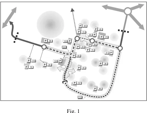
[image:4.595.56.293.281.464.2]The rationale for the betterment of accessibility condi-tions on Campus is the shift from an “everyone-everywhere” model to a selected users in “selected places” one. That can be pursuit at the condition of a deep change in parking habits: a limited increase in parking offer is ob-tained after a large increase of short-time parking and a almost analogous decrease of long-time parking, where the former has been mostly located in central areas, adja-cent to the departments, and the latter in outer areas.
Fig. 1
The conceptual plan of the envisioned development of accessi-bility facilities on Campus: an organic whole substitutes a collec-tion of self-contained, inward-looking settlements while large parts of central areas are freed from in-lot parking, so made available for connecting landscaped environments.
On-street parking largely substitutes parking areas, es-pecially along main streets: on-street parking, in fact, con-tributes to a broader policy of traffic calming on main streets, which have been found dangerous due to the over limits speeds of significant shares of passing vehicles. In so doing, large open areas in central locations that cur-rently work as barriers are turned in new landscaped areas available for high quality connecting facilities like cy-cle/pedestrian paths, rest areas or visual corridors.
In two parts of the main street pattern that have been found critical for the continuity of cycle/pedestrian paths across the whole Campus, the streetscape has been radi-cally converted to pedestrian oriented uses and vehicular uses have been particularly constrained.
Policies for establishing the bicycle as the prime means for internal trips on Campus have been suggested: Univer-sity owned bicycle facilities have been designed along the outer routes of access and long-time parking, anchored to a system of bicycle parking and free-rent that covers the whole area.
The overall effect of accessibility measures is that a col-lection of independent parts are turned into one sole or-ganism and alternative means of transportation, especially for internal trips, are fostered.
3.3 The problem of open space’s livability
The problem of the decay of open spaces on Campus has been investigated posing a special attention to the topological relationships that link each constituent part to every other in the system.
Fig. 2
Consequently, the MCA analysis has firstly constructed three different graphs (fig. 2): 1. the newtork of cy-cle/pedestrian paths; 2. the “potential” newtork of places; 3. the “real” network of places. The difference between the potential and the real networks of places is that in the former all barriers have been artificially cancelled, as if all places were “freely” disposed on a plain and uninterrupted space. The introduction of the potential network is aimed at evaluating, by comparison, the impact of existent barri-ers like buildings or fencings on the connectivity of spaces and their structure of centrality.
Fig. 3
IC distribution over the network of places and connections; 1. the
“potential” network, where physical barriers are not considered; 2. the “real” network, where barriers are considered.
The real network (2) is fragmented in four disconnected sub-networks, each one with its own focal spot; all these “local cen-tres” do not form any organic system.
The potential network (1) is quite different, a single connected network with one emergent centrality located near the cultural centre and the sport facilities.
In all cases, the structure of places and that of paths (see fig. 5, col. 1) are not consistent one the other, in that marginal as a gen-eral rule paths serve central places and central paths serve mar-ginal places.
The real network of places (fig. 31) is a fragmented
sys-tem made of four disconnected networks; each sub-network exhibits an autonomous structure of centrality around four independent “local centers”. All these local centers are located well detached from the distributor
road, while close to the buildings of scientific departments or services.
This structure does not find any correspondence with the structure of centralities on the network of existent paths (fig. 5, col. 1): in this case, paths located along the distributor road are the most central, while internal paths located close to buildings and facilities exhibit a signifi-cant drop in centrality values. The only exception to this pattern emerges with closeness centrality: here, we see that internal paths that are central in the sense that they are more close to all others in the network (CC) are not so
cen-tral in other senses, especially as being the intermediaries among other relationships (CB) or as being critical for the
connectivity of the whole system (IC).
Fig. 4
The proposed new central routes (thick black) for the system of cycle/pedestrian paths: 1. Scenario A: the central spine; 2. Sce-nario B: the ring. After both sceSce-narios were compared through a dedicated MCA analysis (see fig. 4, col. 2 and 3), the former spine-shaped route was selected for the new urban design plan.
The inconsistency between the structures of centrality over the two systems of places and paths seems a major obstacle to the functioning of the open spaces on Campus in terms of social use.
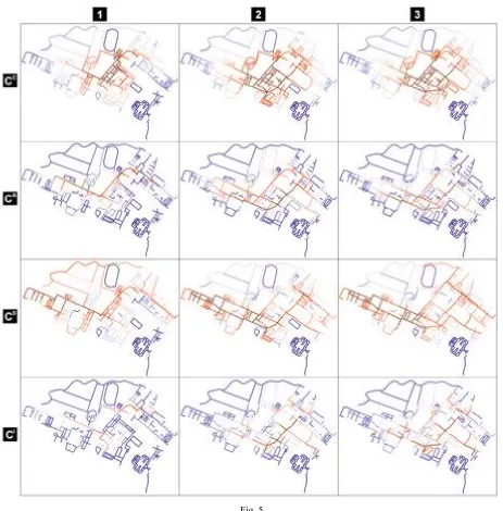
Fig. 5
Centrality distributions over the network of cycle/pedestrian paths and intersections; 1. the existent network; 2. the proposed network, scenario A: the central spine; 3. the proposed network, scenario B: the ring.
The CC distribution appears in all cases deeply affected by the “edge effect”, the distortion that typically groups higher CC scores
around the centre of the image rather than revealing any structural order of the network. In this case, however, the borders of the im-age do express a relevant territorial meaning, because the Campus is really self-centred and isolated at the fringe of the urban settle-ment, a peripheral “island” with just two points of connections with the larger system of the city; so in this specific case the picture emerging from the analysis of CC centrality index represents much more an inherent feature of the real network of the Campus than an
artificial outcome of the borders’ cut.
In the existent network (col. 1), a spine of higher centrality emerges along the distribution road, which is a mostly vehicular channel that presents environmental conditions rather aggressive for pedestrians and cyclists; moreover, almost all buildings on campus are detached from the road, significantly weakening its attractiveness.
The proposed realization of a continuous cycle/pedestrian path (col. 2, scenario A) that runs well beyond the distribution road and links together all activity centres and the most central systems of places on Campus is blessed by a great centrality potential for all in-dexes. Most important, the new path is continuously central, with no significant local drops, weakening the previously dominant cen-trality system of the distribution road. In a way, the new path effectively “drains” cencen-trality flows over the system, while at the same time resulting mostly consistent with the structure of places’ centrality (fig. 3).
The alternative proposal (col. 3, scenario B) does not exhibit a comparable success. The idea of building a ring that includes part of the distribution road lacks an acceptable level of centrality especially in the north-eastern side, with particular reference to BC and IC. The
Thus, the leading aim of the project has been defined to create a new dorsal cycle/pedestrian path that intersects and links all “local centers” running on an internal route. The new dorsal path should be connected to the external vehicular parking-roads in order to favor the car/bicycle exchange.
After a detailed investigation of functions, place central-ities and the conditions of existent paths to be recon-nected, two alternative scenarios were defined and ana-lyzed again through a process of MCA. The two scenarios (fig. 4, thick black) especially differ in the eastern side of the Campus, where the first is spine-shaped and the sec-ond follows a more ring-like route.
The results of the MCA analysis over these two alterna-tive networks are presented in fig. 5, col. 2 and 3.
MCA reveals that the proposed scenario A, the spine-shaped route that crosses the eastern side of the Campus with two other branches departing from the Scientific En-gineering Department towards the sport plants and the Pharmacy Department, scores very well with all centrality indexes. This route, that is obtained by the reconnection of existent but fragmented path segments through new paths, actually achieves a leading role in the whole system, leav-ing lower results to the currently dominant route of along the distribution road.
Most important, the new spine route emerges as a con-tinuous central systems with no significant interruptions. This result is highly significant because in MCA,
differ-ently than in dual generalized analysis like those of Space Syntax, the continuity of a central route is not the outcome of a generalization model and its distinct rationale, but rather the outcome of the “natural flow” of centralities over each edge throughout the real architecture of connec-tions and the metric disposition of spatial components in the system.
A rather worse performance is offered by the ring-shaped scenario B. Centralities describe a fragmented in-terrupted route that do not assume a univocal leading role in the system. The image that emerges, under this sce-nario, is that of a system that shows at least three routes at the same level, none of them really continuous, each with a certain level of contradiction between the four different indexes of centrality.
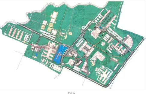
In-depth investigations of local conditions have been implemented by specific MCA analysis as well, but basi-cally the successive steps have been oriented to a classic work of urban design on the basis of the realization of the spine-shaped new cycle-pedestrian route across the Cam-pus. The new path has been detailed with a new lightning system, new paving and a continuous line of blackthorns that gives the path – now called “the blackthorns way” – a distinctive and unique identity, and the quality of open spaces in local centres has been particularly enhanced.
[image:7.595.57.543.247.560.2]Traffic calming techniques have been implemented over all roads, with distinct characteristics between the internal distributor and the external parking road. New landscaped Fig. 6
areas have been designed where large surfaces of existing parking lots have been cancelled. A system of cycle free rental has been provided at interchanges between the car and the pedestrian oriented environments. Architectural solutions have been proposed in some specific spots, i.e. where the “blackthorns way” passes through the main cor-ridor of the Didactic Engineering Department: here, a new atrium has been created that realizes a long invoked new entrance to the building. A core of high quality open spaces has been individuated for the whole Campus adja-cent to the readja-cently built administrative adja-centre, that in-volves landscaped as well as paved areas: a new lake has been designed that is crossed by the “blackthorns way” through a long wooden bridge, and a former rugby facility has been displaced in order to realize a new area for events and celebrations just in front of the lake. A land-scaped park has been finally proposed along the side-branches of the new “blackthorns way”.
4. Conclusions
The Multiple Centrality Assessment (MCA) has proved greatly helpful in orienting a project of urban design across both the problem setting and problem solving phases. In problem setting, MCA provided a new under-standing of the reciprocal relationships between two dif-ferent spatial systems, that of places and that of cy-cle/pedestrian paths; both systems belong to the more general system of the open spaces, so the emerging incon-sistencies have been of full interest for the urban designer. In the Campus “Area of the Sciences” in Parma, the main problem is due to the different structures of the two systems that makes the marginal paths serve the central places and the central paths serve the marginal places. A deep reform of the network of paths has been addressed in the problem solving phase: two alternative solutions have been tested again through a process of MCA. The most convincing of the two scenarios, a spine-shaped new cy-cle/pedestrian route that connects the most central sub-areas and the main centers of activities on Campus, well detached from the distributor road, has been detailed in the project of urban design that touched, on that basis, a wide range of spatial and functional issues.
In the context of this process of urban design, MCA provided a valuable contribution because of its distinctive characteristic of being based on a set of four different cen-trality index, a primal graph representation of complex geographic networks and a metric computation of dis-tances. The result is a multifaceted, argumentative under-standing that does not offer any single, apodictic, univer-sal key to all possible problems of open spaces, but rather an in-depth description of the different properties of the newtork in question, properties that belong to different ways of being central. All these properties, all these dif-ferent ways of being central, do work at the same time in a complex geographic system, with a deep impact on how people and human activities distribute spatially over the system itself. But the “behavior” of those properties and the level of reciprocal consistency depends on local condi-tions, topological as well as geographical.
Finally, we do not think that the network analysis of a complex spatial system, even so multifaceted and sophis-ticated as MCA, can tell the whole story. Complexity can-not be reduced to one dimension, even to such an inclu-sive one like the geo-topological dimension of the spatial newtork. MCA just offers a point of view. An extremely enlightening one, to be true, but just one of the many that contribute to the astonishing, ever changing, surprising world of the social use of public open spaces.
References
[1] Watts D J, Strogatz S H, 1998, “Collective dynamics of small-world networks”, Nature 393 440-442.
[2] Albert R, Barabási A L, 2002, “Statistical Mechanics of Complex networks”, Review of Modern Physics 74 47-97.
[3] Wasserman S, Faust K, 1994, Social Networks analysis (Cambridge University Press, Cambridge, UK).
[4] Bavelas A, 1948, “A mathematical model for group structures”, Hu-man Organization 7 16-30.
[5] Bavelas A, 1950, “Communication patterns in task oriented groups”,
Journal of the Acoustical Society of America 22 271-282.
[6] Wilson GA, 2000, Complex Spatial Systems: The Modelling Founda-tions of Urban and Regional Analysis (Prentice Hall, Upper Saddle River, NJ).
[7] Hillier B, Hanson J, 1984, The social logic of space (Cambridge Uni-versity Press, Cambridge, UK).
[8] Hillier B, 1996, Space is the machine: a configurational theory of architecture (Cambridge University Press, Cambridge, UK). [9] Salheen M, Forsyth L, 2001, “Addressing distance in the Space
Syn-tax syntactical model”, Urban Design International 6 93-106. [10] Ratti C, 2004, “Space Syntax: some inconsistencies”, Environment
and Planning B 31 513-516.
[11] Porta S, Crucitti P, Latora V, 2004, “The network analysis of urban streets: a dual approach”, pre-print cond-mat/ 0411241.
[12] Crucitti P, Latora V, Porta S, 2005, “Centrality measures in urban networks”, in preparation.
[13] Porta S, Crucitti P, Latora V, 2005, “The network analysis of urban streets: a primal approach”, in preparation.
[14] Porta S, Crucitti P, Latora V, 2004, “The network analysis of urban streets: a dual approach”, preprint cond-mat/ 0411241.
[15] Hillier B, 1996, Space is the machine: a configurational theory of architecture (Cambridge University Press, Cambridge, UK). [16] Dalton N, Peponis J, Dalton R, 2003, “To tame a tiger one has to
know its nature: extending weighted angular integration analysis to the description of GIS road-centerline data for large scale urban analysis”, Proceedings 4th International Space Syntax Symposium, London, UK.
[17] Jiang B, Claramunt C, 2002, “Integration of Space Syntax into GIS: new perspectives for urban morphology”, Transactions in GIS 6 151-162.