City, University of London Institutional Repository
Citation
:
Slingsby, A. and Longley, P. A. (2006). A Conceptual Framework for Describing Microscale Pedestrian Access in the Built Environment. Paper presented at the GISRUK06, 5 - 7 Apr 2006, University of Nottingham, Nottingham, UK.This is the unspecified version of the paper.
This version of the publication may differ from the final published
version.
Permanent repository link:
http://openaccess.city.ac.uk/566/Link to published version
:
Copyright and reuse:
City Research Online aims to make research
outputs of City, University of London available to a wider audience.
Copyright and Moral Rights remain with the author(s) and/or copyright
holders. URLs from City Research Online may be freely distributed and
linked to.
A Conceptual Framework for Describing Microscale
Pedestrian Access in the Built Environment
Aidan Slingsby and Paul Longley
Centre for Advanced Spatial Analysis, University College London, 1-19 Torrington Place, London, WC1E 7HB
020 7679 4287 [email protected]
KEYWORDS: built environment, pedestrian access, microscale, conceptual framework, time
1.Introduction
The built environment can be conceptualised as a set of discrete spaces(both inside and outside buildings) within and between which humans move. Human movement can be considered to be constrained by factors such as the characteristics and identity of the pedestrian, the situation (e.g. an emergency or deliberately seeking unauthorised access), potential impediments to movement (e.g. steps and ramps, low or narrow doorways) and the time of day (or the time within any other temporal cycle).
The built environment is host to many pedestrians who move through and between buildings. Although the movement of pedestrians at the microscale level is an important part of the functioning of a city, no conceptual model exists which seamlessly describes microscale pedestrian accessibility both inside and outside buildings over city-wide areas, capturing the rich diversity and complexity of pedestrian movement constraints.
We describe a conceptual framework for describing microscale pedestrian access over city-wide areas. This framework accommodates the multifaceted nature of access constraints and is applicable within, outside and between buildings. The embedding of microscale pedestrian access in city-wide geometrical models establishes the important link between the physical fabric of a city and the connectivity of spaces within which human activity takes place. It opens up a range of GIS applications including the seamless modelling of pedestrians over large areas inside and outside buildings, evacuation planning, crowd control and some less quantitative studies such as the distribution of ‘public’ versus ‘private’ space (e.g. Hwang and Koile, 2005). We will illustrate the conceptual model using output from our prototype.
2.Describing access using graphs
A graph is a set of optionally attributed nodes (points) connected by optionally attributed links
(lines) where links represent relationships between nodes (Tinkler, 1977). Steadman (1983, ch11) illustrates the use of access graphs (where links correspond to access relationships). He compares the connectivity and depth of access graphs in different types of buildings and relates this to building function. The geometry of such graphs only shows connectivity and does not necessarily correspond to the real-world Euclidean geometry; their geometrical form is guided by the need for visual clarity.
models of the urban environment these are likely to be embedded in a 2D Euclidean space; however they may equally be embedded in 3D space. Lee (2004) uses a 3D geometrical network for describing pedestrian access within buildings (on different storeys). Ordnance Survey®1 uses a 2D geometrical network of transport routes (currently only roads) for describing vehicular access in its ‘Integrated Transport Network™2 (ITN) Layer’ product. Links (roads) and nodes (junctions) of ITN have “road routing information” attributes, which include one-way restrictions, turn restrictions and their applicability at different times of day for different classes of user (Ordnance Survey, 2005).
There are plans to introduce a version of ITN for pedestrians. However, a geometrical network is an inappropriate method of describing pedestrian access because the movement of pedestrians is vastly less constrained than that of traffic. Okunuki et al (1999) try to address this problem by
1 ‘Ordnance Survey®’ is a registered trademark of Ordnance Survey, the national mapping agency of Great
Britain.
2 ‘Integrated Transport Network™’ is a trademark of Ordnance Survey, the national mapping agency of
Great Britain.
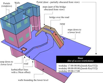
bridge over the road
ramp Portals
(windows)
Walls Portal (door - partially obscured from view)
steps down to a lower level
ramp down to
a lower level road kerbs(offset lines with a 30cm offset)
walls bounding the lower level
steps (part of the bridge obscured from view)
Door
(list of access restrictions)
[image:3.612.110.513.79.406.2]weekday 17:00-00:00,([needs Key532]) weekday 00:00-09:00,([needs Key532]) weekday 09:00-17:00
creating a highly connected networked web for areas of open space. Lee (2004) uses a Straight-Medial Axis Transformation to generate network links based on polygons representing rooms and corridors. These are automatically joined to form a fully-connected 3D geometrical network for a building.
Traditional models of access in which the primary representation is a geometrical network with constraints at nodes and on links tend to be context-specific. We propose a model which captures a richer set of constraints and different contexts of access. Our model represents access within a geometrical model of the built environment conceptualised as a set of topologically-connected discrete spaces. Between these discrete spaces are conceptualisations of ‘walls’ and ‘doors’. We attach time- and pedestrian-dependent access constraints and permissions to the conceptualisations of ‘spaces’, ‘walls’ and ‘doors’. From all this, it is possible to automatically generate a range of customised and context-specific pedestrian access networks. It is anticipated that the same concepts could also be used for vehicular access.
3.Geometrical model of the built-environment
Our pedestrian model needs to be embedded in a geometrical and topological description of the built environment. The mechanism of the access model requires all 3D spaces to be topologically-connected (by pedestrian access) and conceptualisations of any object which acts as a barrier or facilitator of pedestrian access (steps, ramps, walls and doors) to be embedded. We use the model described in Slingsby et al (2005); however any model which provides the characteristics required could be used.
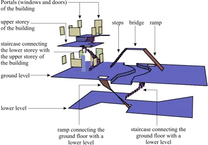
lower level
ramp connecting the ground floor with a
lower level
staircase connecting the ground floor with a
lower level staircase connecting
the lower storey with the upper storey of the building
ground level
steps bridge ramp Portals (windows and doors)
of the building
[image:4.612.96.502.84.367.2]upper storey of the building
Figures 1 and 2 show an example of a small area of built-environment. This is used for the worked example later on.
4.Pedestrian accessibility model
4.1.The algorithm
The access model relies on the following concepts:
• Topologically-connected spaces (by access), each with a position and extent in 3D.
• Conceptualisations of doors, walls or spaces which may act as barriers or facilitators of access, to which attributes can be attached
• Steps and ramps (which tend to impede access)
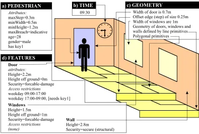
The space accessible by a particular pedestrian, at a particular time from a particular position in space is partly dependent on the geometry of the environment (including the presence and height of steps and the gradient and aspect of ramps) and the geometry and attribution of barriers/facilitators of pedestrian access (walls and doors). The particular pedestrian to gain access has its own attributes, which correspond to a particular person in a particular context (a pedestrian behaves differently in different contexts; e.g. non-emergency and emergency situations). Barriers and facilitators of pedestrian access are ‘walls’ and ‘portals’ (doors and windows) and ‘spaces’ in general. ‘Walls’ and ‘portals’ have geometrical information (width and
b) TIME 09:30 a) PEDESTRIAN d) FEATURES Attributes: maxStep=0.3m minWidth=0.5m minHeight=1.2m maxBreach=indicative age=28 gender=male has key1 Door attributes: Access restrictions Height=2.2m Height off ground=0m Security=forcable-damage weekday 09:00-17:00
weekday 17:00-09:00, [needs key1]
c) GEOMETRY
Width of door is 0.7m
Polygonal primitives
Offset edge (step) of size 0.25m Width of windows are 1m Geometry of doors, windows and walls defined by line primitives
Windows
[image:5.612.107.502.81.346.2]Height=1.5m Height off ground=1m Security=forcable-damage Access restrictions (none) Wall Height=2.8m Security=secure (structural)
height). Some existing ‘spaces’ and ‘portals’ also have a list of pedestrian- and time-dependent access permissions which are evaluated in the context of the current time.
The access model’s algorithm uses a piecemeal approach. From a starting point, it identifies the starting discrete space. It then identifies the topologically-connected (adjacent) spaces. If a ‘wall’ or ‘portal’ lies between the spaces, an evaluation of whether access to the particular pedestrian at the particular time is allowed takes place, according to prevailing access permissions and geometrical constraints. A similar evaluation takes place for ‘spaces’ themselves and the steps and ramps encountered. If access is allowed, the space under consideration is added to the result set of accessible spaces. From these customised sets of accessible spaces, access routes can be generated, perhaps using something similar to Lee’s (2004) Straight-Medial Axis Transformation based method.
4.2.Four factors affecting pedestrian accessibility
There are four factors which are taken into consideration when evaluating access at each iteration. These will be described and explained. Note however that the attributes and rules described are not universal; they are, in part, dependent on the application domain.
4.2.1.The pedestrian
“maxStep” and “maxGradient” indicate the maximum step-height and maximum gradient the pedestrian can negotiate. For a wheelchair-bound individual, “maxStep” might be set to zero and “maxGradient” to 5º; the Department of Transport (2005) has some guidelines. For the majority of pedestrians, this might be set to 0.5m. For a very determined and agile pedestrian (e.g. in an emergency or a burglar), this might be set to in excess of 1m.
“minWidth” and “minHeight” indicates the minimum width and headroom through which the pedestrian is able to pass. This may be affected by bulky equipment being carried by the pedestrian.
“maxBreach” indicates the strength of barrier which the pedestrian is able or willing to breach. For example, the majority of pedestrians would think nothing of ducking under queuing tape, but are less likely to break down locked door in an everyday context. Members of the emergency services may routinely force locked doors, as might burglars.
Pedestrians can be provided with one or more keys (ID, access card or door key), which may provide access to one or more doors (which themselves may be subject to time-dependent access permissions).
Pedestrians can also have properties such as age and gender.
4.2.2.Time
The time at which the access of a particular pedestrian is being delineated is used to evaluate the access permissions held by portals and some spaces.
4.2.3.Geometry
4.2.4.Attributes and access permissions on portals and spaces
‘Portals’ and certain ‘spaces’ have lists of time-stamped access permissions. Access is only allowed if at least one access permission is fulfilled. Each access permission comprises two parts: the time range for which it applies (the time-dependent component) and an optional restriction (the dependent component). Thus different time ranges can have different pedestrian-dependent permissions.
An example of a cyclic time range is:
weekday, 09:00-17:00
Cyclic time-ranges at difference temporal resolutions can also be described.
An example of a restriction for a particular time range is:
([age > 18] and ([needs key4356] or [needs key3457]))
As can be seen, the restriction is in the form of a structured logical expression, with individual expressions enclosed in square brackets combined with “and” and “or” and nested using brackets. Individual expressions can be: “[needs key_id]” (the pedestrian needs a particular key to gain access during the time-range); and otherwise a Boolean expression composed of a pedestrian
exterior walls of building lower level as
seen through the building with an absent interior
building interior is absent
wall of the lower level
bridge steps to the lower level
ramp connecting the ground level with the lower level
[image:7.612.93.521.91.327.2]pedestrian does not have access to the main door of the building
Figure 4: The space accessible by a pedestrian without a key from outside the building, out of office hours (according to the access rules shown in Figure 1). Since access to the main door is not allowed, the interior of the building is absent as is the upper storey, because no access can
attribute, a “=”, “<”, “<=”,”>” or “>=” and then a value (see the “age” example for the pedestrian above).
5.A worked example
We present a simple worked example from the scenario shown in Figures 1 and 2 with annotated output from our prototype. The scenario incorporates a section of road crossed by a bridge, a lower level accessed by a staircase and a ramp from either side of the road and a two storey building whose storeys are connected by a staircase. The main door of the building has the following list of pedestrian- and time-dependent restrictions (shown in Figure 1):
weekday 17:00-0:00, ([needs Key 532]) weekday 0:00-09:00, ([needs Key 532]) weekday 09:00-17:00
ramp to lower level
lower level
wall
kerb
space through which the (absent) ascending staircase would be building main door
[image:8.612.117.489.82.421.2]pedestrian cannot negotiate steps of any height
Figure 5: This shows the space accessible to a pedestrian who starts just outside the building and cannot negotiate steps of any size. Note that all steps are absent; the road, the other side of the
5.1.Time-dependent access
During opening hours, the pedestrian does not require the key to gain access to the building, thus the two pedestrians:
maxStep = 50.0
maxStep = 50.0, has Key532
…are both able to access the entirety of the space (Figure 1) during opening hours (09:00-17:00) in this scenario.
Outside of opening hours, the first pedestrian described above (without a key) is only able to access the space shown in Figure 4, because of the access permissions imposed on the main door of the building. It is for this reason that the interior of the building is absent in Figure 4; the space is not accessible in this context.
5.2.Geometry-dependent access
A pedestrian is only able to negotiate steps with a height of less than the pedestrian’s “maxStep” attribute and ramps with a gradient of less than the “maxGradient” attribute. Spaces beyond steps
hole for access to descending staircase bridge
ramp
[image:9.612.162.428.87.335.2]pedestrian cannot negotiate steps of any height
Figure 6: This Figure shows the space accessible to a pedestrian who starts on the opposite side of the road to that in Figure 5 and cannot negotiate steps of any size. Note that most of the bridge is accessible from this side of the road because this side is a ramp, but there is no access over the bridge. Also note that there is no lower level because access to this from this side of the road is by
and ramps which cannot be negotiated by the pedestrian (e.g. too steep) are inaccessible to the pedestrian (unless accessible by other means).
Figure 5 shows the space accessible by:
maxStep = 0.0, has Key532
…where the pedestrian starts from just outside the building. All elements the shown are accessible by the pedestrian from its starting point; thus this is the area accessible by a wheelchair user. The road and the ground surface on the other side of the road are not accessible because of the kerb step. The bridge and the upper storey of the building are not accessible because they can only be accessed from the pedestrian’s starting point via steps. The lower level is accessible because of its connection to the outside the building by a ramp (albeit a perilously steep ramp). The lower storey of the building is accessible because no steps are required for access and the pedestrian has the required key to gain access out of office hours.
The same pedestrian starting from the other side of the road is able to access the area shown in Figure 6. Note that two pedestrians unable to negotiate kerbs and steps starting from opposite sides of a kerbed road have vastly different and non-overlapping assessable areas. The accessible areas from either side of the road are very different from each other.
6.Conclusion
Although microscale access inside, outside and between buildings is an important aspect of the built environment, no conceptual models exist for its seamless description. We propose a conceptual model of pedestrian- and time-dependent access which can be embedded in geometrical and semantic models of the built environment. This enriched model of the built environment can be the basis for applications such as route-finding, pedestrian modelling, evacuation and crowd control models and the study of the access characteristics of cities.
There is ample scope to extend the capability of the model. For example, the maximum gradient should also take into account the distance over which the gradient exists (Department for Transport, 2005). Also, the possibility of falling down steps, jumping down drops and freewheeling down ramps should also be taken into account
7.Acknowledgements
The authors acknowledge the generous support of the Economic and Social Research Council and Ordnance Survey for funding this work.
References
Department of Transport, (2005), Inclusive mobility, Department of Transport, UK Government.
http://www.dft.gov.uk/stellent/groups/dft_mobility/documents/pdf/dft_mobility_pdf _503282.pdf
Lee, J., (2004), A Spatial Access-Oriented Implementation of a 3-D GIS Topological Data Model for Urban Entities. Geoinformatica, 8, 237-264.
Liu, S. and Zhu, X., (2004), Accessibility Analyst: an integrated GIS tool for accessibility analysis in urban transportation planning. Environment and Planning B, 31, 105-124.
Steadman, J. P., (1983), Architectural Morphology, Pion Limited, London.
Okunuki, K., Church, R. and Marston, J. R., (1999), A Study on a System for Guiding of the Optimal Route with a Hybrid Network and Grid Data Structure. In Papers and Proceedings of the Geographic Information Systems Association, Vol. 8, Japan, pp. 135-138. [English translation available from http://www.geog.ucsb.edu/~marstonj/Guidance_system.htm]
Ordnance Survey, (2005), Integrated Transport Network FAQs. http://www.ordnancesurvey. co.uk/oswebsite/products/osmastermap/itn/faq.html.
Slingsby, A.D., Longley, P.A., Parker, C., (2005). A New Framework for Feature-Based Digital Mapping in Three-Dimensional Space. In Lovett, A. (ed) Innovations in GIS 12, CRC Press, [in press].
Tinkler, K. J., (1977), An introduction to graph theoretical methods in geography. Concepts and Techniques in Modern Geography (CATMOG), 14. GeoAbstracts, University of East Anglia, Norwich, UK
Biography