GEOGRAPHY AND PLANNING IN PALMERSTON NORTH
A Thesis Presented in Partial Fulfilment of the Requirements for the Degree of Master of Arts in Geography
at Massey University
By
VERNON RICHARD CROSS WARREN
- i i
-PREFACE
The statement that "planning has an inescapable geographical basis11
1
is in some respects a truism since town and country planning by i t s nature must operate within a territorial context. I t follows that geography andplanning should stand in some direct relationship to each other but the question of degree of relationship is open to debate. This present work is an attempt to explore and test the contribution which geographical studies of an area can make to one stage of the planning process - the
compilation and analysis of planning data.
Town planning in New Zealand has reached an interesting and critical stage of development. Although comprehensive planning legislation has been in effect since
1
926
i t is only since the passing of the19
53
Town andCountry Planning Act that widespread efforts have been made to prepare planning schemes. During this period as problems have been encountered and experience in the preparation and administration of schemes have been accumulated, critical attention has been focused on the efficacy of both the legislation and the resultant schemes. As a result of this scrutiny substantial amendments were made to the legislation in early
196
7
.
But almost all the emphasis has been placed on procedural matters and points of law; l i t t l e attention
- i i i
has been centred on the content orcpality of the planning schemes themselves. Already development in the main urban centres is controlled by planning schemes and the stage has been reached where a number of planning authorities are placing a considerable degree of reliance on their schemes. It seems therefore, to be appropriate and
important that some assessment of their content and quality should be made.
The nature of planning is such that an assessment of quality and content could be made from a variety of
disciplinary standpoints including economics, sociology and architecture. This study is approached from the geographical point of view and to provide a i efinitive framework for the study the hypothesis is advanced
that:-(a) the planning process in New Zealand should contain a strong geographical component and hence that,
(b) geographically conceived studies of planning districts would provide a sounder basis for planning than the present planning surveys as required and detailed by the legislation.
I t was initially proposed to test the hypothesis by means of a broadly based geographical study of
iv
It soon became apparent, however, that a more satisfactory result would be derived f~om detailed studies of selected aspects of Palmerston North than from a more general survey of the whole city system. Not only would the work have greater depth but i t would also enable a more penetrating analysis of part of the planning process. In addition an analysis of the theoretical relationship between geography and planning together with a bt ~ef discussion of planning in New Zealand would be needed to give relevance and
perspective to the detailed studies of Palmerston North. The work has, therefore, been organised in two main sections - the theoretical background to the hypo-thesis and the detailed test studies.
In the first section a discussion of the
theoretical relationship between planning and geography is followed by a btref examination of planning in New
Zealand with specific reference to legislative requirements and some apparent weaknesses in the planning process.
Finally in this section after reviewing some
aspects of planning in Palmerston North a conceptual basis for an integrated planning survey is advanced. The
requirements of the legislation and the local authority setting for planning have been adopted as decisive factors in the formulation of the survey framework and the
V
If the initial hypothesis is held to be true and i f the work is to have any practical significance then the planning survey proposals should be within the scope of the territorial local authorities who are required to prepare planning schemes.
In the second section two major aspects of the proposed survey - population and manufacturing industry - are analysed in detail together with the detailed study of a problem area. No attempt has been made to exhaust the research possibilities in any of the three test studies. They have been organised within theoverall survey framework and are designed to provide and analyse geographical data which is likely to be significant in the preparation of planning proposals.
The choice of population as one of the test studies rests on the fact that population analysis is fundamental to the remainder of the survey. Population characteristics and trends are dynamic factors which underlie the growth and internal structuring of urban areas. Not only are planning proposals prepared to meet the needs of a predicted future population but the
planner.
vi
Manufacturing poses unique problems for the Industrial space requirements tend to alter over time and are sensitive to a series of variables ranging from changes in industrial structure to
technological innovations. Land allocated for industrial development, usually in association with major transport facilities, tends to be surrounded by other development. I t is important, therefore, that adequate land be set aside for industrial development in industrially suitable locations and in advance of other development.
The problem area selected for study is an area adjacent to old railway yards near the centre of Palmerston North. Now vested in the City these yards are scheduled to be redeveloped for "civic purposes". Parts of the area display signs of deterioration and obsolescence. Although suggestions have been advanced for the redevelopment
of the old yards l i t t l e account has yet been taken of the surrounding area. The test study examines the characteristics and development trends of the area to determine whether these have any relevance to, or implications for the redevelopment of the railway yards.
Palmerston North is in many ways an ideal city for research of this nature. Located on the right bank of
the Manawatu River at the inland fringe of the Manawatu Plain,the city is compact, has a relatively simple
morphology and is administered by one territorial local authority.
- vii
Established in 1867 the city has experienced almost all the fluctuations in growth to which New Zealand towns have been subject and is thus representative of urban growth in this country. Of particular importance the City has a good record in planning administration. The municipality employed planning staff prior to the 1953 Town and Country Planning Act and has had an operative
planning scheme since 1959. A satisfactory basis exists, therefore, in Palmerston North for the testing of the hypothesis.
Finally, i t should be pointed out that the value judgements which preceded the formulation of the hypothesis to be tested here were based on many years of experience in the planning profession particularly in Palmerston North as well as geographic training received at Massey University.
V ;R ;C. WARREN
ACKNOWLEDGEMENTS
Grateful acknowledgement is made of the many people and organisations who made valuable contributions to this research project. Special mention is made
of:-The Department of Labour and the Census Bureau, (particularly Mr. Muschamps, Head of the Bureau) which made essential data available:
The Palmerston North City Council which gave ready access to helpful records, assisted with the duplication and mailing of industrial questionnaires and supplied negatives of District Planning Maps from which Figures 45, 45a, and 45b were reproduced:
The Manawatu Manufacturers1 Association which commended the industrial survey to its members and the many industrialists who gave time to answer the
questionnaire:
The second year geography class af
1
967
at Massey University who assisted with the application ofquestionnaires to the larger companies:
Professor K.W. Thomson and Mr. B.G.R. Saunders of the Geography Department, Massey University for
encouragement, criticism and supervision of the work: Mr. J. Missen and
Mr.
P. Worden of the technical section Geography Department, Monash Univelsity for excellent photocopying of maps and reproduction of photographs:My wife Joy, for typing the final manuscript and her constant encouragement.
---oOo---PREFACE
ACKNOWLEDGMENTS
CONTENTS
TABLES
CONTENTS
MAPS: DIAGRAMS AND PHOTOGRAPHS
PART ONE - THEORETICAL BACKGROUND
Chapter One
-Chapter Two
-Geography and Planning - The Theoretical Relationship.
Planning in New Zealand,
1
13
The administrative setting.
13
The legislative setting.
14
Some Planning Deficiencies in New
1
9
Summary. Zealand.
27
~ Chapter Three - A Geographical Approach to a Planning
Survey for Palmerston North.
30
Planning Objectives and the Planning
30
Survey.
Planning in Palmerston North.
34
Basis for a balanced planning surveyin Palmerston North.
3
7
PART TWO - TEST STUDIES
Chapter Four - Test Study No.
1 -
Population.43
Population Growth in Palmerston North
since
1945.
43
General Characteristics of Population
Growth.
46
Forecast of Population.
6
2
Distributional Characteristics of
Population in Palmerston North.
6
8
Chapter Five
Chapter Six
Test Study No.
2
-
Manufacturing Industry.Manufacturing in New Zealand.
98
The structure of manufacturingindustry in Palmerston North.
101
Employment Trends.
110
Industrial Location in
Palmerston North.
11
6
Industrial Location within
Palmerston North.
1
2
0
Future Industrial Employment.1
24
Space Requirements.1
2
5
The Location and Planning ofIndustrial Land.
134
Implications for Planning.
13
6
Test Study No.3 -
Railway Redevelopment and the Surrounding Area.140
General Relati onship of Railway
Land to the Central Area.
143
Land Use.
14
5
Amenity.
1
55
Population Patterns and Trends.
174
Future Development.180
PART THREE - CONCLUSION
186
APPENDIX A APPENDIX B APPENDIX C APPENDIX D
APPENDIX E APPENDIX F
BIBLIOGRAPHY
Population Data.
The Industrial Survey.
Railway Land Study - Sample Survey. Planning Data Requirements - Extracts ftom Legislation.
Notes on Cartography.
201
20
7
22
1
22
3
229
Palmerston North District Planning MapsTable
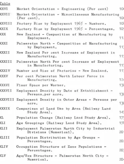
I
TABLES
North Island Urban Areas - Average annual
percentage of population growth.
44
II Palmerston North urban area population growth -natural and migration.
III Net in-migration - Palmerston North City.
47
49
IV Percentages for Age Groups - New Zealand Population52
V Percentages for Age Groups - Palmerston North City
53
VI VII VIII IX X XI XII XIII XIV
xv
XVI XVIIAge/Sex Structure - Palmerston North City
(Percentages).
54
Percentage Employment by Industrial Divisions
-Palmerston North City.
56
Percentage Employment by Industrial Divisions
for Palmerston North, Hamilton & New Zealand.
60
Population - Maoris.
61
Population Growth (percentages) - Maoris.
61
Population Growth - Manawatu Region.
64
Population Estimates - Palmerston North Urban Area
66
Population Growth - Palmerston North Urban Area
67
Population Growth - Palmerston North City.
67
Net Residential Densities - Palmerston North
1966
69
Population Distribution - Palmerston North
-Rates of Growth.
74
Houses and Households by Zones.
81
XVIII Population Distribution - Age Bias of Zone Populations (standard scores).
XIX Population Distribution - Occupational Bias of
Zone Populations (standard scores).
86
XX Percent New Zealand Labour Force in Manufacturing
Industry.
99
XXI Percent New Zealand Labour Force in Manufacturing Industry (excluding Farming).
XXII Market Orientation
1967.
XXIII
Market Orientation Food and Drink (Per cent)XXIV
Market Orientation - Clothing Textiles&
Leather100
103
105
(Per cent)
105
XXV Market Orientation ings (Per cent)
TABLES (continued)
Table
XXVI
XXVII'
Market Orientation - Engineering (Per cent)
10
6
Market Orientation - Miscellaneous Manufacturing
(Per cent).
10
6
XXVIII
Factory Size by Employment1
965
-
Numbers.10
8
XXIX Factory Size by Employment1
9
6
5
-
Percentages.10
9
XXX New Zealand - Composition of Manufacturing by
Employment.
11
2
XXXI Palmerston North - Composition of Manufacturing
by Employment.
113
XXXII New Zealand Per cent Increase of Employment in
Manufacturing.
11
5
XXXIII Palmerston North Per cent Increase of Employment
XXXIV
XXXV
in Manufacturing.
11
5
Number and Size of Factories - New Zealand.
Per cent Palmerston North Labour Force in
11
7
Manufacturing.
1
24
XXXVI Floor Space per Worker.
1
3
0
XXXVII Employment Density by Date of Establishment
-Persons.per acre.
130
XXXVIII Employment Density in Outer Areas - Persons per
XXXIX XL XLI XLII XLIII XLIV XLV acre.
Comparison of Land Use by Area (Railway Land Study Area).
Population Change (Railway Land Study Area).
Age Groupings (Railway Land Study Area).
Employment Palmerston North City by Industrial Divisions (Numerical).
Population Distribution by Age Groups -Percentages.
Occupation Structure of Zone Populations -Percentages.
Age/Sex Structure - Palmerston North City -Numerical.
130
1
47
1
75
17
8
2
01
2
0
2
2
03
[image:13.559.105.526.81.634.2]TABLES (continued)
Table Page
XLVI Births and Deaths - Palmerston North Urban Area
2
0
5
XLVII Deaths by Age Groups - Palmerston North Urban
Area.
2
0
6
XLVIII Industrial Questionnair e Response.
2
0
9
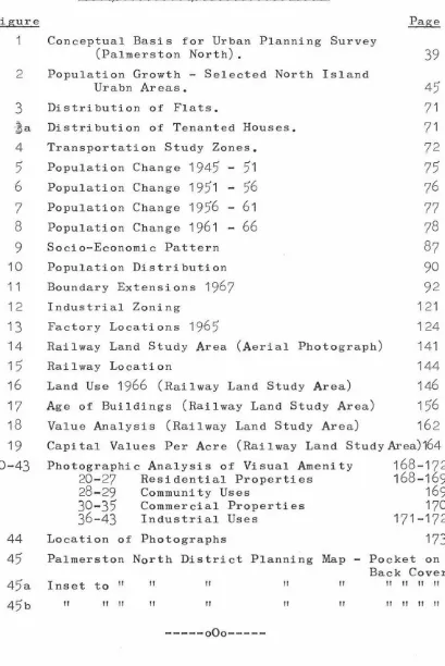
----oOo----MAPS, DIAGRAMS, AND PHOTOGRAPHS.
Figure
1 Conceptual Basis for Urban Planning Survey
(Palmerston North). 39
2 Population Growth - Selected North Island
Urabn Areas. 45
3 Distribution of Flats. 71
l a Distribution of Tenanted Houses. 71
4 Transportation Study Zones. 72
5 Population Change 1945 - 51 75
6 Population Change 1951 - 56 76
7 Population Change 1956 - 61 77
8 Population Change 1961 - 66 78
9 Socio-Economic Pattern 87
10 Population Distribution 90
11 Boundary Extensions 1967 92
12 13 14 15 16 17 18 19
20-43
44
45
Industrial Zoning
Factory Locations 1965
121
124
Railway Land Study Area (Aerial Photograph) 141
Railway Location 144
Land Use 1966 (Railway Land Study Area) 146
Age of Buildings (Railway Land Study Area) 156
Value Analysis (Railway Land Study Area) 162
Capital Values Per Acre (Rai 1 way Land Study Area)164
Photographic Analysis of Visual Amenity 20-27 Residential Properties
28-29 Community Uses
30-35 Commercial Properties 36-43 Industrial Uses
Location of Photographs
168-172
168-169
169
170
171-172
173
Palmerston North District Planning Map - Pocket on Back Cover. Inset to 11 II II II II II II II II
II II II II II II II II II II 11
---oOo---1 •
CHAPTER ONE
GEOGRAPHY AND PLANNING - THE THEORETICAL RELATIONSHIP
With the increasing acceptance and application
of town and country planning throughout the world in
recent decades, the importance of planning in geographical
studies as a prime factor in evironmental change has
intensified. During the same period the contribution by
geographers and by geography to planning particularly in
the field of en~wronmental analysis has also been important.
Despite a mutual interest in human environments, however,
and an increasing overlap of literature, l i t t l e has been
published concerning the relationship between geography
and planning. Those statements which have been made have
tended towards oversimplification i f not mutual exclusion.
Lord Justice Scott is credited with the remark
that "town planning is the art of which geography is the
science" 1 - a statement which is only true in the narrow
sense that planning is a professional 1art1 directed at
the purposeful control and development of human environments
while geography focuses on the scientific study of human
environments, including i t s development whether planned or
otherwise. In this narrow sense planning may well be
defined as applied geography but in the wider sense i t has
also developed its own distinctive scientific base as well
as being closely related in practice to economics,
engineer-ing, architecture, law and politics.
2.
At the other end of the scale Allen has
advanced the view that "geography, at least in Britain, is sadly lacking in the analytical tools to provide and test the descriptive and prescriptive theories which must, for all the imperfections of theory, provide the basis of purposeful human action," 2 and again that "Geography and Planning
3
has many useful things to say, but amply illu-strates the limitations for town and country planning which appear to be inherent in the basic discipline ofgeog-4 raphy. 11
Examined more closely the theoretical inter-disciplinary relationship can be seen to exist at four major levels.
5
2.
3.
4.
5.
(a) Geography and planning are related in the identification of their disciplinary cores and have similar relationships with other disciplines.
(b) The two share much of the same factual material;;;
(c) The two use many of the same techniques in collecting and analysing this information.
Al 1 en,
1
9
58 .,_ 1 6 5 •
Freeman195~
(a). Allen,1958
167.
3.
(d) The two need some of the same concepts as
a means to interpret and understand the
environment.
At the first level both disciplines have
encountered difficulty in defining simply their respective
areas of study: both in taking a synoptic view of
environ-ment have pursued detailed studies of small and large areas
as well as of inflividual phenomena, factors of change and
the d~namic inter-relationship between 11folk, place and
work".
6
Not infrequently i t has been suggested that eachis no more than a composite of other disciplines such as
economics and sociology, a view which has been reinforced
by an emergent interest in areal studies within those fields.
For a time after World War II the role of the planner was
seen as that of a co-orinatior bringing together a team of
specialists, while the concept of geography as a "bridge"
subject is well known.
Definitions of town and country planning such
as "the art and science of ordering the use of lands and
the character and siting of buildings and communication
routes so as to secure the maximum practicable degree of
economy, convenience and beauty"
7
which were common until6
.
The Geddesi~n triad of 11folk place and work" hasbecome priminent in planning circles as a fundamental
an~roach at both the investigation level and at the level of establishing planning objectives. Abercrombie restated the triad in terms more suitable to present thought when in Town and Country Planning
(1945)
he referred to "environment, function and organism"(104).
recently, tend to offer up the profession for division
amongst a team of specialists. A rapid development
of planning thought has taken place however, in the last
decade in which the identity of planning has been closely
examined and restated. Planning in practice is a process
to which many specialists profitably contribute but the
4.
process itself is now seen as being generated and supported
by a distinctive body of theory and methodology centred on
the application of decision theory in the field of spatial
interaction, and change. McLoughlin sees the core knowledge
of planning as "location theory, of systems analysis
applied to locational and communications models, of
simula-tion and projecsimula-tion, and of evaluation and decision theory"
all of which is to be supported by "studies of the history
of societyfs relationships with environment, the legal,
administrative, social and economic frameworks within which
planning must operate, the actual processes of development
of all kinds and the constraints under which they are
carried out.11
9.
8
Geography's identity lies in part alongside t h a t
of planning, but has a fundamental difference in motivating
purpose. Hartshorne has stated that "geography is concerned
to provide accurate, orderly, and rational description and
interpretation of the variable character from place to place
of the earth as the world of
8.
9.
10.
McLoughlin
1965
McLoughlin1965
Hartshorne1957
261.
261.
21, 47.
In fulfilling its purpose geography has
developed a complex of related fields of study which
have been generalised into three approaches - the earth
science approach, the human ecology approach and the
11
locational approach. As with planning, the complex
identity of geography has been subjected to reassessment
and restatement. Particular attention has been given in
recent years to i t s association with the emergent school
5
.
of regional science which connects geography1locational
studies with human ecology and the systematic social studies
such as economics and i t is at this point that geography
has its most substantial relationship with the new concept
of planning.
It is at the second level in the sharing of
factual material that the relationship between geography
and planning is most commonly understood. In Geography and
Planning~ Freemants primary achievment is to emphasise the
value to planners of a wide r~nge of information about place,
the physical and human elements of environment and the
complex inter-relationships between them which is available
in the numerous geographical studies which have been
carried out in Britain. The value of such studies to
planners stems from a mutual interest in the same
informa-tion, ranging in Freemanfs work from the physical landscape
climate and weather and patterns of land use to industrial
location and national parks.
6.
More important than the simple sharing of factual material is the need to organise and analyse
information in much the same way. Any proposal to develop, control or restrict development, or to remedy environmental problems whether dynamic or physical in nature requires penetrating analysis of the existing situation, trends of development and the probabl~ effect on other elements of the system which would follow i t s implementation.
Geography is well equipped to tackle both general mental analysis and the specific examination of environ-mental problems particularly in relation to existing areal patterns and the dynamics of change in them. Nevertheless there is a difference in viewpoint between geographers and planners in the orientation and organisation of the survey of any particular area. The geographer is concerned with completeness in his study of an area, or in the systematic study of any aspect, omitting nothing which is significant in establishing and explaining present patterns and inter-relationships. He believes i t necessary to go back in time to obtain a sense of perspective and more certainly to interpret the present. Emphasis is placed on both interpreting the areal inter-relationships present in a study area and on the elements and degree of change. For the geographer predic~tions of the future are a natural
are not regarded as an end in themselves. In planning, however, forcasting the future is of prime importance and studies of the present are orientated mainly towards this purpose. Moreover, planning surveys have as an essential component the evaluation of the significance and worth of the present environment in relation to the future demands of the community.
Nevertheless geographical techniques make a powerful contribution to planning surveys. An inherent requirement in any survey is the need to establish
7.
priorit ies for the collection of information and to attach a measure of significance to data i f i t is not to become an endless and useless compendium of facts. Geography, has at the primary level long singled out for study those aspects of the environment which are significant to man as well as attaching orders of significance to the groups of data which give character, individuality and identity to an area.
At
the secondary level geography relates i t s collection of information to the end goals of examining spatial relationships, the connections between dynamic elements and physical form setting the whole in the perspective of time and change.and representation of spatially associated phenomena
are outstanding in their value to both geography and
planning. Zetter distinguished three aspects of the
use of maps which are especially significant in the
two fields.
( a)
1
2
As iconic models maps enable the spatial
patterns of phenomena to be recorded in a
form which enables either large areas to
be comprehended at once or the detailed
composition of small areas to be studied
closely.
(b) As areal diagrams, maps enable the
system-atic comparison of a particular factor such
as the representation of town populations
by circles scaled to the size of populations
or the rate of flow of goods or vehicles
shown by flow lines giving a spatial emphasis
lacking in tabular analysis.
(c) The presentation of correlations between
discrete data in map form is particularly
use-ful in the analysis of spatial inter-relation
-ships. The relationships, for example, between
soils and land use or between property values
and plot ratios can profitably be shown in
map form.
1
2
.
Zetter1966 -
27
1.
The two disciplines are further united in the
development and use of techniques for the statistical
analysis and synthesis of a wide range of variable data.
Rapid developments in urban analysis both internal and
external have produced techniques for the construction
of models relating to many aspects of urban development
but especially to the statistical measurement of spatial
relationships and the meaningful correlation of dynamic
and physical aspects of urban growth. Most of these
latter developments however remain at a theoretical stage
ofusefulness without as yet a widespread use in the
planning process.
9
.
In addition to a sharing of facts and techniques,
planning and geography employ some of the same concepts in
organising their work and in establishing a framework for
the effective interpretation of survey information. A
brief examination of one concept which is important to both
subjects will suffice to illustrate the point.
The regional concept which has long been
prom-inent as a basis of geographical research is of great
value in the organisation of planning and in the co-ordination
of localised planning proposals. Despite the importance
and increasing emphasis on systematic studies, planning
10.
proposal a carefully defined areal division of the total
area (be i t nation or continent) to be planned. The
identification of planning areas, however, goes beyond a
simple need to break down a large area into manageable
administrative units. Just as the significance of
various environmental features, the pattern of their
distribution, and the relationship between them varies
from place to place, so too will the approach to planning and the nature of the proposals which are devised. Taken
at a simple level of planning theory, a three-tiered
hier-achy of planning areas can be regarded as desirable.
At
the first tier a country may be regarded as a single region
within which certain major features, physical and dynamic form a coarse skeletal system to which are attached a
complex of sub-systems. From an analysis of this
nation-region national planning objectives can be prepared laying
the framework within which more detailed local schemes
will be fitted.
At
the second tier the total area can bedivided into several intermediate regions based on broad
associations of environmental and/or social elements.
Survey and analysis within intermediate regions provide the
basis for development priorities witttinthe region and provide
perspective for and co-ordination between detailed district
for the preparation of detailed proposals and control
of development.
Hartshorne has defined the region as "an
11 •
area of specific location which is in some way
distinct-ive from other areas and which extends as far as that
distinction extends."
13
The regional concept itself,however, in recognising regions in the general terms of
Hartshorne also embraces the inter-relatedness of regions
observing connections as well as distinctions. Moreover
the concept, necessarily, is flexible, embracing as many
types of regions and as many methods of identification as
are appropria~e to the requirements of the particular piece
of research which has need of the concept.
Although a strong body of theory and technique
is emerging, the importance of planning lies in its
practical application. Re-expressed in practical terms the
following products of the theoretical relationship between
geography and planning may be
observed:-(a) Geographers are, by training, well equipped
to participate in the planning process at the stafes of
preliminary analysis and subsequent evaluation of planning
action.
(b) A fruitful area has opened up for
geogra-phical research the theoretical testing of specific
planning proposals through environmental studies before
12.
implementation.
(c) A balanced planning programme will contain
a strong geographical component, firstly in the areal
organ-isation of planning regions and districts and secondly
during the survey and analysis of the area to be planned.
I t is (c) above which provides the central focus
for the present study. I t is contended that the geographical
component of planning is in a large measure absent from much
of the planning which has been carried out in New Zealand.
After a brief examination of the overall picture of planning
in New Zealand and some of its deficiencies i t is proposed
to examine in some detail the contribution which could be
made to planning in Palmerston North by the introduction of
a more complete geographical component to i t s District
Scheme.