SMOKE DETECTION USING REMOTE SENSING
TECHNIQUE
ASMALA BIN AHMAD
PUSAT PERKHIDMATAN AKADEMIK
KOLEJ UNIVERSITI TEKNIKAL KEBANGSAAN
MALAYSIA
ABSTRACT
SMOKE DETECTION USING REMOTE SENSING TECHNIQUES
(Key Words: PM 10, NOAA-14 AVHRR, AQI, Regression, RMSE)
Particulate Matter sizing less than 10 micrometers or widely known as PM 10 is one of the major constituents of the thick smoke haze phenomenon, which occurred in Malaysia during September 1997. In this study, seven scenes of NOAA-14 AVHRR satellite data were acquired in order to det,ermine and map PM 10 over Malaysia. Five locations of air pollution station 'were chosen where PMlO was measured. Initially, pre-processing tasks namely; atmospheric and geometric co ection was implemented before further digital image processing job. Next, band 1 of the AVHRR sensor with wavelength ranging fiom 0.58 to 0.68 micrometers were calibrated to compensate for post-launch sensor degradation. Cloud separation was then carried using visual and thresholding technique. Relationship between the satellite reflectance and the corresponding PM 10 AQI (Air Quality Index) at the selected stations was established using linear regression model. The model was then used to map the concentration of PMlO over Malaysia. The result indicates that remote sensing technique using bands 1 of NOAA-14 AVHRR data was capable to determine PM 10 concentration quantitatively and spatially in continuous manner. Finally, accuracy was assessed using Root-mean-square error technique.
Key Researchers: Asmala Ahmad Mohamad Nizam Ayof
Agus Setyo Budi Harnzah Sakidin Sharifah Sakinah Syed Ahmad
TABLE OF CONTENT
Abstract
...
1Key Researchers: ... 1
Acknowledgement ... 2
Table of Content
...
3List of Figures
...
4List of Tables
...
51
.
Introduction...
62
.
Background...
103
.
Statement of Problem...
124
.
Approach...
124.1. Materials ... 12
i 4.1.1. Ground-Truth Data
...
124.1.2. Satellite Data
...
174.1.3. Ancillary Data
...
194.2. Method
...
19...
4.2.1. Acquisition Dates And Area Selection 19 4.2.2. Post-Launch Calibration...
2 0 4.2.3. Atmospheric Correction...
204.2.4. Geometric Correction
...
214.2.5. Cloud Masking
...
214.2.6. Derivation of Smoke haze Model ... 23
4.2.7. Regression Analysis
...
244.2.8. Generation of Digital Smoke haze Image
...
244.2.9. Accuracy Assessment
...
245
.
Results...
246
.
Summary And Conclusion...
261. Introduction
Between July and November 1997, it is estimated that 45,000 km2 of forest and
land burnt on the islands Sumatra and Kalimantan (ASEAN, 2006). Fire-related air
pollution episodes are a recurrent phenomenon in Southeast Asia. Nine such incidents
have been reported over the last 20 years, of which the 1997 smoke haze episode
attracted the broadest attention.
Among the worst ASEAN countries hit by the catastrophe includes Singapore
and Malaysia, Indonesia does not yet have an inteyted air quality monitoring
network which could provide real-time, region-covering air quality information. Due
to the absence of such information, an assessment of the severity of the fire-related air
pollution episodes is limited. As a surrogate, horizontal visibility was frequently used
's
to report the status of ambient air pollution. However, even though sufficient
information on the status of air quality was available in Singapore and Malaysia,
much uncertainty existed on the impacts of such air pollution episodes and on how to
response adequately to them. The governments of the affected countries
recommended the public to remain indoors as much as possible, to avoid physical
exertion and to wear respiratory masks outdoors. In Kuching, Borneo-Malaysia, the
state of emergency was proclaimed for 10 days in 1997, leading to the closure of
schools, public offices and factories. Dubious statements in the media on the impacts
of the smoke haze were disseminated
-
such as the daily exposure would equal to 20to 40 cigarettes; panic easily evolved (ASEAN, 2006).
The air pollutant that predominantly caused violations of ambient air quality
standards was particulate matter. Particulate matter may cause acute and chronic
respiratory diseases such as bronchitis, asthma and upper respiratory tract infections.
Increased ambient particle concentrations are suspected to be linked with increased
daily mortality. By scattering and absorbing light, particulates also result in reduced
1.1. Smoke haze Development In 1997
The influence of the 1997 fires in Kalimantan and Sumatra on ambient air quality
was discernible by July, peaked in SeptemberIOctober and weakened by November,
when the delayed monsoon rain extinguished the fires and scavenged the atmosphere.
During the peak episode, satellite imagery (NASAITOMS aerosol index maps)
showed a smoke haze layer, which expanded, over an area of more than 3 million
km2, covering large parts of Sumatra and Kalimantan. Its northward extension
partially reached Malaysia, Singapore, Brunei and Thailand. During this period,
particulate matter concentrations frequently exceeded national ambient air quality \
standards. Air quality measurement for areas close to fires in Kalimantan and
Sumatra indicate that ambient particle concentration was roughly 20 to 40 times the
normal (non-haze) background concentration and exceeded levels categorised as
'h&doust (or 'significant harm level'). Monthly mean horizontal visibility at most
locations in Sumatra and Kalimantan in September was below 1 km and daily
maximum visibility was fiequently below 100 metres (ASEAN, 2006).
The neighbouring region most affected by pyrogenic transmissions in 1997 was
Sarawak, Borneo-Malaysia. In the city of Kuching, ambient particle concentration
rose roughly 5 to 20 times above background levels, with in total 32 days in the
'unhealthy to hazardous' range. Visibility decreased from generally above 15 km to
below 0.5 km during this period (ASEAN, 2006).
In Singapore and Peninsular Malaysia, a 2 to 5-times rise in ambient particle
concentration was recorded. 12 and more than 40 days, respectively, were in the
'unhealthy' range in Singapore and Kuala Lumpur. Visibility below 2 km
1.2. Impacts of the smoke haze episodes
In all countries affected by the smoke haze, an increase of acute health outcomes
was observed. Health outcomes included emergency room visits due to respiratory
symptoms such as asthma, upper respiratory infection, decreased lung function and
eye and skin initation. In Malaysia, for instance, health surveillance showed a 30%
increase in hospital attendance for haze-related illnesses. Generally, individuals such
with pre-existing respiratory and cardiac diseases, but also elderly and children are
most susceptible to adverse health outcomes from smoke haze exposure. In addition
to the acute effects, chronic diseases are likely follow. The smoke haze episodes add
to the urban and industrial air pollution in Asia, which has reached
alarming levels in many metropolitan areas. The synergistic effects of smoke haze
and background air pollution are uncertain (ASEAN, 2006).
Besides health impacts, impaired visibility seriously affected the economies of
Indonesia, Malaysia and Singapore. Among the economic sectors affected most were
air, land and sea transportation, construction, tourism and agro based industry. WWF
roughly estimated the economic value of the damages caused by the 1997 fires and
smoke haze. They estimated
R M
5 billion of smoke haze-related damages forIndonesia, Malaysia and Singapore. However, a variety of the damages such as
decreased quality of life, losses of biodiversity and atmospheric impacts are difficult
to monitories (WWF, 2006).
Fire-related smoke haze episodes also reveal a social component: a large part of
the population in Southeast Asia do not have the financial means to buy protective
measures such as respiratory masks and air conditioning nor are they able to refrain
from outdoor work when air pollution is high. The same applies to medical treatment
1.3. Response to the 1997 smoke haze episode
The 1997 smoke haze episode resulted in an intensification of regional measures
towards cooperation in fire and smoke management which were initiated in the aftermath of the 1991 and 1994 smoke haze episodes. These measures include the
establishment of ASEAN Haze Technical Task Force and the implementation of Regional and National Haze Action Plans. These plans define the ASEAN's countries contribution to fire prevention, monitoring, fighting and other mitigation measures.
Among others, it is also targeted to upgrade the national air quality and
meteorological monitoring networks in order to strengthen the region's early warning
and monitoring system in respect to smoke haze (ASEAN, 2006).
The 1997 once again made evident that in addition to a sound fire management a
fu&mental revision of the current land conversion and fire use policies is required
to prevent the reoccurrence of similar episodes. Ground based and airborne
investigations of the smoke haze 1997 indicated that fires on peat swamp vegetation
made a substantial contribution to the smoke haze development, which, however, are
estimated to have contributed only 30% to the total area burnt. Given this apparent particular relevance of peat swamp fires to the development of transboundary smoke
haze, emission reduction and control strategies will have to focus on the prevention of fires in this type of vegetation as a matter of priority (ASEAN, 2006).
Thus, immediate plan regarding development of smoke haze early warning
system using latest technology such as satellite remote sensing will have to be
initiated. The economic and health impacts damages of the 1997 smoke haze tragedy
demonstrated that proper and efficient measures for future smoke haze events
represents an influencing factor for public and economic prosperity especially in
L
BackgroundSmoke can be defined as foreign particulate matter in the atmosphere resulting
h m combustion processes. Smoke that has come a great distance from its source,
such as from forest fires, usually has a light greyish or bluish colour and is evenly
distributed in the upper air.
Smoke originating from open burning or forest fire contains large amount of
particulate matter (e.g., organic matter, graphitic carbon). This particulate matter is
hazardous to health, especially associated with lung aqd eye deceases. Besides that it
is capable of increasing the atmospheric greenhiuse effects and affecting the
tropospheric chemistry.
Conventionally, PM 10 can be measured from ground instruments such as air
sampler, sun photometer and optical particle counter, however these instruments is
impractical if measurement are to be made over relatively large areas or for
continuous monitoring.
The smoke haze episode, which occurred during mid-May to November 1997,
is considered the worst since 1980 (five similar haze episodes had occurred in April
1983, August 1990, June 1991, October 1991 and August 1994). On lgh September
1997 Malaysian government had declared that Kuching (capital of Sarawak) was in
the state of emergency when the PMlO API (Air Pollution Index) exceeded 650
(hazardous level). By 23d September 1997 the condition worsened as Kuching's
PMlO API reached 839, the highest ever been recorded by the country.
Meteorologist had revealed that it was due to the injection of suspended ash
particles from large scale forest fire in Sumatra and Kalimantan. In addition, the
occurrence of shallow localized haze in big cities (e.g., Kuala Lumpur, Kelang, Johor
Bahru) caused mainly by vehicle and industrial emissions which were stimulated by
the South West Monsoon Season which acted as the minor contributor that made the
early warning system so that precaution measures can be disseminated to public
effectively.
Research on estimation of smoke have been extensively carried out by many
researchers elsewhere. The most commonly used method of identifjmg smoke is to
assign different colours to different channels or channel combinations. The resulting
false colour images can provide visual separation of smoke from other objects (Li et
al., 2001). Kaufman et al. (1990) assigned AVHRR channel 1 to red, channel 2 to
green and channel 4 to blue, generating a composite image showing smoke plumes.
Another popular approach used by other researchers is pesholding. Christopher et al.
(1996) examined various AVIIRR channels and their combinations to distinguished
smoke. He then applied texture analysis to these channels and their combinations.
i
This study developed new remote sensing techniques of using "slqlight"
approach for detecting smoke. Unlike many previous studies which dealing with
mainly colours combinations, the techniques proposed here introduced the using of
statistical approach to estimate smoke quantitatively (Asmala and Mazlan, 2000,
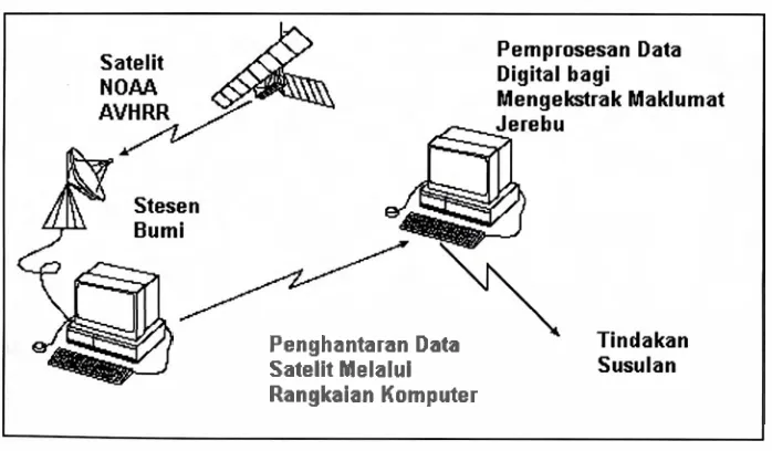
2002). Figure 1 shows an operational system for smoke haze detection system.
Penghantaran Data Satelit Melalul
[image:9.505.46.395.409.613.2]Rangkaian Komputer
Figure 1 : Operational of Smoke haze Detecting System
As the visibility of smoke being dominated by very tiny constituent known as
particulate matter sizing less than 10 micrometers in diameter or PMIO, thus this
reports focus on results of a study to determine PM 10 from NOAA-14
AVHRR
satellite data.
Data and materials used, technique employed and result obtained are
explained in detailed in the following sections. The performance of the techniques is
evaluated using suitable accuracy assessment method in the last part of this report.
3. Statement of Problem
(i) Existing smoke detection devices are incapable~f providing an early warning to
the public, time consuming especially for large area and expensive for
continuous monitoring.
(ii) Overlapping spectral signature of satellite measurements between smoke, clouds
and background surface.
(iii) It is critical for public to know daily typical regional drift pattern of smoke so
that immediate precautions can be carried out accordingly.
4. Approach
This study focuses in the 1997 thick smoke haze episode in Malaysia. However the
result are applicable for current and future use.
4.1. Materials
Three types of data namely; ground-truth data, satellite data and ancillary data will be
used.
4.1.1. Ground-truth data
Conventional measurements of smoke haze were complementarily used
messwements in micrograms per meter cube (pgm3) from lSt to 3oh September 1997
wge canied out by Alam Sekitar Malaysia Sdn. Bhd. (ASMA) to represent the actual
I haze intensity over the study area. For the purpose of this study, the PM 10
ooecentration in pgrnJ was later converted to AQI. AQI Calculator was used for this se 2006a). Some of the displays are shown in Figure 2 and Figure 3.
alculated using pollutant concentration data, the breakpoints in Table 1 ge, and the following equation (linear interpolation):
c
s the rounded concentration of pollutantg p = the breakpoint that is greater than or equal to C Him
pp
= the breakpoint that is less than or equal to C L,,,5
the AQT value corresponding to BP Hi HiI..
kf..
3 ' --
ooc-102 WI-$9'0 wo
-
soco vw- S'ZI nt. rsr VW-T'(KI4-n (WIL- ISI 6) mr'o