From Silos to Networks – Will Users Drive Spatial Data Infrastructures in
the Future?
Kevin MCDOUGALL, Australia
Key words: social networks, spatial data infrastructure, volunteered geographic information
SUMMARY
Spatial data infrastructures (SDI) have continued to evolve over the past 20 years from top-down policy driven initiatives to increasingly bottom-up approaches where lower levels of government are now active participants in building local SDI. Government mapping agencies at the national and state levels are now no longer willing to fund the ongoing cost of traditional mapping either in hard or digital formats. Cost recovery efforts by governments in the 1990s in Australia were generally unsuccessful and consequential changes to reduce government expenditure by shifting the costs across to the private sector soon followed. Spatial data infrastructures have moved to reduce the duplication of jurisdictional efforts whilst at the same time providing portals which promote the wider utilisation of spatial data across the community. Although government continue to have a major role in the ongoing development of SDI, it has become apparent that the driving forces are longer vested in the traditional government data custodians, but increasingly with the data users and value-adders.
From Silos to Networks – Will Users Drive Spatial Data Infrastructures in
the Future?
Kevin MCDOUGALL, Australia
1. INTRODUCTION
In recent years, it has become common to see the regular use of geographic or spatial information in research on a range of social issues. Perhaps one of the most significant and visible social impacts of spatial information was the release of Google Earth to the public in June 2005. The release of Google Earth caused an enormous increase in media attention on digital globes and a new awareness of the power of geographic information. Other common spatial portals such as Google Maps and Microsoft Virtual Earth are now used for a multitude of applications – from locating businesses to investigating holiday destinations. In-car navigation systems, which have been taken up in record numbers, rely on spatial information in the form of street networks and points of interest.
Even in the 1980s, it was estimated that approximately 70-80 per cent of government decisions had a geographic or spatial dimension, particularly in areas such as local or regional planning, land development, and planning for services or infrastructure. Spatial information has emerged from traditional cartographic and mapping representations that have gradually been transformed from paper-based maps and plans of all shapes and sizes to digital mapping products. Government and business are now significantly reliant on spatial information products and systems. These spatial products are increasingly integrated into information systems as part of governmental or business tools.
The majority of spatial information and mapping has traditionally been captured, managed and controlled by public sector agencies. Over the past decade with the value and potential of spatial information slowly being realised, and the gradual down-sizing of government mapping agencies, the private sector has now become a significant holder of spatial information. However, the mechanisms for the value- adding of spatial information are generally limited to one-way data flows and the creation of new silos within the private sector are now emerging. A range of institutional factors still limit the potential for sharing of spatial information across governments and the private sector, and hence, the further development of spatial data infrastructures at local and sub-national scales.
This paper explores the progressive development of spatial data infrastructures and the more recent phenomena that is become known as volunteered geographic information (VGI). The significant change in balance in the role of traditional government agencies and the increasing advocacy of private sector organisations and individuals in the collection and management of spatial data will inevitably have an impact on the development of future SDI models. It is proposed that future SDI models will move from being government centric to user driven models where private sector organisations and individuals will play a key role. This trend may challenge the role traditional mapping agencies and introduce higher levels of complexity within our current SDI models. The issues and opportunities in developing a network approach to SDI are discussed and the possible role of volunteered geographic information is examined.
2. SDI EVOLUTION
The evolution of the spatial or geographic data infrastructure concept can be traced back to the late 1980s when discussion on information infrastructures and the information superhighway was occurring. In 1987, The British Government Committee of Enquiry on the Handling of Geographic Information, chaired by Lord Chorley, identified the advent of GIS as ‘the biggest step forward in handling geographic information since the invention of the map” (Cited in Masser, 2005, p. 3). Although the recommendations by the Chorley Report, including the establishment of an independent geographic information management agency were rejected, it set the scene for subsequent discussion on SDIs in the UK, including the formation of the Association of Geographic Information (AGI) in 1989 and the National Geospatial Data Framework initiated in 1996 (Masser, 2005).
In the United States, the concept of a National SDI initially began in the academic communities around 1989 (Tosta, 1999), and soon after in government with the formation of the Federal Geographic Data Committee (FGDC) in 1990 by the Office of Management and Budget. During the early 1990s, the FGDC developed coordination strategies, standards and best practice with the objective of building “a national digital spatial data resource” (Reichardt and Moeller, 2000). A major study by the National Research Council in early 1990 further supported the development of a National Spatial Data Infrastructure (National Research Council, 1993). The National Information Infrastructure (NII) agenda proposed by the Clinton/Gore administration in 1993 was followed by the issuing of Executive Order 12096 in April 1994, which called for the establishment of a National Spatial Data Infrastructure as a key component of the National Information Infrastructure (Reichardt and Moeller, 2000). Similar developments were also underway in Canada around 1995 with a plan being developed for an integrated spatial data model for the country in 1995 which guided the creation of the Canadian Geospatial Data Infrastructure in late 1996 and the establishment of the government funded GeoConnections in 1999.
are financed by the member countries which contribute to the total budget for the annual work plan in a challenging organisational, political, legal and technological environment. In 2002, the Commission began preparing an initiative to stimulate the availability of geographic information, INSPIRE (INfrastructure for SPatial InfoRmation in Europe).
In Australia in the early 1990s, a number of state government agencies promoted the proposition that land and spatial information should be considered as an infrastructure (Davies and Lyons, 1991; Kelly, 1993). Australian efforts towards a National Spatial Data Infrastructure were promoted by ANZLIC in 1996, through a position paper on “Spatial Data Infrastructure for Australia and New Zealand” (ANZLIC, 1996). Coordination efforts by ANZLIC activated this vision through the development of policy, standards and metadata toolkits.
Masser (1999) identified those countries which were the early adopters of the SDI concept as the first generation of national spatial data infrastructures. He identified two basic drivers, for these developments namely: the growing importance of geographic information in the coming age of digital technology; and the need for some form of government intervention to coordinate data acquisition and availability. Both of these drivers continue to be important to SDI development, particularly the second driver, as the need for coordination continues to be a critical component of any inter-jurisdictional initiative. Crompvoets et al. (2004) characterise the second generation of SDIs by the change in focus of some of the early adopters (Australia, Canada and USA) including the updating of strategies and conceptual models. These authors believe that the second generation of SDI developments, commencing around 2000, fall into two groups: those first generation countries that are gradually updating and modifying their initiative and those countries that that have recently decided to design and develop their SDI.
The generational developments of SDI may also be examined from the context of either a product based model versus a process-based model (Rajabifard et al., 2002; Williamson et al., 2003). SDI has developed progressively from the early beginnings of land and geographic information systems into a coordinated approach to managing, collecting and distributing data. The first generation of SDIs were primarily driven by mapping agencies and their overwhelming need to coordinate the growing repositories of spatial data. These initiatives were largely product-based with the traditional focus on producing particular map products continuing into the digital age. With the greater maturity of these spatial data repositories, the focus began to shift from this product approach as leading nations in SDI development changed their strategies and updated their SDI conceptual models e.g. USA and Australia (Rajabifard et al., 2003). Approaches moved to be more “process focussed” and included people as an integral component of SDI and with a greater emphasis on the interoperability of data and resources. The concept of more independent organisational committees or partnerships representing different stakeholders is beginning to dominate SDI development.
sub-national and local levels (Masser, 2009). Local governments and municipalities who deal with large-scale, citizen focussed and operational data are increasingly seen by the community as both relevant and necessary. Importantly, it is the citizens and the growing number of non-spatial users that are now influencing the developments in SDI. The next generation of SDI is emerging where users will play a vital role for information management (Budhathoki et al., 2008; Rajabifard et al., 2006; Goodchild, 2008).
3. CHANGING ROLES: FROM PRODUCERS TO USERS
3.1 From Government to Private Sector
Like their national counterparts, sub-national governments are increasingly outsourcing their traditional data capture and management activities to the private sector. The transition from largely government dominated producers, distributors and users has moved at varying rates in countries around the world, with varying outcomes. In Canada, the Alberta Environment Protection outsourced the updating, storing and distribution of its digital map base by establishing a new company, Spatial Data Warehouse (SDW). The not-for-profit company, owned by a consortium comprised of different levels of government and the utility sector, underestimated the efforts required to maintain the data sets, and in 1998 set up a joint venture arrangement with a private sector firm to manage the data (Masser, 2005).
The private sector’s role in SDI development in Australia is ongoing. Initially, the private sector’s involvement began in the mid 1990s as a data collector when government mapping services were outsourced. Progressively private businesses are now specialising not only in the collection but also in the on-going maintenance of government databases. More recently however, the private sector involvement has included marketing and value-adding. This engagement has brought with it challenges for government to balance their control of their information investments with the need to encourage spatial business opportunities.
In the UK, the Ordnance Survey has continued to transition from a government operated department to a full commercial enterprise. Its success or otherwise may be viewed from different standpoints as its road to commercialisation progresses. However, there is little doubt that the move from the public to commercial sector environment has facilitated a significant change in its focus, relationship with government agencies and importantly the community of end-users. A recent strategy announcement (April 2009) by the Ministry of Housing which oversees the Ordnance Survey identified a number of user and community driven initiatives including:
− Promoting innovation - with an enhanced free service to allow experimentation with digital information and a clear path from this service to greater commercialisation; − Reforming Ordnance Survey's licensing framework - so that it is much simpler to use
Ordnance Survey data and services in other applications;
− Supporting the sharing of information across the public sector - to enable better public policy and services; and
− Creating an innovative trading entity - to explore further commercial opportunities around Ordnance Survey data and services. (http://www.ordnancesurvey.co.uk)
In developing countries the growth of SDI initiatives has varied depending on available infrastructure and the role of key individuals. However, in contrast to the silo approach that has held back many developing countries, developing countries have the opportunity to develop their SDI strategy from the beginning. An analogy exists in this context with the telecommunications infrastructure in developing countries. Rather than installing individual fixed lines to houses, most developing countries have jumped directly to mobile phone technology as the preferred solution.
As the various SDI frameworks have matured, there has been a greater recognition of the role of partnerships (McDougall et al., 2005; Warnest et al., 2003), particularly at the sub-national and local levels. Inter-jurisdictional efforts to build SDIs are now more dependent on spatial data sharing in an organised and sustained manner. Formal partnership initiatives are therefore becoming an essential element of the framework of an SDI and increasingly provide a mechanism to clarify and define the institutional arrangements component of the SDI. Inter-jurisdictional partnerships primarily occur between agencies in levels of government such as local-state, state-national. Intra-jurisdictional partnerships involve any parties at the same level of government that share a common goal of creating, maintaining, utilising and distributing spatial information for the delivery of government services. They have emerged as structures which facilitate the interactions required to share information and hence to build SDIs. While much of the focus of partnerships for SDI development continues to be in government, the complete vision of SDI development will only be realised through the cooperation and collaboration between the public and private sectors.
3.2 Volunteered Geographic Information (VGI)
In the past few years the information infrastructure (primarily facilitated through the internet), the growth publicly available spatially enabled applications (such as Google Earth) and accessible positioning technology (GPS) have combined to enable users from many differing and diverse backgrounds to share geographically referenced information. This information has been termed by Mike Goodchild and others as volunteered geographic information (VGI) (Goodchild, 2007; Kuhn, 2007). Volunteered information in the broader context has been facilitated by the ability of web platforms to accept and to organise information in a form that is accessible to others. It may be provided as a read only type access or be subject to update, change or modification such as we see in the Wiki environments. Most of this software functionality has emerged in the past 5-7yrs which is really quite a remarkable achievement.
features and location with relative ease. The other primary source of geographic locations which are volunteered comes through the coordinates generated through the Global Positioning Systems (GPS) receivers which are now found in a range of electronic entertainment and communication devices. Personal navigation devices or PNDs have grown dramatically in the past few years as both the technology and the availability of street network data has matured.
Volunteered geographic information represents a new and rapidly growing resource which has already illustrated a myriad of uses. Its near real-time capability has been utilised in the emergency and disaster management environments to broadcast the conditions and situation on the ground. In the absence of other rapid response mapping which invariably is delayed by days or even weeks, VGI may become critical. VGI is also proving to be valuable where traditional sources of fundamental spatial information does not exist or not publicly accessible.
4. SHARING INFORMATION THROUGH SOCIAL NETWORKS
[image:7.595.200.393.456.594.2]A social network is a network of nodes formed through relationships that may have been established through friendship, ideas, values, hobbies or other linkage mechanisms. Social networking theory is the study of these networks and the mapping of these relationships as they may apply to wide range of human organisations, from small groups to entire nations (Ethier, 2009). Understanding of the connections between individuals can be used to evaluate the social capital of the various individuals within the network. The greater the number of connections that a person has is generally indicative of the knowledge, power and influence of an individual (see Figure 1).
Figure 1: Mapping a Social Network
(Boudourides, 2002). Citizen participation in social networking forums such as Facebook, Myspace, Friendster and others has grown dramatically in the past few years with many having over 100 million listed members.
Social networking has been identified by a number of industries and organisations as a potential contributor to a range of areas including innovation, building staff networks, solving complex problems or extending the market reach of products. By its very nature, social networking involves a series of one to one or one to many connections that require the active participation of individuals. This process of active participation can consume large amounts of time for individuals and may not be the most productive way to achieve a particular task within an organisation. Most of these systems are standalone systems that are often outside of the normal business infrastructure which can prove to be problematic. Businesses would rather restrict their information to internal clients for a variety of reasons (security, confidentiality etc) and would prefer a system that was integrated within their existing business relationship management systems rather than outside of the business.
IBM launched an internal social networking site for employees in 2007 which was designed to blur the boundaries of work, home, professional, business and fun (DiMicco et al., 2008). The system, which was called Beehive, was hosted as an experimental platform for studying the adoption and usage of social networking in the workplace. Initial findings indicate that the value to employees include being able to promote ideas more effectively and to build their social capital within the organisation.
Social networking communities comprise of a range of individuals and groups with a common interest. The spatial information society may, to some extent, be considered to be a small subset of the larger social networking community and hence the potential to communicate spatial change and information might not be considered significant. However, spatial information technologies such as GPS and personal navigation devices such as GPS enabled mobile phones and vehicle navigation systems now bring spatial capabilities within the reach of a large proportion of the wider community. This trend is set to increase to continue. The characteristics of social networks and the trends in the use of Web 2.0 and positioning technologies therefore requires some further understanding and insights.
5. DISCUSSION
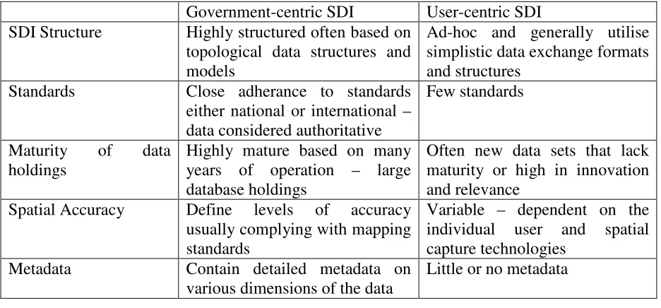
The change from the early SDI developments which were government focussed to a user-centric SDI developments, such those now seen in developments such as Openstreetmap, Wikimapia and a range of mashups, may be best illustrated in Table 1.
With increasing demands and declining resources, volunteered geographic information may present a potential opportunity for mapping agencies and the future development of SDI. Although VGI may not be readily suitable or appropriate for contributing to the fundamental data sets at the national level, opportunities exist for contributions at sub-national or local levels.
Within the private sector, open source software is becoming an important part of their ongoing data maintenance and development. The use of VGI for the update of street address and street networks is an area where there has been immediate application. Companies such as Navtek and Tom Tom have web based interfaces to take user input to changes in the street network database. VGI provides a relatively good fit to their business models and operations because multiple notifications can be triggered to address a particular database error. Users are also provided feedback on their contributions.
[image:9.595.65.533.484.702.2]In local government, web mapping interfaces are becoming increasingly common to accept citizen input on a variety of issues. Examples include the identification of potholes in local roads, areas of need for footpath maintenance, dumped cars, vandalism and suggestions for new planning initiatives. The Ordnance Survey has moved to take advantage of the potential of Web 2.0 software developments with a product called OS OpenSpace. The software enables access to Ordnance Survey’s mapping base to encourage and promote innovative use of geographic information. It is free for non-commercial and private use and ideally suited for the developments by citizens and communities.
Table 1: Comparison of Government versus User Centric SDI
Government-centric SDI User-centric SDI SDI Structure Highly structured often based on
topological data structures and models
Ad-hoc and generally utilise simplistic data exchange formats and structures
Standards Close adherance to standards either national or international – data considered authoritative
Few standards
Maturity of data holdings
Highly mature based on many years of operation – large database holdings
Often new data sets that lack maturity or high in innovation and relevance
Spatial Accuracy Define levels of accuracy usually complying with mapping standards
Variable – dependent on the individual user and spatial capture technologies
Metadata Contain detailed metadata on various dimensions of the data
Openness Highly controlled with the degree of access and openness to the public limited.
Open access to view and enter data – Web 2.0
Data Update Often slow and overly bureaucratic
Fast and flexible
Potential data maintenance and collection base
Limited to the budget and staffing resources of the organisation
Potentially a huge user and contributor base
Adaptability Low – retrained by mandate, resources and bureaucracy
High
However, progress in the more traditional mapping agencies and government departments has been, to date, limited. The institutional inertia, bureaucratic process and limited mandate has to a large extent restricted developments and innovation within the public sector. This may only be a temporary as governments come to the realisation of the importance of opening up their information repositories and re-visiting their core mandate which is providing a service or public benefit to the community. A number of possible opportunities exist across government and it is expected that cautious progress will eventuate.
6. CONCLUSION
SDI development is now part of government and private sector activities in over half the countries around the world. SDI development has moved from national levels and policy making to sub-national levels where the focus is the generation of products. Different models to represent SDI have emerged which reflect the differing goals of SDI developers around the world. The progressive move from the SDI developments at the producer level to the user level will have a major influence on the future SDI designs and models.
The massive impact that has occurred through Web 2.0 in the form of user interaction and social networking represents an evolutionary change in control from traditional spatial experts to the end users. There is no doubt that high quality SDI will continue to provide the foundation of spatial information for the foreseeable future, however the wisdom of crowds and innovation of users will increasingly drive our next generation of SDIs.
REFERENCES
ANZLIC. (1996, November, 1996). Spatial data infrastructure for Australia and New
Zealand, [ANZLIC Discussion Paper]. Available:
http://www.anzlic.org.au/asdi/anzdiscu.htmApril, 2002].
[image:10.595.66.533.70.216.2]Budhathoki, N. R., Bruce, B. and Nedovic-Budic, Z. (2008), 'Reconceptualizing the role of the user of spatial data infrastructure', GeoJournal, Vol 72, No. 149-160.
Crompvoets, J., Bregt, A., Rajabifard, A. and Williamson, I. P. (2004), 'Assessing worldwide developments of national spatial data clearinghouses', International Journal of Geographic Information Science, Vol 18, No. 1, 1-25.
Davies, K. and Lyons, K. (1991), Micro-economic reform, land administration and land information management. Paper presented at the Conference on Land Information Management, 10-11 July, 1991, Sydney, Australia, pp. 87-95.
DiMicco, J., Millen, D., Werner, G. and Casey, D. (2008) In CSCW'08 Workshop on Social Networking in OrganisationsSan Diego, California.
Ethier, J. (2009), Current Research in Social Networking Theory. Available:
http://www.ccs.neu.edu/home/perrolle/archive/Ethier-SocialNetworks.html, accessed 20 January 2009.
EUROGI. (2005). EUROGI Website - Rationale, Mission and Objectives of EUROGI. Available: http://www.eurogi.org/index_1024.html [2006, 8 March].
Goodchild, M. F. (2007), 'Citizens as sensors: the world of volunteered geography', GeoJournal, Vol, No. 69, 211-221.
Goodchild, M. F. (2008), 'Commentary: whither VGI?' GeoJournal Vol 72, No. 239–244.
Kelly, P. (1993), A National Spatial Information Infrastructure. Paper presented at the Conference of the Australian Urban and Regional Information Systems Association, 22-26 November, 1993, Adelaide.
Kuhn, W. (2007) In Volunteered Geographic Information WorkshopNCGIA, UC Santa Barbara.
Masser, I. (1999), 'All shapes and sizes: the first generation of national spatial data infrastructures', International Journal of Geographic Information Science, Vol 13, No. 1, 67-84.
Masser, I. (2005), GIS worlds - creating spatial data infrastructures, ESRI Press, Redlands, CA.
Masser, I. (2009), Changing Notions of a Spatial Data Infrastructure. Paper presented at the GSDI 11, 15-19 June 2009, Rotterdam, Netherlands.
International Conference on Global Spatial Data Infrastructures (GSDI 8), 16-21 April, 2005, Cairo, Egypt.
National Research Council (1993), Toward a coordinated spatial data infrastructure for the
nation, National Academy Press, Washington DC.
http://www.nap.edu/catalog/2105.html
Rajabifard, A., Binns, A., Masser, I. and Williamson, I. (2006), 'The role of sub-national government and the private sector in future spatial data infrastructure', International Journal of Geographical Information Science, Vol 20, No. 7, 727-741.
Rajabifard, A., Feeney, M.-E. F., Williamson, I. and Masser, I. (2003), 'National SDI Initiatives' In Developing Spatial Data Infrastructures: From Concept to Reality (Eds, Williamson, I., Rajabifard, A. and Feeney, M.-E. F.) Taylor & Francis, London, UK, pp. 94-110.
Rajabifard, A., Feeny, M.-E. and Williamson, I. P. (2002), 'Future Directions for SDI Development.' International Journal of Applied Earth Observation and Geoinformation, Vol 4, No. 1, 11-22.
Reichardt, M. and Moeller, J. (2000), SDI Challenges for a New Millennium NSDI at a Crossroads: Lessons Learned and Next Steps. Paper presented at the 4th Global Spatial Data Infrastructure Conference, 13-15 March 2000, Cape Town, South Africa.
Tosta, N. (1999), 'Chapter 2: NSDI was supposed to be a verb: A personal perspective on progress in the evolution of the U.S. National Spatial data Infrastructure' In Integrating Information Infrastructures with GI Technology: Innovations in GIS 6 (Ed, Gittings, B.) Taylor and Francis, Philadelphia.
Warnest, M., McDougall, K., Rajabifard, A. and Williamson, I. P. (2003), Local and State-based collaboration: the key to unlocking the potential of SDI. Paper presented at the Inaurgural Conference of the Spatial Sciences Institute, CD ROM, 22-26 September, 2003, Canberra.
BIOGRAPHICAL NOTES
Kevin McDougall is Head of Surveying & Spatial Science in Faculty of Engineering and Surveying, University of Southern Queensland, Australia. Kevin has a Doctor of Philosophy from University of Melbourne and more than 25 years of professional experiences and approximately 100 scientific publications. Kevin has worked in a number of developing countries including the Philippines, Indonesia, South Pacific Island and Palestine on land administration and management. Kevin’s research interests include are land administration, SDI, VGI and spatial data sharing.
CONTACTS
Associate Professor Kevin McDougall Head, Surveying and Spatial Science Faculty of Engineering and Surveying University of Southern Queensland
West Street, Toowoomba, Queensland 4350 Australia AUSTRALIA
Tel. +617 4631 2545 Fax + 617 4631 2526
E-mail: [email protected]