THESES SIS/LIBRARY TELEPHONE: +61 2 6125 4631
R.G. MENZIES LIBRARY BUILDING NO:2 FACSIMILE: +61 2 6125 4063
THE AUSTRALIAN NATIONAL UNIVERSITY EMAIL: library.theses@anu.edu.au CANBERRA ACT 0200 AUSTRALIA
USE OF THESES
This copy is supplied for purposes
of private study and research only.
Passages from the thesis may not be
copied or closely paraphrased without the
'
DRYLAND SALINITY
-IN THE SOUTH-EAST REGION
NEW SOUTH WALES
Rex Wagner
.... ···,.
A thesis submitted for the degree of Master of Resource and Environmental Studies
at the Australian National University
Disclaimer
Except for where indicated otherwise, this thesis is entirely my own work.
- R. Wagner
October 2001
--Acknowledgements
After taking such an extended time to complete my studies and having received
assistance from so many people along the way, it would be difficult to say thanks to
everyone.
Initially I would like to thank Professor Henry Nix, Valda Semets, Dingle Smith and
the late Ian Moore for introducing me to CRES; with special thanks to Dingle Smith
as my first supervisor.
More recently, I would particularly like to express my sincere gratitude to my present
supervisor, Professor Ian White, for his support and guidance. Also, I would like to
thank Professor Bob Wasson for his interest in the study, and Dr Stephen Dovers, Dr
Fred Ghassemi and Dr Sara Beavis for their encouraging advice and suggestions.
Special thanks are also due to Kathy Hicks, Office Manager, Water Research Foundation of Australia, for her assistance during the course of my studies, and in
producing the final document. Thanks also, to Dorothy Nash, Sue Kelo and Sandra
Mitchell for their computer and editing assistance.
Outside of CRES, but within the ANU, I would like to thank Bob Cooper
(Photography, RSSS) and Chris Palmer {ANU Graphics). With a thesis so heavily
dependent on good photographies, their help and advice was of great assistance.
Within the South-East Region I would like to thank many landholders, who were
prepared to discuss the salinity problem with me. Special gratitude is due to the late
Aubrey Walmsley (Glencoe) Murrumbateman, who was able to provide much
information on the early settlement in the Yass Valley, first evidence of a salinity
problem, and the early reaction to it.
Finally I would like to thank the staff of the Department of Conservation and Land
Management, NSW, and NSW Agriculture within the region, for their ready
Abstract
Dryland salinity is claimed to be potentially the nation's greatest environmental
problem. In NSW, it occurs mainly in the upland areas in the south-east of the State.
This region is part of the Murray-Darling Basin and has the potential to contribute to
its worsening salinity. This thesis examines the nature of its occurrence in this area,
and the implications for its remediation.
There are two opposing models of the causes of dryland salinity. The first, a more
long held view, is that salinisation is localised, restricted to particular soils and
landforms, restricted in its spread, episodic in its development, and responsive to
mitigation measures within its own local catchment or recharge area. A more recent
view is that the problem is one of regional dimension, driven by rising regional
groundwater systems, progressive in its spread, and having the potential to degrade
large areas with serious off-site consequences, principally as a result of increasing
stream salinity. Here, the genesis of the problem is seen as the widespread clearing of
timber in regional recharge areas following European settlement. The chief remedy
proposed is to restore tree cover; with up to 50 percent of the higher rainfall zone in
the Murray-Darling Basin being replanted to trees.
The opposing models differ greatly in their conception of the magnitude of the
problem, and its potential for expansion. They present widely different management
and policy options for its mitigation. The social and economic impacts of any
programs proposed similarly differ.
This thesis uses aerial photography, site inspections, and farmer interviews to trace
the development of dryland salinity in the south-east region of NSW. The findings
are compared with the expectations from the two models.
It was found that dryland salinity across the region was not a recent phenomenon. One site developed before 1900 and there were episodic periods of expansion in the
1930s and 1950s to 1960s, with most sites reaching their maximum extent by the
early 1970s. Most sites occurred as isolated outbreaks, associated with local
landscape features and soil types. Their development appeared to be closely related to
changes in rainfall patterns, to past land use and management of the affected sites
themselves, and their local recharge areas. There was no evidence of continued
either spatially or temporaly, as projected from regional watertable modelling.
However the conditions that predispose lands to dryland salinity still exist, and there
could be an extension of the problem in the future.
. In
a limited number of cases, rehabilitation of former saline areas has been achieved
at the local property level. Here the landholders
hadbroader objectives than solely
controlling salinity. Their primary objectives were
todevelop more productive and
sustainable farming systems. The improved practices introduced also overcame other
associated land degradation problems. These measures, at a local recharge level, were
effective within a reasonably short time. Although long
termregional programs may
be needed, the study showed that many of the incidences of local salinity
development appear to be associated with local factors. Successful treatment at a
local property level appears to confirm this. Such treatments have the potential to
reduce salt flushes from farm lands to streams. The success of these treatments is not
consistent with the regional groundwater model. Tree planting on the scale proposed .
from this model, may not be necessary; and the development and adoption of more
sustainable farming systems widely across landscapes may largely redress the
situation. These systems in themselves would include more trees. This approach
would not require the huge capital investment necessary with tree or engineering
solutions. The necessary treatments would be more within the reach of individual
landholders, and would be much less disruptive to the existing agricultural
infrastructure and community
lifethan the massive tree planting programs proposed,
and may ensure a better allocation of resources overall. More support at the local
community level should also be achievable.
Dryland salinity is a symptom as well as the result of unsustainable land use and
management.
Itis concluded that reduction in the hazard does not depend on· a
singular approach such as tree planting, but principally on the development and
adoption of more sustainable and productive farming systems. Technology is ~eing
developed that could provide the basis for such systems. Means also must be
Table of Contents
1 INTRODUCTION ... 1
1.1 SEITING THE SCENE ... 1
1.2 DEFINIDON OF DRYLAND SALINITY ... 2
1.3 NATURE OF THE PHENOMENON ... .3
1.4 MAGNITUDE AND EXTENT OF DRYLAND SALINITY ... 5
1.5 Two MODELS OF DRYLAND SEEPAGE SALINITY ... 6
1. 6 AIMS OF THIS THESIS ... 7
2 DRYLAND SALINITY •..•••.••••••.•...••.•...•.•.•.••••••••..•••.•.•.••.•.••••...•.••.••.•.•••••...•...•....•.••...•..•. 9
2.1 IMP ACT OF SALINITY ON PLANTS ... 9
2.2 SOILS AND SALINITY ... 9
2.3 THE HYDROLOGIC CYCLE ... 11
2.4 DRYLAND SALINITY IN AUSTRALIA ... 13
2.4.1 Western Australia ... 13
2.4.2 Victoria ... 21
2.4.3 New South Wales ... 26
2.5 RECENT RESEARCH: - RELEVANT TO THE SOUTH-EAST REGION OF NSW ... .49
2.6 DRYLAND SALINITYINTHEMURRAY-DARLING BASIN ... 58
2.7 GENERALDISCUSSION ... 60
2.8 CONCLUSIONS FROM THE REVIEW ... 67
3 DRYLAND SALINITY IN THE SOUTH-EAST REGION OF NSW .••••••.•...•.•.•.•...••.•....• 68
3.1 THESTUDYAREA(FIG. 3.1) ... 68
3.2 OCCURRENCE OF DRYLAND SEEPAGE SALINITY IN THE SOUTH-EAST REGION ... 68
3.3 DEVELOPMENT OF DRYLAND SALINITY WITHIN THE SOUTH-EAST REGION ... 74
3.4 CASE STUDIES .•...•.•.•..•...•... 80
3.4.1. Upper Lach/an River Catchment ... 83
3.4.l.l Bevendale-Blakney Creek area ... 83
Case Study Site No. l. 'Dunleys' Blakney Creek ... 89
Case Study Site No. 2. 'Daleys Creek' Blakney Creek ... 92
Case Study Site No. 3. 'Denbeigh Grove' Bevendale ... 98
Case study sites No. 4, and No. 5. - Bevendale ... l 02 3.4.1.2 Upper Lachlan River Catchment: Rugby-Rye Park Area ... l 06 Case Study Site No. 6. Gorham 'Beltana' Rubgy ... 108
Case Study Site No. 7. R. Collins 'Tiwarie' Rugby ... : ... 111
Case Study Site No. 8. 'Begalia' Yass ... 113
3.4.1.3. Upper Lachlan Catchment- Boorowa River Sub-Catchment ... 116
Case Study Site No. 9. "Hillrose" Boorowa. ... 119
Case Study Sites No. IO & No. 11. 'Kenilworth' Binda ... 125
3.4.2. Upper Murrumbidgee Catchment- Yass River Sub-catchment ... 127
Case Study Site No. 12. Whites Dicks Creek Site-'The Opening Site' ... 130
Case Study Site No. 13. Williams Creek Site ... 133
Case Study Site No. 14. A. Walmsley 'Glencoe' Murrumbateman ... 135
3.4.3. The Upper Warragamba CatchmentArea ... 140
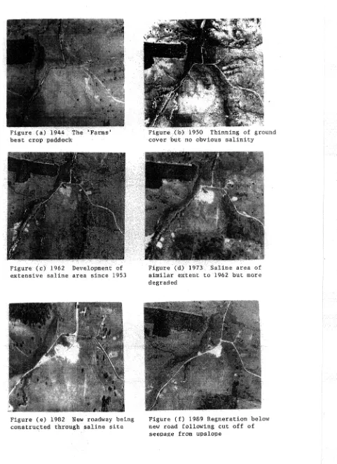
Case Study Site No. 15. Crisps Creek Sub-catchment. - Figure 3.22 (a-e) ... 141
3.4.4. Upper Shoalhaven Catchment. - South-East Region ... 147
Case Study Site No. 16. The 'Y arralaw' Site ... 149
Case Study Site No. 17. 'Inverary Park' Bungonia ... 153
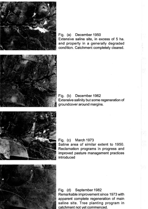
Case Study Site No. 18. 'Millended Springs' - Boro ... 157
Case Study Site No. 19. Near Little Burney Forest, Braidwood ... 162
4. CONCLUSIONS FROM CASE STUDIES ... 170
4.1 THE GEOGRAPHIC OCCURRENCE OF DRYLAND SALINITY IN THE REGION ... 170
4.2 CHRONOLOGY OF SALINITY DEVELOPMENT ... 171
4.3 NATUREOFDRYLANDSALINITY0UTBREAKS ... 171
4.4 RAlNF ALL AND SALINITY DEVELOPMENT ... 172
4.5 LANDFORM AND SALINITY ... 173
4.6 SOILS ... 174
4.7 GROUNDWATERSOURCES ... 175
4.8 GEOLOGY ...••••... 176
4.9 SALINITY ANDEROSION ... 176
4.10 VEGETATIONANDSALINITY ...•... 177
4.11 LANDUSEANDMANAGEMENT ANDSALINITY ... 178
4.12 MmGATIONOFSALINITY ... 179
5 DEVELOPMENT OF SALINITY ABATEMENT PROGRAMS ... 181
5.1 VEGETATION MANAGEMENT AND SALINITY ABATEMENT ... 181
5.1.1 Trees ... 184
5.1.2 Grassland management ... 188
5.1.3 Crop production ... 191
5.2 DEVELOPMENTS IN TREATING DRYLAND SALINITY ... 193
5 .3 COST OF DRYLAND SALINITY ABATEMENT ... 195
5.4 FARMERS' PERSPECTIVES ON SALINITY ... 197
5.5 STREAMSALINITY ... 201
5.6 RESEARCHANDINVESTIGATION ... 203
6 CONCLUDING REMARKS ... 206
7 REFERENCES ... 210
List of Tables
Page
1.1 Extent of dryland seepage salinity- Australia ('000 ha). 6
2.1 Criteria for salinity, sodicity and alkalinity (adapted from 10
Northcote and Skene, 1972)
2.2 Land degradation NSW 1987-88. Soil Conservation Service 26
ofNew South Wales, 1988
3.1 Dryland salinity: South-East Region NSW. Soil Conservation 69
Service of NSW, 1988
3.2 Rainfall and salinity, South-East Region NSW (Wagner 1986) 69
3.3 Dryland salinity, South-East Region NSW. Development of 75
saline sites 1941-43 to 1986, total of 94 sites (after Wagner
1987, revised 1994)
3.4 Size ofDryland Saline Sites, South-East Region. (After 78
Wagner, 1986).
3.5 Case stµdies South-East Region- Summary of Observations 165
List of Figures
Page
1.1 The effects of salting on the soil (Logan, 1958) 4
2.1 The components of the basin hydrological cycle (More, 1969) 12
2.3 New South Wales Dryland Salinity Hazard Map (Bradd, 1995) 32
2.4 Rainfall at Y ass. Yearly data 1899-1992 (Bradd and Gates, 57
1993)
3.1 Map of New South Wales showing location of the South-East 70
Region (Soil Conservation Service of NSW, 1986)
3.2 Map of the occurrence of dry land salinity in the South-East 72
Region, NSW (Soil Conservation Service of NSW, 1987)
3.3 Map of areas affected by dryland salinity in the South- East 73
Region in relation to the occurrence of Ordovician meta
sediments (Soil Conservation Service ofNSW, 1987)
3.4 Map showing general location of case study sites within the 81
South-East Region, NSW.
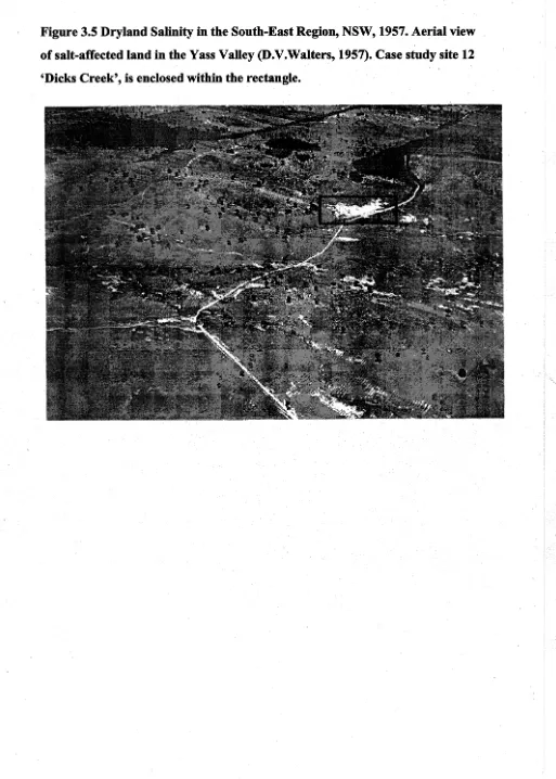
3.5 Dryland salinity in the South-East Region 1957. Aerial view of 82
the Yass Valley (Walters, 1957).
3.6 Bevendale-Blakney Creek. Relative extent and geomorphic 85
pattern of salinity development (Compare with Fig.3. 7)
3.7 Y ass Valley. Relative extent and geomorphic pattern of salinity 86
development.
3.8 Map showing location of case study sites - Upper Lachlan River 88
Catchment. . ·. '·
3.9 'Dunleys' site. Blakney Creek 91
3.10 Daleys Creek site. Bevendale 96
3.11 Daleys Creek site,·Bevendale. Aerial view June,1986 97
(R.Wagner)
3.13 Bevendale case study sites No.4 and No.5, showing the effects 104
ofland use and management on salinity development and site
rehabilitation
3.14 Bevendale. Aerial views showing the influence of land use and 105
grazing management on salinity development and rehabilitation,
June, 1986. (R. Wagner)
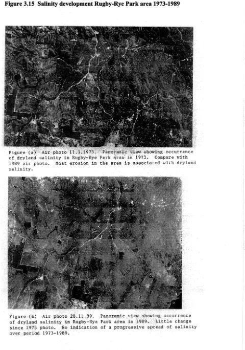
3.15 Salinity development Rugby-Rye Park area 1973-1989 107
3.16 Gorhams 'Beltana' Rugby saline area 110
3.17 R. & R. Clark 'Hillrose" Boorowa saline site 121
3.18 Map showing location of case study sites - Y ass River 129
Catchment
3.19 Whites 'Dicks Creek'; the 'Opening' site and Williams Creek 132
site
3.20 A. Walmsley 'Glencoe' Murrumbateman saline site 138-9
3.21 Map of Upper Warragamba Catchment showing location of case 140
study site within Crisps Creek sub-catchment
3.22 Dryland salinity Crisps Creek sub-catchment Tarago - Upper 144-6
Warragamba Catchment
3.23 Map showing location of case study sites - Upper Shoalhaven 148
Catchment
3.24 The 'Yarralaw' saline site Yarralaw - Upper Shoalhaven 151
Catchment
3.25 The 'Yarralaw' site October,1991. Subdivision for rural retreat 152
development taking place.
3.26 'Inverary Park' saline site Bungonia- Upper Shoalhaven 155
3.27 'Millended Springs' saline site - Lower Boro - Upper 159
Shoalhaven Catchment
5 .1 Water balance observed in field trials for a poor wheat crop 193
(2t/ha) and a good crop ( 4t/ha) grown on the same rainfall
-Dryland salinity 5 - Salt Action NSW, June 1993
5.2 Ranking of farm problems. Farmers' perceptions of dryland 199
salinity in the southern NSW wheatbelt (Dunn and Grey, 1992)
1 INTRODUCTION
1.1 Setting the Scene
Dryland salinity has been referred to as potentially the nation's greatest
· environmental problem (Soil Conservation Service ofNSW, 1988). In the uplands of
south-eastern NSW, concern is highlighted by the fact that the problem mainly occurs
in part of the headwaters of the Murray-Darling Basin, and has potential to contribute
to a worsening salinity in streams. The headwaters of streams forming part of the.
Sydney water supply catchment are also affected .
. Most of the affected lands lie within the South-East Region of the former Soil
Conservation Service of NSW, and in this thesis, studies have been confined to this
region (Fig. 3.1). Earlier studies (Soil Conservation Service ofNSW, 1988) showed
the total area actually affected by salinity within the region is quite small. The
problem is confined to its northwestern section and within this area significantly less
than one percent (0.49 percent) of the total area is affected by salinity. It is more
concentrated in the Yass Valley, where a little more than one percent (1.2 percent) of ·
land is affected (Nicoll & Scown, 1993).
Until recently, the problem was largely seen as one of a localised nature, restricted in
its spread and responsive to measures for its mitigation within its own local
catchment or recharge area. Outbreaks of salinity were linked to particular periods,
leading to the perception that it was largely episodic. As only small areas were mostly
affected, the problem was often ignored or perhaps went unrecognised.
Over recent decades, a different model of dryland salinity has been presented. In it,
salinity is driven by rising regional or deep groundwater systems, is progressive in its
spread, and has the potential to degrade large areas with serious off-site
consequences, principally through contributing to stream salinity. It is largely seen as ·having its genesis in the widespread clearing of timber in regional recharge areas
following European settlement. The chief remedy proposed is to restore this tree
cover. Models have been developed which suggest that within the Murray-Darling
Basin, 30-50 percent of the upland areas in the 600-800mm annual rainfall zone
should be replanted to trees. The models rely on the single measure of restoring trees
agricultural zone would be taken out of production. None of the current fanning
systems, even at the best level of practice, are considered capable of reducing
leakages to groundwater, sufficient to prevent dryland salinity. The scale ofland use
change needed to address the hydrological imbalance is seen as beyond current
resources, and raises other dilemmas, including trading off salinity and water )'ield
(Murray-Darling Basin, Salinity Audit, 1999). This model is challenged in this study.
The target area proposed for replanting includes all of the area of this study falling
within the Murray-Darling Basin. More than 90 percent of this area within the Basin
has been cleared for agriculture, principally grazing. As well, it has been suggested
that such recharge control options are likely to have only limited results in any
reasonable time scale, and either engineering options must be adopted, or we will ·
have to live with salt over large areas (Walker, 1997).
1.2 Definition of Dryland Salinity
In this thesis dryland salinity is defined as the concentration of salts under dryland. conditions in surface horizons, or at the soil surface itself, sufficient to inhibit or ·
prevent plant growth and adversely affect the physical and chemical properties of the
'
soil itself. Dryland salinity as it occurs in the South-East Region, NSW, is defined by.
the Report of the Working Party on Dryland Salinity in Australia, (1982), as induced
topsoil salinity (Type 4:1). It is induced in the sense that lands have become saline as
a result of land use changes since European settlement. As defined, the occurrence of
· this form of salinity is associated with the presence of a saline watertable which rises
periodically within capillary reach of the soil surface. The presence of a watertable
has been used to distinguish this form of dryland salinity from that occurring in more
arid areas, and is frequently referred to as 'scalding'.
Bullock (1986) noted the ambiguity in the Australian terminology used to describe
salt-affected lands, particularly in regard to the term 'scalding', which may be used to ·
describe denuded surface conditions, either in the presence or absence of a
watertable. He suggested that the term 'seepage scald' be used to oover all areas that
are a result of groundwater discharge, and that the term 'dry scald' be reserved for
those saline areas not affected by groundwater discharge.
The term 'dryland salinity' is simply used to describe all forms ofland degradation
1.3 Nature of the Phenomenon
Dryland salinity may predispose lands to subsequent problems such as soil erosion,
contribute to stream salinity and poor water quality, and reduce the stability of
structures in the built-up environment. In this study, the principal concern is the
degrading effects on agricultural lands and the associated environments.
Northcote and Skene (1972), noted that many factors determine the soil levels of
salinity, alkalinity and sodicity that affect plant growth. These include: the
composition of the salts; the moisture regime of the soil; nutrient status and
mechanical composition of the soil profile; and the particular rooting habit, age and
tolerance, both to the total salts and to specific ions in the soil solution of plant
species. Management practices imposed on the soil and the crop also have their
influence.
Other adverse properties of sodicity and alkalinity may develop following soil
salinisation and may remain even when the soluble salts have been removed.
However, salinity problems in the South-East Region ofNSW appear more related to
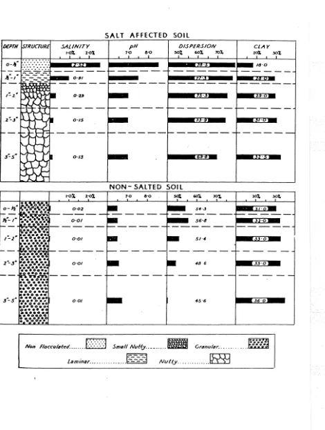
Figure 1.1 The effects of salting on the soil (Logan, 1958)
o-~-....
,,,_-/SALT AFFECTED SOIL
SALINITY pH DISPERSION
1-0~ 2·0% 7-0 11-0 502; 60% 70~
NON- SALTED SOIL
7·0 &·O
Non Floccu/4ted ... f:-:·:-:-:-:1 Small Nutty .. _______ _ Cr4nular. .... . . l am1nar .. _ ... ____ - - -.
E---~
Nvtty ...~
4
CLAY
The combined effects of salinity on soils and plant growth result in:
• Reduced plant growth and denuded landsurfaces which have reduced capacity
to use available moisture;
• A highly deflocculated powdery and dispersible topsoil very vulnerable to
erosion.
• Exposed highly impermeable surface horizons with reduced infiltration,
which increases surface runoff, and reduces redistribution of salts down the
profile; and
• Perched watertable conditions above impervious soil horizons with high
salinity levels and high pH levels in surface horizons.
Off-site effects include increased stream salinity and sediment load.
Salts accumulate as a function of a number of interrelated factors. These include the
salt content of the groundwater, the rate of capillary movement of groundwater to the
surface, the rate of evaporation, the amount of water percolating down through the
profile, and recharge. Groundwater does not have to be high in salt, as evaporation
can readily concentrate it to toxic levels in surface horizons. Groundwater levels
may intersect the soil surface or come within capillary fringe/range, generally within
2 metres of the surface (Nulsen.1981 ), or groundwater pressures may be sufficient to
overcome relatively impermeable conditions in its upward movement through the
profile. In a well-drained soil, rainfall infiltration may be sufficient to prevent the accumulation of salt in surface horizons. Conversely, however, periods of wet years
raise groundwater levels and predispose susceptible areas to salinity.
There has long been an awareness for the need to restore the hydrological balance of
catchments to mitigate salinity problems. In the past, most problems have generally been assessed and treated at a local level. In addition to the above factors, it was frequently observed that geological and topographical influences may bring the
watertable close to the surface in certain situations, and set limits to the area of
recharge.
1.4 Magnitude and Extent of Dryland Salinity
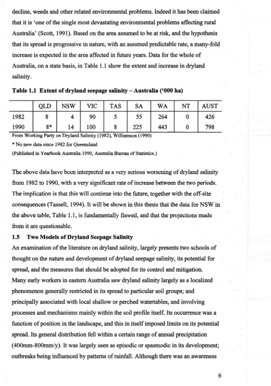
So much publicity has been given to dryland salinity and its potential for spread in
recent years that it has come to overshadow in the public mind most other land
decline, weeds and other related environmental problems. Indeed it has been claiined
that it is 'one of the single most devastating environmental problems affecting rural
Australia' (Scott, 1991). Based on the area assumed to be at risk, and the hypothesis
that its spread is progressive in nature, with an assumed predictable rate, a many~fold
increase is expected in the area affected in future years. Data for the whole of ·
Australia, on a state basis, in Table 1.1 show the extent and increase in dzyland
salinity.
Table 1.1 Extent of dryland seepage salinity - Australia ('000 ha)
QLD NSW VIC TAS SA
1982 8 4 90. 5 55
1990 8* 14 100 8 225
From Working Party on Dryland Salinity (1982), Williamson (1990)
*No new data since 1982 for Queensland
(Published in Yearbook Australia 1990, Australia Bureau of Statistics.)
WA NT
264 0
443 0
AUST
426
798
The above data have been interpreted as a very serious worsening of dryland salinity
from 1982 to 1990, with a very significant rate of increase b.etween the two periods.
The implication is that this will continue into the future, together with the off-site
consequences (Tassell, 1994). It will be shown in this thesis that the data for NSW in .
the above table, Table 1.1, is fundamentally flawed, and that the projections made .
from it are questionable.
1.5 Two Models of Dryland Seepage Salinity
An examination of the literature on dryland salinity, largely presents two schools of
thought on the nature and development of dryland seepage salinity, its potential for
spread, and the measures that should be adopted for its control and mitigation.
Many early workers in eastern Australia saw dryland salinity largely as a localized
phenomenon generally restricted in its spread to particular soil groups; and
principally associated with local shallow or perched watertables, and involving
processes and mechanisms mainly within the soil profile itself. Its occurrence was a
function of position in the landscape, and this in itself imposed limits on its potential
spread. Its general distribution fell within a certain range of annual precipitation
( 400mm-800mm/y). It was largely seen as episodic or spasmodic in its development;
outbreaks being influenced by patterns of rainfall. Although there was an awareness
[image:18.613.39.572.32.792.2]of the need for the restoration of a better hydrological balance in associated
catchments, the problem was seen as responsive to local measures; some of a
relatively short term nature. The need for wider community involvement was not
commonly acknowledged.
In contrast to the above much of the current opinion is that dryland salinity is·of
much wider regional dimension; mainly driven by steadily rising deep (regional)
. · . groundwater systems; resulting in progressive salinity development, predictable in its ·
spread, with the potential to affect much greater areas. The remedy is to reduce
recharge and lower groundwater levels on a regional scale. Measures proposed need
longer time scales than previously considered. Programs suggested also have much
greater implications for public policy and wider community involvement. More
recently, a more pessimistic view put forward is that little can be done to mitigate the
perceived potential problem within an acceptable time frame, and farmers must learn
to live with it (Walker, 1997).
Recharge of deep and shallow groundwater systems frequently occur simultaneously .
. Their combined effects may contribute to dryland salinity, and it may be difficult to
distinguish their separate effects.
1.6 Aims of this Thesis
The aims of this thesis are to review d.ryland seepage salinity in South-Eastern New
South Wales to determine which of the two alternative models describe the problem
and to suggest management strategies.
Some of the different aspects of the dryland salinity problem to be examined within
the thesis are:
i The history of salinity development.
11 The extent and magnitude of the problem.
iii The rate of dryland salinity expansion.
iv The nature of this expansion.
v The causes of dryland salinity.
VI The feasibility of achieving salinity abatement within an acceptable time
frame.
vii Measures and programs being proposed for salinity abatement in their
biophysical and socio-economic aspects.
ix The current situation in regard to the actual development of programs, and
their implementation; and
x Future Goals - Salinity and Sustainability.
The thesis begins with a review of relevant literature. This is followed by a general
assessment of the dryland salinity problem, and of the particular situation in the
South-East Region; as currently documented. Observations on selected case studies
across the region, covering the headwaters of all the principal catchments, are then
presented. Sites for study will be chiefly drawn from Wagner's (1986) study; plus
some additional sites to give a fuller coverage of the region. Collectively they cover
the main known outbreaks of dryland salinity in the region. Studies involved field
inspections, examination of sequential aerial photography covering each site, and
discussions with landholders and other workers associated with the problem.
Findings from these observ~tions, the associated land use and management, and other
factors related to the development and treatment of the problem up until the present
time are then examined. The development of salinity abatement programs, principally
in terms of the development of improved land use and management systems, are then
proposed. Finally, conclusions are drawn as to the magnitude and nature of the
2 DRYLAND SALINITY
2.1 Impact of Salinity on Plants
The most obvious effect of high salinity in the field is on plant growth. It may
prevent plant establishment, cause the death of plants, or significantly inhibit their
growth, and overall modify the plant environment. Different plants exhibit different
levels of salt tolerance. Some may be sensitive to certain levels of salinity at the
germination stage but may be quite salt tolerant once established. In other species the
reverse situation may apply. Some early workers suggested that plants could be
classified (Burvill, 1950), as 'salt tolerant' and 'salt escaping'. Whilst sonie plants
have true tolerance to high levels of salt, others establish and grow when salt levels
are low, and are dormant when it is high. Some deep rooting plants have the
capability to escape the effects of salting by drawing water from less saline lower
levels in the soil profile.
Plant growth may be affected, directly or indirectly, by salinity. Specific ions in the
soil water can be toxic to plant growth. Under extreme conditions, alkali salts,
corrosive to plant tissue may be formed, and are much more inhibiting to plant
growth than purely saline conditions. However, the principal inhibiting effect of
excess salinity on plant growth is through its effect on osmotic pressure. Increasing
salt concentrations in soil solutions increases their osmotic pressure, and results in a
greater total soil moisture stress which must be overcome by the plant to obtain its
water needs. Uptake of water may be restricted or entirely prevented by such a
process. The ability of plants to obtain water in saline conditions varies.
2.2 Soils and Salinity
Excess soluble salt, the main characteristic of salt-affected land, is associated with
the soil sodicity and alkalinity which may remain, even when the soluble salts have
been removed (WPDSA, 1982). Although there is no precise definition of a saline
soil for all situations, the criteria developed by Northcote and Skene for the Council
of the International Society of Soil Science covering Australia, Table 2.1, have been
widely adopted. These are based on a definition of salt-affected land as 'land which is
saline, or sodic or strongly alkaline anywhere within the top metre of the soil profile
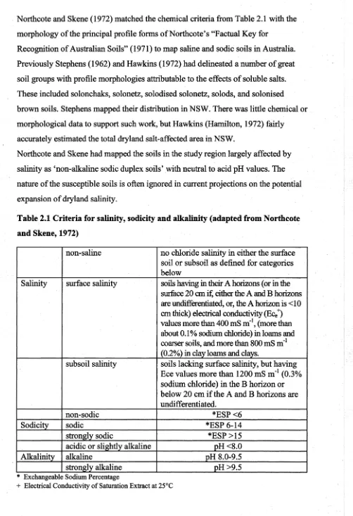
Northcote and Skene (1972) matched the chemical criteria from Table 2.1 with the
morphology of the principal profile forms ofNorthcote's "Factual Key for
Recognition of Australian Soils" (1971) to map saline and sodic soils in Australia.
Previously Stephens (1962) and Hawkins (1972) had delineated a number of great
soil groups with profile morphologies attributable to the effects of soluble salts.
These included solonchaks, solonetz, solodised solonetz, solods, and solonised
brown soils. Stephens mapped their distribution in NSW. There was little chemical or
morphological data to support such work, but Hawkins (Hamilton, 1972) fairly
accurately estimated the total dryland salt-affected area in NSW.
Northcote and Skene had mapped the soils in the study region largely affected by
salinity as 'non-alkaline sodic duplex soils' with neutral to acid pH values. The
nature of the susceptible soils is often ignored in current projections on the potential
expansion of dryland salinity.
Table 2.1 Criteria for salinity, sodicity and alkalinity (adapted from Northcote
and Skene, 1972)
non-saline no chloride salinity in either the surface soil or subsoil as defined for categories below
Salinity surface salinity soils having in their A horizons (or in the surface 20 cm if, either the A and B horizons are undifferentiated, or, the A horizon is <10 cm thick) electrical conductivity (Ee/) values more than 400 mS m·1, (more than about 0.1 % sodium chloride) in loams and coarser soils, and more than 800 mS m-1 (0.2%) in clay loams and clays.
subsoil salinity soils lacking surface salinity, but having Ece values more than 1200 mS m"1 (0.3%
sodium chloride) in the B horizon or below 20 cm if the A and B horizons are undifferentiated.
non-sodic *ESP <6
Sodicity sodic *ESP 6-14
strongly sodic *ESP >15
acidic or slightly alkaline pH <8.0
Alkalinity alkaline pH 8.0-9.5
strongly alkaline pH>9.5
*
Exchangeable Sodium Percentage [image:22.615.33.535.32.765.2]2.3 The Hydrologic Cycle
Outbreaks of dryland salinity are frequently considered in terms of changes to the
hydrologic cycle and the resultant mobilising and transport of salts in the landscape.
Generally, it is assumed that a state of hydrological equilibrium prevailed prior to
European settlement of Australia.
The generally accepted definition of groundwater is that component of water which
has percolated down to the saturated zone. The watertable represents the upper
surface of the saturated zone where the hydrostatic pressure is equal to atmospheric
pressure. A distinction is also made between (a) regional deep groundwater systems
contained in deep aquifers that underlie any number of surface catchments and (b)
discontinuous local or shallow groundwater systems held in perched aquifers which
generally more closely conform to the local landsurface.
Two principal processes, or mechanisms, may be distinguished in the downward
movement of water from the soil surface. The first is infiltration from the soil surface
into the soil mass by downward advance of the wetting front, followed by
. percolation from the soil mass down to the saturated zone. These two processes are
complementary. and some workers refer to the downward movement of water below
the root zone as 'deep percolation'. In dryland salinity the term seepage is often used
synonymously to cover both these terms as well as to cover upward movement by
capillary rise and shallow lateral movement.
The components of flow are often simply broken down into surface flow (Hortonian
flow), interflow and baseflow. Interflow as the intermediate sub-surface flow
component moves laterally downslope through the soil and coarse grained material
with some losses back to the surface as saturated overland flow or to below the
watertable as baseflow. Baseflow represents the proportion of precipitation that
ultimately moves down to the saturated groundwater system, and downslope in the
saturated zone.
Further subdivisions of sub-surface flow are frequently made with 'throughflow'
representing the upper flow component that moves laterally downslope through
certain soil horizons and is depleted en route by losses from evaporation and
evapotranspiration, saturated overland flow and downward percolation; and interflow
being defined as the lower flow component which similarly moves laterally
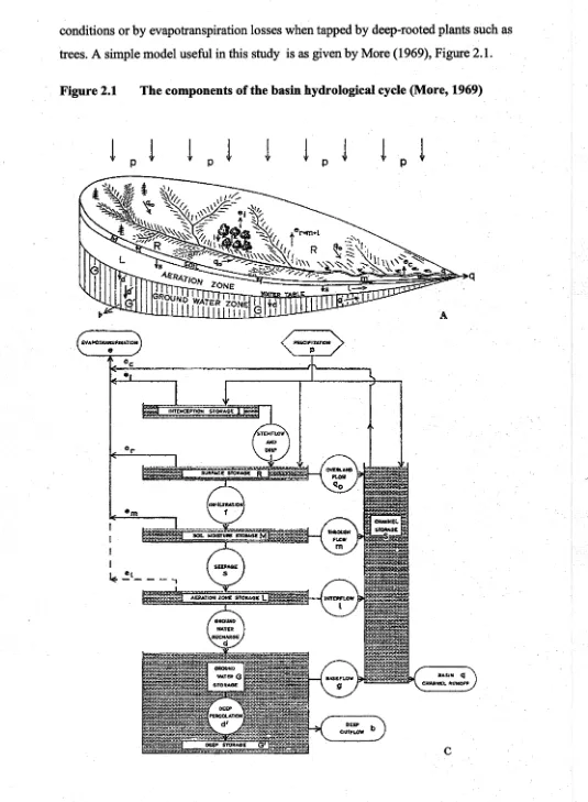
conditions or by evapotranspiration losses when tapped by deep-rooted plants such as
[image:24.615.8.543.32.761.2]trees. A simple model useful in this study is as given by More (1969), Figure 2.1.
Figure 2.1 The components of the basin hydrological cycle (More, 1969)
!
I I I
p
l
LE- ~l- - - ,
!
p!
p!
pImportance has been placed on different components of flow as the causal
mechanisms in the development of dryland salinity. In Western Australia there has
been controversy between the importance of rising deep groundwater tables and
'throughflow' (Conacher, 1975)(Whittington, 1975). In recent studies in NSW, there
has been a greater emphasis on the rising deep groundwater table hypothesis,
neglecting studies of the pedological, geomorphic and climatological attributes and
the other processes involved in association with the prevailing land use and
management. As a result, whilst there has been a great deal of work on groundwater ·
. monitoring, no dynamic interpretation of the develo~ment of the problem has
emerged. The most repeated message is that regional (deep) watertables, or
groundwater pressures are rising, and this will cause massive expansion in the ar~a of
dryland salinity.
2.4 Dryland Salinity in Australia.
An overview of salinity in Australia is given by Ghass~ et al (1995) and State of ·
the Environment Australia (1996). Here we consider salinity development in
individual States.
2.4.1 Western Australia
References to dryland salinity in Western Australia occur as early as 1897. However,
it was not recognised as a potential significant land degradation problem until
sometime later (Wood, 1924). Western Australia has built up an extensive literature
on the subject. The later recognition of dryland salinity in other States has meant that
this work has been widely drawn upon, and has very much influenced thinking as to
· the nature of the problem.
Prior to World War II, Teakle and Burvill (1938) carried out investigations into
salinisation, because of the mounting concern. By this time many farms in the wetter
parts of the wheat belt near to salt lakes had been abandoned to wheat growing. They
noted rising groundwater levels and associated this with land clearing for wheat
growing, and recorded that the predominant salt was sodium chloride. Teakle (1938),
in a separate study, viewed the problem as an ephemeral one representing a stage in
the development ofland for crop production. Ultimately the excess salts that had
built up in the soil would be leached out and a balance at levels not toxic to crop
production would be established. In terms of land development, he in effect,
A subsequent paper on the Post War Period by Burvill (1947) supported the
hypothesis of rising watertables, following extensive clearing, as the cause of the
spread of dryland salinity. Millington et al. (1951) attributed seepage to three
different mechanisms. These were:
• Summer moist areas. Springs and seepages commonly developed some years
after clearing on the sides of gullies and hillside slopes in the 400-750mm
rainfall areas. Excess subsoil moisture accumulated from the winter intake of
rain was brought to the surface by impervious subsoil layers and the soils
remain wet throughout the year. Evaporation at the surface concentrated salts
and bare sterile patches resulted. A few centimetres below the surface the salt concentration in the soil might be quite low.
• Salting due to valley waterlogging. Related to the above but larger areas
affected where the topography was flatter in the outer wheat belt. Broad flat
valleys were affected by rising watertables. This followed agricultural
development, and wet winters like 1945 and 1946 accentuated the problem.
Salt water, about the concentration of sea water, originally occurred at depths
of 5-1 Om in many places but now was found in borings within 2m of the
surface. From such shallow depths the water readily reaches the surface by
capillary rise and evaporates, leaving the salt in the surface soil.
• Salt patches without shallow water tables. Bare salt patches develop after
clearing on some of the heavier soils and the powdery 'morrel' soils of the
outer wheat growing areas with 280-360mm annual rainfall. These soils occur
on the flats or gentle slopes of the valleys of the salt lake systems, but it was
also common to find salt patches on similar soils in the higher parts of the
landscape. These soils contain quite large amounts of salt before clearing, and
although the groundwater level, if any, is Sm or more from the surface, yet
redistribution of salt occurs in the upper layers; and bare patches, often caked
and hard, develop due to salt concentrations.
In the subsequent years, there was considerable controversy as to the role of flow mechanisms and salt sources in the development of the widespread salinity that was
occurring. Boughton (1970), and Holmes (1971), supported the rising deep
clearing of trees, and the replacement of deep-rooting perennial plant communities
. with annual crops and pasture with comparatively shallow root systems. Under a
Mediterranean-type climate this resulted in a decrease in the amount of water lost
from the soil by evapotranspiration and an increase in the amount of water recharging
of groundwater systems. Consequently a rise in groundwater levels to at least within
the capillary fringe of the soil surface occurred. Concentration of salt by evaporation
of soil water at the surface increased the salinity to levels that could not be tolerated
by most crops and pasture plants. The Department of Agriculture, WA, concluded
that it was not possible to reverse or remedy the situation directly, and the the most
effective form of amelioration was to revegetate the affected areas with salt-tolerant
plants.
The controversy was heightened with the publication by a farmer, H.S. Whittington
· (1975) of his account of how he had regenerated farming land seriously degraded by
salt encroachment on his property 'Springhill', Brookton, WA, by using a system of
'interceptor banks'. From monitoring water flow on his own property he concluded
that the cause of dryland salinity was throughflow, the lateral downward movement
of water within the soil above a plough sole or hardpan which had developed as a
result of farming practices, since the property was first settled and cleared.
Whittington believed salinisation was in no way associated with a deeper rising
groundwater table. His system of interceptor banks was designed to intercept the
throughflow moving downslope and remove the impervious hardpan and allow the
water to percolate through the deeper subsoil layers to the deeper groundwater system
where it would no longer contribute to throughflow.
Conacher (1975) tested the 'throughflow' model of Whittington, for several
locations in the WA wheat belt. He concluded that soluble salts move from the
catchments to the valley bottoms by a combination of: (1) occasional overland flow;
(2) throughflow, and (3) streamflow down minor tributaries. The water supplied to
the valley bottoms is prevented from percolating to deeper levels by a thick
impermeable hardpan. This hardpan is the upper confining layer of the deeper aquifer
system in which the groundwater is under pressure. Surface or near-surface
waterlogging of the valley bottoms is essentially a shallow perched water table
phenomenon. Evaporation during summer concentrates the salts in the valley bottom
increased extent and duration of saturation of scalded soils, since clearing, appear to
be derived primarily from an increase in throughflow and less from overland flow.
In an earlier paper, Conacher and Murray (1973) stated that salt scalds must be
related to landsurface characteristics and that there was no evidence to support the
'prevalent view that rising groundwater tables had caused salt scalding. They
concluded, that in the area of study, there was no conclusive evidence of widespread
rise in the groundwater table. Conacher (1975) noted the observation of Whittington
that over a 12 month period, up to 56% of precipitation had been distributed as
throughflow and only 9% by overland flow on valley side slopes. From his studies
Conacher ( 197 5) concluded that measured salinity concentrations of throughflow
waters increasing downslope to the valley bottoms were clearly sufficient to explain
the build up of salinity in salt scalds to toxic proportions. He did accept, however,
that where piezometric heads of groundwater are above the ground surface, it is quite
possible that the water may gradually diffuse through the hardpan and thus contribute
to salt scalding.
The hypothesis of throughflow as a principal mechanism in the development of
dryland salinity and interceptor banks as the means of control was accepted by a large
and influential group of farmers in the wheat belt. However the Department of
Agriculture, WA, concluded that the development of dryland salinity was caused by
rising groundwater tables following widespread clearing for agricultural
development, and as rising watertables could not be treated, since it would not be
feasible to return large areas back to natural vegetation, farmers would have to live
with the problem. Research was conducted into the use of salt-tolerant plants and
associated agronomic management practices, and this approach has largely continued
until the present time .. It is somewhat ironic that whilst the extension of salinisation
was being observed across the wheatbelt, in the middle and late 1960s, a :further one
million acres (400000 ha) were being cleared of natural vegetation each year for the
expansion of agricultural production; as a consequence of government policy.
Conflicting points of view became so strong in the late 1970s, that in July 1977 a
Public Works Department investigation was set up to examine the Whittington
interceptor system. A separate report was also requested from Professor J.W. Holmes
as an 'independent' consultant. The prime objective of the first investigation was to
effects) whilst Professor Holmes' brief was to advise on its potential to control land
and stream salinity. Both reports concluded that the main source of stream salinity
was from deep groundwater or deep seepages. Holmes (1979) went on to state that
the only answers to the problems were: (a) to install deep drains and to dispose
safely of the saline drainage water; or (b) to re-establish a woodland community upon
strategic landscape locations so as to return the valley and slope hydrology to its
pristine condition. The choice would probably depend upon whether reclamation of
salt-affected land, or the protection of the quality of stream water was the
predominant need. Holmes concluded that the transportation or translocation of salts
through 'very poorly permeable strata' in sufficient quantity by the process of
'throughtlow' was not feasible from a number of aspects.
In spite of the above reports, farmers, principally through the WI SAL TS group,
continued to install interceptor bank systems, claiming some measure of success;
whilst Conacher et al (Part. I, 1983) not very convincingly defended their use in the
dewatering of perched soil-water systems, admitting they were only partly successful.
Failures were blamed on either incorrect design and construction, or on unfavourable
soil properties. They concluded that whilst throughtlow may provide the dominant
input of water to salt-affected land, increased groundwater discharges may provide
the main mechanism for the mobilisation of in-situ salts beneath salt scalds. It was therefore desirable to implement measures to control both mechanisms. The ideal
method to do this was likely to involve farm management strategies on saltland
catchments, employing commercially useful vegetation which simulates the
hydrological role of the native species, in conjunction with the improvement in
throughtlow control systems.
Negus (1987) showed, after fourteen years of monitoring, that there was no evidence
that seepage interceptor drains and banks had reduced the topsoil salinity on 10 of the
11 sites in three shires within the wheat belt of WA. In fact, topsoil salinity had significantly increased at four of these sites, one site had shown a significant decrease
and the remaining six showed no significant change. Other papers by McFarlane et
al. (1990) generally supported these findings. Current research and investigation
programs and extension programs in WA are principally based on the premise that
the most productive use ofland marginally affected by salinity. There are three
principal avenues of work:
• Biological revegetation programs. Much of this is summarised by George et al. (1993) and includes everything from various tree planting strategies in
both high and low rainfall areas, perennial and annual pasture mixtures,
combinations of mixed stands of shrubs (principally saltbushes), to sown
species of perennial grasses and legumes plus other low value volunteer
herbaceous species (normally considered weed species). Much of this latter
work using various species of saltbushes in combination with dry weed
species is very interesting in terms of the more productive use being made of
the marginally affected areas (Warren and Casson, 1992). These programs
have dual objectives: (a) to make more productive use of the land, and (b)
have some positive effect on watertable levels.
• Engineering options. Principally these involve drainage systems. George and
McFarlane (1993) cover most of the options for drainage, from the relatively
low cost bank systems to the very high cost deep drainage and pumping
systems. In drainage systems generally, there has to be some lower point for
drainage discharge. The soils also have to be sufficiently permeable to permit
effective drainage. Finally the overall costs must be less than the value of the
asset being protected. Such systems may be used singly or in conjunction with
revegetation systems, but cost is a significant factor.
• Hydrogeological and geophysical studies. A wide range of groundwater
hydrology and water balance studies have been undertaken. Hydrogeological
studies by Lewis (1992) in the Northam area (WA) involved the development
of predictive mQdels. of groundwater recharge, discharge and salinisation.
Such studies should give a better understanding of groundwater systems and water
balance characteristics, and suggest the land use and management options that may
be applied, and the magnitude of the changes that must be made. However, they have
their limits in broad application across different landscapes and climates, and
although they may represent a more rational approach to salinity prevention and
control, it appears that treatments will largely remain symptomatic .
A summary of the important findings from the literature review of research in
Western Australia include:
• Cyclic salt accessions. With the prevailing weather systems on shore and
from the west, measurements indicate that atmospheric deposition is a
significant source of salt contained in soil profiles to a more marked extent
than in south eastern Australia. This effect drops off with increasing distance
inland. Moreover there has been greater opportunity for salts to accumulate in
the pallid zones of the ancient laterite landscapes. Secondary salinisation as is
now widely occurring is a consequence of the redistribution of these salts. ·
• Landscape. Extensive areas oflaterite sandplains and salt lakes of low relief
with little opportunity for external drainage are unique to the southwest of
Western. Australia where dryland salinity principally occurs. These are largely
underlain by a pallid zone which has provided a salt store over long periods of
time. This contrasts with the areas of higher relief and more fragmented
landscapes in south eastern Australia, where there are less opportunities for
salt store.
• Clearing and salinity. The removal of native vegetation, principally in the
form of woody perennials and trees, and their replacement largely with annual
crops and pastures has changed the hydrological balance and increased
accessions to groundwater. Also the denudation of ground surfaces, and the
removal of the protection provided by shaded conditions has significantly
increased the potential for soil evaporation to occur, resulting in increased salt
concentrations in surface horizons and at the soil surface itself. Despite the
fact that the relationship between land clearing and salinity development had
been quite well established, clearing of land for agricultural production
continued at a rapid rate.
Studies by Conacher (1983) showed a 'lag' time of20-30 years between
catchment clearing and the first appearance of salt, though significantly
shorter periods of 5-7 years or longer, up to 40 years, could occur. In eastern.
Australia, particularly in the grazing areas of south-eastern. NSW, it is thought
that the 'lag' time could be considerably longer than this in some cases,
• Extent and magnitude of the problem. As shown in Table 1.1 the area
affected by salinity is much greater in Western Australia than in any other
State; as is the potential for increase. The financial impacts on the Western
Australian farmers have been much greater than elsewhere. Whilst the overall
financial viability of the individual farm could be put at risk in WA, such a
situation appears to rarely apply in NSW.
• Off-site effects. The first evidence of salinisation in south western WA was
through its effects on water quality, and the first measures proposed were
revegetation of previously cleared catchments to remedy this problem. Some
suggest (Conacher et al. 1983) that increasing stream salinity may well be a
more serious problem than that of soil salinisation. There appears to be little
current comment on its adverse effects on other aspects of the built-up
environment despite concerns about the effects of salinity on such aspects ·
(Watson et al. 1995).
Treatment of the problem. Much of the current effort in WA is directed towards
making more productive use ofland marginally affected by salinity, and considerable
progress has been made in saline land agronomy research. This means in effect,
however, more emphasis has been placed on discharge sites themselves, rather than
treating recharge sites, that are generally considered as the source of the problem.
Although much useful work is being done, the situation is still very much as
Conacher (1975) stated, that the 'prevalent belief is that the cause of the problem
cannot be treated but farmers must learn to live with it and adapt land use and
management practices accordingly'. This thinking has spilled over into the National
Salinity Control Program where Robertson (1995) stated that 'the goal of the
National Dryland Salinity Program is to generate integrated techniques and
approaches for optimal management of dryland salinity in Australia'. In answer to a
question following presentation of his paper, he stated that 'the future would be about
managing salinity, curing it was an impossible task'. Whether a distinction can
readily be drawn between 'managing a problem' or 'curing a problem', integrated
programs involving both 'discharge' areas and 'recharge' areas are being accepted as
2.4.2 Victoria.
The original assessment by the Working Party on Dryland Salting (1982) showed a
much larger area affected in Victoria, 90000 ha, than in NSW, 4000 ha. However, ·
about half of the area shown as seepage salinity in Victoria was described as Type
4.2, Subsoil Saline Seepage, or 'incipient salting'. That is soil with a saline subsoil
only, and a watertable below the capillary range, the only observable surface
indications of salinity are the growth ofhalophytic plants. Later estimates (Crabb,
1997) suggest a much greater potential for spread in NSW than in Victoria. ·
In 1855, only 19 years after settlement, John G. Robertson, a grazier near Coleraine,
Victoria, wrote to Governor La Trobe drawing attention to the development of salt
springs and other associated forms of land degradation following clearing and
stocking. However, as elsewhere in south eastern Australia, up until the 1950s it was
not regarded as a significant problem (Holmes, Leeper and Nicolls, 1939, Downes,
1949), At first it appeared to be 'a minor or transitory problem' and of 'academic
interest only'.
A comprehensive study by Cope (1958) however, indicated that the problem was
widespread and increasing. He also put forward an hypothesis for the genesis of the
problem, and suggested measures for its control and mitigation. Although catchment
management was seen as important to the mitigation of the problem, Cope saw the
soils of salted areas as possessing distinctive characteristics, with the problem mainly
associated with solodic or solonetzic soils, with marked profile differentiation and
low permeability at depth. He emphasised the importance of soil morphology for
saline seeps in central Victoria. In that area, the affected soils have a permeable 'A'
horizon with marked profile differentiation to a clay 'B' horizon, which is often sodic
and impermeable at depth. The main incidence of dryland seepage salinity was on
areas of rolling to hilly topography in 500-750 mm rainfall areas on these soils. In
higher rainfall regions, drainage systems tend to develop, and these prevent the
accumulation of soluble salts in the soil.
Cope also showed that dryland salinity did not develop in areas characterised by
permeable soils and strata with improved leaching and drainage. He also pointed to
the restricted nature of the actual occurrence of salinity and concluded that 'problems
seem to arise only when there exists a combination of ecological factors (an
concentration of the salt in smaller localised areas'. His mapping of salting showed
virtually no agreement between the distribution of salinity and the occurrence of
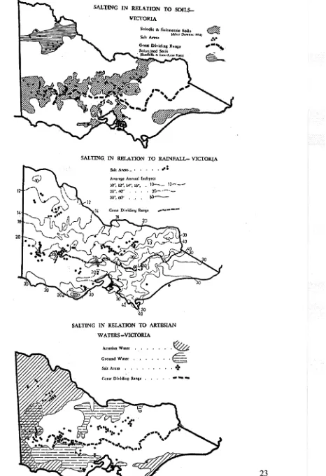
groundwater, but a high correlation with soil morphology and rainfall parameters
(Fig. 2.2). He believed the main problem was the erosion hazard which salting
induces.
Cope also noted that, generally, areas of salting tended to spread spasmodically rather
than gradually, the spread being correlated with wet years. His interpretation of how
salinity actually occurs had much in common with Whittington's (1975) and
Conacher's (1975) concept of 'through.fl.ow' in Western Australia, with water
moving laterally downslope on top of the impermeable 'B' horizon, carrying with it
any soluble salts present in the topsoil and salts being accumulated at lower levels in
the landscape, where sub-surface drainage was impeded, or where salts were
concentrated further by evaporation.
Subsequent to Cope's study, Downes (1960) stated:
"Early recognition of the problem enables rapid reclamation merely by
improving water use in the catchment and fencing out of incipient salt
areas to prevent overgrazing by stock. In advanced stages however,
reclamation is beset with all the problems normally associated with
soils of high salinity".
From the early 1980s much more emphasis was given to the role of deep
groundwater and rising watertables as the underlying cause of salinity, and attention
became focused on the development of strategies to reduce recharge and subsequent
accessions to groundwater systems. Jenkin and Morris (1982) interpreted land
management in catchments in terms of: 'permanent' or perennial recharge areas that
should be planted to trees to maximise interception of rainfall and transpiration of
soil water. Other cleared upland areas should be planted to trees and deep-rooted
perennial pastures. In lower arable areas, improved cropping and management systems involving chan~es in rotations, length of fallow and other associated
cropping practices, pasture maintenance and the use of deep-rooted perennial species,
together with tree plantfu.g~ needed to be developed. In the latter two situations the
aim was to plant as many trees as possible without reducing agricultural productivity,
Figure 2.2 Salting in Victoria (Cope, 1958)
20
SALTING IN RELATION TO SOII.S-VIC'fORIA
Solodi<: 6< SOlonotaie Soll•
S..lt Arca.. lAFcu .Dowau 19S4J
SALTING. IN RELATION TO RAINFALL-VICTOR.LA
.
Sah Arca•-• • • • • rl'•A. venge Annual lsohy.,•
10'', 12", 14'', 16", 10---
12---20", 40" • 2{) · ·
-30'', 611' • .• • 6 0
-
---SALTING IN RELATION TO ARTESIAN W ATERS-VICIORIA
ArteSian Water • .
Ground Water
.~
_,c:..
~
S.lt Areas , • • • . • • • •
+
-Dumsday et al. (1985) studied the economic aspects of dryland fanning systems, relative to their effect on the deep percolation of water to groundwater systems. The
authors accepted that the primary cause of dryland salinity is increased groundwater
recharge. Other things being equal, the higher the recharge, the higher the external
costs.are likely to be, principally in terms of dryland soil salting and stream water
quality. Dumsday et al. (1985) developed a model, the Modified SOLLCV Model, a
daily water balance simulation model, designed to quantify relationships between
fanning systems and accessions to groundwater under different environmental
conditions. It was concluded that 'the results of the fanning systems approach
indicate that there is scope for significantly alleviating the problem of dryland salinity
in both cropping and grazing regions through relatively minor changes to existing
farming systems'. However, they pointed out the limitations of such a restricted
modelling approach. This was 'that the approach was based on the assumption that
controlling deep percolation will ultimately lead to a reduction in salinity. Until the
. relationship between deep percolation and the incidence (in terms of extent and
location) of salinity can be quantified, this is as far as any generalised approach may
be taken'.
Similar methodology has been adopted with modifications by others to examine the
impact of farming systems and management practices on the development of dryland .
salinity and the associated social and economic consequences. McGuinness et al.
(1993) examined the impact of conservation cropping systems on groundwater
recharge.
Based on recent projections, the dryland salinity problem in Victoria is seen as
having the potential to greatly expand, with an estimated 1 million ha at risk of
salinisation. Such projections do not agree with Cope's (and others) original
assessment of the problem. Much of the findings from field studies such as those
made by Cope (1958) appear to be disregarded. The claim is made that a modelling
approach is a much quicker and less expensive method of providing answers than
field studies.
Another avenue of research in Victoria is the use of trees for groundwater recharge
control. Such methods as sap flow measurements and ventilated chambers have been
used by Clifton ( 1992) to measure tree water use. From these, models have been
recharge control under different land systems. This work has proceeded in
conjunction with studies into the effectiveness of perennial grass pastures in reducing
or preventing recharge. The work indicates that under Victorian conditions, whilst
high density tree planting is an effective salinity control measure for high recharge,
higher rainfall, hill country; well-managed perennial pastures are effective in
preventing recharge in sedimentary hill country with up to 600 mm annual rainfall.
Combinations oflow density tree planting and pasture, in agroforest and woodland
form, are also being examined.
Results from Victoria have been incorporated in regional dryland salinity
management plans, based on identifiable land management units within such regions,
with appropriate strategies and cost sharing arrangements developed for each. An
example of this is the Goulburn-Broken Region, Dryland Salinity Plan (1989).
Whether the above approach is the best approach to salinity abatement overall has
been questioned in a number of socio-economic studies in Victoria (Kent, 1993).
Recently, Dahlhaus et al. (2000) have used historial evidence and pedological studies
to develop a model for the salinity processes on the Dundas tablelands in
south-eastern Victoria. They conclude that salinity in the area was a feature of the
pre-European landscape, and that there is no evidence of rising groundwater levels. Their
model, with seasonal waterlogging and lateral flow of water in the upper regolith, can
better account for the occlirrence of salinity than the rising groundwater hypothesis.
This supports Cope's earlier studies. In associated historical studies, Nathan (1999,
2000) questioned the validity of applying the groundwater recharge model to other
parts of Australia without corresponding historical research. Interestingly, she also
challenged the earlier references made to Robertson's (1855) observations regarding
clearing and salt spring development. She found that no association between salting
and tree loss was remarked upon in Robertson's original documents; rather he made
2.4.3 New South Wales
2.4.3.1. Land degradation within NSW
The area currently affected by dryland salinity in NSW is of a limited extent. Data
from the Land Degradation Survey, NSW, 1987-88, Soil Conservation Service of
NSW in Table 2.2, show the comparative extent of the various forms ofland
degradation.
Table 2.2 Land degradation* NSW 1987-88. Soil Conservation Service of
New South Wales (1988)
Type Area affected
Eastern and central Western divisions Whole State divisions
% km2 % km2 % km2
Sheet and Rill 20.3 100060 0.3 700 12.5 100760
Erosion
Gully Erosion 32.0 158250 9.2 23940 23.4 186290
Mass 4.7 n/a 0.0 n/a 2.9 n/a
Movement
Wind Erosion 25.3 125070 24.6 75380 24.5 200450
Induced Soil 17.1 84200
-
-
10.6 84200Acidity
Soil Structure 28.9 142880 1.4 4070 18.3 146950
Decline
Woody Shrub 4.6 22770 66.8 204950 28.4 227720
Scalding 5.1 25310 18.6 57080 10.3 82390
Irrigation 1.3 n/a 0.0 0.9 n/a
Salinity
Dry land 2.1 n/a <0.1 n/a 1.3 n/a
Salinity
*: In addition to the above there is the general problem of nutrient depletion or soil fertility decline
which is just as, or more, serious a land degradation problem than any of those tabled above. Its impact
on the other forms of land degradation can be of major consequence and its correction of major
importance in land rehabilitation.
A check of the methodology (Graham, 1988) used in the survey in Table 2.2 revealed
that it is in part a land degradation hazard assessment, (a prediction of the level of