New Magnetic Anomaly Map of the Antarctic
A. V. Golynsky1 , F. Ferraccioli2 , J. K. Hong3 , D. A. Golynsky1 , R. R. B. von Frese4, D. A. Young5 , D. D. Blankenship5 , J. W. Holt5, S. V. Ivanov6, A. V. Kiselev6 , V. N. Masolov6, G. Eagles7 , K. Gohl7 , W. Jokat7 , D. Damaske8, C. Finn9 , A. Aitken10 , R. E. Bell11 , E. Armadillo12 , T. A. Jordan2 , J. S. Greenbaum5 , E. Bozzo12, G. Caneva12, R. Forsberg13 , M. Ghidella14, J. Galindo-Zaldivar15 , F. Bohoyo16 , Y. M. Martos17 , Y. Nogi18 ,
E. Quartini5,19 , H. R. Kim20 , and J. L. Roberts21,22
1
VNIIOkeangeologia, All-Russian Scientific Research Institute for Geology and Mineral Resources of the World Ocean, St. Petersburg, Russia,2British Antarctic Survey, Cambridge, UK,3Korea Polar Research Institute, Yeonsoo-gu, South Korea, 4
School of Earth Sciences, Ohio State University, Columbus, OH, USA,5Institute for Geophysics, Jackson School of Geosciences, University of Texas at Austin, Austin, TX, USA,6Polar Marine Geosurvey Expedition, Lomonosov, Russia, 7
Alfred-Wegener-Institut Helmholtz-Zentrum für Polar und Meeresforschung, Bremerhaven, Germany,8Bundesanstalt für Geowissenschaften und Rohstoffe, Hannover, Germany,9United States Geological Survey, Denver Federal Center, Denver, CO, USA,10Centre for Exploration Targeting, University of Western Australia, Perth, Western Australia, Australia,11Lamont Doherty Earth Observatory, Columbia University, Palisades, NY, USA,12DISTAV, Università di Genova, Genoa, Italy, 13
National Space Institute, Technical University of Denmark, Copenhagen, Denmark,14Instituto Antártico Argentino, Buenos Aires, Argentina,15Instituto Andaluz de Ciencias de la Tierra, CSIC-Universidad de Granada, Granada, Spain, 16
Instituto Geologico y Minero de España, Madrid, Spain,17Goddard Space Flight Center, NASA, College Park, MD, USA, 18National Institute of Polar Research, Tokyo, Japan,19Department of Geological Sciences, Jackson School of Geosciences,
University of Texas at Austin, Austin, TX, USA,20Department of Geo-Environmental Sciences, Kongju National University, Kongju, South Korea,21Department of the Environment, Australian Antarctic Division, Kingston, Tasmania, Australia, 22
Antarctic Climate and Ecosystems Cooperative Research Centre, University of Tasmania, Hobart, Tasmania, Australia
Abstract
The second generation Antarctic magnetic anomaly compilation for the region south of 60°S includes some 3.5 million line-km of aeromagnetic and marine magnetic data that more than doubles the initial map’s near-surface database. For the new compilation, the magnetic data sets were corrected for the International Geomagnetic Reference Field, diurnal effects, and high-frequency errors and leveled, gridded, and stitched together. The new magnetic data further constrain the crustal architecture and geological evolution of the Antarctic Peninsula and the West Antarctic Rift System in West Antarctica, as well as Dronning Maud Land, the Gamburtsev Subglacial Mountains, the Prince Charles Mountains, Princess Elizabeth Land, and Wilkes Land in East Antarctica and the circumjacent oceanic margins. Overall, the magnetic anomaly compilation helps unify disparate regional geologic and geophysical studies by providing new constraints on major tectonic and magmatic processes that affected the Antarctic from Precambrian to Cenozoic times.Plain Language Summary
Given the ubiquitous polar cover of snow, ice, and seawater, the magnetic anomaly compilation offers important constraints on the global tectonic processes and crustal properties of the Antarctic. It also links widely separated areas of outcrop to help unify disparate geologic studies and provides insights on the lithospheric transition between Antarctica and adjacent oceans, as well as the geodynamic evolution of the Antarctic lithosphere in the assembly and breakup of the Gondwana, Rodinia, and Columbia supercontinents and key piercing points for reconstructing linkages between the protocontinents. The magnetic data together with ice-probing radar and gravity information greatly facilitate understanding the evolution of fundamental large-scale geological processes such as continental rifting, intraplate mountain building, subduction and terrane accretion processes, and intraplate basin formation.1. Introduction
The extensive cover of snow, ice, and seawater makes magnetic surveying very effective for obtaining insights into the crustal geology of the Antarctic. Multinational efforts since the 1957–1958 International Geophysical Year have collected a considerable amount of magnetic data, despite the formidable logistical challenges of surveying in the Antarctic. The recognition that a continental-scale compilation of regional magnetic surveys further enhances their geological utility spawned supporting resolutions from the Scientific Committee on Antarctic Research (SCAR) and the International Association of Geomagnetism and
RESEARCH LETTER
10.1029/2018GL078153
Key Points:
• We present a new 1.5-km grid of Antarctic near surface magnetic anomalies
• The compilation contains more than 3.5 million line-km of airborne and shipborne data
• The magnetic anomaly compilation is a new tool to investigate the Antarctic lithosphere and subglacial geology
Correspondence to: A. V. Golynsky and J. K. Hong, sasha@vniio.nw.ru; jkhong@kopri.re.kr
Citation:
Golynsky, A. V., Ferraccioli, F., Hong, J. K., Golynsky, D. A., von Frese, R. R. B., Young, D. A., et al. (2018). New magnetic anomaly map of the Antarctic.
Geophysical Research Letters,45, 6437–6449. https://doi.org/10.1029/ 2018GL078153
Received 30 MAR 2018 Accepted 1 JUN 2018
Accepted article online 8 JUN 2018 Published online 6 JUL 2018
©2018. The Authors.
Aeronomy (Johnson et al., 1997). Accordingly, thefirst Antarctic magnetic anomaly compilation (ADMAP-1) was produced in 2001 from more than 1.5 million line-km of shipborne and airborne measurements and 5.6 million line-km of satellite magnetic observations from the Magsat mission (Golynsky et al., 2001; Golynsky, Chiappini, et al., 2006; von Frese et al., 2002).
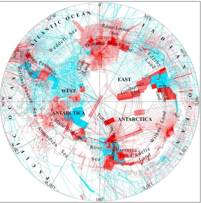
The ADMAP-1 compilation merged the near-surface magnetic survey data collected between the International Geophysical Year and 1999 (Figure 1). It provided new insights into the structure and evolution of Antarctica, including some of its Proterozoic-Archean cratons and Proterozoic-Paleozoic orogens, Paleozoic-Cenozoic magmatic arcs, continental rift systems, and rifted margins, as well as large igneous pro-vinces and the surrounding oceanic gateways (e.g., Ferraccioli & Bozzo, 1999; Ferraccioli, Bozzo, & Capponi, 2002; Ferraccioli, Bozzo, & Damaske, 2002; Finn et al., 1999; Golynsky et al., 2000; Golynsky, Masolov, et al., 2006). These data were also released to the World Data Centers in 2008 and incorporated into thefirst World Digital Magnetic Anomaly Map (Maus et al., 2009).
[image:2.612.178.573.89.489.2]obtained within the scope of the International Polar Year 2007–2008 in multidisciplinary projects that also acquired airborne laser altimetry, radio echo sounding, and gravity anomaly data for comprehensive studies of the surface, thickness, and internal features of the ice sheets and the subglacial geology and hydrology. The new surveys targeted coverage gaps in ADMAP-1 such as over the Gamburtsev Subglacial Mountains (Ferraccioli et al., 2011), Dronning Maud Land (e.g., Ferraccioli, Jones, Curtis, Leat, & Riley, 2005; Ferraccioli, Jones, Curtis, & Leat, 2005; Mieth & Jokat, 2014; Shepherd et al., 2006), Wilkes Land (e.g., Aitken et al., 2014; von Frese et al., 2009, 2012), the Wilkes Subglacial Basin and the Transantarctic Mountains (e.g., Ferraccioli, Armadillo, Jordan, et al., 2009; Studinger et al., 2003, 2004, 2006), and other regions (e.g., Damaske et al., 2003; Damaske & McLean, 2005; Ferraccioli et al., 2006; Golynsky, Masolov, et al., 2006; Golynsky, Golynsky, et al., 2006; Jokat et al., 2003; Leinweber & Jokat, 2012; Stagg et al., 2004). The compilation procedures and resultant ADMAP-2 magnetic anomaly grid are presented in the next sections, followed by selected examples of the compilation’s utility for geological studies of the most poorly understood crust on Earth.
2. Compilation Procedures
The new magnetic anomaly data could not be easily combined with the ADMAP-1 data, and therefore, all survey lines were processed into regional grids that were subsequently merged into thefinal Antarctic compilation. All survey lines were visually inspected to identify and mitigate the effects of data gaps, spikes, tip-tank errors, residual diurnal variations (e.g., Damaske, 1989; Saltus & Kucks, 1992), and incomplete or incorrect magnetic compensation noise from the airborne electromechanical systems. Residual high-frequency noise along the survey lines was further suppressed using low-pass Butterworthfilters. All survey lines were then leveled, and in several cases also microleveled (e.g., Ferraccioli et al., 1998) within regional clusters (Figure 1) covering (1) the Antarctic Peninsula and adjacent marine regions, (2) Dronning Maud Land, (3) Enderby Land, (4) the Prince Charles-Gamburtsev Mountains, (5) Wilkes Land, (6) Victoria Land, (7) the Amundsen Sea Embayment-Marie Byrd Land, (8) the Indian Ocean, (9) the Atlantic-Pacific Oceans, and (10) interior East and West Antarctica.
All profiles within overlapping survey areas were used to recover as much magnetic anomaly detail as pos-sible. Initially, these profiles defined possible level misfits or systematic biases between adjoining surveys. Variance analysis was used to define the required profile adjustments. Regional data sets were adjusted to essentially zero dispersions. All determined corrections were applied as necessary and subsequent cross-over analysis of the adjusted profiles leveled them with the overlapping surveys. As a rule, the corrections were applied predominantly to the older, poorer quality survey profiles.
The 10 regional grids were stitched together with the more detailed grids based on targeted aeromagnetic surveys withflight-line intervals varying from 0.5 to 5 km. Geosoft, Inc.’s suturing tool, GridKnit™(Oasis mon-taj, 2014) was applied to merge the detailed and reconnaissance grids. Fast Fourier transforms of the grid dif-ferences yielded differential wave number by wave number corrections that smoothly joined the grid edges. The more irregular networks of regional profiles were initially merged to provide a framework into which the new and more strongly weighted detailed anomaly grids could befitted. Before stitching, each individual grid was masked to exclude extrapolated values along the boundaries. All gridding was performed by the minimum curvature technique (Briggs, 1974).
The aeromagnetic and marine grids were merged into a grid at an interval of 1.5 km and low-passfiltered for wavelengths roughly≥7 km to produce thefinal compilation in Figure 3. To honor the anomaly resolution of the original data sets as fully as possible, the terrestrial survey grids were not continued to a common elevation. However, along the Antarctic Peninsula margins, downward continuing the aeromagnetic profiles collected by the ICEGRAV, USAC, and Magnet projects (Forsberg et al., 2018; LaBrecque et al., 1986; Hittelman et al., 1996) from altitudes varying over 5,000 to 10,000 m above sea level significantly improved the mag-netic anomaly patterns in the offshore sea level grids.
To help mitigate some of these limitations, localized spherical harmonic Slepian functions (Kim & von Frese, 2017) are also being developed to integrate the south polar cap’s crustal magnetic anomalies from ADMAP-2 and the Swarm satellite mission (Thébault et al., 2016). The Slepian coefficients can also directly update global spherical harmonic coefficients, and thus, ADMAP-2 is poised to substantially upgrade the Antarctic components of the World Digital Magnetic Anomaly Map (Catalán et al., 2016; Meyer et al., 2017). In addi-tion, ADMAP-2 includes magnetic data to extend the Antarctic corefield model through 2013 that was developed for extracting crustal anomalies over the 1960–2002 survey period from the ADMAP-1 compila-tion (Gaya-Piqué et al., 2006; von Frese et al., 2007).
3. Examples of the compilation
’
s Geological Signi
fi
cance
[image:4.612.178.574.89.492.2]new insights into Antarctica’s continent-ocean transitions (e.g., Davey et al., 2016; Gohl et al., 2013; Granot et al., 2013; König & Jokat, 2006; Leinweber & Jokat, 2012) and the geodynamic evolution of its lithosphere through three cycles of supercontinent assembly and breakup (e.g., Aitken et al., 2014; Aitken, Betts, et al., 2016; Jordan et al., 2017).
We provide below selected examples of crustal interpretations of the new aeromagnetic and marine anomaly surveys in ADMAP-2. They expand previous geological interpretations of the ADMAP-1 compilation (e.g., Chiappini & von Frese, 1999; von Frese et al., 2002; Ferraccioli et al., 2013) and offer initial starting points for using the new ADMAP-2 compilation in Antarctic crustal studies.
3.1. Antarctic Peninsula and West Antarctica
[image:5.612.178.574.88.491.2]The Antarctic Peninsula’s magnetic data sets contain imprints of a protracted history of crustal growth by Mesozoic arc magmatism along the paleo-Pacific margin of Gondwana (Ferraccioli et al., 2006). The Figure 3.ADMAP-2 compilation of totalfield magnetic anomalies in shaded-relief on a polar stereographic projection with central meridian = 0°E longitude and standard parallel = 71°S latitude (Golynsky et al., 2017). The 1.5-km grid low-pass
Antarctic Peninsula is a composite crustal block that includes two distinct magmatic arcs, separated by an inferred suture exceeding 1,500 km in length that was likely active during the mid-Cretaceous Palmer Land event (Vaughan et al., 2012). Specifically, combined aeromagnetic, aerogravity, and geological data suggest that a mafic, isotopically juvenile Early Cretaceous western arc marked by the western Pacific Margin Anomaly (Figure 3) may have collided against a more felsic eastern continental arc (Ferraccioli et al., 2006). This aeromagnetic interpretation, however, is subject to debate, with more recent studies favoring long-lived in situ arc to back-arc magmatism in the Antarctic Peninsula throughout the Mesozoic (Burton-Johnson & Riley, 2015). Higher-resolution aeromagnetic surveys across Adelaide Island (Figure 2) also suggest emplacement of extensive Paleogene and Neogene magmatism along part of the inherited Mesozoic arc/fore-arc boundary (Jordan et al., 2014).
ADMAP-2 incorporates significant magnetic data sets over much of the West Antarctic Ice Sheet. These new data provide key constraints into the extent of Cenozoic magmatism in the West Antarctic Rift System (WARS), which extends from the Ross Sea Embayment to the Amundsen (Gohl et al., 2013; Jordan et al., 2010) and possibly Bellingshausen Seas (Eagles et al., 2009). As in the Ross Sea sector (Behrendt, 1999), the Amundsen Sea Embayment was initially affected by distributed Cretaceous rifting related to New Zealand-West Antarctica separation (Gohl et al., 2013) and subsequent Cenozoic narrow-mode rifting (Jordan et al., 2010). The new aeromagnetic compilation reveals the occurrence of several narrow highly magmatic rift basins between the outcrops of Neogene volcanics in the Hudson Mountains (Figure 2), the Pine Island Glacier (Figure 2) catchment, and the Marie Byrd Land Dome (Young et al., 2017). Some of the proposed subglacial rift basins may also enhance glacial flow into the Amundsen Sea (Smith et al., 2013) and Bellingshausen Sea embayments (Bingham et al., 2012). Recent Curie depth estimates derived from magnetic data (Gohl et al., 2013) provide evidence for high geothermal heatflux offshore of the Thwaites Glacier (Figure 2; Dziadek et al., 2017) consistent with proposed Cenozoic tectono-thermal reactivation in this WARS segment (Damiani et al., 2014). ADMAP-2 facilitates extending these results inland into the catchment area of the climatically sensitive glacier and its neighbors.
The Ellsworth-Whitmore Mountains Block to the east forms the upliftedflank of the WARS that was not affected by widespread Cenozoic magmatism. The aeromagnetic data over the adjacent Möller and Institute Ice Streams’(Figure 2) catchments image the inland extent of the older Jurassic Weddell Sea Rift and reveal a major left-lateral strike-slip fault that separates East and West Antarctica (Jordan, Ferraccioli, Ross, et al., 2013). Prior to the opening of the Weddell Sea Rift, this inferred regional shear zone may have facilitated the emplacement of Jurassic granitic intrusions and accommodated southwards motion of the Ellsworth-Whitmore Block toward West Antarctica from a position closer to East Antarctica (Jordan, Ferraccioli, Ross, et al., 2013, 2017).
3.2. East Antarctica
Joint interpretation of airborne and satellite magnetic anomaly data helps unveil a mosaic of Precambrian provinces in East Antarctica (Ferraccioli et al., 2011). In the absence of outcrop and drilling information, the age of the individual basement provinces and the tectonic processes that led to their assembly remain both uncertain and controversial. A major collisional suture has been postulated to lie between the Archean Ruker Craton and the inferred Proterozoic Gamburtsev Province (Ferraccioli et al., 2011). The inferred suture may correspond to the southern boundary of a Mesoproterozoic-to-Neoproterozoic orogenic belt that surrounds the Ruker Province. More speculatively, this orogenic belt may link to eastern Dronning Maud Land, where the Tonian Oceanic Arc Superterrane (TOAST; Figure 3), recognized from geochronological and geochemical studies, may encompass a large sector of East Antarctica (Jacobs et al., 2015). Its subglacial extent has been reevaluated using U-Pb zircon analyses of glacial drift to also reveal the presence of older Stenian age oceanic arc-related magmatism (Jacobs et al., 2017).
ADMAP-2 suggests a possible new interpretation concerning the Gamburtsev Province, in the center of which prominent positive anomalies are comparable to anomalies over the Shackleton Range (SR; Figure 2), which lies more than 1,500 km to the west. The relatively lower resolution aeromagnetic data between the Gamburtsev Province and the SR reveal a sinuous alignment of broadly correlative segmen-ted positive anomalies that, with better future coverage, may prove to be a continuous curvilinear belt.
rocks in the SR sustained a strong Ross-age (ca. 500 Ma) overprint and were thrust over unaltered Paleoproterozoic Read basement (Tessensohn, 1997). The SR hosts exposures of the southeastern margin of the East African-Antarctic Orogen (Will et al., 2010). Beneath the Recovery, Bailey, and Slessor glaciers (BG, RGl, and SG; Figure 2) that dissect the region along latitudinal trends lie fault-bounded grabens related to inferred Jurassic and Cretaceous intraplate tectonics (Golynsky & Golynsky, 2012; Paxman et al., 2017) that likely led to reactivation of the inherited basement faults.
Neoproterozoic sedimentary rocks overlying basement in the SR, together with ca. 500 Ma ophiolites (Talarico et al., 1999), high-pressure (up to eclogite facies) metamorphic rocks (Schmädicke & Will, 2006), and thrust faults suggest the presence of a major suture zone. The inferred suture separates the Coats Land Block (Loewy et al., 2011) from the proposed northernmost edge of the Mawson Continent (Will et al., 2010) and may mark ocean closure linked to left-lateral transpressional tectonics (Kleinschmidt et al., 2002). Recent aeromagnetic interpretations suggest that the proposed SR suture extends at least 500 km into the interior of East Antarctica, where it changes orientation from E-W to N-S in the Recovery Lakes (Figure 2) region (Ferraccioli et al., 2016). However, despite the large magnetic susceptibilities of the exposed ophiolites (e.g., 59.0–350 × 10 3SI), prominent aeromagnetic anomalies do not overlie the proposed suture in the SR (Sergeyev et al., 1999). This implies that relatively small oceanic crustal remnants are preserved within this part of the suture zone.
To the east of the SR, ADMAP-2’s compilation of the recent ICEGRAV (Gravity measurements over the ice; Forsberg et al., 2018) and Alfred Wegener Institute (Mieth & Jokat, 2014) magnetic data reveals a curvi-linear belt of positive magnetic anomalies. It borders the characteristic NW-trending anomaly fabric of the TOAST on the NE and encircles a poleward-lying province of more subdued magnetic anomalies that may be related to the presence of cratonic lithosphere (Golynsky, 2007; Ruppel et al., 2018). ADMAP-2 allows the first relatively complete mapping of the anomaly province labeled the Valkyrie Cratonic Block (Figure 3) for its partial inclusion of the Valkyrie Dome (Herzfeld, 2012). Notably, several different Archean cratonic blocks in East Antarctica exhibit contrasting magnetic signatures, including the Grunehogna Craton (Figure 3; e.g., Golynsky & Aleshkova, 2000; Ferraccioli, Jones, Curtis, Leat, & Riley, 2005; Riedel et al., 2013), the Napier Craton (Figure 3; Golynsky et al., 1996), and the Ruker Craton (Figure 3; e.g., Golynsky, 2007; McLean et al., 2009).
In central Dronning Maud Land, the Forster Magnetic Anomaly (FMA; Figure 3; Riedel et al., 2013) delineates a major tectonic boundary and/or suture zone within the East African-Antarctic Orogen (Jacobs & Thomas, 2004). The FMA is nearly 400 km long and 65 km wide and consists of segmented linear SW-NE trending anomalies. The lower amplitude SE-trending magnetic anomalies between the FMA and Sør Rondane Mountains (Figure 2) may represent sectors of the TOAST that were partially reworked during the inferred Pan-African age (ca. 600–550 Ma) collision of East Antarctica with Africa and India (e.g., Jacobs et al., 2015; Mieth et al., 2014; Mieth & Jokat, 2014).
In the Wilkes Land region, Investigating the Cryospheric Evolution of the Central Antarctic Plate (Blankenship et al., 2011) aeromagnetic data enable correlating tectonic provinces of southern Australia with those hidden beneath the East Antarctic Ice Sheet, thereby helping to constrain reconstructions of Australia and Antarctica within the Gondwana, Rodinia, and Nuna supercontinents (Aitken et al., 2014; Aitken, Betts, et al., 2016). These magnetic data also help estimate the thickness of sedimentaryfill in the Aurora, Knox, and Sabrina sub-glacial basins (Aitken et al., 2014; Aitken, Roberts, et al., 2016; Maritati et al., 2016). Further to the east, the new compilation reveals a prominent linear 2,100-km-long magnetic minimum that images the edge of the Archean-to-Mesoproterozoic Mawson continent, which encompassed Australia’s Gawler Craton (Payne et al., 2009) and East Antarctica’s Terre Adélie Craton (Gapais et al., 2008).
Within the Wilkes Subglacial Basin (WSB; Figure 2) and Transantarctic Mountains region, the combination of aeromagnetic, airborne radar, and aerogravity observations delineates the regional subglacial geology and deeper crustal architecture at the margin of the composite East Antarctic Craton (e.g., Ferraccioli, Armadillo, Jordan, et al., 2009; Jordan, Ferraccioli, Armadillo, et al., 2013; Studinger et al., 2004). Specifically, aeromagnetic interpretations identify the subglacial distribution of Beacon sediments and Ferrar tholeiites and reveal uplifted, presumed Precambrian and Ross age (ca. 550–460 Ma) basement blocks in the WSB. Magnetic modeling also suggests that post-Jurassic grabens underlie the central basins of the WSB, perhaps structurally similar to the Rennick Graben (Figure 2) in Northern Victoria Land (Ferraccioli, Armadillo, Jordan, et al., 2009). ADMAP-2 reveals that these grabens may also extend beneath the ice streams of the Cook Ice Shelf (Figure 2).
A significant tectonic feature identified along the eastern side of the WSB is the Exiles Thrust Fault System under the Matusevich Glacier (Figure 2; Ferraccioli et al., 2003). Combined aeromagnetic data and structural geology indicate that the Exiles Thrust and other thrust faults further to the east were active during the Ross Orogen (Ferraccioli, Bozzo, & Capponi, 2002) and were reactivated during much later intraplate Cenozoic strike-slip faulting that affected Northern Victoria Land (Ferraccioli & Bozzo, 2003).
ADMAP-2 also reveals nearly 60 negative anomalies with amplitudes reaching 2,650 nT in East Antarctica (Figure 3, white ellipses). In Northern Victoria Land, these anomalies are possibly related with reversed ther-moremanent magnetization of Late Cenozoic McMurdo Volcanics (Ferraccioli, Armadillo, Zunino, et al., 2009; Tonarini et al., 1997). Southward of Law Dome (Figure 2), pronounced negative anomalies form a continuous ~ 650-km-long belt consisting of eight anomalies with varying shapes, trends, and intensities in a terrane that Aitken et al. (2014) interpreted as“low-mag intrusions”linked with Australia’s Albany-Fraser Province and the West Mawson Craton (Figure 2). Three additional anomalies over Law Dome appear to map a continuous source with an extent of about 9,500 km2. These anomalies could potentially mark one of the world’s largest mafic/ultramafic intrusions, similar in extent to Norway’s Bjerkreim-Sokndal layered intrusion (McEnroe et al., 2001).
3.3. Oceanic Basins
Thefirst-order magnetic difference between oceans and continents is well expressed in Figure 3 by the contrast between complex magnetic anomaly patterns over continental crust and simpler linear seafloor spreading patterns over the younger and thinner oceanic crust. Along the Pacific continental margin of the Antarctic Peninsula, the magnetic anomaly patterns were significantly enhanced by downward continu-ing anomaly profiles of the ICEGRAV (Forsberg et al., 2018), US-Argentine-Chile (LaBrecque et al., 1986), and U. S. Navy’s Project Magnet surveys (Hittelman et al., 1996) from altitudes of 5,000–10,000 m above sea level to sea level. Linear seafloor spreading anomalies and fracture zones, in particular, are more clearly expressed in the compilation to better constrain the tectonic evolution of the Phoenix and Pacific plates (Eagles, 2003).
The new data yield further details on the early spreading history between the West Antarctic and Phoenix plates (e.g., Eagles, 2003). They also constrain the initial position of the Campbell Plateau relative to Iselin Bank and western Marie Byrd Land, as well as that of the Chatham Rise relative to eastern Marie Byrd Land and Thurston Island (e.g., Cande et al., 2000; Eagles et al., 2004; Wobbe et al., 2012).
Alfred Wegener Institute’s aeromagnetic data along the continental margins of the eastern Weddell Sea and Riiser-Larsen Sea help define the timing and kinematics of early Gondwana breakup (Jokat et al., 2003; König & Jokat, 2006). In the Riiser-Larsen Sea/Mozambique Basin, the first oceanic crust between Africa and Antarctica formed by ca. 159 Ma, whereas to the west, the oceanic Weddell Rift is interpreted to have propa-gated eastward with a velocity of about 63 km/Myr between ca. 146 and 143 Ma (Jokat et al., 2003; Leinweber & Jokat, 2012).
More than 430,000 line-km of airborne and marine magnetic observations provide enhanced anomaly detail and important new constraints on the breakup processes and igneous activity along East Antarctica’s passive margin. The pronounced Enderby Basin Anomaly (Figure 3) extends for roughly 1,680 km from the continen-tal rise of the Kerguelen Plateau toward the Cosmonaut Sea (Golynsky et al., 2007). This high-amplitude, positive anomaly lies approximately 300 km outboard of the continental shelf over a basement rise at the inboard edge of unequivocal oceanic crust (e.g., Golynsky et al., 2013; Stagg et al., 2004).
Most published age models for the Enderby Basin and Australian sector of the East Antarctic continental margin still need to include the new magnetic anomaly constraints compiled in ADMAP-2 (Golynsky et al., 2013, 2017). This is particularly true for the Enderby and Shackleton Basins and, to a lesser degree, the con-jugate Australia region. However, the Southern Ocean magnetic survey coverage in ADMAP-2 remains rather sparse and hence of limited value for constraining the region’s seafloor spreading history and kinematics.
4. Summary
The ADMAP-2 compilation (Figure 3) contains more than 3.5 million line-km of airborne and shipborne data and provides the most complete and coherent view to date of the magnetic properties of the Antarctic crust (Golynsky et al., 2017). The map reveals a wide variation of magnetic anomalies reflecting crustal terranes of different lithologies and rock magnetic properties, ages, geothermal attributes, and tectonic affinities.
For example, the magnetic anomaly patterns of the East Antarctic continental margin have been enhanced considerably by the availability of 430,000 line km of new airborne and marine magnetic data. On the continent, the new compilation helps to map Proterozoic-Archean cratons, Proterozoic-to-Paleozoic oro-genic belts, Paleozoic-Cenozoic magmatic arcs, the tectonic boundary between East and West Antarctica, continent-ocean transitions, and other regional Antarctic crustal features. In East Antarctica, the compilation helps to infer distinct Precambrian basement provinces, suture zones, and intracontinental and continental margin rifts. It also reveals the extent of arc rocks in the Antarctic Peninsula, rift-related Cenozoic magma-tism buried beneath the West Antarctic Ice Sheet, as well as the subglacial extent of the Ferrar Large Igneous Province in the Transantarctic Mountains’hinterland, and the Jurassic granitoids in the Ellsworth-Whitmore Mountains.
Augmented by available gravity (e.g., Scheinert et al., 2016) and other geophysical and geological constraints, ADMAP-2 will stimulate new insights into Antarctica’s geological evolution by plate subduction, terrane accretion and collision, continental rifting, intraplate basin formation, continental margin development and seafloor spreading, and other tectonic and geodynamic processes. The magnetic compilation also provides a new tool for assessing the influence on Antarctic ice sheet dynamics of geothermal heatflux (e.g., Leat et al., 2018; Martos et al., 2017), the distribution of subglacial sedimentary basins (Aitken, Roberts, et al., 2016), and other geological boundary conditions.
The new Antarctic magnetic anomaly grid is a key contribution toward the development of the next gen-eration World Digital Magnetic Anomaly Map. Together with global geological and geophysical data sets, it has considerable potential for providing novel insights into the evolution of the Antarctic lithosphere during the Earth’s supercontinent cycles (e.g., Li et al., 2016). The ADMAP-2 databases and grids are freely available for public download from the ADMAP websites maintained by the Korea Polar Research Institute (http://admap.kopri.re.kr), the British Antarctic Survey (https://www.bas.ac.uk), and the AWI (https://www. pangaea.de/).
References
Aitken, A. R. A., Betts, P. G., Young, D. A., Blankenship, D. D., Roberts, J. L., & Siegert, M. J. (2016). The Australo-Antarctic Columbia to Gondwana transition.Gondwana Research,29(1), 136–152. https://doi.org/10.1016/j.gr.2014.10.019
Acknowledgments
Aitken, A. R. A., Roberts, J. L., van Ommen, T. D., Young, D. A., Golledge, N. R., Greenbaum, J. S., et al. (2016). Repeated large-scale retreat and advance of Totten Glacier indicated by inland bed erosion.Nature,533(7603), 385–389. https://doi.org/10.1038/ nature17447
Aitken, A. R. A., Young, D. A., Ferraccioli, F., Betts, P. G., Greenbaum, J. S., Richter, T. G., et al. (2014). The subglacial geology of Wilkes Land, East Antarctica.Geophysical Research Letters,41, 2390–2400. https://doi.org/10.1002/2014GL059405
Behrendt, J. C. (1999). Crustal and lithospheric structure of the West Antarctic Rift System from geophysical investigations—A review.
Global and Planetary Change,23(1-4), 25–44. https://doi.org/10.1016/S0921-8181(99)00049-1
Bingham, R. G., Ferraccioli, F., King, E. C., Larter, R. D., Pritchard, H. D., Smith, A. M., & Vaughan, D. G. (2012). Inland thinning of West Antarctic Ice Sheet steered along subglacial rifts.Nature,487(7408), 468–471. https://doi.org/10.1038/nature11292
Blankenship, D. D., Kempf, S. D., & Young, D. A. (2011). IceBridge geometrics 823A cesium magnetometer L2 geolocated magnetic anomalies. NASA National Snow and Ice Data Center, Distributed Active Archive Center, Boulder, CO. https://doi.org/10.5067/ TO7WLC72UMAQ
Briggs, I. C. (1974). Machine contouring using minimum curvature.Geophysics,39(1), 39–48. https://doi.org/10.1190/1.1440410
Burton-Johnson, A., & Riley, T. R. (2015). Autochthonous vs. accreted terrane development of continental margins: A revised in situ tectonic history of the Antarctic Peninsula.Journal of the Geological Society,172(6), 822–835. https://doi.org/10.1144/jgs2014-110
Cande, S. C., Stock, J. M., Muller, R. D., & Ishihara, T. (2000). Cenozoic motion between East and West Antarctica.Nature,404(6774), 145–150. https://doi.org/10.1038/35004501
Catalán, M., Dyment, J., Choi, Y., Hamoudi, M., Lesur, V., Thébault, E., et al. (2016). Making a better magnetic map.Eos,97. https://doi.org/ 10.1029/2016EO054645
Chiappini, M., & von Frese, R. R. B. (1999). Advances in Antarctic geomagnetism.Annali di Geofisica,42, 141–351.
Damaske, D. (1989). Geomagnetic activity and its implications for the aeromagnetic survey in North Victoria Land.Geologisches Jahrbuch,
E38, 41–58. Hannover
Damaske, D., Ferraccioli, F., & Bozzo, E. (2003). Aeromagnetic anomaly investigations along the Antarctic Coast between Yule Bay and Mertz Glacier. In D. Damaske & E. Bozzo (Eds.),Scientific results from the Joint German-Italian 1999–2000 Antarctic Expedition(Vol. 10, pp. 85–96). Siena: Terra Antartica.
Damaske, D., & McLean, M. (2005). An aerogeophysical survey south of the Prince Charles mountains, East Antarctica. In N. W. Roland & C. J. L. Wilson (Eds.),Scientific results from the 2002–2003 Prince Charles Mountains Expedition of Germany and Australia (PCMEGA)(Vol. 12, pp. 41–108). Siena: Terra Antartica.
Damiani, T. M., Jordan, T. A., Ferraccioli, F., Young, D. A., & Blankenship, D. D. (2014). Variable crustal thickness beneath Thwaites Glacier revealed from airborne gravimetry, possible implications for geothermal heatflux in West Antarctica.Earth and Planetary Science Letters,
407, 109–122. https://doi.org/10.1016/j.epsl.2014.09.023
Davey, F. J., Granot, R., Cande, S. C., Stock, J. M., Selvans, M., & Ferraccioli, F. (2016). Synchronous oceanic spreading and continental rifting in West Antarctica.Geophysical Research Letters,43, 6162–6169. https://doi.org/10.1002/2016GL069087
Dziadek, R., Gohl, K., Diehl, A., & Kaul, N. (2017). Geothermal heatflux in the Amundsen Sea sector of West Antarctica: New insights from temperature measurements, depth to the bottom of the magnetic source estimation and thermal modelling.Geochemistry, Geophysics, Geosystems,18, 2657–2672. https://doi.org/10.1002/2016GC006755
Eagles, G. (2003). Tectonic evolution of the Antarctic-Phoenix plate system since 15 Ma.Earth and Planetary Science Letters,217, 97–109. https://doi.org/10.1016/S0012-821X(03)00584-3
Eagles, G., Gohl, K., & Larter, R. D. (2004). Life of the Bellingshausen plate.Geophysical Research Letters,31, L07603. https://doi.org/10.1029/ 2003GL019127
Eagles, G., Larter, R. D., Gohl, K., & Vaughan, A. P. M. (2009). Antarctic Rift System in the Antarctic Peninsula.Geophysical Research Letters,36, L21305. https://doi.org/10.1029/2009GL040721
Ferraccioli, F., Armadillo, E., Jordan, T., Bozzo, E., & Corr, H. (2009). Aeromagnetic exploration over the East Antarctic Ice Sheet: A new view of the Wilkes Subglacial Basin.Tectonophysics,478(1-2), 62–77. https://doi.org/10.1016/j.tecto.2009.03.013
Ferraccioli, F., Armadillo, E., Zunino, A., Bozzo, E., Rocchi, S., & Armienti, P. (2009). Magmatic and tectonic patterns over the northern Victoria Land sector of the Transantarctic Mountains from new aeromagnetic imaging.Tectonophysics,57(8), 767–780. https://doi.org/10.1186/ BF03351856
Ferraccioli, F., & Bozzo, E. (1999). Inherited crustal features and tectonic blocks of the Transantarctic Mountains: An aeromagnetic perspective (Victoria Land, Antarctica).Journal of Geophysical Research,104(B11), 25,297–25,319. https://doi.org/10.1029/ 1998JB900041
Ferraccioli, F., & Bozzo, E. (2003). Cenozoic strike-slip faulting from the eastern margin of the Wilkes Subglacial Basin to the western margin of the Ross Sea Rift: An aeromagnetic connection. In F. Storti, R. E. Holdworth, & F. Salvini (Eds.),Intraplate strike-slip deformation belts,Special Publication(Vol. 210, pp. 109–133). London: Geological Society. https://doi.org/10.1144/GSL.SP.2003.210.01.07
Ferraccioli, F., Bozzo, E., & Capponi, G. (2002). Aeromagnetic and gravity anomaly constraints for an early Paleozoic subduction system of Victoria Land, Antarctica.Geophysical Research Letters,29(10), 1406. https://doi.org/10.1029/2001GL014138
Ferraccioli, F., Bozzo, E., & Damaske, D. (2002). Aeromagnetic signatures over western Marie Byrd Land provide insight into magmatic arc basement, mafic magmatism and structure of the eastern Ross Sea Riftflank.Tectonophysics,347(1-3), 139–165. https://doi.org/10.1016/ S0040-1951(01)00242-6
Ferraccioli, F., Damaske, D., Bozzo, E., & Talarico, F. (2003). The Matusevich aeromagnetic anomaly over Oates Land, East Antarctica.
Terra Antartica,210(1), 109–133. https://doi.org/10.1144/GSL.SP.2003.210.01.07
Ferraccioli, F., Finn, C. A., Jordan, T. A., Bell, R. E., Anderson, L. M., & Damaske, D. (2011). East Antarctic rifting triggers uplift of the Gamburtsev Mountains.Nature,479(7373), 388–392. https://doi.org/10.1038/nature10566
Ferraccioli, F., Forsberg, R., Eagles, G., Jacobs, J., Martos, Y., Jordan, T. A., et al. (2016). Investigating East Antarctic basement provinces from the Shackleton Range to Dronning Maud Land with new magnetic and gravity compilations, 35th International geological congress, Cape Town, South Africa
Ferraccioli, F., von Frese, R., Ghidella, M., & Thybo, H. (Eds) (2013). Recent advances in Antarctic geomagnetism and lithospheric studies.
Tectonophysics,585, 205. https://doi.org/10.1016/S0040-1951(13)00038-3
Ferraccioli, F., Gambetta, M., & Bozzo, E. (1998). Microlevelling procedures applied to regional aeromagnetic data: An example from the Transantarctic Mountains (Antarctica).Geophysical Prospecting,46(2), 177–196. https://doi.org/10.1046/j.1365-2478.1998.00080.x Ferraccioli, F., Jones, P. C., Curtis, M. L., & Leat, P. T. (2005). Subglacial imprints of early Gondwana break-up as identified from high resolution
Ferraccioli, F., Jones, P. C., Curtis, M. L., Leat, P. T., & Riley, T. R. (2005). Tectonic and magmatic patterns in the Jutulstraumen rift (?) region, East Antarctica, as imaged by high-resolution aeromagnetic data.Earth, Planets and Space,57(8), 767–780. https://doi.org/10.1186/ BF03351856
Ferraccioli, F., Jones, P. C., Vaughan, A. P. M., & Leat, P. T. (2006). New aerogeophysical view of the Antarctic Peninsula: More pieces, less puzzle.Geophysical Research Letters,33, L05310. https://doi.org/10.1029/2005GL024636
Finn, C., Moore, D., Damaske, D., & Mackey, T. (1999). Aeromagnetic legacy of early Paleozoic subduction along the Pacific margin of Gondwana.Geology,27(12), 1087–1090. https://doi.org/10.1130/0091-7613(1999)027%3C1087:ALOEPS%3E2.3.CO;2
Forsberg, R., Olesen, A. V., Ferraccioli, F., Jordan, T. A., Matsuoka, K., Zakrajsek, A., et al. (2018). Exploring the Recovery Lakes region and interior Dronning Maud Land, East Antarctica, with airborne gravity, magnetic and radar measurements. In M. J. Siegert, S. S. R. Jamieson, & D. A. White (Eds.),Exploration of subsurface Antarctica: Uncovering past changes and modern process,Special Publication(Vol. 461, pp. 23–34). London: Geological Society. https://doi.org/10.1144/SP461.17
Gapais, D., Pelletier, A., Ménot, R.-P., & Peucat, J.-J. (2008). Paleoproterozoic tectonics in the Terre Adélie Craton (East Antarctica).
Precambrian Research,162(3-4), 531–539. https://doi.org/10.1016/j.precamres.2007.10.011
Gaya-Piqué, L. R., Ravat, D., de Santis, A., & Torta, J. M. (2006). New model alternatives for improving the representation of the core magnetic
field of Antarctica.Antarctic Science,18(01), 101–109. https://doi.org/10.1017/S0954102006000095
Gohl, K., Denk, A., Eagles, G., & Wobbe, F. (2013). Deciphering tectonic phases of the Amundsen Sea Embayment shelf, West Antarctica, from a magnetic anomaly grid.Tectonophysics,585, 113–123. https://doi.org/10.1016/j.tecto.2012.06.036
Golynsky, A., Blankenship, D., Chiappini, M., Damaske, D., Ferraccioli, F., Finn, C., et al. (2007). New magnetic anomaly map of East Antarctica and surrounding regions. In A. K. Cooper, C. R. Raymond, & ISAES Editorial Team (Eds.),Antarctica: A keystone in a changing world, (Online proceedings of the 10th International Symposium on Antarctic Earth Sciences, USGS Open-File Report 2007–1047 (p. 4). Santa Barbara, CA: The National Academies Press. https://doi.org/10.3133/ofr20071047SRP050
Golynsky, A., Chiappini, M., Damaske, D., Ferraccioli, F., Ferris, J., Finn, C., et al. (2001). Admap—Magnetic anomaly map of Antarctic. (BAS Miscellaneous Series, Sheet 10, scale 1:10 000 000), Cambridge.
Golynsky, A., Chiappini, M., Damaske, D., Ferraccioli, F., Finn, C., Ghidella, M., et al. (2006). ADMAP—A digital magnetic anomaly map of the Antarctic. In D. K. Fütterer, et al. (Eds.),Antarctic contributions to Global Earth Science,9th International Symposium on Antarctic Earth Sciences, (pp. 109–116). Berlin Heidelberg New York: Springer-Verlag. https://doi.org/10.1007/3–540-32934-X
Golynsky, A. V. (2007). Magnetic anomalies in East Antarctica and surrounding regions: A window on major tectonic provinces and their boundaries. In A. K. Cooper, C. R. Raymond, & ISAES Editorial Team (Eds.),Antarctica: A keystone in a changing world. (Online proceedings of the 10th International Symposium on Antarctic Earth Sciences, USGS Open-File Report 2007–1047, (p. 4). Santa Barbara, CA: The National Academies Press. https://doi.org/10.3133/of2007-1047.srp006
Golynsky, A. V., & Aleshkova, N. D. (2000). New aspects of crustal structure in the Weddell Sea region from aeromagnetic studies.
Polarforshung,67(3), 133–142. https://doi.org/10.2312/polarforschung.67.3.133
Golynsky, A. V., Golynsky, D. A., Ferraccioli, F., Jordan, T. A., Blankenship, D. D., Holt, J., et al. (2017). ADMAP-2: Magnetic anomaly map of the Antarctic. (Map 1, scale 1:10 000 000), Incheon, Korea Polar Research Institute. https://doi.org/10.22663/ADMAP.V2
Golynsky, A. V., Golynsky, D. A., Masolov, V. N., & Volnukhin, V. S. (2006). Magnetic anomalies of the Grove Mountains region and their geological significance. In D. K. Fütterer, et al. (Eds.),Antarctic contributions to Global Earth Science,9th International Symposium on Antarctic Earth Sciences, (pp. 95–106). Berlin Heidelberg New York: Springer-Verlag. https://doi.org/10.1007/3–540-32934-X_11 Golynsky, A. V., Grikurov, G. E., & Kamenev, E. N. (2000). Geologic significance of regional magnetic anomalies in Coats Land and western
Dronning Maud Land.Polarforshung,67, 91–99. https://doi.org/10.2312/polarforschung.67.3.91
Golynsky, A. V., Ivanov, S. V., Kazankov, A. J., Jokat, W., Masolov, V. N., von Frese, R. R. B., & the ADMAP Working Group (2013). New continental margin magnetic anomalies of East Antarctica.Tectonophysics,585, 172–184. https://doi.org/10.1016/j.tecto.2012.06.043
Golynsky, A. V., Masolov, V. N., Nogi, Y., Shibuya, K., Tarlowsky, C. & Wellman, P. (1996). Magnetic anomalies of Precambrian terranes of the East Antarctic Shield coastal region (20°E–50°E). Proceedings of the NIPR Symposium on Antarctic Geosciences, 9, NIPR, Tokyo, 24–39.
Golynsky, A. V., Masolov, V. N., Volnukhin, V. S., & Golynsky, D. A. (2006). Crustal provinces of the Prince Charles Mountains region and surrounding areas inаlight of aeromagnetic data. In D. K. Fütterer, D. Damaske, G. Kleinschmidt, H. Miller, & F. Tessensohn (Eds.),
Antarctic contributions to Global Earth Science,9th International Symposium on Antarctic Earth Sciences, (pp. 83–94). Berlin Heidelberg New York: Springer-Verlag. https://doi.org/10.1007/3–540-32934-X_10
Golynsky, D. A., & Golynsky, A. V. (2012). East Antarctic Rift Systems—Key to understanding of Gondwana break-up.Regional Geology and Metallogeny,52, 58–72.
Goodge, J. W., & Finn, C. A. (2010). Glimpses of East Antarctica: Aeromagnetic and satellite magnetic view from the central Transantarctic Mountains of East Antarctica.Journal of Geophysical Research,115, B09103. https://doi.org/10.1029/2009JB006890
Granot, R., Cande, S. C., Stock, J. M., & Damaske, D. (2013). Revised Eocene-Oligocene kinematics for the West Antarctic Rift System.
Geophysical Research Letters,40, 279–284. https://doi.org/10.1029/2012GL054181
Harrowfield, M., Holdgate, G. R., Wilson, C. J. L., & McLoughlin, S. (2005). Tectonic significance of the Lambert graben, East Antarctica: Reconstructing the Gondwanan rift.Geology,33(3), 197–200. https://doi.org/10.1130/G21081.1
Herzfeld, U. C. (2012).Atlas of Antarctica: Topographic maps from geostatistical analysis of satellite radar altimeter data, (p. 365). Berlin: Springer Science & Business Media. https://doi.org/10.1007/978-3-642-18515-1
Hittelman, A. M., Buhmann, R. W., & Racey, S. D. (1996). Aeromagnetics, Project Magnet Data (1953–1994). (CD-ROM User’s Manual), National Geophysical Data Center, Boulder, CO.
Jacobs, J., Elburg, M., Läufer, A., Kleinhanns, I. C., Henjes-Kunst, F., Estrada, S., et al. (2015). Two distinct Late Mesoproterozoic/Early Neoproterozoic basement provinces in central/eastern Dronning Maud Land, East Antarctica: The missing link, 15–21°E.
Precambrian Research,265, 249–272. https://doi.org/10.1016/j.precamres.2015.05.003
Jacobs, J., Opås, B., Elburg, M. A., Läufer, A., Estrada, S., Ksienzyk, A. K., et al. (2017). Cryptic sub-ice geology revealed by a U-Pb zircon study of glacial till in Dronning Maud Land, East Antarctica.Precambrian Research,294, 1–14. https://doi.org/10.1016/j.
precamres.2017.03.012
Jacobs, J., & Thomas, R. J. (2004). Himalayan-type indenter-escape tectonics model for the southern part of the late Neoproterozoic-early Paleozoic East African-Antarctic orogen.Geology,32(8), 721–724. https://doi.org/10.1130/G20516.1
Johnson, A. C., von Frese, R. R. B., & ADMAP Working Group (1997). Magnetic map will define Antarctica’s structure.Eos,78(18), 185. https:// doi.org/10.1029/97EO00123
Jokat, W., Boebel, T., König, M., & Meyer, U. (2003). Timing and geometry of early Gondwana breakup.Journal of Geophysical Research,
Jordan, T., Ferraccioli, F., Armadillo, E., & Bozzo, E. (2013). Crustal architecture of the Wilkes Subglacial Basin in East Antarctica, as revealed from airborne gravity data.Tectonophysics,585, 196–206. https://doi.org/10.1016/j.tecto.2012.06.041
Jordan, T., Ferraccioli, F., Ross, N., Siegert, M., Corr, H., Leat, P., et al. (2013). Inland extent of the Weddell Sea Rift imaged by new aerogeo-physical data.Tectonophysics,585, 137–160. https://doi.org/10.1016/j.tecto.2012.09.010
Jordan, T. A., Ferraccioli, F., & Leat, P. T. (2017). New geophysical compilations link crustal block motion to Jurassic extension and strike-slip faulting in the Weddell Sea rift system of West Antarctica.Gondwana Research,42, 29–48. https://doi.org/10.1016/j.gr.2016.09.009 Jordan, T. A., Ferraccioli, F., Vaughan, D. G., Holt, J. W., Corr, H., Blankenship, D. D., & Diehl, T. M. (2010). Aerogravity evidence for major crustal
thinning under the Pine Island Glacier region (West Antarctica).Geological Society of America Bulletin,122(5-6), 714–726. https://doi.org/ 10.1130/B26417.1
Jordan, T. A., Neale, R. F., Leat, P. T., Vaughan, A. P. M., Flowerdew, M. J., Riley, T. R., et al. (2014). Structure and evolution of Cenozoic arc magmatism on the Antarctic Peninsula: A high resolution aeromagnetic perspective.Geophysics Journal International,198(3), 1758–1774. https://doi.org/10.1093/gji/ggu233
Kim, H. R., & von Frese, R. R. B. (2017). Utility of Slepian basis functions for modeling near-surface and satellite magnetic anomalies of the Australian lithosphere.Earth, Planets and Space,69(1), 623–636. https://doi.org/10.1186/s40623-017-0636-0
Kleinschmidt G., Buggisch, W., Läufer, A. L., Helferich, S., & Tessensohn, F. (2002). The“Ross orogenic”structures in the Shackleton Range and their meaning for Antarctica. In J. A. Gamble, D. N. B. Skinner & S. Henrys (Eds.),Antarctica at the close of a millennium, (Bulletin 35, pp. 75–83). Wellington, the Royal Society of New Zealand.
König, M., & Jokat, W. (2006). The Mesozoic breakup of the Weddell Sea.Journal of Geophysical Research,111, B12102. https://doi.org/ 10.1029/2005JB004035
LaBrecque, J. L., Cande, S., Bell, R., Raymond, C., Brozena, J., Keller, M., et al. (1986). Aerogeophysical Survey yields new data in the Weddell Sea.Antarctic Journal of the United States,21, 69–70.
Laiba, A. A., & Kudriavtsev, I. V. (2006). Geological observations of the eastern fringe of the Amery Ice Shelf during the 49-th Russian Antarctic Expedition.Russian Earth Science Research in Antarctica,1, 33–53.
Läufer, A., & Phillips, G. (2007). Brittle deformation events in the Lambert Glacier region (East Antarctica): Insights into the tectonic control on the formation and evolution of the Lambert graben.Terra Antartica,14(1), 61–68.
Leat, P. T., Jordan, T. A., Flowerdew, M. J., Riley, T. R., Ferraccioli, F., & Whitehouse, M. J. (2018). Jurassic high heat production granites associated with the Weddell Sea rift system, Antarctica.Tectonophysics,722, 249–264. https://doi.org/10.1016/ j.tecto.2017.11.011
Leinweber, V. T., & Jokat, W. (2012). The Jurassic history of the Africa-Antarctica corridor—New constraints from magnetic data on the conjugate continental margins.Tectonophysics,530, 87–101. https://doi.org/10.1016/j.tecto.2011.11.008
Li, Z. X., Evans, D. A. D., & Murphy, J. B. (2016).Supercontinent cycles through Earth history, (Vol. 424). London: Geological Society Special Publication. https://doi.org/10.1144/SP424
Liu, X., Wang, W. R. Z., Zhao, Y., Liu, J., Chen, H., Cui, Y., & Song, B. (2016). Early Mesoproterozoic arc magmatism followed by early Neoproterozoic granulite facies metamorphism with a near-isobaric cooling path at Mount Brown, Princess Elizabeth Land, East Antarctica.Precambrian Research,284, 30–48. https://doi.org/10.1016/j.precamres.2016.08.003
Liu, X. C., Jahn, B.-M., Zhao, Y., Liu, J., & Ren, L. D. (2014). Geochemistry and geochronology of Mesoproterozoic basement rocks from the eastern Amery Ice Shelf and southwestern Prydz Bay, East Antarctica: Implications for a long-lived magmatic accretion in a continental arc.American Journal of Science,314(2), 508–547. https://doi.org/10.2475/02.2014.03
Loewy, S. L., Dalziel, I. W. D., Pisarevsky, S., Connelly, J. N., Tait, J., Hanson, R. E., & Bullen, D. (2011). Coats Land crustal block, East Antarctica: A tectonic tracer for Laurentia?Geology,39(9), 859–862. https://doi.org/10.1130/G32029.1
Maritati, A., Aitken, A. R. A., Young, D. A., Roberts, J. L., Blankenship, D. D., & Siegert, M. J. (2016). The tectonic development and erosion of the Knox subglacial sedimentary basin, East Antarctica.Geophysical Research Letters,43, 10,728–10,737. https://doi.org/10.1002/
2016GL071063
Martos, Y. M., Catalán, M., Jordan, T. A., Golynsky, A., Golynsky, D., Eagles, G., & Vaughan, D. G. (2017). Heatflux distribution of Antarctica unveiled.Geophysical Research Letters,44, 11,417–11,426. https://doi.org/10.1002/2017GL075609
Maus, S., Barckhausen, U., Berkenbosch, H., Bournas, N., Brozena, J., Childers, V., et al. (2009). EMAG2: A 2-arc-minute resolution Earth magnetic anomaly grid compiled from satellite, airborne and marine magnetic measurements.Geochemistry, Geophysics, Geosystems,10, Q08005. https://doi.org/10.1029/2009GC002471
McEnroe, S. A., Robinson, P., & Panish, P. (2001). Aeromagnetic anomalies, magnetic petrology and rock magnetism of hemo-ilmenite- and magnetite-rich cumulates from the Sokndal region, South Rogaland, Norway.American Mineralogist,86(11-12), 1447–1468. https://doi. org/10.2138/am-2001-11-1213
McLean, M. A., Wilson, C. J. L., Boger, S. D., Betts, P. G., Rawling, T. J., & Damaske, D. (2009). Basement interpretations from airborne magnetic and gravity data over the Lambert Rift region of East Antarctica.Journal of Geophysical Research,114, B06101. https://doi.org/10.1029/ 2008JB005650
Meyer, B., Saltus, R., & Chulliat, A. (2017). EMAG2: Earth magnetic anomaly grid (2-arc-minute resolution) version 3. National Centers for Environmental Information, NOAA Model. https://doi.org/10.7289/V5H70CVX
Mieth, M., Jacobs, J., Ruppel, A., Damaske, D., Läufer, A., & Jokat, W. (2014). New detailed aeromagnetic and geological data of eastern Dronning Maud Land: Implications for refining the tectonic and structural framework of Sør Rondane, East Antarctica.Precambrian Research,245, 174–185. https://doi.org/10.1016/j.precamres.2014.02.009
Mieth, M., & Jokat, W. (2014). New aeromagnetic view of the geological fabric of southern Dronning Maud Land and Coats Land, East Antarctica.Gondwana Research,25(1), 358–367. https://doi.org/10.1016/j.gr.2013.04.003
Mikhalsky, E., Sheraton, J. W., Kudriavtsev, I. V., Sergeev, S. A., Kovach, V. P., Kamenev, I. A., & Laiba, A. A. (2013). The Mesoproterozoic Rayner Province in the Lambert Glacier area: Its age, origin, isotopic structure and implications for Australia-Antarctica correlations. In S. L. Harley, I. C. W. Fitzsimons, & Y. Zhao (Eds.),Antarctica and supercontinent evolution,Special Publication, (Vol. 383, pp. 35–57). London: Geological Society. https://doi.org/10.1144/SP383.1
Mikhalsky, E. V., Belyatsky, B. V., Presnyakov, S. L., Skublov, S. G., Kovach, V. P., Rodionov, N. V., et al. (2015). The geological composition of the hidden Wilhelm II Land in East Antarctica: SHRIMP zircon, Nd isotopic and geochemical studies with implications for Proterozoic supercontinent reconstructions.Precambrian Research,258, 171–185. https://doi.org/10.1016/j.precamres.2014.12.011
Oasis montaj how-to guide (2014). Complete workflow for Oasis montaj, Toronto, Ontario, Canada, Copyright 2014 Geosoft Inc., 260pp. Paxman, G. J. G., Jamieson, S. S. R., Ferraccioli, F., Bentley, M. J., Forsberg, R., Ross, N., et al. (2017). Uplift and tilting of the Shackleton Range in
Payne, L., Hand, M., Barovich, K. M., Reid, A., & Evans, D. A. D. (2009). Correlations and reconstruction models for the 2500–1500 Ma evolution of the Mawson Continent. In S. M. Reddy, et al. (Eds.),Palaeoproterozoic supercontinents and global evolution,Special Publication, (Vol. 323, pp. 319–355). London: Geological Society. https://doi.org/10.1144/SP323.16
Riedel, S., Jacobs, J., & Jokat, W. (2013). Interpretation of new regional aeromagnetic data over Dronning Maud Land (East Antarctica).
Tectonophysics,585, 161–171. https://doi.org/10.1016/j.tecto.2012.10.011
Ruppel, A., Jacobs, J., Eagles, G., Läufer, A., & Jokat, W. (2018). New geophysical data from a key region in East Antarctica: Estimates for the spatial extent of the Tonian Oceanic Arc Super Terrane (TOAST).Gondwana Research,59, 97–107. https://doi.org/10.1016/j.gr.2018.02.019 Saltus, R. W., & Kucks, R. P. (1992). Geomagnetic activity and its implications for the 1991–92 CASERTZ aeromagnetic survey in Antarctica.Eos,
73(43), 131.
Scheinert, M., Ferraccioli, F., Schwabe, J., Bell, R., Studinger, M., Damaske, D., et al. (2016). New Antarctic gravity anomaly grid for enhanced geodetic and geophysical studies in Antarctica.Geophysical Research Letters,43, 600–610. https://doi.org/10.1002/2015GL067439 Schmädicke, E., & Will, T. M. (2006). First evidence of eclogite facies metamorphism in the Shackleton Range, Antarctica: Trace of a suture
between east and west Gondwana?Geology,34(3), 133–136. https://doi.org/10.1130/G22170.1
Sergeyev, M. B., Meyer, U. F., Eckstaller, A., & Mikhailov, V. M. (1999). The geological nature of the Haskard-Fuchs magnetic anomaly and an identification of highly-magnetic rock units in the Shackleton Range, Antarctica.Terra Antarctica,6(3), 10.
Shepherd, T., Bamber, J. L., & Ferraccioli, F. (2006). Subglacial geology in Coats Land, East Antarctica, revealed by airborne magnetics and radar sounding.Earth and Planetary Science Letters,244(1-2), 323–335. https://doi.org/10.1016/j.epsl.2006.01.068
Smith, A. M., Jordan, T. A., Ferraccioli, F., & Bingham, R. G. (2013). Influence of subglacial conditions on ice stream dynamics: Seismic and potentialfield data from Pine Island Glacier, West Antarctica.Journal of Geophysical Research,118, 1471–1482. https://doi.org/10.1029/ 2012JB009582
Stagg, H. M., Colwell, J. B., Direen, N., O’Brien, P., Brown, B., Bernardel, G., et al., (2004). Geological framework of the continental margin in the region of the Australian Antarctic territory. Geoscience Australia Record, 2004/25, Canberra, 228 p.
Studinger, M., Bell, R. E., Buck, R., Karner, G. D., & Blankenship, D. D. (2004). Sub-ice geology inland of the Transantarctic Mountains in light of new aerogeophysical data.Earth and Planetary Science Letters,220(3-4), 391–408. https://doi.org/10.1016/S0012-821X(04)00066-4 Studinger, M., Bell, R. E., Fitzgerald, P. G., & Buck, W. R. (2006). Crustal architecture of the Transantarctic Mountains between the Scott and
Reedy Glacier region and South Pole from aerogeophysical data.Earth and Planetary Science Letters,250(1-2), 182–199. https://doi.org/ 10.1016/j.epsl.2006.07.035
Studinger, M., Bell, R. E., Karner, G. D., Tikku, A. A., Holt, J. W., Morse, D. L., et al. (2003). Ice cover, landscape setting, and geological framework of Lake Vostok, East Antarctica.Earth and Planetary Science Letters,205(3–4), 195–210. https://doi.org/10.1016/S0012-821X(02)01041-5 Talarico, F., Kleinschmidt, G., & Henjes-Kunst, F. (1999). First report of an ophiolitic complex in the northern Shackleton Range, Antarctica.
Terra Antartica,6(¾), 293–315.
Tessensohn, F. (1997). Shackleton Range, Ross orogen and SWEAT hypothesis. In C. A. Ricci (Ed.),The Antarctic region: Geological evolution and processes, (pp. 5–12). Siena: Terra Antarctica Publication.
Thébault, E., Vigneron, P., & Hulot, G. (2016). A swarm lithospheric magneticfield model to SH degree 80.Earth, Planets and Space,68(1), 13. https://doi.org/10.1186/s40623-016-0510-5
Tonarini, S., Rocchi, S., Armienti, P., & Innocenti, F. (1997). Constraints on timing of Ross Sea rifting inferred from Cenozoic intrusions from northern Victoria Land, Antarctica. In C. A. Ricci (Ed.),The Antarctic region: Geological evolution and processes, (pp. 511–521). Siena: Terra Antarctica Publication.
Vaughan, A. P. M., Eagles, G., & Flowerdew, M. J. (2012). Evidence for a two-phase palmer land event from crosscutting structural relationships and emplacement timing of the Lassiter coast intrusive suite, Antarctic Peninsula: Implications for mid-Cretaceous Southern Ocean plate configuration.Tectonics,31, TC1010. https://doi.org/10.1029/2011TC003006
von Frese, R. R. B., Taylor, P. T. & Chiappini M. (Eds.) (2002). Magnetic anomalies of the Antarctic.Tectonophysics,247, 1–187. https://doi.org/ 10.1016/S0040-1951(01)00233-5
von Frese, R. R. B., Golynsky, A. V., Kim, H. R., Gaya-Piqué, L., Thébault, E., Chiappini, M., et al. (2007). The next generation Antarctic digital magnetic anomaly map. In A. K. Cooper, C. R. Raymond, & ISAES Editorial Team (Eds.),Antarctica: A keystone in a changing world. (Online proceedings of the 10th International Symposium on Antarctic Earth Sciences, USGS Open-File Report 2007–1047, (p. 4). Santa Barbara, CA: The National Academies Press. https://doi.org/10.3133/of2007.srp163
von Frese, R. R. B., Kim, H. R., Leftwich, T. E., & Golynsky, A. V. (2012). Satellite magnetic anomalies of the Antarctic Wilkes Land impact basin inferred from regional gravity and terrain data.Tectonophysics,585, 185–195. https://doi.org/10.1016/j.tecto.2012.09.009
von Frese, R. R. B., Potts, L., Wells, S. B., Leftwich, T. E., Kim, H. R., Golynsky, A. V., et al. (2009). GRACE gravity evidence for an impact basin in Wilkes Land, Antarctica.Geochemistry, Geophysics, Geosystems,10, Q02014. https://doi.org/10.1029/2008GC002149
Will, T. M., Frimmel, H. E., Zeh, A., Le Roux, P., & Schmädicke, E. (2010). Geochemical and isotopic constraints on the tectonic and crustal evolution of the Shackleton Range, East Antarctica, and correlation with other Gondwana crustal segments.Precambrian Research,
180(1-2), 85–112. https://doi.org/10.1016/j.precamres.2010.03.005
Wobbe, F., Gohl, K., Chambord, A., & Sutherland, R. (2012). Structure and breakup history of the rifted margin of West Antarctica in relation to Cretaceous separation from Zealandia and Bellingshausen plate motion.Geochemistry, Geophysics, Geosystems,13, Q04W12. https://doi. org/10.1029/2011GC003742