PRYDZ BAY: SEDIMENTARY PATTERNS
AND PROCESSES
by
Dennis Franklin BSc (Hons)
Thesis submitted in full requirement for the degree of
Doctor of Philosophy
at the
Antarctic CRC
and the
*Institute of Antarctic and Southern Ocean
Studies.
*-University of Tasmania
HOBART, TASMANIA
All analyses, arguments, and conclusions presented in this
work are original, except where acknowledged in the
customary manner.
Dennis Franklin
Institute of Antarctic and
Southern Ocean Studies
University of Tasmania
December 1996
This thesis may be made available for loan and limited
copying in accordance with tl)e Copyright Act 1968
---··
"On the whole, I'd rather be in Philadelphia"
W. C. Fields, last words.
"No problem is too big to run away from"
Statement ... .
Authority of Access ... . .. ... .iii
Quotes ... . .. ... iv
TABLE OF CONTENTS
v
LIST OF FIGURES ... . VI LIST OF TABLES LIST OF PLATES ... VIII ACKNOWLEDGMENTS ... IX ABSTRACT ... X CHAPTER 1 -INTRODUCTION ... 1Geology ... 8
Previous work ... 11
Rationale ... 11
Content of Appendices ... 13
CHAPTER 2 -LITERATURE REVIEW ... 15
Facies ... 15
Processes of the Glaciomarine Environment ... l7 Facies of the Glaciomarine environment. ... 45
Results of Previous Studies ... 49
Pleistocene glacial history of the Vestfold Hills ... 59
CHAPTER 3 -MATERIALS AND METHODS ... 61
Sample Collection ... 61
Analyses ... 69
CHAPTER 4- CROSS COASTAL PROCESSES ... .. 75
75 77 Glacial ... Aeolian Fluvial Wave mobilisation The evolution of sand characteristics with transport Chapter Summary 95 100 .... 101
101 CHAPTER 5 - INSHORE PROCESSES ... 104
Recent Glacial History ... I 08 Sub-surface Geology - Coastal Broad Peninsula ... 110
Sedimentological Processes ... 113
Offshore sediments ... 125
Chapter Summary ... 125
CHAPTER 6 - OFFSHORE PROCESSES ... 129
Description and Distribution of Sediments in Prydz Bay ... 130
Processes ... 146
Facies ofPrydz Bay ... 169
Prydz Bay Sediment Budget ... 17 4 Chapter Summary ... 181 CHAPTER 7 - CONCLUSIONS ... .
The sedimentary processes in Prydz Bay .. Facies Associations ... ..
BIBLIOGRAPHY 189
APPENDIX A- LOCA TIONAL DATA ... 205
APPENDIX B- GRAIN SIZE DATA ... 218
APPENDIX C- GEOCHEMICAL DATA ... 230
APPENDIX D- HEIDEMANN VALLEY CORE LOGS 234 APPENDIX E- PRYDZ BAY BOTTOM PHOTOGRAPHS ... 245
APPENDIX F- KROCK CORE LOGS APPENDIX G- OTHER PAPERS ARISING LIST OF FIGURES 258 259 -·-····-··-··-·---·--- - - - -.... ---·---.... --.. -·---·-·---FIGURE 1.1 - PRYDZ BAY LOCATION AND BATHYMETRY FIGURE 1.2- GEOMORPHOLOGY OF PRYDZ BAY 2 3 FIGURE 1.3 -MAJOR FEATURES OF THE VESTFOLD HILLS ... 5
FIGURE 1.4-THE LAMBERT GLACIER ... 7
FIGURE 2.1 - SEDIMENT CLASSIFICATION FIGURE 2.2- DISTRIBUTION OF ACOUSTIC SEA FLOOR PROVINCES ... 52
FIGURE 3.1- OFFSHORE GRAVITY CORER ... 62
FIGURE 3.2 - VANVEEN GRAB SAMPLER FIGURE 3.3- ECIO.fANN GRAB SAMPLER ... 63
FIGURE 3.4- AEOLIAN SAND TRAP DESIGN AND TOWER CONFIGURATION ... 68
FIGURE 4.1 -GROUNDED ICEBERG SHOWING DEBRIS RICH LAYER ... 78
FIGURE 4.2 - GSM PROPORTIONS AND GRAIN SIZE DISTRIBUTIONS FOR 93017 & 94004 ... 79
FIGURE 4.3 -SNOW AND DEBRIS ACCCUMULATING IN SNOWDRIFT ON ANCHORAGE ISLAND ... 81
FIGURE 4.4- DEBRIS RICH SNOWDRIFT IN THE VESTFOLD HILLS ... 81
FIGURE 4. 5 - S:MALL DEPOSIT OF AEOLIAN SAND IN LEE OF BOULDER ... 82
FIGURE 4.6- DEBRIS LADEN SEA-ICE FIGURE 4. 7 - AEOLIAN SAND TRAP LOCATIONS ... 83
FIGURE4.8- MONTHLY AEOLIAN DEBRIS TRANSPORT ... 84
FIGURE4.9- MONTHLY AEOLIAN DEBRIS YIELDS FOR SITE4 ... 85
FIGURE 4.10- THREE HOURLY WIND VELOCITY ... 87
FIGURE 4.11 - ANNuAL AEOLIAN SEDIMENT TRANSPORT AGAINST HEIGHT ... 90
FIGURE 4.12- SITE 4 GRAIN SIZE DISTRIBUTIONS BY MONTH ... 91
FIGURE 4.13 -DEBRIS TRANSPORT VA VERAGE WIND SPEED AND MAXIMUM WIND GUST ... 94
FIGURE 4.14 - SEDIMENT FAN BELOW SNOW DRIFT ... 96
FIGURE 4.15- CROSS SECTION AND GRAIN SIZE DISTRIBUTIONS FOR SNOWMELT FAN ... 98
FIGURE 4.16- MEAN GRAIN SIZE V SORTING FOR AEOLIAN SANDS ... 99
FIGURE 4.17 - SORTING V SKEWNESS FOR VESTFOLD HILLS SANDS ... 99
FIGURE 4.18 - MEAN GRAIN SIZE V SKEWNESS FOR VESTFOLD HILLS SANDS ... 99
FIGURE 4.19 - CROSS COASTAL SEDIMENT PATHWAYS ... 102
FIGURE 5.1 - COASTAL BROAD PENINSULA MAPPING AREA AND OFFSHORE SAMPLE LOCATION .... 1 05 FIGURE 5.2 -ONSHORE SAMPLE LOCATIONS- COASTAL BROAD PENINSULA. ... 107
FIGURE 5. 3 - SURFICIAL SEDIMENT DISTRIBUTION- COASTAL BROAD PENINSULA ... 1 09 FIGURE 5.4 - COASTAL BROAD PENINSULA DRILL HOLES AND SUBSURFACE GEOLOGY ... 112
FIGURE 5.5- HYPOTHETICAL ICE DYNAMICS IN HEIDEMANN VALLEY ... 116
FIGURE 5.6- FORMATION OF BEACH RIDGES AND BENCHES ... 119
FIGURE 5.11 - o/oSI V% MUD- ALL SANDS ... 122
FIGURE 5.12- MEAN GRAIN SIZE V SKEWNESS- ALL SANDS ... 122
FIGURE 5.13 - AEOLIAN TRANSPORT PROCESSES ... 124
FIGURE 5.14- BOTTOM SEDIMENTS AND PROPOSED PROFILES NEAR THE VESTFOLD HILLS ... 126
FIGURE 5.15- PROPOSED SEDIMETN DISTRIBUTION NEAR VESTFOLD HILLS ... 127
FIGURE 6.1 -LOCATION OF SAMPLES IN PRYDZ BAY ... 131
FIGURE 6.2- SEDIMENT DISTRIBUTION IN PRYDZ BAY ... 132
FIGURE 6.3 - SEA FLOOR PHOTOGRAPHS- FINE SEDIMENTS ... 134
FIGURE 6.4 - SEA FLOOR PHOTOGRAPHS- COARSE SEDIMENTS ... 135
FIGURE 6.5- ECHOSOUNDER PROFILE- RELICT TILL/BASEMENT ... 137
FIGURE 6.6- ECHOSOUNDER PROFILE- FINE SEDIMENTS ... 139
FIGURE 6.7- ECHOSOUNDER PROFILE- LENS OF FINE SEDIMENT IN SVENNER CHANNEL ... 140
FIGURE 6.8- DISTRIBUTION OF SEDIMENT TYPES INFERRED FROM ECHOSOUNDER PROFILES ... 142
FIGURE6.9- TERNARY PLOT OF SEDIMENTS SAMPLED ... 142
FIGURE 6.10-% MUD v WATER DEPTH ... 144
FIGURE 6.11-% SAND V WATER DEPTH ... 144
FIGURE6.12-% GRAVEL VWATERDEPTH ... 145
FIGURE6.13- MEAN GRAIN SIZE V SORTING-PRYDZBAY ... 145
FIGURE 6.14-% BIOGENIC SILICA V WATER DEPTH- PRYDZ BAY ... 149
FIGURE 6.15-% BIOGENIC SILICA V% MUD ... 149
FIGURE 6.16- GEOGRAPHIC VARIATION OF BIOGENIC SILICA IN PRYDZ BAY ... 150
FIGURE 6.17- GEOGRAPHIC VARIATION OF BIOGENIC CALCITE IN PRYDZ BAY ... 150
FIGURE6.18-% CAC03 VDEPTH-PRYDZBAY ... 152
FIGURE 6.19 - CARBONATE RICH SEDIMENT COMPOSED ON BARNACLE PLATES ... 152
FIGURE 6.20 - GEOGRAPHIC VARIATION OF% GRAVEL IN PRYDZ BAY ... 160
FIGURE 6.21- KNICK POINT AND SHOAL FORMATION ... 160
FIGURE6.22- MAJOR CURRENTS INPRYDZBAY ... 163
FIGURE 6.23 - GEOGRAPHIC VARIATION IN SKEWNESS IN PRYDZ BAY ... 163
FIGURE 6.24 - GEOGRAPHIC VARIATION IN MEAN GRAIN SIZE IN SANDS IN PRYDZ BAY ... 167
FIGURE 6.25 - GEOGRAPHIC VARIATION IN SORTING IN SANDS IN PRYDZ BAY 167 FIGURE6.26- SUMMARY OF SEDIMENTARY PROCESSES INPRYDZBAY ... 170
FIGURE 6.27- FACIES DISTRIBUTION IN PRYDZ BAY ... 171
FIGURE D.1 - SEDIMENT TYPE LEGEND FOR USE WITH HVDH CORES ... 234
FIGURE D.2- KEY TO GRAIN SIZE DISTRIBUTIONS ... 234
FIGURE D.3- CoRE LOG FOR HVDH 1 ... 236
FIGURE D.4 - CORE LOG FOR HVDH 2 ... ··· ... 236
FIGURE D.5 -CORE LOG FOR HVDH 3 ... 238
FIGURE D.6- CORE LOG FOR HVDH 4 ... 240
FIGURE D.7- CoRELOGFORHVDH 5 ... 242
FIGURE D.8 - CoRE LOG FOR HVDH 6/7 ... 244
FIGURE D.9- CoRE LOG FOR HVDH 8 ... 244
FIGURE F.1 -KROCK CoRE LOGs ... 258
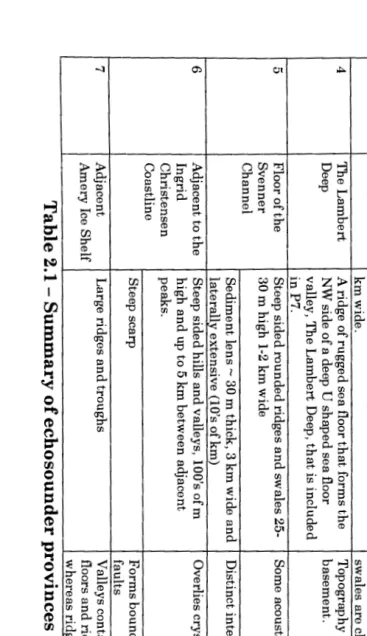
LIST OF TABLES TABLE 1.1 - GEOLOGICAL HISTORY OF THE VESTFOLD HILLS 9 TABLE 2.1 -SUMMARY OF ECHOSOUNDER PROVINCES ... .53
TABLE 2.2 - PRYDZ BAY ACOUSTIC UNITS TABLE 3.1 -WORKING SOLUTIONS FOR MOLYBDATE BLUE SPECTROPHOTOJI.ffiTRY ... 71
TABLE 3.2- RESULTS OF RADIOMETRICCARBBONDATING ... 74
TABLE 4.1 -DAILY AEOLIAN DEBRIS TRANSPORT RATES ... 89
TABLE 6.4 -SEDIMENT TRANSPORTV ALUES IN THE LAMBERT GLACIER ... 179
TABLE7.1-FEATURESOFTHEMAINFACIESOFPRYDZBAY ... 187A LIST OF PLATES PLATEE1-BOTTOMPHOTOGRAPHS- SITE 1 ... 246
PLATE E2 -BOTTOM PHOTOGRAPHS- SITE 2 ... 24 7 PLATEE3 -BOTTOMPHOTOGRAPHS- SITE2 ... 248
PLATE E4- BOTTOM PHOTOGRAPHS- SITE 3 ... 249
PLATE E5 -BOTTOM PHOTOGRAPHS- SITE 3 ... 250
PLATE E6 -BOTTOM PHOTOGRAPHS- SITE 4 ... 251
PLATEE7 -BOTTOMPHOTOGRAPHS- SITE4 ... 252
PLATE E8 -BOTTOM PHOTOGRAPHS- SITE S5 & 6 ... 253
PLATEE9 -BOTTOMPHOTOGRAPHS- SITES7 & 8 ... 254
PLATEE10- BOTTOM PHOTOGRAPHS- SITES 9 & 10 ... 255
PLATE Ell- BOTTOM PHOTOGRAPHS- SITES 11 & 12 ... 256
The following people and organisations deserve my sincere thanks for their assistance of the course of this project.
Dr. Andrew McMinn, my supervisor, whose enthusiasm for my project quite often exceeded my own.
My academic advisers, Professor Patrick Quilty and Dr. Phil O'Brien who provided valuable intellectual and logistic support.
Dr. Peter Harris for assistance with drafts and funding.
The Antarctic Co-operative Research Centre which provided the means to buy groceries and pay the rent.
The Institute of Antarctic and Southern Ocean Studies for administrative support.
The Bureau of Meteorology for the wind data from Davis Station.
The Australian Geological Survey Organisation and the Australian Antarctic Division for the use of equipment and services.
Mr. Ian Snape of the University ofEdinburgh for trace element analyses.
The Royal Hobart Hospital and Mr. Peter Cutforth for the use
ofX-radiography facilities.
Friends and colleagues from IASOS, University of Tasmania, the RSV Aurora
Australis, and Davis Station for the necessary social interactions.
Material being deposited in Prydz Bay is glaciogenic, aeolian, and biogenic.
Terrigenous material is entrained by basal glacial erosion and introduced to the
sea via iceberg rafting, meltout, and rollover in the periphery of Prydz Bay
where iceberg drift tracks are determined by ocean currents. It accounts for the
deposition of about 8 Mt a-1.
Aeolian processes transport debris from coastal oases into the manne
environment in the summer or onto fast sea-ice during the winter. Sea-ice
breaks out and releases the debris into the water column as it melts within a
few hundred kilometres ofthe source, accounting for approximately 1 Mt a-1 of
sediment.
The skeletons of phytoplankton settle to the sea floor directly or via the faecal
pellets of predacious zooplankton. Although production is geographically
uniform, the deposition of the resultant ooze depends on bottom currents
concentrating the fine material in deep water basins ( eg. Amery Depression).
Approximately 0. 7 5 Mt of such material is deposited annually.
The deposition of the remains of calcareous organisms is important in water
depths above 400 m, mainly on the shelf break, due to a shallow Calcite
Compensation Depth and Lysocline. Approximately 0.5 Mt of calcite is
deposited annually.
Sediments are reworked by iceberg turbation between 200 and 720 m water
depth producing iceberg turbate, an admixture of the current sediment supply
and underlying relict tills. Elsewhere, the sediment is a Siliceous Mud and
Ooze (SMO) which broadly represents the contemporary sediment supply.
Sedimentation rates are at the lower end of the range of Antarctic rates:
between 0.08 mm a-1 and 0.16 mm a-1. Were the sediments sourced from the
the Holocene are indicative of small scale climate change rather than any large
scale change required to affect the Lambert Glacier catchment.
The sub-surface sedimentology offshore from the Smsdal Glacier indicates that
a significant marine influence existed in the area during the last glacial
maximum, and the Lambert Glacier was not grounded in the Svenner Channel
during this period. The sub-surface geology of Heidemann Valley in the
Vestfold Hills also suggests that ice extent during the last glacial maximum was
not as extensive as previously thought, with glacial ice not extending as far as
the coast.
Prydz Bay
The continental margin of Antarctica has three large embayments: the Ross
Sea, the Weddell Sea, and Prydz Bay, each associated with significant ice
shelves. Prydz Bay (Figure 1. 1) is a triangular embayment in East Antarctica
(Hambrey eta!. 1991) situated on the coast between latitudes 68°E and 80°E.
It is bordered by Mac. Robertson Land and the Amery Ice Shelf to the
southwest and by Princess Elizabeth Land to the south east. Its maximum
dimensions are approximately 400 km east-west and 300 km north-south.
The continental shelf of Antarctica exhibits typical high latitude morphology
being deeply incised by glacial activity, producing coast parallel and coast
normal troughs (Vanney and Johnson 1985) with intervening banks and
depressions often surrounded by submarine moraines (Domack et a!. 1989).
Prydz Bay is deeper (more than 500 m) (Dunbar et a!. 1985) than shelf areas
around other continents due to factors such as isostatic adjustment to
continental ice loading, sediment starvation, and periodic erosion by advancing
ice sheets (Vanney and Johnson 1985, Quilty 1985, Cooper eta!. 1991). This
pattern can be explained by inner shelf erosion and outer shelf deposition with
lithospheric flexure due to ice loading being small in comparison (Ten Brink
and Cooper 1992).
Within Prydz Bay (Figure 1.2) one large basin, the Amery Depression, reaches
depths of greater than 750 m and has a north trending extension, the Prydz
Channel, with depths in excess of 500 m. The Four Ladies Bank in the north
east and Fram Bank in the north west of the bay are shallow features of around
200 m depth. The Amery Ice Shelf in the south west is a large floating ice shelf
fed by the Lambert Glacier. Two very deep (> 1000 m) features (Lambert and
Nanok Deeps) are located in front of the Amery Ice Shelf A crescentic
Vestfold Hills
[image:14.824.8.542.15.815.2]r
~
100 km 1Figure 1.1 - Antarctica and Prydz Bay location diagram and
Prydz Bay bathymetry based on AGSO data set.
200~M
BANKL-/)V5oo
70E
PRYDZ
CHANNEL
500
-()~_Jl~~)-
~~0+
Contours in metres (various intervals)
-....~
-....~ ~ 0
~'
~ Depression0
KilometresElevated land
0
66
s
A
2~¢
________; 1000
~29P
500~u~-
67SFOUR LADIES ~00
BANK ~
100
/ /
500
[image:15.824.78.500.98.634.2]Data base GEBCO worksheets High frequency perturbations on individual isobaths probably should be ignored being due often to navigation errors
These elongate features probably extend from well beneath the ice shelf in a
north-easterly direction extending some 100 km north of the current ice shelf
edge. A large, fault controlled channel, the Svenner Channel, trends to the
north-west of the ice shelf, parallel to the coastline at a distance of about 40
km. Stagg (1985) described the sea bed as generally smooth throughout the
bay, except in the southwest where it has been scoured by the Amery Ice Shelf.
Closer investigations reported herein reveal a more complex situation. Prydz
Bay lies at the oceanward end of a major graben, the Lambert Graben, which is
now occupied by the Lambert Glacier and Amery Ice Shelf. The Lambert
Graben extends some 700 km towards the south. It has bedrock depressions up
to 5 km deep onshore and possibly 10-12 km deep offshore in Prydz Bay
(Cooper et a!. 1991, Stagg 1985). Basement is composed of Precambrian
igneous and metamorphic rocks (Tingey 1982, 1991, Cooper et a!. 1991),
overlain by Lower Cretaceous and older continental rift strata, including a
series of [probably] glacially dominated sediments in what are described as six
acoustic units by Cooper eta!. (1991).
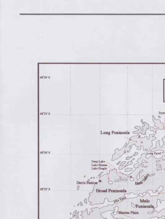
The Vestfold Hills
The Vestfold Hills (Figure 1. 3) occupy an ice free area of land of- 400 km2 on
the eastern side of Prydz Bay on the Ingrid Christensen Coastline between
latitudes 68°22'S and 68°40'S and longitudes 77 °49'E and 78°33'£. Most of
the sea floor within 5 km of the coast is less than 25 m deep (Tucker and
Burton 1987).
The Vestfold Hills are the most easterly and largest of a series of rocky coastal
outcrops that extend north-east of the Amery Ice Shelf (Adamson and Pickard
1986b ), bounded to the north west by Prydz Bay, to the east by the continental
ice sheet, and to the south by the Sersdal Glacier. The lines of hills consist of
three peninsulas, separated by fjords and valleys trending westwards from the
edge of the continental ice sheet, sub-parallel to the Sersdal Glacier. Mule
Peninsula to the south is bounded to the south by Crooked Fjord, the Sersdal
68.20' s
Vestfold Hills
68~25' s
Ice Sheet
68°30' s
ZvesdaLake
68"35' s 0
~ 0 ·. .r " Druzhby Lake
g \}, (! '7 ' ' ;/ Crooked Lake
68°40' s
·(}[J
!) 0
vt:D
~ChelnokLakeSotsda\ G\aciet
[image:17.824.6.540.16.723.2]77•50• E 78"00' E 78•10' E 7ff'20' E 78.30' E
The structural depression which forms Crooked Fjord is partially filled by
Crooked Lake. Marine Plain, a significant site of Pliocene marine
sedimentation, is on the northern shore of Crooked Fjord in the vicinity of
Burton Lake. Mule Peninsula is separated from Broad Peninsula by Ellis Fjord
which trends in an east-north-easterly direction from the sea to ice sheet. The
structural depression continues towards the ice sheet but swings around to
trend north-east/south-west. Here, Druzhby Lake and Zvesda Lake fill the
lower points of the valley. Approximately central in Broad Peninsula and
parallel to the Ellis Fjord I Druzhby system is a relic fjord called Death Valley.
Death Valley contains a series of hypersaline lakes, including Deep Lake and
Lake Stinear. Broad Peninsula is bounded to the north by Long Fjord which
extends east/west from the sea to the ice sheet. The northern peninsula, Long
Peninsula is bounded to the north by the sea and is bisected by the north/south
trending Tryne Fjord. To the north of the Vestfold Hills are two rocky
outcrops, the Wyatt Earp Islands (68°21.5'8, 78°32'E) and Walkabout Rocks
(68°22S,78°33'E) (not shown on Figure 1.2).
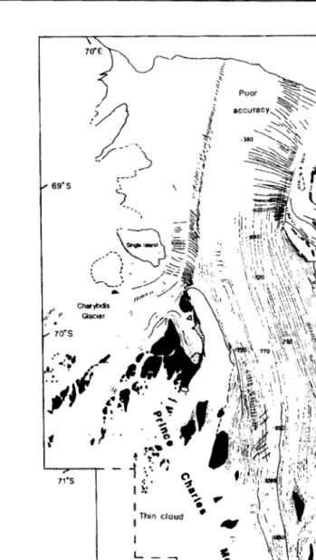
Lambert Glacier I Amery Ice Shelf (LGAIS)
The LGAIS occupies a major graben structure (Wellman and Tingey 1976,
Kurinin and Grikurov 1982, F ederov et a!. 1982 ) which extends into Prydz
Bay. This system (Figure 1. 4) is the largest glacial system in the world and has
been estimated to drain up to 20% of the East Antarctic ice sheet. While the
figures vary as to the amount of ice that passes through the system, amounts in
the order of 30 Gt a-1 (Allison 1979) have been mooted. According to oxygen
isotope studies on an ice core from the Amery Ice Shelf, up to 40% loss of ice
mass is by basal melting close to the grounding zone (Morgan 1972). One third
of this mass is replaced by the basal freeze accretion of saline ice sea wards of
the grounding zone where the ice decouples from the bed and begins to float
(Robin 1983). Most ofthe basal debris is believed to be lost very close to the
grounding zone while what is left is frozen in by bottom accumulation of saline
ice and therefore is probably transported to the edge of the ice shelf and
69"S
,,,:1'1 :-'
..
70"S~)~
,~
<
" Poor
2
.
:
,> v~
.
~},
"1:,'.
v .... ,
_t\
·- \. ~.1
,.-J ,:1
---- ~~
~
' il
---._
~t.
--~ "'~.. ~ .=:t.- ~
~
~~
_,--
. ---~ :::/
''"'
·-{
.
: .. -.0 ~ lj:~~--:;\ / -~ '•''•·
·-.._
-..
_..../ /
.. ,,rtt .. ·'. ,· ~-:
Char)t>dls •
Glacier ·:;
:·
..
-.,
~····: .
~.L.~-. .L.~-..L.~-.
.,.'
~~
·1t,
..
••
r .t
.,, ..
·
...
~71"S 1 • ~ ~
...
I •
Thin cloud " " "
I
L--,
,..-72"S No aata
..J
'< /
7J"S !~
'
..
·~ .... ~'.'1\11'''~,-·•"'' ... , _..,.,../
...
.·..
~\
'!--
~•
70'S, . rock outcrop
medial moraine
·=: foliation
:·~:_:,folded foliation
§~ crevasses
11·s ~" (well-defined)
72"S
approxlmala acale
0 50 100
lkml
73"S
c.rf.ttUSe..$
. . _, .... ·
1.\·'
'~:;:· \\, Ire
~~
··;
~x~wi
,:.,_
., ·l'
74"S
[image:19.824.97.447.63.681.2]66'E
Figure 1.4- The Lambert Glacier and Amery Ice Shelf-Structural glaciological map based on Landsat imagery. [after Hambrey 1991]
While the LGAIS is the major glacial influence in Prydz Bay, there are a series
of smaller outlet glaciers along the Ingrid Christensen Coast, draining a much
smaller area, probably only the coastal fringe. These include the Sersdal
Glacier, the Ranvik Glacier, the Polar Record Glacier and the Publications Ice
Shelf. Relatively little is known about these glaciers and their importance to
glaciogenic sedimentary processes in the study area.
GEOLOGY
The geology of the Prydz Bay area is characterised by large areas of complexly
deformed, high grade, polymetamorphic rocks (Collerson and Sheraton 1986,
Tingey 1991). Specifically, Archaean granitic basement of massive to poorly
foliated gneisses is exposed in the southern Prince Charles Mountains and the
Vestfold Hills (Oliver et a/.1982). Archaean metasediments and Proterozoic
pegmatites, granites, migmatite, amphibolite, slate, shale, quartzite, banded
iron formations (Stagg 1985, Hambrey 1991) are all intruded by a series of
Archaean to Proterozoic tholeiitic dykes and unmetamorphosed granites and
pegmatites of probable Cambrian age.
Younger sediments near Beaver Lake (Tingey 1982, Ravich & Federov 1982,
Stagg 1985, Tingey 1991) in the Prince Charles Mountains are part of the
Permian and Triassic Amery Group. These sediments consist of 250 m of
conglomerate, gritstone, siltstone and shale; 900 m of rhythmically bedded
sandstone, siltstone, claystone, and coal; and 200 m of arkose, coarse to fine
sandstone, and claystone. The youngest sediments occur in Prydz Bay where
Cainozoic glacial sediments overlie Cretaceous redbed sandstones (Hambrey et
a!. 1991). Quaternary sediments form a flat lying sequence ranging in thickness
from a few metres in inner and western Prydz Bay to nearly 250 m in the outer
or eastern parts of the bay. Of these, the uppermost few metres consist of
''Holocene diatom ooze and diatomaceous mud with a minor ice rafted
component" overlying Miocene to Quaternary massive to stratified diamictite
The geological and crustal evolution of the Vestfold Hills (Table 1.1) has been
a complex history of deformation of very old sediments and the intrusion of
various igneous rocks. It is characterised by an assemblage of gneissic
lithologies from both igneous and sedimentary protoliths (Collerson and
Sheraton 1986, figure 2.2). These gneisses have granulite facies mineral
assemblages. 1. 2. 3. 4. 5. 6. 7. 8. 9. 10. 11. 12. 13. 14.
Event -Age
{Ma}
Extrusion of protoliths of the Tryne metavolcanics; >3000 deposition of the Chelnok supracrustals, intrusion of
mafic igneous units.
High-grade metamorphism and deformation (Dt), £. 3000
partial melting of Tryne metavolcanics and emplacement of protoliths of the Mossel Gneiss Intrusion of mafic dykes.
Emplacement of dioritic to granitic intrusives 2400-2500
(Crooked Lake Gneiss and localised partial melting
of older units, deformation {D2}}
Formation of steeply dipping mylonitic shear zones {D3}
Intrusion of high Mg tholeiitic dykes c. 2400
Intrusion of dolerite dykes {Group I} c. 1800
Deposition of sediments, emplacement of granitic intrusives
Intrusion of abundant dolerite dykes (Groups II and £,_1375
III
Deposition of sediments including pelites and psammites.
Emplacement of tonalitic to granitic intrusives, £,_1100
deformation of granulite facies metamorphism of rocks in the Rauer Islands and south along the coast ofPrydz Bay, high-pressure metamorphism in the south-western part of the Vestfold Hills.
Intrusion of anorogenic granites and pegmatites. c. 650-400
Intrusion of alkaline dykes.
Rifting and separation of Antarctica from India, £,_115-80
Madagascar, and Africa.
Table 1.1 -Geological History ofthe Vestfold Hills-Rauer Islands [after Collerson and Sheraton 1986, Table
[image:21.824.118.472.188.679.2]There has been a complex polyphase deformational history including the
intrusion of an intensely concentrated mafic dyke swarm (Black et al. 1991,
Lanyon et al. 1993). Three distinct east-west trending gneissic units have been
mapped (Crohn 1959, Ravich 1960), although subsequent geological mapping
continues to highlight the complexity of the geology and the difficulty in its
interpretation.
The more recent geology of the Vestfold Hills is typical of many ice free
coastal areas where the older basement rocks are covered with a veneer of
Cainozoic glacial and marine sediments. The oldest sediments in the Vestfold
Hills are the marine deposits of Pliocene age in the Marine Plain area
(Adamson and Pickard 1986a, Quilty 1992). These sediments contain
diatomaceous sands, a thin glacial unit and opal cemented units. There is a
diverse invertebrate fauna, and cetacean fossils are also found in these
sediments.
Sediments deposited by a series of Quaternary glaciations are common
throughout the hills. The Vestfold Glaciation (c. 20- 14 ka) resulted in glacially
polished, striated and fractured rocks, roches moutonnee and ice pluck features
which occur across the hills at all elevations (Adamson and Pickard 1986a).
During this glaciation, the ice sheet reached at least as far as the offshore
islands which have morainal ridges. The predominantly north-east trending ice
movement stripped and plucked the Archaean basement. Other minor valley
glaciation occurred in the north east of the hills and in the vicinity of Druzhby
Lake (Adamson and Pickard 1986a).
The Vestfold Hills may have been covered by up to 1 000 m of ice during the
Vestfold Glaciation in the late Pleistocene. During the Holocene the ice sheet
melted back allowing the land to rebound isostatically, now at a rate of 1 to 1. 5
mm a-1. During this overall retreat there were at least two minor readvances,
one building moraine ridges on Broad Peninsula, and the northwards surge of
Pickard 1984). Sedimentary deposits in Heidemann Valley have been linked to
these two advances by Hirvas et al. (1993).
PREVIOUS WORK
The study of the sedimentology of Prydz Bay and the surrounding areas is in
its infancy. There have been relatively few studies conducted in the area, and
until the mid 1980's, none of these had been particularly comprehensive. In
1873, theHMS Challenger Expedition collected a single sample from the north
east of Prydz Bay. In 1982/83, the Australian National Antarctic Research
Expeditions (ANARE) conducted a marine geoscience cruise (Quilty 1985,
Stagg 1985). The Ocean Drilling Program (ODP) drilled five holes in a section
extending to the north west of Davis Station in the 1987/88 (Barron et al.
1991), the very important results of which are reviewed in Chapter 2. In
1990/91, grab and core samples were collected during the Australian Antarctic
Marine Biological Ecosystem Research (AAMBER) Expedition undertaken by
ANARE in the RSV Aurora Australis (Franklin 1991,1993). In 1992/93 the
Krill and Rock (KROCK) voyage of the Aurora Australis collected grab, core
and dredge samples (O'Brien et al. 1993). This thesis and associated
publications report some of the results from the KROCK voyage and the
results of a sampling program conducted over the summer season of 1993/94
wherein approximately 250 samples were collected in the Vestfold Hills and
surrounding coastal areas. Subsequent programs have been conducted but are
not reported in this thesis. These include a marine geoscience cruise of the RSV
Aurora Australis and a number of studies undertaken by Russian scientists, the data from which are not readily available, due to disputes over ownership (Pers
comm Dr. Phil O'Brien).
RATIONALE
While the study of polar sedimentology is well established, there has been little
attempt to apply methods and techniques from other areas to the modern
sampling programs undertaken there. With the advent of the Antarctic
Co-operative Research Centre in Hobart in 1992, a focussed effort to study the
sedimentary record in Prydz Bay commenced, with a view to investigate
climate change over the last five million years. Because the globe is currently in
an interglacial period, it is very difficult to determine what sedimentary
processes occur during periods of glacial maximum. In addition, the action of
advancing glaciers and ice sheets tends to remove the traces of the previous
interglacial sedimentary patterns. On a more local scale, the peripheral advance
and recession of the Antarctic ice sheet during the Late Quaternary is poorly
understood (Domack et al. 1989).
The problem facing workers in Prydz Bay is to develop an understanding of
sedimentary processes occurring during interglacials as well as to infer, from
secondary evidence, those processes which occur during glacial maxima. Of
most use is the location of areas where sediments from previous interglacials
are preserved. The study of such locations would allow workers to trace the
changes which have occurred in the sediments due to the changing climate
conditions.
While the previous programs have provided in excess of 200 sampling sites,
they have mainly been reported in isolation. This thesis will reinterpret the data
from these studies in light of the material collected by the author over the last
few years and will:
a. Identify the processes eroding, transporting, reworking and depositing
debris in the marine environment in Prydz Bay.
b. Describe the facies resulting from the interaction of these processes.
c. Identify the structural and textural indicators of those processes in the
resultant sediments and identify the key indicators that can be used to identify
d. Develop a preliminary sediment budget for Prydz Bay and the Ingrid
Christensen Coastline, against which data gathered in Prydz Bay in the future
can be compared.
CONTENT OF APPENDICES
Appendix A - Locational Data
Appendix A provides locational data for all samples collected for this study, as
well as material collected by others and used for this study.
Appendix B - Grain Size Data
Appendix B contains tables with the gravel/sand/mud proportions and sand
grain size distributional data .. Not all samples were analysed by all methods.
For instance, sediments mostly consisting of fines were not analysed for sand
grain size statistics.
Appendix C - Heidemann Valley Drill Hole Core Logs
Appendix C contains core logs for the eight drill holes taken in Heidemann
Valley.
Appendix C - Prydz Bay Bottom Photographs
Appendix E contains bottom photographs collected by Prof Pat Quilty.
Appendix E - Trace Element Geochemical results
Appendix E contains the results of trace element geochemistry.
Appendix F- KROCK Core Logs
Appendix G - Papers Arising
Appendix H contains other papers which have arisen from this study and have
already been published or are in the process of being published. These include
the description, for the first time, of preserved parts of the algal Order
Parmales in the sediments of Prydz Bay (Franklin and Marchant 1995,
Appendix G) and secondly, a study of the 14C reservoir effect in Prydz Bay
Introduction
Research on the sedimentology of Prydz Bay is in its infancy. Even though
HMS Challenger collected a sample to the north of Prydz Bay in 1873, very little attention was paid to Prydz Bay until the 1980's when systematic seismic
and sedimentological sampling commenced. Nonetheless, there is a wealth of
data on the sedimentology of the polar regions, from both the north and south,
and this section will review the literature on glacial and glaciomarine
sedimentology. It concentrates particularly on Antarctic sedimentology and
Prydz Bay.
FACIES
Nicholas Steno introduced the term "facies" to the geological literature in
1669, but it was first used in the modem sense by Amanz Gressly in 183 8
(Boggs 1987). Since this time, the term has been applied in many different
ways and, consequently, the usage has become confused, with extended
meanings being applied even to non-stratigraphic usage such as metamorphic
facies.
Definition.
Hambrey ( 1994) defines a sedimentary or lithofacies as a body of sediment or
rock with specified characteristics. One useful definition of sedimentary facies
is found in Whitten and Brooks (1972), who describe facies as
"The sum total of features such as sedimentary rock type, mineral
content, sedimentary structures, bedding characteristics, fossil
content, etc which characterise a sediment as having been deposited
by rock type are referred to as lithofacies, whereas those especially
characterised by their fauna are called biofacies. "
Sedimentary environments and sedimentary facies are different with
environments being determined by physical characteristics such as physical,
chemical and biological parameters. These parameters result in the deposition
of a body of sediment having particular structural and compositional properties
known as facies. This study will use the term ''Facies" to
mean-rocks/sediments deposited by the action of a discrete set of
processes resulting in an identifiable sediment distinguishable from
other sediments.
The Glacial and Glaciomarine Environment
The importance of the glacial environment can be emphasised by its extent.
Glaciers currently cover 10% of the earth's land surface, mainly as large ice
sheets in Greenland and Antarctica. This figure may have reached as much as
30% during the Quaternary glaciation and as a result glacial deposits are
widespread (Reading 1978).
The glacial environment is, sensu lato, a composite environment including
fluvial, aeolian, and lacustrine environments, and may include parts of the
shallow marine environment. Glacial deposits make up a small part of the
stratigraphic record as a whole. Precambrian to Late Cainozoic glacial
deposits are reviewed in Anderson and Molnia (1989) and include deposits of
probable glacial origin in the Huronian in North America and the Griqualand
West and Transvaal Basins of South Africa (Visser 1971); in the Hamersley
Basin of Western Australia (Trend ell 1981 ); Late Precambrian deposits from all
continents except Antarctica (Hambrey and Harland 1981 ); and a large amount
The glacial environment is confined to areas with more or less permanent
accumulations of snow and ice. Glaciers are formed by accumulations of snow
above the snow line where snow does not entirely melt away in the summer.
Definitions of the glaciomarine environment all centre on the interaction of
glacial ice or sea ice and the sea. It includes all those areas where sediment is
deposited in the sea after release from glacier ice or sea ice (Dowdeswell and
Scourse 1990), or where glaciers reach the sea and influence sedimentation
(Hambrey 1994). The processes involved in glaciomarine sedimentation are
complex with a variety of sediment sources being affected by glaciological,
oceanographic, and biological processes.
In Prydz Bay, any discussion of sedimentation or sedimentary processes and
the resultant facies must be framed around the premise that these two
environments are contiguous. To date, different workers have used the terms
"glacimarine", "glacial-marine", "glacio-marine", and "glaciomarine". The term
"glaciomarine" will be used herein unless quoting other usages. The definition
ofthe term "glaciomarine environment", for the sake of this study, is:
The glaciomarine environment incorporates all areas, both
terrestrial and marine, where ice or cryogenic processes are
involved in the erosion, transportation, deposition, and
reworking of sediments.
In Antarctica, the glaciomarine environment extends from the continental ice
sheet where cryogenic processes erode and entrain sediments, to the north of
the polar front as far as the influence of floating icebergs which raft sediment
continues.
PROCESSES OF THE GLACIOMARINE ENVIRONMENT
Introduction
The glacial environment is divided into a number of constituent and
Discussions of glaciomarine processes and sediments in the literature are
usually based on events in these zones. Edwards (1978) divided the glacial
environment into the "subglacial" zone which is influenced by contact with the
bottom of the glacier, the "supraglacial" zone which is the upper surface of the
glacier, the "ice-contact" zone around the margin of the glacier, and the
"englacial" zone within the glacier itself. Environments around the margins of
the glacier influenced by melting ice but not in direct contact with the ice are
the "proglacial" environment which includes the "glaciofluvial",
"glaciolacustrine", and "glaciomarine" environments. The area extending
beyond and overlapping the proglacial environment is the "periglacial"
environment (Boggs 1987).
The glaciomarine environment has been variously described. Reading (1978)
described it in terms of the sediment deposited. It has also be described by
proximity to the glacial sedimentary source (Molnia 1983, Eyles and Miall
1984), by glacial type (Anderson et al. 1983), and by major setting (Hambrey
1994) and by the sediments deposited (Powell 1980).
Reading (1978) identifies sediment types based on grain size parameters and
sedimentary structure. Eyles and Miall (1984) discuss the glacial-marine
environment in terms of the facies deposited, which they divide into proximal,
medial and distal facies.
Hambrey ( 1994) discusses the glaciomarine environment by dealing separately
with fjord environments and then follows on with a discussion centred around
differences in sedimentary processes. All of these approaches are valid but the
close relationship of environment, process, and sediment requires an integrated
approach. Any environment can be considered as the sum of the processes,
both static and dynamic, which constitute that environment. It is the response
to the processes that is recorded in the stratigraphic record and it is these that
need to be codified.
Entrainment processes cause sediment to be supplied to the medium which will
to, subglacial, aeolian, and fluvial erosion and transport, englacial transport,
and sea-ice freeze in.
Other important processes identified are slumping, debris flow, and turbidity
currents (Anderson et al. 1980b, Pudsey et al. 1988). Transport and
depositional processes are those which transport and release entrained
sediment to the marine environment. They include sea-ice and iceberg rafting
and subsequent meltout of sediment, subglacial fluvial processes, vertical and
autochthonous accumulation of biological remains, aeolian transport, and
sediment gravity flows.
Reworking processes affect the nature of the sediments after they are deposited
on the sea-floor. They include the mixing of sediments by iceberg and
biological activity and the winnowing of fines by bottom currents
A number of other factors affect the distribution and deposition of material in
the glaciomarine environment. These include, but are not limited to, continental
shelf physiography, biogenic productivity, water mass circulation and sea ice
fluctuations (Domack et al. 1991a).
For this section, the proce.;ses will be segregated into two main groupings, the
biological and physical processes. The biological processes are those
associated with the action of living organisms; productivity, in situ
accumulation of bioclastic material, and bioturbation. The physical processes
are all the rest of the processes, those associated with the erosion, transport,
and subsequent reworking of clastic material by moving fluids (ice, water, and
air).
Biological processes
Introduction
Deposition of the remains of once living organisms occurs throughout the
marine part of the glaciomarine environment. Calcareous and siliceous
directly to the bottom as part of the marine snow, or are predated and settle in
faecal pellets.
The in situ deposition of biogenic material occurs in the sub-marine zone on
the sea floor. Calcareous and siliceous benthos die and their remains
accumulate in the sediment. While avoiding UV light in the top 10 m, within
the photic zone, most organisms are represented. Below the photic zone,
plants are absent. The accumulation of calcite is dependent, also, on the water
chemistry. If the water is undersaturated with respect to CaC03 then calcite
which is deposited will be dissolved. Dissolution of calcite is discussed in detail
later. Carbonate plants and siliceous phytoplankton are restricted to the photic
zone.
Biogenic silica
Diatoms bloom in the surface waters of polar seas in the summer after
cryophilic diatoms are released from melting sea ice and act as an inoculum
(Krebs 1983), and later settle through the water column. Nutrient availability
affects faunal and floral growth so facies may vary with nutrient levels
(Heinrich et al. 1992). Sea ice plays a major role in the control of surface
productivity by providing stable microenvironments and allowing
phytoplankton blooms during the summer sea ice breakup. This process will be
discussed in detail later.
Sediment trap experiments in the central and western Ross Sea suggest that
nearly all biogenic opal delivered to the mid and deep water column consisted
of unbroken diatom tests of the genus Nitzschia, many of which settled within
faecal pellets (Dunbar et al. 1991). Gersonde and Wefer (1987) estimate that
up to 50% of biogenic silica particles are incorporated in the faecal pellets of
Euphausia superba (Antarctic krill), and other zooplankton such as E.
crystallorophias (Crystal Krill). Dunbar et a/. ( 1991) reported large spatial variation in the magnitude and style of vertical biogenic sediment flux. This
variation may be due to many things such as hydrography (Scharek et al. 1994)
and the limited availability of silicon (Nelson and Treguer 1992) and iron
(Brandini 1993).
In Prydz Bay this style of accumulation of biosiliceous material results in the
deposition of Siliceous Mud and Ooze (SMO) which is one of the most
widespread modern surficial sediment types, and is the most abundant surficial
sediment (Anderson et al. 1984). Many of the deep glacial troughs of the
Antarctic continental shelf are currently being filled with SMO. Dunbar et al.
(1989) conclude that biogenic deposition dominates sedimentation in
McMurdo Sound. In Bransfield Strait, the total flux of debris reaching
sediment traps deployed in the study ofGersonde and Wefer (1987) was in the
order of2.9 to 4.3 g m-2 daf\ ofwhich up to 60% was biogenic silica.
Biogenic carbonate
Extensive carbonates are now forming at high latitudes in the seas off Europe,
Canada, and Antarctica (Rao 1996). Polar carbonates in the past formed
contemporaneously with glaciation during the last glacial maximum (Taviani et
al. 1993) and continued later during the rise of sea level (Wilson 1988) and
during the subsequent retreat of glaciers to their present position (Domack
1988, Rao et al. 1995, 1996).
Polar carbonates are composed mostly of skeletal hashes with petrographic
counts of relative percentages of biota indicating that carbonate biota is mostly
confined to the gravel and coarse sand fractions. The gravel fraction contains
mainly bivalves, echinoderms and serpulid worms while the sand fraction
contains foraminifera, bryozoa, and minor bivalves (Franklin 1991, 1993, Rao
1996, Rao et al. 1995, 1996)
Among the many controls on bio-carbonate accumulation rates is high turbidity
as it is an environmental stress for CaC03 organisms. As a result, areas with
high carbonate accumulation rates are therefore probably not affected by
significant turbidity (Domack 1988). Other major controls on the genesis of
bio-carbonates include saturation levels of CaC03, and the rate of carbonate
formation (Rao 1996).
Saturation levels of CaC03 in the water, when low as they are in Antarctica,
restrict the growth of carbonate organisms or dissolve their skeletons after
death. Finally, the rate of accumulation of carbonate (relative to terrigenous
accumulation) is a factor in the formation of carbonate sediments.
Biogenic rafting
Many species of benthic macroalgae use rocks on the seafloor as anchors and
use buoyant gas filled vesicles to maintain an upright position. Gilbert ( 1984)
showed that the alga Fucus vesiculosus (L. ) was able to transport stones to
which it was attached. In addition, algae attached to stones may be frozen into
sea-ice. Gilbert (1990) argues, that while it is difficult to quantify the relative
importance of this process, it is important to recognise that it occurs because it
may be possible for algal rafting of large stones to occur over great distances.
If this is the case, and cobbles are then deposited in fine sediments, it may be
possible to misidentify such a sediment as having been influenced by ice rafting.
Bioturbation.
Living organisms such as molluscs, crustaceans, worms (Hambrey 1994) and
foraminifera (Franklin 1991, 1993) which are sparsely disseminated through the
sediment play an important role in the mixing of that sediment (Jones and Jago
1993). Such mixing or bioturbation is common in glaciomarine sediments and
can be recognised by mottling in sediment cores and by the presence of
infaunal organisms. Much ofthe structureless sandy mudstones and diamictites
in cores from McMurdo Sound have been interpreted as once stratified
sediment that has been bioturbated (Hambrey 1994).
Nearly all of the Late Cretaceous to Quaternary strata from ODP Leg 119
cores were completely bioturbated with ichnofabric (sedimentary rock fabric
resulting from bioturbation (Ekdale 1984)) indexes commonly around 6
(Droser and Bottjer 1991). Bioturbation occurs at varying depths in the
sediment with Broecker and Peng (1982) demonstrating bioturbative activity to
a depth of7 em in deep sea cores. Droser and Bottjer (1991) identify a zone of
high bioturbation down to - 8 em (below sea floor) and a zone of reduced
biological activity down to- 20-35 em in Leg 119 cores.
Summary
Biogenic processes on the Antarctic continental shelf are currently resulting in
the deposition of biogenic siliceous muds, not only as SMO in deep and/or
protected basins, but as a component of all glaciomarine sediments. These
biosiliceous materials are sourced mainly from phytoplanktonic productivity in
the surface waters in the summer, constrained, to a major degree by sea ice
breakup in the early summer. Siliceous skeletons settle directly, or VIa
zooplanktonic faecal pellets, to the sea floor. Calcareous sediments are
accumulating in shallow. areas near the coast and around the continental shelf
break where nutrient levels are high and post-mortem dissolution of CaC03 is
minimal. Bioturbation is a common process which can homogenise surface
sediments to a depth of 8 em and may act down to depths of 3 5 em. Minor
rafting of rock clasts by buoyant algae has been observed but is unlikely to play
an important role other than locally.
Physical processes
Aeolian processes
Aeolian processes are those associated with the erosion, transport, deposition
and reworking of debris/sediment by the wind. In some areas aeolian
deposition is significant (Dunbar et al. 1985). For instance, aeolian dust is a
major sediment source in the deep ocean basins with up to 80% of
accumulated material in some areas (Pye 1994, Nickling 1994).
Terrigenous material is entrained by the wind via both the erosion of rocks by
deposited sediments by saltation. As a result, these processes are only
important in areas of exposed basement or sedimentary material.
Bagnold (1941) identified three distinct modes of aeolian transport: suspension
transport which moves small particles of 50 J..Lm (Gilbert 1990) or between
60-70 J..Lm (Bagnold 1941 ); saltation of large particles ( 60-1000 J..Lm) and; surface
creep oflarge particles (>500 J..Lm) (Gilbert 1990).
Silt, sand, and gravel (cobbles up to 128 mm diameter) have been located up to
5 km from their likely source (Gilbert 1990) where they were trapped in
sastrugi, implying that transport could have continued to greater distances.
Under ideal conditions of unlimited sediment supply, aeolian transport rates
may reach 1 Mg h-1 (mega grams per hour) per metre width at wind speeds of
16 m s-1 (Bagnold 1941 ).
The movement of sediment by the wind can be described with the same
mathematical expressions used to describe water transport of sediments. Air
works as a fluid and the amount of sediment and maximum grain size moved is
dependent on the fluid (wind) strength and density (discussed later).
In Antarctica, aeolian processes are not generally important but may be locally
important. The addition of wind-blown material to the top of glaciers is
dependent on the availability of ice-free areas of rock and or sediment.
Sediments can be introduced to the supra-glacial zone directly by the wind, or
via the meltout from snow-drifts. Significant aeolian deposition to the top of
sea ice (Clark and Hanson 1983) occurs during the winter months when sea ice
covers the sea adjacent to areas where rocks and pre-existing sedimentary
deposits are located.
Barrett et al. (1983) concluded that aeolian sand initially deposited onto
sea-ice is the major source of sediment on the floor of western McMurdo Sound.
When sea ice is not present during the summer, aeolian sediments are delivered
The major sources of debris are ice-contact sediments exposed by isostatic
rebound (1-1.5 mm a-1 in the Vestfold Hills, Adamson and Pickard 1986a),
glacial retreat, and fluvial and lacustrine sediments exposed during periods of
low water (Molnia 1983).
During winter, aeolian transport is arguably more effective because winds are
stronger. The temperature is colder, resulting in denser air, although this effect
is probably negligible. In addition, during the winter, much of the land surface
which is not covered with permanent ice is covered with snow drifts, reducing
the area of rock and soil exposed to the wind. As a result, this process is only
important locally, and at certain times of the year, after snow fields have melted
and before the sea-ice breaks out, and then only in the vicinity of ice-free areas.
Sediments entrained by wind are typically very well sorted, fine grained, with
individual grains displaying surface textural characteristics such as surface
smoothing and rounding (Nickling 1994), although the final gram stze
distribution of aeolian sediments is probably strongly dependent on both the
source material and the climatic regime. The action of wind erosion is also
evident in the formation of facets on exposed rocks (ventifacts).
To summarise, aeolian erosion, transport, deposition, and reworking of
debris/sediment is a locally important process which moves material up to
coarse sand size (or larger in some instances) from areas of exposed rock and
sediments. This material is deposited directly into the marine environment in
summer, onto sea ice in the winter, and onto glaciers throughout the year.
Mathematical models.
Dingler eta/. (1992) reviewed the literature to determine the most appropriate
mathematical models for the prediction of aeolian sediment transport. The
major shortcoming with the theoretical work conducted to date is that it has
been developed for dry, reasonably fine sediments, such as those on beaches.
Also the presence of salt in the sands may significantly affect the applicability
of the theoretical mathematical models of wind driven sediment transport
(Dingler et al. 1992).
Dingler et al. (1992) contend that the entrainment of sand is a function of the velocity of the wind, such that
q= CU• 3 Equation 2.1
where q is the transport rate (g cm-2 s-1),
u.
is the shear velocity, and C is a grain size dependent constant. Most workers agree that transport rate is relatedto the cube of the shear velocity.
Because the theoretical models so far developed are of use only in
environments of fine grained, dry, salt free sediments, this study is not able to
make use of them. The Vestfold Hills, and in particular, Heidemann Valley,
contain sediments of greatly diverse grain size, from boulders to very fine
diatomaceous material which have been deposited in a coastal marine
environment, and glacial sediments that have been submerged in marine waters.
As such, there are significant amounts of marine salts, and certainly water,
incorporated in these sediments. For these reasons, the application of the
theoretical models of aeolian wind transport without qualification is not
practical
Sea ice processes
In the Arctic, the littoral (coastal/shallow coastal) environment is the only one
in which the incorporation of sediments into sea ice is important (Gilbert
1990), and this is probably also the case in Antarctica. Sediment is
incorporated into sea-ice when aeolian and tluvially transported sediment is
deposited on top of it, when the sea-ice is in contact with the bottom sediments
and sediment is frozen in, when fine grained suspended sediments are frozen
into anchor ice during its formation, and when anchor ice rising through the
Freeze-in occurs in areas where coastal waters shoal to less than the maximum
seasonal sea ice thickness and is best developed where there are broad
intertidal flats. Sediment loads can reach as much as 670 g
r
1 in the Arctic(Gilbert 1990). Debris rich bands which form at low tide are interfingered with
clear bands forming at high tide and there is no sorting of sediments in the
process with grain size distribution of sea ice debris closely reflecting that in
the underlying sediment (Gilbert 1990).
Fine grained suspended debris can be incorporated into growing sea ice, when
frazil and anchor ice formed in the initial stages of freeze up, scavenge
suspended material from the water column or sea floor. This results in a
uniformly darkened layer (Gilbert 1990). Sediment loads have been measured
in the 10's of grams
r
1 (Gilbert 1990) in the Arctic, and up to 1.6 gr
1 (Barneseta/. 1982).
Anchor ice formation is best developed where temperature conditions allow ice
to form and accumulate on the seafloor. For instance, areas which are exposed
at low tide may become sufficiently cooled to allow the ice to form on the
substrate when the tide rises. When the buoyancy of growing patches of this
ice is sufficient, it will lift from the surface and carry with it sediments from the
sea floor and these can eventually be incorporated into sea ice (Gilbert 1990,
Reimnitz et a/. 1987)
Sea ice transport of terrigenous material in Antarctica is poorly described and
is probably dependent on the presence of a clastic shoreline to act as a debris
source. Nonetheless, sea ice transports and deposits sediments in a similar
manner to icebergs, but on a smaller scale. Observations of sediment
concentrations in sea ice in Antarctica are few but average particle
concentrations of sediment in sea ice in the Beaufort Gyre, Arctic ocean, is
much higher (40 mg
r
1) than in sea water (0.8 mgr
1) (Reimnitz eta/. 1993).Sea ice, once decoupled from the shore, is driven by wind more than ocean
currents, as sea ice is only, at most, a few metres thick compared to icebergs
with hundreds of metres draft.
Melt rate for sea ice is also different as sea ice is saline and therefore melts at a
lower temperature than does glacial (fresh) ice. Sea ice meltout involves the
establishment of pools on the top of the sea ice which subsequently melt
through the ice and drain the surrounding area (Gilbert 1990, and references
cited) as well as the melting of sea ice from the bottom up.
Sediments arising from sea ice rafting form drops, dumps, and aggregates.
Grain size ranges from clays to boulders (most commonly at the finer end of
that range) decreasing in size distally from the source. Sorting is poor to good
and clasts may be angular to rounded, and possibly striated. Fabric is poorly
developed and may contain transported faunal and floral material. The
transport distance of these sediments from the source is less than for iceberg
rafted sediments and deposits can occur in any depth of water.
Sea ice not only transports sediment, it also plays a major role in controlling
surface productivity. Sea ice meltwater creates an environmentally stable zone
which is quickly exploited by phytoplanktonic blooms (Smith and Nelson
1986a&b ). Areas which undergo seasonal fluctuations in sea ice cover
therefore contribute significant quantities of biogenic detritus. This process
may be important in controlling the siliceous facies distribution as well as
influencing the carbonate facies by the advection of planktonic productivity to
the benthos (Domack 1988).
Sea ice scouring is similar to iceberg scouring but operates at much shallower
depths and is confined to shallow water (Drewry 1986), although below
pressure ridges it may occur to depths of30 m (Hambrey 1994)
In summary, sea ice is an effective debris transport mechanism. Debris
deposited on, or incorporated in, sea ice is moved by the prevailing wind until
the sea ice melts and releases the debris load. Sea ice melts at a lower
temperature than glacial ice and most of the entrained debris is probably
released relatively close to the source. Sea ice is also an important agent in the
phytoplanktonic cycle because, as it melts, it provides a stable
microenvironment which is exploited by blooming phytoplankton in the early
summer.
Glacial processes
Glacial advance and retreat is affected by global and local climatic variations.
The retreat of northern and southern hemisphere ice sheets during the Late
Pleistocene and early Holocene is probably due to quite different causes. In the
northern hemisphere the most recent retreat was probably caused by
Milankovich summer insolation while the Antarctic ice sheet retreat was
probably a response to the resultant sea-level rise and global warming (Harris
eta/. 1996, and references cited).
Antarctic ice sheet response to global climate fluctuations may not occur in an
obvious fashion. A 5°C increase in global temperature may result in short term
mass accumulation rather than ablation due to the increased precipitation
resulting from temperature increase (Domack et al. 1991b). Domack et a/.
(1991 c) discusses the possibility of the advance of some East Antarctic outlet
glaciers during the Hypsithermal, a period of warm conditions identified in
palaeoclimate records between 7 and 4 ka (Pielou 1991).
Glacial processes include erosion beneath the ice sheet and outlet glaciers,
deformation of previously deposited sediments beneath moving ice,
incorporation of debris in glacial ice and the subsequent transport of that debris
to the coast, and finally the deposition of sediments beneath, and adjacent to
moving glacial ice. Transport and deposition subsequent to iceberg calving is
discussed later.
In Antarctica about 99% of the continent is ice covered and subglacial erosion
is the primary erosive process (Anderson et al. 1983). Glacial erosion includes
several discrete processes including abrasion and fracture of structurally
homogenous rock, and fracture of jointed rock, followed by the entrainment of
resultant debris into the basal zone of the glacier by pressure-melting regelation
and direct freeze on (Anderson et a/. 1983, Hambrey 1994). The erosive
effectiveness of a glacier is controlled by the thermal regime, with wet-based
glaciers being very effective and cold dry glacial regimes being incapable of
significant erosion, transport, or deposition (Anderson et al. 1983 and
references cited).
Abrasion is the production of fine grained material by the scoring of bedrock
by debris laden ice (Hambrey 1994). Factors affecting the degree of glacial
abrasion are the presence of basal debris and the velocity of the glacier. Less
important is ice-thickness (affecting downwards pressure), presence of water
(water reduces the downward pressure), the relative hardness of basal debris
and bedrock, and the size and shape of basal debris particles. The relative
importance of these factors varies according to the thermal regime of the
glacier, with cold glaciers tending to be less effective agents of erosion
(Hambrey 1994). In Antarctica, erosion at the base of moving glacier ice
provides most of the debris that is transported from the continent (Hambrey et
al. 1992).
Glacial erosion can be identified after the event by major landforms such as
glacial troughs, and cirques, medium scale landforms such as roches
moutounnee, and small scale features such as polished and striated pavements
(Hambrey 1994). Another indicator is erosion surfaces with reverse
(shoreward) gradients (Anderson eta/. 1994). At the grain scale, evidence of
glacial erosion can be seen in striations on large clasts.
The glacial processes to be discussed here are those which are directly related
to the action of glacial ice.
As outlet glaciers increase in size, and the grounding lines move to seaward,
previously deposited sediments are "bulldozed" by the grounded ice. This
produces moraines and laterally transposes the results of previous cycles of
sedimentary deposition.
When a glacier moves over an unconsolidated sediment, there is a coupling

![Figure 1.2 - Geomorphology of Prydz Bay - showing major features. [ after Quilty 1985]](https://thumb-us.123doks.com/thumbv2/123dok_us/8466120.339307/15.824.78.500.98.634/figure-geomorphology-prydz-bay-showing-major-features-quilty.webp)


![Table 2.2 - Prydz Bay acoustic units- interpretations [after Cooper et aL 1991]](https://thumb-us.123doks.com/thumbv2/123dok_us/8466120.339307/68.810.79.470.144.388/table-prydz-bay-acoustic-units-interpretations-cooper-et.webp)