DEVELOPING A SYSTEM FOR THE
INTEGRATED MANAGEMENT OF
FOREST ROADS AND TRANSPORT
Andrew Edward Winter
January 1999
STATEMENT OF ORIGINALITY
I dclare that the work submitted is my own except where acknowledged otherwise.
Signed:
. /J
ABSTRACT
The efficiency of roadmg and log transport has a major impact on the forest environment and on
the cost of delivering wood to the mill. Sound management aims to minimise the environmental
impacts, such as degradation of water quality, of forest roads and transport systems while
providing for efficient log transport. A system was developed to help forestry organisations
achieve these aims.
A pilot-scale forest road management system (FRMS) was developed to allow the collection,
storage, display and analysis of a wide range of forest road and transport data. The FRMS
utilises spatial analysis capabilities of a Geographical Information Systems (GIS). Data
collection procedures were developed that used Global Positioning System (GPS) units with
integrated electronic data loggers. A non-computer based pen and paper method was also
developed as a backup for circumstances where GPS was not available. These techniques were
trialled and a complete dataset for the roads of a section of Bago State Forest tin southern NSW)
was collected. This dataset was used as an example during development of the FRMS.
The dataset included attributes of road sections as well information about the location and
condition of associated assets (eg. bridges, culverts) and defect areas (eg. potholes, eroded areas).
The FRMS was designed to include information on log truck travel times, related to route
segments, which can be used in the management of haulage operations. Collection and addition
of log truck travel time data to the FRMS was trialled.
The FRMS was developed to a pilot-scale to prove the concept. The application of the system in
supporting the achievement and demonstration of environmental compliance, systematic road
inspection, log transport management and road works planning was successfully tested with the
Collecting the initial dataset required to implement the FRMS was recognised as the major cost
for forestry organisations adopting such a system. A study to determine the likely cost of
collecting the initial dataset required for the FRMS showed that it will cost around $0.92/ha of
ACKNOWLEDGEMENTS
Acknowledgement is extended to my employers, State Forests of NSW, for providing financial
support for the development of the pilot-scale Forest Road Management System and for awarding
me leave of absence to complete this research. The Forest and Wood Products Research and
Development Corporation provided support for the Log Truck Travel Time component of the
study in East Gippsland, Victoria. CSIRO Division of Forestry and Forest Products must also be
thanked for providing the stipend for this study. This research was undertaken as part of the
Forest Technology Program.
Dr. Bob McCormack was invaluable in providing direction for the project and the contribution he
made to this study, as well as his efforts in promoting Forest Operations research in general, is
warmly acknowledged. My academic supervisor, Dr. Jimin Tan, is thanked for his support,
especially for his work in editing the thesis.
Mr Andrew Loughhead and Mr Garry Delbridge (CSIRO Forestry and Forest Products) were
most helpful with GIS related matters and Mr Jason Thompson (CSIRO Forestry and Forest
Products) is thanked for his assistance in providing training and troubleshooting for the GPS.
Ms. Ailsa George (CSIRO Forestry and Forest Products Librarian) is thanked for humouring my
requests for literature drawn from a variety of sources that she doesn’t normally deal with.
Orbost Log Truck Drivers Mr John ‘Yogi’ Roderick and Mr Tony ‘Moneybags’ Fecondo were
especially helpful during my work in East Gippsland. Mr Chris ‘Pup’ Gorman and Mr Geoff
Day (Hume Region, State Forest of NSW) are thanked for providing such willing subjects in the
data collection productivity trials. Their suggestions for modifying the data collection
Lastly I would like to thank my family and friends for their support, with a special thank you
being extended to Alison.
♦♦♦
Photograph on the title page taken from “Kinsey Photographer- Volume One
and Two
” ,produced by D. Bohn and R. Petschek. Chronicle Books, 1982.
TABLE OF CONTENTS
TITLE PAGE...1
STATEMENT OF ORIGINALITY...11
ABSTRACT... iii
ACKNOWLEDGEMENTS... v
TABLE OF CONTENTS... vii
LIST OF TABLES... x
LIST OF FIGURES...xii
LIST OF ABBREVIATIONS...xiii
1 INTRODUCTION... 1
1.1 Forest Roads... 1
1.2 Forest Road Management Issues...2
1.3 Forest Road Management Systems...4
1.4 Study Approach...6
1.5 Data Collection Areas...7
1.6 Objectives and Outline... 8
2 FOREST ROAD MANAGEMENT...10
2.1 Introduction...10
2.2 Forest Road Management... 10
2.3 Environmental Impacts... 13
2.4 Maintaining Serviceability...16
2.4.1 Direct Resistance Factors... 17
2.4.2 Indirect Resistance Factors... 18
2.4.3 Interaction between road and vehicle...19
2.5 Influence of road drainage on Environmental Impact and Road Serviceability...20
2.6 Best Practice and Total Quality Management... 23
2.7 Road Management Systems... 24
2.7.1 Applying Road Management Systems to Forestry...25
2.7.2 Levels of Operation... 28
2.7.3 Road Section Definition and Referencing... 28
2.7.4 Data Considerations... 31
2.7.5 GPS Road Data Collection... 33
2.7.6 Road Segment Attribute Data... 35
2.7.7 Road Asset Data... 38
2.7.8 Road Condition Data... 39
2.7.9 Road Cost Data... 45
2.7.10 Databases... 46
2.7.11 Implementation... 48
2.8 Road Management Systems Applicable to Forestry... 50
2.8.1 Systems Designed for Unsealed and/or Low Volume Roads... 51
2.8.2 Systems Designed Specifically for Forestry... 52
2.9 Conclusion... 57
3 DEVELOPMENT OF A PILOT SCALE FOREST ROAD MANAGEMENT SYSTEM...59
3.1 Introduction... 59
3.2 Data Definition... 60
3.2.1 Road Segment Definition and Numbering... 60
3.2.2 Road Feature Classification... 60
3.2.3 Road Feature Naming Convention... 62
3.3 Development of Collection Procedures... 63
3.3.1 Data Collection Using GPS and Data Logger... 63
3.3.2 Manual Data Collection... 67
3.3.3 Data Recording Form... 68
3.4 Data Collection Trials...72
3.4.1 Data Collection Area...72
3.4.2 Data Collection Using GPS and Data Logger... 74
3.4.3 Manual Data Collection... 76
3.4.4 Collection of Road Segment Data... 77
3.5 Building the GIS Application... 77
3.5.1 Adding Information to Roads Them e... 80
3.5.2 Adding Data Collected With GPS Data Logger to G IS... 82
3.5.3 Adding Data Collected by Paper Form... 82
3.5.4 Processing Road Feature D ata... 83
3.6 The Functioning FRMS...85
3.7 Scheduling Road Reassessment and Updating FRMS... 85
3.7.1 Strip Maps...85
3.7.2 Condition Report and Reassessment Form ... 88
3.7.3 Database Maintenance...89
3.8 Conclusion...90
4 ADDING ROAD USER COST TO THE SYSTEM...92
4.1 Introduction...92
4.2 GPS Evaluation...95
4.2.1 GPS Data Collection Results... 96
4.2.2 Extracting Travel Times from the GPS data... 99
4.2.3 GPS Trial Outcome... 100
4.3 Stopwatch Study... 101
4.3.1 Stopwatch Collection of Log Truck Travel Times... 102
4.3.2 Adding Stopwatch Data to the GIS...102
4.3.3 Calculating Relationship Between Road Class, Gradient and Travel Speed... 103
4.3.4 GIS Travel Time Map... 106
4.3.5 Comparison of Estimated Trip Times With Actual Trip Times... 107
4.3.6 Stopwatch Study Outcome...108
4.4 Conclusion... 108
5 APPLICATIONS OF THE SYSTEM... 109
5.1 Introduction... 109
5.2 Day to Day Management Functions...110
5.2.1 Custom Built Condition Report...110
5.2.2 Photologs... 112
5.2.3 Evaluation of Gravelling Options...113
5.3 Transport Management Applications...115
5.3.1 Projecting Road Use... 115
5.3.2 Estimating Additional Transport Cost Caused by Road or Crossing Closure... 118
5.4 Environmental Management Applications... 119
5.4.1 Drainage Structure Spacing Calculation... 120
5.4.2 Checking Road Drainage Prior to Drainage Feature Crossings... 123
5.4.3 Assessing Environmental Risk...124
5.5 Other Functions... 126
5.6 Conclusion... 127
6 ASSESSING SYSTEM IMPLEMENTATION COST... 128
6.1 Introduction... 128
6.2 Measuring Road Feature Data Collection Productivity Rates... 129
6.2.1 Procedure... 129
6.2.2 Analysis... 131
6.2.3 Conclusion - Productivity Study...135
6.3 Estimating Number of Points for Data Collection... 136
6.3.1 Selecting Sample Segments...136
6.3.2 Survey of Sample Segments...140
6.3.3 Analysis - Estimating Number of Collection Points... 140
6.3.4 Analysis by Feature Type...143
6.3.5 Analysis by Regolith Class...146
6.4.1 Inputs... 147
6.4.2 Assumptions...148
6.4.3 Cost Calculation... 148
6.4.4 Sensitivity Analysis...150
6.5 Reassessment Feasibility...152
6.6 Conclusions... 153
7 DISCUSSION AND CONCLUSIONS...154
7.1 Developing The FRMS Into An Operational Tool... 154
7.1.1 Additional Data for the FRMS...154
7.1.2 Increasing Data Collection Efficiency... 156
7.1.3 Data Collection Strategy...158
7.1.4 Office Based Component... 158
7.2 Results of This Study in the Context of Previous W ork... 159
7.3 Further Research and Development...160
7.4 Summary of Research...161
7.4.1 FRMS Development...161
7.4.2 Adding Road User Cost Information to the System... 162
7.4.3 Trialling Applications of the FRM S...163
7.4.4 Estimating Initial Data Collection C ost... 164
7.5 Key Outcomes... 166
REFERENCES... 168
APPENDIX A - GLOSSARY OF FOREST ROADING TERM S... 180
APPENDIX B - ILLUSTRATIONS OF FOREST ROAD TERMINOLOGY... 184
LIST OF TABLES
Table 2.1 Forest Road Sediment Production Rates - Literature Comparison... 15
Table 2.2 Differencesinroadmanagementapproachin Australia - Forestry, Shiresand Highway Authorities... 27
Table 2.3 Similaritybetweenthe Classificationsystemusedby DNRE (formerly DCNR) (DCNR (Vic.), 1995) and State Forestsof New South Wales (State Forestsof NSW, 1991)... ...37
Table 2.4 Dust Severity Test - after Kramer (1991) in Morkel( 1994)... 43
Table 2.5 Bridgeratingsystemusedby Queensland DPI Forestry (QDPI Forestry, 1997)...44
Table 3.1 Average 2DRMS Values Derived From GPS Recordingina Varietyof Forest Conditions...76
Table 4.1 Descriptionand Comparisonof Log Truck Travel Time Collection Methods... 94
Table 4.2 East Gippsland Road Classification System (DNRE)... 103
Table 4.3 Resultsof Regression Showing Correlation Between Gradient Statisticsand Segment Travel Speeds...104
Table 4.4 Average Speedsforeach Road Classin East Gippsland, Victoria. Basedon Stopwatch Study, Septemberand October, 1997...105
Table 4.5 Comparisonofactualtimesfortwounloadedtripswithestimatesmadeusing GIS TRAVEL TIME MAP... 107
Table 4.6 Comparisonofactualtimesfortwoloadedtripswithestimatesmadeusing GIS TRAVEL TIME MAP... 107
Table 5.1 Yieldsby Harvesting Operation - Pound Creek Plantation, Bago State Forest.... ... 116
Table 5.2 Maximum Distanceof Water Flowor Potential Water Flow Along Road Surfacesand Table Drains ({EPA 1998 #1220})...120
Table 6.1 Breakdownof Productive Time, Data Collection Productivity Study... 130
Table 6.2 Numberofpointscollectedbyfeaturetype - GPS Data Collection Productivity Study, 20 to 23 July, 1998... 130
Table 6.3 Meansandstandarddeviationsforoperatortrials... 132
Table 6.4 Meansandstandarddeviationsforbothclassesoffeaturetype... 132
Table 6.5 Resultsof 2-Way ANOVA comparingtheeffectofdifferentoperatorsandroad FEATURE CLASS ON DATA COLLECTION RATES...133
Table 6.6 Meansand Standard Deviations Data Collection Timesfor Various GPS Recording Environments...134
Table 6.7 Resultsof ANOVA Comparingthe Influenceof Feature Typeand Recording Environmenton Data Collection Productivity...135
Table 6.8 ANOVA leastsignificantdifferencesforvariousrecordingenvironments... 135
Table 6.9 Terrain Class Descriptionsand Frequencyof Roadper Class... 137
Table 6.10 Soil Regolith Stability Classificationfor State Forestsin Eastern New South Wales (after Murphyetal, 1998)...138
Table 6.11 Numberof Sample Segmentsper Regolith Classby Forest... 138
Table 6.12 Frequencyof Road Featuresby Terrain Classandby Road Class (# per km).... 141
Table 6.13 Chi-Squaretestresults...142
Table 6.14 Results - Analysisof Frequencyof Road Featuresacross Road Class... 143
Table 6.15 Results - Analysisof Frequencyof Road Featuresacross Terrain Class... 144
Table 6.16 Summaryofinputsrequiredtoestimateimplementationcost...147
Table 6.17 Roaddistances (km) foreachcombinationofroadclassandterrainclass... 149
Table 6.18 Frequenciesof Culvertsand Bridges (no./km) foreachcombinationofroad CLASS AND TERRAIN CLASS...149
Table 6.19 Frequenciesofotherfeaturetypes (no./km) foreachcombinationofroadclass AND TERRAIN CLASS... 150
Table 6.20 Summaryofaveragetimesforvariousrecordingactivitiesmeasuredduring DATA COLLECTION PRODUCTIVITY STUDY...150
LIST OF FIGURES
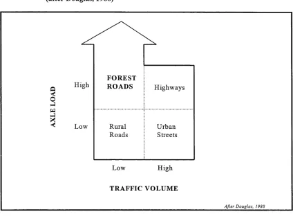
Figure 1.1 Comparisonof Forest Road Characteristicswith Thoseof Other Road Types
(after Douglas, 1988)... 3
Figure 1.2 Locality Mapof Study Areas - South Eastern Australia... 8
Figure 2.1 Relationshipbetween Road Construction/Maintenance Costand Road User Cost ... 11
Figure 2.2 Exampleof Ruttingona Forest Road (Bago State Forest, 19/5/98)... 21
Figure 2.3 Exampleof Road Numbering Methodproposedby Stewart Scott Inc., (after Stewart Scott In c., 1995)...31
Figure 3.1 Illustrationofdifferentclassesofroadfeature... 61
Figure 3.2 Sokkia Field GPS Unit Componentryand Orderof Assembly (SOKKIA, 1996)...65
Figure 3.3 Gridded Map Usedin Manual Data Collection Method 1... 69
Figure 3.4 Exampleof Data Collection Strip Map (Manual Data Collection Method 2 )...70
Figure 3.5 Exampleof Data Recording Form... 71
Figure 3.6 Pound Creek Study Area (Blomley's/Bowers Section), Bago State Fo r e s t... 74
Figure 3.7 FRMS Operational Flow Chart...78
Figure 3.8 FRMS Structure Withinthe ArcView GIS... 80
Figure 3.9 Exampleof Data Storedin Roads Theme Ta b l e...81
Figure 3.10 Feature Type Theme Table Showing Relevant Attributes - Crossings (Pound Creek Area, Bago State Forest) ...84
Figure 3.11 The Forest Road Management Systemat Completionof Data Add ition... 86
Figure 3.12 Exampleofa Strip Map Road Segment Condition Report (thenumberattheend OF EACH ROAD FEATURE DESCRIPTION IS THE DISTANCE OF THE FEATURE ALONG THE ROAD SEGMENT)... ...87
Figure 3.13 Reassessment Formdesignedin Microsoft Access® ... 88
Figure 3.14 Flowchart Illustratingthe Procedurefor Updating Asset Condition Information... S9 Figure 3.15 Flowchart Illustratingthe Procedurefor Updating Defect Information... 90
Figure 4.1 GPS aerialandmagneticmountonlogtruckro o f... 96
Figure 4.2 Comparisonof 2 daysdatashowingdifferenceinthenumberofpointscollected. Datarecorded 9th & 10th September, 1997. Princes Highwayand Poddy Creek Forest Road, East Gippsland, Victoria... 97
Figure 4.3 Non-differentiallyprocesseddatarecorded 13/9/97. Princes Highwayand Goolengook Road, East Gippsland, Victoria...98
Figure 4.4 Non-differentiallyprocesseddatarecordedon Goolengook Forest Road, East Gippsland, Victoria, 13/9/97... 99
Figure 4.5 Exampleof Log Truck Travel Time Map Query... 106
Figure 5.1 Basic Query Modulewithinthe Forest Road Management System...111
Figure 5.2 Close-upof Query Module Display...111
Figure 5.3 Exampleofa Photolog... 113
Figure 5.4 Projected Log Truck Loadsfor One Rotation - Pound Creek Area, Bago State Forest ... 117
Figure 5.5 Illustrationof B-double Log Truckre-routinganalysis... 119
Figure 5.6 ArcView GIS Screendumpshowingresultsofadrainagespacinganalysis...122
Figure 5.7 Selectedcrossingsgreaterthan 30mfromareliefdrain - Pound Creekarea .. 124
Figure 5.8 Exampleof Environmental Risk Evaluation - Stream Power Index... 125
LIST OF ABBREVIATIONS
ADT - Average Daily Traffic
CTI - Central Tyre Inflation
DEM - Digital Elevation Model
DNRE - Department of Natural Resources and Environment
FRMS - Forest Road Management System
EPA - Environmental Protection Authority (New South Wales)
GIS - Geographical Information System
GPS - Global Positioning System
ha - hectares
IRI - International Roughness Index (developed by World Bank)
km - kilometres m - metres
PCL - Pollution Control Licence
PMS - Pavement Management System
RMS - Road Management System
SFNSW - State Forests of New South Wales
Tonne.km’s - Tonne kilometres i.e. the equivalent of one tonne of wood travelling one kilometre
TQM - Total Quality Management
1
INTRODUCTION
Chapter Objectives:
1. Provide background and motives for the study
2. Outline the study procedure
1.1 Forest Roads
Roads are an essential element of any production forest. They provide access to the forest for
management operations, fire suppression, timber harvesting and haulage and, in some forests,
recreational activities. Construction and maintenance of roads account for a considerable part of the
cost of forestry operations. Together with transport costs, they account for around one third to one
half of the total cost of logs delivered to the mill door (Douglas, 1992). Forest roads are usually
unsealed, as they rarely warrant the high cost of bitumen sealing, but require regular maintenance to
prevent deterioration. Forest roads also impact heavily on log transport costs because they are
generally of a lower standard and cause trucks to travel more slowly, use more fuel and incur
greater mechanical wear. There is a tradeoff between road expenditure and transport efficiency.
Decreasing log transport cost often requires an increase in road construction/mamtenance costs.
Road construction and maintenance is usually paid for by the forest owner while costs associated
with log transport are often paid by the mill or contractor. Recent moves, especially in NSW,
towards mill door delivery, in both native and softwood plantation forest areas, will provide an
opportunity for more integrated management of roads and trucks thus capitalising on the potential
to minimise both haulage and roading costs.
Forestry is an intensive user of roads. As an example, State Forest of New South Wales manage
(this figure includes roads o f all standards) (P. W eeden1, pers comm., May 18th, 1998). This
equates to an average road network intensity o f 6.4 m/ha. Forest road network densities, however,
can be as intensive as 40 m/ha in some plantation forests (Tan, 1992;Morkel, 1994). Forestry, in
all Australian states, is pursuing a policy o f continued expansion of its softwood and eucalypt
plantation resource. Plantations are management intensive and require high density road networks,
so the number o f forest roads will continue to climb, making the bigger forestry organisations
amongst the largest road managers in their respective states.
A number o f factors distinguish forest roads from other road types (summarised in Figure 1.1).
Forests roads are often described as low volume, meaning that they receive small amounts o f traffic
(typically less than 100 vehicles per day). However, the average axle loads supported by forest
roads are generally much higher than those experienced by other low volume roads (e.g. rural shire
roads).
1.2 Forest Road Management Issues
A variety o f factors make the management of forest roads complex:
1. The need to minimise the impact of forest roads on the surrounding environment, especially
stream water quality, has become an important priority for forest managers.
2. The standard of forests roads, and therefore the cost, is rising to meet the requirements of
log haulage contractors who are using heavier trucks
3. There is often a need to meet the demands o f the public who require access to forests for
recreational pursuits. This need sometimes conflicts with the main aim o f providing access
for log haulage
Figure 1.1 Comparison of Forest Road Characteristics with Those of Other Road Types (after Douglas, 1988)
FOREST
ROADS Highways
Rural Roads
Urban Streets
TRAFFIC VOLUME
After Douglas, I9SS
Forested catchments are often the source of high quality water for community supply. Forest
operations are a primary cause of sediment production. Therefore, the need to harvest timber from
within these catchments conflicts with water production requirements. Researchers have identified
that the bulk of sediment produced by forest operations originates from roads (Haydone/ al., 1991;
Elliot et al., 1995), and this issue is receiving the attention of monitoring bodies.
The rising cost of running log trucks has seen a move towards bigger trucks, capable of carting
heavier payloads, in order to increase efficiency. For example, a B-Triple log j inker has recently
been introduced in Victoria, Australia. The jinker is 31.6 metres in length and can carry 20 tons
more than a B-double trailer, which has a payload of approximately 40 tons (Forest Logger and
[image:15.529.65.489.114.436.2]loadings and the wide curve radius they require. Therefore, if log trucks of this size become more
common, major road upgrades will be required in many forests.
Some emerging log truck technology may benefit the forest road manager. Automatic Slip
Regulation (ASR) and tridem drives allow log trucks to operate on increased road gradients (Amlin,
1998). Central Tyre Inflation (CTI), already being used by some log haulage contractors in
Australia, allows drivers to reduce or increase the pressures of a truck’s tyres during operation.
This ability has direct benefits for the haulage contractor as it provides a better ride, decreased
mechanical wear and greater traction on unsealed roads. Lower tyre pressures are also less
damaging to the pavement of forest roads (Bradley, 1996). Systematic road management is
required, before the benefits of these new technologies can be properly assessed.
1.3 Forest Road Management Systems
Successful management of assets and infrastructure requires a sound knowledge of condition. This
premise underlies the road management system concept, with the road management system
combining inventories of road network components and descriptions of their condition.
Computerised road management systems have been developed over the last 20 years and are now in
common use by shires and highway managers, largely for pavement management. They can then
make information available to the road manager for use in deciding management priorities such as
maintenance or upgrading.
A number of road management systems are already in existence but these are generally aimed at the
needs of shires and highway managers. Their primary focus is sealed pavement maintenance.
Forest roads have very different characteristics to shire roads and highways. Forest road managers
have a need to meet strict environmental compliance rules. The suite of road management systems
Rummer et al. (1997) observe that there is a requirement by forest managers for practical, cost
effective tools to manipulate the forest and achieve desired ecological conditions. They state that
developing management tools for ecosystem management is the new challenge for forest
operations. A computer based forest road management system that addresses both environmental
and commercial objectives is an example of such a tool.
The practicality and utility of road management systems is increasing rapidly due to recent
advances in Geographical Information System (GIS) and Global Positioning System (GPS)
technology. GIS’s provide an excellent database for storing road information. They allow data to
be viewed at various scales, from the individual road section up to the regional network. Modem
GIS’s allow sophisticated querying based on the spatial relationship between data. GPS is being
used to dramatically increase the efficiency of spatial data collection. Some types of GPS are
integrated with electronic data loggers that allow the user to enter information about the point of
interest at the same time as the GPS measures and records its location. Information recorded in this
way can then be electronically transferred and stored within a GIS for display and analysis.
One benefit of a Forest Road Management System (FRMS) would be to provide support in
environmental performance objectives. It could do this by providing a platform to systematically
monitor key road features (such as drainage and crossing structures) and report their condition and
to identify road sections that present high environmental risk. In the longer term, a FRMS has the
potential to provide major benefit in managing transport, planning road upgrades and determining
maintenance schedules. Detailed road condition information will be available for harvest managers
to use in assessing the optimum haulage routes for logging operations. Impediments to haulage
operations (e.g. unsound bridge decking) can be identified and repaired well in advance. Records
of the locations of loading bays, truck turnarounds and landings would be stored within the FRMS
1.4 Study Approach
The goal of this project was to develop and test a pilot-scale FRMS designed to meet the specific
requirements of Australian forestry. These requirements are to maintain and demonstrate
environmental compliance as well as to support road and transport planning. Development and
testing of the system involved:
1. Defining what road data need to be collected and rules for classification
2. Designing data collection procedures
3. Developing the FRMS as extension to the widely used Arc View™ GIS
4. Investigating the addition of road user cost to the FRMS
5. Demonstrating potential applications of the FRMS
6. Designing methods to support road condition auditing and updating FRMS
7. Evaluating the likely cost of implementing FRMS
Systematic asset management requires collection of data in the field, classifying, recording and
structuring data in a way that allows efficient analysis. Methods for collecting data for the FRMS
were designed and trialled. Conventions for systematically classifying and describing road
segments, assets and defects were then developed.
Forestry organisations are realising that gams in efficiency are possible through controlling
harvesting and transport operations. This presents the opportunity to better integrate roadmg and
transport operations. For this to occur, road managers need information on how their roads are
influencing the operation of log trucks. This influence is best measured through log truck travel
times and these data need to be stored and made available to managers in the same context as road
maintenance and construction costs. The collection and addition of these data to the FRMS was
The FRMS was developed within the ArcView GIS (ESRI, 1996) framework around datasets
collected in the field. Many of its operations use the functions provided by this GIS program.
Customisation of the GIS allowed several management related enquiry functions to be developed as
examples. Their use in supporting forest road management was then demonstrated.
Forest roads should be inspected on a regular basis and the FRMS was designed to support and
improve the inspection process. This is one of its major benefits. The FRMS was used to produce
condition reports and assessment sheets to assist in regular road assessment. These were trialled in
the field to relocate features in the field and to note any changes in their condition.
Collection of road data for an extensive forest management area will be a large task. Many road
management systems are abandoned at the implementation phase because collecting the initial
dataset is too costly and time consuming. These costs are a function of the collection efficiency and
the numbers of features requiring mapping. A study was made to determine the likely FRMS data
collection cost for a large plantation forest.
1.5 Data Collection Areas
The data set around which the pilot-scale FRMS was developed was collected from Bago State
Forest near Tumbarumba in Southern NSW. Data for the implementation cost study were collected
in Bago and in the adjacent Green Hills State Forest (both part of State Forests of NSW’s Hume
Region). Log truck travel times were collected from the East Gippsland Region of Northern
Figure 1.2 Locality Map of Study Areas - South Eastern Australia
1.6 Objectivesand Outline
The objectives of this research were twofold:
1. To develop a pilot-scale forest road and transport management system, including
development of efficient data collection techniques, that operates in a GIS database
allowing querying and analysis based on spatial relationships
2. To estimate the time and money costs of implementing such a system for a large forest
[image:20.529.63.478.78.395.2]The thesis outline is as follows:
Chapter 1
Chapter 2
Chapter 3
Chapter 4
Chapter 5
Chapter 6
Chapter 7
Introduction of study describing its justification and scope
Review of literature to identify the needs of forest road managers,
identify components of road and pavement management systems and
review existing systems
Design and trial of data collection methods suitable for capturing road
segment and road feature information; Development of a road
management system within GIS environment
Investigation of the addition of road user cost (in the form of log truck
travel times) to the system’s database
Demonstration of proof-of-concept by using the system to perform a
range of functions
Investigation of the feasibility of implementing such a system
Discussion of further development of the FRMS and possibilities for
2 FOREST ROAD MANAGEMENT
Chapter Objectives:
• Describe wliat management o f forest roads involves and discuss issues and factors
affecting it
• Discuss the concept o f Road Management Systems that have been developed for use by
Highway and shire road managers
• Review the application o f Road Management Systems to forestry
2.1 Introduction
Forestry activities require a suitable road network. Roads, in turn, require management. Proper
management of forest roads requires knowledge of the condition of the road network and its
associated structures and an understanding of how effectively it is serving the needs of the road
users. This chapter reviews forest road management and the concept of road management
systems, and their applicability to forestry, is discussed.
2.2 Forest Road Management
The major objective of this research project was to develop a forest road management system for
use in Australia and, in particular, New South Wales. Sound forest road management aims to
minimise the overall cost of transporting logs to the mill. This involves striking a balance
between providing a certain level of access for the forest user (referred to as serviceability) while
keeping construction and maintenance costs as low as possible. This problem is illustrated in
Figure 2.1 Relationship between Road Construction/Maintenance Cost and Road User Cost
R e l a t i o n s h i p b e t w e e n R o a d C o n s t r u c t i o n /
M a i n t e n a n c e C o s t a n d R o a d U s e r C o s t
\ O p t i m u m
T o t a l C o s t
$
T r a n s p o r t C o s t R o a d B u i l d i n g / M a i n t e n a n c e C o s t
R o a d S t a n d a r d
This aim is becoming more complex in areas such as NSW due to the need to meet strict
environmental regulations. The environmental risk posed by unsealed forest roads has been
recognised since at least 1917 (Reid and Dunne, 1984). Until recently however, water users
downstream of the forest met the cost of water body sedimentation. The responsibility of
ensuring that the amount of sediment that reaches water bodies is minimised now rests with
forest owners. Their success in doing so is monitored by various agencies. In New South Wales,
the monitoring agency is the Environmental Protection Authority (EPA). The Environmental
Protection Authority issues State Forests of New South Wales a ‘Pollution Control Licence’
(PCL). Eleavy fines punish breaches of the conditions attached to the PCL.
Historically, log haulage costs in Australia have been directly accrued by mills rather than forest
owner selling logs at the mill door. Therefore, forest owners will have increasing interest in
minimising all costs associated with roads.
Poor management of forest roads can result in three costs: the cost associated with environmental
degradation; increased cost to the user and high maintenance cost. Sound forest management can
reduce the environmental impact of roads through a number of means. Field staff and contractors
working in the forest should understand the causes of erosion and sedimentation, as well as
techniques for their mitigation. New mitigation techniques should be developed and trialled.
Roads constructed before such tight environmental requirements existed must now be upgraded
to meet these requirements. The next step for forest management is to implement systematic
monitoring of the functionality of road drainage structures and the early detection of erosion
risks.
Separated management of forest roads and transport has often meant that the role of forest
owners m ensuring road serviceability was often limited to maintaining regular contact with
haulage contractors and reacting to problems as they occurred. The introduction of mill door log
sales may see the potential for lower haulage rates to be negotiated in exchange for guarantees of
increased road network serviceability.
High maintenance costs sometimes result from poor construction practices, which are beyond the
scope of this study (which is aimed at managing the existing asset). In some cases, the remedy
may be relatively cheap (eg. install extra drainage) but in other cases, upgrading the road
alignment may be the only solution. Most forest road networks will have segments that fail
periodically, such as during wetter winter months. A common response to such failures is the
‘quick fix’. A simple example of this may be dumping several loads of gravel on a troublesome
spot every winter. However, at some point, the cost of this annual patch gravelling operation is
and recompact road surface). Sound management is required to determine whether the ‘quick
fix’ or the ‘permanent fix’ is ultimately the cheaper option.
Successful forest road management requires an understanding of the environmental impacts of
roads and knowledge of the factors influencing the road user. The environmental impacts of
forest roads are described and discussed in Section 2.3. Factors affecting serviceability levels, or
road user costs, are addressed in Section 2.4. The importance of road drainage in maintaining
serviceability while minimising environmental impact is discussed in Section 2.5.
2.3 Environmental Impacts
The heavy environmental cost associated with unsealed forest roads is widely acknowledged.
The primary cost is the amount of sediment, removed from roads by rainfall runoff, that
ultimately enters creeks and streams. Sedimentation of creeks and streams has a detrimental
effect on aquatic life; (Cambell andDoeg, 1989) and decreases the quality of water for end users
(Wallis and McMahon, 1994; Rothwell, 1983; Beschta, 1978). Ensuring that their roads are
environmentally compliant has become a major concern for forest managers world wide (FAO,
1996). This level of concern is highlighted in a study performed by Egan et al. (1996). They
conducted a survey in which 10 resource professionals (from the USA) with extensive experience
in forest road management were asked to comment on a range of management issues. Water and
drainage management was identified as being the major consideration for forest road engineering
and as forming the biggest challenge to forest road construction and maintenance.
The surfaces of forest roads generally have low permeability, with infiltration rates as low as 1 to
4 mm/hr (Mockler and Croke, 1998). This results in runoff occurring even after relatively small
There are several important sediment sources associated with forest road construction and use:
1. Movement of soil and debris directly into permanent water courses during
construction/maintenance of roads, smg tracks and landings
2. Movement of soil and debris placed near permanent water-courses or temporary water
courses
3. Surface erosion from road and landing surfaces and table drains
4. Surface erosion of fill material
5. Mass movement of batters
6. Mass movement of up-slope materials caused by reactivating old erosion features
7. Failure due to removal of batter slope toe (Wallis and McMahon, 1994).
Much research had been dedicated to measuring the amount of sedimentation produced by forest
roads (Burroughs Jr. et al., 1983; Reid and Dunne, 1984; Haydon et al., 1991; Brown, 1994).
Efforts have also been made to model the sedimentation process in order to predict future
production levels (Leaf, 1974; Elliot et al., 1994; Elliot et al., 1995; Macdonald et al., 1997;
Anderson and Macdonald, 1998). Other research has been directed at developing and evaluating
structures (Eriksson, 1983) and techniques (Rothwell, 1983; Swift Jr., 1984; Grace III et al.,
1998) that reduce the environmental impact of forest roads.
The level of sediment production from unsealed roads varies with slope, soil type and traffic
levels. Researchers have reported a large range of production rates (see Table 2.1), varying from
0.2 tonnes/hectare/year up to 1250 tonnes/hectare/year (Haydon et al., 1991). The lower rates
were reported by Fahey and Coker (1989) in Wallis and McMahon (1994) on predominantly
granitic and schist soil and rock types. They estimated that these levels would increase to 1 to 2
tonnes/ha/yr if the roads were used, but acknowledged that these figures were very low in
Table 2.1 Forest Road Sediment Production Rates - Literature Comparison
SOURCE SEDIMENTATION
RATE
(tonnes/km2/yr)
COMMENTS
M o s l e y in M c M a h o n 7 1 0 S W N e l s o n , N Z
F a h e y & C o k e r ( 1 9 8 9 )
M c M a h o n ( 1 9 9 4 )
in 3 7 S W N e l s o n , N Z - G r a n i t e s o il
F a h e y & C o k e r ( 1 9 8 9 )
M c M a h o n
i n 3 2 0 S W N e l s o n , N Z - G r a n i t e s o il
d u r i n g h a r v e s t o p e r a t i o n s
F a h e y & C o k e r ( 1 9 8 9 )
M c M a h o n ( 1 9 9 4 )
in 6 7 S W N e l s o n , N Z - S c h i s t s o il
F a h e y & C o k e r ( 1 9 8 9 )
M c M a h o n ( 1 9 9 4 )
in 2 0 0 S W N e l s o n , N Z - S c h i s t s o il d u r i n g
h a r v e s t o p e r a t i o n s
F a h e y & C o k e r ( 1 9 9 2 )
M c M a h o n ( 1 9 9 4 )
in 6 2 M a r l b o r o u g h S o u n d s , N Z
F a h e y & C o k e r ( 1 9 9 2 )
M c M a h o n ( 1 9 9 4 )
in 1 0 0 M a r l b o r o u g h S o u n d s , N Z
O 'L o u g h l i n in M c M a h o n ( 1 9 9 4 ) 1 7 6 W e s t l a n d , N Z
H a y d o n e t a l. ( 1 9 9 1 ) 3 0 M e l b o u r n e ( V i c t o r i a ) w a t e r
c a t c h m e n t a r e a
R e i d & D u n n e ( 1 9 8 4 ) 5 0 0 H e a v i l y u s e d r o a d , W a s h i n g t o n
S t a t e , U S A
R e i d & D u n n e ( 1 9 8 4 ) 6 6 R o a d t e m p o r a r i l y in n o n u s e ,
W a s h i n g t o n S t a t e , U S A
R e i d & D u n n e ( 1 9 8 4 ) 4 2 M o d e r a t e l y u s e d r o a d , W a s h i n g t o n
S t a t e , U S A
R e i d & D u n n e ( 1 9 8 4 ) 3 .8 L i g h t l y u s e d r o a d , W a s h i n g t o n
S t a t e , U S A
R e i d & D u n n e ( 1 9 8 4 ) 2 P a v e d r o a d , W a s h i n g t o n S ta te ,
U S A
R e id & D u n n e ( 1 9 8 4 ) 0 .5 1 A b a n d o n e d r o a d , W a s h i n g t o n S t a t e ,
U S A
B e s c h t a ( 1 9 7 8 ) 9 8 A v e r a g e a c r o s s s t u d y w a t e r s h e d s ,
of traffic density on sediment yields and report a production rate of 1250 tonnes/ha/year for roads
receiving a minimum of 4 loaded trucks per day. They found sediment production dropped
significantly, to 9 tonnes/ha/year, on roads that were only used occasionally by light vehicles.
One mitigation measure is to ensure that the road is drained at intervals that are frequent enough
to prevent runoff gaining enough velocity to cause erosion. The ideal drainage interval must
counter two effects. Firstly, the interval must prevent erosion of the road surface or table dram
(State Forests of NSW, 1996c). Secondly, the interval must be such that discharge from the
structure’s outlet doesn’t form channellised flow from the structures outlet to a drainage feature
(creek or stream) (Montgomery, 1994; Wemple et al., 1996; Bowling et al., 1996, Mockler,
1998; Mockler and Croke, 1998).
2.4 Maintaining Serviceability
Forest roads have two functions. The major function is to provide access to the forest for
management and silvicultural purposes and for transporting forest products (Morkel, 1994).
Their minor function is to act as firebreaks. The level of access provided by forest roads is
referred to as serviceability. A road with zero serviceability is impassable. Poor forest road
management results in a decrease in the level of serviceability. Road serviceability is reflected in
six ways:
1. Driver comfort
2. Safety
3. Fuel consumption
4. Mechanical wear
5. Driver fatigue
Any characteristic of a road that prevents transport from being 100% efficient is known as a
‘resistance factor’ (Douglas, 1988). Resistance factors are classified either as direct, present in a
road from its construction, or indirect, which accumulate due to lack of road maintenance. The
impacts of these resistance factors are described below.
2.4.1 Direct Resistance Factors
Direct resistance factors are present in the road as soon as it is built. Performing a major upgrade
on the road itself is the only way of reducing the effect that these factors have on increasing
transport cost. These factors include road pavement flexibility, vertical alignment, horizontal
alignment and road profile.
Forest roads exhibit flexibility, to varying degrees, under the downward pressure exerted by
vehicle tyres. This flexibility creates a depression under each tyre that moves continuously with
the wheels. The depression creates a resistance to the travel of the vehicle and is referred to as
rolling resistance. Rolling resistance affects fuel consumption, mechanical wear and travel speed
(Douglas, 1988).
Grade, or vertical alignment, is widely acknowledged to have a significant effect on log truck
travel speed and hence, log transport cost (Byme et al., 1960; Beath, 1976; Jackson and Sessions,
1987; Winter, 1995). Road gradient affects travel speed, fuel consumption and mechanical wear.
The horizontal alignment, or ‘twistiness’, of a road has a significant impact on travel speeds. The
tighter a comer is, the slower the vehicle must travel to negotiate it. Comer tightness is referred
to in terms of curve radius. The twistmess of a section of road is established by measuring the
Massey-Reed (1978) in the formulation of a log truck travel time prediction model for forest roads in
New South Wales.
As a truck negotiates a comer, centrifugal forces tend to move the truck to the outside of the
corner. The power expended by the truck in countering this tendency, in order to stay on the
road, is known as centrifugal resistance (Morkel, 1994). Centrifugal resistance affects truck
travel speed and for this reason, comers of high standard roads are tilted or bermed (known as
super-elevation). Super-elevated comers reduce the amount of centrifugal resistance to the truck
and allow it to comer at a higher speed.
2.4.2 Indirect Resistance Factors
Indirect resistance factors are aspects of the road that can affect transport efficiency but change
over time or with level of maintenance. Indirect resistance factors include surface condition,
sight distance and road width.
Surface condition has a major influence on transport cost. Lui and O’Reilly (1987) in Morkel
(1994) developed simulation models showing that, by grading an unsealed road, the achievable
speed of a loaded log truck increased by 90% and fuel consumption decreased by 11.6%. For
unloaded log trucks, they determined that achievable speed increased by 60% and that fuel
consumption decreased by 60%. Liautaud and Faiz (1994) estimate that neglect of maintenance
of unsealed road surfaces can result in vehicle operating costs doubling or even tripling.
Sight distance, the length of road visible to the driver at a given point, affects travel speed and
safety (Yamamoto, 1981). Vegetation regularly encroaches onto the road right-of-way, reducing
sight distance, so slashmg/clearing of the verges of major roads should be a routine maintenance
affected vehicle speed. A high correlation was established between vehicle speed and sight
distance. However, the limiting effects of grade may override those of sight distance (Jackson
and Sessions, 1987). McCormack (1992) considered that the limiting factor on log truck speed
and engine power for road sections with poor sight distance was the driver’s willingness to avoid
a collision.
Narrow roads inherently have poor sight distance, affecting travel speed (Douglas, 1988). Travel
speed can be further reduced when vehicles meet, though this is usually catered for by the
provision of passing bays (Byrne et al., 1960).
2.4.3 Interaction between road and vehicle
The interaction between road and vehicle is complex. Road roughness generates dynamic forces
in the vehicle which, in turn, exacerbate the roughness of the road (Mamlouk, 1997).
Forest roads are characterised by low traffic volumes but high average axle loads. This means
that a Typical interaction’ between forest road and vehicle results in a greater impact to the forest
road than for other road types. Sedlak (1988) illustrates this point by noting that one 20 ton truck
with a single axle load of 14 tons may cause stresses on the pavement equal to that of 12 trucks
with single axle loads of 8.2 tons. However, the pavement stresses applied by the 8.2 ton single
axle truck are equivalent to those generated by 5,000 light vehicles. Martin et al. (1998)
evaluated the pavement damage caused by a 6 axle log truck (40 ton gross vehicle weight, 27 ton
payload). They noted that this type of truck represented 3 times the load of a standard axle (8.2
tons) and determined that raising the payload by 10% would increase the potential road pavement
damage by 20%. Their conclusion was that the serviceability of forest roads is significantly
compromised considerably whenever truck configurations with greater axle loadings are
introduced to forest operations.
Vehicle speed also affects pavement condition. This is especially true of gravel surfaced roads.
High cornering speeds result in gravel particles being swept off the road (Sedlak, 1988). The
result is the ‘windrows’ of gravel commonly seen on forest roads. These gravel windrows then
exacerbate pavement deterioration by preventing water from leaving the road surface. They also
represent a hazard to traffic.
2.5 Influence of road drainage on Environmental Impact and Road
Serviceability
It is clear that a functioning road drainage system is necessary to maintain a high level of service
as well as to minimise the impact of forest roads on the environment. Poor road drainage causes
increased environmental degradation and maintenance costs and reduces road serviceability. The
majority of forest road problems are caused by poor drainage (Morkel, 1994). Martin et al.
(1998) explored the relationship between road drainage and surface condition. They found that
pavement quality was largely dependent upon drainage conditions and that number of potholes
was strongly influenced by level of road drainage.
In some circumstances, road serviceability level is also linked to environmental degradation. For
example, water can pool on the surface of poorly formed unsealed roads. When vehicles pass
through the standing water, rutting can occur (Figure 2.2). The rutted surface provides an
obstacle to further road use and increases the potential for sediment to be produced from the road
Figure 2.2 Example of Rutting on a Forest Road (Bago State Forest, 19/5/98)
Burroughs Jr. and King (1989) describe a comparison between the sediment production o f a
smooth forest road with that o f a road that had been rutted by the passage o f a heavy logging
truck. Simulated rainfall experiments were used to show that sediment production from the
rutted road surface was 2.08 times greater than the amount produced by the smooth surface.
Three types o f road drainage are required: drainage to keep the road out o f water; drainage to
keep water out o f the road and drainage to get water away from the road (Hoffman (1993) in
Morkel, 1994).
Ensuring that the road is kept out o f water is mainly a planning or construction issue. Obviously
roads should be routed away from swampy areas, but sometimes construction must traverse areas
such as bogs and springs. These areas require subsoil drainage, which allows movement o f water
beneath the road subgrade without penetrating it. In flat or low-lying areas, roads are usually
If water is allowed to reach the subgrade of a road, the integrity of the road itself is lost. This
means that the road will be unable to support traffic (especially heavy vehicles). Common
problem areas are where roads traverse or pass springs and swampy areas.
Water penetrating the road surface can cause the pavement to breakup, producing potholing and
cracking. Proper grading and compaction techniques aim to seal the road surface so that water
tends to run off it rather than penetrate it. A good forest road is constructed with a slight fall
(crossfall) to its surface to prevent water pooling. In flatter areas, roads generally have a
crowned profile in which the surface of the road slopes away form the road centre at each side.
Side cut roads should have either infall to direct water to culvert inlets, or outfall to turn water
onto the fill batter.
Erosion potential of runoff increases in proportion to its volume and velocity (State Forests of
NSW, 1996c). Therefore, major problems result if the road surface and table drams aren’t
drained at regular intervals. The spacing between drainage points becomes more critical as the
gradient of the road increases. Water flowing across a road surface with high velocity causes
rilling and gullying which increases surface roughness dramatically. In some circumstances, it
may make roads impassable.
A fully functional drainage structure extends to the area onto which the runoff is released. This
area must be stable and runoff velocity should be minimised. If the outlet area is a batter slope,
armoured structures (known as dropdowns) should be used to direct the flow down the batter
face. Roads should also be drained prior to crossings to prevent turbid water entering the
drainage feature (EPA, 1998).
Effective road drainage plays an important role in maintaining levels of forest access and
sufficient drainage and then systematic checking and maintenance of drainage structures. The
adoption of such a strategy is an example of 'Best Practice’. This concept, and its application to
forest road operations, is described in the next section.
2.6 Best Practiceand Total Quality Management
The forest industry (like other sectors) is recognising the need to demonstrate to customers and
the public that its operations are conducted thoroughly, using the most appropriate methods. This
is known as ‘best practice’ and they have been devised for a variety of forestry operations with
more being initiated. Best practice is often formulated via a process called ‘Total Quality
Management’.
Total Quality Management (TQM) is a concept that is being used by many businesses to increase
the efficiency of common operations and procedures. TQM is being applied to the forest
industry in a variety of ways. For example, State Forests of New South Wales are pursuing TQM
objectives for tasks such as harvest planning in softwood plantations, administrative processes,
land purchase for eucalypt plantation and waste disposal (H. W all1, pers. comm, 4th August
1998).
The aim of TQM is to ensure that the output or result of a process is at an optimal level, or at
least within a set of predefined, acceptable limits. Tarte (1992) provides an example that is of
direct relevance to road managers:
“Consider an asphalt road pavement. The optimum thickness of the asphalt
pavement may be determined and will depend on the underlying soil conditions,
the amount and type of traffic, the economic design life of the road and the type of
asphalt to be used. If the pavement is thicker than the optimum design then clearly
we are paying for too much expensive asphalt. If the pavement is thinner than the
optimum design we will pay for increased and earlier maintenance. Each of these
types of cost increases as we move away from the target or optimum thickness
values.”
TQM works by minimising ‘Cost of Quality’ which is comprised of three aggregate costs (Tarte,
1992):
1. ‘Cost of Failure’ - Eg. cost associated with log trucks hauling on a sub- standard road
2. ‘Cost of Appraisal’ - Eg. cost to collect information on the impact of having log trucks
hauling on a sub- standard road
3. ‘Cost of prevention’ - Eg. cost of building a higher standard road.
Road management can benefit from using a TQM approach. Before costs of failure and
prevention can be determined for a road network, its current condition must be ascertained.
Priorities for the reduction of these costs can then be set. The need for road managers to set these
priorities saw the development of specialised management systems that incorporate low appraisal
costs. These management systems are described in Section 2.7.
2.7 Road Management Systems
Systems have been developed to help organisations manage their roads. These have been termed
Road or Pavement Management Systems. Pavement Management Systems, as their name
suggests, focus specifically on the road pavement. Road management systems include road
here to refer to both types of system. All systems address at least one component of
serviceability cost. The problem for forest road managers is that few systems, even those
developed specifically for forestry, address the environmental costs as well. A road management
system can be defined as any system that increases the ability of an organisation to manage the
network of roads under their administration.
Road maintenance is an expensive, ongoing task and the major application for most road
management systems lies in prioritising maintenance operations. Various systems use a
combination of current road condition information and road use data to assign priorities. The
road manager then matches the allocated budget to the highest priority jobs (McCullough, 1985;
Visser and Curtayne, 1987; Ayers, 1987; Hallet and Jacobsen, 1994).
The use of current road condition information can be extended to the prediction of future road
condition (Ullidtz, 1985). Systems that perform this function utilise road deterioration models
and use assumptions made about future traffic volumes (Haas et al., 1994).
Road management systems can also have an historical database application. Hallet and Jacobsen
(1994) suggest the addition of maintenance details and expenditure information to a system in
order to more accurately predict the cost of future maintenance operations.
2.7.1 Applying Road Management Systems to Forestry
Douglas and McCormack (1995) identified the need for forest road managers to adopt the
principles used in road management systems. They observed that the emphasis of forest roadmg
activities is shifting from the construction of new roads to the maintenance of existing ones. The
highway (for which most road management systems are designed) and forest road pavements and
then modify the practices used in road management systems to accommodate them.
The majority of road management systems have been designed for sealed roads, particularly
highways. Australian forest road networks, however, are characterised by being mostly unsealed.
For example, State Forests of New South Wales manage less than 200km of sealed road
compared with approximately 25,000 km of unsealed road (P. Weeden 2, pers. comm., 18,h May
1998).
The amount of justifiable expenditure on the management of an asset is directly proportional to
the value of that asset. The level of investment, per average kilometre, made in forest roads is
vastly less than that made for highways. Therefore, the likelihood of a forest agency deciding to
invest heavily in a road management system is low. As well as generally being ot low standard,
forest roads typically receive low traffic volumes hence any road management system adopted by
a forestry organisation will have to be low in cost since there isn’t the traffic volume against
which its cost can be amortised (Douglas and McCormack, 1995).
Table 2.2 provides a general comparison of the differences in styles of management adopted by
road management agencies in Australia. The comparison suggests that torest management
agencies (who are often amongst the largest road managers) are the least likely to adopt
sophisticated road management systems.
Table 2.2 Differences in road management approach in Australia - Forestry, Shires and Highway Authorities
FEATURE FOREST ROADS SHIRE ROADS HIGHWAYS
Pavement Generally Unsealed Majority Sealed Virtually all Sealed
Management Focus of Forest Management Infrastructure Highway
Responsible Agency Management Management
Traffic Characteristics Low Volume, High Medium Volume, High Volume, low
average axle loading Moderate average
axle loading
average axle loading
Professional Training Usually Forestry
trained, reliance on
staff with experience
Engineers Engineers
Environmental Risk High Moderate Low
(after roads are built)
The task of developing a system for the management of forest roads is being undertaken in
several countries. Many of these systems are designed to perform complex functions such as
prediction of road life or selection of appropriate truck configurations for specified conditions
(Provencher, 1997). These systems have been mainly designed for forest companies in North
America and Canada that operate in highly industrialised forests. The immediate needs of the
Australian forest road manager are more likely to be to know “what’s out there?” and “what
condition is it in?”. Once this information is at the manager’s fingertips, a higher level of
2.7.2 Levels of Operation
Road Management Systems usually operate on at least two levels, network and project:
• Network - Road Management System functions at this level are confined to
prioritising / scheduling roadwork and budget management
• Project - Operations at a project level deal with individual sections within the
network. Eg. Selecting maintenance alternatives
Haas et al. (1994) differentiate between road management systems that operate at two levels and
those that operate at three. Three level systems have an extra level that concerns decisions
involving a group of projects and so fall between the scope of network and project levels. A
forest road management system should be designed to operate at three levels in order to handle
the wide variety of forest road and forest road user types. For example, the forest road manager
may wish to consider the network of fire trails as a distinct entity within the whole network.
2.7.3 Road Section Definition and Referencing
For the purpose of road management systems, the road network should be divided into sections.
The road sections should then be referenced in a logical way. Section definition can be either by
uniform characteristics or by fixed lengths. The use of the fixed length approach is simple as
data is collected at each milepost. However, changes in road standard and other features of
interest are more likely to occur between mileposts.
Section definition through the use of uniform characteristics means that section boundaries are
selected to correspond with features such as maintenance district boundaries, change in pavement
In the forestry environment, it is preferable to define sections as links between intersections as
they are generally built to a consistent standard along the entire length of each link. This also
makes section definition via the use of a GIS straightforward. Points of significant change in
road standard not occurring at an intersection are relatively rare.
Haas et al. (1994) describe four systems for referencing road links:
1. Route Milestone System: Each route is assigned a unique identifier and the starting point
of the route is defined. Mileposts are then sequentially numbered, along the route,
commencing at the starting point
2. Node-Link Method: Key points within the road network are defined as nodes and the
sections between these points are defined as links. Nodes usually equate to intersections,
boundaries or abrupt changes in road standard (especially pavement change)
3. Branch - Section Method: Developed for use in airfield pavement management. Has
been extended for use in road management in which individual roads or routes are
defined as branches and homogeneous portions of these roads or routes are defined as
sections.
4. GIS: The major disadvantage with the use of a GIS supported road management system
is that the initial definition of the road network can be time-consuming and expensive.
However, advantages include the ability to produce maps showing selected road features
and the easy addition of new features to the database.
Diggens et al. (1994) describe a linear referencing method used in the Road Information