Modelling Groundwater-River Interactions for
Assessing Water Allocation Options
Karen Marie-Jeanne Ivkovi
ć
September 2006
A thesis submitted for the degree of Doctor of Philosophy
I certify that this thesis does not incorporate without acknowledgment any material previously published. This work has not previously been submitted for a degree or diploma in any institution of higher education.
Karen Ivković
Acknowledgments
“They do not step into the same rivers. It is other, and still other waters that are flowing” - Heraclitus
It is said that the journey of a thousand miles begins with a single step. For me the first step was walking to the printer at my workplace and seeing information on scholarships (printed by somebody else) interspersed within my own documents. From that point onwards the possibilities of undertaking PhD studies grew in my mind and were further nurtured by my husband Damir, who has been unfailingly supportive throughout my PhD journey. Damir and my father, Douglas, both proofread and commented upon penultimate thesis drafts. I’d also like to thank my mother, Monique, family and friends for their encouragement over the years.
I am grateful to my supervisors Professor Tony Jakeman, Dr Rebecca Letcher, Dr Barry Croke and Dr Mirko Stauffacher for their guidance. I’d especially like to thank Rebecca Letcher for her direction in conceptualising the thesis story so that it had a highly relevant, original and interesting plot, for her assistance with the programming and usage of ICMS, for her consistently clear and strategic advice, and for her enthusiasm. I am particularly grateful to Barry Croke for having shared his insights into model conceptualisation processes and for assisting me with the use and application of numerous in-house models. Barry gave generously of his time in teaching me to program (and debug!) Fortran code. Ray Evans was one of my key advisors, and although he was not a supervisor, he gave as much guidance as if he had been a supervisor. I’d like to acknowledge the encouragement he provided.
I’d also like to acknowledge the stimulating learning environment of CRES and iCAM, as well as the great students and staff with whom I feel honoured to have studied. The inspiration to describe an aboriginal viewpoint of connected water resources came from a seminar given by Dr Deborah Bird Rose. I’d like to thank staff members Susan Cuddy, Adele Doust, Phil Greaves, Steve Leahy and Karl Nissen for their administrative and IT support, and particularly Susan Kelo of iCAM who provided heartfelt assistance in every way she could. A big thanks to Virginia Woodland from the Graduate Information Literacy Program for her help in formatting with MS Word. I’d like to thank Felix Andrews and Michael Kehoe for their assistance with model calibration, including more efficient ways to go about this task, and for allowing me the usage of some of their programs.
The progression of work presented in this thesis would not have been possible without the assistance of a large number of other professionals including:
Dr Noel Merrick from the University of Technology in Sydney who generously provided me with copies of his Namoi River catchment model reports and commented on my summaries of previous groundwater models developed for use in the catchment. Mike Williams, George Gates, Peter Sinclair, Alex Springall, Angela McCormack, Andrew Cutler, Anthony Newland, Lee Vitry, Robert Braaten, Catherine Barret, Craig McNeilage, David Outhet, Dawit Berhane, Gary Hampton, Gary Coady, Guy Lampert, Amalia Short, Ken Gillespie, Krish Illungkoo, Mark Mitchell, Peta Hansen, Richard Myers, Ross Beasley, Sriyani Manchanayake, Sue Powell and Tikiri Tennakoon from the New South Wales Department of Natural Resources provided me with access to their data and background reports/materials. I’d especially like to thank Guy Lampert and Amalia Short for taking the time to accompany me into the field, show me some key river geomorphologic features and provide me with critical feedback on my aquifer-river interactions mapping assessment.
Abstract
The interconnections between groundwater and river systems remain poorly understood in many catchments throughout the world, and yet they are fundamental to effectively managing water resources. Groundwater extraction from aquifers that are connected to river systems will reduce river flows, and this has implications for riverine ecosystem health, water security, aesthetic and cultural values, as well as water allocation and water management policies more generally. The decline in river flows as a consequence of groundwater extractions has the potential to threaten river basin industries and communities reliant on water resources.
In this thesis the connectivity between groundwater and river systems and the impact that groundwater extractions have on river flows were studied in one of Australia’s most developed irrigation areas, the Namoi River catchment in New South Wales.
Gauged river reaches in the Namoi River catchment were characterised according to three levels of information: 1) presence of hydraulic connection between aquifer-river systems; 2) dominant direction of aquifer-river flux; and 3) the potential for groundwater extraction to impact on river flows. The methods used to characterise the river reaches included the following analyses: 1) a comparison of groundwater and river channel base elevations using a GIS/Database; 2) stream hydrographs and the application of a baseflow separation filter; 3) flow duration curves and the percentage of time a river flows; 4) vertical aquifer connectivity from nested piezometer sites; and 5) paired stream and groundwater hydrographs.
In order to investigate the impacts of groundwater extraction on river flows in connected aquifer-river systems, a simple integrated aquifer-river model entitled IHACRES_GW was developed for use at the catchment scale. The IHACRES_GW model includes a dynamic, spatially-lumped rainfall-runoff model, IHACRES, combined with a simple groundwater bucket model that maintains a continuous water balance account of groundwater storage volumes for the upstream catchment area relative to the base of the stream, assumed to be the stream gauging station. The IHACRES_GW model was developed primarily: 1) to improve upon existing water allocation models by incorporating aquifer-river interactions; 2) to quantify the impacts of groundwater extraction on river flows within unregulated, connected aquifer-river systems; 3) to inform water policy on groundwater extraction; and 4) to be able to utilise the model in future integrated assessment of water allocations options at the catchment scale.
The IHACRES_GW model was applied within the Cox’s Creek subcatchment in order to test its validity. The model was used to simulate a range of extraction scenarios which enabled the impacts of groundwater extractions on river flows to be assessed. In particular, the historical impacts of groundwater extraction on the timing, magnitude and frequency of baseflow events were quantified over a 15-year (1988-2003) simulation period. The IHACRES_GW model was also used to evaluate the implications of water sharing plans for the Cox’s Creek subcatchment.
Table of Contents
ACKNOWLEDGMENTS...V
ABSTRACT...IX
TABLE OF CONTENTS...XI
LIST OF FIGURES...XV
LIST OF TABLES...XXI
CHAPTER 1RESEARCH CONTEXT...1
1.1 Motivation...1
1.2 Scope, Research Questions and Aims...3
1.3 Thesis Outline...5
CHAPTER 2GROUNDWATER-RIVER INTERACTIONS:PRINCIPLES...7
2.1 Introduction...7
2.2 Types of Interactions ...7
2.3 Impacts of Groundwater Extraction on Rivers in Connected Systems ...10
2.3.1 Captured Discharge and Induced Recharge ... 11
2.3.2 Double Accounting ... 13
2.3.3 Time Lags... 13
2.4 Chapter Summary...14
CHAPTER 3THE NAMOI RIVER CATCHMENT...15
3.1 Introduction...15
3.2 Catchment Setting...15
3.2.1 Climate ... 16
3.2.2 Landuse ... 17
3.2.3 Geology ... 18
3.2.4 Soils and Physiographic Zones... 20
3.3 Water Resources...21
3.3.1 Surface Water Supply... 21
3.3.2 Groundwater Supply ... 22
3.3.2.1 Upper Namoi Alluvium... 23
3.3.2.2 Lower Namoi Alluvium ... 26
3.3.2.3 Peel Management Area... 27
3.4 Water Reform...28
3.4.1 Council of Australian Governments Water Reform Framework ... 28
3.4.2 New South Wales Response to COAG Water Reform Framework ... 30
3.4.2.1 Namoi Groundwater Expert Reference Panel... 31
3.4.2.2 The Water Management Act 2000 (NSW) ... 32
3.4.2.3 Catchment Management Authorities ... 32
3.4.2.4 Water Sharing Plans ... 33
3.4.3 National Water Initiative... 35
3.5 Chapter Summary...37
CHAPTER 4CHARACTERISATION OF NAMOI RIVER REACHES...39
4.1 Introduction...39
4.3 Methods to Characterise Aquifer-River Interactions... 41
4.4 Hydraulic Connection... 42
4.5 Direction of Aquifer-River Flux ... 44
4.5.1 Baseflow Separation ...46
4.5.1.1 Application of Baseflow Filter...48
4.5.2 Flow Duration Analysis ...54
4.5.3 Connected Gaining River Reach...57
4.5.4 Connected Variably Gaining-Losing Reach ...58
4.5.5 Connected Losing Reach ...60
4.5.6 Disconnected Losing Reach...61
4.5.7 Longitudinal Baseflow Profile within the Cox’s Creek Subcatchment ...61
4.5.8 Aquifer-River Reach Connectivity and Dominant Direction of Flux for the Namoi River catchment ...67
4.6 Potential Impacts of Groundwater Extraction on River Flows... 69
4.6.1 Assessment of Vertical Connection between Aquifers...70
4.6.1.1 Bore Hydrograph Categorisation ...71
4.6.2 Paired Stream and Bore Hydrographs...74
4.7 Chapter Summary... 81
CHAPTER 5MODEL CONCEPTUALISATION AND DEVELOPMENT... 83
5.1 Introduction... 83
5.2 Modelling Approaches... 83
5.2.1 Model Categories...84
5.2.1.1 Empirical (or Metric) Models ...84
5.2.1.2 Conceptual Models ...85
5.2.1.3 Physically-Based Models...86
5.2.2 Spatial and Temporal Considerations ...89
5.2.3 Comments on Integrated Models...89
5.3 Groundwater Models Developed for the Namoi River catchment... 90
5.4 Model Selection for Current Study ... 93
5.4.1 Modelling objectives and selected approach ...94
5.4.2 Top-down Modelling Approaches ...95
5.5 IHACRES and the Development of a Groundwater Module ... 95
5.5.1 IHACRES Linear Routing Module...97
5.5.2 Development of a Groundwater Module ...99
5.5.3 Groundwater Model Assumptions ...103
5.6 Calculation of Effective Rainfall... 105
5.7 Model Parameter Sensitivity... 107
5.7.1 One-at-a-Time Parameter Perturbations ...107
5.7.1.1 Slow Flow Volume ...108
5.7.1.2 Slow Flow Time Constant...110
5.7.1.3 Quick Flow Time Constant ...112
5.7.1.4 Groundwater Loss ...114
5.7.1.5 Groundwater Extraction...117
5.7.1.6 Initialisation of Groundwater Storage...117
5.7.2 Two-at-a-Time Parameter Perturbations...118
5.7.3 Sensitivity Overview...126
5.7.4 Sensitivity Analysis using Effective Rainfall Data...127
5.8 Chapter Summary... 134
CHAPTER 6MODEL APPLICATION... 135
6.1 Introduction... 135
6.2 Cox’s Creek subcatchment... 135
6.3 Hydrogeology... 136
6.4 Model Performance Criteria...139
6.5 Model Calibration ...140
6.6 Model Simulation ...148
6.6.1 Use of Groundwater Extraction Data ... 148
6.6.2 Model Evaluation ... 150
6.6.3 Assessment of Factors Influencing Model Performance... 155
6.6.3.1 Constant Partitioning of Quick and Slow Flow Volumes ... 155
6.6.3.2 Use of a Constant Loss Term ... 157
6.6.3.3 Pre-Development and Post-Development Conditions ... 159
6.6.3.4 Variability in Timing and Rates of Groundwater Extraction ... 162
6.6.3.5 Spatially Lumped Approach to Modelling ... 162
6.6.3.6 Groundwater Recharge in the Absence of Measured Streamflow... 163
6.6.4 Comparison of Model Output with Bore Data ... 164
6.7 Chapter Summary...167
CHAPTER 7EXTRACTION IMPACTS AND WATER POLICY...169
7.1 Introduction...169
7.2 The Impacts of Historical Rates of Groundwater Extraction...170
7.3 Impacts of Varying Rates of Groundwater Extraction ...176
7.3.1 Climatic Influences on Model Outputs ... 177
7.3.1.1 A Comment on Conjunctive Water Use ... 179
7.3.2 Quantifying Baseflow Reductions for Varying Rates of Extraction ... 180
7.4 Assessment of Water Sharing Plans ...182
7.5 Managing Groundwater Extraction in Connected Aquifer-River Systems at Catchment Scales ...184
7.5.1 Data Requirements ... 186
7.5.2 Consideration of Time Lags... 187
7.6 Chapter Summary...188
CHAPTER 8CONCLUSIONS...191
8.1 Introduction...191
8.2 Characterisation of River Reaches ...191
8.3 Development and Application of IHACRES_GW ...192
8.3.1 Has IHACRES_GW Met Its Objectives?... 193
8.3.1.1 Improving Water Allocation Models... 193
8.3.1.2 Quantifying the Impacts of Groundwater Extraction on River Flows... 196
8.3.1.3 Informing Water Policy on Groundwater Extraction ... 197
8.3.1.4 Integrated Assessments of Water Allocation Options ... 198
8.3.2 Further Development of IHACRES_GW... 199
8.3.2.1 Improved Model Performance of Baseflow Dominated Events... 199
8.3.2.2 Increased Functionality ... 201
8.3.2.3 Translation to Different Catchment Settings ... 201
8.4 Chapter Summary...202
REFERENCES...203
APPENDICES...215
Introduction...215
Appendix A Flow Duration Curves ...217
Appendix B Nested Piezometer Vertical Connectivity...223
List of Figures
Figure 1-1 Painting by Nina Humbert Namanuk, “Owlet Nightjar Dreaming” ... 1
Figure 2-1 Connected gaining river reach (after Winter et al., 1998)... 8
Figure 2-2 Connected losing river reach (after Winter et al., 1998)... 8
Figure 2-3 Disconnected losing river reach (after Winter et al., 1998) ... 9
Figure 2-4 Connected variably gaining-losing reach (after Winter et al., 1998) ... 9
Figure 2-5 Impact of groundwater extraction on river water in a connected system (after Winter et al., 1998) ... 12
Figure 3-1 Location of Namoi River catchment, NSW Australia... 16
Figure 3-2 Landuse in the Namoi River catchment (data from DNR GIS database)... 17
Figure 3-3 Simplified geology of the Namoi River catchment (after Kingham, 1998) ... 19
Figure 3-4 Soil types in the Namoi River catchment (data from DNR GIS database) ... 20
Figure 3-5 Groundwater management areas and zones within the Namoi River catchment ... 24
Figure 3-6 Conceptualisation of the Upper Mooki River Catchment groundwater flow system (after (Stauffacher et al., 1997)... 25
Figure 3-7 Schematic cross section of Lower Namoi hydrogeology and water movement processes (after McLean, 2003)... 27
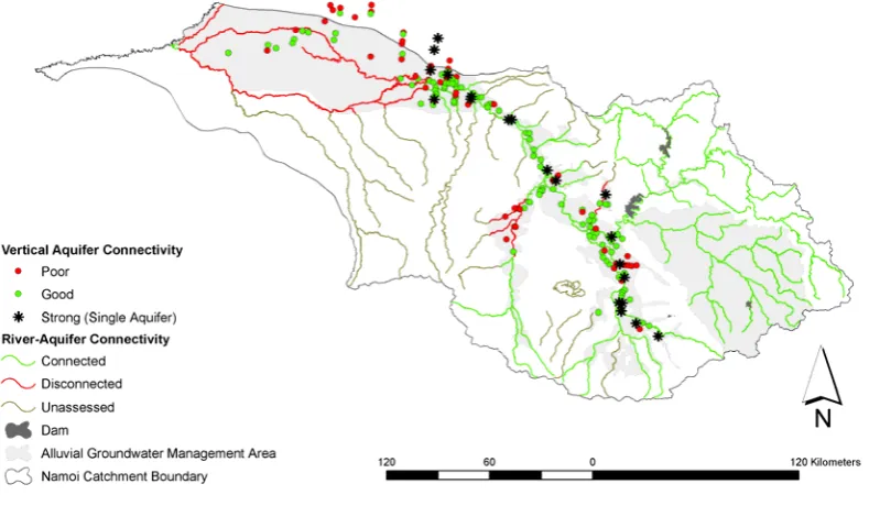
Figure 4-1 River-aquifer connectivity and depths to groundwater within the shallow aquifers (<40m) in the Namoi River catchment ... 43
Figure 4-2 River-aquifer connectivity within the Namoi River catchment ... 44
Figure 4-3 Typical stream hydrograph (adapted from Shaw, 1983)... 46
Figure 4-4 Location of stream gauging stations on the unregulated rivers of the Namoi River catchment ... 49
Figure 4-5 Baseflow indices expressed as a percentage for stream gauging stations on the unregulated rivers in the Namoi River catchment, NSW... 53
Figure 4-6 Percentage of streamflow record over which measurable river flows (>0.01 ML/day) have been recorded by a stream gauging station... 54
Figure 4-7 Typical flow duration curves representing the probability of flows at gauging station 419032, the Cox’s Creek at Boggabri (intermittent reach) and at gauging station 419086, Bundella Creek tributary to Cox’s Creek (perennial reach)... 57
Figure 4-8 Typical baseflow hydrograph for a connected-gaining river reach, Bundella Creek, Cox’s Creek subcatchment (gauging station 419086) ... 58
Figure 4-10 Filtered stream hydrographs for stream gauging stations 419033, 419052 and
419032 in the Cox’s Creek subcatchment over the 11/10/1972 to 20/1/1989 period...63
Figure 4-11 Probability of flows for gauging stations in the Cox’s Creek subcatchment over the 11/10/1972 to 20/1/1989 period ...66
Figure 4-12 Aquifer-river reach connectivity and dominant flux in the Namoi River catchment ...67
Figure 4-13 Location of extraction bores and river reach classification in the Namoi River catchment...70
Figure 4-14 Typical examples of nested bore hydrographs demonstrating a) strong b) good and c) poor vertical hydraulic connection ...72
Figure 4-15 Vertical connectivity at nested piezometer sites (with three or more nests)...74
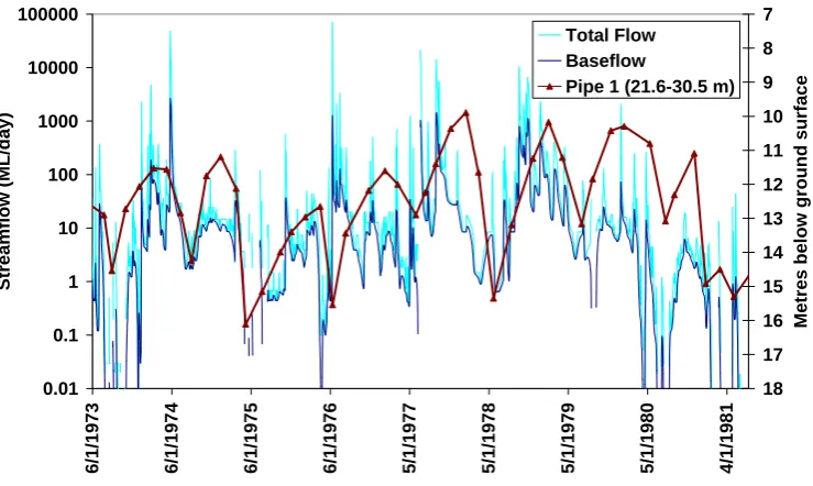
Figure 4-16 Typical examples of paired stream and bore hydrographs illustrating categories demonstrating a) good evidence, or b) poor evidence, of aquifer-river interactions...76
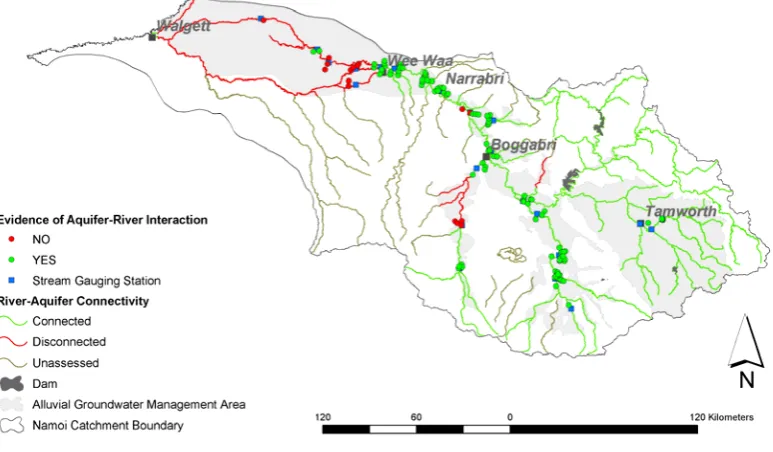
Figure 4-17 Evidence of aquifer-river interaction in the Namoi River catchment based on the analysis of paired stream and bore hydrographs ...79
Figure 4-18 Paired bore and stream hydrograph for gauging station 419032 on the Cox’s Creek at Boggabri with observation bore GW036602...80
Figure 5-1 Conceptual diagram of the IHACRES rainfall-runoff model ...96
Figure 5-2 IHACRES linear module structure ...98
Figure 5-3 IHACRES_GW Model Structure...101
Figure 5-4 Modelled streamflow with varying slow flow volumes ...109
Figure 5-5 Modelled groundwater storages with varying slow flow volumes ...109
Figure 5-6 Modelled flow exceedence percentages with varying slow flow volumes ...110
Figure 5-7 Modelled streamflow with varying slow flow time constants ...111
Figure 5-8 Modelled groundwater storage with varying slow flow time constants ...111
Figure 5-9 Modelled flow exceedence percentages with varying slow flow time constants...112
Figure 5-10 Modelled streamflow with varying quick flow time constants...113
Figure 5-11 Modelled groundwater storage with varying quick flow time constants ...113
Figure 5-12 Modelled flow exceedence percentages with varying quick flow time constants .114 Figure 5-13 Modelled streamflow with varying loss parameter...116
Figure 5-14 Modelled groundwater storage with varying loss parameter ...116
Figure 5-15 Modelled flow exceedence percentages with varying loss parameter ...117
Figure 5-16 Modelled groundwater storages with varying initial values ...118
Figure 5-18 Residual difference between modelled streamflows using the reference parameter
set and the perturbed vs and τs parameter combinations... 122
Figure 5-19 Modelled streamflow for perturbed vs and τq parameter values ... 124
Figure 5-20 Residual difference between modelled streamflows using the reference parameter set and the perturbed τq and vs parameter combinations... 124
Figure 5-21 Modelled streamflow for perturbed τs and τq parameter values... 125
Figure 5-22 Residual difference between modelled streamflows using the reference parameter set and the perturbed τs and τq parameter combinations... 126
Figure 5-23 Modelled streamflow using reference parameter effective rainfall data series for varying slow flow volumes... 129
Figure 5-24 Relative difference in modelled streamflows using effective rainfall data series compared with effective rainfall calculated from observed streamflow as model input for varying slowflow volumes... 129
Figure 5-25 Modelled streamflow using reference parameter effective rainfall series for varying slow flow time constants... 130
Figure 5-26 Modelled streamflow using reference parameter effective rainfall series for varying quick flow time constants ... 130
Figure 5-27 Relative difference in modelled streamflows using effective rainfall data series compared with effective rainfall calculated from observed streamflow as model input for varying quickflow volumes... 131
Figure 6-1 Location of Cox’s Creek subcatchment, groundwater management Zones 9 and 2, extraction bores and gauging station 419032... 136
Figure 6-2 Mean monthly rainfall for the 1/6/1965 - 9/12/2003 period... 137
Figure 6-3 Mean annual rainfall for the 1/6/1965 - 9/12/2003 period ... 138
Figure 6-4 Accumulative residual rainfall for the 1/6/1965 - 9/12/2003 period... 138
Figure 6-5 Observed and modelled streamflow at gauging station 419032, Cox’s Creek at Boggabri, for the calibration period (1/6/1965 to 1/6/1970)... 143
Figure 6-6 Residual difference between observed and modelled streamflow for the calibration period (1/6/1965 to 1/6/1970) ... 143
Figure 6-7 Observed and modelled streamflow at gauging station 419032, Cox’s Creek at Boggabri, for the calibration period (1/6/1970 to 1/6/1975)... 144
Figure 6-8 Residual difference between observed and modelled streamflow for the calibration period (1/6/1970 to 1/6/1975) ... 144
Figure 6-9 Observed and modelled streamflow at Gauging Station 419032, Cox’s Creek at Boggabri, for the calibration period (1/6/1975 to 30/6/1980)... 145
Figure 6-10 Residual difference between observed and modelled streamflow for the calibration period (1/6/1975 to 30/6/1980) ... 145
Figure 6-12 Examples of data infilling in observed streamflow record (1/6/1970-2/6/1972) at Gauging Station 419032, Cox’s Creek at Boggabri ...147
Figure 6-13 Flow exceedence percentages for observed and modelled streamflow for the
1/6/1965 to 30/6/1980 calibration period ...148
Figure 6-14 Daily volumes of groundwater extracted from the alluvial aquifers over the
irrigation season for each water year (ML/day) in the Cox’s Creek subcatchment for the area above gauging station 419032 ...149
Figure 6-15 Observed and modelled streamflow at gauging station 419032, Cox’s Creek at
Boggabri, for the 2/9/1988 to 2/9/1993 simulation period ...152
Figure 6-16 Residual difference between observed and modelled streamflow for the 2/9/1988 to
2/9/1993 simulation period...152
Figure 6-17 Observed and modelled streamflow at gauging station 419032, Cox’s Creek at
Boggabri, for the 2/9/1993 to 2/9/1998 simulation period ...153
Figure 6-18 Residual difference between observed and modelled streamflow for the 2/9/1993 to
2/9/1998 simulation period...153
Figure 6-19 Observed and modelled streamflow at gauging station 419032, Cox’s Creek at
Boggabri, for the 2/9/1998 to 2/10/2003 simulation period ...154
Figure 6-20 Residual difference between observed and modelled streamflow for the 2/9/1998 to
2/10/2003 simulation period...154
Figure 6-21 Flow exceedence percentages for observed and modelled streamflow for the
2/9/1998 to 2/10/2003 simulation period...155
Figure 6-22 Detailed record of observed and modelled flows over the 1989 simulation period
...156
Figure 6-23 Modelled groundwater storage volumes over the 1989 simulation period ...157
Figure 6-24 Detailed record of observed and modelled flows over the 1989 simulation period
with loss parameter set to zero ...158
Figure 6-25 Flow exceedence percentages for observed and modelled streamflow using the
post-development 2/9/1988 to 9/12/2003 calibration parameters ...161
Figure 6-26 Detailed record of observed and modelled flows over the 1989 period using the
post-development calibration parameters...161
Figure 6-27 Location of shallow observation bores closest to catchment outlet at stream gauging
station 419032 ...165
Figure 6-28 Modelled groundwater storage at stream gauging station 419032 and measured
groundwater elevation in observation bores screening the shallow aquifers downstream of the gauging station...166
Figure 6-29 Modelled groundwater storage at stream gauging station 419032 and measured
groundwater elevation in observation bores screening the shallow aquifers upstream of the gauging station...166
Figure 7-1 Modelled groundwater storages for simulation scenarios with and without
Figure 7-2 Residual baseflow volumes between simulation scenarios ... 171
Figure 7-3 Reported annual groundwater extraction rates over the 1988-2003 simulation period
(Department of Natural Resources Database)... 173
Figure 7-4 Modelled groundwater storage volumes and baseflow residuals ... 174
Figure 7-5 Flow exceedence percentages for streamflow simulation scenarios with and without
groundwater extraction ... 175
Figure 7-6 Modelled groundwater storage volumes for simulation scenarios using varying rates
of constant groundwater extraction over the irrigation season in the 1988-2003 period ... 177
Figure 7-7 Effective rainfall estimations based on streamflow data measured at gauging station
419032 over the 1988-2003 simulation period ... 178
Figure 7-8 Modelled reductions in baseflow for varying rates of groundwater extraction over the
List of Tables
Table 3-1 Recharge, variations to recharge estimates, water requirements and licence reductions
at the start of the water sharing plan for the Upper and Lower Namoi groundwater sources (DLWC, 2002) ... 34
Table 4-1 Classification system for river-aquifer interactions relevant to conjunctive use
management (adapted from REM, 2002)... 41
Table 4-2 Flow characteristics at unregulated river gauging stations... 51
Table 4-3 Flow characteristics for gauges in the Cox’s Creek subcatchment over the 11/10/1972
to 20/1/1989 period ... 64
Table 5-1 Summary of previous groundwater models developed for the Namoi River catchment
... 92
Table 5-2 S values for Two-at-a-Time parameter sensitivity analysis of modelled streamflow120
Table 5-3 S values for Two-at-a-Time sensitivity analysis of modelled streamflow using
reference parameter effective rainfall data set ... 133
Table 6-1 IHACRES_GW calibration period (1/6/1965 to 30/6/1980) parameter values and
objective function fits ... 141
Table 6-2 Confusion matrix for calibration period to assess performance of IHACRES_GW
model ... 142
Table 6-3 IHACRES_GW simulation period objective function fits: 2/9/1988 to 9/12/2003.. 150
Table 6-4 Confusion matrix for simulation period to assess performance of IHACRES_GW
model ... 150
Table 6-5 IHACRES_GW calibrated parameter values for post-development period: 2/9/1988 to
9/12/2003 ... 160
Table 6-6 Confusion matrix for the calibration to post-development period... 160
Table 7-1 Events during model simulation with reduced baseflow based on historical rates of
extraction ... 172
Table 7-2 Modelled reductions in baseflow with varying rates of groundwater extraction over
Chapter 1 Research Context
1.1 Motivation
This thesis focuses on the subject of groundwater and surface water connectivity. Groundwater and surface water systems are often managed as if each were an isolated component of the hydrological cycle, and yet these systems interact in a range of geological, topographical and climatic settings (Sophocleous, 2002; Winter, 1999). Many surface water features, such as rivers, lakes, dams and wetlands, will have varying degrees of connection with groundwater systems (Winter, 1999). Accordingly, water can move as a continuum between surface and groundwater systems and the use and/or quality of one resource can impact upon the other.
[image:23.595.237.417.547.751.2]The earliest scientific researchers of hydrology also acknowledged the linkages between surface water and groundwater systems, with surface water hydrologists having long understood that part of the streamflow hydrograph was attributable to groundwater discharge (Boussinesq, 1877; Coutagne, 1948; Horton, 1933; Maillet, 1905) and referring to this discharge as baseflow. Hydrogeologists, or subsurface hydrologists, have also understood that groundwater commonly discharged to rivers and that those rivers also recharged aquifers. They knew that groundwater withdrawals could capture surface water flows and they derived analytical equations in order to calculate the impact of groundwater extraction on river flows (Boulton, 1942; Glover and Balmer, 1954; Jenkins, 1968; Theis, 1941). In spite of the awareness of groundwater-surface water connectivity within the broader hydrological community, the use of distinct research disciplines and methods, differing spatio-temporal scales and research objectives, and divisions within institutional jurisdictions have resulted in groundwater and surface water being managed separately.
The adverse consequences of managing these resources separately are becoming increasingly apparent as the evidence of the impacts of groundwater extraction schemes on declining river flows is documented (Chen et al., 2003; Glennon, 2002; Smakhtin, 2001; Sophocleous, 2000; Sophocleous and Perkins, 2000). Groundwater extraction from aquifers that are connected with river systems will impact upon riverine hydrology by reducing river flows. It has been estimated that between 10% and 90% of the volumes of groundwater extracted within the Murray Darling Basin in southeastern Australia are sourced from water that would have otherwise discharged to a river (SKM, 2002). Altered river hydrology has implications for riverine ecosystem health, water security, aesthetic and cultural values, as well as water allocation and water management policies more generally. The decline in river flows as a consequence of groundwater extractions has the potential to threaten river basin industries and communities. These risks will become greater as the pressures on river and groundwater resources continue to grow as a result of drier than average climatic patterns and increased economic development within river basins.
2000) and other international regulatory frameworks directed to reforming water use and management (Letcher and Giupponi, 2005). It has the aims of increasing the productivity and efficiency of water use, whilst ensuring the health of river and groundwater systems. One of the key objectives of the NWI is to achieve ‘recognition of the connectivity between surface and groundwater resources and for connected systems to be managed as a single resource’ (NWI, 2004). Another key objective is for water allocation in catchments to be managed through integrated catchment management approaches that consider social and economic factors along with biophysical factors. The water reform objectives present a significant challenge to catchment managers.
The implementation of water reforms in Australia has particularly affected the more developed irrigation regions, such as the Namoi River catchment, which is situated within the Murray-Darling Basin in the state of New South Wales (NSW) (see Chapter 3 for catchment setting). The water reforms have resulted in decreased water entitlements for water users in the catchment in order to promote resource security and sustainability. However, a catchment-scale understanding of the interactions between groundwater and river systems remains incomplete. Consequently, the projected outcomes of reduced water allocations remain unclear and contentious. This thesis will explore these issues within the Namoi River catchment. The scope, research questions and aims are discussed below.
1.2 Scope, Research Questions and Aims
trade-offs associated with water allocation and the water sharing plans (Letcher, 2002; Letcher et al., 2004) as part of an integrated catchment management approach to reforming water use and management. One of the areas of input required to improve this hydro-economic model is the inclusion of groundwater-river interaction processes. In particular, the impact of groundwater extraction on river flows presents a risk to sustainable water allocation, which will be explored in this thesis.
Some of the key research questions being asked in the context of this research are:
• How do the interactions between groundwater and river systems change spatially and temporally along river reaches within the Namoi River catchment?
• How can existing water allocation models be improved through this knowledge?
• Are river flows reduced by groundwater extraction and, if so, can the impacts be quantified within the Namoi River catchment?
• How can a greater understanding of aquifer-river connectivity inform policy development, such as water sharing plans, within the Namoi River catchment?
Because of the complexities involved in a comprehensive basin-scale study, the current research has been limited to characterising the interactions between the Cainozoic alluvial aquifers interacting with gauged river systems, and will consider volumetric water allocation issues only (i.e., not water quality or salt mobilisation). The research will be based on available, pre-existing data.
The specific research aims of this thesis are:
1. To develop a broad-scale understanding of the spatio-temporal interactions occurring between aquifer-river systems in the Namoi River catchment, NSW; 2. To improve upon existing water allocation models through the development of a
parsimonious, integrated aquifer-river model that is appropriate for considering the interactions between groundwater and river systems at the basin-scale; and
1.3 Thesis Outline
This thesis has eight chapters which are outlined as follows:
Chapter 1: Research Context
This provides an introduction to the motivation for the thesis research topic, outlines the reasons for the selection of the Namoi River catchment case study area, and specifies the scope and aims of the thesis. An outline of the thesis structure is included.
Chapter 2: Groundwater-River Interactions: Principles
The basic physical principles that govern groundwater-river water interactions are described. The terms used to categorise the types of groundwater-river interactions that occur, and the processes which arise as a consequence of groundwater extraction, are introduced to the reader. The terms and concepts outlined in this chapter set the foundation for discussions in later chapters.
Chapter 3: The Namoi River Catchment
A synthesis of the physical attributes of the Namoi River catchment is provided together with an overview of water resource use and management, including the background history and implementation of water reforms. The response to the national water reform agenda by the State Government of NSW is described, as are some of the challenges to implementing water reforms.
Chapter 4: Characterisation of Namoi River Reaches
The methods commonly used to assess groundwater-river interactions are outlined, a system of classification to categorise groundwater-river interactions is provided, and a framework is developed and applied to characterise the interactions observed in the Namoi River catchment, NSW.
Chapter 5: Model Conceptualisation and Development
conceptual style of model for use in quantifying the impacts of groundwater extraction on river flows at the catchment scale is outlined. The streamflow characteristics that the model development has been intended to capture are listed. The derivation of the IHACRES_GW model, based on the IHACRES (Identification of unit Hydrographs And Component flows from Rainfall, Evaporation and Streamflow data) model, is fully described and a sensitivity analysis is provided.
Chapter 6: Model Application
The IHACRES_GW model is applied within the Cox’s Creek subcatchment in order to test the validity of the model derived in Chapter 5, and to demonstrate if, or how, a simple, conceptual model can be used to simulate the impact of groundwater extraction and other aquifer losses on river flows. A discussion of the model calibration, validation and performance criteria is provided and the overall model performance is assessed together with discussion of potential improvements to the model.
Chapter 7: Extraction Impacts and Water Policy
The IHACRES_GW model is used as a tool to investigate the impacts of groundwater extraction on river flows in the Cox’s Creek subcatchment and to consider water management policies developed as part of the National Water Initiative water reforms. The research findings from this thesis are used to provide insights into how groundwater extraction impacts upon river flows, and some logical steps are suggested to assist with better managing the impacts of groundwater extraction in connected aquifer-river systems.
Chapter 8: Conclusions
Chapter 2 Groundwater-River Interactions: Principles
2.1 Introduction
The interconnections between groundwater and river systems remain poorly understood in many catchments throughout the world, and yet are fundamental to effectively managing water resources. In order to comprehend the full importance of groundwater-river interactions on water resource sustainability, knowledge of the basic principles and relationships guiding groundwater and river water interactions is required. This chapter provides an overview of the basic physical principles that govern groundwater-river water interactions. The terms used to categorise the types of groundwater-river interactions observed and the processes that arise as a consequence of groundwater extraction will be introduced, and the terms and concepts outlined in this chapter will underpin discussions in later chapters. It is assumed that basic terms and principles for groundwater systems are understood, for example confined and unconfined aquifer systems, hydraulic head, transmissivity and storativity. These terms are defined in a number of basic groundwater texts such as Heath (1987) should the reader wish to consult additional references.
2.2 Types of Interactions
Comprehensive reviews of the physical interactions that occur between groundwater and surface water systems have been provided by Sophocleous (2002), Winter et al.
(1998), Winter (1999) and Woessner (2000). Reviews with an emphasis on the ecological significance of groundwater-surface water interactions are given by Boulton
reaches, or both gain and lose in the same river reach at different times (variably gaining-losing river reach; Figure 2-4) .
Figure 2-1 Connected gaining river reach (after Winter et al., 1998)
Figure 2-2 Connected losing river reach (after Winter et al., 1998)
In order for groundwater to discharge to a river, the elevation of the groundwater surface adjacent to the river must be higher than the elevation of the river stage. Conversely, for river water to flow to groundwater, the elevation of the groundwater surface adjacent to the river must be lower than the elevation of the river stage. The direction of water flow between an aquifer and river system depends on the relative differences between the groundwater and river stage elevations. In both cases, there must be permeable material that will allow the movement of water between groundwater and river systems.
function of the elevation of the groundwater; although unsaturated zone storage of water may play a role in maintaining some degree of connectivity (Bouwer and Maddock, 1997).
Figure 2-3 Disconnected losing river reach (after Winter et al., 1998)
Bank storage (Figure 2-4) is a particular type of interaction that occurs when a rapid rise in river stage causes water to move from the river into the streambank (Winter et al., 1998). This process is usually associated with intense rainfall events, rapid snowmelt, or a release of water from a dam. Most of the water in the streambank returns to the river within a few days or weeks. However, if the rise in stream stage is associated with a large flood event that tops the river bank, flooding a large land surface area, then the slow return of water through the subsurface may take longer, and occur over weeks, months or years if the flow paths are sufficiently long and/or slow.
Figure 2-4 Connected variably gaining-losing reach (after Winter et al., 1998)
aquifer, and the extent to which the channel of the river intersects the saturated part of the aquifer (Kirk and Herbert, 2002). The direction of the exchange varies with hydraulic head, whilst the quantity of flow (volume per unit time) depends on the sediment hydraulic conductivity.
Groundwater-river interactions occur on a variety of scales including the larger fluvial plain/river reach scale through to the channel bed scale (Woessner, 2000). Small-scale variability in groundwater and river exchanges in the bed of a channel, or hyporheic zone, can occur within larger reaches characterised as gaining or losing and the hinge line between a gaining and losing reach may rapidly change in response to a change in recharge-discharge dynamics.
The interactions between groundwater and river water systems are dynamic, changing temporally and spatially in response to both natural and anthropogenic factors. Natural climate variability, including seasonal variability, will influence the volumes of precipitation that are available within a catchment, including the volumes available for surface runoff and groundwater recharge processes. Anthropogenic factors, such as stream regulation, land use, the application of irrigation water and groundwater extraction, will also influence groundwater-river stage relationships by altering the hydraulic gradients between groundwater and surface water systems. The geology and geomorphology of the catchment influence where, and how quickly, water moves within the catchment.
For this thesis the impacts of groundwater extraction on river flows are of particular interest, and are discussed below.
2.3 Impacts of Groundwater Extraction on Rivers in Connected Systems
The effective management of water resources where exploited aquifers are in hydraulic connection with river systems requires an understanding of the response of hydrological systems to groundwater extraction.
recharge into a groundwater system equals the discharge out of the system (Heath, 1987; Sophocleous, 2002; Winter et al., 1998) (Figure 2-5A).
With the introduction of an extraction bore and the onset of pumping, a loss of water to aquifer storage occurs and a new state of dynamic equilibrium is approached. This state is accomplished either by a decrease in natural groundwater discharge, an increase in groundwater recharge, or a combination of the two (Sophocleous, 2002). The terms commonly used to describe the response of an aquifer system to a new state of equilibrium are ‘captured discharge’ and ‘induced recharge’. These terms are described in more detail below.
2.3.1 Captured Discharge and Induced Recharge
In an example of an aquifer system located within a connected shallow aquifer-river system, the volume of water that recharges the aquifer will, under natural conditions, equal the volume of groundwater that discharges to the river (Figure 2-5A). Groundwater extraction will reduce the volumes of groundwater stored within the aquifer, and a cone of depression will form as a consequence of pumping. The volume of water that is removed from groundwater storage through pumping will no longer be available as a baseflow discharge to the river because this volume of water has been intercepted by groundwater pumping (Figure 2-5B). The term applied in this case is “captured discharge”.
In a natural system recharge to the aquifer is equal to the discharge from the aquifer
The introduction of an extraction bore results in reduced groundwater storage and reduced discharge (baseflow) to the river (referred to as “captured discharge”)
Groundwater extraction close to a river or over long periods of time may induce river water to flow into the aquifer (referred to as “induced recharge”)
The processes of captured discharge and induced recharge result in decreased volumes of baseflow and surface runoff in a connected aquifer-river system. The examples provided above illustrate the importance of considering the interactions between groundwater and river systems, and highlight the need to manage water resources in connected systems as a common, single resource. Another problem arising as a consequence of not considering connected water resources as a single resource is one of double accounting.
2.3.2 Double Accounting
Groundwater and river water exchanges commonly occur in hydraulically connected systems, as discussed above. As a consequence, double accounting of water resources may arise when connected aquifer-river systems are not managed as a single resource. An example of a situation where double accounting occurs is when groundwater extraction volumes are allocated according to the long-term average annual recharge to the aquifer, or allocated without limit. Yet the discussions above have highlighted the fact that groundwater extraction results in reduced river flows. Thus, if in the same catchment groundwater allocations have not considered the impacts on river flows, then a portion of the river water will inadvertently have been allocated to both the river and groundwater systems, and this situation results in double accounting of water volumes. Double accounting results in the over-allocation of water, erodes water security and compounds the impacts already arising from groundwater extraction on river systems, particularly in highly-stressed catchment systems.
2.3.3 Time Lags
and river system; the rate of groundwater extraction relative to the natural recharge and discharge rates; the type of aquifer (confined, semi-confined or unconfined); the width of the river valley; aquifer and stream properties; aquifer diffusivity (expressed as the ratio of aquifer transmissivity to storativity, which expresses how fast a transient change in hydraulic head is propagated through the aquifer); and the distance of extraction bore from the river (Braaten and Gates, 2004; Kirk and Herbert, 2002). These specific characteristics must be considered for each catchment on a case-by-case basis, as time lags can vary considerably from catchment to catchment and over difference climatic periods.
2.4 Chapter Summary
Chapter 3 The Namoi River Catchment
3.1 Introduction
The Namoi River catchment was selected as a case study area in the thesis for further investigations into groundwater-river interactions. This chapter describes the catchment’s physical attributes and provides background information on water usage, water management and the water reform agenda. The implementation of water reforms poses many difficulties for catchment managers, particularly in highly developed catchments, such as the Namoi, that are reliant on surface and groundwater irrigation. This chapter sets the context for the groundwater-river interaction studies and policy analysis undertaken.
3.2 Catchment Setting
The Namoi River catchment is arguably one of Australia’s most developed irrigation areas where both surface and groundwater resources are heavily utilised for agricultural purposes. The catchment covers an area of approximately 42 000 km2, located in the central-north of the State of NSW (Figure 3-1), and is situated within the larger Murray Darling Basin River system.
stored in dams for later use. The main uses of water in the region are irrigation, stock watering and domestic use (EPA, 1995).
Macdonald River
Split Rock Dam
Keepit Dam
Chaffey Dam
Pian Creek
Namoi River
Cox’s Creek Barradine Creek
Mooki River
Peel River Manilla River
Macdonald River
Split Rock Dam
Keepit Dam
Chaffey Dam
Pian Creek
Namoi River
Cox’s Creek Barradine Creek
Mooki River
[image:38.595.65.463.130.435.2]Peel River Manilla River
Figure 3-1 Location of Namoi River catchment, NSW Australia
The major population town centres include Tamworth, Gunnedah, Narrabri and Walgett. The 1996 census recorded the population of the Namoi River catchment as 93 965, which is mostly concentrated along the river and its major tributaries between Tamworth and Narrabri. The local Indigenous population (the Kamilaroi People) numbers about 4 500 (1996 census), although local knowledge suggests the figure is closer to 6 500 (DPMS, 1996).
3.2.1 Climate
with elevation and show a large diurnal variation. The monthly maximum temperature is highest between November and March (up to 48ºC) and lowest during June, July and August (- 3.8ºC) (DPMS, 1996).
3.2.2 Landuse
The catchment has been used extensively for agricultural activities since the 1830’s. There has been a mixture of sheep and cattle farming, as well as grain crops since the 1960’s, with a gradually larger reliance on cattle (EPA 1994). In the 1960’s, Keepit Dam was completed and cotton was introduced into the Narrabri/Wee Waa districts, producing 30 000 to 40 000 ha of irrigated cotton per year (EPA 1994).
A general map of landuse within the catchment is shown in Figure 3-2. The main agricultural activities today include irrigated cotton and broad acre cropping (mainly sorghum, sunflower and wheat). These occur predominantly along the alluvial floodplains of the Namoi River valley south of Boggabri, in the lower Cox’s Creek subcatchment, and to the northwest of Boggabri through to Narrabri, Wee Waa and Walgett. Sheep and cattle grazing occur throughout the catchment, but are more widespread in the upper catchment area (EPA 1995).
According to the Namoi River Catchment Management Authority (Namoi CMA, 2005), the agricultural production of the Namoi River catchment in 1996 was worth in excess of $800 million annually and accounted for 11% of the State’s on-farm production from only 6.25% of the State’s area. This amount included 15% of the State’s cotton production. Irrigated cotton produces $230 million per annum; grazing enterprises contribute $250 million per annum; dryland agriculture $100 million per annum and other forms of agriculture over $150 million per annum (DPMS, 1996). The two largest employment sectors are agriculture and retail trade. The major growth areas are health and community services, manufacturing and education. Given the large income generated within the catchment from irrigated agriculture, reduced water allocations will have significant impacts on irrigators, towns and businesses within the catchment. Water allocations are migrating to the highest value commodities, such as cotton, in order to cover the high market costs of water.
3.2.3 Geology
The geology of the Namoi River catchment is both complex and diverse, with rocks ranging in age from Devonian through to Cainozoic. There is a vast body of literature on the geology of the region, and readers interested in detailed geological descriptions and historical overviews can find excellent syntheses in Gates (1980) and Lavitt (1999). A map of the simplified geology (Kingham, 1998) is shown in Figure 3-3.
Figure 3-3 Simplified geology of the Namoi River catchment (after Kingham, 1998)
Basalts form the catchment boundary in the southern margins, with most recent volcanic activity having occurred in the Tertiary period. These basalt ranges have been deeply weathered and now make up the fertile floodplains that are used extensively for cropping within the Cox’s Creek and Mooki River catchments that comprise the Liverpool Plains region (DPMS, 1996).
3.2.4 Soils and Physiographic Zones
The distribution of soils in the Namoi River catchment is a function of geology, topography and climate. The broad soil types are shown in Figure 3-4 (GIS data from the NSW Department of Natural Resources (DNR) Database).
Figure 3-4 Soil types in the Namoi River catchment (data from DNR GIS database)
The Namoi basin can be divided into four natural physiographic subdivisions (EPA, 1994):
• Ranges of the upper catchment – This area is located to the east in the Great Dividing Ranges. The region is steep to rugged and was originally characterised by savannah woodland that has been mostly cleared.
• Liverpool Plains – This region comprises the Mooki and Cox’s river catchments. The region is generally flat with slopes rarely exceeding 3°. The soils comprise cracking clays or clay loams with red clay subsoils. Grasses dominate this area, with some remnant patches of the original savannah woodland.
originally lined the flood plain, with natural vegetation communities such as river red gums existing alongside. The trees have since largely been cleared and the river now assumes characteristics of an inland delta.
• Pilliga – This region is located in the southwest of the catchment. This area is mostly flat, and is now predominantly State Forest with extensive woodlands dominated by cypress pine and ironbark.
3.3 Water Resources
The New South Wales Department of Natural Resources (DNR) administers the water resources in the catchment through the use of surface water and groundwater licenses. Water use falls into three main categories: unregulated and regulated surface water and groundwater. The unregulated systems include the portions of the catchment above the major dams (Keepit, Split Rock and Chaffey) and the tributaries that flow into the Namoi River such as Cox’s Creek, Mooki River, Maules Creek and Barradine Creek (Figure 3-1). The regulated systems include the rivers below the dam storages (such as the Peel and Namoi rivers). Licenses exist for all forms of water use.
Both surface water and groundwater resources have been over-allocated and exceed sustainable levels of consumption because of outdated policies originally developed to encourage agricultural development in the region (DLWC, 1999). Groundwater users in particular have recently faced significant cuts in their allocation in order for the resource to be returned to a sustainable level of development as part of the water reform agenda, which is discussed further in Section 3.4.
3.3.1 Surface Water Supply
The allocation of surface water for irrigation is as much as 260 000 ML/year, which is about 45% of the natural median flow (EPA, 1997). In a typical year about 200 000 ML is extracted by the irrigation industry in the Namoi River catchment (DPMS, 1996). All of the allocation water is generally used, as well as a volume of off-allocation surface water that flows from unregulated tributaries or overflows from the dam storages when not allocated to other purposes such as environmental needs (EPA, 1997). The volume that water users can actually extract varies from year to year depending on the storage levels. The DNR announces allocations after allowing for essential reserves for town water supply, stock and domestic, high security entitlements and a carry over for the following year. Because of the drier climatic conditions over the last decade, the allocations given to the irrigators were commonly well below 100%. The surface water resources of the Namoi River catchment are considered to be fully committed for irrigation purposes and there are no plans for the development of additional large-scale storages (DPMS, 1996).
The combination of dam storages, water extractions and diversions has had substantial effects on the flow characteristics of rivers within the catchment. Seasonal patterns have changed, flow variability has been reduced (for regulated reaches) and flows in the lower parts of sub-catchments have been significantly reduced. For example, average flows to the Barwon River have now dropped by one third (DLWC, 1998). These factors have all contributed to the declining health of the rivers in the Namoi River catchment, resulting in increased algal blooms, declines in native fish stock numbers, increases in exotic fish species, loss of riparian vegetation and decline of wetlands (EPA, 1997). Little is currently known about the role of groundwater extraction on reduced river flows within the catchment, which is one of the key research areas for this thesis.
3.3.2 Groundwater Supply
The Namoi River catchment alluvium (Figure 3-5) is the most intensively developed aquifer system in NSW, accounting for nearly 40% of the total volume of good quality groundwater extracted in the State. Irrigation is the main use of groundwater. Its use varies from 140 GL to well over 200 GL per year, depending on seasonal conditions and the amount of water available from the dams. Groundwater allocations in the catchment are managed on the basis of groundwater management areas and zones, which were defined by the Department of Natural Resources based on distinct hydrogeological characteristics (Figure 3-5). The region has been divided into the Upper and Lower Namoi Alluvium and the Peel Alluvium for management purposes. The Peel Alluvium, although located in the Upper Namoi, is considered to be a separate management area. The total volume of groundwater entitlements in the Upper Namoi is approximately 253 GL and for the Lower Namoi is 156 GL, although these entitlements are currently being reviewed to ensure long term sustainable usage (see Section 3.4.2). There is little reported information on allocations within the Peel Management area. In a recent consultancy report (SKM, 2003), both the Lower and Upper Namoi Alluvium were listed as priority areas for detailed studies on stream-aquifer interaction.
3.3.2.1 Upper Namoi Alluvium
Figure 3-5 Groundwater management areas and zones within the Namoi River catchment
The main aquifer systems in the Upper Namoi Alluvium include the Narrabri and Gunnedah Formations, and comprise unconsolidated sediments associated with the Cox’s Creek and the Mooki and Namoi rivers. The total area of alluvium in this region is in the order of 3 000 km2 with a maximum thickness of 170 m. The Upper Namoi Alluvium yields large supplies of groundwater with a Total Dissolved Solids (TDS) concentration less than 3 000 mg/L.
The lower aquifer (Gunnedah Formation) contains gravels and sands, whilst the upper aquifer (Narrabri Formation) contains mostly clays and silts. Poorly-connected sand and gravel ‘shoestring’ aquifers can be found throughout the Narrabri Formation. The Narrabri Formation acts as a semi-confining layer, and the two formations are in partial hydraulic contact.
Recharge to the Gunnedah Formation is at the southern, upstream end of the aquifer where extensive alluvial fans have been deposited by the upland creeks on the lower hillslopes of the ranges. Diffuse recharge and occasional flooding on the alluvial plain contributes recharge to the Narrabri Formation. Upward flow to the Narrabri Formation occurs through vertical leakage from the underlying pressurised Gunnedah aquifer, which also receives upward vertical leakage from the underlying Basalt bedrock aquifer. Local water tables can be elevated due to the resulting poor drainage. Figure 3-6 (after Stauffacher et al., 1997) provides a simple illustration that conceptualises how groundwater flows within the Mooki catchment.
Figure 3-6 Conceptualisation of the Upper Mooki River Catchment groundwater flow system (after (Stauffacher et al., 1997)
restrictions within the Gunnedah Formation have resulted in local surface salinisation where groundwater discharges to the soil surface.
3.3.2.2 Lower Namoi Alluvium
The Lower Namoi Alluvium extends from Narrabri to Walgett in the west of the catchment (Figure 3-5). The Lower Namoi Alluvium has seven management zones that are described in the DLWC (2000) Lower Namoi groundwater status report. Comprehensive overviews of the geology, hydrogeology and hydrochemistry can be found in Gates (1980), McLean (2003) and Williams (1997).
The groundwater resources in the Namoi Valley are largely contained within the unconsolidated Cainozoic alluvial sediments deposited along the Namoi River, its tributaries and ancestral palaeochannel. Three multiple aquifer systems in the Namoi River catchment have been classified on the basis of age and compositional differences (Gates, 1980; McLean, 2003; Williams, 1985; Williams, 1997). The Cainozoic alluvial sediments of the Lower Namoi Valley comprise interbedded clays, sands and gravels, which have been accumulating for more than 15 million years within the broad valley of the Namoi River. They form a highly heterogeneous alluvium which overlies the pre-Tertiary bedrock surface of the Great Artesian Basin. The alluvial deposits occur to a maximum depth of 120 m and have an areal extent of about 5 100 km2. In the northwest of the catchment the Namoi River alluvium joins alluvium associated with the Barwon and Gwydir river catchments (DLWC, 2000).
situated slightly north-northwest of the present-day river course. In some areas of the Lower Namoi Alluvium the three aquifer systems act as a single aquifer.
The sand and gravel deposits in the Gunnedah and Cubbaroo Formations provide the most productive aquifers for irrigation. Good bore yields with good quality water occur in the Gunnedah and Cubbaroo Formation aquifers, with water quality generally deteriorating to the west with the fining of sediments. The Gunnedah and Cubbaroo Formations have transmissivities ranging from 1000 to 2000 m2/day and hydraulic conductivities of 31 and 23 m/day respectively, and they form the principal productive aquifers in the catchment (Merrick, 1999).
Recharge to the aquifer mostly occurs in the alluvial fan area in zone 5 (LN05 in Figure 3-5), which spreads westward from Narrabri. Groundwater flows are generally in a westward direction towards the town of Walgett. Only a small portion of the total groundwater flow comes from upstream of Narrabri (Upper Namoi Valley). The groundwater system in the Lower Namoi Alluvium is mostly recharged by river transmission losses and weir leakage, rainfall infiltration through the overlying clays, floods and farm water losses. Upward leakage from the deeper underlying Great Artesian Basin aquifer also recharges the alluvial aquifers (McLean, 2003).
Figure 3-7 Schematic cross section of Lower Namoi hydrogeology and water movement processes (after McLean, 2003)
3.3.2.3 Peel Management Area
(DPMS, 1996). No groundwater status reports have been prepared for the Peel Management Area.
3.4 Water Reform
Since the early days of Australian settlement water management in NSW has been primarily aimed at consumptive issues such as the provision of water for towns and the development of private and public irrigation schemes. The concept of water “conservation” revolved around storing water for use during drier times, the building of dams, using rivers as water supply channels and apportioning available water between competing individual interests. The water needs of the environment were given a low priority (Tan, 2002).
In the 1970s it became apparent that the water resources in many parts of NSW were over-allocated and that if all requests for water delivery were made, as per a licence or other agreement, the demand for water would exceed available surface water supplies. In order to address the problem of surface water over-allocation, new measures were introduced during the late 1970’s and through to 1984. These included: an annual volumetric allocation scheme; an embargo on new water allocation licence applications in over-allocated catchments; and “shortage powers” to suspend surface water extraction during times of water scarcity.
In 1984, problems regarding the administration of the State’s water resources prompted an audit of NSW water agencies, which resulted in a restructuring of the administration in rural water services and the development of the Water Administration Act 1986 and Water Authorities Act 1987. For the first time, the ecosystem requirements for water were acknowledged in water legislation (Tan, 2002).
3.4.1 Council of Australian Governments Water Reform Framework
resources to achieve full cost recovery; (4) establishment of a water transfer market through separating rights to water from title to land; and (5) separation of operator and regulator functions in water resource management (COAG, 1994).
COAG membership comprises the Prime Minister, State Premiers, Territory Chief Ministers and the President of the Australian Local Government Association. COAG has the role of initiating, developing and monitoring the implementation of policy reforms of national significance where cooperative action by Australian governments is required. Policy reforms that are agreed to by COAG are developed and implemented by Commonwealth-State ministerial council committees that include responsible ministers from each government. Resolutions made by ministerial council committees require a unanimous vote, which means that decisions taken by the Council represent a consensus of government opinion and policy (Murray Darling Basin Commission, 1999). The Murray Darling Basin Ministerial Council (MDBMC) is responsible for issues of significance to the Murray Darling Basin region.
The MDBMC confirmed that increasing levels of surface water diversions were resulting in the decline in river health and decreased security for water users. Water use in the Basin was found to be growing primarily from the activation of previously unused licenses along with the growth in the use of “off-allocation” water, or water diverted during high flow periods and stored in dams for later use.
In order to ensure that adequate water remained within Murray Darling Basin river systems, the MDBMC announced the Murray Darling Basin Ministerial Cap in July 1995, or the Cap. The Cap gave an upper limit on the amount of water that could be taken from surface water systems, and was defined as “the volume of water that would have been diverted under 1993/94 levels of development”. In unregulated rivers, the Cap was expressed as an end-of-valley flow regime (Murray Darling Basin Commission, 1999). Whilst a Cap was placed on surface water diversions, no Cap was placed on groundwater extractions in the context of their impact on surface water flows. This is an area of research that is of key importance to effectively managing the water resources in the Murray Darling Basin river catchments and will be explored in this thesis.
Management Council of Australia and New Zealand (ARMCANZ) prepared two landmark documents that made the COAG groundwater principles operational. These documents were entitled: “Towards a National Groundwater Management Policy and Practice” (November 1995) and “Allocation and Use of Groundwater – A National Framework for Improved Groundwater Management in Australia (December 1996). Some key recommendations included (ARMCANZ, 1996):
• Groundwater management policies should be directed at achieving sustainable use of the resource;
• Groundwater and surface water resource management should be better integrated; and
• Where allocations exceed the sustainable yield, strategies should be developed to reduce abstractions to sustainable levels within time-frames that minimize permanent damage to the resource.
COAG decided in 1995 that the implementation of the reforms would be included under the umbrella of the National Competition Policy. This meant that the National Competition Council (NCC) would assess and report to the Federal Treasurer on the progress of all States and Territories in implementing water reforms. The Australian Government commenced making National Competition Policy payments to the States and Territories (on a per capita basis) when they achieved satisfactory progress against the water reform obligations. The vision of the Government was for water reforms to be successfully implemented in order to assure an efficient, flexible, sustainable Australian water industry capable of delivering higher quality water with greater security of supply. Water would be properly priced and the rights to water extensively traded (Smith, 2000).
3.4.2 New South Wales Response to COAG Water Reform Framework
In 1997, the NSW Government announced a comprehensive water reform package aimed at improving the health of rivers and groundwater systems within NSW and delivering greater water security to all water users and regional communities.
The “New South Wales State Groundwater Policy Framework Document” was released in 1997 and included three component policies on Groundwater Quality Protection, Groundwater Quantity Management and Groundwater Dependent Ecosystems. The goal for the management of groundwater in NSW was stated as being (DLWC, 1997): “To manage the State’s groundwater resources so that they can sustain environmental, social and economic uses for the people of New South Wales”. These documents defined the concept of the “Ecologically Sustainable Yield”, which required that total groundwater allocations in all groundwater systems in NSW should be no more than 100% of the long term estimated average annual recharge (EAAR) to the systems. Allocations in areas with groundwater-dependent ecosystems were to be made less than 100% of EAAR. According to these principles, groundwater allocations in NSW were reviewed and the Namoi Valley was highlighted as one of the priority areas where the groundwater resources were seriously over-allocated with regard to their corresponding EAAR (NGERP, 1999).
3.4.2.1 Namoi Groundwater Expert Reference Panel
The groundwater management policies of the early 1980’s in the State of NSW allowed for up to one third of aquifer storage to be depleted over a specified time-frame. This policy of “controlled depletion” allowed annual allocations and extractions in excess of groundwater recharge. The ongoing increase in development in some groundwater zones within the Namoi resulted in regional water quality and water quantity declines within the aquifers, which were exacerbated during drought years.