Citizens
'
Observatories for Situation
Awareness in Flooding
Vitaveska Lanfranchi
University of Sheffield, UK
v.lanfranchi@sheffield.ac.uk
Stuart N. Wrigley
University of Sheffield, UK
s.wrigley@sheffield.ac.uk
Neil Ireson
University of Sheffield, UK
n.ireson@sheffield.ac.uk
Uta Wehn
UNESCO-IHE Institute for Water Education
u.wehn@unesco-ihe.org
Fabio Ciravegna
University of Sheffield, UK
f.ciravegna@sheffield.ac.uk
ABSTRACT
Citizens’ observatories are emerging as a means to establish interaction and co-participation between citizens and authorities during both emergencies and the day-to-day management of fundamental resources. In this paper we present a case study in which a model of citizens’ observatories is being been translated into practice in the WeSenseIt project. The WeSenseIt citizens’ observatory provides a unique way of engaging the public in the decision-making processes associated with water and flood management through a set of new digital technologies. The WeSenseIt citizens’ observatory model is being implemented in three case studies based in the UK, the Netherlands and Italy. We describe the findings and our experiences following preliminary evaluations of the technologies and the model of co-participation and describe our future research plans.
Keywords
Citizens’ observatory, water, flood, sensor, modelling, governance
INTRODUCTION
Climate change is expected to significantly affect water quality, water availability and flooding. Predictions indicate that over the next 70 years there will be a doubling in both the number of people affected by flooding each year (to 0.5-0.8 million) and in the annual damages (increasing to 7.7-15 billion €) (Ciscar, 2009). Yet water-related decisions are complex because they affect a variety of interests that are often in conflict, such as the environment, economic development and society. Traditional approaches to observing the water cycle on Earth such as Earth observations through satellites and in-situ observations through monitoring networks have two major drawbacks. First, the density and resolution of the collected data is still too low to describe the status of the water cycle, even when both spatial and in-situ observations are considered complementary. This is particularly the case during anomalous (critical) events such as floods and continuing droughts. Second, it promotes a passive role for the community with regards to understanding the environment, i.e. citizens are traditionally considered consumers of information services at the very end of the information chain.
Proceedings of the 11th International ISCRAM Conference – University Park, Pennsylvania, USA, May 2014
In this context, citizens’ observatories are emerging as a means to establish interaction and co-participation between citizens and authorities both during emergencies but also during the day-to-day management of fundamental resources. WeSenseIt is a EU FP7 project (funded from 2012 to 2016) developing citizen observatories of water and flooding and thereby defining a framework in which authorities and citizens cooperate in:
(i) sharing collective intelligence about events and places,
(ii) supporting a shared situation awareness, not only to improve response and recovery, but also to improve prevention, protection and preparedness for future emergency situations (e.g. floods), and understanding citizens’ needs,
(iii)implementing new approaches to participation in planning, decision making and governance
In a citizens’ observatory, all parties are active participants: creating knowledge about the situation in a participatory manner and contributing to dealing with the situation. In the observatory, citizens will be encouraged to provide information to authorities and to other citizens; this in turn requires that authorities and organisations can comprehend the information which is provided by citizens and provide information in a form which is best suited for citizen consumption. To establish and maintain co-participation, it is fundamental to provide means to:
(i) engage citizens in directly interacting with authorities and other stakeholders; (ii) provide services for viewing, requesting and feeding back information.
The WeSenseIt project has been running for 15 months during which time a significant amount of work has been conducted with respect to the design and installation of sensors, development of the observatory infrastructure and establishing community engagement. We view our preliminary work as a case study of how to establish a citizen observatory from which we can draw preliminary lessons for the next phase of work in WeSenseIt.
The purpose of this paper is threefold. First, it presents the model of citizen observatories and the technologies that WeSenseIt has developed to support the model. Secondly it presents the outcomes of a preliminary evaluation of the technologies and how they address the need of citizen engagement creating the basis for collaboration. Finally, it presents a number of practical issues and concerns encountered during the first phase of the project and the challenges for our future research.
WHAT IS A CITIZENS’ OBSERVATORY?
We define a citizens’ observatory as “a method, an environment and an infrastructure supporting an information ecosystem for communities and citizens, as well as emergency operators and policymakers, for discussion, monitoring and intervention on situations, places and events” (Ciravegna, 2013).
The proliferation of Web 2.0 services and web applications have introduced new opportunities for citizen co-participation in knowledge creation. Google Earth is possibly one of the best-known examples of the way in which citizens and organisations can collaborate to enrich geographical information (Goodchild, 2007). Similar widely used services that build on the knowledge of citizens include Wikimapia, Flickr, OpenStreetMap, etc. While such efforts can produce large-scale knowledge, the full potential of citizens is better realized when their opinions, views and concerns are highlighted and shared with authorities and vice versa in a collaborative and seamless manner. Several tools and applications have been developed over recent years to understand how crowdsourcing, citizen sensing and sensor technologies can be applied for health surveillance and crisis management. Kamel Boulos, Resch, Crowley, Breslin, Sohn, et al. (2011) provide a survey of several such tools and application areas. This phenomenon is strictly linked with the idea of citizen science, i.e. a research technique that enlists the public in gathering scientific information (Bhattacharjee, 2005). Citizen science is particularly active in the environmental domain (Bonney, Cooper, Dickinson, Kelling, Phillips et al., 2009), with many initiatives that aim to collect, compile and study environmental data from users’ observations, ranging from observations of the universe (Raddick, Bracey, Gay, Lintott, Cardamone, Murray, Schawinski, Szalay and Vandenberg, 2013) to animals (Donnelly, Crowe, Regan, Begley, and Caffarra, 2013) and weather/air information (Snyder, Watkins, Solomon, Thoma, Williams, Hagler, Shelow, Hindin, Kilaru and Preuss, 2013). A summary overview of citizen science initiatives for the environmental domain is provided in (Haklay, 2013) and weather observations. Strong efforts have also been made at the level of shared infrastructures (Becker, Mueller, Hotho, & Stumme, 2013) and data standards (Mazzetti, Nativi, Santoro, & Boldrini, 2013) to support sharing of information.
wide range of platforms for citizen-based data collection and sharing. For example, WeKnowIt1 investigated the
use of collective intelligence with a specific case study in Emergency Response. Other projects that emphasise the need for citizens participation are COBWEB2, aimed at studying crowdsourcing techniques for collecting
environmental data and CITI-SENSE3, aimed at developing citizen’s observatories to raise environmental
awareness among citizens and understand how their participation influences environmental decisions. While existing tools and technologies can enable citizens to collaborate with authorities, it is important to investigate how such methods can be included in decision-making processes, whilst respecting the privacy and ethical concerns of citizens. Citizen Observatories or Citizen Science projects may differ quite a lot in the modalities that are used to collect, store and share volunteers observations, from low tech modalities (such as collection of observations via post) to high tech modalities (such as mobile applications, dedicated sensors etc.).
WeSenseIt is a project that puts an emphasis on delivering highly innovative technologies to support citizens, communities and authorities in getting “up-to-date” situation awareness about a situation while respecting the different roles and information needs. On a technical level it consists of a combination of crowdsourcing and custom applications designed to empower and foster participation with the objective of creating an enriched knowledge base to facilitate decision making while increasing opportunities for citizen engagement in their community. We base data capture on:
(i) innovative sensor devices which can be used directly by the citizens and
(ii) exploitation of the citizens’ collective intelligence through crowdsourcing and social networks communications (e.g. Twitter, Facebook, etc.) analysis.
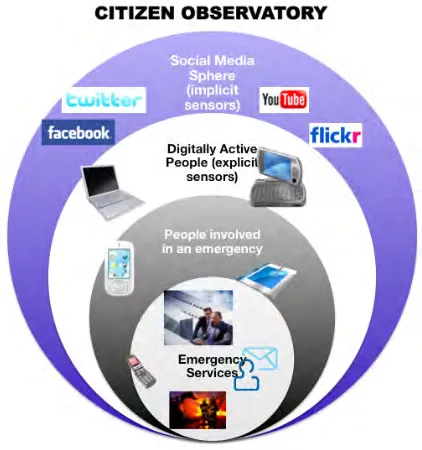
[image:3.595.192.403.405.630.2]Figure 1 illustrates our model of the citizens’ observatory: a set of concentric circles that are characterized by different types of information needs and of information gathered and shared. The circles represent different types of stakeholders: emergency services (or authorities), people involved in an emergency, explicit sensors (digitally active people that share information purposely with authorities), and implicit sensors (digitally active people that share information on social media, without an explicit intention for this information to reach the authorities or emergency services). The aim of our research is to support all the stakeholders by designing innovative sensors and applications that support co-participation.
Figure 1 - The WeSenseIt Citizens’ Observatory Model
WESENSEIT CITIZENS’ OBSERVATORY: THE IMPLEMENTATION
In order to design technologies and applications suitable for the different stakeholders, WeSenseIt has adopted a
1 http://www.weknowit.eu
Proceedings of the 11th International ISCRAM Conference – University Park, Pennsylvania, USA, May 2014
user centred design approach, where stakeholders have been involved from the beginning, firstly in the definition of the observatory idea, then in the design of the applications and in their evaluation.
The technical implementation of WeSenseIt is based on multiple sensors and applications:
• A set of innovative low cost sensors for reading variables such as water level and water flows. Such sensors have designed to be used both by professionals and citizens alike;
• A set of traditional, high-cost sensors for remote reading of variables
• A mobile app designed to support communication and sharing of fundamental information during emergency situations. This app supports users in sharing physical sensor readings.
• A tool for social media analysis: WeSenseIt has adopted and customized a pre-existing tool, TRIDS (Lanfranchi, 2012), to capture, analyse and visualize large-scale, real-time social media data.
• A Web/Mobile Application to access all the communications and the sensor readings
In the following section we will discuss the new innovative sensors and the mobile app that have been already implemented and evaluated in the project.
WeSenseIt Innovative Sensors
A core goal of the project is the provision of simple, easy to use, and affordable sensing technology for the observation of water and water-related variables to citizens and to the scientific community. Depending on sensors, variables of interest, cost, and skills of operators, the objective of citizen involvement have been considered for the different sensing systems selected. In parallel with citizen involvement, WeSenseIt is also advancing state of the art technologies by developing novel sensors and observation techniques yielding useful water-related information whilst at the same time reducing the costs of existing sensor technology or sensing systems. The latter will allow larger numbers of sensors to be deployed and increase the temporal resolution and spatial coverage of the subsequent measurements. Our approach is twofold. We deploy traditional sensing systems which are autonomous and precise but, due to their cost, are few in number. Furthermore, in order to ensure accuracy, they require regular maintenance to ameliorate environmental factors. The second approach is the use of low-cost static or mobile citizen-supported sensing systems. Although less accurate, their low cost allows large quantities of data to be collected allowing statistical methods to reduce inaccuracies or anomalies and extract trends which would otherwise be difficult to observe.
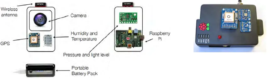
[image:4.595.80.512.596.723.2]In the first phase of the initiative, research activity was focused on developing and deploying sensors to measure water related variables such as water level and water flow. A number of high-quality, traditional sensors have been used to gather data about water level; water quality; soil moisture and a number of weather stations collect data about air temperature and relative humidity, precipitation, etc. All of these sensors are fully autonomous and, once installed, do not require any intervention to collect the sensor measurement data: communications are performed wirelessly over cellular networks. To facilitate citizen engagement in the reporting of flooding events, dangerous locations and critical situations we have developed a number of means to estimate the level of danger and communicate it to both fellow citizens and the local authorities. The aim of these sensors is to enable large-scale public participation by making available a large number of cheap sensors that provide reasonable quality information (even if not expected to match the precision levels of the traditional, high-cost sensors described above). One of these is a Raspberry Pi-based sensor for monitor water level, velocity and rain intensity (Figure 2). The objective is to have a large number of sensors providing spatial patterns and temporal evolution and real-time information for decision-making.
Figure 2 – A Raspberry Pi sensor for water flow and depth: the schema (left) and the actual sensor (right)
category - passive sensors - includes devices such as water depth gauge boards and snow depth gauge boards. These are solid boards with clear gradations and numerical markings for indicating depth of water (in rivers, canals, locks, navigation channels, tidal waterways, etc. – see Figure 5) or depth of snow. They are relatively cheap to manufacture and install and, once in place, they require very little maintenance. When installed by the WeSenseIt project, small information notices are situated close by providing information about the initiative, the sensor itself and instructions on how to read and submit the sensor data. In the current phase, the latter is achieved by using the free WeSenseIt mobile application (see below) to scan the QR code on the notice (encoding information such as sensor type, geographical location, etc.) and then entering the depth observation. In order to maximise citizen engagement, sensors and notices are placed on well-used thoroughfares to ensure the submission of a sensor reading requires as little time as possible.
The second type of citizen engagement sensor - active sensors - are targeted at citizen scientists and those citizens with a stronger interest in the water management of their area. We have developed a low-cost sensor array built around the Raspberry Pi platform. This provides a small, mobile sensing device which can provide information about temperature, barometric pressure, light levels as well as estimating water course flow rate without the need for approaching the water course or using dedicated flow meters. The device is lightweight allowing it to be carried to a number of locations and is quick and simple to use. Sensor data is collated on the device along with geographical coordinates. Once the user has returned to their home, it can be connected to their broadband router at which point all the sensor data is submitted to the central data repository. Such sensors are being distributed to volunteer flood wardens who will take the device to a number of locations in their locale to make measurements. One of our core design goals for these devices was that they were to be easy to build and easy to adapt. All design information is available as open source to allow citizen scientists to build their own versions of the sensor array and augment or improve the range of variables measured.
WeSenseIt Citizens’ Observatory Mobile App.
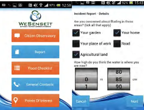
[image:5.595.182.431.417.608.2]The mobile app is the core of the Citizens Observatories vision, as it provides citizens and authorities with a real-time data and observations aggregator that provides additional services to all stakeholders. This is a custom mobile app that interacts with an existing social media platform to provide a familiar interface for users to gather and share information. The mobile app contains several functionalities to facilitate co-participation:
Figure 3 – Citizens’ Observatory mobile app – main screen (left) and sensor report (right)
1. Direct reports and sensor readings. Citizens can submit reports about an area of interest or a threatening situation (e.g. flooding, emergencies, etc.) either by taking a photo and accompanying it with observations or by submitting the value of a sensor (e.g. water meter pole, rain gauge, etc.). Sensor values can be transmitted by scanning a QR code to identify the sensor and typing the sensor reading.
Proceedings of the 11th International ISCRAM Conference – University Park, Pennsylvania, USA, May 2014
3. Requests for information. Authorities (or citizens) can communicate crowdsourcing tasks to citizens and staff members on the ground. For example, authorities can request water level sensor readings from citizens living in remote areas.
4. Alert features. Important information which is provided by other users and/or authorities and emergency services containing important updates on an evolving situation
5. Interactive flood plan checklists. Citizens can browse official flood checklists and tick every completed action. This serves as a useful tool for citizens to keep track of their actions during chaotic moments but also as a real-time notification tool for the authorities to assess the preparedness of individual communities.
Decision Support Web Application
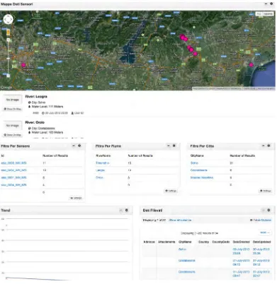
[image:6.595.76.467.306.708.2]To support quick and evidence-based decision making we designed a web interface, Kite (see Figure 4), that functions as the main point of access to all the citizens’ observatory information for both citizens and professional (each with different access rights). Kite collects data via the platform architecture from all types of sensors and from the mobile application and aggregates them. Data is displayed using multiple widgets such as a map (with location of sensors and water gauges) and as filters that by river, by city, by sensor etc. (see Figure 4). The system allows users to view all the possible information for a specific river on a specific date, including readings from “professional” sensors, low-cost sensors and visual readings from users, with details of when and where the readings were taken and the report submitted. This information could be cross-checked with the flood checklist completion for a specific area, to quickly assess preparedness of citizens in an "at-risk" area.
Figure 4 - Decision Support Web Application – main interface for the Italian use case
FIELD TRIALS
the prototypes to gather feedback that will be incorporated in further versions of the platform. In particular we carried out a set of field trials in UK and Italy (two of the project case study locations) during Summer 2013 to understand the usability and user experience with technologies such as the neighbourhood discussions, the flood checklist and the sensor readings functionality.
The field tests were carried out with two sets of stakeholders: citizens (12 participants) and emergency
planners/practitioners (14 participants). All the citizens have suffered from flooding issues in the past and some of them are voluntary flood wardens. The sample size was low, as this was a preliminary field test and not a full evaluation, therefore we were not looking for a statistical validity of the data but mostly for addressing a specific real-life problem through an active approach of intervention and evaluation (Sei, Henfridsson, Purao, Rossi & Lindgren, 2011).
The test was task-based, i.e. the users were asked to carry out a set of typical tasks aimed at exploring the various functionalities. To support the tests, water level gauges were installed in “sensitive” locations to allow citizens and practitioners to easily read and communicate water levels (see Figure 5)
Citizens were asked to visit the locations and submit reports of the situation, participate in shared discussions using the mobile app and check their flood preparedness using the checklist. Practitioners were asked to evaluate incoming reports, discussions and preparedness.
In order to collect feedback, all the participants were asked to complete a questionnaire concerning their background and the experience with the applications and they were debriefed either in person, via telephone or via email. The usage of the applications was monitored via logs. All data (logs, questionnaire and interview) has been kept strictly confidential and anonymised.
Results
The WeSenseIt citizens’ observatory technologies were appreciated by both citizens and practitioners during the evaluation, with particular interest in the ability to submit sensor readings. The sensor reading functionalities
rated very high as, in the words of Participant n.3:
“now the city council will believe me when I say the water in my back garden stream is high”
In general, there was a shared perception that being able to give quantitative data would make any report stronger and likely to increase the authority's confidence in both the person that submitted the report and in the report itself. The idea of attaching a photo to corroborate the evidence further improved the participants’ experience, as they felt it would increase the validity of their report and therefore the likelihood for the authorities to intervene.
This feeling was confirmed by the practitioners: when analysing the submitted reports they rated as higher (both in interest and in likelihood to intervene) those reports that had both a sensor reading and a photo to document the situation. Most practitioners also expressed willingness to corroborate sensor readings submitted by citizens by comparing them with water levels transmitted by official physical sensors in nearby locations.
[image:7.595.105.509.391.547.2]Both the sensors and mobile app generally rated highly for ease of use and user experience. Participants who disagreed with this tended to be elderly users unfamiliar with social networks and smartphones. The highest correlations between background profile and experience and ease of use was, unsurprisingly, found between
Proceedings of the 11th International ISCRAM Conference – University Park, Pennsylvania, USA, May 2014
owning a smartphone and making use of social networks (p > .667); between making a high use of social networks and a positive overall impression (p > .509); and judging the system easy to use (p > 543). This is likely to be due to the deliberate similarities between the WeSenseIt app and existing social network functionalities and interfaces.
As we asked the participants to rate the features in terms of ease of use, interestingness and usefulness we were able to understand which features were more useful. A very interesting observation was made by an elderly participant who, despite struggling with typing on the smartphone and remembering the correct functioning of the app, rated the features as very interesting and useful and commented that she would “learn to use anything to give the right information to the right people”. During the evaluation one citizen commented on how “during an emergency they need more people on the territory to reassure people of the situation” and the app could help them feeling reassured.
All the features rated high in terms of interestingness and usefulness, with the most interesting being the possibility to submit reports, the discussion area and the flood checklist. With respect to usefulness, the most useful were the contact numbers, the flood checklist and the points of interest.
Particular praise was given to the “citizens’ observatory messaging functionalities” by the professional users, For example “I like this feature as neighbours will be able to see what is happening in their area, what has been reported and what is being done about it. Also may help communities come together and support each other in a flood event”.
LOGISTICAL LESSONS LEARNED AND EXPERIENCES
During the field trials and the current formal evaluation (December 2013 - March 2014) a number of logistical issues have arisen which were not adequately foreseen during the initial planning phase of the project. In addition to informing the next phase of work, these issues are sufficiently general as to be of interest to the wider community engaged in citizen science and observatory-like activities.
Sensor installation
All the sensors described above are sourced from members of the WeSenseIt consortium and agreements are in place for the costs of those sensors to be absorbed by the supplying partner. However, the financial costs and time required of installation were underestimated.
For example, the assets to which sensors are attached do not necessarily belong to the local authority and, in some cases, may be of historic importance. Delays are incurred in contacting the relevant agency, explaining the purpose of the project and obtaining permission. Further delays have been observed during the installation preparation and execution. For instance, some sites require that the adjacent road be closed for the safety of the engineers and to provide access for specialist equipment. In Doncaster, for example, there is a 6-8 week lead-time for road closures. In addition, multidisciplinary teams are required for the installation to be successful. A number of the professional sensors require an electrical supply to be made available (usually from nearby street lighting infrastructure) thus requiring cabling to be laid to the installation site and electrical technicians to make the connection. Coordinating such teams to be on-site at the same time introduces delays.
In addition, the various teams within the local authority were keen to establish the efficacy of each type of sensor before committing resources to install all of each type. Therefore, one sensor tends to be trialled for a period before the remaining ones are installed. In fact, this approach highlighted a number of technical issues with the sensors which were able to be addressed before a full roll-out (thus saving time and money).
Local authorities with the expertise to install professional sensors are commonly split into business units with unit being required to operate at a profit. Those local authorities without relevant expertise are obliged to outsource the installation process. Both of these approaches can incur significant costs.
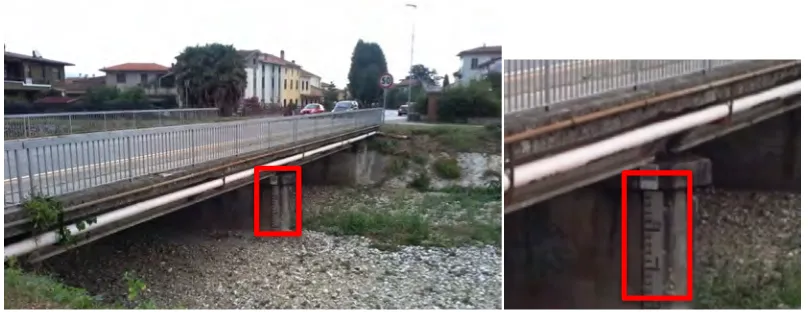
In addition to cost, the use of external contractors for sensor installation can also introduce unforeseen errors when the purpose and use of the sensors / QR codes is not necessarily clear to the contractor. For example, the installation of gauge boards and associated QR codes in the Italian use case resulted in the QR code (to be scanned by a citizen with a smartphone from on the bridge) being situated in a position which was difficult to see and too distant to scan (see Figure 5). Rectifying this error introduced additional costs and delays.
Reputational damage
authorities involved in the WeSenseIt project have long-standing relationships with their local communities spanning far beyond the start of the WeSenseIt project. These relationships have been built slowly and are invaluable with regard to the work that emergency planners conduct with communities. As a result, it is vital that such relationships are protected. Therefore, it was important to demonstrate the reliability of any sensors which involve citizen interaction (either when collecting data or being installed in a location under their control) both in terms of the physical installation and subsequent easy access to the sensor's data (especially important since the observatory's platform is still under development at this early stage of the project). This approach has introduced additional, unexpected delays into the installation schedule.
FUTURE WORK
The WeSenseIt project is currently mid-way through the first formal evaluation of the observatory; indeed the project still has over two and a half years to run. Therefore, much work remains to be done. Of primary importance (both from data-availability and community-impact perspectives) is the completion of the sensor installations. These are on-going in the three use cases and additional sensors will be installed following the analysis of the first evaluation. The data from these sensors (and the citizen generated data from the mobile app and citizen sensors) is aggregated via the WeSenseIt platform. The first version of this platform is already available and being used to store sensor data. Future work will focus on expanding the flexibility of the API in response to data processing needs presented by the visualisation and decision support systems and the modelling / prediction systems.
The layer above the sensors, data and storage platform focuses on the tangible, user-targeted interface to the Citizen Observatory. Preliminary work in this area allows access to raw data; future work will focus on drawing together information from physical sensors, social sensors, hydrological models to present a coherent situational awareness. Research will focus on how to manage, assimilate (and present) the varying degrees of accuracy and reliability inherent in data drawn from professional sensors, low-cost sensors and crowd-sourced reports. Interface styles (amount of data presented, geographical span, temporal span, etc) will be investigated to ensure each user type (citizen, emergency planner, etc) are presented with the information appropriate to their role. Related to this is investigating the issues of data sensitivity and privacy.
For what regards assessing reliability and quality of citizens’ provided information, an evaluation is planned to compare data collected by physical sensors in various locations with information collected and submitted by citizens to analyse differences, gaps and understand how to address those issues.
Additional approaches to citizen engagement will also be investigated to maintain year-round use of the observatory (as opposed to only during flood risk periods).
CONCLUSION
We have presented an overview of the work being conducted as part of the WeSenseIt project. At the heart of this effort is the creation of a citizens’ observatory focussed on water and flood management. Such a citizens’ observatory provides a unique way of engaging the public in the decision-making processes associated with flooding. In WeSenseIt citizens are fully engaged in the collection of qualitative and quantitative data; play an active role in influencing the actions of the local authority and provide peer-to-peer information for their fellow citizens. For the local authority, the benefit is a significant increase in the amount of real-time information available which, when combined with the professional-grade autonomous environmental sensors, provides a much improved situation awareness. Furthermore, the ability to cross-check the status of evolving situations with the degree of flood preparedness for a particular area allows the local authority to better plan how to prioritise staff and assets on the ground. For the citizen, the benefit is the availability of a much richer, up-to-date status of their locality capturing not only environmental data but also information and discussion from their neighbours and fellow citizens.
Proceedings of the 11th International ISCRAM Conference – University Park, Pennsylvania, USA, May 2014
ACKNOWLEDGMENTS
This research was funded by the European Union Seventh Framework Programme FP7/2007-2013 under grant agreement number 308429 (www.wesenseit.eu). We would like to thank the WeSenseIt partners that provided sensors for the case studies, in particular EPFL, STARLAB, AVDANTICSYS.
REFERENCES
1. Becker, M., Mueller, J., Hotho, A., & Stumme, G. (2013). A generic platform for ubiquitous and subjective data. In Proceedings of the 2013 ACM conference on Pervasive and ubiquitous computing adjunct
publication (pp. 1175-1182). ACM
2. Bhattacharjee Y. (2005) Citizen scientists supplement work of Cornell researchers. Science 308: 1402– 1403.)
3. Bonney R, Cooper C, Dickinson J, Kelling S, Phillips T, et al. (2009) Citizen Science: A Developing Tool for Expanding Science Knowledge and Scientific Literacy. BioScience 59: 977–984.
4. Ciravegna, F., Huwald, H., Lanfranchi, V. Wehn de Montalvo, U. (2013). Citizen observatories: The WeSenseIt Vision. Inspire Conference, Florence, 2013.
5. Ciscar J.-C.(editor) (2009) Climate change impacts in Europe: Final report of the PESETA research project. European Commission, Joint Research Centre Institute for Prospective Technological Studies (JRC-IPTS) 6. Donnelly, A., Crowe, O., Regan, E., Begley, S., & Caffarra, A. (2013). The role of citizen science in
monitoring biodiversity in Ireland. International journal of biometeorology, 1-13.
7. Endsley, M. R. (1995) Toward a theory of situation awareness in dynamic systems: Situation awareness. Human factors 37, 1.
8. Goodchild, M. F. (2007) Citizens as sensors: web 2.0 and the volunteering of geographic information. GeoFocus (Editorial) 2: 24-32.
9. Haklay, M. (2013) Citizen Science and volunteered geographic information: Overview and typology of participation. Crowdsourcing Geographic Knowledge. Springer Netherlands. 105-122
10. Kamel Boulos MN, Resch B, Crowley DN, Breslin JG, Sohn G, et al. (2011) Crowdsourcing, citizen sensing and Sensor Web technologies for public and environmental health surveillance and crisis management: trends, OGC standards and application examples. Int J Health Geogr 10: 67.
11. Lanfranchi, V. (2012) Realtime Situation Awareness via Social Media Streams, Demo Session at ISCRAM 2012, Vancouver, Canada.
12. Mazzetti, P., Nativi, S., Santoro, M., & Boldrini, E. (2013). The GEOSS Common Infrastructure for the heavy metal pollution community applications. In E3S Web of Conferences (Vol. 1, p. 18002). EDP Sciences
13. Raddick, M. J., Bracey, G., Gay, P. L., Lintott, C. J., Cardamone, C., Murray, P., Schawinski, K., Szalay, A. S. Vandenberg, J. (2013). Galaxy Zoo: Motivations of Citizen Scientists. arXiv preprint arXiv:1303.6886. 14. Sein, M. K., Henfridsson, O., Puraro, S., Rossi, M., & Lindgren, R. (2011). Action Design Research. MIS
Quarterly , 35 (1), 37–56.
15. Snyder, E. G., Watkins, T. H., Solomon, P. A., Thoma, E. D., Williams, R. W., Hagler, G. S. W., Shelow, D., Hindin, D. A., Kilaru, V. J. and Preuss, P. W. (2013). The Changing Paradigm of Air Pollution Monitoring. Environmental Science & Technology 47(20), 11369-11377