Investigation of Potential Barriers
Restricting Fish Passage into Horseshoe
Lagoon, Burdekin-Haughton
Floodplain, North Queensland
Report No. 07/16
June 2007
Prepared for
Great Barrier Reef Coastal Wetlands Protection Program
Department of Environment & Water
Canberra
Prepared by
Vern Veitch and Damien Burrows
Australian Centre for Tropical Freshwater Research
James Cook University
Townsville, Qld 4811
Phone: 07-47814262
Australian Centre for Tropical Freshwater Research
Executive Summary...i
1.0 INTRODUCTION...1
2.0 METHODS...2
2.1 Site
Description...2
2.2 Fish Sampling………3
2.3 Water Quality Sampling………...3
3.0
RESULTS AND DISCUSSION………..6
3.1 Fish Communities of Horseshoe Lagoon……….6
3.2 Physical Fish Passage Barriers……….7
3.3 Water Quality-Mediated Fish Passage Issues for Horseshoe Lagoon………...8
4.0
CONCLUSIONS AND RECOMMENDATIONS……….10
APPENDIX A
Photographic Images of Horseshoe Lagoon
Australian Centre for Tropical Freshwater Research i
EXECUTIVE SUMMARY
Horseshoe Lagoon is approximately 50 kilometres south-east of Townsville. It is a large (70 hectare) lagoon on the east bank of the Haughton River and is an important component of the Burdekin-Haughton wetlands aggregation. Floodplain lagoons on the Burdekin floodplain are recognised for their importance to ecological values and particularly fishery productivity for the downstream coastal fishery.
Horseshoe Lagoon became degraded in the years leading up to 2003, due to a combination of agricultural development and farm tailwater input altering the normal seasonal hydrology of the lagoon and creating favourable conditions for prolific growth of aquatic weeds. In 2003, most of the aquatic weed was sprayed or mechanically removed from the lagoon and this resulted in rapid water quality improvements but monitoring of fish communities showed that many native fish species seemed unable to recolonise the lagoon. There was speculation that the lagoon had become isolated because of physical barriers but research on other wetlands on the Haughton floodplain raised concerns that there may be water quality barriers that needed to be addressed before fish could migrate.
The Commonwealth Government’s Coastal Wetlands Protection Programme Pilot Programme (CWPP PP) funded an investigation into the reasons why estuarine-breeding fish were not being found in Horseshoe Lagoon, with the focus being on assessing potential fish passage barriers. The entire section of waterway between the estuary and Horseshoe Lagoon was surveyed for potential physical barriers. Monitoring of fish communities and water quality was undertaken on a number of occasions and a timely flood event in February 2007 allowed direct observation of potential physical and water quality barriers to fish migration.
Our investigations have shown that there is a combination of both physical and water quality barriers that may be reducing opportunities for fish migration from the downstream estuaries into Horseshoe Lagoon. The tidal bund at the bottom of the system is not a fish passage barrier. However, in all except major floods, there is an important physical barrier at a culvert on a farm access road ~1km downstream of Horseshoe Lagoon, that cannot be negotiated by native fish species seeking to migrate upstream. Additionally, water quality monitoring found low levels of dissolved oxygen (DO) in areas downstream from Horseshoe Lagoon that both reduce fish passage potential (through avoidance of low DO) and mean that many migrating fish that get caught in the creek system downstream of Horseshoe Lagoon where they may not survive the dry season.
Australian Centre for Tropical Freshwater Research 1
1.0 INTRODUCTION
Horseshoe Lagoon is a large (~70ha), valuable freshwater wetland within the Burdekin-Haughton floodplain aggregation ~50km SE of Townsville. In its natural state, Horseshoe Lagoon had a seasonal hydrology with highly variable water levels and no clearly defined outlet. The lagoon connects to the downstream estuary initially via an artificially excavated channel across a grazing paddock created to assist in draining excess water from the lagoon, which then forms into a well-defined creek channel several kilometres long. It then spills out onto a floodplain with shallow freshwater and estuarine wetlands. Horseshoe Lagoon has long been considered a major regional fish habitat and estuarine-breeding species such as barramundi, were common there. Initial development of the area comprised mainly cattle grazing which maintained similar hydrology as the pre-European condition. However, much of the current land use is intensive irrigated agriculture, primarily sugar cane. This has changed the hydrology of the area, including sustained high water levels in the lagoon and associated elevated nutrient loading. These changes, and the removal of grazing in many areas, has allowed introduced pasture grasses such as hymenachne, and floating weeds such as water hyacinth, to become serious weeds. In addition, a downstream farm access road has included the construction of a culvert across the downstream channel and this is a major barrier to fish migration in all but large flood events.
Until 2003, Horseshoe Lagoon had become progressively impacted by aquatic weeds and its previous role as a fish habitat area for marine migratory species had been compromised from the resulting poor water quality. Since 2003, improved management of Horseshoe Lagoon, supported by the Burdekin Shire Council, Sunwater and local landholders, and with injection of funds through the National Heritage Trust, has removed most of the instream weed infestations. Horseshoe Lagoon now has an established on-site management regime that minimises adverse impacts on water quality and habitat and benefits natural faunal communities. Whilst there are ongoing riparian terrestrial weed issues, these are being progressively addressed as resources become available.
Australian Centre for Tropical Freshwater Research 2
2.0 METHODS
2.1 Site Description
Horseshoe Lagoon is a large off-stream lagoon of approximately 70 hectares, on the right bank of the Haughton River approximately 25 km upstream from the river’s mouth. The lagoon is a declared conservation park and has benefited from an improved management programme implemented by Burdekin Shire Council with funding assistance from Sunwater, landholders and various government funding sources to manage aquatic weeds.
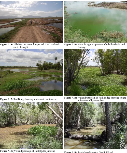
Horseshoe Lagoon receives irrigation tailwater from farms to the south and east of the lagoon and in large flood events receives bank overflow from the Haughton River. The tail water inputs ensure the lagoon is usually at a full water level and often overflowing into downstream environments. Riparian vegetation around the lagoon’s margin is sparse, mostly being introduced para grass and hymenachne. A few remnant melaleuca and Leichhardt trees survive on the banks although some of these are now severely stressed, apparently by elevated ground water levels adjacent to the lagoon. Water exits Horseshoe Lagoon via a constructed outlet (Figure A2), although during large flood events, it flows out across a broader area. This outlet is lined with hymenachne and during floods, this hymenachne can be ripped out by floodwaters, exacerbating erosion of the outlet channel. This hymenachne-lined outlet channel continues for about 1km before crossing a road (at Croc crossing – Figures A6 - A11, so named because a crocodile was encountered there during one sampling visit) and continuing downstream. After this point, the channel takes on a more natural creek-like form and flows for several kilometres through forested wetlands, including at various points, dense melaleuca, pandanus and mixed tree stands (see Figure A4 and A16-A18 for examples). This provides valuable permanent wetland habitat, although the waters there appear to be low in dissolved oxygen, also having a high organic and leaf litter standing crop and often little shading. At the rail bridge, this creek system broadens out again into a shallow wetland with no riparian vegetation (Figure A15), subject to open sunlight which appears to drive a eutrophic situation with excessive diel dissolved oxygen variation. There is also a lot of water hyacinth present at this rail bridge site (Figure A16), which further affects water quality. Downstream of the rail bridge, the water either backs up against the tidal bund wall (Figure A12 - A13) or dries up later in the year.
Since at least 1998, the water surface of Horseshoe Lagoon has been largely covered by floating exotic weeds. Initially, this was mostly salvinia (Salvinia molesta) and water lettuce (Pistia stratiotes), but more recently, water hyacinth (Eichhornnia crassipes) has become dominant and the surface of the floating weed mat has been secondarily colonized in many places by a variety of grasses, vines and sedges. Funding was obtained from the Burdekin Dry Tropics Board to clear these floating weeds from the lagoon in 2003/4 using the Burdekin Shire Council’s floating aquatic weed harvester. Follow-up maintenance of water hyacinth mats has occurred as part of an ongoing maintenance programme. The water quality and limnology of Horseshoe Lagoon was studied by ACTFR in 2004 and reported as part of a catchment-wide study reported in Loong et al. (2005). Dowe (2004) briefly assessed the riparian vegetation of Horseshoe Lagoon, using the Tropical Rapid Appraisal of Riparian Condition (TRARC) methodology, but the site was dominated by pasture grasses with few trees to be found and thus was given the third lowest TRARC score of the 207 sites assessed throughout the Burdekin catchment. However, the lagoon naturally has few trees and the TRARC methodology is not entirely suitable for a wetland of this type.
Australian Centre for Tropical Freshwater Research 3 2.2 Fish Sampling
Fish sampling involved visual inspection (where the water was clear and shallow), the use of dip and cast nest and electrofishing using a Smith-Root Model 12-B backpack electrofisher. Electrofishing was also undertaken in Horseshoe Lagoon and at the rail bridge lagoon using a boat-mounted 2.5GPP Smith-Root electrofisher.
Visual observations were undertaken along with water quality sampling at all locations on each visit. Dip and cast netting was used in areas where fish had become stranded on receding flood waters and were easily netted and in small areas close to stream banks where no snags or weeds impeded the netting.
Backpack electrofishing was undertaken at three sites (below Croc Crossing, at Gandini Road and upstream from the Rail bridge under a melaleuca forest) in May 2007 with dip and cast netting done upstream from the rail bridge, at Gandini Road and downstream from Croc Crossing on 23 January and 29 March 2007. Backpack electrofishing was undertaken on 31 May 2007 and consisted of a series of bursts of electricity for 20 seconds in a suitable microhabitat then moving to the next microhabitat and repeating the procedure. 15 minutes electrofishing time was recorded at Croc Crossing and upstream from the rail bridge while 10 minutes on-time was recorded at the Gandini Road site.
Boat mounted electrofishing was undertaken at Horseshoe Lagoon on two occasions with ten separate three minute shots spread through representative habitat throughout the lagoon on the first visit on 24 January 2007 and twenty separate five minute shots on the second visit on 3-4 April 2007. Each shot consisted of 20-30 seconds bursts separated by 20-30 seconds to capture stunned fish and minimise “shock fright”. Similar methodology was used on the lagoon upstream of the rail bridge with ten shots applied on the first visit on 28 March 2007, but was restricted to five shots on the second visit on 12 June 2007, due to an expanding weed infestation.
2.3 Water Quality Sampling
Investigation of potential water quality barriers to fish passage involved assessing water quality along the flow path from Horseshoe Lagoon before, during and after large flood events (full data records are at Appendix B). Water quality parameters investigated were dissolved oxygen (DO), pH, temperature and conductivity were taken at 20cm depth, although DO was of greatest interest as the most relevant indicator of a water quality barrier to fish migration. Water quality was investigated on 12 occasions with 11 visits occurring between 1100hrs and 1500 hours but with one visit starting at 0530 to capture data when DO was likely to be at its minimum. Two trips in January 2007 visited sites as a reconnaissance to identify the best accessible sites during flood events. For the remaining 10 trips, spread over three months from February to May 2007, water quality was assessed at Horseshoe Lagoon itself and four sites (Table 1) along the flow path downstream of Horseshoe Lagoon, using field water quality meters calibrated prior to each trip. A map of the sites is shown in Figure 1 and photos in Figures A3 to A18. On a number of trips, access could not be gained to some sites because of safety considerations associated with flood waters. None of the sites could be accessed at the peak of the February 2007 floods as the Bruce Highway from Townsville was blocked by police.
The critical sites proved to be Horseshoe Lagoon as a background site, Croc Crossing and adjacent to the Gandini Road/Hodel Road intersection. Croc Crossing was chosen as water leaving Horseshoe Lagoon flows through a narrow channel before entering a shallow wetland just above Croc Crossing. The area is infested with pasture grasses including para grass and hymenachne and is relatively shallow, therefore having a high surface area to volume ratio, a large volume of organic matter and therefore high potential for oxygen depletion.
Australian Centre for Tropical Freshwater Research 4 flows and the presence of crocodiles, this was not possible during the flow event monitored here. Although diel DO logging would provide more information, because we are not assessing ecosystem health, but comparing between locations at a similar time of day and during the time of day when DO is normally expected to be at or near its maximum, the current sampling programme provides the indicative information we require at this stage.
Table 1 Details of Sites Used in this Study
Site No. Site Name Latitude Longitude
A Horseshoe Lagoon 19.5453ºS 147.1192ºE
1 Croc Crossing 19.5318ºS 147.1231ºE
2 Gandini Road 19.5223ºS 147.1284ºE
3 Rail Bridge 19.5151ºS 147.1394ºE
4 Upstream side of tidal
Australian Centre for Tropical Freshwater Research 6
3.0
RESULTS AND DISCUSSION
3.1 Fish Communities of Horseshoe Lagoon
Prior to 2003, Horseshoe Lagoon was covered by floating aquatic weeds, primarily water hyacinth. Fish surveys were not possible but from our previous work on fish and dissolved oxygen levels under floating weed mats on lagoons in the Burdekin-Haughton floodplain (eg, Perna 2003a,b, Perna and Burrows 2005), we are confident that water quality under the weed mat would have restricted fish communities to a few species able to access the very thin oxygenated layer at the surface in areas where there may have been small gaps in the weed.
[image:9.612.58.566.347.735.2]In addition to the fish surveys conducted in 2007, data from two previous surveys are relevant. After the weed was harvested in 2003, ACTFR undertook fish surveys on behalf of the Haughton River Catchment Committee at a number of sites in the Haughton catchment, including Horseshoe Lagoon, to assess fish habitat values and management issues, in which the weed and fish passage issues facing Horseshoe Lagoon were flagged as high priorities (Burrows and Perna 2004). Horseshoe Lagoon was surveyed on 8 June 2004 for this project and again on 9 August 2005 for the CWPP PP. The June 2004 survey involved 9 two-minute electrofishing shots spread over various parts of the lagoon, the setting of a single 2-inch gill net for two hours and four 20cm by 20cm by 50cm baited traps left for two hours. The August 2005 survey was specifically focused on surveying for barramundi and thus involved fairly continuous electrofishing for a total time of four hours. The fish species found from all of the above surveys are shown in Table 2.
Table 2 Results of ACTFR Fish Surveys in Horseshoe Lagoon
Species Common Name
Haughton Catchment
Study 8 Jun 2004
Horseshoe Lagoon GBRCWPP 9 Aug 2005
Croc Crossing Jan, Mar &
May 2007
Rail Bridge Jan, Mar, May & June
2007
Horseshoe Lagoon 24 Jan 07
Horseshoe Lagoon 3&4 Apr
2007
Ambassis agrammus Glass perch P P P P
Amniataba percoides Barred grunter P P P
Anguilla reinhardtii Long-finned eel P P
Ariopsis graeffei Blue catfish P P
Craterocephalus stercusmuscarum
Fly-specked hardyhead
P P P P
Gambusia holbrooki Mosquitofish -exotic
P P P P
Giurus margaritacea Snakehead gudgeon P P
Glossamia aprion Mouth almighty P P P P
Hypseleotris sp1 Midgley’s carp gudgeon
P P
Hypseleotris compressa Empire gudgeon P P
Hypseleotri klunzingeri P
Lates calcarifer Barramundi P P P P
Leiopotherapon unicolor Spangled perch P P P P P
Megalops cyprinoides Tarpon P P P
Melanotaenia splendida Eastern rainbowfish P P P P
Mugil cephalus Sea mullet P
Nematolosa erebi Bony bream P P P P
Neosilurus ater Black catfish P P
Oxyeleotris lineolata Sleepy cod P P P P
Prionobutis microps Small-eyed sleeper P
Redigobius bikolanus Speckled goby P
Strongylura krefftii Freshwater Longtom P
Toxotes chatareus Archer fish P P
Total No. Native Species 7 9 6 8 13 20
Australian Centre for Tropical Freshwater Research 7 The surveys show an increase in the number of species accessing Horseshoe Lagoon since weeds were removed from the lagoon. A total of 23 fish species have been recorded from the Horseshoe Lagoon system in recent years, although one of these is the exotic mosquitofish which can be found throughout the entire system. Only two species – the sea mullet and longtom were recorded downstream of, but not within, Horseshoe Lagoon itself (Table 2). Sea mullet in particular need to migrate upstream from downstream estuarine areas to access Horseshoe Lagoon. Barramundi have been stocked into Horseshoe Lagoon by the Twin Cities Fish Stocking Association, confusing the issue of whether the barramundi caught in our surveys are stocked fish or whether they recruited there from the estuary. Early surveys in Horseshoe Lagoon in 2004/05 only caught juveniles that would have been from the stocking, indicating that barramundi are not, or are rarely, recruiting to Horseshoe Lagoon.
A total of eight fish species were found at the rail bridge site including sea mullet, barramundi and juvenile tarpon, all estuarine-breeding species and six species at Croc Crossing,. Whilst these two sites had reasonable fish assemblages present, the only fish found at the Gandini Road site were the exotic mosquitofish. Dissolved oxygen levels at this site were generally low and although some fish obviously move through or around the site during flood events the water quality may not be suitable for other fish species. Barramundi and mullet found at the rail bridge were not sighted below Croc Crossing although tarpon were observed there.
Surveys by ACTFR in 2004 and 2005, used fish tags supplied by the Burdekin Fish Restocking Association to tag all barramundi caught in Horseshoe Lagoon, with the tag details reported to AUSTAG – the national fish tagging system. One barramundi was tagged on 8 July 2004, four on 2 February 2005 and 11 on 9 August 2005. A 545mm (Total Length) barramundi tagged in Horseshoe Lagoon on 2 March 2005, was later reported to be caught in a tidal reach of Sheep Station Creek on 2 Feb 2007 at a total length of 805mm showing that fish can migrate downstream from Horseshoe Lagoon in flood events.
There have been two important flood events since the weeds were removed. The wet seasons of 2004/05 and 2006/07 both had heavy rain in the Haughton catchment including the floodplain areas containing Horseshoe Lagoon. The February 2007 flood had large overbank flows from the Haughton River and this may have provided a source of fish recruitment from the river. Additionally, extensive flooding downstream provided a small window of opportunity for fish in estuarine environments to migrate upstream while dissolved oxygen levels were adequate and physical barriers were flooded out.
3.2 Physical Fish Passage Barriers
Initial field inspection of the entire length of the flow path downstream of Horseshoe Lagoon revealed two potential physical fish passage barriers in the system. The first is a low bund wall (Figures A12-A13), constructed at the freshwater-estuarine interface to keep saltwater out of the adjoining grazing paddock. The second was a culvert built as part of a road access to a cane farm about 1km downstream of Horseshoe Lagoon. An aerial photo of this location is provided in Figure A3 and on-ground photos in Figures A6-A11.
The bund wall is very low and has a breach that makes passage over this structure even easier (Figure A12-A13). The bund wall and the whole area either side of the bund wall readily drowns out during flow events and for extended periods. Thus, we did not consider this to be creating any fish passage problems during elevated flows. Additionally, sampling upstream of this site at the rail bridge showed that fish are migrating up from tidal areas, at least to that point, during flow events.
The culvert on the cane farm access road is estimated to be about 2.5 m high and creates a large head loss at all but the highest flows when it temporarily drowns out (Figure A9 taken on 4 Feb 2007). Thus opportunities for fish passage are limited to a brief window of opportunity.
Australian Centre for Tropical Freshwater Research 8 would be found. Barramundi found in Horseshoe Lagoon however appear to be stocked fish either stocked directly into Horseshoe Lagoon or carried in flood waters from the Haughton River (Figure A1). No small fish from downstream estuarine environments were positively identified. The most likely causes for this are either physical inability to negotiate the culvert at Croc Crossing, immediately downstream of Horseshoe Lagoon, or poor water quality during flow events turning fish away from swimming upstream. After detailed examination of the culvert during several flood events and its construction in general, we believe that it is a likely obstruction to fish passage in all except very large floods where it is drowned out. In recent times, only the February 2007 has been big enough to flood out the culvert but that aside, our general observations of the landscape raised concerns about the potential for water quality issues to be preventing migration.
3.3 Water Quality-Mediated Fish Passage Issues for Horseshoe Lagoon
Initial water quality readings in January 2007 prior to the wet season starting, showed DO levels to be depleted even in the middle of the day. DO readings at the rail bridge (18.7%) and the tidal barrier (26.5%) on 11 January 2007 were suggestive of chronic levels of oxygen depletion that can impact on fish populations. Readings at Horseshoe Lagoon (49%) and Croc Crossing (53.8%) in the late afternoon on 23 January 2007 are probably representative of DO levels in this type of wetland after a very hot day (water temperature was 33.5ºC at Croc Crossing at 1515 hrs).
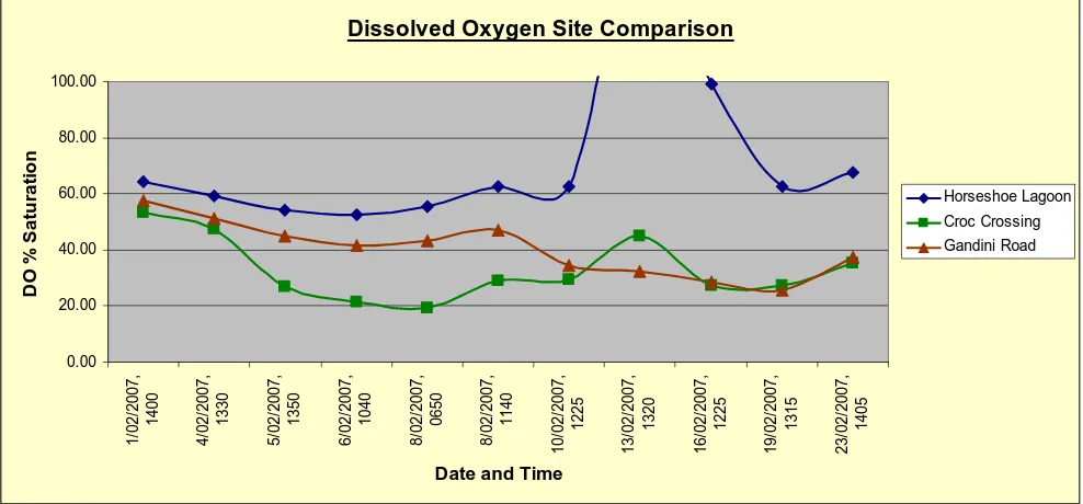
The graph at Figure 2 shows an important trend in DO levels from Horseshoe Lagoon to Gandini Road regardless of the background reading. Generally, DO levels are moderate to high in Horseshoe Lagoon but drop significantly above Croc Crossing before showing some recovery by the time they reach Gandini Road where the waterway is narrow but heavily shaded. The only exception to this strong trend was on 13 February where water flow from a small rain event following the flood was sufficient to hide the effect due to increased velocity along the length of the stream. Between Croc Crossing and Gandini Road, there is more turbulence in the now deeper and more channelised flow path to oxygenate the water.
Dissolved Oxygen Site Comparison
0.00 20.00 40.00 60.00 80.00 100.00 1/ 0 2 /200 7, 1400 4/ 0 2 /200 7, 1330 5/ 0 2 /200 7, 1350 6/ 0 2 /200 7, 1040 8/ 0 2 /200 7, 0650 8/ 0 2 /200 7, 1140 10/ 0 2 /200 7, 1 225 13/ 0 2 /200 7, 1 320 16/ 0 2 /200 7, 1 225 19/ 0 2 /200 7, 1 315 23/ 0 2 /200 7, 1 405
Date and Time
[image:11.612.59.553.415.645.2]D O % S a tu ra ti o n Horseshoe Lagoon Croc Crossing Gandini Road
Figure 2 Water Quality Data from Horseshoe Lagoon, Croc Crossing and Gandini Road during February 2007.
Site 1 = Horseshoe Lagoon adjacent to Hodel Road Site 2 = Croc Crossing at culvert access to cane farm
Site 3 = Shaded reach opposite Gandini Road/Hodel Road intersection
Australian Centre for Tropical Freshwater Research 9 feeding a floating aquatic weed infestation, and then up to the base of Croc Culvert where they must wait for the right conditions (a flood out) before entering the canal that drains Horseshoe Lagoon. From the water quality data and field observations during the 2007 flood event, it appears that the water at Croc Crossing has such a low DO content, that the fish would appear unlikely to swim up the flow path that leads to the culvert at most times. This result is borne out by the limited number of migrating fish observed below the culvert and the questionable recruitment of catadromous fish into Horseshoe Lagoon prior and subsequent to the large 2007 flood event. Thus, the low DO levels of flow water at Croc Crossing would need to improve to encourage fish passage.
There are two aspects to the water quality issues downstream of Horseshoe Lagoon. The first is that flood flow waters generally have insufficient oxygen to facilitate upstream fish passage and the second is that ambient water quality within the creek channels downstream of the lagoon are also very poor for the survival of DO-sensitive fish species. The cause of low DO during the tail of the flood hydrograph is most likely deoxygenation of the water as it passes over the cattle paddock and through the hymenachne-lined and water hyacinth infested channel above Croc Crossing. Where the overlying water is deep or flowing fast (such as during peak flood flows), the effect is lessened, but when shallow and/or slower flowing, it is heightened. During strong flows from large flood events, the residence time of water on the wetland is reduced and fish may have the opportunity to move upstream, but this only occurs for brief periods of strong flow on rare occasions. This situation is not easily remedied. Control of the hymenachne may assist, as may deepening of the channel to reduce the amount of contact between the soil and the overlying water column. Encouraging turbulence through the use of in-stream structures placed in the flow path may also reduce deoxygenation.
This scenario is very similar to the situation described for fish passage from Reed Beds Lagoon to Healeys Lagoon on the left bank of the Haughton River (Burrows et al. 2006, Veitch and Burrows 2006) where water exiting Healeys Lagoon was deoxygenated as it flowed across a paddock, creating a water quality barrier to upstream fish migration. For Healeys Lagoon, the water was almost completely deoxygenated by the time it reached Reed Beds Lagoon (the source of recruits) whereas the water reaching Croc Crossing has some oxygen. However, this appears insufficient to effect fish passage. Butler and Burrows (2007) studied the tolerance of 14 tropical Australian freshwater fish species to low dissolved oxygen and recommended acute effect trigger values of 30% and 16% saturation as being the point at which the oxygen intake of DO-sensitive species and barramundi respectively, cannot keep up with their requirements, and their survival chances are greatly diminished (Butler and Burrows, 2007). Under such conditions, they cannot exert extra energy to swim upstream against currents. The dissolved oxygen levels at Croc Crossing remained below 30% saturation on most days monitored, although they were always above 16% sat. However, it must be remembered that these readings were taken in the middle of the day when DO values are expected to be at their highest. The only days when it was potentially high enough to permit fish passage where closer to the flood peak when flow rates were very high and the water velocity at Croc Crossing may have restricted fish passage.
Australian Centre for Tropical Freshwater Research 10
4.0 CONCLUSIONS
AND
RECOMMENDATIONS
The results of several fish surveys show that Horseshoe Lagoon has some fish passage issues and that its fish diversity and productivity is less than what would be expected of a major floodplain lagoon of its size, location and condition. There is a physical barrier preventing fish passage (the culvert at Croc Crossing) at all but the peak of flood events. Additionally, the quality of water at Croc Crossing, specifically the dissolved oxygen saturation, may be contributing to the problem. The DO content of the water is sufficient when it leaves Horseshoe Lagoon but low by the time it arrives at Croc Crossing, a critical point for potential fish recruits. Water exiting Horseshoe Lagoon travels across a cattle grazing paddock and/or through a shallow hymenachne-lined channel, both of which deoxygenate the water due to the oxygen demand in the soil and amongst the dense hymenachne stands. Where the overlying water is deep or flowing fast (such as during peak flood flows), the effect is lessened, but when shallow and/or flowing slower, it is heightened.
Restoration of good fish passage requires that pathways for fish passage remain viable more frequently and for longer periods. One means of achieving this in the current situation would be to construct a causeway with a downstream rock ramp at Croc Crossing to enhance fish migration. A rock ramp will allow fish to migrate in low flows at the start and finish of a flood event rather than the peak. A funding application to construct a fish ramp at Croc Crossing, in conjunction with the Burdekin Shire Council, has been submitted to the Australian Government’s Recreational Fishing Grants Fund. The design of this rock ramp was investigated via a site visit with Tim Marsden, a fish biologist with experience in fishway design, from the Queensland Department of Primary Industries and Fisheries on 4 May 2007. Additional funding should be sought to ensure ongoing management of weeds along the stream joining Horseshoe Lagoon to the estuarine environment and undertake monitoring of water quality and fish passage resulting from improved management of the stream. Due to the extent of the connectivity problem that is often not easily apparent, information from this project should be important to other floodplain projects in the Queensland Dry Tropics region.
Water quality, especially in the reach between the rail bridge and Croc Crossing during the dry season, is particularly poor and migrating fish that get caught in this reach are unlikely to survive the dry season there. This can be partly addressed by mechanical removal of in-stream emergent and floating weeds along the length of the watercourse combined with an ongoing spraying programme to kill remaining weeds and prevent major re-infestations. Funding sources must be identified to ensure ongoing management is guaranteed.
Previous fish surveys of Horseshoe Lagoon, including after the 2005 flood event, have failed to find evidence of significant fish passage into the lagoon. The February 2007 flood was at least as big. To date no evidence of significant fish recruitment has been found either. However, many migrating fish are quite small and it would be worth investigating the fish community of Horseshoe Lagoon later in the dry season, after any fish that may have migrated there have had time to grow larger and may be more readily caught.
Australian Centre for Tropical Freshwater Research 11
2.0 REFERENCES
Burrows, D.W. and Perna, C. 2004. Assessment of Fish Communities, Fish Habitat and Their Associated Management Issues in the Haughton River Catchment, Northern Queensland. Report No. 04/17 Australian Centre for Tropical Freshwater Research, James Cook University, Townsville.
Burrows, D.W., Veitch, V., Loong, D., Perna, C. and Butler, B. 2006. Monitoring of the Health and Fish Passage Issues of Healey’s Lagoon Following Removal of an Extensive Mat of Floating Aquatic Weeds. Report No. 06/11 Australian Centre for Tropical Freshwater Research, James Cook University, Townsville.
Butler, B. and Burrows, D.W. 2007. Dissolved Oxygen Guidelines for Freshwater Habitats of Northern Australia. Report No. 07/07 Australian Centre for Tropical Freshwater Research, James Cook University, Townsville.
Dowe, J.2004. Riparian Vegetation in the Burdekin River and Haughton River/Barratta Creek Catchment. Report No. 04/14. Australian Centre for Tropical Freshwater Research, James Cook University, Townsville.
Loong, D., Butler, B., Burrows, D., Davis, A and Faithful, J. 2005. Limnological Assessment and Benchmarking of Key Sentinel Wetlands in the Burdekin Catchment. Report to the Burdekin Dry Tropics Board as part of the National Action Plan for Salinity and Water Quality for the Burdekin Catchment: Priority Action Project No. 4. ACTFR Report No.05/09 Australian Centre for Tropical Freshwater Research, James Cook University, Townsville.
Perna, C. 2003a. Fish Habitat Assessment and Rehabilitation in the Burdekin Delta Distributory Streams. Report No. 03/22 Australian Centre for Tropical Freshwater Research, James Cook University, Townsville.
Perna, C., 2003b. Impacts of Agriculture and Restoration of the Habitat Values, Water Quality and Fish Assemblages of a Tropical Floodplain. Masters of Science Thesis, School of Tropical Biology, James Cook University, Townsville, Australia, 144pp.
Australian Centre for Tropical Freshwater Research A-1
APPENDIX A
Australian Centre for Tropical Freshwater Research A-2
[image:16.612.57.573.66.689.2]Figure A1: Barramundi caught in Horseshoe Lagoon. Figure A2: Outlet from Horseshoe Lagoon.
Figure A3: Croc Crossing and upstream wetland. Figure A4: Gandini Road is left of the centre left of this image.
Figure A5: Tidal Barrier at boundary of estuary. Figure A6: Croc Crossing in base flow condition.
Croc Crossing
Australian Centre for Tropical Freshwater Research A-3
Figure A7: Croc Crossing in low flow conditions on 5 Feb 2007.
Figure A8: Looking upstream from Croc Crossing. Note the weed infestation.
Figure A9: Croc Crossing almost flooded out on 4 Feb 2007. Figure A10: Croc Culvert looking downstream after the flood peak on 4 Feb 2007.
Figure A11: Croc Crossing looking downstream in low flow conditions.
[image:17.612.56.578.137.695.2]Australian Centre for Tropical Freshwater Research A-4
Figure A13: Tidal Barrier in no flow period. Tidal wetlands are to the right.
Figure A14: Water in lagoon upstream of tidal barrier in mid January.
Figure A15: Rail Bridge looking upstream to south-west. Figure A16: Wetland upstream of Rail Bridge showing severe infestation of hymenachne
Figure A17: Wetland upstream of Rail Bridge showing
[image:18.612.56.573.52.673.2]Australian Centre for Tropical Freshwater Research B-1
APPENDIX B
Australian Centre for Tropical Freshwater Research B-2 11-Jan-07 Rail Bridge Tidal Barrier 23-Jan-07
Horseshoe Lago
on
Croc Crossing Tidal Barrier
1-Feb
-07
Horseshoe Lago
on
Croc Crossing Gandini Road
4-Feb
-07
Horseshoe Lago
on
Croc Crossing Gandini Road
5-Feb
-07
Horseshoe Lago
on
Croc Crossing Gandini Road
Time sunny 1215 1130 sunny 1545 1515 1445 cloudy 1440 1425 1400 cloudy 1405 1350 1330 cloudy 1425 1410 1350
Temp °C 29.03 32.14 27.21 33.53 28.74 24.21 24.00 24.60 24.53 25.40 24.80 25.14 25.50 24.88
pH 7.04 7.04 7.07 6.79 6.42 6.71 6.98 6.87 6.85 6.84 6.67 6.68
Cond µs/cm 581 4489 296 223 321 116 40 151 60 64 66 74 87 112
DO % sat 18.70 26.50 49.00 53.80 32.60 64.10 53.40 57.70 59.10 47.40 51.20 54.30 26.70 44.80
DO mg/L 1.44 1.90 3.80 3.78 2.50 5.37 4.50 4.76 4.85 3.88 4.24 4.41 2.19 3.79
6-Feb
-07
Horseshoe Lago
on
Croc Crossing Gandini Road
8/02/2007 (Morni
ng)
Horseshoe Lago
on
Croc Crossing Gandini Road
8/02/2007 (Midd
a
y)
Horseshoe Lago
on
Croc Crossing Gandini Road 10-Feb
-07
Horseshoe Lago
on
Croc Crossing Gandini Road 13-Feb
-07
Horseshoe Lago
on
Croc Crossing Gandini Road
Time cloudy 1145 1108 1040 cloudy 650 640 625 1140 1120 1105 sunny 1300 1240 1225
sunny &
hot 1345 1330 1320
Temp °C 26.30 25.10 24.63 23.16 22.34 22.95 24.54 23.31 22.74 30.67 30.95 28.30 37.65 33.60 30.08
pH 6.84 6.70 6.70 6.96 9.84 6.80 6.77 6.76 6.46 7.07 6.72 6.74 8.79 6.85 6.81
Cond µs/cm 87 103 172 100 122 169 102 108 141 116 117 221 116 118 280
DO % sat 52.70 21.40 41.80 55.30 19.50 43.10 62.8 29.1 47.1 62.50 29.50 34.30 154.20 45.10 32.40
DO mg/L 4.22 1.77 3.46 4.72 1.68 3.71 5.23 2.47 4.05 4.66 2.14 2.64 10.24 3.23 2.36
16-Feb
-07
Horseshoe Lago
on
Croc Crossing Gandini Road 19-Feb
-07
Horseshoe Lago
on
Croc Crossing Gandini Road 23-Feb
-07
Horseshoe Lago
on
Croc Crossing Gandini Road Rail Bridge Tidal Barrier
Time cloudy 1300 1240 1225 cloudy 1345 1335 1315
cloudy &
rain 1445 1415 1405 1345 1305
Temp °C 33.34 31.75 28.85 28.12 27.30 27.14 27.45 26.70 25.94 26.93 26.96
pH 7.93 6.80 6.76 7.12 7.26 7.07 7.53 7.37 7.31 7.38 7.13
Cond µs/cm 112 115 294 112 120 331 126 116 383 538 466
DO % sat 99.30 27.20 28.40 62.80 27.40 25.50 67.70 35.20 37.60 47.70 81.50
[image:20.612.59.773.64.546.2]