Proceedings of the SURVEYING & SPATIAL SCIENCES BIENNIAL CONFERENCE 2011 21-25 November 2011, Wellington, New Zealand
317
Assessing Spatial Information Access, Use and Sharing for Catchment
Management in Australia
Dev Raj Paudyal, Kevin McDougall, Armando Apan
University of Southern Queensland Australian Centre for Sustainable Catchments
Toowoomba, Australia
[email protected]; [email protected], [email protected]
ABSTRACT
Spatial data plays an important role in many social, environmental, economic and political decisions and is increasingly acknowledged as a national resource essential for sustainable development. One of the potential areas where spatial data can make a positive impact is for improved decision making to support catchment management. Reliable spatial data infrastructure (SDI) is needed to record the environmental, social and economic dimensions of catchment management. By building an appropriate SDI, disparate spatial data can be accessed and utilised to facilitate the exchange and sharing of spatial data between stakeholders across catchment communities. The aim of this paper is to identify the factors/variables contributing to spatial information access, sharing and use across catchment management areas and evaluate the current status of spatial information access, sharing and use among Australian states from a catchment management authority perspective. A survey method was used to collect primary data from 56 regional Natural Resource Management (NRM) bodies responsible for catchment management in Australia. Descriptive statistics method was used to show the similarities and differences among Australian states. The key factors which influence sharing and access to spatial information are also explored. We found there is significant for spatial information access, use and sharing to contribute to SDI development.
KEYWORDS: catchment management, natural resource management, spatial information, spatial data infrastructure
1 INTRODUCTION
big drivers are the easily accessible spatial products like Google Earth and hand-held navigation systems which is easily accessible by community and grass-root groups (Folger, 2011).
Spatial data infrastructure is an infrastructure for sharing and use of geospatial information (UN Geospatial Information Working Group, 2007). SDI can facilitate access to the spatial data and services through improving the existing complex and multi-stakeholder decision-making process (Feeney, 2003; McDougall and Rajabifard, 2007). Moreover, it can facilitate (and coordinate) the exchange and sharing of spatial data between stakeholders within the geo-information (GI) community. By building an appropriate SDI, disparate spatial data can be accessed and utilised to facilitate the exchange and sharing of spatial data between stakeholders across catchment communities.
In Australia, all three levels of government play an important role for sustainable catchment outcomes. The Commonwealth Government provides the policy and economic framework and support for intergovernmental coordination (The Parliament of the Commonwealth of Australia, 2002). State and territory governments have the legislated responsibility for natural resource management within their boundaries. Catchment management agencies/regional NRM bodies develop, advise and co-ordinate the implementation of catchment strategies and action plans to achieve sustainable catchment outcomes. Many initiatives have commenced for natural resource information access and sharing at different levels, with spatial information being just one of the components of natural resource information. At the national level, the Australian Natural Resource Information Infrastructure (ANRII) was initiated to facilitate the access and sharing of natural resource information. As the state agencies are the custodians of spatial information, it is important to understand their role with respect to spatial information access, use and sharing. The concept of spatial data infrastructure is already well established, however its effectiveness for the management of spatial information which cross administrative boundaries has been limited (Paudyal et al. 2009). Natural resource information does not understand the artificial jurisdictional boundaries that exist across natural catchments and landscapes.
The aim of this paper is to identify the factors/variables contributing towards spatial information access, sharing and use across catchment management areas and assess the current status of spatial information access, sharing and use among Australian states from a NRM perspective. A survey was distributed to the 56 regional NRM bodies/catchment management authorities (CMAs) across Australia to assess various dimensions of spatial information sharing and access. Further, this paper explores the key factors for developing spatial data infrastructure for better catchment outcomes. The first part of the paper provides an introduction to catchment management in Australia and the importance of spatial information and spatial data infrastructure (SDI) to achieve sustainable catchment outcomes. The primary data collection methods and survey areas are then described. Finally, the paper summarises the findings from questionnaire and comments on key factors which influence spatial data access, use and sharing in catchment management.
2 CATCHMENT MANAGEMENT IN AUSTRALIA
2.1 Historical Perspectives
319
The recognition of the existence of a significant problem requiring action at a national level led to a series of targeted legislative interventions and activities by national and state governments. The philosophy of catchment management became more comprehensive and state government organisations embraced community-government partnership for sustainable management of natural resources on a catchment basis. The two state agencies particularly concerned with catchment management were those charged with soil conservation and water resources management (Laut et al., 1989). The catchment management approach has enjoyed widespread community support since 1990. The current approach to catchment management relies upon the mix of the three tiers of government and various community initiatives. All three levels of government play an important role; however state government agencies has major role working closely with catchment management authorities for natural resource management.
2.2 Catchment Management Arrangements in States and Territories
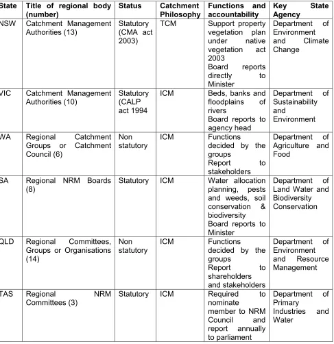
[image:3.595.86.402.365.636.2]Catchment-based management is the approach used for land and water resource management in Australian states and territories (The Parliament of the Commonwealth of Australia, 2002). This management approach is implemented through the creation of partnerships between the different levels of government, community groups, industry groups and academia. All states/territories have some form of catchment management authorities or natural resource management groups under their jurisdiction. There are 56 regional NRM bodies/CMAs which are responsible for catchment management in Australia as shown in Figure 1.
Figure 1: Regional NRM Bodies/Catchment Management Authorities showing the boundary
either statutory (NSW, SA and VIC) or non-statutory (community based) (WA, QLD, TAS). The Territory models are evolving towards independent boards but are still heavily dependent on Territory government structures and processes. There is also inconsistency between states in the name given to the regional NRM bodies. They are termed catchment management authorities in NSW and VIC, Catchment Councils in WA, Natural Resource Management Boards in South Australia, Regional NRM Groups in Queensland and Regional committees in Tasmania(Table 1).
Table 1: State NRM framework characteristics modified from (Pannell et al., 2008)
State Title of regional body (number)
Status Catchment Philosophy
Functions and accountability
Key State
Agency
NSW Catchment Management Authorities (13)
Statutory (CMA act 2003)
TCM Support property vegetation plan under native vegetation act 2003
Board reports directly to Minister
Department of Environment and Climate Change
VIC Catchment Management Authorities (10)
Statutory (CALP act 1994
ICM Beds, banks and floodplains of rivers
Board reports to agency head
Department of Sustainability and
Environment
WA Regional Catchment Groups or Catchment Council (6)
Non statutory
ICM Functions
decided by the groups
Report to stakeholders
Department of Agriculture and Food
SA Regional NRM Boards (8)
Statutory ICM Water allocation planning, pests and weeds, soil conservation & biodiversity Board reports to Minister
Department of Land Water and Biodiversity Conservation
QLD Regional Committees, Groups or Organisations (14)
Non statutory
ICM Functions
decided by the groups
Report to shareholders and stakeholders
Department of Environment and Resource Management
TAS Regional NRM Committees (3)
Statutory ICM Required to nominate
member to NRM Council and report annually to parliament
Department of Primary
Industries and Water
2.3 Importance of Spatial Information for Catchment Management in Australia
321
facilitate these catchment management decisions. However, the institutional arrangements for catchment management do not easily align with the SDI development perspectives as multiple stakeholders work to achieve multiple goals with government organisations, often guiding many catchment decisions.
SDI can facilitate access to the spatial data and services through improving the existing complex and multi-stakeholder decision-making process (Feeney, 2003; McDougall and Rajabifard, 2007). Moreover, it can facilitate (and coordinate) the exchange and sharing of spatial data between stakeholders within the geo-information (GI) community. A preliminary step toward in achieving decision-making for catchment management has been the increasing recognition of the role of SDI contributes towards generating knowledge, identifying problems, proposing alternatives and defining future courses of action (Paudyal and McDougall, 2008). In recent years, many countries have spent considerable resources on developing their own National Spatial Data Infrastructure (NSDI) to manage and utilise their spatial data assets more efficiently, reduce the costs of data production and eliminate duplication of data acquisition efforts (Masser, 2005; Rajabifard et al., 2003).
These initiatives have been traditionally highly government dominated and generally based on the administrative/political hierarchy of the country’s government. However, catchment management issues cut across political-administrative boundaries and do not follow the rules of political-administrative hierarchies. Hence, there is a need to consider SDI development across catchments differently, particularly understanding the spatial information access, sharing and use for catchment management in state jurisdictions. This understanding from community perspectives will assist in building catchment spatial data infrastructure (SDI) and hence it’s contribution to national spatial data infrastructure (NSDI).
3 SURVEY OF NRM BODIES
The survey of NRM bodies was conducted with all 56 regional NRM bodies responsible for catchment management in Australia. There are 14 regional NRM bodies in Queensland (QLD), 13 in New South Wales (NSW), eight in Victoria (VIC), eight in South Australia (SA), six in Western Australia (WA), three in Tasmania (TAS), one in the Australian Capital Territory (ACT) and one is in Northern Territory (NT). The local government boundaries straddle catchment boundary however do not straddle state government boundaries so, we compared the spatial information access, use and sharing between regional NRM bodies and state government organisations. The objective of the questionnaire was to assess the current status of spatial information access, use and sharing for catchment decisions among Australian states.
3.1 Data Collection and Analysis Methods
All 56 regional NRM bodies provided a response to the survey. The questionnaire survey was undertaken between June 2010 and September 2010. Before the questionnaire was finalised, the draft questionnaire was checked with QMDC, (Queensland Murray Darling Committee) one of the regional NRM bodies in Queensland. The quality of online questionnaire was also tested before distribution. The questionnaire was distributed in two stages and targeted for two groups of regional NRM bodies. First, the questionnaires were distributed to regional NRM bodies which belong to Murray Darling Basin Authority (MDBA) and later distributed to rest of the NRM bodies The feedback and experience from the first stage was used to assist in the second stage of the survey and hence the high response rate.
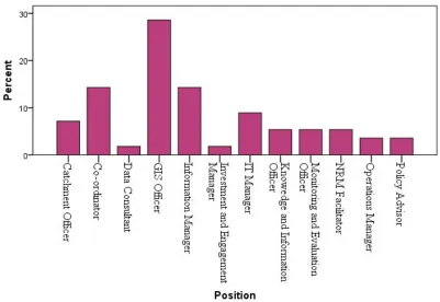
Figure 2: Profile of respondents (by position)
3.2 Areas and Factors Contributing Spatial Data Infrastructure Development
Though there are different views regarding definition and the components of spatial data infrastructure, the common terminology they have used is that spatial data infrastructure (SDI) is the infrastructure to facilitate spatial information access, use and sharing (UN Geospatial Information Working Group, 2007; Rajabifard et al., 2003; EU, 2006). These three areas (spatial information access, use and sharing) were selected and the variables contributing towards these areas were identified to explore the status of each of spatial information use, access and sharing in catchment management sectors.
323
[image:7.595.52.544.121.391.2]The three key areas and the contributing factors are provided in Table 2.
Table 2: Areas and contributing factors for spatial data infrastructure (SDI) development
Areas Contributing factors
Spatial Information Access Ease of access, restriction, impact of restriction, affordability of current pricing, spatial information access medium
Spatial Information Use Type of organisation, spatial information used by staff, GIS maturity, GIS activities, spatial information receiving medium
Spatial Information Sharing Collaborative arrangement, Networking, use of open source models and social media, spatial policy, cost of spatial data, funding
sources, importance of spatial data provider, spatial information integration issues, data sharing agreement
4 RESULTS
Spatial Information Access
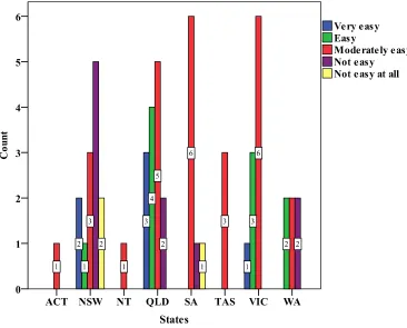
Figure 3: Ease of access to obtain spatial data from spatial data provider
However, in NSW, the majority of organisations advised that it was more difficult to access spatial information. It was possible that this was due to the restriction placed by the spatial data provider on their use of spatial data. The 6 out of 13 NSW NRM bodies advised that there were always restrictions on the use of spatial information provided by spatial data providers which limited their ability to undertake GIS activities. However, the majority of regional NRM bodies located in QLD, SA, VIC and NT advised that the restriction was not limiting their GIS activities. The majority of regional NRM bodies of TAS and WA advised that the restriction impacted on their ability to undertake GIS activities. In respect to pricing of spatial data, the majority (60%) of the organisations advised that the pricing of spatial information is affordable for their organisation and the most accepted pricing arrangement was the cost of transferring data. The majority of regional NRM bodies received their spatial information using ICT technology and digital media which also impacted spatial information access.
Spatial Information Use
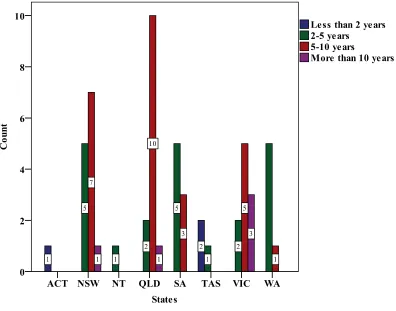
The regional NRM bodies also produce spatial information which provides a strong base to develop spatial data infrastructure (SDI) at catchment level. The majority of regional NRM bodies including QLD (93%), NSW (85%), VIC (80%), WA (67%), NT (100%), and TAS (100%) identified themselves as both spatial information providers and users. However, half of regional NRM bodies in SA and regional NRM body of ACT identified themselves as spatial information users only. With respect to the use of spatial information by regional NRM bodies’ staff, 40-60% of the total staff in NSW, QLD, VIC and WA used spatial information for catchment management activities. However, 60-80% of total staff in TAS and SA used spatial information for catchment management activities. The regional NRM bodies in Queensland, New South Wales and Victoria identified themselves as mature GIS organisations using spatial information for 5-10 years. However, the regional NRM bodies of Tasmania and Australian Capital Territory indicated limited experience of their spatial information use as shown in Figure 4.
325
Figure 4: Length of time using GIS
The majority of regional NRM bodies use a combination of in-house and outsourcing GIS activities. The majority of regional NRM bodies/CMAs in NSW, QLD, SA, VIC, NT and TAS are outsourcing some of their GIS activities. However, about half of the regional NRM bodies in WA are undertaking GIS activities completely in-house. The Western Australian Land Information System (WALIS) appears to have significantly influenced on WA regional NRM bodies to build capacity in-house GIS capacity. ACT regional NRM body have limited resources capacity to undertake GIS activities and outsource all GIS activities.
Spatial Information Sharing and Networking
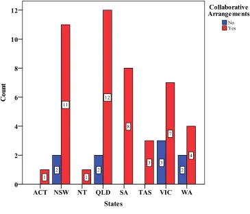
Figure 5: Collaborative Arrangements
The main partners for this collaboration and networking activities were state government organisations. Community organisations including other regional NRM bodies/CMAs were the second most common.
The majority (95%) of the regional NRM bodies/CMAs advised that they were aware of freely available/accessible spatial products e.g. Google Maps, OpenStreetMap, Wikimapia for their work needs. However, the utilisation of these products for catchment management activities is infrequent. The majority of regional NRM bodies of ACT, SA and WA were in the favour of using social media and open models for spatial information management. However, the other states were neutral on this issue. There is a growing utilisation of these new open models and social media for spatial information sharing and exchange at community level. However, there are some of good examples of the use this technology for information exchange and knowledge sharing. Due to the security, privacy and confidentiality, the regional NRM bodies are not yet very comfortable using these products.
5 DISCUSSION
327
Regional NRM bodies obtain spatial information from state government agencies and the access mechanism varies amongst Australian states. However, the majority of organisations responded that the spatial access mechanism was relatively straight forward. The access policy of state government organisation has impact on spatial information access. For example, the catchment management authorities in NSW had expressed some concerns with access to information. This may be due to the access policy and the restriction placed by NSW government. In NSW, all CMAs have access to similar state wide data and the main source is from an Enterprise database held at Parramatta. In respect to pricing of spatial data, the majority of regional NRM bodies advised that the pricing of spatial information was affordable for their organisation. However, the pricing do not affect the access of spatial information.
There are limited variations among Australian states regarding spatial information use. With respect to the use of spatial information by regional NRM bodies’ staff, the majority of staff are aware of spatial information and using it. The regional NRM bodies of NSW, QLD, VIC and WA are quite mature in comparison to other states. The half of WA regional NRM bodies undertaking their GIS activities house. There is great inspiration of state government organisation to build in-house GIS capacity of regional NRM bodies.
Information sharing, technology sharing, knowledge sharing, human resource sharing were the main areas of collaboration for spatial information management. The data sharing and spatial information management were the main areas of collaboration. Another emerging area for collaboration in NRM sector is knowledge sharing. The knowledge management and knowledge sharing is well-practised in NRM sector. The spatial data infrastructure could be one the component of spatial knowledge infrastructure and the main collaboration partners could be state government agencies and community organisations.
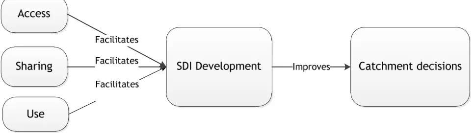
[image:11.595.57.540.441.581.2]Based on the above explanation, there is potential for spatial information access, use and sharing to contribute to SDI development. By building the spatial data infrastructure, disparate spatial information can be accessed and used to facilitate the sharing of spatial information between stakeholders across catchment communities and it will support sustainable catchment outcomes. Figure 6 indicates how spatial information access, use and sharing facilitate SDI development and can improve natural resource management outcomes.
Figure 6: Contribution of access, sharing and use for SDI development
The spatial information access, sharing and use facilitates spatial data infrastructure (SDI) development in natural resource management sector which improves the catchment decisions as shown in figure 6. Thus, the SDI development strategy can be influenced by the policies on spatial information access, use and sharing.
6 CONCLUDING REMARKS
in gaining access to this spatial data/information. This circumstance has opened a new way of collaboration between regional NRM bodies and state government organisations for better NRM outcomes. The access, use and sharing of spatial information between state government agencies and regional NRM bodies is therefore becoming more important for the development of spatial data infrastructure (SDI) at catchment level. Particularly, the SDI development strategy can be influenced by the policies on spatial information access, use and sharing.
The access policy of state government organisations has impact on spatial information access the state. The catchment management authorities in NSW had expressed some concerns with access to spatial information in comparison to other states. This may be due to the access policy and restriction placed by NSW government. Regarding the spatial information use, the regional NRM bodies of NSW, QLD, VIC and WA are quite mature in comparison to other states. The state government organisations appear to have significantly influenced regional NRM bodies to build capacity for spatial information management. The Western Australian Land Information System (WALIS) is a very good example of GIS capacity used to build WA regional NRM bodies.
We found the data sharing and spatial information management is the main areas of collaboration between state government organisations and regional NRM bodies. Another emerging area of collaboration is knowledge sharing. There is also growing utilisation of open models and social media for spatial information management and knowledge sharing at community level. The spatial data infrastructure could be the one of the component of spatial knowledge infrastructure. However, this is a new area and how spatial knowledge infrastructure and spatial data infrastructure could be inter-linked for better catchment outcomes need to be further explored.
REFERENCES
AFFA. (2002). Scientific Advice to the Parliament of the Commonwealth of Australia: The Department of Agriculture, Fisheries and Forestry, Australia.
Central Coast Regional Catchment Committee. (1999), A submission to the Standing Committee’s
inquiry into Catchment Management. Available:
www.aph.gov.au/house/committee/environ/cminq/sub115-e.pdf, accessed 15 September,
2011.
Clinton, W. J. (1994), Coordinating geographic data acquisition and access to the National Spatial
Data Infrastructure. Executive Order 12096. Available:
http://govinfo.library.unt.edu/npr/library/direct/orders/20fa.html, accessed 15 September
2011.
EU. (2006). Assessing the Impacts of Spatial Data Infrastructure. Brussels: Joint Research Centre EU.
Feeney, M.-E. F. (2003), 'SDIs and Decision Support' In Developing Spatial Data Infrastructures
From concept to reality (Eds, Williamson, I. P., Rajabifard, A. and Feeney, M.-E. F.) Taylor
& Francis, London, UK pp. 195-210.
Folger, P. (2011), Geospatial Information and Geographic Information Systems (GIS): An Overview
for Congress. Congressional Research Service, R41825, USA
Available: http://www.fas.org/sgp/crs/misc/R41825.pdf, accessed 15 September, 2011.
Gore, A. (1998), The Digital Earth: understanding our planet in the 21st century. Digital Earth, Wikipedia. Available: http://en.wikipedia.org/wiki/Digital_Earth, accessed 15 September 2011.
Laut, P., Taplin, B. J. and CSIRO. Division of Water Resources. (1989), Catchment management
in Australia in the 1980s, CSIRO Institute of Natural Resources and Environment Division
329
Longley, P. A., Goodchild, M. F., D.J., M. and Rhind, D. W. E. (Eds.) (1999) Geographic
Information Systems, John Wiley & Sons, New York.
Masser, I. (Ed.) (2005) GIS Worlds, Creating Spatial Data Infrastructures, ESRI Press, Redlands,California.
McDougall, K. and Rajabifard, A. (Eds.) (2007) A Mixed-Method Approach for Evaluating Spatial
Data Sharing Partnerships for Spatial Data Infrastructure Development, ESRI Press
Redlands, California, USA.
Pannell, D. J., Ridley, A., Seymour, E., Regan, P. and Gale, G. (2008) In SIF3 Working Paper
0809, CRC for Plant-Based Management of Dryland SalinityPerth.
Paudyal, D. R. and McDougall, K. (2008), Building Spatial Data Infrastructure to Support
Sustainable Catchment Management. Paper presented at the Queensland Spatial
Conference 2008, 17-19 July, 2008 Gold Coast, Queenslands.
Rajabifard, A., Feeney, M.-E. F. and Williamson, I. (2003), 'Spatial Data Infrastructures: Concept, Nature and SDI Hierarchy' In Developing Spatial Data Infrastructures: From Concept to
Reality (Eds, Williamson, I., Rajabifard, A. and Feeney, M.-E. F.) Taylor & Francis, London,
UK, pp. 17-40.
Ryan, S., Broderick, K., Sneddon, Y. and Andrews, K. (Eds.) (2010) Australia’s NRM Governance
System: Foundations and Principles for Meeting Future Challenges, Australian Regional
NRM Chairs,Canberra.
The Parliament of the Commonwealth of Australia. (2002). Co-ordinating Catchment
Management:Report on the Inquiry into Catchment Management: House of
Representatives Standing Committee on Environmental Heritage.
UN Geospatial Information Working Group. (2007). Strategy for Developing and Implementing a